Strategic Review of Geoscience Australia - Department of Finance
Upload
richard-laneCategory
view
271download
5description
22nd ASEG International Conference & Exhibition 2012© Commonwealth of Australia (Geoscience Australia) 2012
The strong attraction of gravity at Geoscience Australia
Richard Lane
Geoscience Australia

© Commonwealth of Australia (Geoscience Australia) 2012
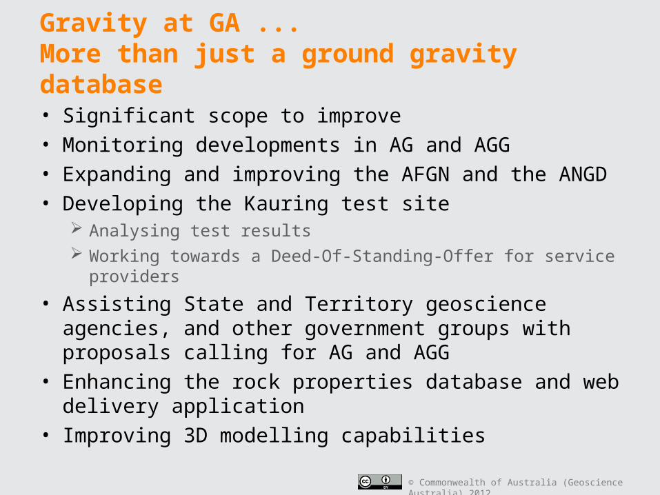
Gravity at GA ...More than just a ground gravity database
• Significant scope to improve The quality and extent of the coverage By providing better support to help interpret and integrate gravity with
other geoscientific information
• Monitoring developments in AG and AGG
• Expanding and improving the AFGN and the ANGD
• Developing the Kauring test site Analysing test results Working towards a Deed-Of-Standing-Offer for service providers
• Assisting State and Territory geoscience agencies, and other government groups with proposals calling for AG and AGG
• Enhancing the rock properties database and web delivery application
• Improving 3D modelling capabilities

© Commonwealth of Australia (Geoscience Australia) 2012
The Long Term (Ideal) Objective
Global Satellite or Satellite+Shipborne+Ground data
Airborne Gravity (AG)
Airborne Gravity Gradiometry(AGG)
Onshore coverage:Airborne gravity gradiometer data at 1 km line spacing
Coastal zone, offshore (EEC) and Antarctic coverage:Airborne gravity data at 2 km spacing
Base coverage:Global Satellite or Satellite+Shipborne+Ground gravity models
© Commonwealth of Australia (Geoscience Australia) 2012
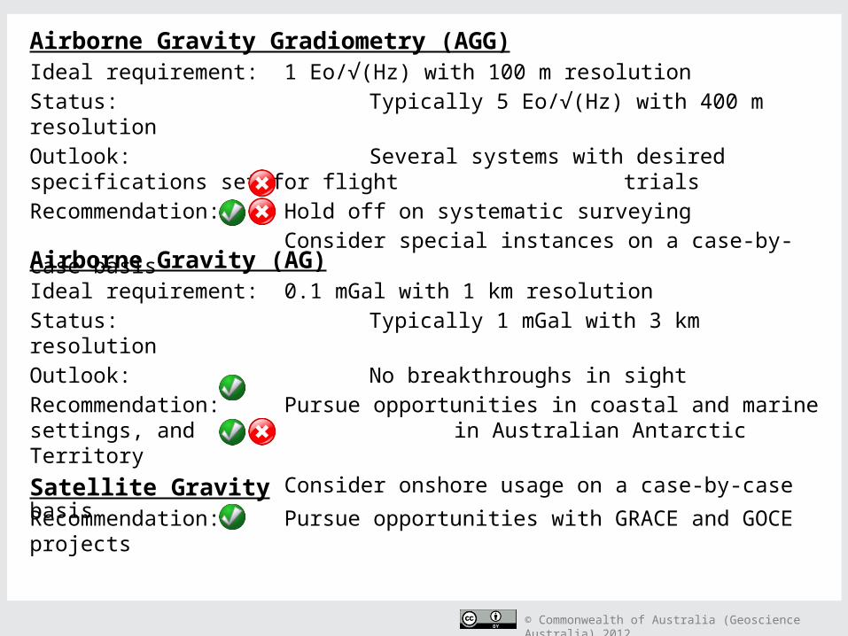
Airborne Gravity Gradiometry (AGG)Ideal requirement: 1 Eo/√(Hz) with 100 m resolutionStatus: Typically 5 Eo/√(Hz) with 400 m resolutionOutlook: Several systems with desired specifications set for flight
trialsRecommendation: Hold off on systematic surveying
Consider special instances on a case-by-case basis
Airborne Gravity (AG)Ideal requirement: 0.1 mGal with 1 km resolutionStatus: Typically 1 mGal with 3 km resolutionOutlook: No breakthroughs in sightRecommendation: Pursue opportunities in coastal and marine settings, and
in Australian Antarctic TerritoryConsider onshore usage on a case-by-case basis
Satellite GravityRecommendation: Pursue opportunities with GRACE and GOCE projects

© Commonwealth of Australia (Geoscience Australia) 2012
Satellite Gravity

© Commonwealth of Australia (Geoscience Australia) 2012
GRACE - Gravity Recovery and Climate Experiment
(Courtesy of NASA and DLG)

© Commonwealth of Australia (Geoscience Australia) 2012
GOCE - Gravity Field and Steady-State Ocean Circulation Explorer
(Courtesy of ESA)

© Commonwealth of Australia (Geoscience Australia) 2012
http://icgem.gfz-potsdam.de/ICGEM/
Global model GGM03C
Combined GRACE, ground and satellite
altimetric gravity model
(Courtesy of ICGEM - IAG)
© Commonwealth of Australia (Geoscience Australia) 2012
Airborne Gravity(AG)

© Commonwealth of Australia (Geoscience Australia) 2012
Gippsland Nearshore Airborne Gravity SurveyVictorian Department of Primary Industries (DPI)
• Consistent mapping of
geological structure
between onshore and
offshore• Sander AirGRAV
120 x 70 km area 10,500 km 1 km spacing RMS of 1.6 µms-2 for 3
km half wavelength
• Kauring Test Site in WA also flown
( http://www.dpi.vic.gov.au/energy/sustainable-energy/carbon-capture-and-storage/the-carbonnet-project/airborne-gravity-survey )
Survey outline

© Commonwealth of Australia (Geoscience Australia) 2012
Airborne GravityGradiometry
(AGG)

© Commonwealth of Australia (Geoscience Australia) 2012
Status update on existing AGG systems
• ARKeX – FTGAdding a GMA Gz sensor to an existing FTG system
• Bell Geospace – Air-FTGTesting a combination of Air-FTG and ZTEM AEM (an
ambient EM system – Geotech)
• Fugro – FALCONLatest system (#5, “Cavendish”) delivered
HeliFALCON in commercial use since early 2011
Successful test flight of FALCON and TEMPEST AEM systems

© Commonwealth of Australia (Geoscience Australia) 2012
Status update on new AGG systems
• Rio Tinto – VK1 – 1 Eo per root Hz “Active period of airborne testing at the Kauring Test Site”
• Lockheed Martin - Enhanced FTG - 2 Eo per root Hz “The system build and initial test will be completed in July
2012”
• ARKeX - EGG Exploration Gravity Gradiometer – 1 Eo per root Hz “2 instruments built, ongoing flight trials”
• Gedex - High Definition Airborne Gravity Gradiometer HD-AGG™ - 1 Eo per root Hz “Upgrades are being implemented (following initial flight
trials), and the flight testing will resume in April 2012”

© Commonwealth of Australia (Geoscience Australia) 2012
“Certainly the benchmark for airborne gravity.”(GW – University of Utah / TechnoImaging)
“… the most comprehensive resource for this rapidly evolving technology. I believe that this is an important contribution by GA to the exploration and geological mapping community.”(CF – CSIRO)
“… the proceedings was a very professionally put together document and will be an important resource for years to come.”(DH – Gedex Inc.)
“I think it is terrific that Geoscience Australia supports such initiatives, and produces the record of proceedings.”(GW – BHP Billiton)
“… the GA publication of the workshop proceedings is of the highest quality.”(DDF – Lockheed Martin)
( https://www.ga.gov.au/products/servlet/controller?event=GEOCAT_DETAILS&catno=70673 )

© Commonwealth of Australia (Geoscience Australia) 2012
AFGN and ANGD

© Commonwealth of Australia (Geoscience Australia) 2012
Land relative gravimeters
Scintrex CG-5 AUTOGRAVLaCoste Romberg Model G

© Commonwealth of Australia (Geoscience Australia) 2012
Land absolute gravimeter
Micro-g LaCoste A10
(Photographs courtesy of Ray Tracey - GA)

© Commonwealth of Australia (Geoscience Australia) 2012
AFGN absolute gravity observations
(Courtesy of Ray Tracey, GA)

© Commonwealth of Australia (Geoscience Australia) 2012
Absolute and relative gravity measurements in Antarctica
• Absolute gravity reference points
• Relative gravity observations to tie existing survey data to the absolute reference points
(http://www.ga.gov.au/ausgeonews/ausgeonews201006/inbrief.jsp )(Photograph of Ray Tracey - GA)

© Commonwealth of Australia (Geoscience Australia) 2012
AAGD07 and revised processing equations and procedures• Absolute gravity observations for ~ 60 stations in the Australian
Fundamental Gravity Network (AFGN) define AAGD07 New datum replaces the Isogal84 datum
Linked by relative observations to the IGSN71 global datum
(Approximately) Supported by sparse, older absolute gravity observations
• g(AAGD07) = g(ISOGAL84) – 0.78 μms-2
• Applied to >1.4 M observations in the Australian National Gravity Database (ANGD)
• Also implemented revised processing equations and procedures More accurate equations Ellipsoid height datum and GDA94 horizontal datum

© Commonwealth of Australia (Geoscience Australia) 2012
Observation uncertainty
• Australian National Gravity Database (onshore)• Uncertainty estimates
Standard deviation assuming a Gaussian error distribution Horizontal location Vertical location Observed vertical gravity (Terrain corrections)
• Combined uncertainty estimate for simple Bouguer vertical gravity values
• 0.2 μms-2 to more than 20 μms-2

© Commonwealth of Australia (Geoscience Australia) 2012
Sources of uncertainty values
1. Operations/Acquisition Report2. Processing Report3. Typical performance of reported
method/equipment used4. Typical performance of assumed
method/equipment5. Estimated from the date of the survey by
reference to other surveys of a similar vintage
6. Analysis of the external network adjustment errors
7. Unknown source

© Commonwealth of Australia (Geoscience Australia) 2012
Observation uncertainty – example of estimation from supplied uncertaintiesh uncertainty in horizontal position in
metres
v uncertainty in vertical position in metres
εobs vertical gravity observation error in μms-2
φ latitude in degrees north
εht vertical gravity error in μms-2 associated
with uncertainty in horizontal positioning
εvfa error in μms-2 for free-air corrected
vertical gravity due to uncertainty in vertical positioning
εv error in μms-2 for simple Bouguer
anomaly vertical gravity due to uncertainty in vertical positioning, given a correction density of 2670 kg/m3
εtc uncertainty in the accuracy of terrain
corrections in μms-2
2sin01.0 hht
vvfa 3
vv 2
222obsvfahtFA
2222tcobsvhtCBA

© Commonwealth of Australia (Geoscience Australia) 2012
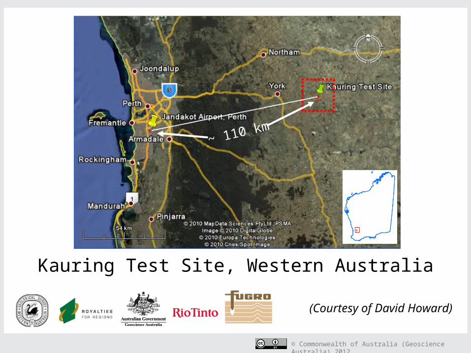
Kauring Test Site
© Commonwealth of Australia (Geoscience Australia) 2012
Kauring Test Site, Western Australia
~ 110 km
(Courtesy of David Howard)

© Commonwealth of Australia (Geoscience Australia) 2012
Kauring referencegravity data
• Continental data Variable spacing
• Regional data 150 x 150 km @ 2 km spacing
• Airborne Gravity site 20 x 20 km @ 500 m spacing
• Airborne Gravity Gradiometer site
5 x 6 km area at variable spacing
50 x 50 m; 100 x 50 m; 250 x 100 m
Plus LiDAR DEM with 1 m grid cells
*Perth

© Commonwealth of Australia (Geoscience Australia) 2012
FALCON AGG data
• Flown July 2011
• Height ~70 m
• Line spacing 50 m
• Noise 1.9 Eo RMS
• Bandwidth 0.18 Hz
GDD from ground gravity
GDD from FALCON(Courtesy of Mark Dransfield, FAS)

© Commonwealth of Australia (Geoscience Australia) 2012
Ground reference gravity Equivalent source model
Recovered inversion model
Simulate data for various systems
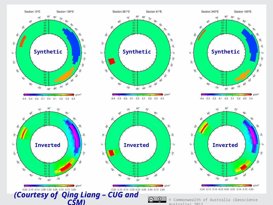
CSM CGEM synthetic studies
(Courtesy of Cericia Martinez and Yaoguo Li, CSM)
Invert data simulated for various systems
Compare inversion models

© Commonwealth of Australia (Geoscience Australia) 2012
VK1a 60°headingLow noise next-generation FTG system
Simulated data and inversion models
VK1c 60°heading
vkc
Eo
(Courtesy of Cericia Martinez and Yaoguo Li, CSM)

© Commonwealth of Australia (Geoscience Australia) 2012
1 km
AnomaliesAnomalies + 1 EöAnomalies + 10 Eö (400 m wavelength)
“Kauring Challenge”• Simulated the AGG response
for known bodies beneath the
Kauring terrain
Gzz, 80 m clearance, 1 Hz
sampling
• Added noise 1 Eö or 10 Eö
• Data available for inversion
studiesDeep Slab
Depth below ground 500 m
Volume 48 Million m3
Excess mass 10 MT @ 0.2 g/cc contrast
Peak response 2.5 Eö
Comments Broad wavelength, Low response
North East Dipping Dyke
Depth below ground At surface
Volume 225 Million m3
Excess mass 34 MT @ 0.15 g/cc contrast
Peak response 12 Eö
Comments 75 m thick, dipping at 45°
Sphere (NiS body)
Depth below ground 50 m
Volume 14 Million m3
Excess mass 4.5 MT @ 0.3 g/cc contrast
Peak response 30 Eö
Comments 150 m radius
Kimberlite
Depth below ground 150 m
Volume 3.5 Million m3
Excess mass 1.5 MT @ -0.4 g/cc contrast
Peak response 12 Eö
Comments Truncated cone, 100 m upper rad
Tunnel
Depth below ground 3 m
Volume 8 000 m3
Excess mass 0.02 MT @ -2.67 g/cc contrast
Peak response 0.8 Eö
Comments 4 m square tunnel, 500 m long
1 km
(Courtesy of Theo Aravanis, Rio Tinto)

© Commonwealth of Australia (Geoscience Australia) 2012
( http://www.ga.gov.au/minerals/projects/current-projects/kauring.html)
Kauring Test Site, WA
• www.ga.gov.au Search for “Kauring”
• Reference data sets Magnetic, radiometric,
elevation, gravity and digital geology
• Simulated data sets• Bibliography• Test flight protocols• Observed AG and AGG
data sets

© Commonwealth of Australia (Geoscience Australia) 2012
Rock Properties

© Commonwealth of Australia (Geoscience Australia) 2012
Geoscience Australia rock properties web delivery application
• Very simple database structure
• Basic search and download application on our website
• And now ...
• Populating the database Existing density and magnetic
property observations
• Hoping to expand the scope of the database Additional property types
Access to the data via a Web Feature Service (WFS)
( http://www.ga.gov.au/geophysics-rockpropertypub-web/rockproperties/search.htm )

© Commonwealth of Australia (Geoscience Australia) 2012
Modelling

© Commonwealth of Australia (Geoscience Australia) 2012
CBA as a response compensated for various model elements• GADDS
Primary observations Plus residual gravity - excluded defined source features
• Tides Sun and the Moon
• Theoretical gravity (including free air correction) Earth as a point mass or source with spherically symmetric
density• Bouguer cap
~ 167 km radius Simple Bouguer anomalies (SBA)
• Terrain correction ~ 167 km radius Complete Bouguer anomalies (CBA)

© Commonwealth of Australia (Geoscience Australia) 2012
CBA extensions
• Distant relief correction The rest of the globe Beyond the (arbitrary) ~167 km radius used for Bouguer
anomaly values• Isostatic correction
Various models for isostatic compensation• Crustal models - v1, v2, v3, etc
e.g., CRUST2 global seismic-based model GA regional models Semi-regional models District models Prospect models etc ...
• Make available as options via GADDS

© Commonwealth of Australia (Geoscience Australia) 2012
Ptolemy Magellan’s Expedition
Spherical mesh elementsApollo 17

© Commonwealth of Australia (Geoscience Australia) 2012
Australia's maritime jurisdiction

© Commonwealth of Australia (Geoscience Australia) 2012
CUG-CSM-GA International Project - Spherical mesh geometry gravity and magnetic modelling

© Commonwealth of Australia (Geoscience Australia) 2012
Synthetic result for gravity modelling with a spherical mesh
Model resolution: 6°×6°× 10km# of cells: 60×30×10=18000
Data resolution: 6°×6°# of data points: 60×30=1800
(Courtesy of Qing Liang, CUG and CSM)

© Commonwealth of Australia (Geoscience Australia) 2012
Theoretical data with
noise
Predicted data
(Courtesy of Qing Liang, CUG and CSM)
© Commonwealth of Australia (Geoscience Australia) 2012
Synthetic
Inverted Inverted Inverted
Synthetic Synthetic
(Courtesy of Qing Liang – CUG and CSM)
© Commonwealth of Australia (Geoscience Australia) 2012
Gravity at GA ...More than just a ground gravity database
• Significant scope to improve• Monitoring developments in AG and AGG• Expanding and improving the AFGN and the ANGD• Developing the Kauring test site
Analysing test results Working towards a Deed-Of-Standing-Offer for service providers
• Assisting State and Territory geoscience agencies, and other government groups with proposals calling for AG and AGG
• Enhancing the rock properties database and web delivery application
• Improving 3D modelling capabilities