
The South East Australia Climate Initiative ACRE workshop, April2, 2009 Brief description Summary of...
32
The South East Australia Climate Initiative ACRE workshop, April2, 2009 • Brief description • Summary of themes • Issues • Spatial problem (downscaling) • Temporal problem (synthetic time series) Acknowledgements: SEACI colleagues, Wendy Craik, Bryson Bates, QCCCE colleagues
-
Upload
ethelbert-myron-leonard -
Category
Documents
-
view
214 -
download
0
Transcript of The South East Australia Climate Initiative ACRE workshop, April2, 2009 Brief description Summary of...

The South East Australia Climate InitiativeACRE workshop, April2, 2009
• Brief description
• Summary of themes
• Issues• Spatial problem (downscaling)
• Temporal problem (synthetic time series)
Acknowledgements:
SEACI colleagues, Wendy Craik, Bryson Bates, QCCCE colleagues

The Murray-Darling Basin
14% of Australia14% of Australia
Over 2 million peopleOver 2 million people
1million sq. km1million sq. km

Snapshot of the MDB
•Major river systems
Murray River 2530 km
Darling River 2740 km
Canberra
Sydney
Brisbane
NEW SOUTH WALES
QUEENSLAND
VICTORIA
SOUTHAUSTRALIA
Melbourne
Swan Hill
MilduraMorgan
Menindee
MenindeLakes
LakeVi ctoria
Albury
Forbes
Dubbo
Moree
Charleville
Bourke
MurrayMurrumbidgie
Lachlan
Darling Macquarie
Border
Balonne
Barwon
Warrego
Adelaide
200 km
Murray Bridge
O’Reilly’s

Basin characteristics
Length 3,370km
Basin size 1,050,116 km²
Population 2 million
Population density 2 people/km²
Key economic activity agriculture, tourism, mining, manufacturing
Key issues risks to shared water resources, overallocation

Average yearly rainfall in the MDB

Distribution of surface run-off
1.0%
1.7%
0.4%
20.3%
23.3%
1.9%
0%6.1%
0.3%
21.1%
10.6%
13.3%
1.0%
1.7%
0.4%
20.3%
23.3%
1.9%
0%6.1%
0.3%
21.1%
10.6%
13.3%

http://www.mdbc.gov.au
August 2008

http://www.mdbc.gov.au/__data/page/1366/Drought_Update_Issue_14_-_July_2008.pdf

Key Features SEACI (Phase 1) 2006-2008
SEACI2 (Phase 2) July, 2009 - June, 2012
Further extension (2 years) subject to review
Investigating the causes and impacts of climate change and variability across south eastern Australia, and developing
improved short-term predictions for hydrological and agricultural applications
Research themes:1. Understanding past hydroclimate variability and change in SEA
2. Long-term hydroclimate projections in SEA 3. Seasonal hydroclimate prediction in SEA

SE
AC
I
STA
KE
HO
LDE
RS
SC
IEN
CE
MDBA
DCC
VDSE
MCVP
CAWCR

1. Understanding past hydroclimate variability and change in SEA

Detection and attribution:Observed trends
Role of:
GH gases ?
Aerosols ?
Ozone ?
Land cover change ?
Natural variability ?
Other ?

Observed trends
(in rainfall, mm per 10 yrs)

Probable causes: sub-tropical ridge intensity
Adapted from Timbal (2007)

Timbal, 2007 (SEACI)

2. Long-term hydroclimate projections in SEA

Rainfall
Percent difference (1997-2006 relative to 1895-2006)
Rainfall Runoff
1997–2006 rainfall and runoff
Understanding observed changes in runoff

Climate and runoff projections

GCM ID Weighted failure rate (%)(Table 2)
UKMO-HadCM3 0
MIROC3.2(hires) 8
GFDL-CM2.1 13
GFDL-CM2.0 20
MIROC3.2(medres) 25
ECHO-G 33
UKMO-HadGEM1 33
ECHAM5/MPI 38
MRI-CGCM2.3.2 40
CCSM3 44
CGCM3.1(T63) 50
GISS-AOM 58
INM-CM3.0 59
CGCM3.1(T47) 63
FGOALS-G1.0 63
CSIRO-Mk3.0 73
CNRM-CM3 75
IPSL-CM4 75
BCCR-BCM2.0 88
GISS-ER 88
PCM 89
GISS-EH 100
Ranking of (AR4) GCM performance to improve of regional climate change projections and impacts.
•There are models which consistently perform relatively well, and also models which consistently underperform
•Provides a basis for better weighting, if not excluding, some model results when forming projections
•There is (but not always) evidence of clustering in the projected changes from better performing models
Assessment of GCMs

Downscaling
Relating local-scale weather & climate to large-scale atmospheric variables (modelled or observed)

Downscaling Applications
• Investigations of interannual and multidecadal climate variability at regional scales
• Climate change scenarios at local and/or regional scales
• Detection & attribution of climate change at regional scales
• Seasonal prediction at local &/or regional scales

Spatial problem:Getting from GCM coarse scale results
(100kmx100km)to catchment scales.
200k
m

Spatial problem:GCMs cannot represent regional scale
features that drive local climate
Sea level

Spatial problem:
Statistical downscaling
T
U
RH
Z
Rainfall=f2(T,RH,Z,U,….)
c.f.Antonio Cofino
Rainfall=f1(T,RH,Z,U,….)

Murrumbidge Weather States

Atmospheric Predictors

Spatial problem:Dynamical downscaling?
c.f.Antonio Cofino
Still only ~ 10km
Expensive
200k
m

Downscaling can be complicated…

20081900 2100
Sample obs
PDF for natural varib.
2050 climate projection
rain
fall
Currently
rain
fall
20081900 2100
PDF for natural varib. and model greenhouse signal uncertainty
We need
Temporal problem:Integration of historical climate data with
projection information
Current (2008) climate and future climate can be estimated the same way: model signal plus natural variability
Climate envelope will be modified as time goes by based on model improvement and evaluation, and assimilation of the observed trend by some means (Penny Whetton)

One option for generating synthetic weather series which capture climate change signals
Assume the climate at site A is projected to resemble the present-day climate at site B by 2100. A feasible synthetic weather series may be
Past to the present: site A as observed
2100: Site B as observed
Present to 2100: Weighted between A and B
(preserves correlation between variables)
A
B
Warmer and drier
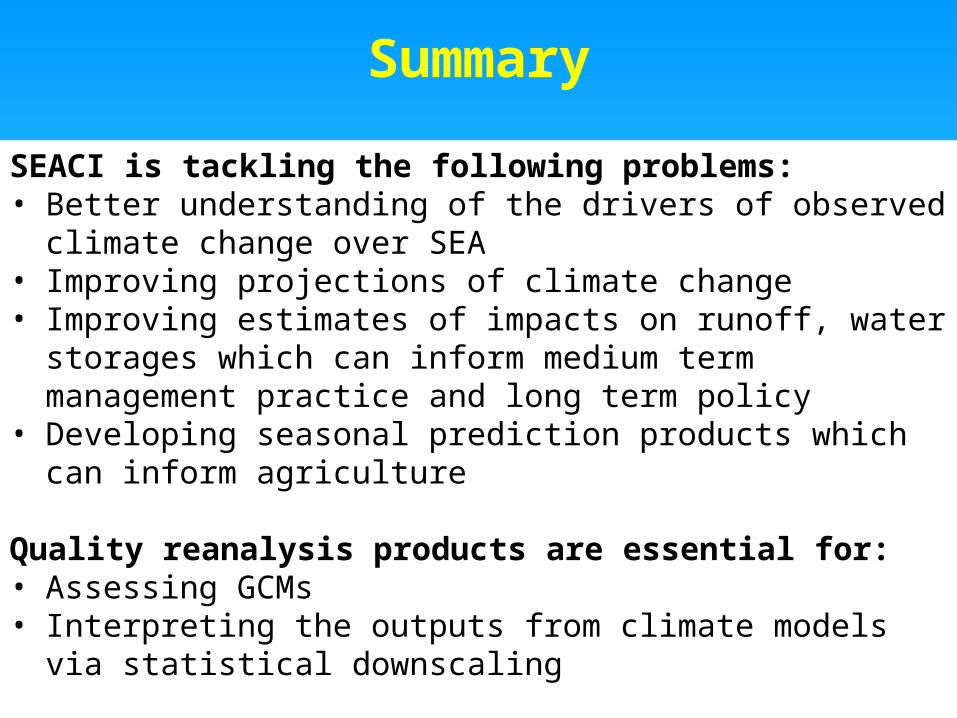
SEACI is tackling the following problems:• Better understanding of the drivers of observed climate change
over SEA• Improving projections of climate change• Improving estimates of impacts on runoff, water storages which
can inform medium term management practice and long term policy
• Developing seasonal prediction products which can inform agriculture
Quality reanalysis products are essential for:• Assessing GCMs• Interpreting the outputs from climate models via statistical
downscaling
Summary

Climate change projections
P
Q
P
QP = median P = median
Qt – QQt – Q
Pt – PPt – P
RAINFALL
RUNOFF
ET
ET
Estimation of impact on runoff
< 22 – 2.52.5 – 3> 3
< 22 – 2.52.5 – 3> 3
Hydrologic sensitivity to runoff
Runoff projections
Water Availability