The Socio-Economic Benefits of GMES
96
Report 39 November 2011 Christina Giannopapa The Socio-Economic Benefits of GMES A Synthesis Derived from a Comprehensive Analysis of Previous Results, Focusing on Disaster Management This report was prepared under the auspices of the 2011 Polish Presidency of the Council of the European Union. The sole responsibility for the content of this publication lies with ESPI.
Transcript of The Socio-Economic Benefits of GMES
Report 39 November 2011
Chr ist ina Giannopapa
The Socio-Economic Benefits of GMES A S yn t he s i s De r i v e d f r om a C omp r ehen s i v e Ana l y s i s o f P r e v i o u s Re su l t s , F o c u s i ng on D i s a s t e r Managemen t
This report was prepared under the auspices of the 2011 Polish Presidency of the Council of
the European Union. The sole responsibility for the content of this publication lies with ESPI.
ESPI Report 39 2 November 2011
Short title: ESPI Report 39 ISSN: 2076-6688 Published in November 2011 Price: €11
Editor and publisher: European Space Policy Institute, ESPI Schwarzenbergplatz 6 • 1030 Vienna • Austria http://www.espi.or.at Tel. +43 1 7181118-0; Fax -99
Rights reserved – No part of this report may be reproduced or transmitted in any form or for any purpose with-out permission from ESPI. Citations and extracts to be published by other means are subject to mentioning “Source: ESPI Report 39; November 2011. All rights reserved” and sample transmission to ESPI before publish-ing.
This report was prepared under the auspices of the 2011 Polish Presidency of the Council of the European Un-ion. The sole responsibility for the content of this publication lies with ESPI.
ESPI is not responsible for any losses, injury or damage caused to any person or property (including under contract, by negligence, product liability or otherwise) whether they may be direct or indirect, special, inciden-tal or consequential, resulting from the information contained in this publication.
Design: Panthera.cc
The Socio-Economic Benefits of GMES
ESPI Report 39 3 November 2011
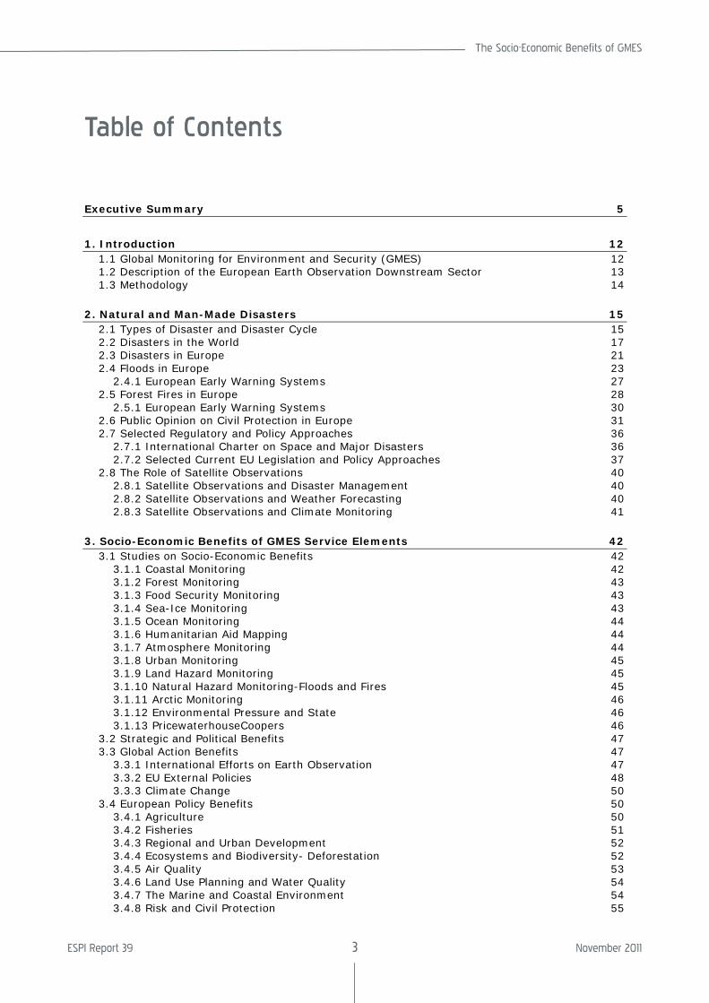
Table of Contents
Executive Summary 5
1. Introduction 12 1.1 Global Monitoring for Environment and Security (GMES) 12 1.2 Description of the European Earth Observation Downstream Sector 13 1.3 Methodology 14
2. Natural and Man-Made Disasters 15
2.1 Types of Disaster and Disaster Cycle 15 2.2 Disasters in the World 17 2.3 Disasters in Europe 21 2.4 Floods in Europe 23
2.4.1 European Early Warning Systems 27 2.5 Forest Fires in Europe 28
2.5.1 European Early Warning Systems 30 2.6 Public Opinion on Civil Protection in Europe 31 2.7 Selected Regulatory and Policy Approaches 36
2.7.1 International Charter on Space and Major Disasters 36 2.7.2 Selected Current EU Legislation and Policy Approaches 37
2.8 The Role of Satellite Observations 40 2.8.1 Satellite Observations and Disaster Management 40 2.8.2 Satellite Observations and Weather Forecasting 40 2.8.3 Satellite Observations and Climate Monitoring 41
3. Socio-Economic Benefits of GMES Service Elements 42
3.1 Studies on Socio-Economic Benefits 42 3.1.1 Coastal Monitoring 42 3.1.2 Forest Monitoring 43 3.1.3 Food Security Monitoring 43 3.1.4 Sea-Ice Monitoring 43 3.1.5 Ocean Monitoring 44 3.1.6 Humanitarian Aid Mapping 44 3.1.7 Atmosphere Monitoring 44 3.1.8 Urban Monitoring 45 3.1.9 Land Hazard Monitoring 45 3.1.10 Natural Hazard Monitoring-Floods and Fires 45 3.1.11 Arctic Monitoring 46 3.1.12 Environmental Pressure and State 46 3.1.13 PricewaterhouseCoopers 46
3.2 Strategic and Political Benefits 47 3.3 Global Action Benefits 47
3.3.1 International Efforts on Earth Observation 47 3.3.2 EU External Policies 48 3.3.3 Climate Change 50
3.4 European Policy Benefits 50 3.4.1 Agriculture 50 3.4.2 Fisheries 51 3.4.3 Regional and Urban Development 52 3.4.4 Ecosystems and Biodiversity- Deforestation 52 3.4.5 Air Quality 53 3.4.6 Land Use Planning and Water Quality 54 3.4.7 The Marine and Coastal Environment 54 3.4.8 Risk and Civil Protection 55
ESPI Report 39 4 November 2011
3.5 Benefits per Area 57 4. Quantification of the Socio-Economic Benefits 70
4.1 PricewaterhouseCoopers 70 4.1.1 Categories of Benefits 70 4.1.2 Benefits Evolution 70 4.1.3 Summary of Total Benefits 72
4.2 booz&co 74 4.2.1 Approach 74 4.2.2 Cost-Benefit Analysis 75 4.2.3 Results 78 4.2.4 Comparison with Other Studies 79 4.2.5 Conclusion 80
5. Conclusions and Recommendations 82
5.1 Overview 82 5.2 Analysis and Recommendations by Factor 85
List of Acronyms 89
Annex 91 A.1 JRC Terminology and Typology for Natural Disasters 91 A.2 Categories of Benefits 91
Acknowledgements 93
About the Author 93
The Socio-Economic Benefits of GMES
ESPI Report 39 5 November 2011
Executive Summary
Overview
Disasters have a significant socioeconomic effect on economy and societies. Even though there are no internationally agreed minimum criteria for an event to be classified as a dis-aster, the number of reported damage caused by disasters during the last decade has doubled compared to those reported in the previous decade. There are various rea-sons that can explain this increase. In the first instance, the increase is probably due to the population growth and assets with higher economic value in exposed areas and the possibility to better assess the impacted ar-eas and report correspondingly. There is some evidence that climate change may con-tribute to the increasing frequency and inten-sity of natural hazards, as well. During the last decade amongst the top ten countries of very high human development by disaster occurrence in the world are the European Union Member States Germany with 29.9 billion US$ of losses, France with 17.9 billion US$, Italy with 13.4 billion US$, United King-dom with 12.1 billion US$ and Greece with 2.9 billion US$ of losses in damages. Overall in Europe1 during the last decade almost 100,000 fatalities occurred, more than 11 million people were affected, and reported losses amounted to more than 200 billion EUR. The first most important natural disas-ter in Europe regarding economic losses is flooding resulting in 52.173 billion EUR of losses over the decade. The second most important are storms resulting in 44.338 billion EUR losses, and the third is earth-quakes with 29.205 billion EUR losses. After that follows extreme temperature events with 9.962 billion EUR, forest fires with 6.917 bil-lion EUR and drought with 4.940 billion EUR losses2. Losses due to avalanches, landslides, and volcanoes are of a smaller scale.
The first study at the European level of the public opinion on civil protection was com-pleted in 20093, focusing on risk perception in
1 European Environment Agency (EEA) Mapping the Impacts of Natural Hazards and Technological Accidents in Europe. EEA Technical Report 13. 2010: 66 – 68. 2 EFFIS, 2010. 3 European Commission. Special Eurobarometer. Civil Protection. Full Report. Special Eurobarometer 328/Wave 72.2 – TNS Opinion & Social. Nov. 2009.
natural and man made disasters and the per-ception of European or national approaches to civil protection in the various stages of the disaster cycle. The research showed that the perception of risk by the public is slightly different than fact. The top five perceived risks were flooding, storms, industrial acci-dents, forest fires and earthquakes. Natu-rally, the distribution varies from country to country in the EU. Regarding the approaches to civil protection, an overwhelming majority of Europeans believe that more should be done on European level by setting up a re-serve of assets such as fire fighting planes, flood water pumps and specially trained staff regarding response, preparedness and pre-vention to support Member States efforts. Additionally, the majority believes there should be at EU level development of com-mon warning signals for emergencies, com-mon risk measures as they exist for floods and common standards. Another study pub-lished the same year shows Europeans be-lieve with an overwhelming majority that it is important for Europe to develop Earth obser-vation systems to monitor the environment including natural disasters4. However, even though the majority is aware that Europe is developing its own Earth observation sys-tems, it would appear necessary that efforts be made to raise further the awareness about them.
There are a number of regulatory and policy approaches in Europe that impact the disas-ter cycle. The European Commission is cur-rently developing guidelines on disaster risk management. Disaster risk reduction and management has shifted from a response-oriented approach towards an integrated risk management approach. This includes preven-tion, preparedness, response and recovery. In this context it is imperative to enhance early warning systems, public awareness, evacuation procedures and decision support tools. Moreover, protection measures can be improved, e.g. in terms of robustness of in-frastructure and spatial planning. Conse-quently, local risk reduction policies are be-coming more harmonized across Europe.
4 European Commission. Flash Eurobarometer. Space activities of the European Union. Analytical Report. Flash Eurobarometer272- The Gallup Organisation Hungary. Oct. 2009.
ESPI Report 39 6 November 2011
Earth observation capabilities from the na-tional, European and international communi-ties are used to respond to major disasters around the world including humanitarian aid and security. In case of disasters, there is a need for any type of geo-information that might be available in a short period of time. Additionally, the appropriate information needed for action changes according to the type of the disaster and the disaster cycle phase. Satellite-derived information needs to be used in combination with additional data to present it in a proper geospatial context for the work of civil protection agencies and relief organizations. The most crucial problem is the availability and access to accurate and up-to-date spatial data, particularly in remote regions. Currently, there are still gaps in the information cycle that need to be closed to better incorporate space based, airborne, and ground data in order to have a more effective disaster management response. Thus, there is a need for a comprehensive system that provides information for the various disasters and can cover all phases. The Global Monitor-ing for Environment and Security (GMES) is a programme which will enhance the European capability in particular in the area of remote sensing. Its primary objective is to provide, under European Union control, information services (satellite and in-situ based) which give access to accurate data and information in the field of the environment and security and are tailored to the needs of users. Once this programme is completed, it will provide the most compete information system in the word, providing Earth observation informa-tion and associated applications. Additionally, GMES will be the European contribution to the international efforts to create a Global Earth Observation System of Systems (GEOSS), the Global Climate Observing Sys-tem (GCOS) and the Global Ocean Observing System (GOOS).
There are a lot of discussions related to esti-mations of the socioeconomic benefits of satellites and integrated systems incorporat-ing information from satellite data. The socio-economic benefit of weather forecast infor-mation, which is difficult to assess with preci-sion, is most easily identified at an individual application level. For example, according to Swiss Re5 winter storms have cost on aver-age about 2.6 billion EUR per year in Europe. If, due to preventive actions, weather fore-casts enable these losses to be reduced by 10% to 50%, the corresponding gain is be-tween 260 and 1,200 million EUR per year. A
5 Swiss, Re. The Effect of Climate Change: Storm Damage in Europe on the Rise. 2006. <http://www.preventionweb.net/files/20629_publ06klimaveraenderungen1.pdf>.
similar estimation can be made for floods. According to Barredo6 floods in Europe cost on average 4 billion EUR per year7. Assuming that the warning reduces losses by 10%, and if only half of the floods are forecast, the benefits from early warnings could reach 200 million Euros per year. Alternatively, if one assumes that a warning emitted 48 hours before a flood enables the overall damage to be reduced by more than 50% (Carsell8) and that 75% of the floods can be forecast, the benefits would reach 1,500 million Euros per year. Thus the combined economic benefit to Europe of forecasting floods and storms could lie somewhere between 460 million and 2.7 billion EUR per year.
The detrimental impact of disasters and the economic consequences, demonstrate very clearly the potential for harvesting benefits though avoidance and remediation actions, using systems like GMES. However, specific studies on the socioeconomic impact of GMES were never narrowed only to the disaster area, which is surely one of the richest areas to harvest benefits. Hence, what follows is an analysis of the socioeconomic benefits of GMES in a broader context. If this methodol-ogy would have been applied to the disaster domain covering all disaster areas and the complete disaster cycle, the impact could be expected to have been even more profound.
There are numerous studies that have been conducted over the years analyzing the GMES Services Elements (GSE). ESA has initiated twelve GSE projects, ten in 2003 and two in 2004. These studies focus on costal monitor-ing, forest monitoring, food security, sea ice monitoring, ocean monitoring, humanitarian aid, atmosphere monitoring, urban atlas, land hazard monitoring, natural hazard monitor-ing, floods and fires, monitoring the North, and environmental pressure and state. In 2006 PwC analyzed the potential socioeco-nomic benefits of GMES for the period 2006-2030 by looking at the impact against a base line scenario without availability of GMES and to characterise the benefits of the introduc-tion of GMES with respect to the strategic and political dimension, and to the economic and social dimension. It was very clear that some of the benefits can be quantifiable and contribute to the economic value presented in the study and that other benefits were very difficult to assess and hence non-quantifiable. This distinction is very important to keep in
6 Barredo.Normalised Flood Losses in Europe: 1970-2006. Nat. Hazards Earth Syst. Sci.2009. 97–104. 7 Discrepancies with the figures given above are explained due to different methodologies and averaging. 8 Carsell, K.M., N. D. Pingel, D.T. Ford.Quantifying the Benefit of a Flood Warning System. Nat. Hazards Rev, 5(3). 2004.131–140.
The Socio-Economic Benefits of GMES
ESPI Report 39 7 November 2011
mind when considering the assessment of public investments where the benefits cannot always be translated into monetary value. In 2011 booz&co made another study on the cost benefits analysis for GMES. Even though booz&co used a different methodology to make the analysis their results were very similar to those of PwC. The main conclusion of both studies was that GMES can enable significant socioeconomic benefits and that it can offer significant strategic and political benefits for Europe.
GMES can contribute to a number of Euro-pean policies such as, environment, climate change, agriculture, energy, fisheries, re-gional development, etc. The potential impact of GMES on the EU’s Common Foreign and Security Policy (CFSP), common commercial policy, development aid and external rela-tions is of great importance. Space assets and applications can contribute to the EU’s external policy through meteorological fore-casting, terrain mapping, intelligence, etc. These capabilities already exist to a certain extent and will be under further development to a large extent through GMES. GMES can contribute to the reduction of mortality and morbidity in humanitarian response tasks, peacekeeping, deployment of combat forces for crisis management (including peacemak-ing), treaty verification, arms and prolifera-tion control. Stakeholders indicated that GMES would make a maximum contribution over the time period of interest to activities related to Africa. In the area of climate change, it can contribute to reduced levels of scientific uncertainty and to improvement in international action to reduce climate change impact through better adaptation. GMES in-formation will assist in optimizing the invest-ment in climate change management. Addi-tionally, it will allow better management of desertification and reduction of global costs related to desertification. GMES Services for agriculture are mainly based on land cover mapping and change detection. This includes soil monitoring, irrigation pressure mapping and crop monitoring. GMES can provide the necessary tools at the European level for coordination. At the international level, space assets can facilitate factoring environmental and socioeconomic considerations into pro-moting sustainable and responsible fisheries policies. It will improve the enforcement of international agreements on fishing quotas and on fishing practices in general. An analy-sis was also presented about regional and urban development, ecosystems and biodi-versity, deforestation, air quality, land use planning and water quality, marine and costal environment, and risk and civil protection.
According to the PwC study, potential GMES benefits are divided into three categories in order to better reflect the different time-scales, policy processes, external dependen-cies and uncertainties involved in GMES. Category one focuses on efficiency benefits related to improved cost effectiveness of implementing, enforcing or assessing policies that are currently in place. Category two fo-cuses on European policy formulation benefits related to improved definition and implemen-tation of new European policies for which GMES information would be used from the early policy formulation stages onwards. Category three focuses on global action bene-fits related to the use of GMES information in formulating, improving and implementing global policy agreements (e.g. for climate change, desertification, deforestation). The value of all these benefits in 2006 was pro-jected to be 102 billion Euros. This is equiva-lent to a present value in January 2011 of 125 billion Euros. Including terminal9 values, the present value in January 2011 of all benefits equals 167 billion Euros.
According to the booz&co study, the main focus for the assessment were four broad funding options for GMES and its operational services. Option A: Baseline option with no ongoing commitment to replace infrastructure or to invest significantly in services. Option B: Baseline option extended, but still with no ongoing commitment to replace infrastructure over the longer term and to invest signifi-cantly in services. Option C: Partial continu-ity, with commitment to provide Sentinel infrastructure and to invest considerably in services, with limited support to ensuring continuity of data from Contributing Missions. Option D: Full continuity with commitment to provide Sentinel infrastructure and enhanced support for the continuity of data from Con-tributing Mission with full investment in ser-vices. The qualitative analysis of booz&co provides significant impact analysis for the three broad areas: climate change, environ-ment and security, industrial development. The quantitative analysis took into account two scenarios: the static scenario and the dynamic one. The static scenario does not take into consideration the interrelationship between environmental, economic and social ecosystems. This gives a cost benefit ratio for option D (full continuity of GMES) a cost benefit ratio (CBR) of 3.7. When these inter-relationship are taken into consideration in the dynamic model, the generated benefits are substantially higher. The projected bene-fits have a present value of €120 billion over the period 2014 – 2030, which is 2.9 times
9 The terminal value includes benefit stream beyond the core appraisal period of 25 years.
ESPI Report 39 8 November 2011
more than in option D. This results in a BCR of 10.5 instead of 3.7. It illustrates a poten-tial up-side scenario to investing in a com-prehensive EO system at European level in order to augment EO networks of Member States.
The PwC study does not fully capture all the areas of possible benefit of GMES e.g. in hu-manitarian aid a focus on Africa was set, in security only few areas are covered e.g. food security. The same applies for the booz&co study which also does not capture all areas. Thus, they give a good indication of the minimum benefits of GMES but a more com-prehensive study evaluating the current status and the overall benefits that can be expected from GMES in the future would be welcome.
Finally, programmes like GMES are of great strategic importance to the European Union and will greatly benefit the quality of life of the citizens also in a non-economic sense. Such benefits are very difficult to include adequately in a standard socioeconomic analysis. Potentially new methodologies for performing socioeconomic benefits analysis for public programmes might have to be de-veloped.
Analysis and Recommendations by Factor
The key findings of the study are presented according to political, economic, social, tech-nological and legal (PESTL) environmental factors.
Political
The main challenges of the EU today include natural disasters, which impact on the sus-tainable development of Europe. The risks differ in the areas of Europe, the Member States and regions of Member States. This has a negative impact on European integra-tion. Natural disasters and in particular floods have trans-boundary impacts which require a pan-European approach. GMES is primarily a strategic programme of the European Union aimed at providing, under the Union’s con-trol, information services that give autono-mous and independent access to accurate data and information in the field of the envi-ronment and security to support decision makers in developing, implementing and monitoring policies. Its strategic importance is also related to the role of the Union and its Member States as a global actor in relation to its international obligations e.g. for the envi-ronment and climate change relative to the Kyoto Protocol; contributing ‘GMES for Africa’ in order to assist sustainable development
and achieving the Millennium Development Goals through the EU-Africa partnership.
GMES can thus produce significant socioeco-nomic benefits and can offer significant stra-tegic and political benefits for Europe. This was the major conclusion of the PWC study and confirmed by the booz&co study. The strategic and political benefits for Europe are inherently non-quantifiable, nevertheless they are a capital element of the GMES bene-fit area. They relate to European leadership and have a global impact with long-term im-plications for the quality of life of European citizens. The main not-quantifiable benefits are: a) access to independent information to support European interests and b) European autonomy in critical technologies and capa-bilities.
There is a need to:
• Confirm political commitment. The politi-cal leadership of Europe and decision makers at the European, national and lo-cal level need to confirm their commit-ment to the need for the full develop-ment and implementation of GMES as part of the essential infrastructure in Europe for non-dependence and as part of European strategic assets. In particu-lar now that the economic crisis requires budget cuts across various areas thor-ough Europe it is essential to confirm this commitment for programmes like GMES which apart from an quantifiable eco-nomic benefit, also provide significant strategic and political benefits.
• Capture adequately the policy objectives GMES can serve. The GMES can serve various European policies in all main pol-icy areas of the Union and those of the member states, like agriculture, energy, environment, fisheries, external, regional development, security etc. These should be thoroughly examined, beyond what has been done today. The policy objec-tives need to be translated to concrete applications with action plans for imple-mentation.
• Enhance cooperation and coordination between the EU and Member States. The EU and the Member States should work together in coordinating their needs and jointly develop applications projects to utilize the potential of GMES to meet pol-icy objectives and improve the lives of citizens in particular in the field of civil protection where the citizen expect an in-tegrated European approach throughout the entire disaster management cycle.
• Ensure successful governance. Politicians and decision makers have to ensure and
The Socio-Economic Benefits of GMES
ESPI Report 39 9 November 2011
safeguard that successful governance is implemented for the GMES programme and its use in civil protection taking into consideration the various stakeholders and the necessary time frames.
• Confirm International commitments. The Union and its Member States should en-sure that GMES is fully implemented in order to support the political commit-ments made to the international commu-nity e.g. Kyoto Protocal, EU and Africa with GMES for Africa and EGNOS for Af-rica etc.
Economic
Analysis by re-insurance companies shows that the economic impact of disasters and requests for support funds are constantly increasing in Europe. This is largely due to the fact that assets are of high value in de-veloped regions like Europe. This requires a European approach with higher focus on pre-vention and reduction of vulnerability. Cur-rently greater focus is still placed on disaster-driven response on a case by case basis.
There is a lot of debate about cost-benefit analysis (CBA), in particular about what the costs are that need to be invested, how the benefits will arise in terms of direct and indi-rect future cash flows, how the present value of the costs and benefits can be determined, and how the results between different analy-ses can be compared. Nevertheless, irrele-vant of the different methodologies used, the studies by PwC and booz & Company come up with similar results: the discounted bene-fits aggregate in the order of €120 billion over the period 2014 – 2030; and based on the same cost base in both studies, the bene-fit-cost ratio (BCR) is about 10. This implies that for every 1 euro of tax payers money invested in GMES, the citizen received the equivalent of 10 euros public benefits back. It should be made clear that this does not translate to economic revenues in companies. Thus, this give a clear indication that such projects should remain under public funding as they give clear benefit to the citizens.
For better comparisons between different studies of socio-economic benefits, standard-ized coherent methods are required. Compa-rable CBA standards will enable a fair judg-ment of public investments taking into con-sideration their specificities and their impor-tance for strategic and political reasons, which are not quantifiable today. Standardi-zation of CBA methods is needed within dif-ferent sectors, such as energy, agriculture, transport, etc., as well as cross-sectorial.
The PWC and booz&co give a good indication of the minimum benefits of GMES and con-
firm the appropriateness of investing in this programme. However, there might be a need for a more comprehensive study evaluating the current status and the overall benefits that can be expected from GMES in the future with a broader approach including benefits in a systematic way in other areas e.g. agricul-ture, fisheries, transport, etc which would increase the benefits this programme will bring. It is to be noted that GMES is the only programme that has funds to build the satel-lites, launch, and access and integrate to the Member State missions but does not have money for the operational phase. It is impor-tant that the financing of the programme is guaranteed throughout the operation in order to ensure that investments made so far are not lost. Failure to ensure this will have im-portant implications on data gaps, policies, jobs, business as well as the image of Europe vis-à-vis the international community. There is a need to:
• Ensure the continuation of financing. Adequate financing mechanisms should be used in order to ensure the full devel-opment of GMES programme which should guarantee that it remains a Euro-pean programme in order for all Member States of the European Union to be able to benefit from it.
• Ensure the complete financing of GMES though public funds. The financing of GMES should be ensured by public funds, as the benefits for the citizens are clearly demonstrated both in terms of quantita-tive terms as well as providing strategic and political not-quantifiable benefits. The most preferable option should be that it is financed though the existing fi-nancial instruments of the European Un-ion (i.e. MFF) in order to maintain its European character and guarantee that the benefits are delivered to all European citizens.
• Develop new methodologies for perform-ing socioeconomic benefits analysis for public investments. New methodologies for cost benefit analysis for public in-vestments need to be developed in the European Union which are able to reflect the peculiarities of public funding and are able to incorporate non quantifiable benefits of programmes and projects in-cluding their the strategic and political importance. These methodologies should be standardised across the various sec-tors in order to provide an overview and allow comparisons between different sec-tors.
• Enhance financial instruments stimulat-ing the development of innovative down-
ESPI Report 39 10 November 2011
stream applications. The market for Earth observation is growing as well as the market for navigation, positioning and combination of such technologies. Financial instruments should be put in place stimulating the development of novel downstream applications. The fi-nancing of such downstream applications can be based on public private partner-ships or by the involvement of invest-ment banks.
Social
GMES and its applications can assist decision makers and the European citizens in improv-ing everyday life by providing solutions in transport, disaster management, health, working conditions, urban development, en-ergy, environment, safety, etc. The social benefits are not always quantifiable e.g. preservation of attractiveness of costal areas. The European citizens believe by an over-whelming majority that it is important to have a European Earth observation system monitoring our environment and security including natural disasters. They also believe that a more European approach should be taken in the areas of civil protection to show solidarity between the EU countries and to have a more effective result though coordi-nated actions rather than individual actions. However, the information and knowledge they have about the specifics of the European Earth observation systems is limited. Current communication mechanisms are not sufficient regarding programmes like GMES in inform-ing the public about its status and potential benefits. There is a need to:
• Increase awareness and enhance com-munication about the benefits of applica-tions. The stakeholders involved in civil protection and related GMES fields of ap-plication e.g. European Commission, the European Space Agency, European agen-cies, industry, authorities, user commu-nities, industries, should develop appro-priate information mechanisms in order to better communicate the role of Euro-pean capabilities in civil protection and the role of GMES at the European, na-tional and local level.
• Enhance community involvement in user applications. The European citizen’s par-ticipation in the civil protection steward-ship should be encouraged by the crea-tion of innovative user applications. Such systems can be ‘citizens observatories’ based on crowdsourcing which will allow volunteers to participate in data collec-tion for civil protection, and at the same time it will enhance their awareness of the European and national efforts and
their participation in supporting policy priorities.
• Enhance the European identity though civil protection and GMES. A pan-European approach to civil protection needs to be enhanced and promoted to the public and its contribution to the European identity should be fostered.
• Enhance demonstration of public bene-fits. In order to maintain the public sup-port for a pan-European approach in civil protection and the need for European earth observation systems like GMES, the results of successful projects which provide benefits for the citizens should be showcased, demonstrating the added value. The benefits of such projects can be expressed either in monetary terms by the cost benefit ratio or by the social and political benefits, which as men-tioned above are not all quantifiable.
Technological
The European citizens are in favour of a more European approach in the area of disaster management. They support setting up re-serve of assets such as fire fighting planes, food, water pumps, and specially trained staff for civil protection tasks. They are also in favour of the development of common risk measures and support the development of European satellites for environment and dis-aster management. Thus, appropriate tech-nologies should be developed to reflect this. The current information regarding data is still scattered, unstructured and lacking com-pleteness in terms of data for the full risk cycle. It is thus important to improve the effort at EU level and in particular to focus on the area of integrated prevention and risk reduction. To date, the use of space based information for applications in the field of disaster management is still underutilised. Until now the focus has been more on tech-nologies for disaster response and less focus has been given to other parts of the disaster cycle like prevention. Thus, a more holistic approach in integrating information in all parts of the disaster cycle should be taken. Additionally, there is integrated information linking other areas like agriculture, fisheries, etc. There is a need to:
• Enhance the development of European assets. Supported by the public opinion the European Union should set up a re-serve of assets such as fire fighting planes, food, water pumps and special trained staff for civil protection tasks. The European Union should continue the development of European Earth observa-tion systems like GMES and prepare for
The Socio-Economic Benefits of GMES
ESPI Report 39 11 November 2011
the development of new generations of Earth observation systems for monitoring the environment and security.
• Increase the development of user appli-cations and services. The development of user applications making use of GMES services should be enhanced. The user communities e.g. European Union, Mem-ber States, local authorities should be in-volved in defining user needs. The user requirements should in turn be translated into technical requirements for the appli-cation development.
• Enhance the development of integrated applications. Innovative applications combining communication, navigation, positioning and Earth observation with terrestrial technologies should be en-hanced. This can open up new applica-tions in areas such as energy, agricul-ture, environment, humanitarian aid, emergency response, management of re-sources, security, etc and new market opportunities.
• Ensure data harmonisation and stan-dardisation. The European and interna-tional efforts for harmonisation and stan-dardisation of geo-spatial data between developers, operators and service pro-viders should be continued.
• Conduct a systematic assessment of on-going projects. A number of projects have been developed in the field of dis-aster management including applications using data from GMES and there is a need for a systematic assessment of the potential of these projects to further ad-vance beyond the demonstration phase.
Legal
There are a number of regulatory and policy approaches for Europe that impact the disas-ter cycle. Disaster risk reduction and man-agement have shifted from a response-oriented approach towards an integrated risk management approach. This includes preven-tion, preparedness, response and recovery. The local risk reduction regulatory and policy approaches are becoming more harmonized across Europe. However, there is still no co-herent framework, or related information data, for reducing risk and vulnerability Europe-wide. Currently, the European Com-mission is developing guidelines on disaster risk management. It is imperative to enhance early warning systems, public awareness, evacuation procedures and decision support tools. Additionally, due to lack of government funding, not all countries are able to fully benefit. Such countries are thus, highly de-pendent on systems from other countries and
on European assets for their data. Assets from other countries are mostly accessible in the case of disaster but have limited accessi-bility in the case of prevention. The current uncertainty on funding mechanisms and on governance and data policy issues for pro-grammes like GMES puts at risk particularly the most vulnerable regions and Member States and creates a lack of confidence to the various stakeholders and the public on the European commitments and capability to fulfil local, national, European policies for civil protection and provision of adequate Earth observation data. There is a need to:
• Enhance the development of a common regulatory framework for civil protection. The development of common warning signals for emergencies, common risk measures and common standards should be pursued at the European level. Addi-tionally, the efforts should be shifted from a response-oriented approach to an integrated management approach all parts of the disaster cycle.
• Implement appropriate regulatory framework for GMES. In order to ensure the successful development and imple-mentation of the GMES programme ap-propriate funding instruments should be used for the full financing of the pro-gramme and an appropriate data policy should be put in place.
• Coordinate policies and regulatory frame-work. An in-depth analysis should be car-ried out on how GMES can contribute to the definition, implementation and moni-toring of various policy areas, including civil protection and an appropriate regu-latory framework should be established to make use of this programme. In order to create an effective civil protection sys-tem, overlaps with various policy areas should also be take into account.
• Implement appropriate governance. In order to deliver the full potential GMES can offer in the area of civil protection as well as other areas it is necessary that a clear governance is set out for GMES in all phases of the programme. Successful stories like EUMETSAT should be looked at as possible scenarios for governance and should be further tailored to cover the peculiarities of GMES, taking into consideration the in-situ systems, space system, services and data integration and information management.
ESPI Report 39 12 November 2011
1. Introduction
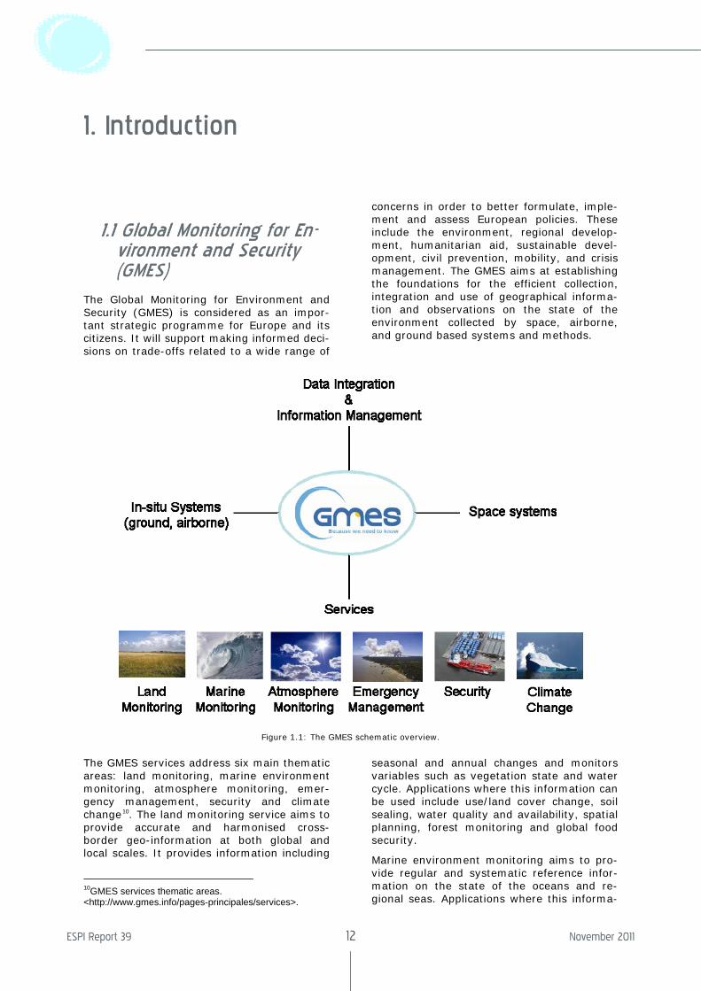
1.1 Global Monitoring for En-vironment and Security (GMES)
The Global Monitoring for Environment and Security (GMES) is considered as an impor-tant strategic programme for Europe and its citizens. It will support making informed deci-sions on trade-offs related to a wide range of
concerns in order to better formulate, imple-ment and assess European policies. These include the environment, regional develop-ment, humanitarian aid, sustainable devel-opment, civil prevention, mobility, and crisis management. The GMES aims at establishing the foundations for the efficient collection, integration and use of geographical informa-tion and observations on the state of the environment collected by space, airborne, and ground based systems and methods.
Figure 1.1: The GMES schematic overview.
The GMES services address six main thematic areas: land monitoring, marine environment monitoring, atmosphere monitoring, emer-gency management, security and climate change10. The land monitoring service aims to provide accurate and harmonised cross-border geo-information at both global and local scales. It provides information including
10GMES services thematic areas. <http://www.gmes.info/pages-principales/services>.
seasonal and annual changes and monitors variables such as vegetation state and water cycle. Applications where this information can be used include use/land cover change, soil sealing, water quality and availability, spatial planning, forest monitoring and global food security.
Marine environment monitoring aims to pro-vide regular and systematic reference infor-mation on the state of the oceans and re-gional seas. Applications where this informa-
The Socio-Economic Benefits of GMES
ESPI Report 39 13 November 2011
tion can be used are marine safety (e.g. ma-rine operations, oil spill combat, ship routing, defence, search and rescue); marine re-sources (e.g. fish stock management); ma-rine and coastal environment (e.g. water quality, pollution, coastal activities); and climate and seasonal forecasting (e.g. climate monitoring, ice survey, seasonal forecasting).
Atmosphere monitoring aims to provide data records on atmospheric composition in recent years, present conditions and to forecast the distribution of key constituents a few years ahead. It addresses greenhouse gases, reac-tive gases that influence the air we breathe, ozone layer and UV radiation, aerosols that affect temperature, air quality and transmis-sion of solar radiation.
Emergency management service, with a worldwide coverage, aims to address a wide range of emergency situations resulting from natural or man-made disasters. This covers in particular floods, forest fires, landslides, earthquakes, volcanic eruptions, and humani-tarian crises.
The security service aims to support related European Union policies in the following ar-eas: border surveillance, maritime surveil-lance and support to the EU External Action. In the area of border surveillance the objec-tives are to reduce the number of illegal im-migrants, reduce the death toll of illegal im-migrants, and to increase internal security. In maritime security the objective is to ensure safe use of the seas and secure the maritime borders of the EU. These include issues re-lated to safety of navigation, marine pollu-tion, law enforcement and overall security. GMES has a strong potential to support the EU Extensional Action Service though detec-tion and monitoring of security threats, crisis prevention, preparedness and response ca-pabilities. The EU can use GMES as a tool to assist in promoting its values for human and economic development, human rights, free-dom and democracy. The EU can assist third countries in situations of crisis or emergency management and address global and trans-regional threats (e.g. proliferation of weapons of massive destruction, nuclear and treaties monitoring).
The climate change service aims at monitor-ing each of the Earth’s different subsystems to better monitor and understand climate change. This interlinks with atmosphere monitoring, marine environment monitoring and land monitoring services.
It is anticipated that value added services are and will be developed by public and private entities, based on the basic services. Various studies have been conducted over the past decade regarding the socioeconomic benefits
of this programme in terms of the core and value added services for the various thematic areas.
1 .2 Description of the Euro-pean Earth Observation Downstream Sector
The Earth observation downstream sector (0.4 billion Euros for Europe, representing 31% of global revenue in 2005) is much smaller than that of telecommunications (18.1 billion Euro for Europe representing 33% of global revenue in 2005) and naviga-tion (2.3 billion Euro for Europe representing 13% of global revenue in 200511). European revenue from the Earth observation sector takes up of one third of global revenue mak-ing Europe one of the main players in the sector. There is no evidence that non-European companies serve a significant share of the European market i.e. import into the EU of services is believed to be non-existent12. Even though most of the Earth Observation markets are open to foreign suppliers in terms of the open competition principle, at national level there is a tendency for local providers to supply a variety of value-adding activities13. European down-stream service providers are dependent on the data suppliers. They majority of their customers are public organizations and they sell highly customized products and services.
A comparison between the European and US market shows that US industry is two to three times the size of Europe with revenues 20% higher than those of Europe. The mar-ket profiles are similar in terms of applica-tions, with the main difference being that the US has a larger domestic defence and secu-rity market than Europe and US industry appears to be growing faster than that of Europe14.
11 Euroconsult 2007. 12 ECOSYS.Study on Competiveness of the GMES down-stream Sector.European Commission Contract ENTER/06/054. 2008. 13 ECOSYS. Study on Competiveness of the GMES down-stream Sector. European Commission Contract ENTER/06/054. 2008. 14 ECOSYS. Study on Competiveness of the GMES down-stream Sector. European Commission Contract ENTER/06/054. 2008.
ESPI Report 39 14 November 2011
1 .3 Methodology
The assessment of GMES benefits presented in this report is based on: 1) the assessment of previously conducted studies by the Euro-pean Space Agency (ESA) and the European Commission; 2) desktop research; 3) consul-tation with relevant stakeholders.
Various studies have been conducted high-lighting the socioeconomic benefits of the GMES service elements (GSE). These studies make qualitative and quantitative analyses and assessments of the different sectors. Cost Benefit Analysis (CBA) is used exten-sively. CBA is a field of work with different views on approaches, metrics, assumptions, and conclusions.
Some of the studies that were used for this report include the twelve ESA GSE projects (ten in 2003 and two in 2004). The Pricewa-terhouseCoopers15 socio-economic benefits analysis of GMES in 2006 reviewed these twelve studies and with additional research
15 PricewaterhouseCoopers.Socio-Economic Benefits Analysis of GMES. ESA Contract 18868/05. 2006.
provided an analysis representing values projected in 2005. This study and those of ESA are used as a basis for the quantitative analysis in this report. Additionally each one of the ESA studies presents a qualitative analysis of other benefits. This are summa-rized and presented in this report. These studies do not cover the entire spectrum of the service elements. The Commission study “Analysis and evaluation of selected GMES projects”16, evaluates a number of GMES projects and compares them by cross-referencing different project’s data products. The projects evaluated are: Geoland, GSE Land, GSE Forest Monitoring, Marcoast, PROMOTE, TerraFirma, GEMS, MERSEA.
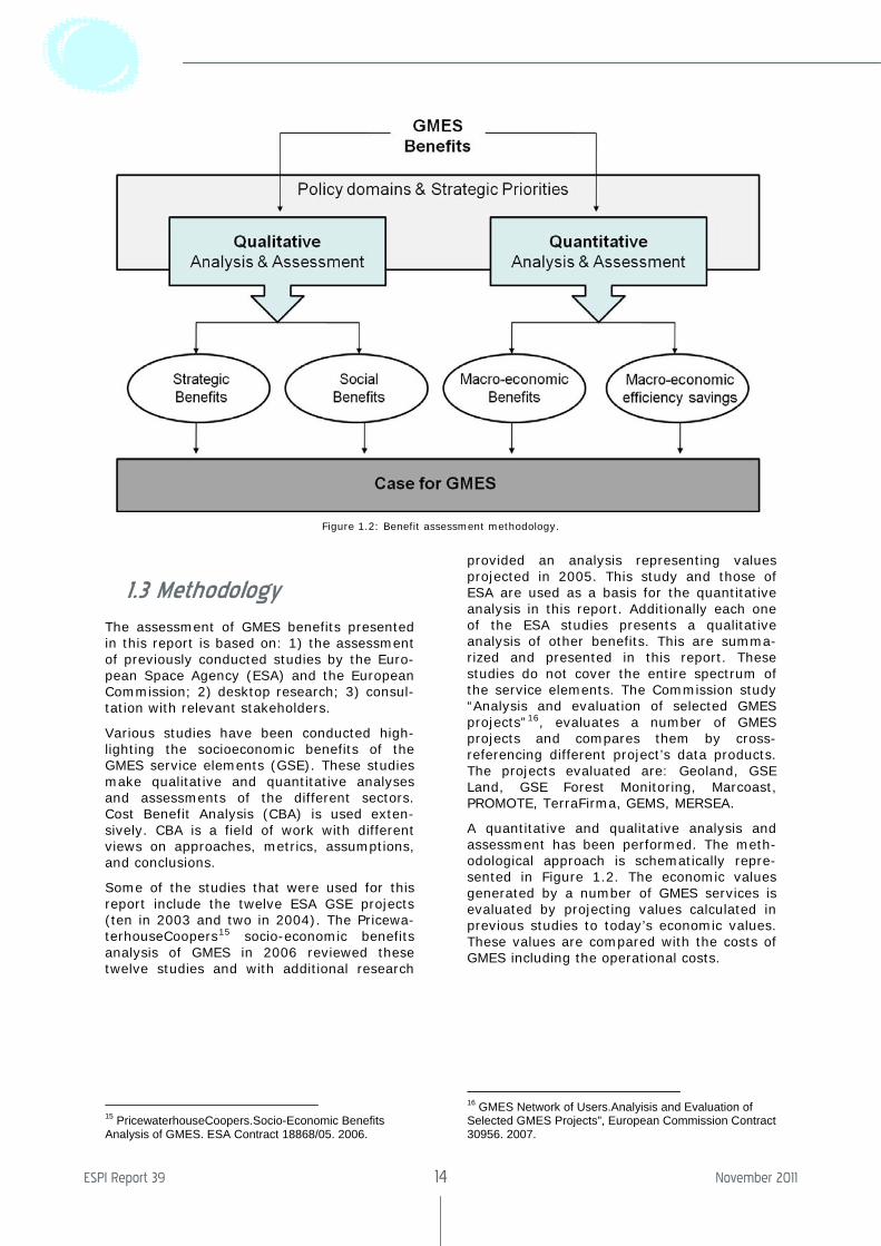
A quantitative and qualitative analysis and assessment has been performed. The meth-odological approach is schematically repre-sented in Figure 1.2. The economic values generated by a number of GMES services is evaluated by projecting values calculated in previous studies to today’s economic values. These values are compared with the costs of GMES including the operational costs.
16 GMES Network of Users.Analyisis and Evaluation of Selected GMES Projects”, European Commission Contract 30956. 2007.
Figure 1.2: Benefit assessment methodology.
The Socio-Economic Benefits of GMES
ESPI Report 39 15 November 2011
2. Natural and Man-Made Disasters
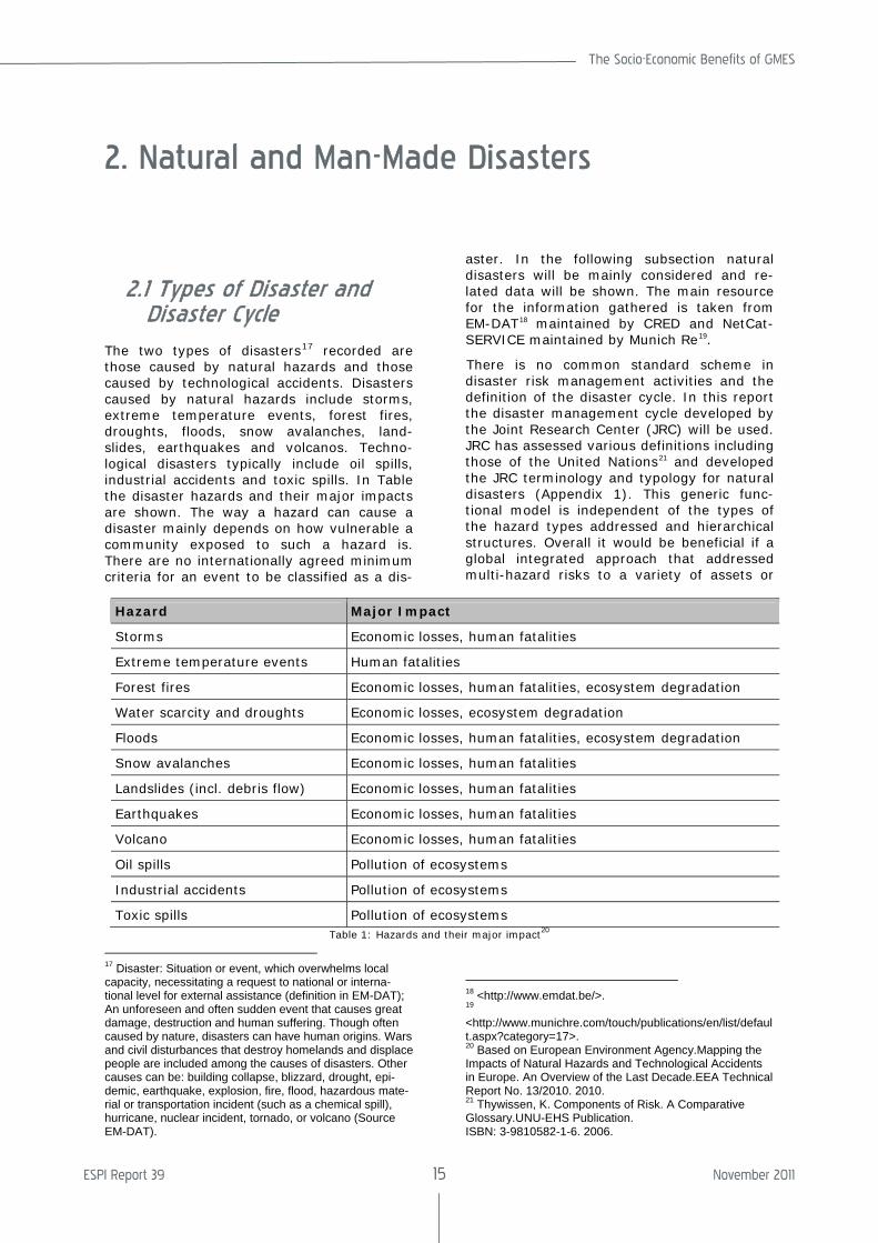
2.1 Types of Disaster and Disaster Cycle
The two types of disasters17 recorded are those caused by natural hazards and those caused by technological accidents. Disasters caused by natural hazards include storms, extreme temperature events, forest fires, droughts, floods, snow avalanches, land-slides, earthquakes and volcanos. Techno-logical disasters typically include oil spills, industrial accidents and toxic spills. In Table the disaster hazards and their major impacts are shown. The way a hazard can cause a disaster mainly depends on how vulnerable a community exposed to such a hazard is. There are no internationally agreed minimum criteria for an event to be classified as a dis-
17 Disaster: Situation or event, which overwhelms local capacity, necessitating a request to national or interna-tional level for external assistance (definition in EM-DAT); An unforeseen and often sudden event that causes great damage, destruction and human suffering. Though often caused by nature, disasters can have human origins. Wars and civil disturbances that destroy homelands and displace people are included among the causes of disasters. Other causes can be: building collapse, blizzard, drought, epi-demic, earthquake, explosion, fire, flood, hazardous mate-rial or transportation incident (such as a chemical spill), hurricane, nuclear incident, tornado, or volcano (Source EM-DAT).
aster. In the following subsection natural disasters will be mainly considered and re-lated data will be shown. The main resource for the information gathered is taken from EM-DAT18 maintained by CRED and NetCat-SERVICE maintained by Munich Re19.
There is no common standard scheme in disaster risk management activities and the definition of the disaster cycle. In this report the disaster management cycle developed by the Joint Research Center (JRC) will be used. JRC has assessed various definitions including those of the United Nations21 and developed the JRC terminology and typology for natural disasters (Appendix 1). This generic func-tional model is independent of the types of the hazard types addressed and hierarchical structures. Overall it would be beneficial if a global integrated approach that addressed multi-hazard risks to a variety of assets or
18 <http://www.emdat.be/>. 19 <http://www.munichre.com/touch/publications/en/list/default.aspx?category=17>. 20 Based on European Environment Agency.Mapping the Impacts of Natural Hazards and Technological Accidents in Europe. An Overview of the Last Decade.EEA Technical Report No. 13/2010. 2010. 21 Thywissen, K. Components of Risk. A Comparative Glossary.UNU-EHS Publication. ISBN: 3-9810582-1-6. 2006.
Hazard Major Impact
Storms Economic losses, human fatalities
Extreme temperature events Human fatalities
Forest fires Economic losses, human fatalities, ecosystem degradation
Water scarcity and droughts Economic losses, ecosystem degradation
Floods Economic losses, human fatalities, ecosystem degradation
Snow avalanches Economic losses, human fatalities
Landslides (incl. debris flow) Economic losses, human fatalities
Earthquakes Economic losses, human fatalities
Volcano Economic losses, human fatalities
Oil spills Pollution of ecosystems
Industrial accidents Pollution of ecosystems
Toxic spills Pollution of ecosystems Table 1: Hazards and their major impact20
ESPI Report 39 16 November 2011
tried to make risks due to different hazards on different communities comparable, was developed.
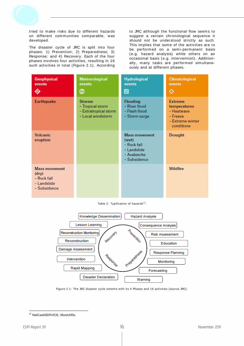
The disaster cycle of JRC is split into four phases: 1) Prevention; 2) Preparedness; 3) Response; and 4) Recovery. Each of the four phases involves four activities, resulting in 16 such activities in total (Figure 2.1). According
to JRC although the functional flow seems to suggest a certain chronological sequence it should not be understood strictly as such. This implies that some of the activities are to be performed on a semi-permanent basis (e.g. hazard analysis) while others on an occasional basis (e.g. intervention). Addition-ally, many tasks are performed simultane-ously and at different phases.
Table 2: Typification of hazards22.
Figure 2.1: The JRC disaster cycle scheme with its 4 Phases and 16 activities (source JRC).
22 NetCastSERVICE, MunichRe.
The Socio-Economic Benefits of GMES
ESPI Report 39 17 November 2011
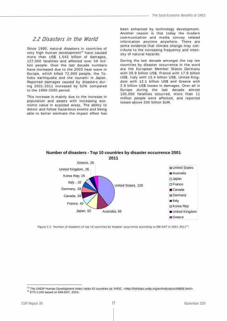
2.2 Disasters in the World
Since 1990, natural disasters in countries of very high human development23 have caused more than US$ 1,543 billion of damages, 127,000 fatalities and affected over 59 mil-lion people. Over the last decade numbers have increased due to the 2003 heat wave in Europe, which killed 72,000 people, the To-hoku earthquake and the tsunami in Japan. Reported damages caused by disasters dur-ing 2001-2011 increased by 52% compared to the 1990-2000 period.
This increase is mainly due to the increase in population and assets with increasing eco-nomic value in exposed areas. The ability to detect and follow hazardous events and being able to better estimate the impact effect has
been enhanced by technology development. Another reason is that today the modern communication and media convey related information anytime anywhere. There are some evidence that climate change may con-tribute to the increasing frequency and inten-sity of natural hazards.
During the last decade amongst the top ten countries by disaster occurrence in the word are the European Member States Germany with 29.9 billion US$, France with 17.9 billion US$, Italy with 13.4 billion US$, United King-dom with 12.1 billion US$ and Greece with 2.9 billion US$ losses in damages. Over all in Europe during the last decade almost 100,000 fatalities occurred, more than 11 million people were affected, and reported losses above 200 billion EUR.
Number of disasters - Top 10 countries by disaster occurrence 2001-2011
United States, 228
Australia, 65Japan, 62
France, 42
Canada, 34
Germany, 33
Italy , 32
Korea Rep, 26
United Kingdom, 26
Greece, 26United StatesAustraliaJapanFranceCanadaGermanyItaly Korea RepUnited KingdomGreece
Figure 2.2: Number of disasters of top 10 countries by disaster occurrence according to EM-DAT in 2001-201124.
23 The UNDP Human Development Index ranks 42 countries as VHDC. <http://hdrstats.undp.org/en/indicators/49806.html>. 24 ETC-LUSI based on EM-DAT, 2010.
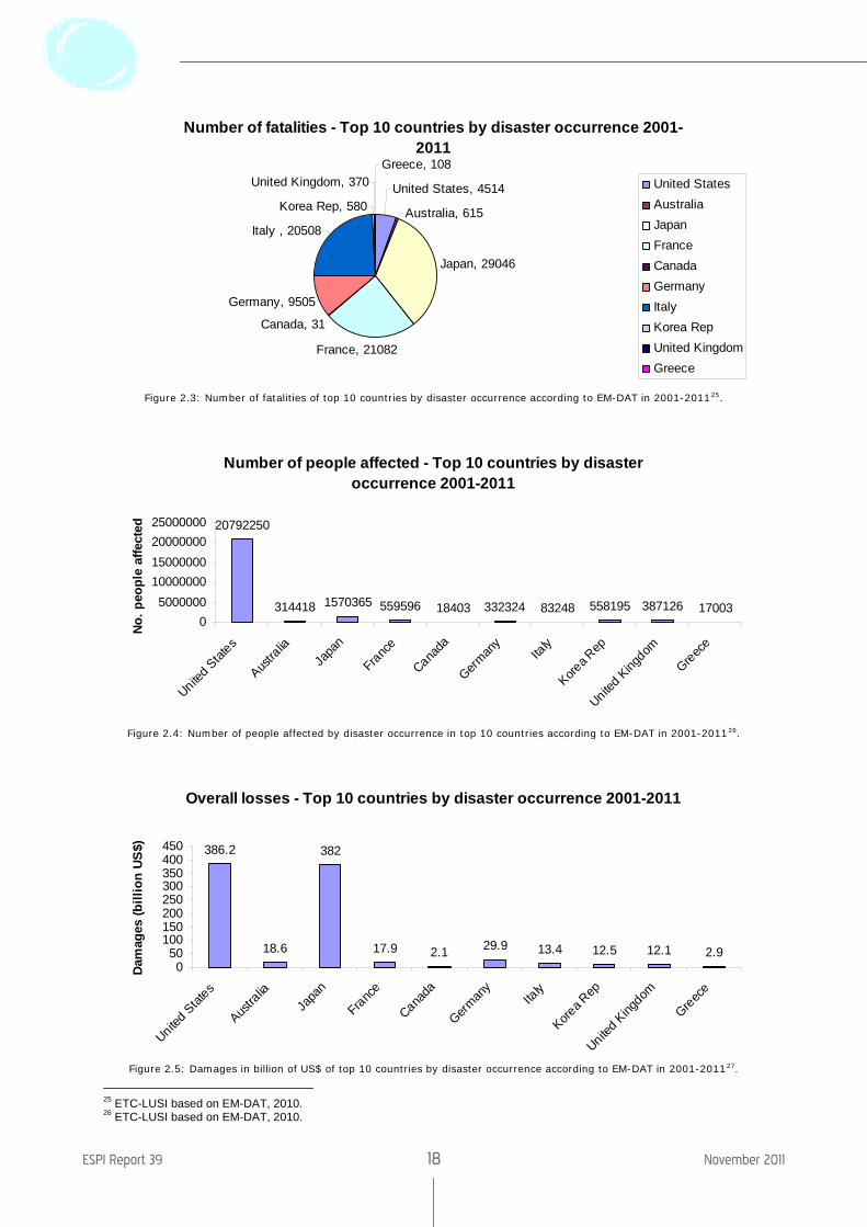
ESPI Report 39 18 November 2011
Number of fatalities - Top 10 countries by disaster occurrence 2001-2011
United States, 4514
Australia, 615
Japan, 29046
France, 21082
Canada, 31
Germany, 9505
Italy , 20508
Korea Rep, 580
United Kingdom, 370Greece, 108
United StatesAustraliaJapanFranceCanadaGermanyItaly Korea RepUnited KingdomGreece
Figure 2.3: Number of fatalities of top 10 countries by disaster occurrence according to EM-DAT in 2001-201125.
Number of people affected - Top 10 countries by disaster occurrence 2001-2011
20792250
314418 1570365 559596 18403 332324 83248 558195 387126 170030
500000010000000150000002000000025000000
United Stat
es
Austra
liaJa
pan
France
Canada
German
yIta
ly
Korea R
ep
United King
dom
Greece
No. p
eopl
e af
fect
ed
Figure 2.4: Number of people affected by disaster occurrence in top 10 countries according to EM-DAT in 2001-201126.
Overall losses - Top 10 countries by disaster occurrence 2001-2011
386.2
18.6
382
17.9 2.1 29.9 13.4 12.5 12.1 2.90
50100150200250300350400450
United Stat
es
Austra
liaJa
pan
France
Canada
German
yIta
ly
Korea R
ep
United King
dom
Greece
Dam
ages
(bill
ion
US$)
Figure 2.5: Damages in billion of US$ of top 10 countries by disaster occurrence according to EM-DAT in 2001-201127.
25 ETC-LUSI based on EM-DAT, 2010. 26 ETC-LUSI based on EM-DAT, 2010.
The Socio-Economic Benefits of GMES
ESPI Report 39 19 November 2011
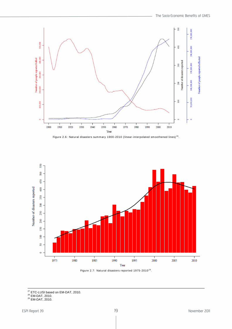
Figure 2.6: Natural disasters summary 1900-2010 (linear-interpolated smoothened lines)28.
Figure 2.7: Natural disasters reported 1975-201029.
27 ETC-LUSI based on EM-DAT, 2010. 28 EM-DAT, 2010. 29 EM-DAT, 2010.
ESPI Report 39 20 November 2011
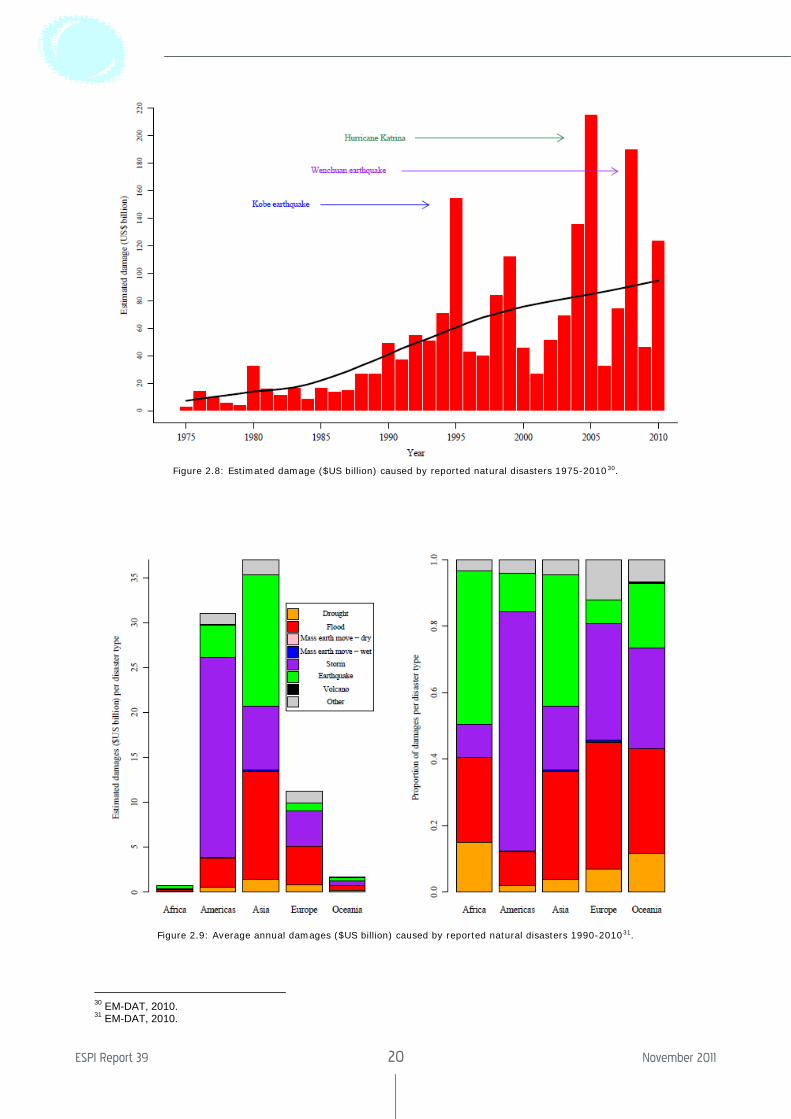
Figure 2.8: Estimated damage ($US billion) caused by reported natural disasters 1975-201030.
Figure 2.9: Average annual damages ($US billion) caused by reported natural disasters 1990-201031.
30 EM-DAT, 2010. 31 EM-DAT, 2010.
The Socio-Economic Benefits of GMES
ESPI Report 39 21 November 2011
2.3 Disasters in Europe
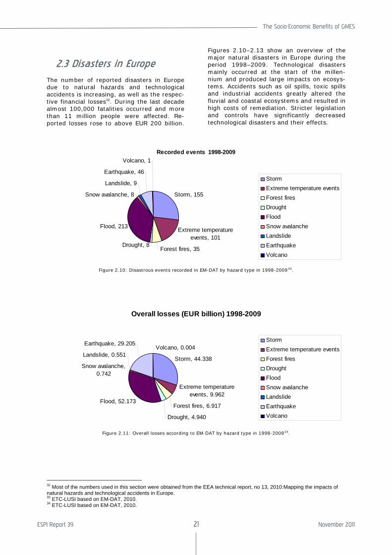
The number of reported disasters in Europe due to natural hazards and technological accidents is increasing, as well as the respec-tive financial losses32. During the last decade almost 100,000 fatalities occurred and more than 11 million people were affected. Re-ported losses rose to above EUR 200 billion.
Figures 2.10–2.13 show an overview of the major natural disasters in Europe during the period 1998–2009. Technological disasters mainly occurred at the start of the millen-nium and produced large impacts on ecosys-tems. Accidents such as oil spills, toxic spills and industrial accidents greatly altered the fluvial and coastal ecosystems and resulted in high costs of remediation. Stricter legislation and controls have significantly decreased technological disasters and their effects.
Recorded events 1998-2009
Storm, 155
Extreme temperature events, 101
Forest fires, 35Drought, 8
Flood, 213
Snow avalanche, 8
Landslide, 9
Earthquake, 46
Volcano, 1
StormExtreme temperature eventsForest firesDroughtFloodSnow avalancheLandslideEarthquakeVolcano
Figure 2.10: Disastrous events recorded in EM-DAT by hazard type in 1998-200933.
Overall losses (EUR billion) 1998-2009
Storm, 44.338
Extreme temperature events, 9.962
Forest fires, 6.917
Drought, 4.940
Flood, 52.173
Snow avalanche, 0.742
Landslide, 0.551
Earthquake, 29.205Volcano, 0.004
StormExtreme temperature eventsForest firesDroughtFloodSnow avalancheLandslideEarthquakeVolcano
Figure 2.11: Overall losses according to EM-DAT by hazard type in 1998-200934.
32 Most of the numbers used in this section were obtained from the EEA technical report, no 13, 2010:Mapping the impacts of natural hazards and technological accidents in Europe. 33 ETC-LUSI based on EM-DAT, 2010. 34 ETC-LUSI based on EM-DAT, 2010.
ESPI Report 39 22 November 2011
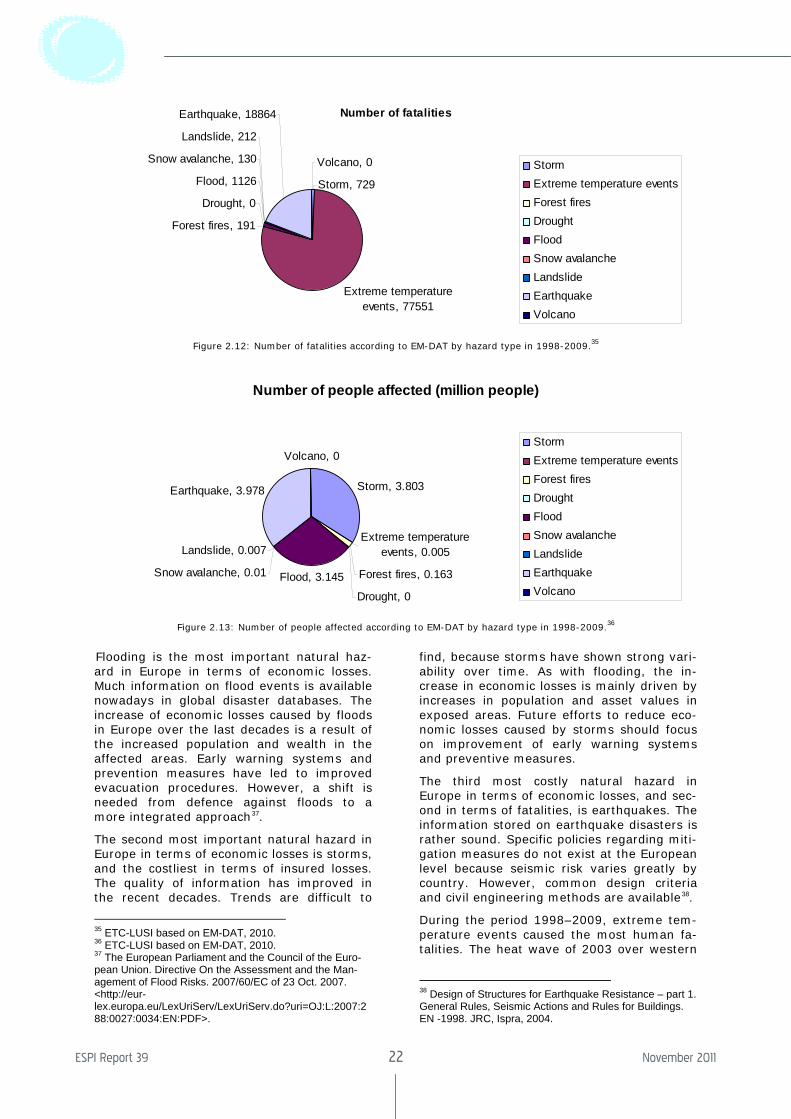
Number of fatalities
Storm, 729
Extreme temperature events, 77551
Forest fires, 191
Drought, 0
Flood, 1126
Snow avalanche, 130
Landslide, 212
Earthquake, 18864
Volcano, 0 StormExtreme temperature eventsForest firesDroughtFloodSnow avalancheLandslideEarthquakeVolcano
Figure 2.12: Number of fatalities according to EM-DAT by hazard type in 1998-2009.35
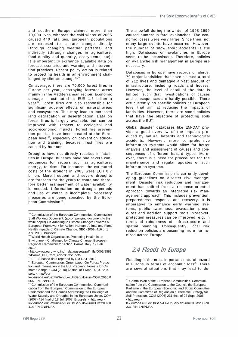
Number of people affected (million people)
Storm, 3.803
Extreme temperature events, 0.005
Forest fires, 0.163
Drought, 0
Flood, 3.145Snow avalanche, 0.01
Landslide, 0.007
Earthquake, 3.978
Volcano, 0StormExtreme temperature eventsForest firesDroughtFloodSnow avalancheLandslideEarthquakeVolcano
Figure 2.13: Number of people affected according to EM-DAT by hazard type in 1998-2009.36
3Flooding is the most important natural haz-ard in Europe in terms of economic losses. Much information on flood events is available nowadays in global disaster databases. The increase of economic losses caused by floods in Europe over the last decades is a result of the increased population and wealth in the affected areas. Early warning systems and prevention measures have led to improved evacuation procedures. However, a shift is needed from defence against floods to a more integrated approach37.
The second most important natural hazard in Europe in terms of economic losses is storms, and the costliest in terms of insured losses. The quality of information has improved in the recent decades. Trends are difficult to
35 ETC-LUSI based on EM-DAT, 2010. 36 ETC-LUSI based on EM-DAT, 2010. 37 The European Parliament and the Council of the Euro-pean Union. Directive On the Assessment and the Man-agement of Flood Risks. 2007/60/EC of 23 Oct. 2007. <http://eur-lex.europa.eu/LexUriServ/LexUriServ.do?uri=OJ:L:2007:288:0027:0034:EN:PDF>.
find, because storms have shown strong vari-ability over time. As with flooding, the in-crease in economic losses is mainly driven by increases in population and asset values in exposed areas. Future efforts to reduce eco-nomic losses caused by storms should focus on improvement of early warning systems and preventive measures.
The third most costly natural hazard in Europe in terms of economic losses, and sec-ond in terms of fatalities, is earthquakes. The information stored on earthquake disasters is rather sound. Specific policies regarding miti-gation measures do not exist at the European level because seismic risk varies greatly by country. However, common design criteria and civil engineering methods are available38.
During the period 1998–2009, extreme tem-perature events caused the most human fa-talities. The heat wave of 2003 over western
38 Design of Structures for Earthquake Resistance – part 1. General Rules, Seismic Actions and Rules for Buildings. EN -1998. JRC, Ispra, 2004.
The Socio-Economic Benefits of GMES
ESPI Report 39 23 November 2011
and southern Europe claimed more than 70,000 lives, whereas the cold winter of 2005 caused 440 fatalities. European populations are exposed to climate change directly (through changing weather patterns) and indirectly (through changes in agriculture, food quality and quantity, ecosystems, etc). It is important to exchange available data on forecast scenarios and warning and interven-tion practices. Recent policy action is related to protecting health in an environment chal-lenged by climate change39,40.
On average, there are 70,000 forest fires in Europe per year, destroying forested areas mainly in the Mediterranean region. Economic damage is estimated at EUR 1.5 billion a year41. Forest fires are also responsible for significant adverse effects on natural areas and ecosystems. This may lead to increased land degradation or desertification. Data on forest fires is largely available, but can be improved with respect to ecological and socio-economic impacts. Forest fire preven-tion policies have been created at the Euro-pean level42, especially on prevention educa-tion and training, because most fires are caused by humans.
Droughts have not directly resulted in fatali-ties in Europe, but they have had severe con-sequences for sectors such as agriculture, energy, tourism. For instance, the estimated costs of the drought in 2003 were EUR 8.7 billion. More frequent and severe droughts are foreseen for the years to come and there-fore better management of water availability is needed. Information on drought periods and use of water is incomplete. Necessary measures are being specified by the Euro-pean Commission43.
39 Commission of the European Communities. Commission Staff Working Document: (accompanying document to the white paper) On Adapting to Climate Change: Towards a European Framework for Action, Human, Animal and Plant Health Impacts of Climate Change. SEC (2009) 416 of 1 Apr. 2009. Brussels. 40 World Health Organisation. Protecting Health in an Environment Challenged by Climate Change: European Regional Framework for Action. Parma, Italy. 19 Feb. 2010. <http://www.euro.who.int/__data/assets/pdf_file/0005/95882/Parma_EH_Conf_edoc06rev1.pdf>. 41 EFFIS based data reported by EM-DAT, 2010. 42 European Commission. Green paper On Forest Protec-tion and Information in the EU: Preparing Forests for Cli-mate Change. COM (2010) 66 final of 1 Mar. 2010. Brus-sels. <http://eur-lex.europa.eu/LexUriServ/LexUriServ.do?uri=COM:2010:0066:FIN:EN:PDF>. 43 Commission of the European Communities. Communi-cation from the European Commission to the European Parliament and the Council Addressing the Challenge of Water Scarcity and Droughts in the European Union. COM (2007) 414 final of 18 Jul. 2007. Brussels. < http://eur-lex.europa.eu/LexUriServ/LexUriServ.do?uri=COM:2007:0414:FIN:EN:PDF>.
The snowfall during the winter of 1998-1999 caused numerous fatal avalanches. The eco-nomic losses were very large. Since then, not many large events have occurred. However, the number of snow sport accidents is still high. Databases on avalanches in Europe seem to be inconsistent. Therefore, policies on avalanche risk management in Europe are necessary.
Databases in Europe have records of almost 70 major landslides that have claimed a total of 212 lives and damaged a vast amount of infrastructure, including roads and houses. However, the level of detail of the data is limited, such that investigations of causes and consequences are hardly possible. There are currently no specific policies at European level that aim at reducing the impacts of landslides. However, there are some policies that have the objective of protecting soils across the EU44.
Global disaster databases like EM-DAT pro-vide a good overview of the impacts pro-duced by natural hazards and technological accidents. However, more comprehensive information systems would allow for better analysis and assessment of causes and con-sequences of different hazard types. More-over, there is a need for procedures for the maintenance and regular updates of such information systems.
The European Commission is currently devel-oping guidelines on disaster risk manage-ment. Disaster risk reduction and manage-ment has shifted from a response-oriented approach towards an integrated risk man-agement approach. This includes prevention, preparedness, response and recovery. It is imperative to enhance early warning sys-tems, public awareness, evacuation proce-dures and decision support tools. Moreover, protection measures can be improved, e.g. in terms of robustness of infrastructure and spatial planning. Consequently, local risk reduction policies are becoming more harmo-nized across Europe.
2.4 Floods in Europe
Flooding is the most important natural hazard in Europe in terms of economic loss45. There are several situations that may lead to de-
44 Commission of the European Communities. Communi-cation from the Commission to the Council, the European Parliament, the European Economic and Social Committee and the Committee of Regions on a Thematic Strategy for Soil Protection. COM (2006) 231 final of 22 Sept. 2006. <http://eur-lex.europa.eu/LexUriServ/LexUriServ.do?uri=COM:2006:0231:FIN:EN:PDF>.

ESPI Report 39 24 November 2011
structive abundance of water. River floods are caused by intensive and long-lasting pre-cipitation, fast snow-melt, storms, and tech-nology related failures such as dam breaks. Several severe flooding events have occurred in Europe during the last decade. They re-
45 Centre for Research on the Epidemiology of Disasters (CRED). Disaster data: a Balanced Perspective. CRED Crunch. Issue no. 17. Mar. 2007. Brussels.
sulted in over 1,100 fatalities (see Figure 2.12) and affected more than 3 million people in the period 1998–2009 (see Figure 2.13). The most significant flood disasters are listed46 in Table 3.
46 European Environment Agency (EEA) Mapping the Impacts of Natural Hazards and Technological Accidents in Europe. EEA Technical Report 13. 2010: 66 - 68. < www.eea.europa.eu/publications/mapping-the-impacts-of-natural/>.

The Socio-Economic Benefits of GMES
ESPI Report 39 25 November 2011
ESPI Report 39 26 November 2011
Table 3: Significant flood disasters in Europe 1998-2009.
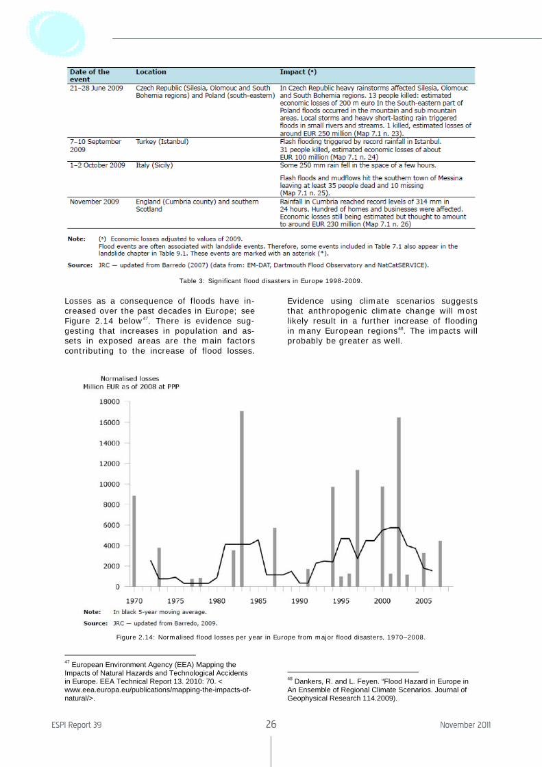
Losses as a consequence of floods have in-creased over the past decades in Europe; see Figure 2.14 below47. There is evidence sug-gesting that increases in population and as-sets in exposed areas are the main factors contributing to the increase of flood losses.
47 European Environment Agency (EEA) Mapping the Impacts of Natural Hazards and Technological Accidents in Europe. EEA Technical Report 13. 2010: 70. < www.eea.europa.eu/publications/mapping-the-impacts-of-natural/>.
Evidence using climate scenarios suggests that anthropogenic climate change will most likely result in a further increase of flooding in many European regions48. The impacts will probably be greater as well.
48 Dankers, R. and L. Feyen. “Flood Hazard in Europe in An Ensemble of Regional Climate Scenarios. Journal of Geophysical Research 114.2009).
Figure 2.14: Normalised flood losses per year in Europe from major flood disasters, 1970–2008.
The Socio-Economic Benefits of GMES
ESPI Report 39 27 November 2011
To protect against floods, technical infrastruc-ture, such as structural flood defences (dams), storage reservoirs and embank-ments, are built. Increasing awareness in Europe that floods are a significant threat to the well-being of the population, prompted the European Commission to initiate the de-velopment of a European Flood Awareness System (EFAS) in 2003. The EFAS system should be able to provide pre-alerts for the transnational river basins in Europe, and thus raise preparedness prior to a possible upcom-ing flood event. Nevertheless, for an inte-grated flood risk management process, pro-tection and preparedness have to be com-plemented by prevention, response and re-covery systems. Avoiding development in flood-prone areas, adapting future develop-ments to the risk of flooding, improving pro-tection measures and promoting appropriate land-use, agricultural and forestry practices are all necessary in the short term.
Specific flood prevention policies exist in many European countries and at the Euro-pean level there is the directive on the as-sessment and management of flood risks49. The directive aims at reducing the risks and adverse consequences and will be imple-mented in Member States in three stages, starting with a preliminary flood risk assess-
49 European Parliament and the Council. Directive 2007/60/EC of the European Parliament and of the Council of 23 Oct. 2007 On the Assessment and the Management of Flood Risks.
ment, followed by the development of flood hazard and risk maps for flood-prone zones, and then flood risk management plans. A European early warning system (EFAS) has been developed by JRC as a complementary information system to those of the Member States.
2.4.1 European Early Warning Systems
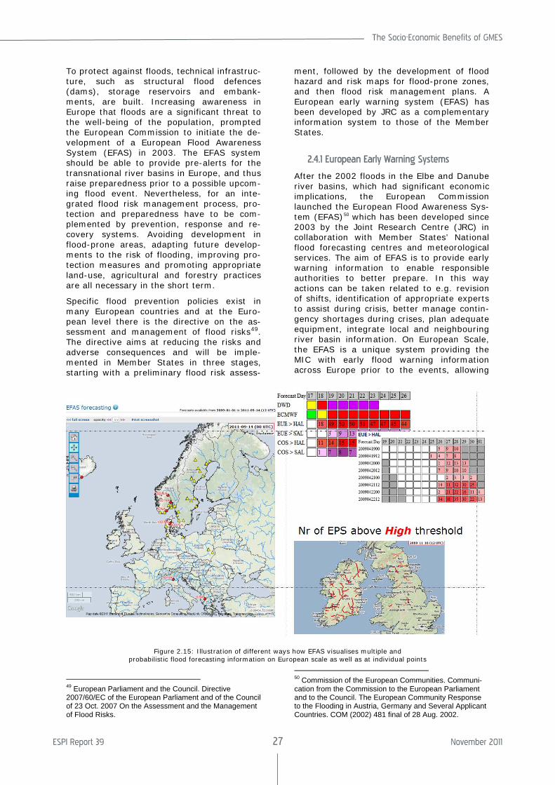
After the 2002 floods in the Elbe and Danube river basins, which had significant economic implications, the European Commission launched the European Flood Awareness Sys-tem (EFAS)50 which has been developed since 2003 by the Joint Research Centre (JRC) in collaboration with Member States’ National flood forecasting centres and meteorological services. The aim of EFAS is to provide early warning information to enable responsible authorities to better prepare. In this way actions can be taken related to e.g. revision of shifts, identification of appropriate experts to assist during crisis, better manage contin-gency shortages during crises, plan adequate equipment, integrate local and neighbouring river basin information. On European Scale, the EFAS is a unique system providing the MIC with early flood warning information across Europe prior to the events, allowing
50 Commission of the European Communities. Communi-cation from the Commission to the European Parliament and to the Council. The European Community Response to the Flooding in Austria, Germany and Several Applicant Countries. COM (2002) 481 final of 28 Aug. 2002.
Figure 2.15: Illustration of different ways how EFAS visualises multiple and probabilistic flood forecasting information on European scale as well as at individual points
ESPI Report 39 28 November 2011
the MIC to be prepared in case a country requests aid. On the national level. EFAS provides complementary information to the national systems, e.g. catchment based in-formation that contributes to better prepar-edness and shorter reaction times when needed. EFAS can provide up to 10 days early warning. This lead-time can only be achieved when using multiple, medium-range weather forecasts as inputs. This information is designed to be complementary to that of national operational flood forecasting infor-mation.
EFAS uses inputs from several weather cen-tres and several types of forecasts with lead-times varying from 5 to 15 days. This infor-mation is integrated into the hydrological model and the outputs are processed and made available on the flood portal. These can be accessed via a password-protected web-page by currently 31 partner organizations across Europe. The information is updated twice a day51.
51 European Commission. Joint Research Centre. EFAS-IS Portal. <http://efas-is.jrc.ec.europa.eu/>.
2.5 Forest Fires in Europe
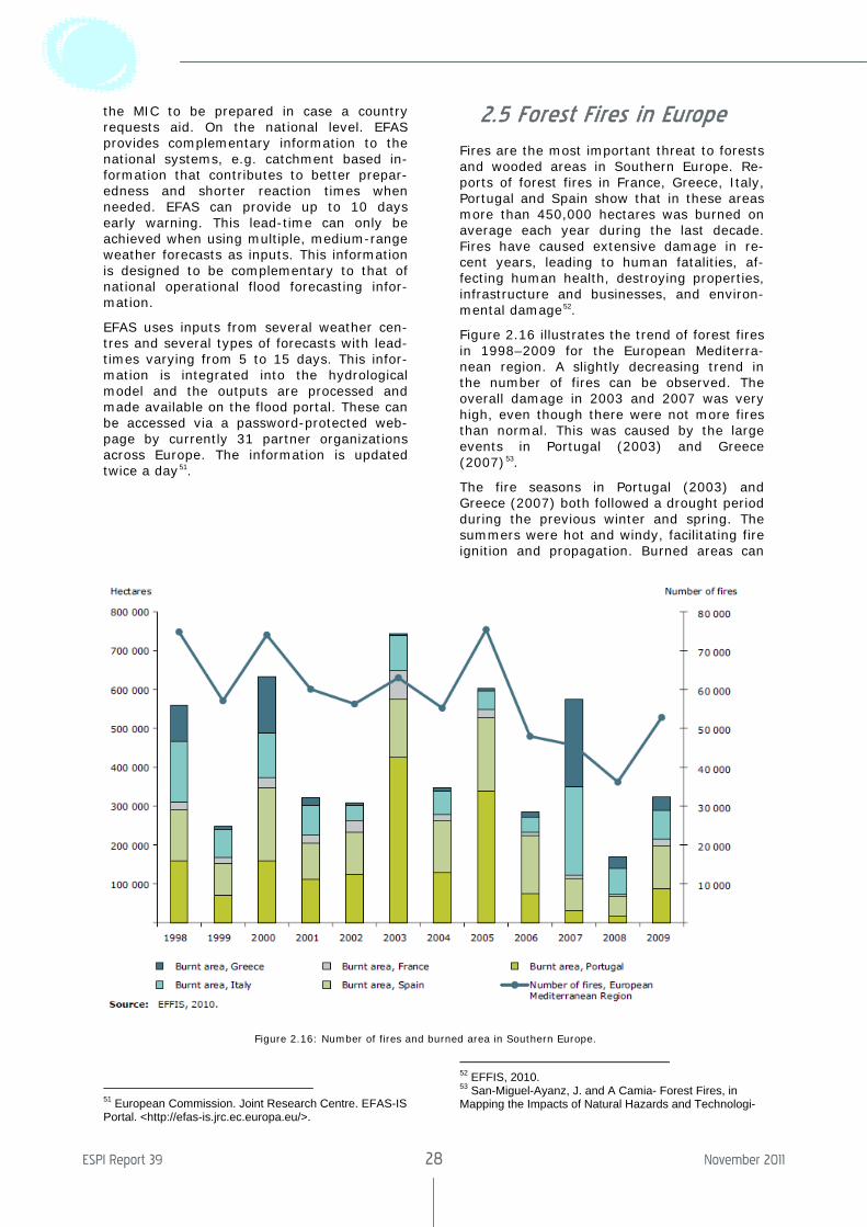
Fires are the most important threat to forests and wooded areas in Southern Europe. Re-ports of forest fires in France, Greece, Italy, Portugal and Spain show that in these areas more than 450,000 hectares was burned on average each year during the last decade. Fires have caused extensive damage in re-cent years, leading to human fatalities, af-fecting human health, destroying properties, infrastructure and businesses, and environ-mental damage52.
Figure 2.16 illustrates the trend of forest fires in 1998–2009 for the European Mediterra-nean region. A slightly decreasing trend in the number of fires can be observed. The overall damage in 2003 and 2007 was very high, even though there were not more fires than normal. This was caused by the large events in Portugal (2003) and Greece (2007)53.
The fire seasons in Portugal (2003) and Greece (2007) both followed a drought period during the previous winter and spring. The summers were hot and windy, facilitating fire ignition and propagation. Burned areas can
52 EFFIS, 2010. 53 San-Miguel-Ayanz, J. and A Camia- Forest Fires, in Mapping the Impacts of Natural Hazards and Technologi-
Figure 2.16: Number of fires and burned area in Southern Europe.
The Socio-Economic Benefits of GMES
ESPI Report 39 29 November 2011
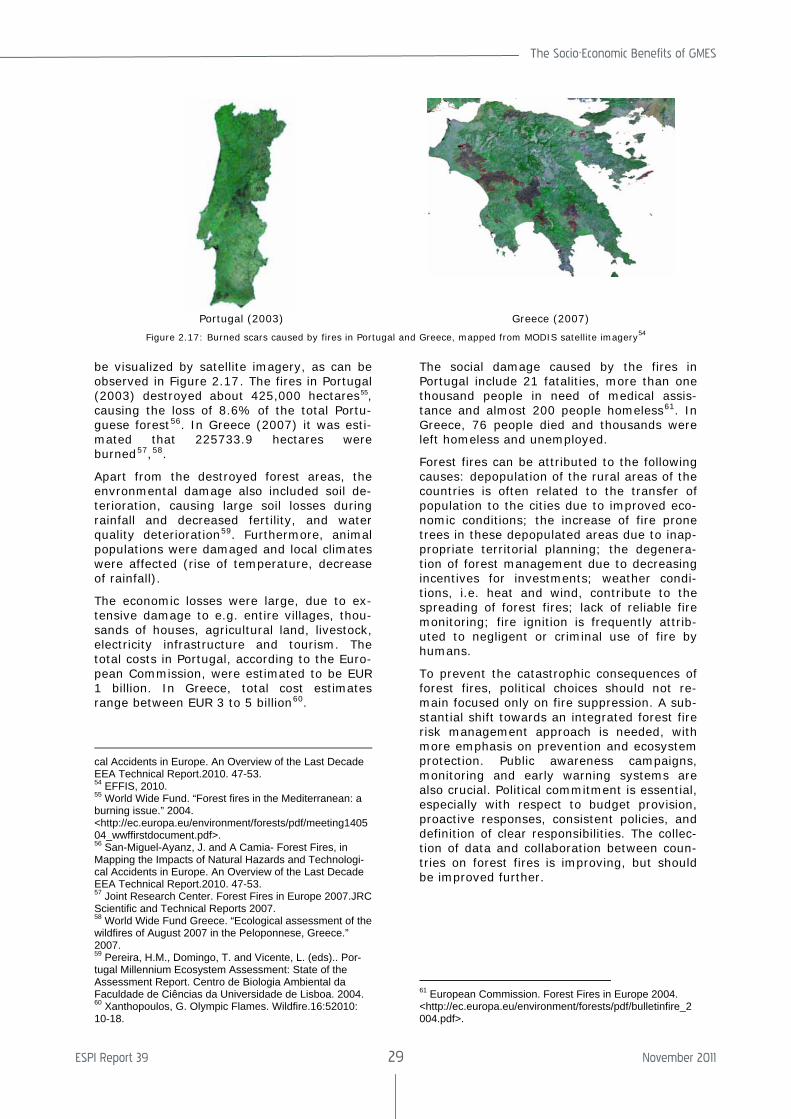
be visualized by satellite imagery, as can be observed in Figure 2.17. The fires in Portugal (2003) destroyed about 425,000 hectares55, causing the loss of 8.6% of the total Portu-guese forest56. In Greece (2007) it was esti-mated that 225733.9 hectares were burned57,58.
Apart from the destroyed forest areas, the envronmental damage also included soil de-terioration, causing large soil losses during rainfall and decreased fertility, and water quality deterioration59. Furthermore, animal populations were damaged and local climates were affected (rise of temperature, decrease of rainfall).
The economic losses were large, due to ex-tensive damage to e.g. entire villages, thou-sands of houses, agricultural land, livestock, electricity infrastructure and tourism. The total costs in Portugal, according to the Euro-pean Commission, were estimated to be EUR 1 billion. In Greece, total cost estimates range between EUR 3 to 5 billion60.
cal Accidents in Europe. An Overview of the Last Decade EEA Technical Report.2010. 47-53. 54 EFFIS, 2010. 55 World Wide Fund. “Forest fires in the Mediterranean: a burning issue.” 2004. <http://ec.europa.eu/environment/forests/pdf/meeting140504_wwffirstdocument.pdf>. 56 San-Miguel-Ayanz, J. and A Camia- Forest Fires, in Mapping the Impacts of Natural Hazards and Technologi-cal Accidents in Europe. An Overview of the Last Decade EEA Technical Report.2010. 47-53. 57 Joint Research Center. Forest Fires in Europe 2007.JRC Scientific and Technical Reports 2007. 58 World Wide Fund Greece. “Ecological assessment of the wildfires of August 2007 in the Peloponnese, Greece.” 2007. 59 Pereira, H.M., Domingo, T. and Vicente, L. (eds).. Por-tugal Millennium Ecosystem Assessment: State of the Assessment Report. Centro de Biologia Ambiental da Faculdade de Ciências da Universidade de Lisboa. 2004. 60 Xanthopoulos, G. Olympic Flames. Wildfire.16:52010: 10-18.
The social damage caused by the fires in Portugal include 21 fatalities, more than one thousand people in need of medical assis-tance and almost 200 people homeless61. In Greece, 76 people died and thousands were left homeless and unemployed.
Forest fires can be attributed to the following causes: depopulation of the rural areas of the countries is often related to the transfer of population to the cities due to improved eco-nomic conditions; the increase of fire prone trees in these depopulated areas due to inap-propriate territorial planning; the degenera-tion of forest management due to decreasing incentives for investments; weather condi-tions, i.e. heat and wind, contribute to the spreading of forest fires; lack of reliable fire monitoring; fire ignition is frequently attrib-uted to negligent or criminal use of fire by humans.
To prevent the catastrophic consequences of forest fires, political choices should not re-main focused only on fire suppression. A sub-stantial shift towards an integrated forest fire risk management approach is needed, with more emphasis on prevention and ecosystem protection. Public awareness campaigns, monitoring and early warning systems are also crucial. Political commitment is essential, especially with respect to budget provision, proactive responses, consistent policies, and definition of clear responsibilities. The collec-tion of data and collaboration between coun-tries on forest fires is improving, but should be improved further.
61 European Commission. Forest Fires in Europe 2004. <http://ec.europa.eu/environment/forests/pdf/bulletinfire_2004.pdf>.
Portugal (2003) Greece (2007)
Figure 2.17: Burned scars caused by fires in Portugal and Greece, mapped from MODIS satellite imagery54
ESPI Report 39 30 November 2011
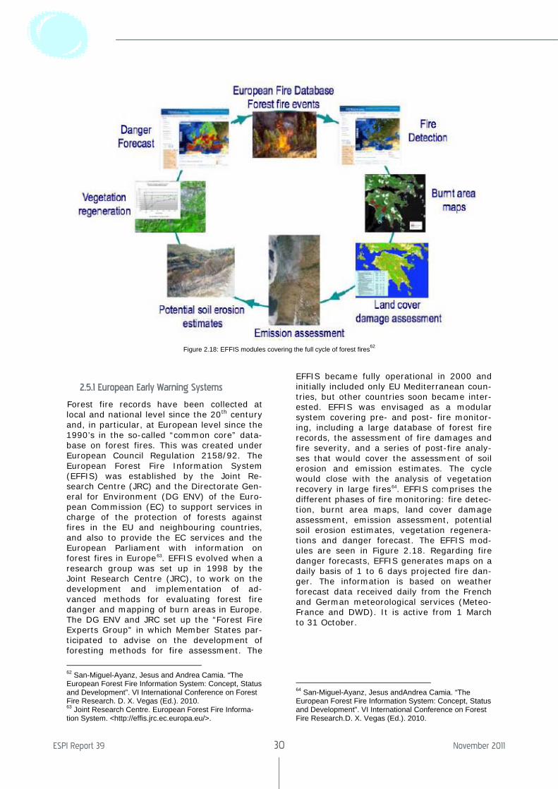
2.5.1 European Early Warning Systems
Forest fire records have been collected at local and national level since the 20th century and, in particular, at European level since the 1990’s in the so-called “common core” data-base on forest fires. This was created under European Council Regulation 2158/92. The European Forest Fire Information System (EFFIS) was established by the Joint Re-search Centre (JRC) and the Directorate Gen-eral for Environment (DG ENV) of the Euro-pean Commission (EC) to support services in charge of the protection of forests against fires in the EU and neighbouring countries, and also to provide the EC services and the European Parliament with information on forest fires in Europe63. EFFIS evolved when a research group was set up in 1998 by the Joint Research Centre (JRC), to work on the development and implementation of ad-vanced methods for evaluating forest fire danger and mapping of burn areas in Europe. The DG ENV and JRC set up the “Forest Fire Experts Group” in which Member States par-ticipated to advise on the development of foresting methods for fire assessment. The
62 San-Miguel-Ayanz, Jesus and Andrea Camia. “The European Forest Fire Information System: Concept, Status and Development”. VI International Conference on Forest Fire Research. D. X. Vegas (Ed.). 2010. 63 Joint Research Centre. European Forest Fire Informa-tion System. <http://effis.jrc.ec.europa.eu/>.
EFFIS became fully operational in 2000 and initially included only EU Mediterranean coun-tries, but other countries soon became inter-ested. EFFIS was envisaged as a modular system covering pre- and post- fire monitor-ing, including a large database of forest fire records, the assessment of fire damages and fire severity, and a series of post-fire analy-ses that would cover the assessment of soil erosion and emission estimates. The cycle would close with the analysis of vegetation recovery in large fires64. EFFIS comprises the different phases of fire monitoring: fire detec-tion, burnt area maps, land cover damage assessment, emission assessment, potential soil erosion estimates, vegetation regenera-tions and danger forecast. The EFFIS mod-ules are seen in Figure 2.18. Regarding fire danger forecasts, EFFIS generates maps on a daily basis of 1 to 6 days projected fire dan-ger. The information is based on weather forecast data received daily from the French and German meteorological services (Meteo-France and DWD). It is active from 1 March to 31 October.
64 San-Miguel-Ayanz, Jesus andAndrea Camia. “The European Forest Fire Information System: Concept, Status and Development”. VI International Conference on Forest Fire Research.D. X. Vegas (Ed.). 2010.
Figure 2.18: EFFIS modules covering the full cycle of forest fires62
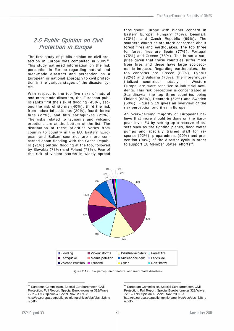
The Socio-Economic Benefits of GMES
ESPI Report 39 31 November 2011
2.6 Public Opinion on Civil Protection in Europe
The first study of public opinion on civil pro-tection in Europe was completed in 200965. This study gathered information on the risk perception in Europe regarding natural and man-made disasters and perception on a European or national approach to civil protec-tion in the various stages of the disaster cy-cle.
With respect to the top five risks of natural and man-made disasters, the European pub-lic ranks first the risk of flooding (45%), sec-ond the risk of storms (40%), third the risk from industrial accidents (29%), fourth forest fires (27%), and fifth earthquakes (22%). The risks related to tsunamis and volcanic eruptions are at the bottom of the list. The distribution of these priorities varies from country to country in the EU. Eastern Euro-pean and Balkan countries are more con-cerned about flooding with the Czech Repub-lic (91%) putting flooding at the top, followed by Slovakia (78%) and Poland (73%). Fear of the risk of violent storms is widely spread
65 European Commission. Special Eurobarometer. Civil Protection. Full Report. Special Eurobarometer 328/Wave 72.2 – TNS Opinion & Social. Nov. 2009. < http://ec.europa.eu/public_opinion/archives/ebs/ebs_328_en.pdf>.
throughout Europe with higher concern in Eastern Europe: Hungary (75%), Denmark (73%), and Czech Republic (69%). The southern countries are more concerned about forest fires and earthquakes. The top three for forest fires are Spain (77%), Portugal (75%) and Greece (75%). This is not a sur-prise given that these countries suffer most from fires and these have large socioeco-nomic impacts. Regarding earthquakes, the top concerns are Greece (88%), Cyprus (82%) and Bulgaria (76%). The more indus-trialized countries, notably in Western Europe, are more sensitive to industrial acci-dents. This risk perception is concentrated in Scandinavia, the top three countries being Finland (63%), Denmark (52%) and Sweden (50%). Figure 2.19 gives an overview of the risk perception priorities in Europe.
An overwhelming majority of Europeans be-lieve that more should be done on the Euro-pean level EU by setting up a reserve of as-sets such as fire fighting planes, flood water pumps and specially trained staff for re-sponse (92%), preparedness (90%) and pre-vention (90%) of the disaster cycle in order to support EU Member States’ efforts66.
66 European Commission. Special Eurobarometer. Civil Protection. Full Report. Special Eurobarometer 328/Wave 72.2 – TNS Opinion & Social. Nov. 2009. < http://ec.europa.eu/public_opinion/archives/ebs/ebs_328_en.pdf>.
45%
40%
29%
27%
22%
20%
16%7%
2%
1% 1%
2%
Flooding Violent storms Industrial accident Forest fireEarthquake Marine pollution Nuclear accident LandslideVolcano eruption Tsunami Other Don't know
Figure 2.19: Risk perception of natural and man-made disasters
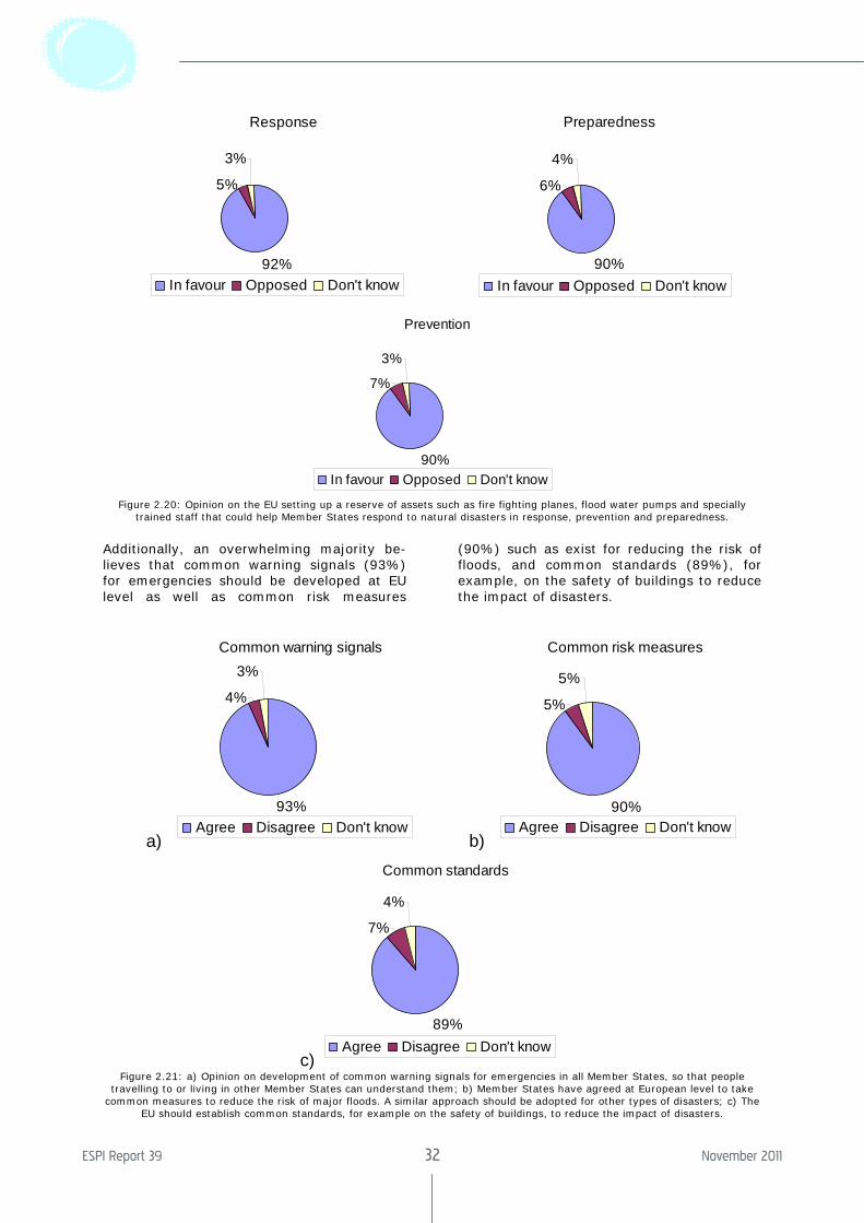
ESPI Report 39 32 November 2011
Response
92%
5%
3%
In favour Opposed Don't know
Preparedness
90%
6%
4%
In favour Opposed Don't know
Prevention
90%
7%
3%
In favour Opposed Don't know
Figure 2.20: Opinion on the EU setting up a reserve of assets such as fire fighting planes, flood water pumps and specially trained staff that could help Member States respond to natural disasters in response, prevention and preparedness.
Additionally, an overwhelming majority be-lieves that common warning signals (93%) for emergencies should be developed at EU level as well as common risk measures
(90%) such as exist for reducing the risk of floods, and common standards (89%), for example, on the safety of buildings to reduce the impact of disasters.
a)
Common warning signals
93%
4%
3%
Agree Disagree Don't know b)
Common risk measures
90%
5%
5%
Agree Disagree Don't know
c)
Common standards
89%
7%
4%
Agree Disagree Don't know
Figure 2.21: a) Opinion on development of common warning signals for emergencies in all Member States, so that people travelling to or living in other Member States can understand them; b) Member States have agreed at European level to take
common measures to reduce the risk of major floods. A similar approach should be adopted for other types of disasters; c) The EU should establish common standards, for example on the safety of buildings, to reduce the impact of disasters.
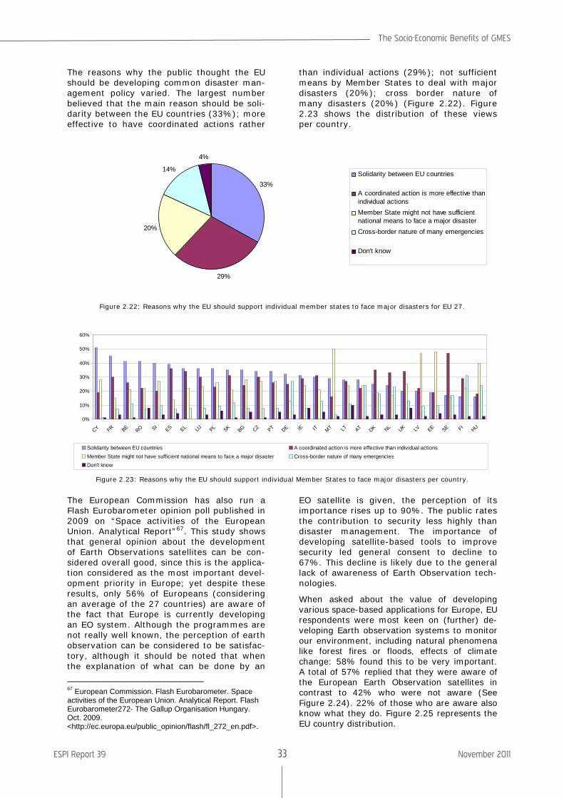
The Socio-Economic Benefits of GMES
ESPI Report 39 33 November 2011
The reasons why the public thought the EU should be developing common disaster man-agement policy varied. The largest number believed that the main reason should be soli-darity between the EU countries (33%); more effective to have coordinated actions rather
than individual actions (29%); not sufficient means by Member States to deal with major disasters (20%); cross border nature of many disasters (20%) (Figure 2.22). Figure 2.23 shows the distribution of these views per country.
33%
29%
20%
14%
4%
Solidarity between EU countries
A coordinated action is more effective thanindividual actionsMember State might not have sufficientnational means to face a major disasterCross-border nature of many emergencies
Don't know
Figure 2.22: Reasons why the EU should support individual member states to face major disasters for EU 27.
0%
10%
20%
30%
40%
50%
60%
CY FR BE RO SIES EL LU PL SK BG CZ PT DE IE IT MT LT AT DK NL UK LV EE SE FI
HU
Solidarity between EU countries A coordinated action is more effective than individual actionsMember State might not have sufficient national means to face a major disaster Cross-border nature of many emergenciesDon't know
Figure 2.23: Reasons why the EU should support individual Member States to face major disasters per country.
The European Commission has also run a Flash Eurobarometer opinion poll published in 2009 on “Space activities of the European Union. Analytical Report”67. This study shows that general opinion about the development of Earth Observations satellites can be con-sidered overall good, since this is the applica-tion considered as the most important devel-opment priority in Europe; yet despite these results, only 56% of Europeans (considering an average of the 27 countries) are aware of the fact that Europe is currently developing an EO system. Although the programmes are not really well known, the perception of earth observation can be considered to be satisfac-tory, although it should be noted that when the explanation of what can be done by an
67 European Commission. Flash Eurobarometer. Space activities of the European Union. Analytical Report. Flash Eurobarometer272- The Gallup Organisation Hungary. Oct. 2009. <http://ec.europa.eu/public_opinion/flash/fl_272_en.pdf>.
EO satellite is given, the perception of its importance rises up to 90%. The public rates the contribution to security less highly than disaster management. The importance of developing satellite-based tools to improve security led general consent to decline to 67%. This decline is likely due to the general lack of awareness of Earth Observation tech-nologies.
When asked about the value of developing various space-based applications for Europe, EU respondents were most keen on (further) de-veloping Earth observation systems to monitor our environment, including natural phenomena like forest fires or floods, effects of climate change: 58% found this to be very important. A total of 57% replied that they were aware of the European Earth Observation satellites in contrast to 42% who were not aware (See Figure 2.24). 22% of those who are aware also know what they do. Figure 2.25 represents the EU country distribution.
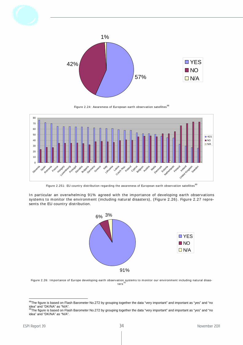
ESPI Report 39 34 November 2011
57%
42%
1%
YESNON/A
Figure 2.24: Awareness of European earth observation satellites68
0
10
20
30
40
50
60
70
80
Sloven
ia
Spain
Roman
ia
France
Hunga
ry
Luxe
mbourg
Portug
al
Slovak
ia
Bulgari
a
German
y
Greece
Ita
ly
Lithu
ania
Latvi
a
Czech
Rep
.
Poland
Cyprus
Belgium
Austria
Malta
Denmark
Estonia
Netherl
ands
Finlan
d
Irelan
d
United
Kingdo
m
Sweden
YESNON/A
Figure 2.251: EU country distribution regarding the awareness of European earth observation satellites69
In particular an overwhelming 91% agreed with the importance of developing earth observations systems to monitor the environment (including natural disasters), (Figure 2.26). Figure 2.27 repre-sents the EU country distribution.
91%
6% 3%
YESNON/A
Figure 2.26: Importance of Europe developing earth observation systems to monitor our environment including natural disas-
ters70
68The figure is based on Flash Barometer No.272 by grouping together the data “very important” and important as “yes” and “no idea” and “DK/NA” as “N/A”. 69The figure is based on Flash Barometer No.272 by grouping together the data “very important” and important as “yes” and “no idea” and “DK/NA” as “N/A”.
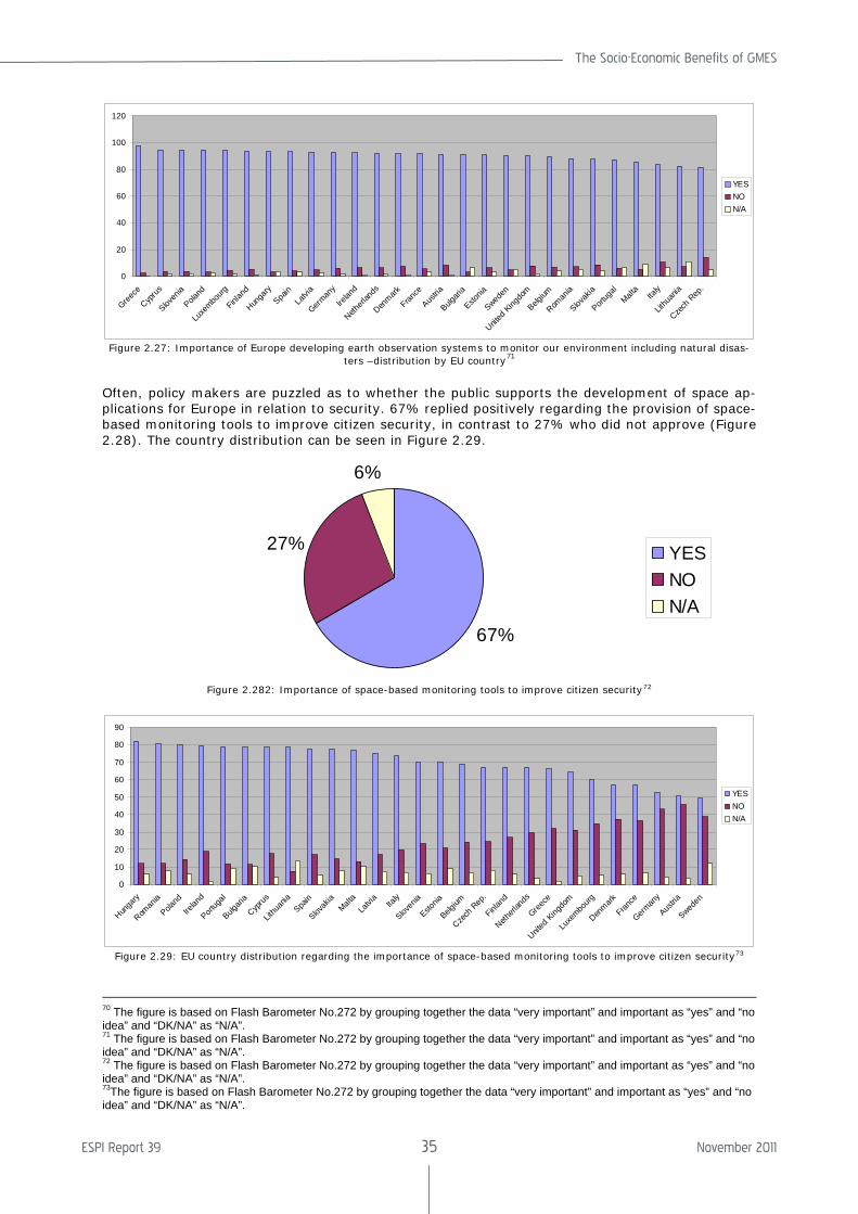
The Socio-Economic Benefits of GMES
ESPI Report 39 35 November 2011
0
20
40
60
80
100
120
Greece
Cyprus
Sloven
ia
Poland
Luxe
mbourg
Finlan
d
Hunga
ry
Spain
Latvi
a
German
y
Irelan
d
Netherl
ands
Denmark
France
Austria
Bulgari
a
Estonia
Sweden
United
King
dom
Belgium
Roman
ia
Slovak
ia
Portug
al
Malta
Italy
Lithu
ania
Czech
Rep
.
YESNON/A
Figure 2.27: Importance of Europe developing earth observation systems to monitor our environment including natural disas-
ters –distribution by EU country71
Often, policy makers are puzzled as to whether the public supports the development of space ap-plications for Europe in relation to security. 67% replied positively regarding the provision of space-based monitoring tools to improve citizen security, in contrast to 27% who did not approve (Figure 2.28). The country distribution can be seen in Figure 2.29.
67%
27%
6%
YESNON/A
Figure 2.282: Importance of space-based monitoring tools to improve citizen security72
0
10
20
30
40
50
60
70
80
90
Hunga
ry
Roman
ia
Poland
Irelan
d
Portug
al
Bulgari
a
Cyprus
Lithu
ania
Spain
Slovak
ia Malt
a
Latvi
a Ita
ly
Sloven
ia
Estonia
Belgium
Czech
Rep
.
Finlan
d
Netherl
ands
Greece
United
Kingdo
m
Luxe
mbourg
Denmark
France
German
y
Austria
Sweden
YESNON/A
Figure 2.29: EU country distribution regarding the importance of space-based monitoring tools to improve citizen security73
70 The figure is based on Flash Barometer No.272 by grouping together the data “very important” and important as “yes” and “no idea” and “DK/NA” as “N/A”. 71 The figure is based on Flash Barometer No.272 by grouping together the data “very important” and important as “yes” and “no idea” and “DK/NA” as “N/A”. 72 The figure is based on Flash Barometer No.272 by grouping together the data “very important” and important as “yes” and “no idea” and “DK/NA” as “N/A”. 73The figure is based on Flash Barometer No.272 by grouping together the data “very important” and important as “yes” and “no idea” and “DK/NA” as “N/A”.
ESPI Report 39 36 November 2011
2.7 Selected Regulatory and Policy Approaches
2.7.1 International Charter on Space and Major Disasters
The International Charter on Space and Major Disasters74 or “the Charter”, aims to provide a unified system of space data acquisition in order to deliver it to those affected by natural or man-made disasters through Authorized Users. It was initiated by the European Space Agency (ESA) and the French space agency (CNES), in consequence of the 1999 UNISPACE III Conference, with the Canadian Space Agency (CSA) signing the Charter on October 20, 2000. The Charter aims at “pro-moting cooperation between space agencies and space system operators in the use of space facilities as a contribution to the man-agement of crises arising from natural or technological disasters” (Art. II), in order to “supply during periods of crisis, to States or communities whose population, activities or property are exposed to an imminent risk, or are already victims, of natural or technologi-cal disasters, data providing a basis for criti-cal information for the anticipation and man-agement of potential crises” (paragraph 1, Art. II) and to participate “by means of this data and of the information and services re-sulting from the exploitation of space facili-ties, in the organisation of emergency assis-tance or reconstruction and subsequent op-erations” (paragraph 2, Art. II). Currently, eleven members have signed the Charter, including space agencies and international institutions75.
The International Charter can only be acti-vated by national authorized bodies from the country of the Charter member, such as civil protection, rescue, defence or security bod-ies. These authorities receive a confidential phone number that can be dialled to request the mobilization of the space and associated ground resources (RADARSAT, ERS, ENVISAT, SPOT, IRS, SAC-C, NOAA satellites,
74 Charter On Cooperation To Achieve The Coordinated Use Of Space Facilities In The Event Of Natural Or Tech-nological Disasters Rev.3 (25/4/2000).2. 75 International Charter Members (2011): European Space Agency (ESA), Centre national d'études spatiales (CNES), Canadian Space Agency (CSA), Indian Space Research Organisation (ISRO), National Oceanic and Atmospheric Administration (NOAA), Argentina's Comisión Nacional de Actividades Espaciales (CONAE), Japan Aerospace Ex-ploration Agency (JAXA), United States Geological Sur-vey (USGS), DMC International Imaging (DMC), China National Space Administration (CNSA), German Aero-space Center (DLR).
LANDSAT, ALOS, DMC satellites and others) of the member agencies to obtain the data and information needed on a disaster occur-rence. There are four different mechanisms for the user to activate the Charter76:
• Direct activation: can only be endorsed by bodies that are directly authorised to request the services of the Charter for a disaster occurring in their country or ter-ritory (Authorised Users)
• Activation via an Authorised User on be-half of a user of a non-member country: an Authorised User may request the Charter to assist a disaster management user from another country in response to a major emergency.
• Activation via the UN for UN users: The Charter has an agreement with UN OOSA and UNITAR/UNOSAT to provide support to UN agencies. These two units may submit requests on behalf of users from the United Nations.
• Activation for Asia Pacific users via Sen-tinel’s Asia partner, the Asian Disaster Reduction Centre: Sentinel Asia is a re-gional collaboration for Earth observation based emergency response in Asia Pacific countries. Since 2009 the Charter has granted the Asian Disaster Reduction Centre the right to submit activation re-quests on behalf of Sentinel Asia users.
The Charter has been activated in response to different types of hazards, such as cy-clones, oil spills, earthquakes, fires, floods and volcanic eruptions. Some examples can be provided According to the database on the activation of the Charter77 Greece has trig-gered the Charter two times. The first activa-tion was in August 2007 and the second and last time in August 2009. Portugal registered one single activation, in August 2005. The Netherlands, one of the European countries most affected by floods, does not register any activation of the Charter. Focusing on Ger-many, as another example for flooding, this country has activated this mechanism three times. The first time was in 2002, caused by flooding of the Elbe River and the second and third times were in April 2006.
76 International Charter on Space and Major Disasters activation mechanisms. <http://www.disasterscharter.org/web/charter/activate>. 77 Available at the International Charter on Space and Major Disasters website <http://www.disasterscharter.org/web/charter/activations>. 15 Sept 2011.
The Socio-Economic Benefits of GMES
ESPI Report 39 37 November 2011
2.7.2 Selected Current EU Legislation and Policy Approaches
There are several legislative and policy ap-proaches for Europe that impact the disaster cycle. The European Commission study “As-sessing the potential for a comprehensive strategy for prevention of natural and man-made disasters”78 provides an extensive over-view of EU policies, legislation and funding mechanisms and is used as the main source in this section.
The Treaty of Lisbon
The legal basis for civil protection and the environment is given in the Lisbon Treaty under TFEU Art. 6 and Art. 4 respectively. Civil protection is elaborated in Art. 196 where cooperation between Member States is encouraged in order to improve the effective-ness of systems for preventing and protecting against natural and man-made disasters. In civil protection the EU aims to:
• support and complement Member States' action at national, regional and local lev-els in risk prevention, preparing their civil protection personnel and responding to natural or man-made disasters within the EU;
• promote swift and effective operational cooperation between national civil pro-tection services within the EU
• promote consistency in international civil protection work.
Under the Lisbon Treaty the voting procedure for civil protection is based on qualified ma-jority voting. Additionally, the “solidarity clause” in Art 222 TFEU states that “the Un-ion and its Member States shall act jointly in a spirit of solidarity if a Member State is the object of … natural or man-made disasters”.
Regarding environmental protection, Art 11 TFEU states that “environmental protection requirements must be integrated into the definition and implementation of the Union’s policies and activities, in particular with a view to promoting sustainable development”. Civil protection is further elaborated in Art. 6 and Art. 176c. The basis for EU environ-mental policy is in Arts. 191-193 TFEU of the Lisbon Revision . It is a shared competence and should contribute to pursuit of the follow-ing objectives:
78 European Commission DG Environment. Assessing the Potential for a Comprehensive Community Strategy for the Prevention of Natural and manmade Disasters. Final Report. Mar. 2008. <http://ec.europa.eu/echo/civil_protection/civil/pdfdocs/stakeholders/potential_prevention_strategy.pdf>.
• preserving, protecting and improving the quality of the environment; protecting human health,
• prudent and rational utilisation of natural resources,
• promoting measures at international level to deal with regional or worldwide
• environmental problems, and in particu-lar combating climate change.
In preparation of its policy on the environ-ment the Union shall take into account
• available scientific and technical data,
• environmental conditions in the various regions of the Union,
• the potential benefits and costs of action or lack of action,
• the economic and social development of the Union as a whole and the balanced development of its regions.
Community Mechanisms for Civil Protection
The main role of the Community Mechanism for Civil Protection, which was adopted in 2007, is to facilitate reinforced cooperation between the Community and the Member States in civil protection assistance interven-tion in the event of major emergencies. The Community Mechanisms aims to cover pri-marily people but also the environment and property, including cultural heritage, in the event of natural and man-made disasters, acts of terrorism and, technological, radio-logical or environmental accidents, including accidental marine pollution, occurring inside or outside the Community, taking also into account the special needs of the isolated, outermost and other regions or islands of the Community. The Community Mechanism has several tools: the Monitoring and Information Centre (MIC), the Common Emergency and Information Systems (CECIS), a training pro-gramme and civil protection modules. In par-ticular the Monitoring and Information Centre (MIC) operated by DG ECHO, gives countries access to a platform providing available civil protection means. Also, any country outside the Union affected by a major disaster can request assistance through the MIC. The Common Emergency and Information Sys-tems (CECIS) is a web-based alert and notifi-cation application created to facilitate emer-gency communication among participating States.
ESPI Report 39 38 November 2011
Environmental Impact Assessment Directive79
The Directive applies to the assessment of the environmental effects of those public and private projects that are likely to have signifi-cant effects on the environment. It empha-sises that the best environmental policy con-sists in preventing the creation of pollution or nuisance at source and affirms the need to take effects on the environment into account at the earliest possible stage. It includes risks among the issues to be addressed as part of the impact assessment. Impacts may be on environmental media, flora and fauna but also on population and material assets.
The Directive on Strategic Environment Assess-ment80
The objective of this Directive is to provide a high level of protection of the environment and to contribute to the integration of envi-ronmental considerations into the preparation and adoption of plans and programmes with a view to promoting sustainable develop-ment, by ensuring that, in accordance with this Directive, an environmental assessment is carried out of certain plans and pro-grammes that are likely to have significant effects on the environment. It applies to a wide range of public plans and programmes (e.g. land use, transport, energy, waste, agriculture). It does not refer to policies but it is mandatory for plans/programmes that are prepared for agriculture, forestry, fisher-ies, energy, industry, transport, waste/water management, telecommunications, tourism, town & country planning or land use and which set the framework for future develop-ment approval of projects listed in the EIA Directive or that have been determined to require an assessment under the Habitats Directive.
The Environmental Liability Directive81
The Directive establishes a framework for environmental liability based on the "polluter pays" principle, with a view to preventing and
79 Council of the European Communities. Council Directive on the Assessment of the Effects of certain Public and Private Projects on the Environment. 85/ 337/ EC. < http://ec.europa.eu/environment/eia/full-legal-text/85337.htm>. 80 European Parliament and the Council of the European Union. Directive on the on the Assessment of the Effects of certain Plans and Programmes on the environment. (2001/42/EC). 27 Jun. 2001. < http://eur-lex.europa.eu/LexUriServ/LexUriServ.do?uri=OJ:L:2001:197:0030:0037:EN:PDF>. 81 The European Parliament and the Council of the Euro-pean Union. Directive on Environmental Liability with Regard to the Prevention and Remedying of Environ-mental Damage. 2004/35/EC. 21 Apr. 2004. < http://eur-lex.europa.eu/LexUriServ/LexUriServ.do?uri=OJ:L:2004:143:0056:0075:EN:PDF>.
remedying environmental damage. The pre-ventive component, however, is somewhat limited and indirect.
The EU Flood Directive82
The purpose of this Directive is to establish a framework for the assessment and manage-ment of flood risks, to reduce adverse conse-quences on human health, the environment, cultural heritage and economic activity in the Community (now the Union). It entered into force in 2007 and it requires Member States to assess which water courses and coast lines are at risk from flooding, map the flood ex-tent and assets and humans at risk in these areas, and take adequate and coordinated measures to reduce the flood risk. Addition-ally, it reinforces the right of the public to access this information and be able to par-ticipate in the planning process. This Direc-tive was developed to establish a policy framework for an integrated long term ap-proach to flood risk management, recognizing that the existing measures in the Water Framework Directive, the Civil Protection Mechanism, the EC and R&D framework pro-grammes, and the European Union Solidarity Fund (EUSF) were not sufficient to address this issue, as these instruments could not address the root causes of floods or prevent damage from happening83. The Floods Direc-tive states that flood risk management plans shall address all aspects of flood risk man-agement focusing on prevention, protection, preparedness, including flood forecasts and early warning systems and taking into ac-count the characteristics of the particular river basin or sub-basin. On European scale, the DG Joint Research Centre has developed a European Flood Awareness System (EFAS)
84 that provides early warning for floods on catchment scale to national authorities and the European Commission.
82 The European Parliament and the Council of the Euro-pean Union. Directive on the Assessment and Manage-ment of Flood Risks. 2007/60/EC. 23 Oct. 2007. <http://eur-lex.europa.eu/LexUriServ/LexUriServ.do?uri=OJ:L:2007:288:0027:0034:EN:PDF>. 83 European Commission DG Environment. Assessing the Potential for a Comprehensive Community Strategy for the Prevention of Natural and Manmade Disasters. Final Report. Mar. 2008. < http://ec.europa.eu/echo/civil_protection/civil/pdfdocs/stakeholders/potential_prevention_strategy.pdf>. 84 European Commission. Joint Research Centre. Floods Portal. <http://floods.jrc.ec.europa.eu/>.
The Socio-Economic Benefits of GMES
ESPI Report 39 39 November 2011
Seveso II Directive85
This Directive is aimed at the prevention of major-accident hazards involving dangerous substances and at limiting the consequences of any such accidents in order to protect hu-man health and the environment86.
Thematic Strategy on Soil Protection87
The Soil Thematic Strategy is a Commission Communication that aims to establish a common strategy for the protection and sus-tainable use of soil, based on the principles of integration of soil concerns into other poli-cies, preservation of soil functions within the context of sustainable use, prevention of threats to soil and mitigation of their effects, as well as restoration of rapidly degrading soils. The draft Directive aims also to address landslides and erosion88.
Thematic Strategy on the Marine Environment89
The objective of the Strategy is to protect and restore Europe’s oceans and seas and ensure that human activities are carried out in a sustainable manner so that current and future generations enjoy and benefit from biologically diverse and dynamic oceans and seas that are safe, clean, healthy and pro-ductive.
85 The European Parliament and the Council of the Euro-pean Union. Directive amending Council Directive 96/82/EC on the Control of Major-Accident Hazards involv-ing Dangerous Substances. (Seveso II). 16 Dec. 2003. < http://eur-lex.europa.eu/LexUriServ/LexUriServ.do?uri=OJ:L:2003:345:0097:0105:EN:PDF>. 86 European Commission DG Environment. Assessing the Potential for a Comprehensive Community Strategy for the Prevention of Natural and Manmade Disasters. Final Report. Mar. 2008. < http://ec.europa.eu/echo/civil_protection/civil/pdfdocs/stakeholders/potential_prevention_strategy.pdf>. 87 Commission of the European Communities. Directive Establishing a Framework for the Protection of Soil and Amending Directive 2004/35/EC.COM (2006) 232 final, 2006/0086 (COD) of 22 Sept. 2006. Brussels. < http://ec.europa.eu/environment/soil/pdf/com_2006_0232_en.pdf>. 88 European Commission DG Environment. Assessing the Potential for a Comprehensive Community Strategy for the Prevention of Natural and Manmade Disasters. Final Report. Mar. 2008. < http://ec.europa.eu/echo/civil_protection/civil/pdfdocs/stakeholders/potential_prevention_strategy.pdf>. 89 Commission of the European Communites. Communica-tion From the Commission to the Council and the Euro-pean Parliament on a Thematic Strategy on the Protection and Conservation of the Marine Environment. COM (2005) 504 final of 24 Oct. 2005. Brussels. < http://eur-lex.europa.eu/LexUriServ/LexUriServ.do?uri=COM:2005:0504:FIN:EN:PDF>.
Forestry and Wild Fires
The EU has no common forest policy as such. The Forest Focus Regulation (EC) 2152/2003, which deals with monitoring of forests and environmental interaction in the Community, established a Community scheme to monitor forest health and to prevent forest fires. Since 1998 the EC Directorate Generals Envi-ronment and Joint Research Center (JRC) have been developing the European Forest Fire Information System (EFFIS)90.
Infrastructures for Spatial Information in the European Community - INSPIRE Directive91
This directive was adopted in 2007 to lay down general rules aimed at the establish-ment of the Infrastructure for Spatial Infor-mation in the European Community, for the purposes of Community environmental poli-cies and policies or activities that may have an impact on the environment. It is based on the infrastructures for spatial information established and operated by the 27 Member States of the European Union. It addresses 34 spatial data themes92 necessary for envi-ronmental applications. In order to ensure that the spatial data infrastructures of the Member States are compatible and usable, the directive requires that common imple-menting rules (IR) are adopted in a number of specific areas, inter alia on metadata, as well as other measures to address problems regarding the availability, quality, organisa-tion, accessibility and sharing of spatial in-formation.
90 European Commission. Joint Research Centre. The European Forest Fire Information System. <http://effis.jrc.ec.europa.eu/>. 91 The European Parliament and the Council of the Euro-pean Union. Directive Establishing an Infrastructure for Spatial Information in the European Community (INSPIRE) of 14 March 2007. 2007/2/EC. 92 These themes are subdivided in the three annexes of the directive. Annex I: 1. Coordinate reference systems; 2. Geographical grid systems; 3. Geographical names; 4. Administrative units; 5. Addresses; 6. Cadastral parcels; 7. Transport networks; 8. Hydrography; 9. Protected sites. Annex II: 1. Elevation; 2. Land cover; 3. Orthoimagery; 4. Geology; Annex III: 1. Statistical units; 2. Buildings; 3. Soil; 4. Land use; 5. Human health and safety; 6. Utility and governmen-tal services; 7. Environmental monitoring Facilities; 8. Production and industrial facilities; 9. Agricultural and aquaculture facilities; 10. Population distribution and de-mography; 11. Area management/restriction/regulation zones & reporting units; 12. Natural risk zones; 13. Atmos-pheric conditions; 14. Meteorological geographical fea-tures; 15. Oceanographic geographical features; 16. Sea regions; 17. Bio-geographical regions; 18. Habitats and biotopes; 19. Species distribution; 20. Energy Resources; 21. Mineral Resources.
ESPI Report 39 40 November 2011
2.8 The Role of Satell ite Ob-servations
2.8.1 Satellite Observations and Disaster Man-agement
Efficient image analysis of satellite data can contribute to rapid mapping for disaster management. Earth observation capabilities from national, European and international sources are used to respond to major disas-ters around the world, for humanitarian aid and security. There are various mechanisms that can be initiated in case of disaster, such as the International Charter on Space and Major Disasters and the Community Mecha-nism for Civil Protection (see Section 2.7).
In case of disasters, reliance is placed on any type of geo-information that might be avail-able in a short period of time. Additionally, the appropriate information needed for action changes according to the type of the disaster and the disaster cycle phase. Thus, there is a need for a comprehensive system that pro-vides information for the various disasters and can cover all phases. Currently such a system is lacking, and GMES will be one of the most complete systems in the world pro-viding earth observation information. At the international level significant efforts are made though the Group on Earth Observation and the Global Earth Observation System of Sys-tems (GEOSS). GEOSS is an effort to inte-grate existing and future Earth observation systems in a “system of systems” in order to provide information for the benefits of soci-ety. Apart from space-based observations, GEOSS aims to incorporate in-situ and air-borne observations. The GEO is a coordina-tion group that aims to achieve comprehen-sive, coordinated and sustained Earth obser-vation and its major project is to facilitate GEOSS. GMES will be the European contribu-tion to this international endeavour.
In the case of disaster management the most important data sources are VHR optical data, thermal imagery and synthesis aperture ra-dar (SAR) systems93. Most of the commercial or research Earth-observation satellite sys-tems are optical/thermal systems. Optical data are of great importance for disaster management support such as planning the logistics of relief action in the field immedi-
93 Voigt, S., and T. Kemper, T. Riedlinger, eds.“Satellite Image Analysis for Disaster and Crisis-management Sup-port”. IEEE Transactions to Geosciences and Remote Sensing, Vol. 6. Jun. 2007.
ately after the event94. The advantage of op-tical data is that it can be interpreted easier by non-experts and can be used to give an overview of pre-disaster and post-disaster assessment, assist in search and rescue plan-ning and post-disaster reconstruction. The disadvantage is that in the event of atmos-pheric disturbances i.e. clouds, the quality of data might be inadequate. Thermal imagery offers excellent opportunities for detection of hot spots caused by fires. It gives an over-view of the extent and the number of actually burning fires and is also useful for large-scale flood monitoring i.e. the Moderate Resolution Imaging Spectroradiometer (MODIS)95,96. SAR systems are of great value for fast response mapping and analysis tasks as they allow imaging at wavelengths almost unaffected by atmospheric disturbances such as rain or cloud. This type of data is very useful in flood events, oil spills, landslides and earthquakes. The difficulty with this data is that it cannot be easily interpreted by non-experts.
Satellite-derived information needs to be used in combination with additional data to present it in a proper geospatial context for the work of civil protection agencies and re-lief organizations. It is important to generate easy-to-use maps and to incorporate data sets such as place names, the road network, rivers, critical infrastructure, and topographic information97. The most crucial problem is the availability and access to accurate and up-to-date spatial data, particularly in remote re-gions. Currently, there are still gaps in the information cycle that need to be closed to better incorporate spatial, airborne and ground data in order to have a more effective disaster management response.
2.8.2 Satellite Observations and Weather Fore-casting
Weather forecasts are part of a value chain that is embedded in the fabric of all modern economies and make an essential contribu-
94 Pesaresi, M., and A. Garhardinger,F.Haag.“Rapid Map-ping Assessment of built-up Structures using VHR Satellite Data in Tsunami Affected Areas”, Int. J. Remote Sens. 2006. 95 Brakenridge, G.R., and Carlos, H., E. Anderson. “Satel-lite Gaging Reaches: A Strategy for MODIS-based river Monitoring”. Proc. 9th Int. Symp. Remote Sens., Int, Soc. Opt., Eng., (SPIE), Crete, Greece.(2003):479-485. 96 Moderate Resolution Imaging Spectroradiometer (MODIS) is one of the instrument payloads on the TERRA satellite and AQUA satellite of NASA. The device is used to acquire data on the Earth’s surface every 1 to 2 days using 36 different spectral bands or groupings of radio wavelengths. 97 Voigt, S., and T. Kemper, T. Riedlinger, eds.“Satellite Image Analysis for Disaster and Crisis-management Sup-port”. IEEE Transactions to Geosciences and Remote Sensing, Vol. 6. Jun. 2007.
The Socio-Economic Benefits of GMES
ESPI Report 39 41 November 2011
tion to many different facets of society (e.g. protection of life and property, aviation, agri-culture, tourism, insurance, use by private individuals in their everyday decision-making).
Indeed, it is estimated that about 30% of the European economy is sensitive to weather conditions, which underscores the importance of weather forecasting information in the economic life of Europe.
Meteorological satellites have been collecting atmospheric observations for many decades and their increasing sophistication has made them an indispensible component of both weather forecasting and climate monitoring. For example, around 30% of the observations used by numerical weather forecasting mod-els are from meteorological satellites, and the absence of such data would have a very det-rimental effect on forecast accuracy.
The socio-economic benefit of this weather forecast information, which is difficult to as-sess with precision, is most easily identified at an individual application level. For exam-ple, according to Swiss Re98, storms have cost on average about 2.6 billion euros per year in Europe. If, due to preventive actions, weather forecasts enable these losses to be reduced by 10% to 50%, the corresponding gains lie between 260 and 1,200 million eu-ros per year.
A similar estimation can be made for floods. According to Barredo99 floods in Europe cost on average 4 Billion Euros per year. Assum-ing that the warning reduces losses by 10%, and if only half of the floods are forecast, the benefits from early warnings could reach 200 million Euros per year. Alternatively, if one assumes that a warning emitted 48 hours before a flood enables the overall damage to be reduced by more than 50% (Carsell100) and that 75% of the floods can be forecast, the benefits would reach 1,500 million Euros per year. Thus the combined economic bene-fit to Europe of forecasting floods and storms could lie somewhere between 460 million and 2.7 billion per year.
Estimating the value of the private use of forecasts is also not straightforward as it ultimately depends on measuring the willing-ness of users to pay for meteorological infor-mation. Lazo and colleagues have conducted
98 Swiss, Re. The Effect of Climate Change: Storm Dam-age in Europe on the Rise. 2006. <http://www.preventionweb.net/files/20629_publ06klimaveraenderungen1.pdf>. 99 Barredo.Normalised Flood Losses in Europe: 1970-2006. Nat. Hazards Earth Syst. Sci.2009. 97–104. 100 Carsell, K.M., N. D. Pingel, D.T. Ford.Quantifying the Benefit of a Flood Warning System. Nat. Hazards Rev, 5(3). 2004.131–140.
a survey of U.S. households to estimate their willingness to pay for weather information, and for the potential improvement of this information101. The survey arrived at a me-dian estimate of US$280 per year/per house-hold, with more than 80% of households ready to pay in excess of $30. Assuming that each European household is ready to pay at least 20 Euros per year, again a conservative estimate, the societal benefit from weather information for private households would be around 4 billion Euros per year. With a value of 80 Euros, the estimate reaches 15 billion Euros.
Similar estimations in other sectors that make use of forecast information (e.g. avia-tion, agriculture, energy management, for-estry, etc) suggest that the overall economic benefit to Europe of forecast information ex-ceed 8 billion Euros per year and could reach 50 billion Euros per year.
Thus, meteorological satellite observations, via their significant positive impact on fore-cast accuracy, provide a real and tangible socio-economic benefit to a wide range of applications. It is against this socio-economic backdrop that the annual European invest-ment of 300–350 million Euros in meteoro-logical satellite observations should be con-trasted.
2.8.3 Satellite Observations and Climate Moni-toring
The monitoring of climate change depends on the availability of reliable, long-term data sets. Meteorological satellite programmes, with their requirement to provide, system-atic, long-term, high quality observations for weather forecasting, are uniquely placed to also contribute to climate monitoring, with their continuous European record of meteoro-logical observations spanning from 1981 to the current day.
101 Lazo, J.K., R.E. Morss, and J.L. Demuth. “300 Billion Served: Sources, Perceptions, Uses, and Values of Weather Forecasts.” Bulletin of the American Meteorologi-cal Society. 90(6). (2009) :785-798.
ESPI Report 39 42 November 2011
3. Socio-Economic Benefits of GMES Service Elements
In this analysis the following socio-economic benefits have been identified and quantified:
3.1 Studies on Socio-Economic Benefits
Numerous studies have been conducted over the years analyzing the GMES Services Ele-ments (GSE). ESA has initiated twelve GSE projects, ten in 2003 and two in 2004. In these projects a Cost Benefits Analysis (CBA) was conducted by the project consortia, which assessed the associated cost benefits. Additionally a qualitative identification of key benefits was identified and listed in each of
these studies. In 2006 PricewaterhouseCoop-ers (PwC) completed a study for ESA aimed at looking at each one of the studies con-ducted by ESA in the previous years, analyz-ing them and from the collected information calculating the total expected socioeconomic benefits. This study has been has been fur-ther used by ESPI to translate the socioeco-nomic benefits into today’s values in section 0. In 2011 booz&co completed for the Euro-pean Commission a cost benefit analysis study with focus on the assessment of four broad funding options for GMES and its op-erational services. This study is also pre-sented and analysed in section4. Table 4 gives an overview of the studies conducted.
GSE Study Main Topic CBA Provider Year
ROSES Ocean monitoring ESYS 2004
TerraFirma Land hazard monitoring AETS 2004
GSE-FM Forest monitoring ECORYS 2004
COASTWATCH Coastal monitoring AETS 2004
AquaSoilSAGE Aqua-soil monitoring ECORYS 2004
ICEMON Sea ice monitoring ControlWare 2004
GUS (Urban Atlas) Urban Monitoring Indra 2004
GMFS Food security Monitoring ESYS 2004
NorthernView Arctic monitoring ESYS 2004
RISK-EOS Natural hazard monitoring –floods & fires
AETS 2005
RESPOND Humanitarian aid ControlWare 2005
PROMOTE Atmospheric monitoring ControlWare 2006
Socio-Economic Benefits Analysis of GMES
Assessment of previous studies and evaluation of total benefits
PricewaterhouseCoopers (PwC)
2006
Cost-Benefit Analysis for GMES
evaluation of total benefits booz&co. 2011
Table 4: Socio-economic benefits studies on GMES Service Elements.
3.1.1 Coastal Monitoring
In 2004 the ESA initiated cost benefit analy-sis (CBA) study of the service portfolio of CostWatch was completed102. CoastWatch is 102 AETS.COASTWATCH Cost Benefit Analysis for Service Portfolio.ESA Contract 17065/03/I-LG. 2004.
an information service for the coastal man-agement community that makes best use of processed satellite data. It started in 2003 and supports European policies regulating this sector, in particular the integrated coastal zone management (ICZM) Strategy of the European Commission, the Water Frame-work Directive and the Marine strategy.
The Socio-Economic Benefits of GMES
ESPI Report 39 43 November 2011
CoastWatch was created to respond to the growing need for cost-effective monitoring information of the coastal environment. Its objectives are to support organisations in the policy-driven coastal monitoring and compli-ance process, including routine monitoring; emergency response and planning; supply information integrating land and sea, earth observation & non-earth observation data and models; and to provide scientifically sound and validated services. It ensures seamless access to the service wherever re-quired in Europe. The Cost Benefit Analysis of CostWatch was based on three assumptions: that the EU countries would be committed to policies and recommendations of the pro-posed agenda and time line; that the Cost-Watch service could be extended to other countries (the service was created to support the 20 European countries with a coastal zone); that new generation satellites would be progressively available, contributing with data sets. In the study there was a compari-son between the situation with and without the service. This gave an indication of the added value CoastWatch can offer in many areas like coastal indicators, coastal land use/land cover change, water quality moni-toring and in the coastal hydrodynamic ser-vice. For those areas, the study identified direct, indirect and societal benefits. These benefits are summarized in Section 3.50.
3.1.2 Forest Monitoring
In 2004 the study initiated by ESA on the CBA for the service portfolio of GSE Forest Monitoring was completed103. The GSE-FM forms part of the GMES Services Element portfolio, which delivers operational products and services to several users. The GSE-FM Strategic Plan defined the goals for this ser-vice and foresaw growth in the number of users and beneficiaries and geographic cov-erage, in a 3-year plan. The study did a CBA of the GSE-FM service for European society. The GSE- FM comprises 15 products and 5 services provided to individual users in spe-cific policy fields:
• Forest Monitoring for climate change (services: forest monitoring Inputs for National Greenhouse Gas (GHG) report-ing and forest monitoring inputs for CDM projects);
• Forest monitoring for sustainable forest management (services: sub-national for-est information update and mapping and monitoring of disturbances – clear cuts, forest fires and other disturbances);
103 ECORYS.GSE Forest Monitoring Cost Benefit Analysis for Service Portfolio. ESA Contract 17063/03/I-LG. 2004.
• Forest monitoring for environmental is-sues & nature protection (services: land cover and forest indicator).
The CBA involved the identification of all ef-fects on the welfare of all members of the community and compared these with the baseline situation (without the service). Three types of effects were distinguished: direct effects (those that accrue to the stake-holders directly involved); indirect effects (those that result from the occurrence of the direct effect) and external effects (those that result as an unintentional side effect but lead to welfare losses or gains in society). The benefits are summarized in Section 3.5.
3.1.3 Food Security Monitoring
In 2004 the CBA study initiated by ESA on the service portfolio of the GSE for Global Monitoring for Food Security (GMFS) was completed104. The GMFS is a GMES Service Element project that is part of the European Space Agency (ESA) contribution to the EU/ESA GMES programme, targeting Euro-pean Commission development policy. Since 2003 the GMFS service has provided accurate and timely spatial information on variables affecting food security, as an operational service for policy makers and operational users, mainly to contribute to the World Food Summit and the associated Millennium De-velopment Goals (MDGs). The services that GMFS aims to provide are accurate and timely information on crop acreage, yield and production as well as crop forecasts to enable effective food security action. The CBA was calculated for three options. The first was the existing coverage of Africa, the second for global coverage and the third was also global but with particular consideration of environ-mental hazards. GMFS is a long term activity with services which make extensive use of satellite data and build on an already well developed application area for remote sens-ing. The development of these services con-tributes to new levels of information for the fight against food insecurity. The list of the benefits is summarized in Section 0.
3.1.4 Sea-Ice Monitoring
In 2004 the CBA study initiated by ESA on the service portfolio of the GSE on sea-ice monitoring for marine operation safety, cli-mate research, environmental management and resource exploitation in Polar regions was
104 ESYS.GMFS- Global Monitoring for Food Security Earth Watch GMES Service Element. Cost Benefit Analyis. ESA Contract 17067/03/I-LG. 2004.
ESPI Report 39 44 November 2011
completed105. The ICEMON is meant to cover the whole chain from data acquisition to end users, and all sea-ice areas except the Ant-arctic. ICEMON is an open service partnership focused on including other key service pro-viders and users. The ICEMON Service Portfo-lio is formed by near real time (NRT) ice products and off-line products. These prod-ucts are aimed at operational users such as ice services to improve transport navigation and offshore operations in ice covered areas and they can also be use for monitoring envi-ronmental quality in the Arctic. ICEMON pre-sented four innovative aspects, compared with existing ice services: high-resolution products, cost-effective production line, one-stop-shopping facility for all the Ice products and product format and delivery optimized for customer use. In the CBA a distinction is made between tangible and intangible bene-fits. The tangible benefits were described per the six market segments used in the study and for that three areas were considered: the Baltic Sea, the Barents Sea and the Northern Sea Route. The six market segments were: ice navigation and sea transportation; off-shore and ship design; ports and maritime authorities; meteorological market; environ-mental monitoring; climate modelling and research. The benefits summarized can be found in Section 3.5.
3.1.5 Ocean Monitoring
In 2004 the CBA study initiated by ESA on the service portfolio of the GSE on real-time ocean services for environment and security (ROSES) was completed106. ROSESis a service element dedicated to operational oceanogra-phy and will initially be demonstrated by two services: oil spill detection and water quality (algal bloom) monitoring at specific locations in Europe. ROSES aims to expand the range of services and the locations to which the services apply. The value of ROSES lies in providing accurate, up to date and regular information on the current state of the ma-rine environment to support those imple-menting policies to protect it. Thus, it is aim-ing to bring long term benefits to European citizens. Furthermore, by developing a con-sistent body of evidence over time, develop-ing the use of efficient space based monitor-ing and surveillance techniques and contrib-uting to effective forecasting through integra-tion of modelling techniques, ROSES will
105 ControlWare.ICEMON- Sea Ice Monitoring for Marine Operation Safety, Climate Research, Environmental Man-agement and Resource Exploitation in Polar Regions. Cost Benefit Analysis. ESA Contract 17060/03/I-IW. 2004. 106 ESYS. ROSES- Real-Time Ocean Services for Envi-ronment and Security. Cost Benefit Analysis.ESA Contract 17066/03/I-IW. 2004.
contribute to the future evolution of marine protection policy, which will provide for fur-ther reductions in the levels of pollution. In the CBA both of the services within ROSES were found to have a positive value. They make potential contributions to enhance ex-isting monitoring programmes and, in some cases, offer the possibility of efficiencies. The benefits were classified according to whether they enhance the existing monitoring process (upstream), impact the decision making and subsequent action process (downstream) and/or can be traced through to the broader societal benefits to which the other phases contribute. The benefits summarized can be found in Section 3.5.
3.1.6 Humanitarian Aid Mapping
In 2005 the CBA study initiated by ESA on the service portfolio of the GSE on humani-tarian global mapping services (RESPOND) was completed107. The humanitarian aid community responds to conflicts and disas-ters that cause human and wildlife death and injury, loss and damage of property and in-frastructure as well as human suffering from poverty, famine, spread of disease and the violation of human rights in complex crises. European and international organizations working with the humanitarian community in an alliance though RESPOND seek to improve access to maps, satellite imagery and geo-graphic information. RESPOND aims to pro-vide proactive and reactive services in basic mapping, crisis and damage mapping, situa-tion maps, refugee/IDP support maps, the-matic (reconstruction planning, health, envi-ronment) mapping, alert services, communi-cation reporting resource service and training services in the field of mapping. The CBA of RESPOND assesses benefits from both a “top down” and “bottom up” perspective. The types of benefits included efficiency gains, cost savings, and intangible benefits for the first, second and third order beneficiaries, which are aid agencies, humanitarian opera-tions and the humanitarian situation respec-tively. The benefits summarized can be found in Section 3.5.
3.1.7 Atmosphere Monitoring
In 2006 the CBA study initiated by ESA on the service portfolio of the GSE on atmos-phere monitoring (PROMOTE) was com-pleted108. The PROMOTE service portfolio de-
107 ControlWare.ROSES- Real-Time Ocean Services for Environment and Security. Cost Benefit Analysis.ESA Contract 17066/03/I-IW. 2005. 108 ControlWare. PROMOTE. Cost Benefit Analysis.ESA Contract 17066/03/I-IW. 2006.
The Socio-Economic Benefits of GMES
ESPI Report 39 45 November 2011
livers operational services and products re-lated to Stratospheric Ozone and surface ultraviolet radiation and air quality. These services will use information derived from satellite data, ground based measurements and models. In a period when climate change, depletion of the Ozone layer result-ing in increased UV radiation at the Earth’s surface, summer smog over large cities, acid rain and poor air quality, have serious socio-economic consequences, satellite data are a unique source of information to monitor and increase our knowledge. PROMOTE can en-sure long term availability of key satellite data sources to provide for long term consis-tent data sets for the main atmospheric pa-rameters such as stratospheric ozone, UV radiation, etc. The CBA analyses the added value of PROMOTE in different service lines: ozone, UV, air quality monitoring, air quality forecasting. The benefits summarized can be found in Section 3.5.
3.1.8 Urban Monitoring
The CBA study initiated by ESA on the service portfolio of the GSE on urban services (GUS) was completed in 2004109. GMES Urban Ser-vices (GUS) is a project to consolidate a product portfolio, based on the combination of satellite images and in-situ data that en-ables city and regional authorities to support the implementation of European environ-mental policies, such as the Thematic Strat-egy for the Urban Environment. GUS is also named “The Urban Atlas” and can be grouped into three distinct types of product groups: urban land use, urban development and ur-ban environmental quality. Land cover map and the land use change map are considered the core products provided by GUS, through the use of high-resolution satellite data. These services are supplemented with ground base noise measurements. GUS is thus a planning and implementation tool for urban and sustainability policies and for urban de-velopment. The CBA grouped a number of users or target markets that were identified as direct beneficiaries of GUS services. These are: city and regional administrations, DG REGIO, EEA, ESPON, UN habitat and the pri-vate sector (insurance companies, engineer-ing and utility companies). The benefits summarized can be found in Section 3.5.
3.1.9 Land Hazard Monitoring
The CBA study initiated by ESA on the service portfolio of the GSE Terrafirma was com-
109 Indra. GUS –GMES Urban Services. Cost Benefit Analysis.ESA Contract 17066/03/I-IW. 2004.
pleted in 2004110. Terrafirma is a pan-European ground motion hazard information service, created in response to the increasing demand by both citizens and organisations for the improvement of safety and the reduc-tion of economic losses. The service has dual public/private sector use and is mainly fo-cused on urban areas that constitute the main future areas at stake. The objectives of the CBA were (among others) to provide elements to assess the cost-effectiveness of GES funding, to propose recommendations for service development and to provide a standalone document for the use of decision makers. This analysis identified several key socio-economic benefits that service deploy-ment and development would provide to so-ciety as a whole. It also established cost ele-ments to assess the funding needs of Ter-rafirma over the Cost Benefit Analysis period (2004-2020). The main benefits of Terrafirma identified in the study may be classified as economic benefits or other benefits.
3.1.10 Natural Hazard Monitoring-Floods and Fires
In 2005 the CBA study initiated by ESA on the service portfolio of the GSE RISK-EOS was completed111. RISK-EOS aims to provide a European servicing capacity supporting organisations and institutions mandated for the management of natural hazards, using Earth Observation capabilities in combination with other data sources and models. The services entailed include dynamic fire risk monitoring; near real-time fire and burnt scars monitoring, all in the field of forest fires; flood risk analysis and flash flood awareness in the field of floods; and two common services: assets mapping and rapid mapping. The objective of the CBA was to provide methodological support and assis-tance to the project team in order to identify and present in a structured and traceable manner the benefit and cost items linked to the progressive implementation of the envis-aged service; list and document all the as-sumptions that underline the analysis; con-struct a realistic growth scenario including the baseline scenario (the situation without RISK-EOS); valuate and schedule the previ-ously selected benefits and costs; set-up an analysis tool enabling interactive CBA and comparison of the alternatives; and provide all the information necessary to make a com-prehensive and justified evaluation of the service portfolio. The main benefit items taken into account were the avoided costs of 110 AETS. TERRAFIRMA. Cost Benefit Analysis.ESA Contract 17066/03/I-IW. 2004. 111 AETS. RISK-EOS. Cost Benefit Analysis.ESA Contract 17066/03/I-IW. 2005.
ESPI Report 39 46 November 2011
damages and other cost savings. The sum-mary of benefits can be found in Section 3.5.
3.1.11 Arctic Monitoring
In 2004 the CBA study initiated by ESA on the service portfolio of the Northern View GSE was completed112. The Northern View project is developing a portfolio of operational services that will serve public sector users requiring information to develop, enact or enforce environmental policy in sensitive Northern environments. It includes safety of commercial shipping under International Maritime Organisation regulations for naviga-tion in ice-infested waters; hydrological man-agement of glaciers for regulating hydro-electric power production with respect to safety and sustainability; monitoring oil spill pollution for the purposes of deterrence and clean-up operations; maintaining the sustain-ability of communities around the ice edge and in other northern regions where commu-nities are vulnerable to environmental im-pacts (e.g. of flooding). It involved the initial services of iceberg detection; glacier monitor-ing; oil spill detection and sea ice monitoring; and also the new services developed during the project of land cover mapping, lake ice monitoring and river ice monitoring. The CBA on Northern View services includes both an assessment of the four baseline Northern View services and a summary assessment of the new services. The summary of the bene-fits can be found in Section 3.5.
3.1.12 Environmental Pressure and State
The CBA study AquaSoilSAGE113 initiated by ESA for the service portfolio of the GSE ser-vice for the provision of advanced geo-information on environmental pressure and state (SAGE) was concluded in 2004. This service portfolio aims to serve the demands coming from the European Water Framework Directive (WFD) and the upcoming regula-tions of the Thematic Strategy on Soil Protec-tion (usually referred to as the Soil Thematic Strategy – (STS). The SAGE services com-prise AquaSAGE on water quality and water shortage, and SoilSAGE. The AquaSAGE ser-vices provide information on water abstrac-tion levels, spatially distributed and accu-rately and frequently updated for complete catchments, and for hot-spot areas as well as information on generic land use / land cover layers (intermediate products) of complete catchments at the national level. SoilSAGE
112 ESYS.The Northern View. Cost Benefit Analysis. ESA Contract 17062/03/I-IW. 2005. 113 ECORYS.AquaSoil SAGE. CBA for the Service Portfo-lio. ESA Contract . 2004.
provides EO derived ‘artificial surfaces’ and their combined analysis with ancillary data. The CBA provides an analysis of the effects, dividing them into direct, indirect and exter-nal effects and focusing on direct and indirect benefits for the different services of SAGE, namely: AquaSAGE for water abstraction and irrigation (Mediterranean), AquaSAGE for boreal forests (Sweden), AquaSAGE for agri-environmental geo-information (Germany), and SoilSAGE.
3.1.13 PricewaterhouseCoopers
In 2006 the study on the “Socioeconomic benefits analysis of GMES” was completed by a consortium led by PricewaterhouseCooper (PwC) with ESYS and Det Norsk Veritas. The aim was to analyze the potential socio-economic benefits of GMES for the period 2006-2030. In particular, the main objectives were to determine the extent of the impact resulting from GMES with respect to a refer-ence baseline (without GMES scenario) and to characterize the benefits resulting from GMES with respect to the strategic and political dimension, and to the economic and social dimension. In the study it is assumed that the socioeconomic benefits of a project, pol-icy or programme cover a potentially wide range of variables. In particular, societal benefits arise from changes in social and natural capital in a region whereas economic benefits arise due to impacts on economic or environmental activity as a result of changes in production and consumption, costs and the use of resources. Thus, a socioeconomic benefits framework provides a combined as-sessment of both these types of benefit in terms of economic resource benefits and aims to encapsulate all social and economic benefits that might arise.
As part of this study, PwC consulted a wide range of stakeholders, each in an authority in one or more of the policy sectors GMES ad-dresses. They numbered about 104. The stakeholder inputs were benchmarked against relevant publications, reviews of sec-ondary sources and case studies, in particular studies ESA had conducted in 2004-2006 (Table 4). The identified benefits reflect the views of the stakeholders about the projected practical applications of GMES services and the related effects these will have upon policy formulation and practice. The main compo-nent was quantitative analysis of macro benefits and also micro economic efficiency gains. The macro economic benefits of GMES focused upon the wider societal, downstream impacts of GMES. These impacts were as-sessed for each policy domain and covered global impacts such as climate change and
The Socio-Economic Benefits of GMES
ESPI Report 39 47 November 2011
pan-European impacts such as risk manage-ment e.g. for floods.
The major conclusion of this study was that GMES can produce significant socioeconomic as well as strategic and political benefits for Europe. The socioeconomic benefits can be realized as a result of future decisions on the environment and security policy by providing decision makers with better, more complete, consistent, timely and reliable information. In the study the following policy areas were used to identify and quantify significant so-cioeconomic benefits: Europe as a global partner, prevention and management of natural disasters, and sustainable growth. The strategic and political benefits for Europe are inherently non-quantifiable; nevertheless they are a capital element of the GMES bene-fit area. This involves European leadership and has a global impact with long term impli-cations for the quality of life of the European citizens.
The PwC study was used as a main source in the present study for information and analy-sis. The economic calculations from the study, which were estimated in 2005 values, were projected by ESPI to 2011 values in Section 4. The overall benefits were identified from the report and are presented in Sections 3.2, 3.3, 3.4, and are summarised in Section 3.5.
3.2 Strategic and Political Benefits
The strategic and political benefits of GMES are of significant importance for the Union and its Member States but are not quantifi-able. They include benefits at national, Euro-pean and global level around the main politi-cal agreements: a) access to independent information to support European interests and b) European autonomy in critical tech-nologies and capabilities114.
Environmental and security issues are of con-stantly growing socioeconomic importance with impacts in key areas such as agriculture, fisheries, regional development, climate change, and the environment. In order to make informed and autonomous decisions, Europe needs to have access to complete and independent information. Currently in Europe such information is fragmented, scattered and not constantly accessible to all Member States. GMES will bridge the gap by integrat-ing existing national ground, air and space assets and will fill in the missing information
114 PricewaterhouseCoopers.Socio-Economic Benefits Analysis of GMES.ESA Contract 18868/05. 2006.
mainly though the Sentinels. Once this sys-tem is finished it will be the most complete system in the world. Thus GMES will add value to the previously heterogeneous data streams by joining them into a complete, integrated, consistent system that will pro-vide an over-all perspective to more effec-tively and efficiently support the European Union, national governments, and European and national agencies in making informed decisions in developing, implementing and monitoring policies. Policies on the environ-ment, agriculture, fisheries, regional devel-opment and external policies will benefit in particular.
Additionally, it puts Europe at the forefront globally in having the most complete system in the world, providing bargaining power and more successful implementation of external policies in areas such as climate change miti-gation and adaptation, humanitarian aid, conflict prevention and European neighbour-hood, in particular.
3.3 Global Action Benefits
3.3.1 International Efforts on Earth Observation
GMES is the European contribution to inter-national efforts on Earth Observation, espe-cially the Global Earth Observation System of Systems (GEOSS). The GEOSS aims to inte-grate existing and future Earth observation systems in a “system of systems” in order to provide information for the benefit of society. In particular, the purpose is “to achieve com-prehensive, coordinated and sustained obser-vations of the Earth system, in order to im-prove monitoring of the state of the Earth, increase understanding of Earth processes, and enhance prediction of the behavior of the Earth system”115.
The GEOSS, with its objective of providing information for societal benefit in areas such as disasters, health, energy, water, weather, agriculture and biodiversity, is at the core of European interests in enabling Europe to make informed decisions for the benefit of its citizens. The involvement of the EU in GEOSS is through its Framework Programme for research, technological development and demonstration activities (2007-2013)116. Cur- 115 The Global Earth Observation System of Systems (GEOSS) 10-year Implementation plan (As adopted 16 Feb. 2005). < http://www.earthobservations.org/documents/10-Year%20Implementation%20Plan.pdf>. 116 The European Parliament and the Council of the Euro-pean Union. Decision No 1982/2006/EC of the European Parliament concerning the Seventh Framework Pro-gramme of the European Community for Research, Tech-
ESPI Report 39 48 November 2011
rently there are various regional and national European contributions to GEOSS117 (e.g. GOS, COSMO-skyMed). The future European GMES will be the contribution at the EU level118.
3.3.2 EU External Policies
The European Union has 495 million inhabi-tants, the world’s third largest population after China and India. It is less than half the size of the U.S., but over 50% larger in terms of population. The Union is the world’s largest trading entity and the world’s largest provider of development aid. Thus, its impact com-mercially, economically and financially in the global arena is of great importance119. The potential impact of GMES on the Union’s Common Foreign and Security Policy (CFSP) in commercial policy, development aid and external relations, is of great importance. Space assets and applications can contribute to the Union’s external policy through mete-orological forecasting, terrain mapping, intel-ligence, etc. These capabilities already exist to a certain extent and will be under further development mainly through GMES.
Regarding development and humanitarian aid, GMES provides rapid mapping to support humanitarian aid operations and conflict resolution in which benefits both emergency response and more accurate long term devel-opment planning. This could enable improved access to crisis areas and facilitate more ef-fective use of existing infrastructure, thus enabling aid agencies to make better in-formed decisions thereby reducing costs and improving aid delivery.
In terms of food security, GMES data can provide more accurate estimates of crop acreage and yields, soil erosion and desertifi-cation and can identify geographical areas in need due to natural disasters. It can addi-tionally improve long term agricultural prac-tices through better understanding.
A particular example is Africa where Europe is the largest contributor of Development and Humanitarian Aid. GMES services to Africa provide support to a number of the United nological Development and Demonstration Activities (2007- 2013) of 18 Dec. 2006. 117 European Commission. Research & Innovation.Earth Observation. <http://ec.europa.eu/research/environment/index_en.cfm?section=geo&pg=geoss>. 118 Giannopapa, Christina. The Less Known, but Crucial Elements of the European Space Flagship Programmes: Public Perception and International Aspects of Gali-leo/EGNOS and GMES. ESPI Report 34. 2011. 119 Giannopapa, Christina. The Less Known, but Crucial Elements of the European Space Flagship Programmes: Public Perception and International Aspects of Gali-leo/EGNOS and GMES”, ESPI Report 34. 2011.
Nations (UN) the Millennium Development Goals (MDGs). In particular, GMES services to Africa contribute to the following thematic areas:
• Capacity building framework for GMES and Africa
• Policy and institutional framework for GMES and Africa;
• Infrastructure framework for GMES and Africa;
• Thematic framework for GMES and Af-rica;
• Natural disasters; • Food security and rural development; • Long-term management of natural re-
sources; • Water resource management; • Impacts of climate variability and
change; • Marine and coastal areas; • Conflicts and political crises; • Infrastructures and territorial develop-
ment.
According to the PricewaterhouseCoopers study120 representatives from humanitarian agencies estimate that GMES can potentially lead to a reduction of mortality and morbidity of between 0.3 and 0.7% in humanitarian crises.
In the area of Common Foreign and Security Policy (CFSP), the potential of GMES is at an early stage and collection of information re-mains with dedicated agencies at national level and agreements for sharing information and cooperation on a bilateral and multilat-eral level. The European Union Satellite Cen-ter (EUSC) is one of the focal centres for the Union in providing support to decision-making in the field of CFSP by providing analysis of satellite imagery and collateral data, including aerial imagery, and related services. However according to the Pricewa-terhouseCoopers study, the stakeholders were confident that the GMES contribution can be translated to a 1% reduction in mor-tality and morbidity in areas such as humani-tarian response tasks, peacekeeping, de-ployment of combat forces in crisis manage-ment (including peacemaking), treaty verifi-cation, arms and proliferation control. Stakeholders indicated that, over the time period of interest, GMES would make its maximum contribution in activities related to Africa121.
120 PricewaterhouseCoopers.Main Report Socio-Economic Benefits Analysis of GMES.ESA Contract Number 18868/05. 2006. 121 PricewaterhouseCoopers. Main Report Socio-Economic Benefits Analysis of GMES. ESA Contract Number 18868/05. 2006.
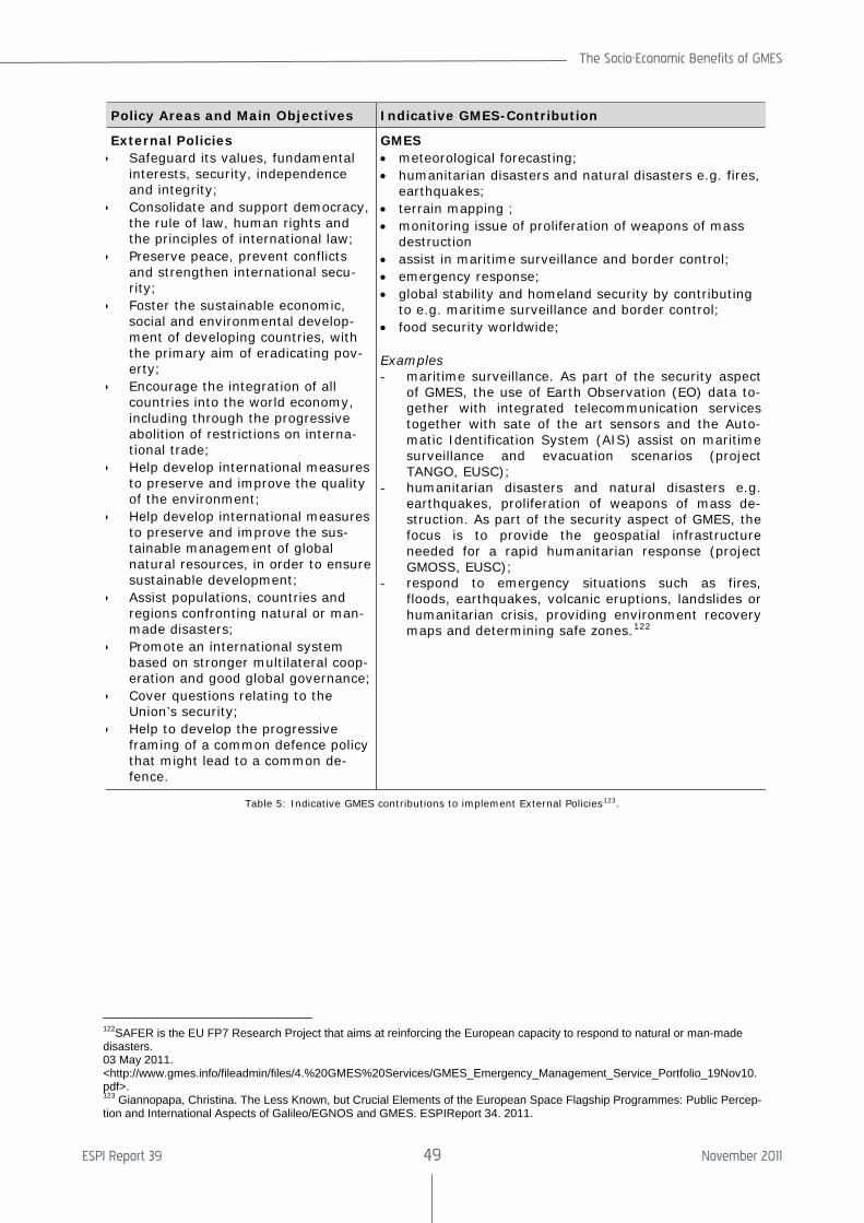
The Socio-Economic Benefits of GMES
ESPI Report 39 49 November 2011
Policy Areas and Main Objectives Indicative GMES-Contribution
External Policies • Safeguard its values, fundamental
interests, security, independence and integrity;
• Consolidate and support democracy, the rule of law, human rights and the principles of international law;
• Preserve peace, prevent conflicts and strengthen international secu-rity;
• Foster the sustainable economic, social and environmental develop-ment of developing countries, with the primary aim of eradicating pov-erty;
• Encourage the integration of all countries into the world economy, including through the progressive abolition of restrictions on interna-tional trade;
• Help develop international measures to preserve and improve the quality of the environment;
• Help develop international measures to preserve and improve the sus-tainable management of global natural resources, in order to ensure sustainable development;
• Assist populations, countries and regions confronting natural or man-made disasters;
• Promote an international system based on stronger multilateral coop-eration and good global governance;
• Cover questions relating to the Union’s security;
• Help to develop the progressive framing of a common defence policy that might lead to a common de-fence.
GMES • meteorological forecasting; • humanitarian disasters and natural disasters e.g. fires,
earthquakes; • terrain mapping ; • monitoring issue of proliferation of weapons of mass
destruction • assist in maritime surveillance and border control; • emergency response; • global stability and homeland security by contributing
to e.g. maritime surveillance and border control; • food security worldwide; Examples - maritime surveillance. As part of the security aspect
of GMES, the use of Earth Observation (EO) data to-gether with integrated telecommunication services together with sate of the art sensors and the Auto-matic Identification System (AIS) assist on maritime surveillance and evacuation scenarios (project TANGO, EUSC);
- humanitarian disasters and natural disasters e.g. earthquakes, proliferation of weapons of mass de-struction. As part of the security aspect of GMES, the focus is to provide the geospatial infrastructure needed for a rapid humanitarian response (project GMOSS, EUSC);
- respond to emergency situations such as fires, floods, earthquakes, volcanic eruptions, landslides or humanitarian crisis, providing environment recovery maps and determining safe zones.122
Table 5: Indicative GMES contributions to implement External Policies123.
122SAFER is the EU FP7 Research Project that aims at reinforcing the European capacity to respond to natural or man-made disasters. 03 May 2011. <http://www.gmes.info/fileadmin/files/4.%20GMES%20Services/GMES_Emergency_Management_Service_Portfolio_19Nov10.pdf>. 123 Giannopapa, Christina. The Less Known, but Crucial Elements of the European Space Flagship Programmes: Public Percep-tion and International Aspects of Galileo/EGNOS and GMES. ESPIReport 34. 2011.
ESPI Report 39 50 November 2011
3.3.3 Climate Change
The international dimension of environment policy has increased in importance due to a number of interconnected factors. Environ-mental problems such as climate change are global. This means that they are increasingly part of the Union’s External Policy. This fo-cuses on124:
• Promoting sustainable development worldwide and further mainstreaming environmental considerations into all EU external policies – not only our develop-ment assistance but also trade and the Common Foreign and Security Policy.
• Effective “environmental diplomacy” will mean linking environmental objectives with other international negotiations. It will be necessary to use the full potential of trade and cooperation agreements at regional or bilateral levels.
• The negotiations for Free Trade Agree-ments with partners in Asia and Latin America will be an opportunity to boost trade in sustainable goods and services.
• Promoting the Union’s environmental policies and requirements.
• Promoting the transfer of technology and/or resources with developing coun-tries as an incentive for them to address global problems such as climate change.
• Working with Member Sates in order to develop regional/country support strate-gies that adequately address environ-ment and natural resource management issues.
• Intensifying, together with Member States, the dialogue with key emerging economies such as China, India, Brazil, Ukraine and South Africa.
• Improving international environmental governance where a priority is to up-grade the United Nations Environment Programme (UNEP) by establishing a UN Environment Organisation (UNEO) with a strengthened mandate and adequate, predictable financing.
• Setting up an International Panel on the Sustainable Use of Natural Resources and supporting a global system to moni-
124 Commission of the European Communities. Communi-cation from the Commission to the European Parliament, the Council, the European Economical and Social Commit-tee and the Committee of the Regions on the Mid-term Review of the Sixth Community Environment Action Pro-gramme. COM (2007) 225 final of 30 Apr. 2007.
tor the levels of biodiversity (in particular as regards forests).
• Making sure that European environ-mental policy concerns are also taken forward in coordination with Member States in specialised organisations such as the International Maritime Organisa-tion and the International Civil Aviation Organisation.
GMES can support continuity of key meas-urements, complementing operational mete-orological measurements. GMES will also ensure availability of comprehensive global datasets (e.g. land cover change, concentra-tion of trace gases) to support improved characterisation of climate change impacts125. The level of scientific uncertainty can be re-duced by GMES information through continu-ity of critical time series and improved mod-elling. According to PricewaterhouseCoopers stakeholders indicate that they estimate a reduction in damage costs in the range of 0.1-0.5% though reduced levels of scientific uncertainty and improvement of international action to reduce climate change impact through better adaptation. Additionally GMES information will assist in optimizing the cli-mate change investment. Stakeholders also identified contributions to deforestation, es-timating a 5-20% reduction in current defor-estation levels.
The UN Convention to Combat Desertification (CCD) defines desertification as land degra-dation in arid, semi-arid and dry sub-humid areas resulting from various factors including climatic variations and human activities ac-cording to the UN Convention to Combat De-sertification (CCD). In this area, stakeholders estimated that information provided by GMES will allow better managed desertification and reduction of global costs related to desertifi-cation. The estimates range between 5-20% reduction in the rate of land degradation.
3.4 European Policy Benefits
3.4.1 Agriculture
According to DG Agriculture and Rural Devel-opment, some 21.7 million people were em-ployed in the agriculture sector across the EU-27 in 2010,. The primary sector (agricul-ture, hunting and forestry) represents 6% of employment for the EU-27 and accounted for 1.7% of GDP in 2006 ranging from 0.4% in Luxembourg to 8.8% in Romania. The Un-
125 PricewaterhouseCoopersMain Report Socio-Economic Benefits Analysis of GMES. ESA Contract Number 18868/05. 2006.
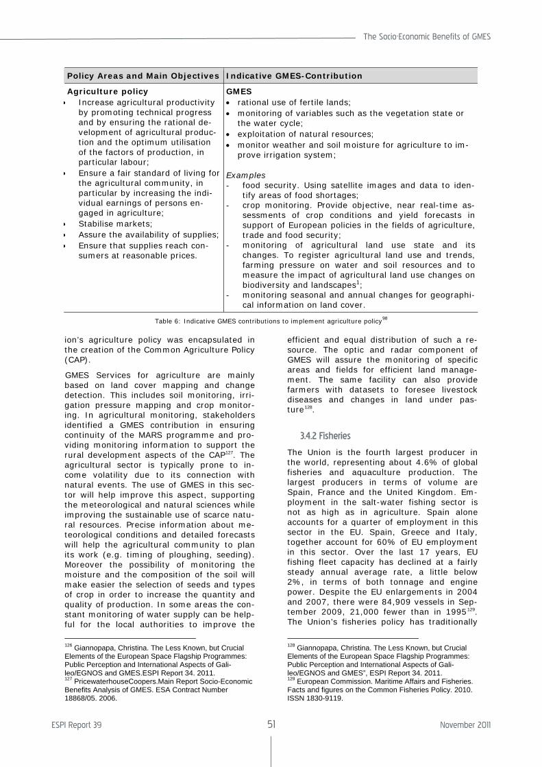
The Socio-Economic Benefits of GMES
ESPI Report 39 51 November 2011
ion’s agriculture policy was encapsulated in the creation of the Common Agriculture Policy (CAP).
GMES Services for agriculture are mainly based on land cover mapping and change detection. This includes soil monitoring, irri-gation pressure mapping and crop monitor-ing. In agricultural monitoring, stakeholders identified a GMES contribution in ensuring continuity of the MARS programme and pro-viding monitoring information to support the rural development aspects of the CAP127. The agricultural sector is typically prone to in-come volatility due to its connection with natural events. The use of GMES in this sec-tor will help improve this aspect, supporting the meteorological and natural sciences while improving the sustainable use of scarce natu-ral resources. Precise information about me-teorological conditions and detailed forecasts will help the agricultural community to plan its work (e.g. timing of ploughing, seeding). Moreover the possibility of monitoring the moisture and the composition of the soil will make easier the selection of seeds and types of crop in order to increase the quantity and quality of production. In some areas the con-stant monitoring of water supply can be help-ful for the local authorities to improve the
126 Giannopapa, Christina. The Less Known, but Crucial Elements of the European Space Flagship Programmes: Public Perception and International Aspects of Gali-leo/EGNOS and GMES.ESPI Report 34. 2011. 127 PricewaterhouseCoopers.Main Report Socio-Economic Benefits Analysis of GMES. ESA Contract Number 18868/05. 2006.
efficient and equal distribution of such a re-source. The optic and radar component of GMES will assure the monitoring of specific areas and fields for efficient land manage-ment. The same facility can also provide farmers with datasets to foresee livestock diseases and changes in land under pas-ture128.
3.4.2 Fisheries
The Union is the fourth largest producer in the world, representing about 4.6% of global fisheries and aquaculture production. The largest producers in terms of volume are Spain, France and the United Kingdom. Em-ployment in the salt-water fishing sector is not as high as in agriculture. Spain alone accounts for a quarter of employment in this sector in the EU. Spain, Greece and Italy, together account for 60% of EU employment in this sector. Over the last 17 years, EU fishing fleet capacity has declined at a fairly steady annual average rate, a little below 2%, in terms of both tonnage and engine power. Despite the EU enlargements in 2004 and 2007, there were 84,909 vessels in Sep-tember 2009, 21,000 fewer than in 1995129. The Union’s fisheries policy has traditionally
128 Giannopapa, Christina. The Less Known, but Crucial Elements of the European Space Flagship Programmes: Public Perception and International Aspects of Gali-leo/EGNOS and GMES”, ESPI Report 34. 2011. 129 European Commission. Maritime Affairs and Fisheries. Facts and figures on the Common Fisheries Policy. 2010. ISSN 1830-9119.
Policy Areas and Main Objectives Indicative GMES-Contribution
Agriculture policy • Increase agricultural productivity
by promoting technical progress and by ensuring the rational de-velopment of agricultural produc-tion and the optimum utilisation of the factors of production, in particular labour;
• Ensure a fair standard of living for the agricultural community, in particular by increasing the indi-vidual earnings of persons en-gaged in agriculture;
• Stabilise markets; • Assure the availability of supplies; • Ensure that supplies reach con-
sumers at reasonable prices.
GMES • rational use of fertile lands; • monitoring of variables such as the vegetation state or
the water cycle; • exploitation of natural resources; • monitor weather and soil moisture for agriculture to im-
prove irrigation system; Examples - food security. Using satellite images and data to iden-
tify areas of food shortages; - crop monitoring. Provide objective, near real-time as-
sessments of crop conditions and yield forecasts in support of European policies in the fields of agriculture, trade and food security;
- monitoring of agricultural land use state and its changes. To register agricultural land use and trends, farming pressure on water and soil resources and to measure the impact of agricultural land use changes on biodiversity and landscapes1;
- monitoring seasonal and annual changes for geographi-cal information on land cover.
Table 6: Indicative GMES contributions to implement agriculture policy98
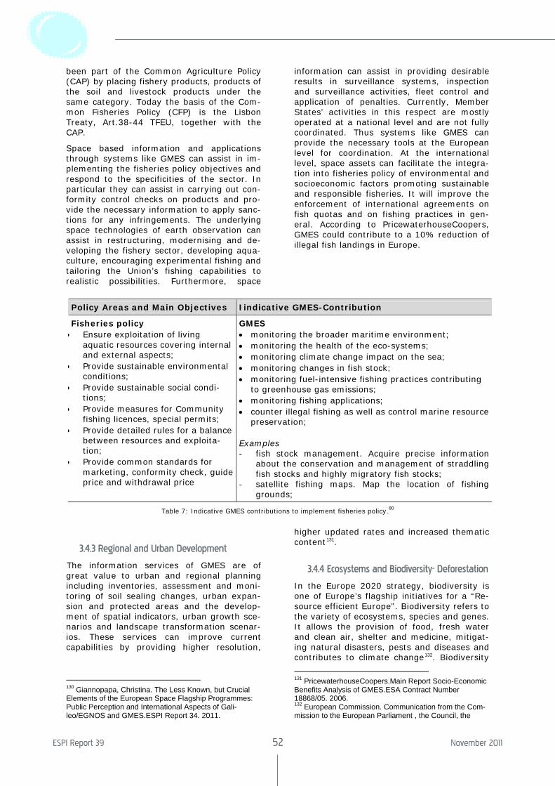
ESPI Report 39 52 November 2011
been part of the Common Agriculture Policy (CAP) by placing fishery products, products of the soil and livestock products under the same category. Today the basis of the Com-mon Fisheries Policy (CFP) is the Lisbon Treaty, Art.38-44 TFEU, together with the CAP.
Space based information and applications through systems like GMES can assist in im-plementing the fisheries policy objectives and respond to the specificities of the sector. In particular they can assist in carrying out con-formity control checks on products and pro-vide the necessary information to apply sanc-tions for any infringements. The underlying space technologies of earth observation can assist in restructuring, modernising and de-veloping the fishery sector, developing aqua-culture, encouraging experimental fishing and tailoring the Union’s fishing capabilities to realistic possibilities. Furthermore, space
information can assist in providing desirable results in surveillance systems, inspection and surveillance activities, fleet control and application of penalties. Currently, Member States’ activities in this respect are mostly operated at a national level and are not fully coordinated. Thus systems like GMES can provide the necessary tools at the European level for coordination. At the international level, space assets can facilitate the integra-tion into fisheries policy of environmental and socioeconomic factors promoting sustainable and responsible fisheries. It will improve the enforcement of international agreements on fish quotas and on fishing practices in gen-eral. According to PricewaterhouseCoopers, GMES could contribute to a 10% reduction of illegal fish landings in Europe.
Policy Areas and Main Objectives Iindicative GMES-Contribution
Fisheries policy • Ensure exploitation of living
aquatic resources covering internal and external aspects;
• Provide sustainable environmental conditions;
• Provide sustainable social condi-tions;
• Provide measures for Community fishing licences, special permits;
• Provide detailed rules for a balance between resources and exploita-tion;
• Provide common standards for marketing, conformity check, guide price and withdrawal price
GMES • monitoring the broader maritime environment; • monitoring the health of the eco-systems; • monitoring climate change impact on the sea; • monitoring changes in fish stock; • monitoring fuel-intensive fishing practices contributing
to greenhouse gas emissions; • monitoring fishing applications; • counter illegal fishing as well as control marine resource
preservation; Examples - fish stock management. Acquire precise information
about the conservation and management of straddling fish stocks and highly migratory fish stocks;
- satellite fishing maps. Map the location of fishing grounds;
Table 7: Indicative GMES contributions to implement fisheries policy.80
3.4.3 Regional and Urban Development
The information services of GMES are of great value to urban and regional planning including inventories, assessment and moni-toring of soil sealing changes, urban expan-sion and protected areas and the develop-ment of spatial indicators, urban growth sce-narios and landscape transformation scenar-ios. These services can improve current capabilities by providing higher resolution,
130 Giannopapa, Christina. The Less Known, but Crucial Elements of the European Space Flagship Programmes: Public Perception and International Aspects of Gali-leo/EGNOS and GMES.ESPI Report 34. 2011.
higher updated rates and increased thematic content131.
3.4.4 Ecosystems and Biodiversity- Deforestation
In the Europe 2020 strategy, biodiversity is one of Europe’s flagship initiatives for a “Re-source efficient Europe”. Biodiversity refers to the variety of ecosystems, species and genes. It allows the provision of food, fresh water and clean air, shelter and medicine, mitigat-ing natural disasters, pests and diseases and contributes to climate change132. Biodiversity
131 PricewaterhouseCoopers.Main Report Socio-Economic Benefits Analysis of GMES.ESA Contract Number 18868/05. 2006. 132 European Commission. Communication from the Com-mission to the European Parliament , the Council, the
The Socio-Economic Benefits of GMES
ESPI Report 39 53 November 2011
within an ecosystem enables the provision of ecosystem services, which are benefits ob-tained by the ecosystems. They are part of our natural capital, fundamental for the economy. These include direct use benefits such as harvesting (food, timber, water, fi-bre) and indirect values which are services provided by nature- these include regulating services that affect climate, floods, disease, wastes, and water quality; cultural services that provide recreational, aesthetic, and spiri-tual benefits; and supporting services such as soil formation, photosynthesis, and nutrient cycling133. Regarding forest monitoring, at the international level a global forest convention 134has been advocated for many years but progress has been slow. Thus, there is no dedicated convention addressing the protec-tion of forest systems. In 2011, the Forest Europe Ministerial Conference on the protec-tion of Forests in Europe took place in Oslo, Norway, where ministers responsible for for-ests and high level representatives from 46 countries and the European Union meet. The sustainable management of forest ecosys-tems is targeted by the Convention on Bio-logical Biodiversity135.
GMES can contribute to biodiversity and management of ecosystems by detecting and monitoring changes and pressure for change on critical habitats. It can contribute to land and marine ecosystems that are sensitive to climate changes. Examples are the Arctic and coral reefs. Monitoring habitats allows the assessment of some of the major pressures on biodiversity and improves understanding of links between habitat changes and ecosys-tems. In the area of forestry, currently changes in forest cover areas are based on statistical data collected by the National For-est Inventories. GMES could contribute in better monitoring changes in a specific area as well as globally. This allows a better as-sessment of the level of deforestation, refor-estation and afforestation. The related GMES services are:
Economic and Social Committee and the Committee of the Regions on Our Life Insurance, our Natural Capital: an EU Biodiversity Strategy to 2020. COM (2011) 244 final of 3 May 2011. Brussels. < http://ec.europa.eu/environment/nature/biodiversity/comm2006/pdf/2020/1_EN_ACT_part1_v7[1].pdf>. 133 PricewaterhouseCoopers. Main Report Socio-Economic Benefits Analysis of GMES.ESA Contract Number 18868/05. 2006. 134 Regarding forest monitoring, a global forest convention was first proposed in 1990, in the Sào Paulo Declaration of the Intergovernmental Panel on Climate Change (IPCC), At the Earth Summit in Rio de Janeiro in 1992, a binding agreement could not be reached, and the compromise was a "Non-binding authoritative statement on forest princi-ples". 135 Convention of Biological Diversity website. <http://www.biodiv.org/2010-target/default.asp>.
• Land cover mapping and land cover change mapping – this includes monitor-ing land use pressures on habitats and ecosystems and fragmentation of habi-tats
• Forest mapping – this includes monitor-ing changes in forest cover
• Arctic environment change mapping – this includes changes in snow cover, gla-cier movement and cover and changes in sea-ice cover
• Ocean monitoring – this includes moni-toring changes in physical oceanographic parameters (temperature, colour, trans-parency, salinity, sediment load) which can impact on key marine ecosystems such as coral reefs and sea grass beds.
3.4.5 Air Quality
As stated above, GMES can also bring bene-fits for air quality, facilitating and helping the implementation of different international pro-grammes and agreements and providing im-portant elements to support informed deci-sions on policy issues related to stratospheric ozone depletion, surface UV exposure, air quality and climate change.
Clean Air for Europe (CAFE), which is one of the areas to which GMES can contribute, is a programme developed to provide strategic policy advice to protect the environment and human health from the negative effects that can result from air pollution. This programme is part of the Thematic Strategy on Air Pollu-tion, created to identify gaps and priorities for future actions and to update/ revise the air pollution standards.
The Convention on Long-Range Transport of Air Pollutants is a framework under which the United Nations Economic Commission for Europe signed several agreements to control the transport of pollutants through the at-mosphere.
The Vienna Convention for the Protection of the Ozone Layer/ Montreal Protocol on Sub-stances that Deplete the Ozone Layer stipu-lated that the production and consumption of compounds that deplete ozone in the strato-sphere-chlorofluorocarbons (CFC’s) halons, carbon tetrachloride, and methyl chloro-form—were to be phased out by 2000 (2005 for methyl chloroform). GMES services could offer better monitoring of these specific pol-lutants.
Another Protocol to which GMES can bring significant contributions is the Gothenburg Protocol. Under this Protocol emission ceilings for 2010 were established for four pollutants:
ESPI Report 39 54 November 2011
sulphur, NOx, VOCs and ammonia. It also established tight limit values for specific emission sources (e.g. combustion plant, electricity production, dry cleaning, cars and lorries), requiring best available techniques to be used to keep emissions down.
Taking into consideration the current frame-work in this area, an assessment of GMES benefits for air quality was prepared. In the medium to longer-term, GMES can play a role in advancing modelling capabilities through combining environmental and health related inputs and consequently, promoting addi-tional health and welfare gains amongst citi-zens through improved modelling, public policy and ultimately, behaviour. But even these benefits will not be felt uniformly by all Member States, depending on the level of the modelling capabilities in measuring air quality achieved by each of the States. This led to a higher benefit prediction to the Central and Eastern Europe. However, the short term impact on monitoring air quality was consid-ered small, due to the numerous existing data captors, information providers and re-lated services.
Besides the air quality benefits to which GMES can clearly contribute, two more bene-fits were raised by stakeholders: the first concerns the relationship between GMES, air quality forecasting and potentially reduced damage to buildings, while the second relates to potential changes in agricultural yields.
3.4.6 Land Use Planning and Water Quality
In the water quality context, the most sub-stantial piece of water legislation from the European Commission is the EU Water Framework Directive (WFD), which requires all inland and coastal water bodies to reach at least “good status” by 2015. The WFD sets a framework that should provide substantial benefits for the long term sustainable man-agement of water, complementing the Ni-trates Directive and other industrial pollution directives (for example, the Urban Waste Water Directive).
GMES through land cover, land use and land use change mapping, including forest and urban cover mapping and change detection, can provide detailed spatial information that will enable authorities to comply with the requirements of the WFD, principally through its Water Quality services.
Adopting a cautious approach, the GMES benefits for water quality were not assessed or quantified, due to the limitation that the objectives of the WFD can result in. However it was taken for granted that GMES could deliver benefits in this area, even if express-
ing it in quantitative terms is not the best approach.
3.4.7 The Marine and Coastal Environment
The policy context for the marine and coastal environment has to be seen from different perspectives: international agreements and the regional agreements.
There are two main international agreements. The first is the MARPOL (Marine Pollution) 73/78 Convention on the Prevention of Pollu-tion from Ships, which requires cooperation among parties to detect operational and de-liberate pollution from ships. The second agreement, the OPRC 90 Convention on Oil Pollution Preparedness, Response and Co-operation established the cooperation of all parties to prepare for and respond to oil pol-lution incidents.
Four regional agreements are of great impor-tance. Firstly, the OSPAR 92 Convention for the Protection of the Marine Environment of the North-East Atlantic contains a general obligation to collaborate in regular monitoring and assessment of the state of the marine environment. GMES could improve the effec-tiveness of its strategies with respect to haz-ardous substances. Secondly, the Bonn Agreement 83 on Co-operation in Dealing with Pollution of the North Sea by Oil and Other Harmful Substances requires parties to, for example, inform each other of harmful substances that are likely to constitute a se-rious threat to the coast or related interests (Early Warning Reporting System).
The remaining two agreements are the main conventions for European seas. The Barce-lona Convention, or the ‘Convention on the Protection of the Mediterranean Sea Against Pollution’ of 1976 (amended in 1995) and the Protocols drawn up in line with this Conven-tion aim to reduce pollution in the Mediterra-nean Sea and protect and improve the ma-rine environment in the area, thereby con-tributing to its sustainable development. The Helsinki Convention or the ‘Convention on the Protection of the Marine Environment of the Baltic Sea Area’ was signed in 1992 by all the States bordering on the Baltic Sea, and the European Community.
In the European policy context, there are several legal frameworks to which GMES can also contribute. These include, for example, the Ship Source Pollution Directive (EC 2005e) and the increased role in pollution surveillance of the European Maritime Safety Agency, the EU’s Sixth Environment Action Plan (EC 2001a) and the EU Framework Di-rective in the field of water policy.
The Socio-Economic Benefits of GMES
ESPI Report 39 55 November 2011
In the field of polar environmental informa-tion services, where the International Mari-time Organisation (IMO) Code for Polar Navi-gation framework established measures for the safe navigation of ships and the preven-tion of pollution in polar waters, GMES can contribute by providing services that will im-prove ice maps, which will increase maritime effectiveness. With this mapping service, GMES will contribute to shortened shipping routes and hence reduced air pollutant emis-sions, contributing to the EU Strategy to re-duce atmospheric emissions from seagoing ships, particularly emissions of SO2, NOx and CO2.
3.4.8 Risk and Civil Protection
At the European Union level, the purpose of cooperation in the field of risk and civil pro-tection is to help ensure better protection for people, the environment and property in the event of natural and technological disasters. This cooperation is important because many EU Member States frequently suffer earth-quakes, floods, landslides, storms, forest fires and technological disasters. If the primary responsibility for dealing with events of this type is primarily at national level, there is an important body of work emerging at EU level which concentrates on transfer of best prac-tices and sharing of key assets and re-sources.
The European Union has the following objec-tives in the field of Risk and Civil Protection:
• to support and supplement efforts at na-tional, regional and local level with re-gard to disaster prevention, the prepar-edness of those responsible for civil pro-tection and intervention in the event of disaster;
• to provide better public information to enable increased levels of self-protection for European citizens;
• to establish a framework for effective and rapid cooperation between national civil protection services when mutual as-sistance is needed; and
• to enhance the coherence of actions un-dertaken at international level in the field of civil protection especially in the con-text of cooperation with the new and candidate Central and Eastern European countries in view of enlargement and with the partners in the Mediterranean region.
In order to achieve these objectives many activities have been undertaken. As exam-ples: the establishment of several operational instruments by the Commission in collabora-
tion with the Civil Protection Authorities of Member States to ensure better preparedness in the case of requests for mutual assistance; the enhancement of the response capability of all those directly involved with Civil Protec-tion operations; the organization of work-shops and exchange programmes for ex-perts; and the adoption of 112, as the single European emergency call number for the Union.
There are several legal instruments for civil protection: the Community Civil Protection Mechanism, established in October 2001 (EC 2001b), is an operational instrument de-signed to enhance preparedness and to mobi-lise immediate civil protection assistance in the event of disasters; the Civil Protection Action Programme and the adopted proposal for a Council Regulation Establishing a Rapid Response and Preparedness Instrument for Major Emergencies; and, for the purpose of responding to major disasters, the Interna-tional Charter “Space and Major Disasters” was signed, creating one mechanism based on international cooperation on space as-sets136.
For these programmes on risk management and civil protection to work, accurate, reliable and timely information is required. GMES services will provide an important input to help meet this requirement.
GMES will also be able to provide different kinds of information for the different informa-tion services.
Land information services:
• Land cover/ land use assessments. Appli-cations include fire risk and damage as-sessment, forests;
• mapping at all scales, and agricultural impact assessment;
• Land cover/ use information for water quality / contamination monitoring and run-off modelling;
• Impervious areas / soil sealing levels (as an input to flood hydrograph determina-tion);
• Irrigation / agricultural water consump-tion; and
• High resolution spatial planning services.
Flood and fire risk information services:
• Pre-event – risk assessments based on land cover. For fires this includes fuel availability, paths for the fire to spread
136 For more detailed information about the International Charter “Space and Major disasters” see point 2.3.1. of this study.
ESPI Report 39 56 November 2011
and areas that could be affected. For flooding, land cover changes such as soil sealing and vegetation characteristics af-fect the rate of flood wave propagation.
• During-event – GMES offers services that allow the scale and coverage of the event to be assessed in support of rescue ac-tivities
• After-event – GMES services provide support to damage assessment and also assist in the process of learning from the event to ensure that it is not repeated.
• Reduce social and economic impacts from forest fires.
Geohazards – Seismic, Landslide and Subsi-dence:
• Landslide monitoring, inventory and sus-ceptibility: reduced impact of localised land movement (landslides and urban subsidence);
• Subsidence monitoring and causality at-tribution
• Ground movement maps for use in as-sessments of seismic processes.
• Reduce the social and economic impact of major seismic events (earthquakes and volcanoes);
• Reduce damage and business interrup-tion (better warning, fewer false alarms)
The final benefit assessment took into con-sideration the different events: floods, fires, geohazards – seismic, landslide and subsi-dence.
The stakeholders consulted for the GMES benefit assessment on flooding estimated
that GMES could reduce damage by around 1.5%, and noted that in the context of ex-treme events, inputs to planning and risk management, this assumption could be re-garded as conservative.
GMES input for fires was centred on the abil-ity to contribute actively to the management of events that are still in progress. Stake-holders considered that GMES could deliver a 1% reduction in mortality, morbidity and property damage, with predominance in Southern Europe, which has the highest prevalence of wildfires. These improvements are based primarily on improvements in fire-fighting operations enabled by rapid and regular situation updates that GMES provides alongside other vital information.
The basis for GMES contributions to geohaz-ards- industrial risk is centred on the analysis of ground movement detection and monitor-ing. Stakeholders underlined that GMES benefits would definitely arise but they were difficult to express in quantitative terms. The consensus was that the majority of industrial accidents result from problems within the plants themselves rather than from external environmental stimuli. In this field, GMES was considered to deliver potentially benefi-cial applications in some areas, such as pipe-line monitoring.
In Geohazards - Public infrastructure stability monitoring, stakeholders were not able to quantitatively express the role to be played by GMES in promoting public infrastructure security and ultimately the reduction in costs associated with subsidence that could result. However, they registered a commitment to the concept that GMES could deliver benefits in this area.
The Socio-Economic Benefits of GMES
ESPI Report 39 57 November 2011
3.5 Benefits per Area
Topic and Study Benefits
Forest Monitoring
Study: GSE-FM
GSE-FM (GSE- Forest Monitoring) focused at providing forest monitoring and operational services and products for climate change, forestry and environ-ment. Forest monitoring for climate change -Forest monitoring Inputs for National Greenhouse Gas (GHG) Reporting service Direct benefits:
• cost savings compared to alternative methods; • higher reliable estimates (reduce uncertainty), • geo-referenced information; • compliance with international and national monitoring obligations
(avoid penalties). Indirect benefits:
• more homogenous and consistent information at a global level, lead-ing to improved decision making (positive effects on environment).
Forest monitoring for climate change -Forest monitoring inputs for CDM pro-jects service Direct benefits:
• cost savings compared to alternative methods; Indirect benefits:
• multi-use of data (e.g. forest management); • future projects: contributions for employment growth.
Forest monitoring for sustainable forest management - mapping and moni-toring of disturbances service Direct benefits:
• cost savings resulting from coordination, integration and field work; • homogenized data, more detailed and consistent to reduce uncer-
tainty; • time gains in the collection of data.
Indirect benefits: • more efficient and reliable regeneration of forest leading to higher
production; • improved operational planning in forest fire fighting; goodwill for the
user organisation; • improved conservation and use of resources: soils and water re-
sources; • preservation of ecosystem functions-nutrient cycling; recreational
benefits for citizens. Forest monitoring for sustainable forest management - Sub-national forest information update service Direct benefits:
• Costs savings compared to alternative methods; • more frequent data updates; • repetition cycle can be enhanced from 10-15 years to 3-5 years; • more homogeneous and accurate data can be provided.
Indirect benefits: • Goodwill: improved trust of society;
Forest monitoring for environmental Issues & nature protection - Land cover and forest indicator service Direct benefits:
• Improved quality of data for environmental modelling and monitor-ing;
• Compliance with international and national monitoring obligations (avoid penalties);
ESPI Report 39 58 November 2011
Topic and Study Benefits
Indirect benefits: • Improved decision making on environmental issues (reduction of air
pollution, improved landscape planning, improved nature protec-tion);
• Recreational benefits for citizens;
Food Security Moni-toring Study: GMFS
GMFS (Global Monitoring for Food and Security) focused at establishing op-erational services for food security. Direct benefits
• Improve agricultural productivity and enhance livelihoods and food security in poor rural communities, long term development of agri-cultural practices;
• Develop and conserve natural resources, identification and monitor-ing of environmental problems;
• Expand rural infrastructure market access and contribution to infra-structure analysis and development;
• Efficiency gains – providing the same level of output for less effort. Indirect benefits
• Ensure access to food for the most needy and reductions in food in-security from better informed decision making;
• More sustainable development of agricultural practices. • Providing early warning or development services to benefit from new
techniques for analysis and forecasting; • Expanding overall capability to provide information to downstream
users; • Improving accuracy via better methods or by cross checking existing
ones; • Improving the coverage and timeliness of output; • Strengthen capacity for knowledge generation and dissemination; • Additional resources for sub-Saharan Africa and assist agricultural
development programmes; • Access to improved information on global and regional environ-
mental issues related to food security; • more efficient use of food aid resources, from taxation through to
better informed decision making; • Benefits from the development of a substantial and independent
European monitoring capability for food security (e.g. more competi-tive service industries, more advanced and focused space pro-gramme);
Social benefits • Mortality reductions; • Health improvements; • Consequent improvements in economic productivity.
Strategic benefits • Developing a more independent European monitoring capability and
infrastructure • Benefits which are shared with a range of other applications (though
care is needed not to double count benefits across different sectors); • Increase European influence, but taking a greater share of the
supply of food security to US providers, there may be benefits in the longer term for European economies.
Costal Monitoring Study: CoastWatch
CoastWatch focused at integrated geo-information service for costal zone management. Water quality monitoring service Direct benefits:
• Operational cost reduction for users (reduction of cruises expenses for national surveys and help optimizing the cruises planning);
The Socio-Economic Benefits of GMES
ESPI Report 39 59 November 2011
Topic and Study Benefits
• Improvement of surveys and watching activities; Indirect benefits:
• Sea quality improvement (better management of sea resource and make an impact on the recovery of all aspects of Sea quality);
• Better managing of marine resources; • Better pollution monitoring; • Better stock assessment; • Algal bloom mitigation; • Benefits for economic activity (fisheries/tourism); • Preserve attractiveness of coastal zone for tourism; • Capability preservation and capability improvement for fisheries and
aquaculture; Societal benefits
• Fauna conservation; • Health preservation (regarding harmful algal bloom prevention); • General knowledge on coastal zone phenomenon; • Long term changes follow up, understating of evolutions;
Coastal Land mapping service Direct benefits:
• Operational costs reduction for users; • Improve current environmental indicators and follow-up based on
Land Cover Maps/ Land Use changes; Indirect benefits:
• Better land planning / land management (urbanization, control, tour-ism, pressure limitation, controlled coastal equipment;
• Improved habitat value preservation; • Reduced impact of catastrophic events and easier damages assess-
ment (flooding in estuaries, areas, storms, tsunamis, coastal ero-sion);
• Positive impact on economic activity Societal benefits;
• Reduced environment degradation; • Long term changes follow-up, understanding of evolutions;
Costal Environmental Indicators Service137 Direct benefits:
• Reduce costs of data collection and processing (easier acquisition, treatment and harmonization of the data);
• Better decision making regarding all the fields of relevance of CW in-dicator services;
Indirect benefits: • More efficient risk management preventive measures (impact on
economic activities, environment, social aspects); • Better integrated management of coastal resources regarding
coastal zone uses (fisheries/ tourism/agriculture); • Strategic planning (conflicts and trade offs); • Reduced impact and damages of coastal processes (wind, tides,
waves with high or exceptional levels, etc); • Improved nature conservation (natural habitat, biodiversity, wild
fauna and flora); • Economic potential preservation; • Integrated information;
Societal benefits:
137 As support to the implementation, control and improvement of decision-making, there is a strong demand for environmental indicators from the local to the European scale. The EEA monitors numerous indicators that give a consistent and complete overview of environmental topics and that support both decision making on, and the implementation of, environmental policies. In the middle and longer term, the indicators constitute a basis for assessing the impact of an environmental program and can drive new actions and policies.
ESPI Report 39 60 November 2011
Topic and Study Benefits
• Improved common knowledge on coastal systems; • Human health and welfare improvement; • People goods and property preservation; • Better individual and collective awareness and sensitiveness regard-
ing coastal zones issues and stakes; Hydrodynamic service Direct benefits:
• Better knowledge of wave conditions along coastal zones for eco-nomic actors;
• Improve other CoastWatch services with a dynamic approach; Indirect benefits:
• Benefits for the coastal zone value/productivity; • Better dimensioning, positioning and impact assessment of sea de-
fences; • Port operations benefits; • Flood awareness by forecasting overtopping of sea defences; • Better mitigation of pollutions and contaminations (oil spills); • Societal benefits: • Security improvement impacting;
Sea Ice Monitoring Study: ICEMON
ICEMON focused on rear real time ice products and off-line products on sea ice monitoring for marine operation safety, climate research, environmental management and resource exploitation in Polar regions. Ice navigation and sea transportation (Segment A)
• cost savings in terms of time and fuel saved, due to the use of im-proved Ice services (NRT high resolution) and ice forecasts services;
• the improvement of ice services would: reduce the risk of accidents, which is of utmost importance when oil-tankers are at stake because an accident in this case can mean high social costs due to environ-mental damage caused by oil spill;
• improve daily operations of border patrolling and checking fishing territories by coastguards.
Off-shore and ship design (Segment B) • direct beneficiaries: engineering companies, classification compa-
nies, insurance companies and Oil/gas companies are the. • Using Ice information they would be able to save time searching for
ice statistics for the assessment and development of optimal designs for off-shore constructions and ships,
• provide specifications for meteorological/ice conditions; • improve the assessment of risks associated with off-shore opera-
tions; • improve predictions of compensation payouts.
Ports and maritime authorities (Segment C) • efficiency gains through the improvement of logistics planning and
optimization of the loading and unloading process. Meteorological market (Segment D)
• provide weather services. Environmental monitoring (Segment E)
• costs savings; • efficiency gains;
Climate modelling and research (Segment F) • benefits would come from the off-line products;
Ocean Monitoring
ROSES
ROSES (Real-time Ocean Services for Environment and Security) focued on operational oceanography.
• Efficiency and additional benefits for organisations that currently monitor oil spills and HABs using aircraft and in-situ methods.
The Socio-Economic Benefits of GMES
ESPI Report 39 61 November 2011
Topic and Study Benefits
ROSES services will allow them to use their aircraft more effectively and extend their area of coverage. By augmenting the coverage in this way using ‘unseen’ satellites, there will be a considerably en-hanced deterrent effect.
• Benefits for national Ministries by allowing them to come closer to the goal of fully meeting their reporting obligations in open oceans.
• Benefits for European Policy makers from access to more compre-hensive and consistent information on the global environment
• Benefits for citizens from information on specific regions and issues leading to more effective decision-making and consequent environ-mental improvements over time.
• Benefits for operators in a range of industries for whom knowledge and forecasts of pollution and algal blooms is critical, such as fisher-ies, aquaculture and coastal tourism.
• Benefits for European service and space industries in terms of global competitive positioning if they can provide continuity of existing mis-sions in a flexible and cost effective manner.
Atmosphere Moni-toring PROMOTE
Benefits for the Ozone service: • ensure long-term consistent global total ozone data sets; • provide input to Weather Forecast models; • improve accuracy of 5-10 days weather forecasts; • provide input to chemical transport model used for meteorological
analysis; • Allows UV forecasting by ozone forecasting;
Benefits for the UV parameters services: • ensure long time series of surface UV exposure and radiation inten-
sity [measurements]; • complements ground measurements; • improves accuracy and standardisation of UV forecasting;
Benefits for air quality monitoring and forecasting service: • Complement ground measurement by adding information on “in be-
tween situations” or in geographic areas where ground stations are lacking or scarce;
• Provides homogenous quality across state boundaries; • Provides the global picture and air pollution trends on that scale; • Satellite data serves the purpose of validating and improving mod-
els; • Improves accuracy and standardisation of air quality forecasting; • Facilitates widespread use of air qualify forecasting services by pro-
viding a pan European air quality service; • Allows easy implementation of street-scale air pollution forecasts in
cities;
Humanitarian Aid RESPOND
RESPOND focused on supporting European and international relief by provid-ing proactive and reactive services of geographic information (eg. basic mapping, crisis and damage mapping, situation maps, refugee/IDP support maps) General
• facilitate committed organisations by providing them with means to improve decision making and increasing operational efficiency;
• proactive and reactive services to be implemented: basic mapping service, crisis and damage mapping service, situation maps, refugee support map service, thematic (reconstruction, planning, etc) map-ping, alert services, communication/ reporting resource service and in field mapping and training services;
• solutions to the problems of using mapping for humanitarian aid by providing services that add value;
• provide easy access to high quality objective information, pooled ca-
ESPI Report 39 62 November 2011
Topic and Study Benefits
pabilities, continuity of the services and affordable satellite images or maps;
• concrete benefits were identified to three different orders of beneficiaries:
“First order” beneficiaries138 - Aid agencies: • improvement in the overall impact of funding through faster infor-
mation availability which would led to faster reaction times; • improve decision making on priorities for resource allocation and
cost savings through sharing common resources; • sharing common resources among aid agencies leads to the avoid-
ance of duplication, sharing of costs and hence overall cost reduc-tion;
• awareness raising, public relations, additional tool for raising funds; “Second order” beneficiaries139 – Humanitarian Aid operations:
• Efficiency gains – improved means for logistics planning; • lives saved; • reduced damage to land and livestock; • avoid evacuation of aid workers in the field since Respond map high-
lights the exact location of the operations and shows concerned poli-ticians that aid workers are not in a dangerous or prohibited zone;
• availability of global public good; “Third order” beneficiaries140 - Humanitarian situation:
• Cost avoidance by saving human lives and reducing damage to properties, infrastructure, livestock;
• Efficiency gains by receiving appropriate and timely aid and faster economic recovery (growth, national income, imports, exports, pub-lic finances, employment, etc);
• Reduced human suffering; • Improved quality of life (sanitation, housing, educations, livelihood,
nutrition); • Reduce spread of disease; • Environmental impacts;
138 Considered as Donor entities, they constitute some of the primary users of Respond products and services. These include services of the UN and EC, NGOs and national donor governments. 139 Humanitarian aid operations taking place in the region of the crisis (e.g. emergency unit in the case of natural disasters): departments of the UN (e.g. UN DPKO) and NGOs. 140 End beneficiaries. For example: the quality of life for refugees living in refugee camps depends on the efficient management of such camps.
The Socio-Economic Benefits of GMES
ESPI Report 39 63 November 2011
Topic and Study Benefits
Urban Monitoring GUS (Urban Atlas)
GUS (GMES Urban Services) or Urban Atlas focused on geo-spatial informa-tion for urban planning and monitoring the urban environment. Benefits for City administrations
• free access to urban atlas, which will permit the allocation of that money for other purposes;
• benefit from high quality basic reference data set; • accessing better information concerning key urban issues (land
change, for example) will allow the city administration to undertake city planning tasks more efficiently and improve quality of decisions;
• reduce the risk of taking wrong decisions; • efficiency gains; • cost avoidance will be benefits coming from GUS; • identification of green areas including private gardens as preparation
for the city’s Green plan; • improved monitoring of Master plans; support to decision makers
concerning updates of master plan; Benefits for EU Institutions - DG REGIO
• efficiency gains; • improved impact assessment; • benefit from improved means for assessing the potential impact of
EC Structural Funds resulting in an optimization of socio-economic benefits;
• better staff coordination of the various projects;
Aqua-Soil Monitor-
ing
AquaSoilSAGE
AquaSoilSAGE (Aqua-Soil Geo-Information on Environmental Pressure and State) focused on the provision of advanced geo-inromraiton on environ-mental pressure and state, providing services for water quality and water shortage and EO derived ‘artificial surfaces’ and their combined analysis with ancillary data SAGE on a European level Direct benefits
• Potential savings through the reduction of time needed for the identi-fication and retrieval of suitable data.
• Reduction of time required to harmonise data. Indirect benefits
• Improved environmental information for integrated policy measures; • Better information: spatial detail, synoptic data, reliability and accu-
racy, frequency of update; • information which is more accurate and timely than present data
sources; • ensure more coherence between different levels of decision making:
local/regional/national/international; AquaSAGE for water abstraction by irrigation (Mediterranean) Direct benefits
• Improve identification of causes of water bodies at risk and enable the development of a better management plan to reduce these causes and a better monitoring network to check the effects of the management plan.
• Improve management of crisis situations (if the information on irri-gated surfaces can be provided early in the irrigation season);
• Reduce the costs of the monitoring network to be implemented: fo-cus on hot spots (critical areas);
Indirect benefits • better management of water resources achieved by catchment au-
thorities will assist easier operational management and supply of a better-balanced resource;
• lower costs due to less difficult situations to manage; • improve water operational management (basically the decision to re-
ESPI Report 39 64 November 2011
Topic and Study Benefits
lease water from reservoirs) by better prediction of irrigation needs; • better decisions on irrigation regulations; • more optimal amount of water in the rivers;
AquaSAGE for boreal forests (Sweden) Direct benefits
• Accurate information to the user on water quality will indicate where in a drainage basin problems occur or may arise;
• Wall-to wall datasets based on EO of forest indicators • Improved source apportionment modelling for nitrogen based on
FYRIS model; • Cross-border analysis providing homogeneous datasets; • Potential reduction of costs for mitigation due to early warning of
polluted waters; • Cost savings due to harmonised data collection and more efficient
management across borders; • Form a basis for the early stages of the WFD implementation;
Indirect benefits • water quality assessment for surface waters in the drainage basin
which can be used as a common basis for several stakeholders; • Research institutes will have a broad use of intermediate and final
products for different research purposes, research related to service will provide feedback to the future service development;
• contribute to the objectives of the WFD by providing a basis for the sustainable use of the water environment;
AquaSAGE for agri-environmental geo-information (Germany) Direct benefits
• Organisations obliged to report on WFD issues will benefit from Aq-uaSAGE as it responds directly to user needs;
• lncreasing accuracy in modelling diffuse emission processes; • change the character of the risk assessment procedure towards a
more commercial package including additional costs for data and services which do not arise in the project-based approach;
• coordinated and harmonized data collections; • cost savings at national and local levels for those users having to
collect the data; • more efficient management (e.g. data sharing, pooling of resources,
harmonized environmental reporting) across the borders; • better understanding and the early detection of potential risks and
sources of environmental degradation; Indirect benefits
• improved stakeholder participation through dialogue, transparent processes, and account ability;
• increased international co-operation especially in the field of envi-ronment;
• better public access to information • cohesion through new international and regional co-operation
agreements • More efficient use of public sector environmental regulatory budgets • Increased institutional funding for long-term monitoring will benefit
the private and public sector alike; SoilSAGE Direct benefits National level:
• Increase of efficiency and objectivity as a result of semi-automated processing of data;
• reduction of collection effort and production time; • better monitoring of soil sealing issues on national level;
Regional level: • Savings in expenditure on the interpretation of aerial photography; • increase of efficiency and objectivity; • higher quality alternative information;
The Socio-Economic Benefits of GMES
ESPI Report 39 65 November 2011
Topic and Study Benefits
Indirect benefits • Improved information permits policy or decision makers at a Euro-
pean, national and regional/local level to base their policies or deci-sions on the SoilSAGE data;
• revised and improved target planning (spatial planning etc.) and im-proved comparability of data on European, regional and local levels;
Land Hazard Moni-toring TerraFirma
TerraFirma focused on a pan-European ground motion hazard information service related to the monitoring of landslides, seismicity and subsidence. Economic Benefits a) Reduced infrastructure, survey and monitoring costs Due to better knowledge of risk areas and understanding of the phenomenon (off-the-shelf information from archives dating from more than 10 years), the following cost saving are expected:
• reduced survey, monitoring and study costs for major urban infra-structures,
• better urban planning which is expected to reduce overall infrastruc-ture planning and construction costs in risk prone areas.
b) Reduced costs due to avoided catastrophic events and structural damage Such benefits are expected since Terrafirma information will be available in high-density urban areas, with the possibility of focusing on risk areas for planning / remediation purposes. For the four main type of risks considered (subsidence, landslides, earth-quakes, swelling and shrinking), the following cost savings are expected:
• Property damage and cleaning and rebuilding costs (including reloca-tion);
• Associated lost economic production from activities located in dam-aged areas;
Other benefits • Improved differentiation, knowledge and understanding of risk areas
resulting in accessible information on a consistent format; • Benefits due to better public awareness on geological surveys, in
particular in urban areas; • Negative benefits (or “dis-benefits”) which could arise from misun-
derstandings of risks, potential increases of insurance costs or in-formation overloads: it is assumed that these aspects could be over-come with proper communication and promotion campaigns.
Non-quantifiable benefits due to other possible applications of the proposed products: Financial Benefits
• Product sales: data processing services for Basic and Cas-ual/modelled products,
• studies, additional monitoring services • Reduced study costs if any; • Reduced costs on legal settlements of disputes over damages; • Reduced insurance costs;
Arctic Monitoring
The Northern View
The Northern View focused on the development of operational services to serve public sector users requiring information to develop, enact and enforce environmental policy in sensitive Northern environments. Iceberg detection service:
• Commercial shipping on the North Atlantic great circle route benefits from shorter routes and direct economic savings;
• Reduced pollution due to the shorter routes • Improved safety;
Glacier monitoring service: • Better management of glacial assets increases electricity yields • Reduced pollution as a greater proportion of power comes from hy-
droelectric sources. • Improved safety (from risks of flooding)
ESPI Report 39 66 November 2011
Topic and Study Benefits
• Long term sustainability of hydro power schemes; Oil Spill Detection service:
• Environment Canada achieves deterrent effect to reduce pollution; • Reduced oiling of sea birds; • Reduction in other environmental damage due to oil spills;
Sea-ice monitoring service: • Inuit land economy benefits from better information to make hunting
and fishing more viable. • Safer transport on the ice saves lives; • Northern communities are sustained in situ. • The economic and social costs and negative impacts of other strate-
gies (such as relocation) are avoided; Land cover mapping service:
• Regional and national environment agencies achieve more effective development and monitoring of policies that govern human activities in sensitive polar ecosystems;
• Better understanding of the human impact on sensitive northern en-vironments;
Lake ice monitoring service: • Local communities benefit from a more reliable, safer and cheaper
transport system. • Environmental damage due to traffic on unsuitable surfaces is re-
duced River Ice Monitoring service:
• Local residents, businesses and insurance companies benefit from reduced loss of property and life due to better flood warnings
• Scientists gain better long term understanding of the impacts of climate change on drainage basins
Natural Hazard Monitoring –floods and fires RISK-EOS
RISK-EOS focused on services providing a European serving capability for organisations and institutions in managements of natural hazards. Avoided costs of damages
• Reduced casualties and injuries (as well as consequences for public health);
• Reduced economic damages (property damage and economic activi-ties) as well as environmental damages (especially as concerns for-est fires);
Other cost savings: • Reduced prevention costs (prevention plan elaboration, flood protec-
tion investments and O&M, forest maintenance); • Reduced anticipation costs (flood forecasting services, fire alert sys-
tems); • Reduced crisis management costs (rescue activities, fire fighting, re-
covery). Flood Protection:
• RISK-EOS will impact on flood protection investments in two ways: providing refined risk assessment (“Flood Risk Assessment” Service) and the updated localisation of assets (“Assets Mapping” Service);
• RISK-EOS will generalise the availability of flood extent data (Flood Risk Analysis service) for European river basins;
• capacity to model flood events will be useful to support the decision making process and estimate the interest and efficiency of a given protection system;
• RISK-EOS may provide essential inputs for the elaboration and up-dating of flood risk prevention plans;
Flood Management: • For flood management, RISK-EOS services aim at the delivery of in-
formation on assets mapping and flood risk mapping; • RISK-EOS will improve the management of crisis operations thanks
The Socio-Economic Benefits of GMES
ESPI Report 39 67 November 2011
Topic and Study Benefits
to its flood rapid mapping service; • decision-making and the prioritisation of actions will benefit from co-
herent and up-to-date data sources (Assets mapping service); Forest Fires:
• Provide in-time information to mobilise fighting means and to ensure the better coordination on the ground for forest fires;
• RISK-EOS (RFM and RM) will provide high frequency geo-located in-formation on forest fires that will ease the coordination of fighting means and contribute to feed-back by authorities;
• RISK-EOS’s fire mapping service and burnt scars monitoring service will provide information on forest fires’ consequences - an input for recovery activities and damages’ assessment;
• RISK-EOS will provide rapid mapping of the burnt area in order to support the organization and the planning of recovery actions;
• increase overall understanding of resulting environmental damages and knowledge of natural recovery mechanisms and environmental damages;
Socioeconomic Benefits Analysis of GMES, PwC
Strategic & Political benefits: • GMES responds to a perceived gap in the extent to which we feel in-
formed on key environmental issues; • GMES can support improvement in the perceived reliability of gov-
ernment environment information sources; • GMES adds value by joining previously heterogeneous data streams
into an integrated, consistent overview to support more effective in-teraction between different government agencies;
• GMES can provide reliable characterisation of natural and technologi-cal hazards, comprehensive action against trans-national organized crime, effective management of Europe’s borders and promote de-mocracy, stability and economic development in our immediate sphere of influence, in order to maintain Europe as an area of free-dom, security and justice;
• Reliable monitoring, intelligence and analysis information to ensure that these policies can be implemented in the most appropriate manner;
Benefits to EU External policies:
• Climate change: • GMES can support continuity of key measurements, complementing
operational meteorological measurements; • GMES will ensure availability of comprehensive global datasets (e.g.
land cover change, concentration of trace gases) to support im-proved characterisation of climate change impacts;
• GMES information will reduce the level of scientific uncertainty with respect to the extent and impacts of climate change on critical eco-systems and vulnerable geographic areas;
• GMES by reducing the level of scientific uncertainty will consequently improve international action to reduce climate change impact through better adaptation;
• GMES can have an impact in optimising climate change adaptation investment;
• GMES can potentially generate additional benefits related to climate change policy through support to international efforts in reducing tropical deforestation;
Desertification: • GMES can contribute to the analysis of land cover and land cover
change to support monitoring and assessment tasks; • identification of areas at risk from degradation and determining the
current extent of degradation; • GMES can map vegetation and agro-ecological zones, change detec-
ESPI Report 39 68 November 2011
Topic and Study Benefits
tion in vegetation and agro-ecological zones, identification of risk changes and assessment of bushfires, crop yields and water sup-plies;
• support to mapping of socioeconomic factors such as population movement, cultivation, deforestation and overgrazing;
Development, Aid and Common Foreign & Security Policy: • GMES improved mapping could enable access to crisis areas and fa-
cilitate the more effective use of existing infrastructure; • lead to more rapid response times, reduced delivery costs and more
robust aid delivery logistics; • improved mapping could also assist in the management of popula-
tion pressures; • GMES could provide more accurate estimates of crop failures in local
regions; • potentially identify geographical areas of humanitarian need in the
context of natural disasters; • potential impact of GMES is estimated to be a reduction in mortality
and morbidity of between 0.3 and 0.7% for humanitarian crises; • GMES information could make an impact that would translate as a
1% reduction in mortality and morbidity in areas such as humanitar-ian response tasks, peacekeeping, deployment of combat forces in crisis management (including peacemaking), treaty verification, arms and proliferation control;
Benefits in preservation & Management of Natural of Natural Resources: Agriculture and fisheries monitoring:
• GMES, with agricultural monitoring, can contribute to ensure conti-nuity of the MARS programme;
• provide monitoring information to support the rural development as-pects of the Common Agricultural Policy;
• GMES services can help international partners to improve their com-pliance with fisheries regulations;
• improve surveillance performance and enable optimisation of inter-ception assets such as Maritime Patrol Aircraft or Coast Guard ves-sels;
• improve enforcement of international agreements on fish quotas, and on fishing practices in general;
Urban and regional policies: • GMES information services of value to urban and regional planning
include inventories, assessment and monitoring of soil sealing changes, urban expansion and protected areas;
• development of spatial indicators, urban growth scenarios and land-scape transformation scenarios;
• more comprehensive and objective monitoring and assessment of change- effective comparisons and assessments across Europe;
Ecosystems and biodiversity – deforestation: • GMES can contribute to the preservation and management of biodi-
versity and ecosystems by detecting and monitoring changes and pressures for change on critical habitats;
• GMES forestry services will monitor changes in area and condition globally, thus allowing assessment of deforestation, reforestation and afforestation;
• GMES monitoring services will be at higher resolutions allowing for improved forestry management and fire risk assessment.
Air quality and public health: • GMES will deliver services to assimilate and model atmospheric
composition and support informed decisions on atmospheric policy issues of stratospheric ozone depletion, surface UV exposure, air quality and climate change;
The Socio-Economic Benefits of GMES
ESPI Report 39 69 November 2011
Topic and Study Benefits
• Global and regional models assimilating these data can also support more detailed local / regional models and services;
• stakeholders suggested a role for GMES in advancing modelling ca-pabilities through combining environmental and health related inputs and, consequently, promoting additional health and welfare gains amongst citizens through improved modelling, public policy and ul-timately, behaviour;
Land use planning and water quality: • GMES will provide services to support water quality monitoring by
assessing land cover and land use changes including forest and ur-ban cover mapping;
• GMES services will provide efficient support to fulfil some of the mandatory public tasks in the Water Framework Directive (WFD);
Marine and coastal environment: • GMES will provide improvements to existing marine and coastal
monitoring services as well as new services specially designed to meet the coastal water quality requirements of the Water Framework Directive;
• GMES will include uniform, standardised products with European scale coverage; data and models for a given area tailored to specific user requirements; integration of all relevant data sources and ser-vices in a unified access point and products responding to specific is-sues such as erosion, port operations or extreme events;
• GMES oil pollution surveillance services were estimated to improve monitoring effectiveness and contribute to a 10% reduction in the level of illegal discharges;
• GMES will also improve existing algal bloom alert services which will in turn help aquaculture operators and reduce any health impacts of harmful blooms;
Risk and Civil Protection: • GMES services can provide an important input to support reduced
losses from flooding, wildfire, subsidence, landslides, seismic events, and possibly industrial incidents also;
• GMES flood and fire services will support national and regional civil protection organizations responsible for floods and fires within Europe;
• GMES would lead to a reduction in flood costs of approximately 1.5% (this would vary between pre-event and post event impacts) for for-est fires, improved risk assessment based on GMES would contribute to a 1% reduction in damage and loss of life;
Benefits to sustainable growth: Improved long term environmental regulation:
• GMES can contribute to the assessment underpinning possible regu-lation as well extending the options for monitoring and enforcement;
Improved monitoring efficiency: • GMES is projected to deliver cost savings (efficiencies) by providing
qualitatively or quantitatively different information to users; Industrial development: • GMES represents a significant opportunity to exploit and develop inno-
vative new products, services and markets;
Table 8: Benefits per GSE141.
141 European Environment Agency. Mapping the Impacts of Natural Hazards and Technological Accidents in Europe. An Over-view of the Last Decade. EEA Technical Report 13/2010.
ESPI Report 39 70 November 2011
4. Quantification of the Socio-Economic Benefits
4.1 PricewaterhouseCoopers
A consortium led by PricewaterhouseCoopers, including ESYS and Det Norsk Veritas, has analyzed the potential socio-economic bene-fits of the GMES for the period 2006–2030142. All figures presented below are taken from this benefits analysis of 2006 converted into the current (2011) situation.
It is standard practice in socio-economic benefits assessments to analyze benefits in present value terms. This requires assump-tions about the period over which benefits accrue, the points in time at which different GMES impacts create benefits, and the ap-propriate discount rate to apply in order to derive the present values. The assumptions made in the PwC study, and identically used in this report, are that the appraisal period is over 25 years (from 2006 through 2030); the benefits are accounted for on a yearly basis and discounted to January 2006; and a dis-count rate of 4% is applied (in line with EC standard practice). Moreover, a sensitivity analysis was conducted in the PwC study with respect to the major assumptions and critical dependencies. Due to the conservatism in-cluded in the analysis, the benefits presented below are at the lower end of the range of possible values.
4.1.1 Categories of Benefits
Potential GMES benefit are divided into three categories in order to better reflect the dif-ferent timescales, policy processes, external dependencies and uncertainties involved in GMES.143
• Category 1: (Efficiency benefits) – relate to improved cost effectiveness of imple-menting, enforcing or assessing policies that are currently in place. Such benefits can be realized by use of already avail-able or planned GMES services in existing institutional and policy channels. Conse-quently they could begin to accrue al-most immediately. For modelling pur-
142 PricewaterhouseCoopers. Main Report Socio-Economic Benefits Analysis of GMES. ESA Contract 18868/05. 2006. 143 PricewaterhouseCoopers. Main Report Socio-Economic Benefits Analysis of GMES.ESA Contract 18868/05. 2006.
poses, it is assumed they occur from year 3 (Dec 2008) of the analysis.
• Category 2: (European policy formulation benefits) – relate to improved definition and implementation of new European policies for which GMES information would be used from the early policy for-mulation stages onwards. The realization of these benefits depends upon future European policy developments and im-plies significant changes in institutional working practices such as widespread ac-cess to and operational use of geospatial information from GMES. Such benefits would materialize only when new policies begin to take effect. Consequently the projected benefits stream starts to ac-crue in 2011.
• Category 3: (Global action benefits) – these relate to the use of GMES informa-tion in formulating, improving and im-plementing global policy agreements (e.g. for climate change, desertification, deforestation). Here again, the benefits enabled by GMES will be realized only when and if international cooperation achieves its objectives. Such interna-tional agreements are amongst the most difficult and lengthy to formulate, negoti-ate, ratify and implement. They can, in principle, yield planetary-scale impacts and deliver very large global benefits. Their implementation may involve con-siderable effort and investment by Signa-tory States (e.g. in transfer payments, income foregone or investing in alterna-tive technologies). We have therefore as-sumed that benefits in this category would be realised from 2023 onwards.
4.1.2 Benefits Evolution
The benefits in the three categories are shown in the graph below. This illustrates the relative magnitude of the three benefit cate-gories and their evolution in time. The esti-mated breakdown in evolution of benefits in each category is presented in the following sections.
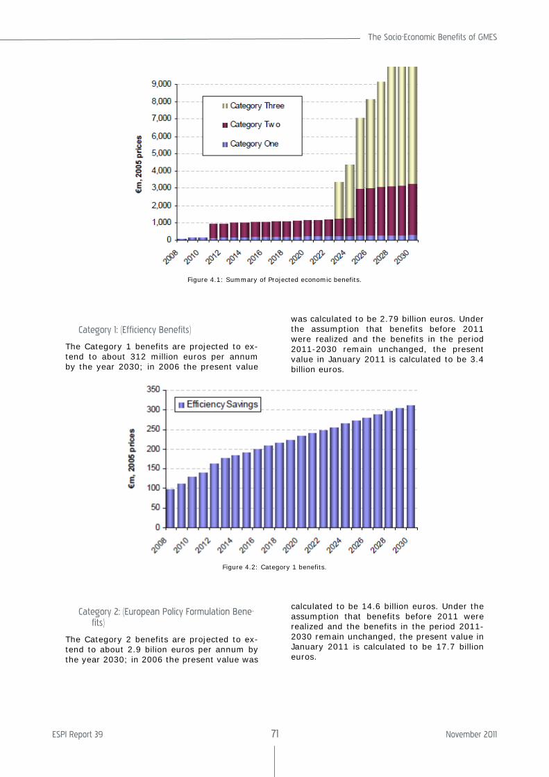
The Socio-Economic Benefits of GMES
ESPI Report 39 71 November 2011
Figure 4.1: Summary of Projected economic benefits.
Category 1: (Efficiency Benefits)
The Category 1 benefits are projected to ex-tend to about 312 million euros per annum by the year 2030; in 2006 the present value
was calculated to be 2.79 billion euros. Under the assumption that benefits before 2011 were realized and the benefits in the period 2011-2030 remain unchanged, the present value in January 2011 is calculated to be 3.4 billion euros.
Figure 4.2: Category 1 benefits.
Category 2: (European Policy Formulation Bene-fits)
The Category 2 benefits are projected to ex-tend to about 2.9 bilion euros per annum by the year 2030; in 2006 the present value was
calculated to be 14.6 billion euros. Under the assumption that benefits before 2011 were realized and the benefits in the period 2011-2030 remain unchanged, the present value in January 2011 is calculated to be 17.7 billion euros.
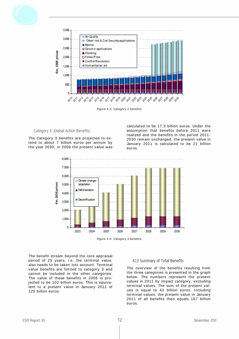
ESPI Report 39 72 November 2011
Figure 4.3: Category 2 benefits.
Category 3: (Global Action Benefits)
The Category 3 benefits are projected to ex-tend to about 7 billion euros per annum by the year 2030; in 2006 the present value was
calculated to be 17.3 billion euros. Under the assumption that benefits before 2011 were realized and the benefits in the period 2011-2030 remain unchanged, the present value in January 2011 is calculated to be 21 billion euros.
Figure 4.4: Category 3 benefits.
The benefit stream beyond the core appraisal period of 25 years, i.e. the terminal value, also needs to be taken into account. Terminal value benefits are limited to category 3 and cannot be included in the other categories. The value of these benefits in 2006 is pro-jected to be 102 billion euros. This is equiva-lent to a present value in January 2011 of 125 billion euros.
4.1.3 Summary of Total Benefits
The overview of the benefits resulting from the three categories is presented in the graph below. The numbers represent the present values in 2011 by impact category, excluding terminal values. The sum of the present val-ues is equal to 42 billion euros. Including terminal values, the present value in January 2011 of all benefits then equals 167 billion euros.
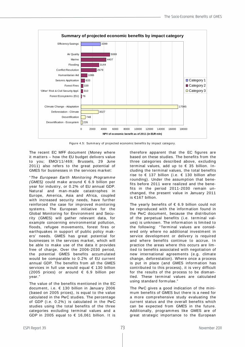
The Socio-Economic Benefits of GMES
ESPI Report 39 73 November 2011
Summary of projected economic benefits by impact category
226
748
3027
17045
76
310
339
633
1086
2679
3144
4407
5069
3399
0 2000 4000 6000 8000 10000 12000 14000 16000 18000
Desertification - Ecosystem
Desertification
Deforestation - Climate
Climate Change - Adaptation
Forest Ecosystems (EU)
‘Other’ Risk & Civil Security Appl.
Forest Fires
Seismic Application
Humanitarian Aid
Conflict Resolution
Flooding
Marine
Air Quality
Efficiency Savings
NPV of economic benefit as of 2011 (in EUR mln)
Category 1Category 2Category 3
Figure 4.5: Summary of projected economic benefits by impact category.
The recent EC MFF document (Money where it matters – how the EU budget delivers value to you; EMO/11/469; Brussels, 29 June 2011) also refers to the great potential of GMES for businesses in the services market:
“The European Earth Monitoring Programme (GMES) could make around € 6.9 billion per year for industry, or 0.2% of EU annual GDP. Natural and man-made catastrophes in Europe, America, Asia and Africa, coupled with increased security needs, have further reinforced the case for improved monitoring systems. The European initiative for the Global Monitoring for Environment and Secu-rity (GMES) will gather relevant data, for example concerning environmental pollution, floods, refugee movements, forest fires or earthquakes in support of public policy mak-ers’ needs. GMES has great potential for businesses in the services market, which will be able to make use of the data it provides free of charge. Over the 2006-2030 period, the potential GMES benefits accumulated would be comparable to 0.2% of EU current annual GDP. The benefits from all the GMES services in full use would equal € 130 billion (2005 prices) or around € 6.9 billion per year.”
The value of the benefits mentioned in the EC document, i.e. € 130 billion in January 2006 (based on 2005 prices), is equal to the value calculated in the PwC studies. The percentage of GDP (i.e. 0.2%) is calculated in the PwC studies using the total benefits of the three categories excluding terminal values and a GDP in 2005 equal to € 16,061 billion. It is
therefore apparent that the EC figures are based on these studies. The benefits from the three categories described above, excluding terminal values, add up to € 35 billion. In-cluding the terminal values, the total benefits rise to € 137 billion (i.e. € 130 billion after rounding). Under the assumption that bene-fits before 2011 were realized and the bene-fits in the period 2011-2030 remain un-changed, the present value in January 2011 is €167 billion.
The yearly benefits of € 6.9 billion could not be reproduced with the information found in the PwC document, because the distribution of the perpetual benefits (i.e. terminal val-ues) is unknown. The information is limited to the following: “Terminal values are consid-ered only where no additional investment in service development or delivery is required and where benefits continue to accrue. In practice the areas where this occurs are lim-ited to benefits associated with negotiation of new international agreements (e.g. climate change, deforestation). Where once a process is put in place (and GMES information has contributed to this process), it is very difficult for the results of the process to be disman-tled. These terminal values are calculated using standard formulae.”
The PwC gives a good indication of the mini-mum benefits of GMES but there is a need for a more comprehensive study evaluating the current status and the overall benefits which can be expected from GMES in the future. Additionally, programmes like GMES are of great strategic importance to the European
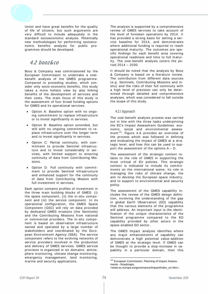
ESPI Report 39 74 November 2011
Union and have great benefits for the quality of life of citizens, but such arguments are very difficult to include adequately in the standard socioeconomic analysis. Potentially new methodologies for performing socioeco-nomic benefits analysis for public pro-grammes should be developed.
4.2 booz&co
Booz & Company was commissioned by the European Commission to undertake a cost-benefit analysis of the GMES programme. Compared to preceding studies, which con-sider only socio-economic benefits, this study takes a more holistic view by also linking benefits of the development of services and their costs. The main focus of this study is the assessment of four broad funding options for GMES and its operational services:
• Option A: Baseline option with no ongo-ing commitment to replace infrastructure or to invest significantly in services.
• Option B: Baseline option extended, but still with no ongoing commitment to re-place infrastructure over the longer term and to invest significantly in services.
• Option C: Partial continuity, with com-mitment to provide Sentinel infrastruc-ture and to invest considerably in ser-vices, with limited support to ensuring continuity of data from Contributing Mis-sions.
• Option D: Full continuity with commit-ment to provide Sentinel infrastructure and enhanced support for the continuity of data from Contributing Mission with full investment in services.
Each option contains profiles of investment in the three main building blocks of GMES: (i) the space component, (ii) the in-situ compo-nent and (iii) the service component. In its operational configuration, the GMES Space Component (GSC) will rely on data provided by dedicated GMES missions (the Sentinels) and the Contributing Missions from national or commercial providers. The in-situ compo-nent is based on observation infrastructure owned and operated by a large number of stakeholders and coordinated by the Euro-pean Environment Agency (EEA). The service component refers to the evolving networks of service providers involved in the production and delivery of GMES services. GMES service provision is organized in six domains: atmos-phere monitoring, climate change monitoring, emergency management, land monitoring, marine and security applications.
The analysis is supported by a comprehensive review of GMES services to take account of the level of foreseen operations by 2014. It has provided a strong basis for setting a ser-vice baseline for 2014, and demonstrates where additional funding is required to reach operational maturity. The outcomes are spe-cific findings for each benefit area covering operational readiness and time to full matur-ity. The cost-benefit analysis covers the pe-riod 2014 – 2030.
It should be noted that the analysis by Booz & Company is based on a literature review. The contribution from different data sources (e.g. Sentinels, Contributing Missions and in-situ) and the risks of their full continuity with a high level of precision can only be deter-mined through detailed and comprehensive analyses, which was considered to fall outside the scope of this study.
4.2.1 Approach
The cost-benefit analysis process was carried out in line with the three tasks underpinning the EC’s Impact Assessment Guidelines: eco-nomic, social and environmental assess-ment144. Figure 4.6 provides an overview of the process which was followed in defining and evaluating the impact of GMES at a stra-tegic level, and how this can be used to sup-port the assessment of the options A – D.
The assessment of the strategic context re-lates to the role of GMES in supporting the most critical of EU policies. This strategic context is indicated to include its commit-ments on the international scene, its role in managing the risks of climate change, the aim to develop the European space industry, and to support to environmental and security policy.
The assessment of the GMES capability in-cludes the review of the GMES design defini-tion, involving the understanding of the gap in global Earth Observation (EO) capability that the various elements of the programme will address. An important input is the identi-fication of the unique characteristics of the Sentinel programme compared to the EO capability provided by other actors in the space-enabled EO sector.
The GMES impact analysis identifies where any major enhancements of capability can demonstrate a high potential value-addition of GMES at the strategic level. If GMES can be thought to provide a step-increase in ca-pability in a particular domain, then this
144 European Commission. Planning of Impact Assess-ments - Roadmaps. <www.ec.europa.eu/governance/impact/index_en.htm>.
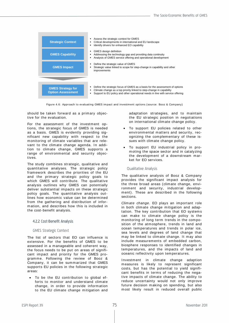
The Socio-Economic Benefits of GMES
ESPI Report 39 75 November 2011
should be taken forward as a primary objec-tive for the evaluation.
For the assessment of the investment op-tions, the strategic focus of GMES is needed as a basis. GMES is evidently providing sig-nificant new capability with respect to the monitoring of climate variables that are rele-vant to the climate change agenda. In addi-tion to climate change, GMES supports a range of environmental and security objec-tives.
The study combines strategic, qualitative and quantitative analyses. The strategic policy framework describes the priorities of the EU and the primary strategic policy goals to which GMES will contribute. The qualitative analysis outlines why GMES can potentially deliver substantial impacts on these strategic policy goals. The quantitative analysis out-lines how economic value can be determined from the gathering and distribution of infor-mation, and describes how this is included in the cost-benefit analysis.
4.2.2 Cost-Benefit Analysis
GMES Strategic Context
The list of sectors that EO can influence is extensive. For the benefits of GMES to be assessed in a manageable and coherent way, the focus needs to be put on areas of signifi-cant impact and priority for the GMES pro-gramme. Following the review of Booz & Company, it can be summarized that GMES supports EU policies in the following strategic areas:
• To be the EU contribution to global ef-forts to monitor and understand climate change, in order to provide information to the EU climate change mitigation and
adaptation strategies, and to maintain the EU strategic position in negotiations on international climate change policy.
• To support EU policies related to other environmental matters and security, rec-ognizing the complementary of these is-sues with climate change policy.
• To support EU industrial policy in pro-moting the space sector and in catalyzing the development of a downstream mar-ket for EO services.
Qualitative Analysis
The qualitative analysis of Booz & Company provides the significant impact analysis for the three broad areas (climate change, envi-ronment and security, industrial develop-ment). These are described in the following sections.
Climate change. EO plays an important role in both climate change mitigation and adap-tation. The key contribution that EO systems can make to climate change policy is the monitoring of long term trends in the compo-sition of the atmosphere, trends in land and ocean temperatures and trends in polar ice, sea levels and degrees of land change that may be linked to climate change. It may also include measurements of embedded carbon, biosphere responses to identified changes in temperatures, and the impacts of land and oceanic reflectivity upon temperatures.
Investment in climate change adaption measures is likely to represent significant costs, but has the potential to yield signifi-cant benefits in terms of reducing the nega-tive impacts of climate change. The ability to reduce uncertainty would not only improve future decision making on spending, but also most likely result in reduced overall public
Strategic Context
GMES Capability
GMES Impact
GMES Strategy forOption Assessment
Assess the strategic context for GMESCritical developments in international and EU landscapeIdentify drivers for enhanced EO capability
GMES design definitionAddressing the technology gap and providing data continuityAnalysis of GMES service offering and operational development
Define the strategic value of GMESStrategic value linked to scope for step-change in capability and other improvements
Define the strategic focus of GMES as a basis for the assessment of optionsClimate change as a top priority linked to step-change in capabilitySupport to EU policy and other operational needs in line with service offering
Figure 4.6: Approach to evaluating GMES impact and investment options (source: Booz & Company)
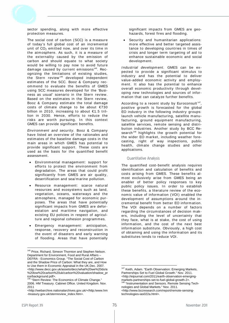
ESPI Report 39 76 November 2011
sector spending, along with more effective protection measures.
The social cost of carbon (SCC) is a measure of today’s full global cost of an incremental unit of CO2 emitted now, and over its time in the atmosphere. As such, it is a measure of the externality caused by the emission of carbon and should equate to what society would be willing to pay now to avoid future damage caused by current emissions145. Rec-ognizing the limitations of existing studies, the Stern review146 developed independent estimates of the SCC. Booz & Company rec-ommend to evaluate the benefits of GMES using SCC measures developed for the ‘Busi-ness as usual’ scenario in the Stern review. Based on the estimates in the Stern review, Booz & Company estimate the total damage costs of climate change to be about €730 billion in 2010, increasing to about €1.5 tril-lion in 2030. Hence, efforts to reduce the risks are worth pursuing. In this context GMES can provide significant benefits.
Environment and security. Booz & Company have listed an overview of the rationales and estimates of the baseline damage costs in the main areas in which GMES has potential to provide significant support. These costs are used as the basis for the quantified benefit assessment.
• Environmental management: support for efforts to protect the environment from degradation. The areas that could profit significantly from GMES are air quality, desertification and sea/marine pollution.
• Resource management: scarce natural resources and ecosystems such as land, vegetation, oceans, waterways and the atmosphere, managed for economic pur-poses. The areas that have potentially significant impacts from GMES are defor-estation and maritime navigation, and existing EU policies in respect of agricul-ture and regional cohesion programmes.
• Emergency management: anticipation, response, recovery and reconstruction in the event of disasters and early warning of flooding. Areas that have potentially
145 Price, Richard, Simeon Thornton and Stephen Nelson. Department for Environment, Food and Rural Affairs – DEFRA - Economics Group. “The Social Cost of Carbon and the Shadow Price of Carbon: What they are, and How to Use them in Economic Appraisal in the UK.Dec. 2007. <http://www.decc.gov.uk/assets/decc/what%20we%20do/a%20low%20carbon%20uk/carbon%20valuation/shadow_price/background.pdf>. 146 “Stern Review: The Economics of Climate Change.” 2006. HM Treasury. Cabinet Office. United Kingdom. Nov. 2011 <http://webarchive.nationalarchives.gov.uk/+/http:/www.hm-treasury.gov.uk/sternreview_index.htm>.
significant impacts from GMES are geo-hazards, forest fires and flooding.
• Security and humanitarian applications: more effective and better targeted assis-tance to developing countries in times of crisis and longer term targeting of aid to enhance sustainable economic and social development.
Industrial development. GMES can be ex-pected to provide a significant stimulus to industry and has the potential to deliver value-added economic activity and employ-ment. It also has the potential to enhance overall economic productivity through devel-oping new technologies and sources of infor-mation that can catalyze further benefits.
According to a recent study by Euroconsult147, positive growth is forecasted for the global EO industry in the following industry groups: launch vehicle manufacturing, satellite manu-facturing, ground equipment manufacturing, satellite services, remote sensing and distri-bution industries. Another study by BCC Re-search148 highlights the growth potential for the wider EO market, including weather fore-casting, right of way inspections, public health, climate change studies and other applications.
Quantitative Analysis
The quantified cost-benefit analysis requires identification and calculation of benefits and costs arising from GMES. These benefits al-most exclusively arise from GMES being an enabler of better policy responses to key public policy issues. In order to establish these benefits, a literature review of the eco-nomic value of information (VOI) enabled the development of assumptions around the in-cremental benefit from better EO information. The VOI depends on a number of factors regarding the circumstances of decision mak-ers, including the level of uncertainty that they face, what is at stake, the cost of using information, and the cost of the next best information substitute. Obviously, a high cost of obtaining and using the information and its substitutes tends to reduce VOI.
147 Keith, Adam. “Earth Observation: Emerging Markets, Partnerships Set to Fuel Global Growth.” Nov. 2011. <http://eijournal.com/2011/earth-observation-emerging-markets-partnerships-set-to-fuel-global-growth-2>. 148 “Instrumentation and Sensors. Remote Sensing Tech-nologies and Global Markets.” Nov. 2011. <http://www.bccresearch.com/report/remote-sensing-technologies-ias022a.html>.
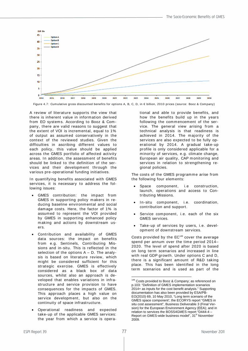
The Socio-Economic Benefits of GMES
ESPI Report 39 77 November 2011
A review of literature supports the view that there is inherent value in information derived from EO systems. According to Booz & Com-pany, there are valid reasons to suggest that the extent of VOI is incremental, equal to 1% of output as assumed conservatively in the context of the reviewed studies. Given the difficulties in ascribing different values to each policy, this value should be applied across the GMES portfolio of affected activity areas. In addition, the assessment of benefits should be linked to the definition of the ser-vices and their development through the various pre-operational funding initiatives.
In quantifying benefits associated with GMES services, it is necessary to address the fol-lowing issues:
• GMES contribution: the impact from GMES in supporting policy makers in re-ducing baseline environmental and social damage costs. Here, the factor of 1% is assumed to represent the VOI provided by GMES in supporting enhanced policy making and actions by downstream us-ers.
• Contribution and availability of GMES data sources: the impact on benefits from e.g. Sentinels, Contributing Mis-sions and in-situ. This is reflected in the selection of the options A – D. The analy-sis is based on literature review, which might be considered sufficient for this strategic exercise. GMES is effectively considered as a black box of data sources, whilst also an approach is de-veloped that enables variations in infra-structure and service provision to have consequences for the impacts of GMES. This approach places a high value on service development, but also on the continuity of space infrastructure.
• Operational readiness and expected take-up of the applicable GMES services: the year from which a service is opera-
tional and able to provide benefits, and how the benefits build up in the years following the commencement of the ser-vice. The general view arising from a technical analysis is that readiness is achieved in 2014. The majority of the services are also expected to be fully op-erational by 2014. A gradual take-up profile is only considered applicable for a minority of services, e.g. climate change, European air quality, CAP monitoring and services in relation to strengthening re-gional policies.
The costs of the GMES programme arise from the following four elements:
• Space component, i.e construction, launch, operations and access to Con-tributing Missions.
• In-situ component, i.e. coordination, contribution and support.
• Service component, i.e. each of the six GMES services.
• Take-up of services by users, i.e. devel-opment of downstream services.
Costs provided by the EC149 cover the average spend per annum over the time period 2014–2020. The level of spend after 2020 is based on long term scenarios and increased in line with real GDP growth. Under options C and D, there is a significant amount of R&D taking place. This has been identified in the long term scenarios and is used as part of the
149 Costs provided to Booz & Company; as referenced on p.103: “Definition of GMES implementation scenarios 2014+ as inputs for the cost benefit analysis.” Supporting documentation has also been provided by ESA/PB-EO(2010) 69, 10 May 2010, “Long term scenario of the GMES space component’; the ECORYS report “GMES in situ cost assessment”, Business Deliverable 3 (Final Ver-sion) for the European Environment Agency (EEA); and in relation to services the BOSS4GMES report “D444-4 – Report on GMES-wide business model”, 31st November 2009.
Figure 4.7: Cumulative gross discounted benefits for options A, B, C, D, in € billion, 2010 prices (source: Booz & Company)
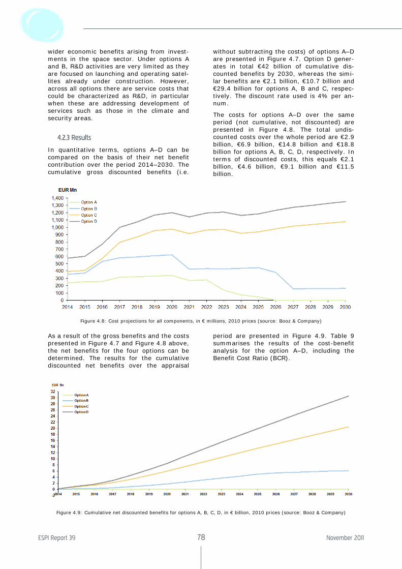
ESPI Report 39 78 November 2011
wider economic benefits arising from invest-ments in the space sector. Under options A and B, R&D activities are very limited as they are focused on launching and operating satel-lites already under construction. However, across all options there are service costs that could be characterized as R&D, in particular when these are addressing development of services such as those in the climate and security areas.
4.2.3 Results
In quantitative terms, options A–D can be compared on the basis of their net benefit contribution over the period 2014–2030. The cumulative gross discounted benefits (i.e.
without subtracting the costs) of options A–D are presented in Figure 4.7. Option D gener-ates in total €42 billion of cumulative dis-counted benefits by 2030, whereas the simi-lar benefits are €2.1 billion, €10.7 billion and €29.4 billion for options A, B and C, respec-tively. The discount rate used is 4% per an-num.
The costs for options A–D over the same period (not cumulative, not discounted) are presented in Figure 4.8. The total undis-counted costs over the whole period are €2.9 billion, €6.9 billion, €14.8 billion and €18.8 billion for options A, B, C, D, respectively. In terms of discounted costs, this equals €2.1 billion, €4.6 billion, €9.1 billion and €11.5 billion.
Figure 4.8: Cost projections for all components, in € millions, 2010 prices (source: Booz & Company)
As a result of the gross benefits and the costs presented in Figure 4.7 and Figure 4.8 above, the net benefits for the four options can be determined. The results for the cumulative discounted net benefits over the appraisal
period are presented in Figure 4.9. Table 9 summarises the results of the cost-benefit analysis for the option A–D, including the Benefit Cost Ratio (BCR).
Figure 4.9: Cumulative net discounted benefits for options A, B, C, D, in € billion, 2010 prices (source: Booz & Company)
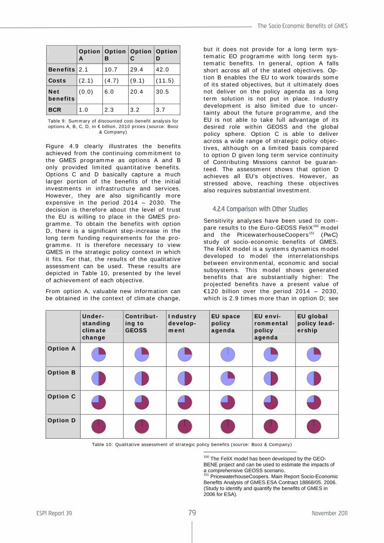
The Socio-Economic Benefits of GMES
ESPI Report 39 79 November 2011
Option A
Option B
Option C
Option D
Benefits 2.1 10.7 29.4 42.0
Costs (2.1) (4.7) (9.1) (11.5)
Net benefits
(0.0) 6.0 20.4 30.5
BCR 1.0 2.3 3.2 3.7
Table 9: Summary of discounted cost-benefit analysis for options A, B, C, D, in € billion, 2010 prices (source: Booz
& Company)
Figure 4.9 clearly illustrates the benefits achieved from the continuing commitment to the GMES programme as options A and B only provided limited quantitative benefits. Options C and D basically capture a much larger portion of the benefits of the initial investments in infrastructure and services. However, they are also significantly more expensive in the period 2014 – 2030. The decision is therefore about the level of trust the EU is willing to place in the GMES pro-gramme. To obtain the benefits with option D, there is a significant step-increase in the long term funding requirements for the pro-gramme. It is therefore necessary to view GMES in the strategic policy context in which it fits. For that, the results of the qualitative assessment can be used. These results are depicted in Table 10, presented by the level of achievement of each objective.
From option A, valuable new information can be obtained in the context of climate change,
but it does not provide for a long term sys-tematic EO programme with long term sys-tematic benefits. In general, option A falls short across all of the stated objectives. Op-tion B enables the EU to work towards some of its stated objectives, but it ultimately does not deliver on the policy agenda as a long term solution is not put in place. Industry development is also limited due to uncer-tainty about the future programme, and the EU is not able to take full advantage of its desired role within GEOSS and the global policy sphere. Option C is able to deliver across a wide range of strategic policy objec-tives, although on a limited basis compared to option D given long term service continuity of Contributing Missions cannot be guaran-teed. The assessment shows that option D achieves all EU’s objectives. However, as stressed above, reaching these objectives also requires substantial investment.
4.2.4 Comparison with Other Studies
Sensitivity analyses have been used to com-pare results to the Euro-GEOSS FeliX150 model and the PricewaterhouseCoopers151 (PwC) study of socio-economic benefits of GMES. The FeliX model is a systems dynamics model developed to model the interrelationships between environmental, economic and social subsystems. This model shows generated benefits that are substantially higher: The projected benefits have a present value of €120 billion over the period 2014 – 2030, which is 2.9 times more than in option D; see
150 The FeliX model has been developed by the GEO-BENE project and can be used to estimate the impacts of a comprehensive GEOSS scenario. 151 PricewaterhouseCoopers. Main Report Socio-Economic Benefits Analysis of GMES.ESA Contract 18868/05. 2006. (Study to identify and quantify the benefits of GMES in 2006 for ESA).
Under-standing climate change
Contribut-ing to GEOSS
Industry develop-ment
EU space policy agenda
EU envi-ronmental policy agenda
EU global policy lead-ership
Option A
Option B
Option C
Option D
Table 10: Qualitative assessment of strategic policy benefits (source: Booz & Company)
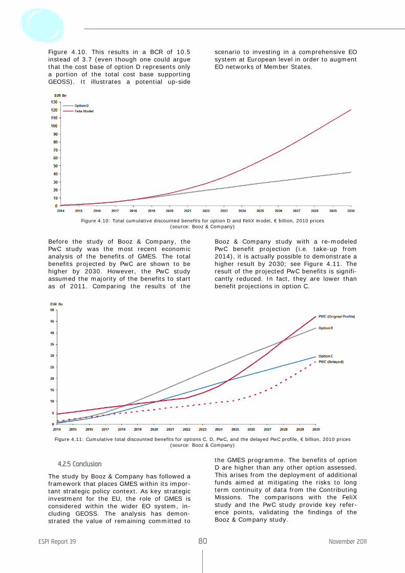
ESPI Report 39 80 November 2011
Figure 4.10. This results in a BCR of 10.5 instead of 3.7 (even though one could argue that the cost base of option D represents only a portion of the total cost base supporting GEOSS). It illustrates a potential up-side
scenario to investing in a comprehensive EO system at European level in order to augment EO networks of Member States.
Figure 4.10: Total cumulative discounted benefits for option D and FeliX model, € billion, 2010 prices (source: Booz & Company)
Before the study of Booz & Company, the PwC study was the most recent economic analysis of the benefits of GMES. The total benefits projected by PwC are shown to be higher by 2030. However, the PwC study assumed the majority of the benefits to start as of 2011. Comparing the results of the
Booz & Company study with a re-modeled PwC benefit projection (i.e. take-up from 2014), it is actually possible to demonstrate a higher result by 2030; see Figure 4.11. The result of the projected PwC benefits is signifi-cantly reduced. In fact, they are lower than benefit projections in option C.
Figure 4.11: Cumulative total discounted benefits for options C, D, PwC, and the delayed PwC profile, € billion, 2010 prices (source: Booz & Company)
4.2.5 Conclusion
The study by Booz & Company has followed a framework that places GMES within its impor-tant strategic policy context. As key strategic investment for the EU, the role of GMES is considered within the wider EO system, in-cluding GEOSS. The analysis has demon-strated the value of remaining committed to
the GMES programme. The benefits of option D are higher than any other option assessed. This arises from the deployment of additional funds aimed at mitigating the risks to long term continuity of data from the Contributing Missions. The comparisons with the FeliX study and the PwC study provide key refer-ence points, validating the findings of the Booz & Company study.
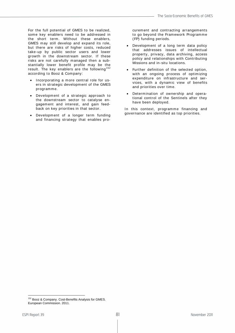
The Socio-Economic Benefits of GMES
ESPI Report 39 81 November 2011
For the full potential of GMES to be realized, some key enablers need to be addressed in the short term. Without these enablers, GMES may still develop and expand its role, but there are risks of higher costs, reduced take-up by public sector users and lower growth in the downstream sector. If these risks are not carefully managed then a sub-stantially lower benefit profile may be the result. The key enablers are the following152 according to Booz & Company:
• Incorporating a more central role for us-ers in strategic development of the GMES programme.
• Development of a strategic approach to the downstream sector to catalyse en-gagement and interest, and gain feed-back on key priorities in that sector.
• Development of a longer term funding and financing strategy that enables pro-
152 Booz & Company. Cost-Benefits Analysis for GMES. European Commission. 2011.
curement and contracting arrangements to go beyond the Framework Programme (FP) funding periods.
• Development of a long term data policy that addresses issues of intellectual property, privacy, data archiving, access policy and relationships with Contributing Missions and in-situ locations.
• Further definition of the selected option, with an ongoing process of optimizing expenditure on infrastructure and ser-vices, with a dynamic view of benefits and priorities over time.
• Determination of ownership and opera-tional control of the Sentinels after they have been deployed.
In this context, programme financing and governance are identified as top priorities.
ESPI Report 39 82 November 2011
5. Conclusions and Recommendations
5.1 Overview
Disasters have a significant socioeconomic effect on economy and societies. Even though there are no internationally agreed minimum criteria for an event to be classified as a dis-aster, the number of reported damage caused by disasters during the last decade has doubled compared to those reported in the previous decade. There are various rea-sons that can explain this increase. In the first instance, the increase is probably due to the population growth and assets with higher economic value in exposed areas and the possibility to better assess the impacted ar-eas and report correspondingly. There is some evidence that climate change may con-tribute to the increasing frequency and inten-sity of natural hazards, as well. During the last decade amongst the top ten countries of very high human development by disaster occurrence in the world are the European Union Member States Germany with 29.9 billion US$ of losses, France with 17.9 billion US$, Italy with 13.4 billion US$, United King-dom with 12.1 billion US$ and Greece with 2.9 billion US$ of losses in damages. Overall in Europe153 during the last decade almost 100,000 fatalities occurred, more than 11 million people were affected, and reported losses amounted to more than 200 billion EUR. The first most important natural disas-ter in Europe regarding economic losses is flooding resulting in 52.173 billion EUR of losses over the decade. The second most important are storms resulting in 44.338 billion EUR losses, and the third is earth-quakes with 29.205 billion EUR losses. After that follows extreme temperature events with 9.962 billion EUR, forest fires with 6.917 bil-lion EUR and drought with 4.940 billion EUR losses154. Losses due to avalanches, land-slides, and volcanoes are of a smaller scale.
The first study at the European level of the public opinion on civil protection was com-
153 European Environment Agency (EEA) Mapping the Impacts of Natural Hazards and Technological Accidents in Europe. EEA Technical Report 13. 2010: 66 – 68. 154 EFFIS, 2010.
pleted in 2009155, focusing on risk perception in natural and man made disasters and the perception of European or national ap-proaches to civil protection in the various stages of the disaster cycle. The research showed that the perception of risk by the public is slightly different than fact. The top five perceived risks were flooding, storms, industrial accidents, forest fires and earth-quakes. Naturally, the distribution varies from country to country in the EU. Regarding the approaches to civil protection, an over-whelming majority of Europeans believe that more should be done on European level by setting up a reserve of assets such as fire fighting planes, flood water pumps and spe-cially trained staff regarding response, pre-paredness and prevention to support Member States efforts. Additionally, the majority be-lieves there should be at EU level develop-ment of common warning signals for emer-gencies, common risk measures as they exist for floods and common standards. Another study published the same year shows Euro-peans believe with an overwhelming majority that it is important for Europe to develop Earth observation systems to monitor the environment including natural disasters156. However, even though the majority is aware that Europe is developing its own Earth ob-servation systems, it would appear necessary that efforts be made to raise further the awareness about them.
There are a number of regulatory and policy approaches in Europe that impact the disas-ter cycle. The European Commission is cur-rently developing guidelines on disaster risk management. Disaster risk reduction and management has shifted from a response-oriented approach towards an integrated risk management approach. This includes preven-tion, preparedness, response and recovery. In this context it is imperative to enhance early warning systems, public awareness, evacuation procedures and decision support tools. Moreover, protection measures can be improved, e.g. in terms of robustness of in-
155 European Commission. Special Eurobarometer. Civil Protection. Full Report. Special Eurobarometer 328/Wave 72.2 – TNS Opinion & Social. Nov. 2009. 156 European Commission. Flash Eurobarometer. Space activities of the European Union. Analytical Report. Flash Eurobarometer272- The Gallup Organisation Hungary. Oct. 2009.
The Socio-Economic Benefits of GMES
ESPI Report 39 83 November 2011
frastructure and spatial planning. Conse-quently, local risk reduction policies are be-coming more harmonized across Europe.
Earth observation capabilities from the na-tional, European and international communi-ties are used to respond to major disasters around the world including humanitarian aid and security. In case of disasters, there is a need for any type of geo-information that might be available in a short period of time. Additionally, the appropriate information needed for action changes according to the type of the disaster and the disaster cycle phase. Satellite-derived information needs to be used in combination with additional data to present it in a proper geospatial context for the work of civil protection agencies and relief organizations. The most crucial problem is the availability and access to accurate and up-to-date spatial data, particularly in remote regions. Currently, there are still gaps in the information cycle that need to be closed to better incorporate space based, airborne, and ground data in order to have a more effective disaster management response. Thus, there is a need for a comprehensive system that provides information for the various disasters and can cover all phases. The Global Monitor-ing for Environment and Security (GMES) is a programme which will enhance the European capability in particular in the area of remote sensing. Its primary objective is to provide, under European Union control, information services (satellite and in-situ based) which give access to accurate data and information in the field of the environment and security and are tailored to the needs of users. Once this programme is completed, it will provide the most compete information system in the word, providing Earth observation informa-tion and associated applications. Additionally, GMES will be the European contribution to the international efforts to create a Global Earth Observation System of Systems (GEOSS), the Global Climate Observing Sys-tem (GCOS) and the Global Ocean Observing System (GOOS).
There are a lot of discussions related to esti-mations of the socioeconomic benefits of satellites and integrated systems incorporat-ing information from satellite data. The socio-economic benefit of weather forecast infor-mation, which is difficult to assess with preci-sion, is most easily identified at an individual application level. For example, according to Swiss Re157 winter storms have cost on aver-age about 2.6 billion EUR per year in Europe. If, due to preventive actions, weather fore-
157 Swiss, Re. The Effect of Climate Change: Storm Dam-age in Europe on the Rise. 2006. <http://www.preventionweb.net/files/20629_publ06klimaveraenderungen1.pdf>.
casts enable these losses to be reduced by 10% to 50%, the corresponding gain is be-tween 260 and 1,200 million EUR per year. A similar estimation can be made for floods. According to Barredo158 floods in Europe cost on average 4 billion EUR per year159. Assum-ing that the warning reduces losses by 10%, and if only half of the floods are forecast, the benefits from early warnings could reach 200 million Euros per year. Alternatively, if one assumes that a warning emitted 48 hours before a flood enables the overall damage to be reduced by more than 50% (Carsell160) and that 75% of the floods can be forecast, the benefits would reach 1,500 million Euros per year. Thus the combined economic bene-fit to Europe of forecasting floods and storms could lie somewhere between 460 million and 2.7 billion EUR per year.
The detrimental impact of disasters and the economic consequences, demonstrate very clearly the potential for harvesting benefits though avoidance and remediation actions, using systems like GMES. However, specific studies on the socioeconomic impact of GMES were never narrowed only to the disaster area, which is surely one of the richest areas to harvest benefits. Hence, what follows is an analysis of the socioeconomic benefits of GMES in a broader context. If this methodol-ogy would have been applied to the disaster domain covering all disaster areas and the complete disaster cycle, the impact could be expected to have been even more profound.
There are numerous studies that have been conducted over the years analyzing the GMES Services Elements (GSE). ESA has initiated twelve GSE projects, ten in 2003 and two in 2004. These studies focus on costal monitor-ing, forest monitoring, food security, sea ice monitoring, ocean monitoring, humanitarian aid, atmosphere monitoring, urban atlas, land hazard monitoring, natural hazard monitor-ing, floods and fires, monitoring the North, and environmental pressure and state. In 2006 PwC analyzed the potential socioeco-nomic benefits of GMES for the period 2006-2030 by looking at the impact against a base line scenario without availability of GMES and to characterise the benefits of the introduc-tion of GMES with respect to the strategic and political dimension, and to the economic and social dimension. It was very clear that some of the benefits can be quantifiable and contribute to the economic value presented in
158 Barredo.Normalised Flood Losses in Europe: 1970-2006. Nat. Hazards Earth Syst. Sci.2009. 97–104. 159 Discrepancies with the figures given above are ex-plained due to different methodologies and averaging. 160 Carsell, K.M., N. D. Pingel, D.T. Ford.Quantifying the Benefit of a Flood Warning System. Nat. Hazards Rev, 5(3). 2004.131–140.
ESPI Report 39 84 November 2011
the study and that other benefits were very difficult to assess and hence non-quantifiable. This distinction is very important to keep in mind when considering the assessment of public investments where the benefits cannot always be translated into monetary value. In 2011 booz&co made another study on the cost benefits analysis for GMES. Even though booz&co used a different methodology to make the analysis their results were very similar to those of PwC. The main conclusion of both studies was that GMES can enable significant socioeconomic benefits and that it can offer significant strategic and political benefits for Europe.
GMES can contribute to a number of Euro-pean policies such as, environment, climate change, agriculture, energy, fisheries, re-gional development, etc. The potential impact of GMES on the EU’s Common Foreign and Security Policy (CFSP), common commercial policy, development aid and external rela-tions is of great importance. Space assets and applications can contribute to the EU’s external policy through meteorological fore-casting, terrain mapping, intelligence, etc. These capabilities already exist to a certain extent and will be under further development to a large extent through GMES. GMES can contribute to the reduction of mortality and morbidity in humanitarian response tasks, peacekeeping, deployment of combat forces for crisis management (including peacemak-ing), treaty verification, arms and prolifera-tion control. Stakeholders indicated that GMES would make a maximum contribution over the time period of interest to activities related to Africa. In the area of climate change, it can contribute to reduced levels of scientific uncertainty and to improvement in international action to reduce climate change impact through better adaptation. GMES in-formation will assist in optimizing the invest-ment in climate change management. Addi-tionally, it will allow better management of desertification and reduction of global costs related to desertification. GMES Services for agriculture are mainly based on land cover mapping and change detection. This includes soil monitoring, irrigation pressure mapping and crop monitoring. GMES can provide the necessary tools at the European level for coordination. At the international level, space assets can facilitate factoring environmental and socioeconomic considerations into pro-moting sustainable and responsible fisheries policies. It will improve the enforcement of international agreements on fishing quotas and on fishing practices in general. An analy-sis was also presented about regional and urban development, ecosystems and biodi-versity, deforestation, air quality, land use
planning and water quality, marine and costal environment, and risk and civil protection.
According to the PwC study, potential GMES benefits are divided into three categories in order to better reflect the different time-scales, policy processes, external dependen-cies and uncertainties involved in GMES. Category one focuses on efficiency benefits related to improved cost effectiveness of implementing, enforcing or assessing policies that are currently in place. Category two fo-cuses on European policy formulation benefits related to improved definition and implemen-tation of new European policies for which GMES information would be used from the early policy formulation stages onwards. Category three focuses on global action bene-fits related to the use of GMES information in formulating, improving and implementing global policy agreements (e.g. for climate change, desertification, deforestation). The value of all these benefits in 2006 was pro-jected to be 102 billion Euros. This is equiva-lent to a present value in January 2011 of 125 billion Euros. Including terminal161 values, the present value in January 2011 of all benefits equals 167 billion Euros.
According to the booz&co study, the main focus for the assessment were four broad funding options for GMES and its operational services. Option A: Baseline option with no ongoing commitment to replace infrastructure or to invest significantly in services. Option B: Baseline option extended, but still with no ongoing commitment to replace infrastructure over the longer term and to invest signifi-cantly in services. Option C: Partial continu-ity, with commitment to provide Sentinel infrastructure and to invest considerably in services, with limited support to ensuring continuity of data from Contributing Missions. Option D: Full continuity with commitment to provide Sentinel infrastructure and enhanced support for the continuity of data from Con-tributing Mission with full investment in ser-vices. The qualitative analysis of booz&co provides significant impact analysis for the three broad areas: climate change, environ-ment and security, industrial development. The quantitative analysis took into account two scenarios: the static scenario and the dynamic one. The static scenario does not take into consideration the interrelationship between environmental, economic and social ecosystems. This gives a cost benefit ratio for option D (full continuity of GMES) a cost benefit ratio (CBR) of 3.7. When these inter-relationship are taken into consideration in the dynamic model, the generated benefits
161 The terminal value includes benefit stream beyond the core appraisal period of 25 years.
The Socio-Economic Benefits of GMES
ESPI Report 39 85 November 2011
are substantially higher. The projected bene-fits have a present value of €120 billion over the period 2014 – 2030, which is 2.9 times more than in option D. This results in a BCR of 10.5 instead of 3.7. It illustrates a poten-tial up-side scenario to investing in a com-prehensive EO system at European level in order to augment EO networks of Member States.
The PwC study does not fully capture all the areas of possible benefit of GMES e.g. in hu-manitarian aid a focus on Africa was set, in security only few areas are covered e.g. food security. The same applies for the booz&co study which also does not capture all areas. Thus, they give a good indication of the minimum benefits of GMES but a more com-prehensive study evaluating the current status and the overall benefits that can be expected from GMES in the future would be welcome.
Finally, programmes like GMES are of great strategic importance to the European Union and will greatly benefit the quality of life of the citizens also in a non-economic sense. Such benefits are very difficult to include adequately in a standard socioeconomic analysis. Potentially new methodologies for performing socioeconomic benefits analysis for public programmes might have to be de-veloped.
5.2 Analysis and Recom-mendations by Factor
The key findings of the study are presented according to political, economic, social, tech-nological and legal (PESTL) environmental factors.
Political
The main challenges of the EU today include natural disasters, which impact on the sus-tainable development of Europe. The risks differ in the areas of Europe, the Member States and regions of Member States. This has a negative impact on European integra-tion. Natural disasters and in particular floods have trans-boundary impacts which require a pan-European approach. GMES is primarily a strategic programme of the European Union aimed at providing, under the Union’s con-trol, information services that give autono-mous and independent access to accurate data and information in the field of the envi-ronment and security to support decision makers in developing, implementing and monitoring policies. Its strategic importance is also related to the role of the Union and its
Member States as a global actor in relation to its international obligations e.g. for the envi-ronment and climate change relative to the Kyoto Protocol; contributing ‘GMES for Africa’ in order to assist sustainable development and achieving the Millennium Development Goals through the EU-Africa partnership.
GMES can thus produce significant socioeco-nomic benefits and can offer significant stra-tegic and political benefits for Europe. This was the major conclusion of the PWC study and confirmed by the booz&co study. The strategic and political benefits for Europe are inherently non-quantifiable, nevertheless they are a capital element of the GMES bene-fit area. They relate to European leadership and have a global impact with long-term im-plications for the quality of life of European citizens. The main not-quantifiable benefits are: a) access to independent information to support European interests and b) European autonomy in critical technologies and capa-bilities.
There is a need to:
• Confirm political commitment. The politi-cal leadership of Europe and decision makers at the European, national and lo-cal level need to confirm their commit-ment to the need for the full develop-ment and implementation of GMES as part of the essential infrastructure in Europe for non-dependence and as part of European strategic assets. In particu-lar now that the economic crisis requires budget cuts across various areas thor-ough Europe it is essential to confirm this commitment for programmes like GMES which apart from an quantifiable eco-nomic benefit, also provide significant strategic and political benefits.
• Capture adequately the policy objectives GMES can serve. The GMES can serve various European policies in all main pol-icy areas of the Union and those of the member states, like agriculture, energy, environment, fisheries, external, regional development, security etc. These should be thoroughly examined, beyond what has been done today. The policy objec-tives need to be translated to concrete applications with action plans for imple-mentation.
• Enhance cooperation and coordination between the EU and Member States. The EU and the Member States should work together in coordinating their needs and jointly develop applications projects to utilize the potential of GMES to meet pol-icy objectives and improve the lives of citizens in particular in the field of civil protection where the citizen expect an in-
ESPI Report 39 86 November 2011
tegrated European approach throughout the entire disaster management cycle.
• Ensure successful governance. Politicians and decision makers have to ensure and safeguard that successful governance is implemented for the GMES programme and its use in civil protection taking into consideration the various stakeholders and the necessary time frames.
• Confirm International commitments. The Union and its Member States should en-sure that GMES is fully implemented in order to support the political commit-ments made to the international commu-nity e.g. Kyoto Protocal, EU and Africa with GMES for Africa and EGNOS for Af-rica etc.
Economic
Analysis by re-insurance companies shows that the economic impact of disasters and requests for support funds are constantly increasing in Europe. This is largely due to the fact that assets are of high value in de-veloped regions like Europe. This requires a European approach with higher focus on pre-vention and reduction of vulnerability. Cur-rently greater focus is still placed on disaster-driven response on a case by case basis.
There is a lot of debate about cost-benefit analysis (CBA), in particular about what the costs are that need to be invested, how the benefits will arise in terms of direct and indi-rect future cash flows, how the present value of the costs and benefits can be determined, and how the results between different analy-ses can be compared. Nevertheless, irrele-vant of the different methodologies used, the studies by PwC and booz & Company come up with similar results: the discounted bene-fits aggregate in the order of €120 billion over the period 2014 – 2030; and based on the same cost base in both studies, the bene-fit-cost ratio (BCR) is about 10. This implies that for every 1 euro of tax payers money invested in GMES, the citizen receives the equivalent of 10 euros public benefits back. It should be made clear that this does not translate to economic revenues in companies. Thus, this give a clear indication that such projects should remain under public funding as they give clear benefit to the citizens.
For better comparisons between different studies of socio-economic benefits, standard-ized coherent methods are required. Compa-rable CBA standards will enable a fair judg-ment of public investments taking into con-sideration their specificities and their impor-tance for strategic and political reasons, which are not quantifiable today. Standardi-zation of CBA methods is needed within dif-
ferent sectors, such as energy, agriculture, transport, etc., as well as cross-sectorial.
The PWC and booz&co give a good indication of the minimum benefits of GMES and con-firm the appropriateness of investing in this programme. However, there might be a need for a more comprehensive study evaluating the current status and the overall benefits that can be expected from GMES in the future with a broader approach including benefits in a systematic way in other areas e.g. agricul-ture, fisheries, transport, etc which would increase the benefits this programme will bring. It is to be noted that GMES is the only programme that has funds to build the satel-lites, launch, and access and integrate to the Member State missions but does not have money for the operational phase. It is impor-tant that the financing of the programme is guaranteed throughout the operation in order to ensure that investments made so far are not lost. Failure to ensure this will have im-portant implications on data gaps, policies, jobs, business as well as the image of Europe vis-à-vis the international community. There is a need to:
• Ensure the continuation of financing. Adequate financing mechanisms should be used in order to ensure the full devel-opment of GMES programme which should guarantee that it remains a Euro-pean programme in order for all Member States of the European Union to be able to benefit from it.
• Ensure the complete financing of GMES though public funds. The financing of GMES should be ensured by public funds, as the benefits for the citizens are clearly demonstrated both in terms of quantita-tive terms as well as providing strategic and political not-quantifiable benefits. The most preferable option should be that it is financed though the existing fi-nancial instruments of the European Un-ion (i.e. MFF) in order to maintain its European character and guarantee that the benefits are delivered to all European citizens.
• Develop new methodologies for perform-ing socioeconomic benefits analysis for public investments. New methodologies for cost benefit analysis for public in-vestments need to be developed in the European Union which are able to reflect the peculiarities of public funding and are able to incorporate non quantifiable benefits of programmes and projects in-cluding their the strategic and political importance. These methodologies should be standardised across the various sec-tors in order to provide an overview and
The Socio-Economic Benefits of GMES
ESPI Report 39 87 November 2011
allow comparisons between different sec-tors.
• Enhance financial instruments stimulat-ing the development of innovative down-stream applications. The market for Earth observation is growing as well as the market for navigation, positioning and combination of such technologies. Financial instruments should be put in place stimulating the development of novel downstream applications. The fi-nancing of such downstream applications can be based on public private partner-ships or by the involvement of invest-ment banks.
Social
GMES and its applications can assist decision makers and the European citizens in improv-ing everyday life by providing solutions in transport, disaster management, health, working conditions, urban development, en-ergy, environment, safety, etc. The social benefits are not always quantifiable e.g. preservation of attractiveness of costal areas. The European citizens believe by an over-whelming majority that it is important to have a European Earth observation system monitoring our environment and security including natural disasters. They also believe that a more European approach should be taken in the areas of civil protection to show solidarity between the EU countries and to have a more effective result though coordi-nated actions rather than individual actions. However, the information and knowledge they have about the specifics of the European Earth observation systems is limited. Current communication mechanisms are not sufficient regarding programmes like GMES in inform-ing the public about its status and potential benefits. There is a need to:
• Increase awareness and enhance com-munication about the benefits of applica-tions. The stakeholders involved in civil protection and related GMES fields of ap-plication e.g. European Commission, the European Space Agency, European agen-cies, industry, authorities, user commu-nities, industries, should develop appro-priate information mechanisms in order to better communicate the role of Euro-pean capabilities in civil protection and the role of GMES at the European, na-tional and local level.
• Enhance community involvement in user applications. The European citizen’s par-ticipation in the civil protection steward-ship should be encouraged by the crea-tion of innovative user applications. Such systems can be ‘citizens observatories’
based on crowdsourcing which will allow volunteers to participate in data collec-tion for civil protection, and at the same time it will enhance their awareness of the European and national efforts and their participation in supporting policy priorities.
• Enhance the European identity though civil protection and GMES. A pan-European approach to civil protection needs to be enhanced and promoted to the public and its contribution to the European identity should be fostered.
• Enhance demonstration of public bene-fits. In order to maintain the public sup-port for a pan-European approach in civil protection and the need for European earth observation systems like GMES, the results of successful projects which provide benefits for the citizens should be showcased, demonstrating the added value. The benefits of such projects can be expressed either in monetary terms by the cost benefit ratio or by the social and political benefits, which as men-tioned above are not all quantifiable.
Technological
The European citizens are in favour of a more European approach in the area of disaster management. They support setting up re-serve of assets such as fire fighting planes, food, water pumps, and specially trained staff for civil protection tasks. They are also in favour of the development of common risk measures and support the development of European satellites for environment and dis-aster management. Thus, appropriate tech-nologies should be developed to reflect this. The current information regarding data is still scattered, unstructured and lacking com-pleteness in terms of data for the full risk cycle. It is thus important to improve the effort at EU level and in particular to focus on the area of integrated prevention and risk reduction. To date, the use of space based information for applications in the field of disaster management is still underutilised. Until now the focus has been more on tech-nologies for disaster response and less focus has been given to other parts of the disaster cycle like prevention. Thus, a more holistic approach in integrating information in all parts of the disaster cycle should be taken. Additionally, there is integrated information linking other areas like agriculture, fisheries, etc. There is a need to:
• Enhance the development of European assets. Supported by the public opinion the European Union should set up a re-serve of assets such as fire fighting
ESPI Report 39 88 November 2011
planes, food, water pumps and special trained staff for civil protection tasks. The European Union should continue the development of European Earth observa-tion systems like GMES and prepare for the development of new generations of Earth observation systems for monitoring the environment and security.
• Increase the development of user appli-cations and services. The development of user applications making use of GMES services should be enhanced. The user communities e.g. European Union, Mem-ber States, local authorities should be in-volved in defining user needs. The user requirements should in turn be translated into technical requirements for the appli-cation development.
• Enhance the development of integrated applications. Innovative applications combining communication, navigation, positioning and Earth observation with terrestrial technologies should be en-hanced. This can open up new applica-tions in areas such as energy, agricul-ture, environment, humanitarian aid, emergency response, management of re-sources, security, etc and new market opportunities.
• Ensure data harmonisation and stan-dardisation. The European and interna-tional efforts for harmonisation and stan-dardisation of geo-spatial data between developers, operators and service pro-viders should be continued.
• Conduct a systematic assessment of on-going projects. A number of projects have been developed in the field of dis-aster management including applications using data from GMES and there is a need for a systematic assessment of the potential of these projects to further ad-vance beyond the demonstration phase.
Legal
There are a number of regulatory and policy approaches for Europe that impact the disas-ter cycle. Disaster risk reduction and man-agement have shifted from a response-oriented approach towards an integrated risk management approach. This includes preven-tion, preparedness, response and recovery. The local risk reduction regulatory and policy approaches are becoming more harmonized across Europe. However, there is still no co-herent framework, or related information data, for reducing risk and vulnerability Europe-wide. Currently, the European Commission is developing guidelines on disaster risk man-agement. It is imperative to enhance early warning systems, public awareness, evacua-
tion procedures and decision support tools. Additionally, due to lack of government fund-ing, not all countries are able to fully benefit. Such countries are thus, highly dependent on systems from other countries and on European assets for their data. Assets from other coun-tries are mostly accessible in the case of dis-aster but have limited accessibility in the case of prevention. The current uncertainty on funding mechanisms and on governance and data policy issues for programmes like GMES puts at risk particularly the most vulnerable regions and Member States and creates a lack of confidence to the various stakeholders and the public on the European commitments and capability to fulfil local, national, European policies for civil protection and provision of adequate Earth observation data. There is a need to:
• Enhance the development of a common regulatory framework for civil protection. The development of common warning sig-nals for emergencies, common risk meas-ures and common standards should be pursued at the European level. Addition-ally, the efforts should be shifted from a response-oriented approach to an inte-grated management approach all parts of the disaster cycle.
• Implement appropriate regulatory frame-work for GMES. In order to ensure the successful development and implementa-tion of the GMES programme appropriate funding instruments should be used for the full financing of the programme and an appropriate data policy should be put in place.
• Coordinate policies and regulatory frame-work. An in-depth analysis should be car-ried out on how GMES can contribute to the definition, implementation and moni-toring of various policy areas, including civil protection and an appropriate regula-tory framework should be established to make use of this programme. In order to create an effective civil protection system, overlaps with various policy areas should also be take into account.
• Implement appropriate governance. In order to deliver the full potential GMES can offer in the area of civil protection as well as other areas it is necessary that a clear governance is set out for GMES in all phases of the programme. Successful stories like EUMETSAT should be looked at as possible scenarios for governance and should be further tailored to cover the peculiarities of GMES, taking into consideration the in-situ systems, space system, services and data integration and information management.
The Socio-Economic Benefits of GMES
ESPI Report 39 89 November 2011
List of Acronyms
Acronym Explanation
CAFE Clean Air for Europe
CAP Common Agriculture Policy
CBA Cost Benefits Analysis
CDM Clean Development Mechanism
CECIS Common Emergency and Information Systems
CCD Convention to Combat Desertification
CFC’s Chlorofluorocarbons
CFP Common Fisheries Policy
CFSP Common Foreign and Security Policy
CRED Centre for Research on the Epidemiology of Disasters
EEA European Environmental Association
EC European Commission
EFAS European Floods Awareness System162
EFFIS European Forest Fire Information System
EO Earth Observation
ESA European Space Agency
ESPI European Space Policy Institute
ESPON European Observation Network for Territorial Development and Cohesion
EU European Union
EUSC European Union Satellite Centre
EUSF European Union Solidarity Fund
GEOSS Global Earth Observation System of Systems
GHG Green House Gases
GMES Global Monitoring for Environment and Security
GMFS Global Monitoring for Food Security
GSE GMES Service Element
GSE-FM GMES Service Element Forest Monitoring
GUS GMES Service Element on Urban Services
ICZM Integrated Coastal Zone Management
IMO International Maritime Organisation
IR Implementing rules
JRC Joint Research Centre
162 The European Floods Awareness System is the former European Flood Alert System, changed when it went operational under the GMES umbrella.
ESPI Report 39 90 November 2011
Acronym Explanation
MARPOL Marine Pollution
MDGs Millennium Development Goals
MIC Monitoring and Information Centre
NRT Near Real Time
PwC PricewaterhouseCoopers
ROSES Real-time Ocean Services for Environment and Security
R&D Research and Development
TFEU Treaty on the Functioning of the European Union
UN United Nations
US United States
WFD Water Framework Directive
The Socio-Economic Benefits of GMES
ESPI Report 39 91 November 2011
Annex
A.1 JRC Terminology and Ty-pology for Natural Disas-ters
The Joint Research Center (JRC) TF NaDis has developed a terminology and typology for natural disasters.
Disaster
A serious disruption of the functioning of a community (or society) causing widespread human, material, economic or environmental losses which are likely to exceed the ability of the affected community to cope using its own resources (UNISDR mod (modified by) JRC).
Disaster Management
The systematic process carried by govern-ments, businesses, and civil society of using administrative decisions, organization, opera-tional skills and capacities to implement poli-cies, strategies, and coping capacities in or-der to lessen the risk associated to natural and human-induced hazards and related dis-asters (UNISDR mod. JRC).
Disaster Management Cycle
Illustrates the disaster management process by way of a recurring cycle. It consists of four phases:
1. Prevention 2. Preparedness 3. Response 4. Recovery
A sudden hazardous event eventually causing a disaster can be placed between phases 2 and 3. However, the disaster management cycle depicts a functional rather than a strictly chronological process chain (GDRC mod JRC).
Crisis
Means the period immediately before, during or immediately after the onset of a natural or technological hazard, in the course of which warning, emergency or rescue operations take place.
Risk (of Damage)
This is the combination of the probability of a hazardous event and its negative conse-quences on communities (such as death, injury, or damage to property, livelihoods, economic activity and environment). It thus indicates potential losses within a certain period.
Although not necessarily in a quantitative way, a risk statement should always be made by reference to the community (i.e. type and location of assets), the hazard(s) (i.e. type and magnitude), and the period (e.g. week, year, decade).
Risk is a central issue in disaster manage-ment as it enables decision makers to judge the relevance of a certain hazard and to jus-tify the efforts (value) and the urgency (time-frame) of countermeasures (UN-ISDR mod JRC).
Risk might be expressed by the equation:
Risk = p(H) × Con(H, V, E, CC) [value/time]
Where:
p(H) : probability (p) of a certain hazardous event (H) [1/time]
Con(H, V, E, CC) : potential negative Conse-quence (Con - see definition) of a certain hazardous event (H) on a community as a function of its Vulnerability (V), Exposure (E), and Coping Capacity CC [value]
A.2 Categories of Benefits
The three types of benefits identified in the studies are defined as follows163:
Efficiency Benefits
Often called “cost savings” or “costs-avoided” benefits, efficiency benefits are those that arise by reducing the costs to perform exist-ing tasks in an organisation. This is most often achieved by making it faster and cheaper to carry out tasks and projects. Effi-
163 EuroGeographics. Reference Information Specifications for Europe (RISE). European Commission Contract SSA3-2005-012141. 2007.
ESPI Report 39 92 November 2011
ciency benefits may be directly measured in terms of savings in staff hours/ salary.164 165 166.
Effectiveness Benefits
Sometimes called “value-added” benefits, effectiveness benefits are those that arise by improving the outcome of projects or tasks because of better information (e.g. reduced uncertainty due to higher quality or more up-to-date data) or the addition of new tasks that could not be performed before167 168.
Social-political benefits, including:
• Benefits to citizens (for example greater access to information, more transparent and accountable governance, greater empowerment and participation)
• Benefits to government (for example im-proved collaboration with other stake-holders within and outside government, greater political legitimacy)
• Benefits to business (for example in-creased innovation and knowledge spill over, increased concentration of and quality research, new business opportu-nities and applications, job creation)
Another categorization of benefits, often found in the studies, is the separation be-
164 Craglia, M. Contribution to the Extended Impact As-sessment of INSPIRE- Environment Agency for England and Wales / Sheffield University. 2003. 165 Halsing, D. and K. Theissen (eds). A Cost-Benefit Analysis of The National Map.USGS. 40. 2004. 166 European Commission. Assessing the Impacts of Spa-tial Data Infrastructures. Report of InternationalWorkshop on Spatial Data Infrastructures' Cost-Benefit / Return on Investment. Ispra, Italy. 2006. 167 Craglia, M. Contribution to the Extended Impact As-sessment of INSPIRE. Environment Agency for England and Wales / Sheffield University. 2003. 168 Halsing, D. and K. Theissen (eds.) . A Cost-Benefit Analysis of The National Map.USGS. 40. 2004.
tween direct, indirect and societal bene-fits169170.
Direct Benefits
These measure the “direct value” to those who use, or have access to the provided ser-vices. They may concern for example cost reduction (savings in resource utilisation, studies, surveys, save staff time), efficiency gains (increase productivity, avoided costs), direct revenue growth (new service contracts, increased sales volumes & market share)…
Indirect Benefits
These are the benefits that other businesses, third parties and citizens will obtain thanks to the information provided by the service. They may concern indirect revenue growth due to, for example, better decision-making.
Societal Benefits
These are ancillary benefits and externalities (benefits that affect somebody other than the people engaged in the concerned activities). The societal perspective expands the identifi-cation of benefits beyond direct benefits to include benefits to individuals and society (environment, social welfare …)
169 Ordoqui, Joseph and Philippe Puyou-Lascassies, Sé-bastien Rahoux. European Space Agency. Service Con-solidation Actions of the EarthWatch GMES Services Element – CoastWatch – Cost Benefit Analysis for Service Portfolio. 15 Oct. 2004. 170 Ordoqui, Joseph and Philippe Puyou-Lascassies, Sé-bastien Rahoux. GMES TERRAFIRMA – Cost Benefit Analysis . 2004.
The Socio-Economic Benefits of GMES
ESPI Report 39 93 November 2011
Acknowledgements
The author would like to express her high appreciation to the representatives of the 2011 Polish Presidency of the Council of the European Union: Katarzyna Chajec, Anna Kobierzycka, Beata Lubos, Jakub Ryzenko, and Krzysztof Zareba for their support in this study and trust that this effort would become a useful input to the Presidency. Special thanks to the Council of the European Union General Secretariat, DG C II, Juri Burianek, Thomas Brandtner, Grazia Mattea Targa, Catherine Collart and Daniel-Constant Strugariu.
The author would like to thank for their valu-able advice and guidance Jose Barrero, Jesus
San Miguel and Jutta Thielen from JRC; Josef Aschbacher, Eleni Paliouras and Wolfgang Rathgeber from ESA; Rudy Aernoudt from the European Commission; Paul Counet from EUMETSAT and Claire Chaudiere from ASD-Europe.
The author would also like to highlight the support of interns Cláudia Raposo Correia, Leandro Ricardo and Cenan Al-Ekabi in work-ing on the compilation of this document. Last but not least thanks go to ESPI director Peter Hulsroj and former ESPI director Kai-Uwe Schrogl for their advice, conceptual guidance and support throughout the project duration.
About the Author
Christina Giannopapa has been Resident Fel-low at the European Space Policy Institute (ESPI) since January 2010. Prior to joining ESPI, she had ten years experience in engi-neering. From 2007–2009, she served as Technical Officer for the European Space Agency (ESA), where she was responsible for overseeing projects in the field of life and physical science instrumentation. Previously, she held positions in academia in Eindhoven University of Technology, the Netherlands, where she currently holds an Assistant Pro-fessor position. She has worked as a consult-
ant to various high-tech industries in re-search and technology development. In policy she worked briefly in DG Research, European Commission. In her academic years she has received various academic scholarships and has numerous publications in peer reviewed journals. She holds a PhD in Engineering and Applied Mathematics from the University of London, UK and an MEng in Manufacturing Systems Engineering and Mechatronics, Uni-versity of London, UK. Additionally, she has attended professional education in Law and International Management.

Mission Statement of ESPI The European Space Policy Institute (ESPI) provides decision-makers with an informed view on mid- to long-term issues relevant to Europe’s space activi-ties. In this context, ESPI acts as an independent platform for developing po-sitions and strategies.

www.espi .or .at