The progress of the geoid in south University of São Paulo ...
17
IAG 2009 Buenos Aires, Argentina 31 August IAG 2009 Buenos Aires, Argentina 31 August – – 04 Setember 2009 04 Setember 2009 University of São Paulo Polytechnic School Federal University of Uberlândia The progress of the geoid in south The progress of the geoid in south America under GRACE and EGM08 America under GRACE and EGM08 models models D. Blitzkow D. Blitzkow (E (E - - mail: [email protected]) mail: [email protected]) A. A. C. O. C. Matos C. O. C. Matos Polytechnic School of the University of São Paulo, São Paulo, Polytechnic School of the University of São Paulo, São Paulo, Brazil Brazil M. C. B. Lobianco M. C. B. Lobianco Geodesy Coordination Geodesy Coordination – – Brazilian Institute of Geography and Brazilian Institute of Geography and Statistics (IBGE) Statistics (IBGE) I . O. Campos I . O. Campos Faculty of Civil Engineering Faculty of Civil Engineering – – Federal University of Uberlândia Federal University of Uberlândia Brazilian Institute of Geography and Statistics
Transcript of The progress of the geoid in south University of São Paulo ...
IAG 2009 Buenos Aires, Argentina 31 August IAG 2009 Buenos Aires, Argentina 31 August –– 04 Setember 200904 Setember 2009
University of São PauloPolytechnic School
Federal Universityof Uberlândia
The progress of the geoid in south The progress of the geoid in south America under GRACE and EGM08 America under GRACE and EGM08
modelsmodels
D. Blitzkow D. Blitzkow (E(E--mail: [email protected])mail: [email protected])
A.A. C. O. C. Matos C. O. C. Matos Polytechnic School of the University of São Paulo, São Paulo, Polytechnic School of the University of São Paulo, São Paulo,
BrazilBrazil
M. C. B. LobiancoM. C. B. LobiancoGeodesy Coordination Geodesy Coordination –– Brazilian Institute of Geography and Brazilian Institute of Geography and
Statistics (IBGE)Statistics (IBGE)
I . O. CamposI . O. CamposFaculty of Civil Engineering Faculty of Civil Engineering –– Federal University of UberlândiaFederal University of Uberlândia
Brazilian Institute ofGeography and Statistics
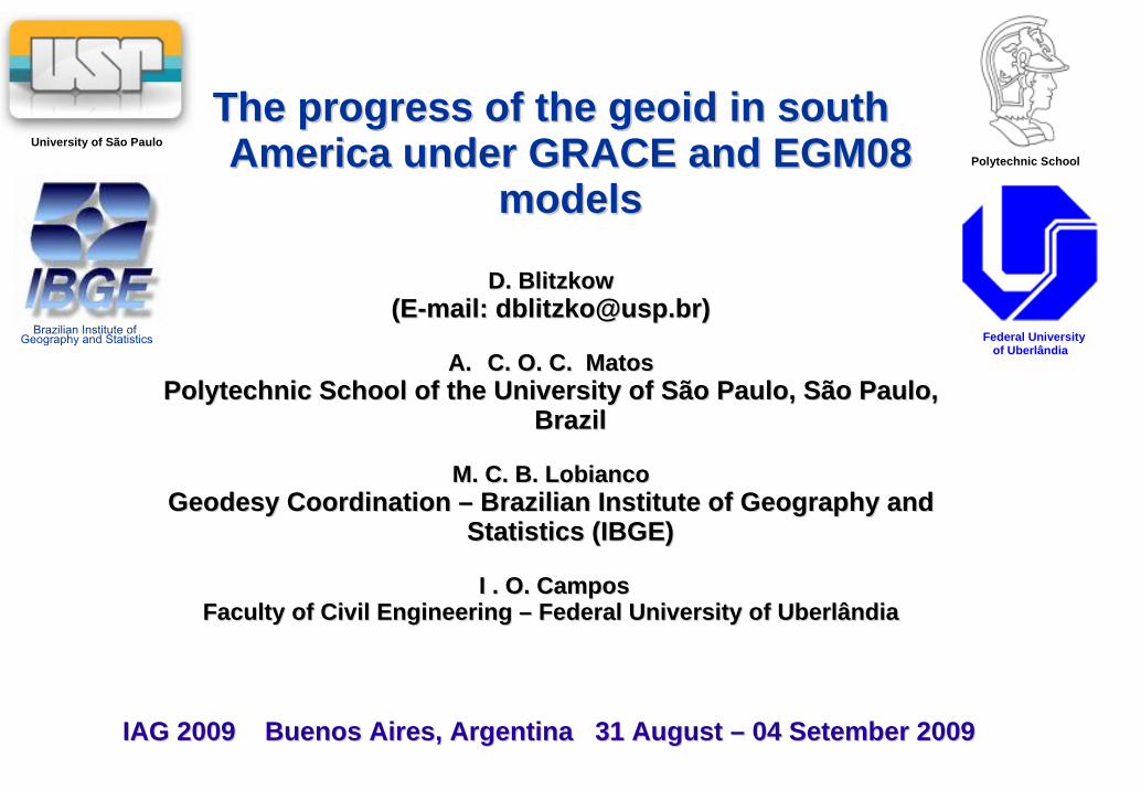
This presentation shows the particular efforts for the establishment: Geoid (quasi-geoid) model in South America
Limited by 15º N and 57º S in latitude 95º W and 30º W in longitude
The software package SHGEO developed by the University of New Brunswick-Canada Ellmann, 2005a;2005b) was used for the partial calculation combined with modified Stokes integral proposed by Featherstone et al. (1998) using FFT
The Stokes-Helmert scheme for geoid determination is:
Formulation of the boundary value problem on the Earth's surface;Evaluation of the Helmert gravity anomalies on the Earth's surface;Modified Stokes´s integration (solution to the Stokes´s boundary value problem);Computing the quasi-geoid

DIGITAL TERRAIN MODEL
SAM3s_v2 with a grid size of 3” x 3”(~90m x 90m) was used. This model consists of SRTM3 (Farr et al., 2007), but EGM96 (Lemoine et al., 1998) geiodal heights used in the SRTM3 was substituted by EIGEN-GL04C (Förste et al., 2006); in order to derive the orthometric height.. The gaps were filled by digitising maps and DTM2002 (Saleh and Pavlis, 2002, Blitzkow et al., 2007). The SHGEO package also needs:
Mean heights with resolution of 30” x 30”, 5’ x 5’. These models were derived from direct averaging of SAM3s_v1.
Global mean height 60’ x 60’: derived from ETOPO5 (1988).
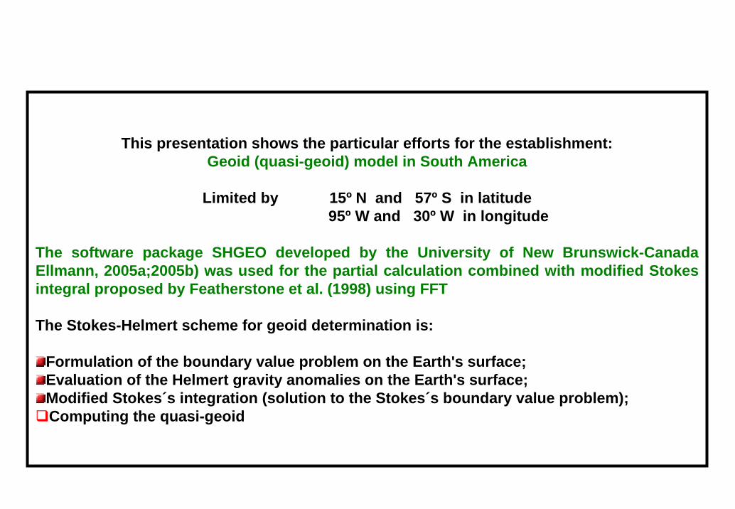
GRAVITY DATA
Many activities going on by different organizations, universities
and research institutes.
It is important to mention:● IBGE●NGA ●GETECH ●the many civil and military institutions in several countries of South America.
Due to the big efforts undertaken by the different organizations in the
last few years to improve the gravity data coverage all over the
countries there are available at the moment approximately
924,600 point gravity data in the continent, including Central
America.
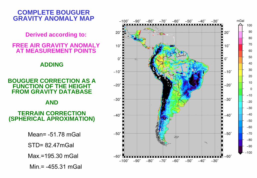
ADDING
BOUGUER CORRECTION AS A FUNCTION OF THE HEIGHT FROM GRAVITY DATABASE
AND
TERRAIN CORRECTION (SPHERICAL APROXIMATION)
Derived according to:
FREE AIR GRAVITY ANOMALYAT MEASUREMENT POINTS
COMPLETE BOUGUER GRAVITY ANOMALY MAP
Mean= -51.78 mGal
STD= 82.47mGal
Max.=195.30 mGal
Min.= -455.31 mGal
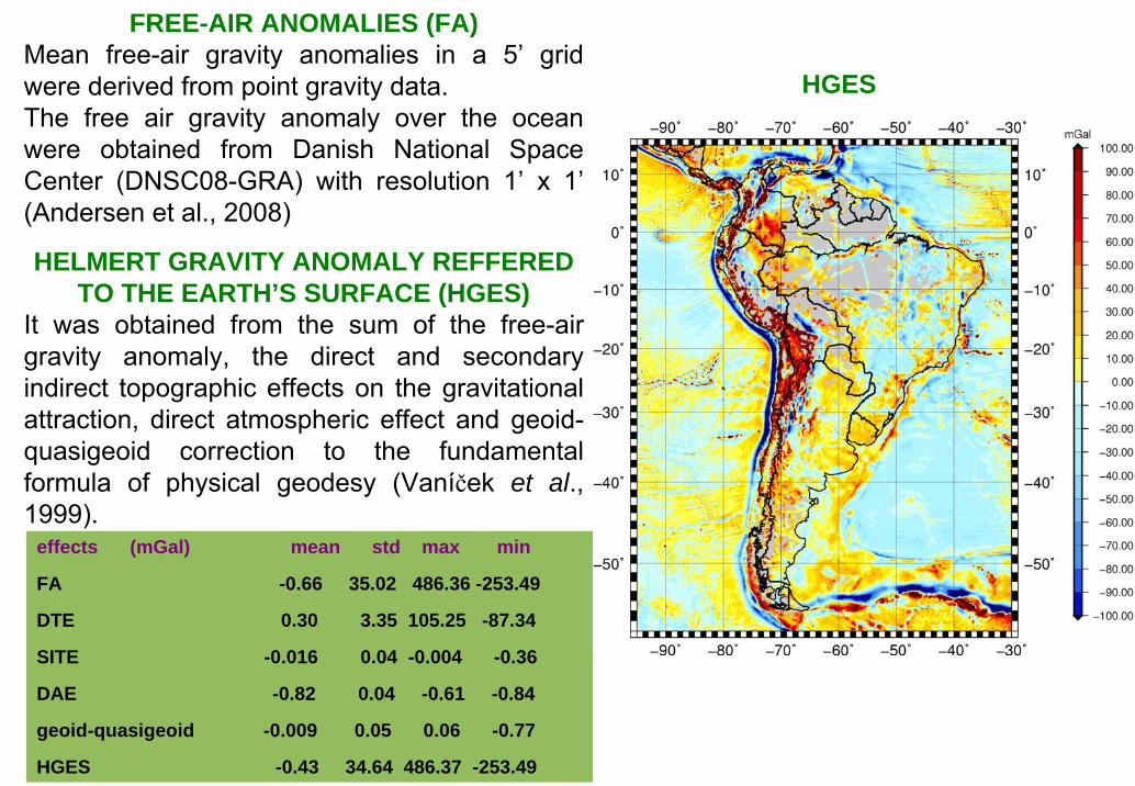
FREE-AIR ANOMALIES (FA)Mean free-air gravity anomalies in a 5’ grid were derived from point gravity data. The free air gravity anomaly over the ocean were obtained from Danish National Space Center (DNSC08-GRA) with resolution 1’ x 1’(Andersen et al., 2008)
HELMERT GRAVITY ANOMALY REFFERED TO THE EARTH’S SURFACE (HGES)
It was obtained from the sum of the free-air gravity anomaly, the direct and secondary indirect topographic effects on the gravitational attraction, direct atmospheric effect and geoid-quasigeoid correction to the fundamental formula of physical geodesy (Vaníček et al., 1999).
effects (mGal) mean std max min
FA -0.66 35.02 486.36 -253.49
DTE 0.30 3.35 105.25 -87.34
SITE -0.016 0.04 -0.004 -0.36
DAE -0.82 0.04 -0.61 -0.84
geoid-quasigeoid -0.009 0.05 0.06 -0.77
HGES -0.43 34.64 486.37 -253.49
HGES
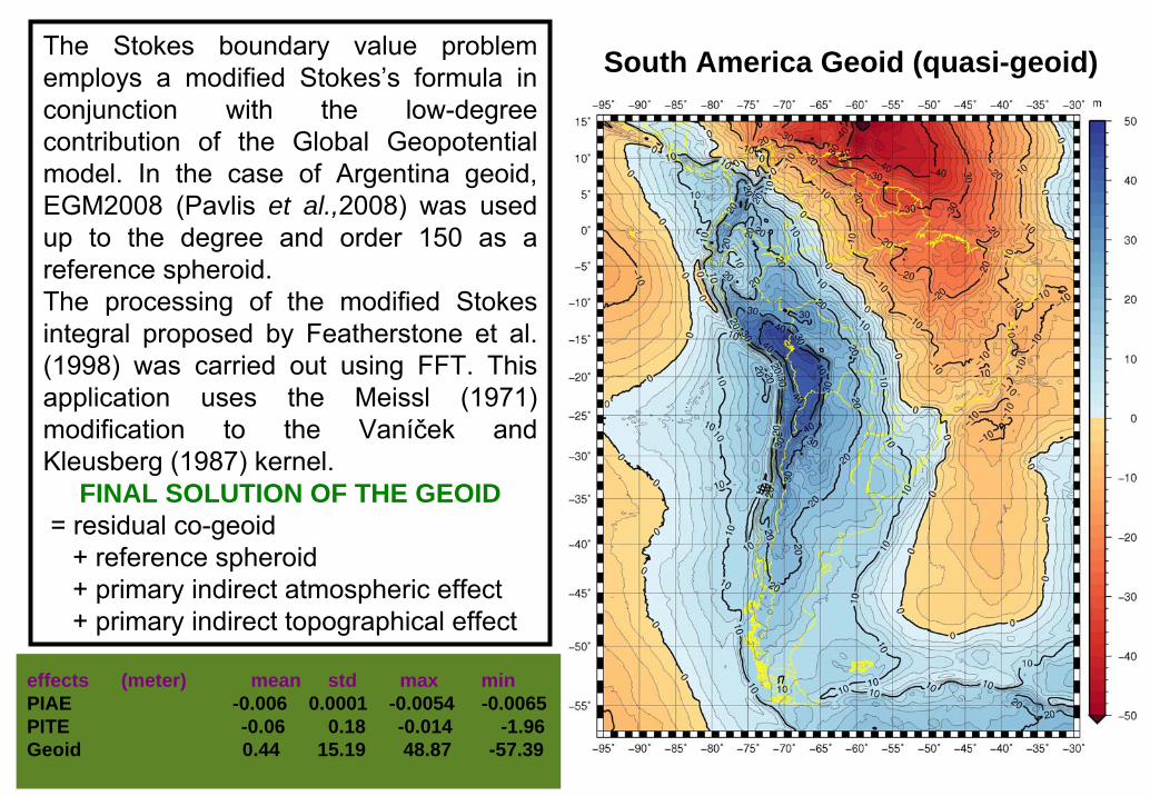
The Stokes boundary value problem employs a modified Stokes’s formula in conjunction with the low-degree contribution of the Global Geopotential model. In the case of Argentina geoid, EGM2008 (Pavlis et al.,2008) was used up to the degree and order 150 as a reference spheroid.The processing of the modified Stokes integral proposed by Featherstone et al. (1998) was carried out using FFT. This application uses the Meissl (1971) modification to the Vaníček and Kleusberg (1987) kernel.
FINAL SOLUTION OF THE GEOID= residual co-geoid
+ reference spheroid+ primary indirect atmospheric effect+ primary indirect topographical effect
South America Geoid (quasi-geoid)
effects (meter) mean std max min PIAE -0.006 0.0001 -0.0054 -0.0065 PITE -0.06 0.18 -0.014 -1.96Geoid 0.44 15.19 48.87 -57.39
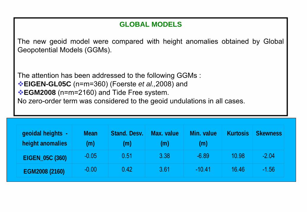
GLOBAL MODELS
The new geoid model were compared with height anomalies obtained by Global Geopotential Models (GGMs).
The attention has been addressed to the following GGMs :EIGEN-GL05C (n=m=360) (Foerste et al.,2008) and EGM2008 (n=m=2160) and Tide Free system.
No zero-order term was considered to the geoid undulations in all cases.
geoidal heights -height anomalies
Mean(m)
Stand. Desv.(m)
Max. value(m)
Min. value(m)
Kurtosis Skewness
EIGEN_05C (360) -0.05 0.51 3.38 -6.89 10.98 -2.04
EGM2008 (2160) -0.00 0.42 3.61 -10.41 16.46 -1.56
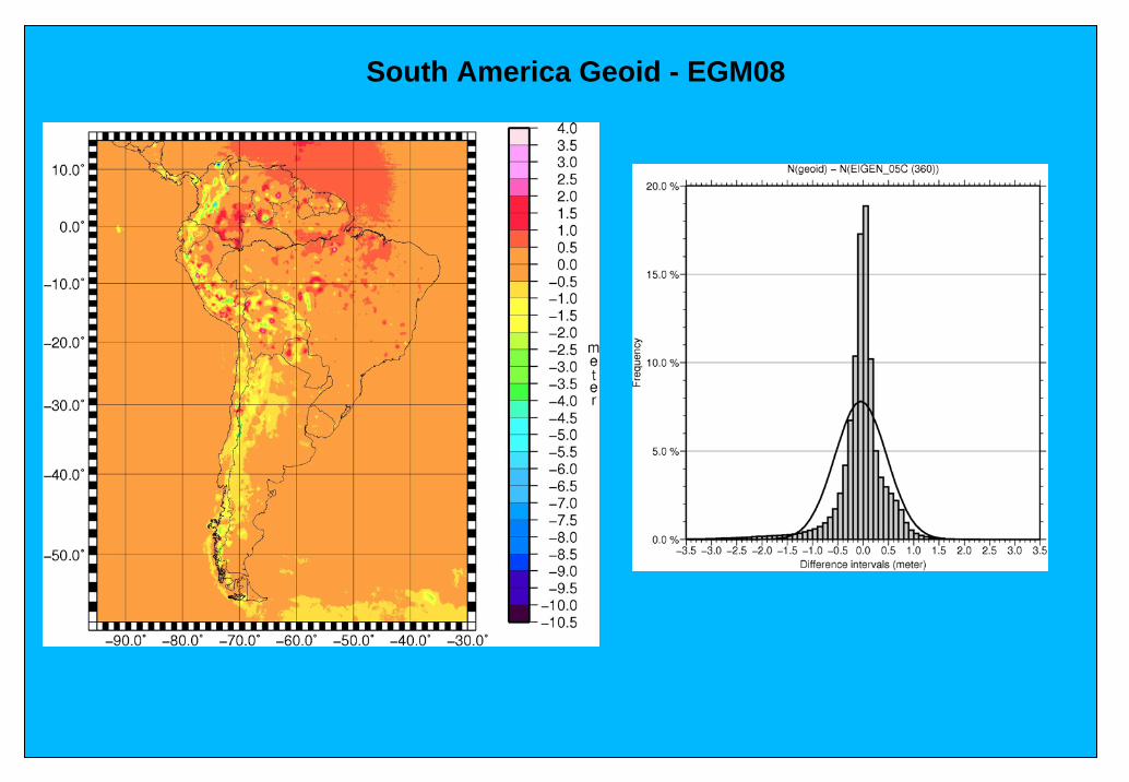
South America Geoid - EGM08
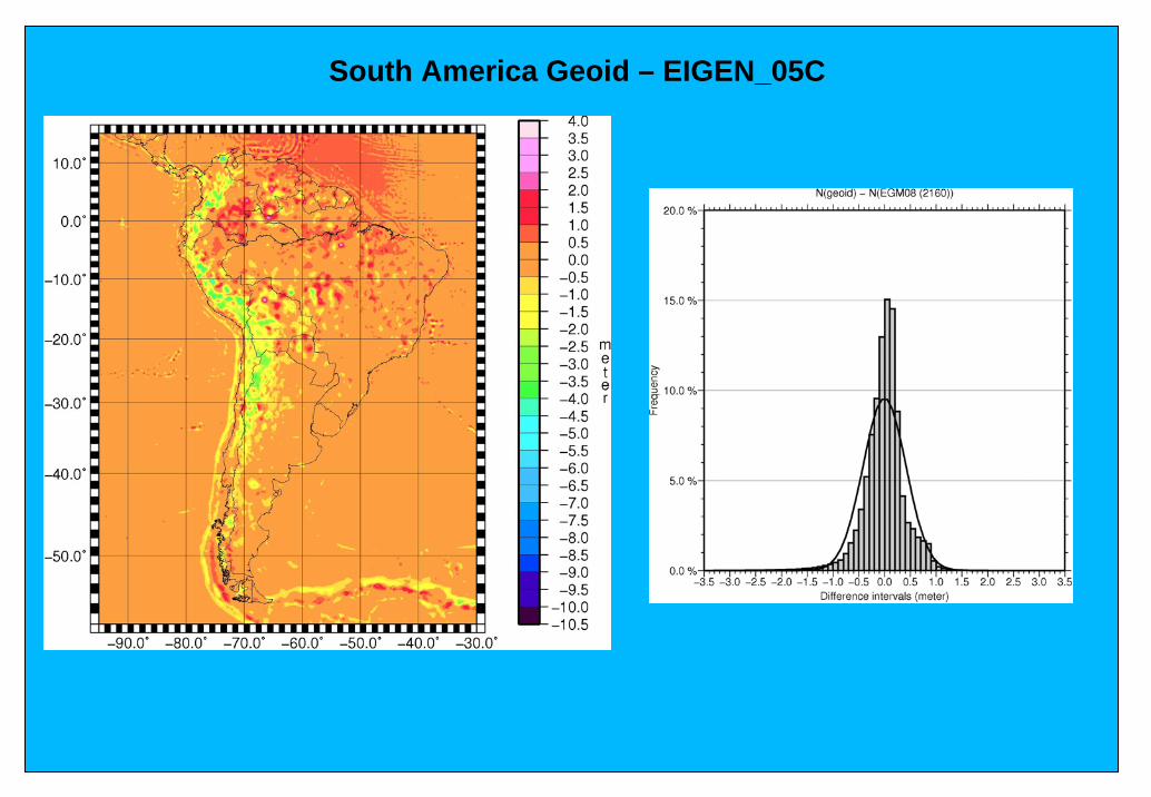
South America Geoid – EIGEN_05C
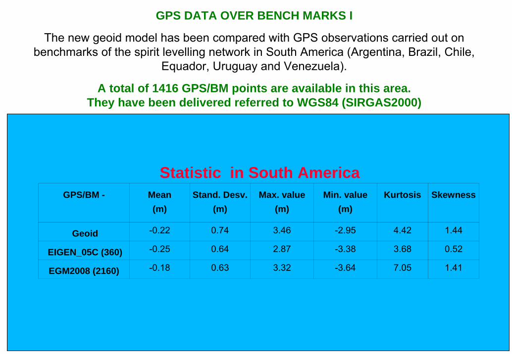
GPS DATA OVER BENCH MARKS I
The new geoid model has been compared with GPS observations carried out on benchmarks of the spirit levelling network in South America (Argentina, Brazil, Chile,
Equador, Uruguay and Venezuela).
A total of 1416 GPS/BM points are available in this area.They have been delivered referred to WGS84 (SIRGAS2000)
GPS/BM - Mean (m)
Stand. Desv.(m)
Max. value (m)
Min. value (m)
Kurtosis
Skewness
Geoid -0.22 0.74 3.46 -2.95 4.42 1.44
EIGEN_05C (360) -0.25 0.64 2.87 -3.38 3.68 0.52
EGM2008 (2160) -0.18 0.63 3.32 -3.64 7.05 1.41
Statistic in South America
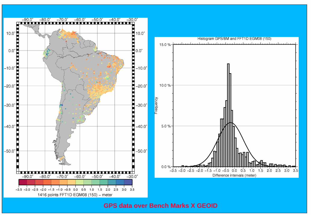
GPS data over Bench Marks X GEOID
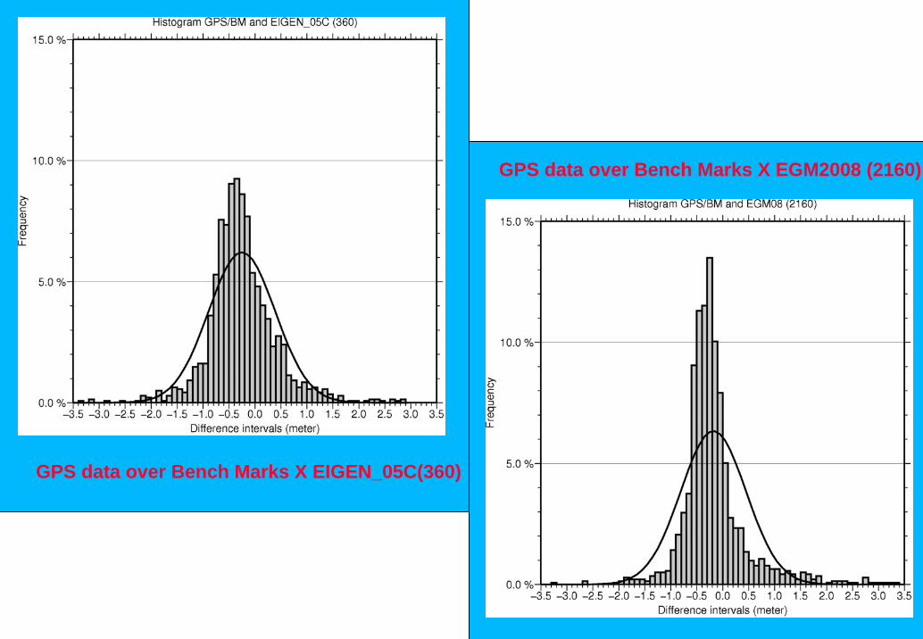
GPS data over Bench Marks X EIGEN_05C(360)
GPS data over Bench Marks X EGM2008 (2160)
GPS/BM - Mean (m)
Stand. Desv.(m)
Max. value (m)
Min. value (m)
Kurtosis
Skewness
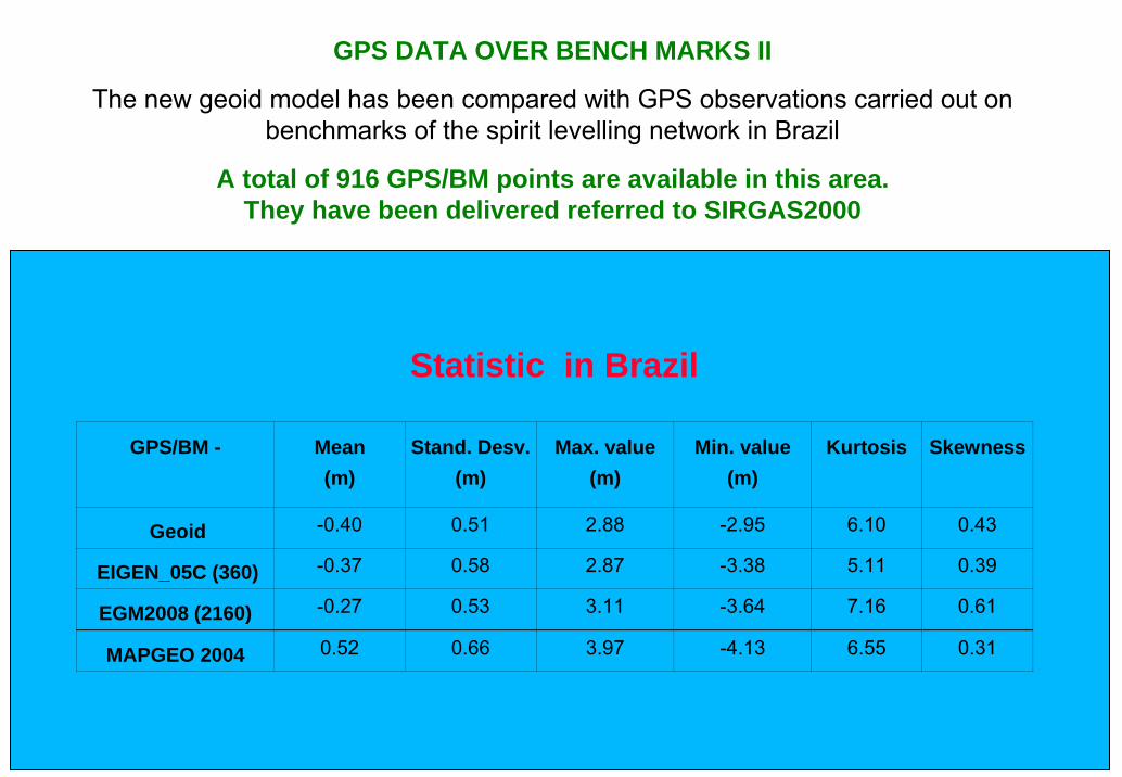
Geoid -0.40 0.51 2.88 -2.95 6.10 0.43
EIGEN_05C (360) -0.37 0.58 2.87 -3.38 5.11 0.39
EGM2008 (2160) -0.27 0.53 3.11 -3.64 7.16 0.61
MAPGEO 2004 0.52 0.66 3.97 -4.13 6.55 0.31
Statistic in Brazil
GPS DATA OVER BENCH MARKS II
The new geoid model has been compared with GPS observations carried out on benchmarks of the spirit levelling network in Brazil
A total of 916 GPS/BM points are available in this area.They have been delivered referred to SIRGAS2000
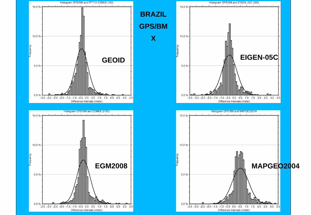
BRAZILGPS/BM
X
GEOID EIGEN-05C
EGM2008 MAPGEO2004
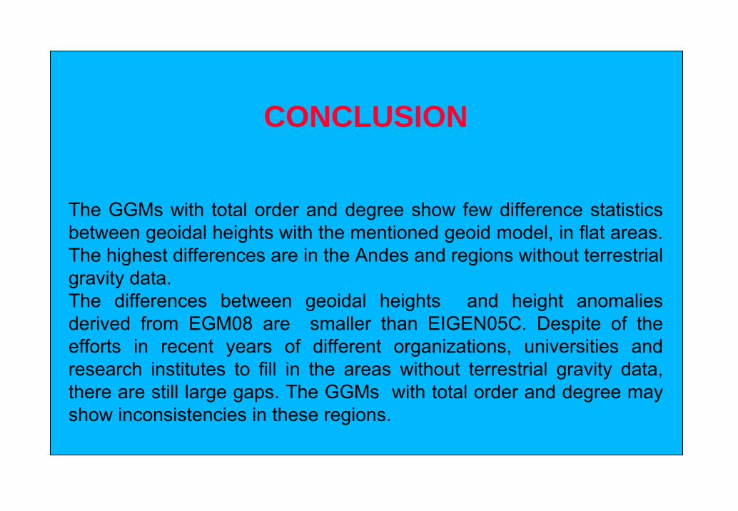
CONCLUSION
The GGMs with total order and degree show few difference statistics between geoidal heights with the mentioned geoid model, in flat areas. The highest differences are in the Andes and regions without terrestrial gravity data.The differences between geoidal heights and height anomalies derived from EGM08 are smaller than EIGEN05C. Despite of the efforts in recent years of different organizations, universities and research institutes to fill in the areas without terrestrial gravity data, there are still large gaps. The GGMs with total order and degree may show inconsistencies in these regions.
References•Andersen et al., The DNSC08 ocean wide altimetry derived gravity field. Presented EGU-2008, Vienna, Austria, April, 2008•Blitzkow, D.; A.C.O.C Matos, I.O. Campos, A. Ellmann, P. Vaníček, M.C. Santos, M.C. (2007) An attempt for an Amazon geoid model using Helmert gravity anomaly. Earth: our changing planet,, IAG General Assembly at IUGG XXIV 2007, Perugia Italia, July 2-13. ●Ellmann, A. (2005a). SHGEO software packages-An UNB Application to Stokes-Helmert Approach for Precise Geoid Computation, reference manual I , 36 p.●Ellmann, A. (2005b). SHGEO software packages-An UNB Application to Stokes-Helmert Approach for Precise Geoid Computation, reference manual II, 43 p.●ETOPO5 (1988). Data Announcement 88-MGG-02, Digital relief of the Surface of the Earth. NOAA, National Geophysical Data Center, Boulder, Colorado, 1988 •Farr, T. G., P. A. Rosen, E. Caro, R. Crippen, R. Duren, S. Hensley, M. Kobrick, M. Paller, E. Rodriguez, L. Roth, D. Seal, S. Shaffer, J. Shimada, J. Umland, M. Werner, M. Oskin, D. Burbank, D. Alsdorf (2007), The Shuttle Radar Topography Mission, Reviews of Geophysics, 45, RG2004, doi:10.1029/2005RG000183.•Featherstone, W.E., M.G Sideris (1998). Modified kernels in spectral geoid determination: first results from Western Australia. In: R. Forsberg and M. Feissl and R. Dietrich (Ed.). Geodesy on the move: gravity, geoids, geodynamics, and Antarctica, Berlin: Springer-Verlag. International Association of Geodesy Symposia, vol. 119,188-193.•Foerste, C.; Flechtner, F.; Schmidt, R.; Stubenvoll, R.; Rothacher, M.; Kusche, J.; Neumayer, K.-H.; Biancale, R.; Lemoine, J.-M.; Barthelmes, F.; Bruinsma, J.; Koenig, R.; Meyer, U. (2008), EIGEN-GL05C - A new global combined high-resolution GRACE-based gravity field model of the GFZ-GRGS cooperation, General Assembly European Geosciences Union (Vienna, Austria 2008), Geophysical Research Abstracts, Vol. 10, Abstract No. EGU2008-A-06944, 2008•Meissl, P. (1971). Preparations for the numerical evaluation of second-order Molodensky-type formulas, Report 163, Department of geodetic Science and Surveying, ohio State university, Columbus, USA, 72 pp.•Pavlis, N.K, S.A. Holmes, S.C. Kenyon, J.K. Factor. An Earth Gravitational Model to Degree 2160: EGM2008- Presentation given at the 2008 European Geosciences Union General Assembly held in Vienna, Austria, April13-18, 2008. Available in :http://earth-info.nga.mil/GandG/wgs84/gravitymod/egm2008•Saleh, J., and N.K. Pavlis (2002). The development and evaluation of the global digital terrain model DTM2002, 3rd Meeting of the International Gravity and Geoid Commission, Thessaloniki, Greece.•Vaníček, P. and A. Kleusberg, (1987). The Canadian geoid-Stokesian approach. Manuscripta Geodaetica, 12(2), pp. 86-98. •Vaníček, P., J. Huang, P. Novák, S.D. Pagiatakis, M. Véronneau, Z. Martinec and W.E. Featherstone, (1999). Determination of the boundary values for the Stokes–Helmert problem, J. Geodesy 73, pp. 160–192.
Acknowledgements
The authors acknowledge Prof. Dr. Artur Ellmann (Tallinn University of Technology), Prof. Dr. Peter Vaníček and Prof Dr. Marcelo Carvalho dos Santos (University of New Brunswick), CNPq for supporting this research. The Activity has been partially undertaken with the financial support of Government of Canada provided through the Canadian International Development Agency (CIDA).
THANKS