The Malaysia Real-Time Kinematic GNSS Network (MyRTKnet) in 2010
Upload
hoangquynhCategory
view
219download
0
GNGTS 2016 sessione 1.2
205
the present itaLian kinematic pattern from gnss data N. Cenni1, M.E. Belardinelli1, P. Baldi1, F. Loddo2, S. Gandolfi3, L. Poluzzi3, L. Tavasci3, E. Mantovani4,D. Babbucci4, M. Viti4
1 Dipartimento di Fisica ed Astronomia, Università di Bologna, Italy2 Istituto Nazionale di Geofisica e Vulcanologia, Sezione di Bologna, Italy 3 Dipartimento di Ingegneria Civile, Chimica, Ambientale e dei Materiali (DICAM), Università di Bologna, Italy4 Dipartimento Scienze Fisiche, della Terra e dell’Ambiente, Università di Siena, Italy
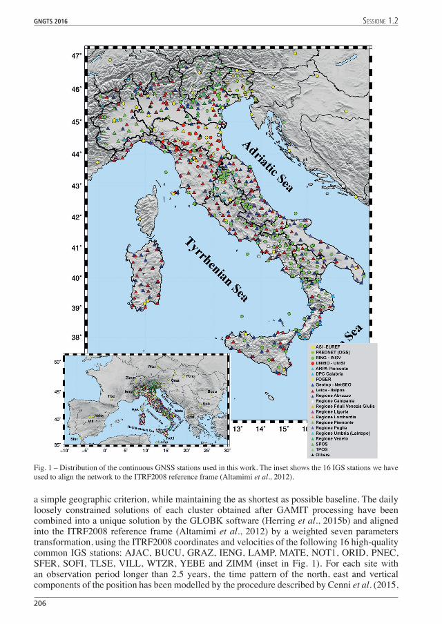
The present Italian kinematic field has been estimated by a network of about 600 GNSS permanent stations unevenly distributed on the study area (Fig. 1). The daily observationsunevenly distributed on the study area (Fig. 1). The daily observations daily observations acquired with a sampling rate of 30 seconds from January 01, 2001 to August, 1, 2016 have been analysed by GAMIT software (version 10.6, Herring et al., 2015a), adopting a distributed procedure (Dong et al., 1998). The whole network has been divided into 45 clusters, following
206
GNGTS 2016 sessione 1.2
a simple geographic criterion, while maintaining the as shortest as possible baseline. The daily loosely constrained solutions of each cluster obtained after GAMIT processing have been combined into a unique solution by the GLOBK software (Herring et al., 2015b) and aligned into the ITRF2008 reference frame (Altamimi et al., 2012) by a weighted seven parameters transformation, using the ITRF2008 coordinates and velocities of the following 16 high-quality common IGS stations: AJAC, BUCU, GRAZ, IENG, LAMP, MATE, NOT1, ORID, PNEC, SFER, SOFI, TLSE, VILL, WTZR, �EBE and ZIMM (inset in Fig. 1). For each site with an observation period longer than 2.5 years, the time pattern of the north, east and vertical components of the position has been modelled by the procedure described by Cenni et al. (2015,
Fig. 1 – Distribution of the continuous GNSS stations used in this work. The inset shows the 16 IGS stations we have used to align the network to the ITRF2008 reference frame (Altamimi et al., 2012).

GNGTS 2016 sessione 1.2
207
2013, 2012). The uncertainty associated with the velocity has been estimated by adopting the Allan Variance of the Rate method, introduced by Hackl et al. (2011) in order to take into account the correlated noise of the GPS daily position. The present horizontal kinematic field obtained at the end of time series analysis is shown in Fig. 2. It can be noted that the outer part of the Apennine belt (Adriatic margin) moves faster and with a greater eastward component, with respect to the inner belt (Tyrrhenian sector). The sites located on the Adriatic marginTyrrhenian sector). The sites located on the Adriatic margin. The sites located on the Adriatic margin are characterized by velocities with values greater than 3 mm/year mainly oriented NE-ward. Conversely, the kinematic of the stations located on the Tyrrehenian sector are characterized by relatively low velocity, with values lower than 2 mm/year, and direction oriented from NW
Fig. 2 – Horizontal kinematic pattern with respect to a fixed Eurasia, modelled using the Euler pole proposed by Altamimi et al. (2012): 54.23°N, 98.83°W, ω = 0.257°/Myr. The colours of circles indicate the velocity amplitudes following the chromatic scale on the figure.
208
GNGTS 2016 sessione 1.2
to North ward in the southern part and roughly NE-ward in the northern part. This pattern confirms the major features of the kinematics tentatively deduced by Quaternary deformations and detailed discussed in some previous works (e.g., Mantovani et al., 2011, 2012, 2013, 2015 Cenni et al., 2012, 2013).
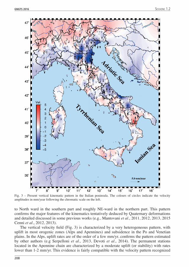
The vertical velocity field (Fig. 3) is characterized by a very heterogeneous pattern, with uplift in most orogenic zones (Alps and Apennines) and subsidence in the Po and Venetian plains. In the Alps, uplift rates are of the order of a few mm/yr, confirms the pattern estimated by other authors (e.g Serpelloni et al., 2013, Devoti et al., 2014). The permanent stations located in the Apennine chain are characterized by a moderate uplift (or stability) with rates lower than 1-2 mm/yr. This evidence is fairly compatible with the velocity pattern recognized
Fig. 3 – Present vertical kinematic pattern in the Italian peninsula. The colours of circles indicate the velocity amplitudes in mm/year following the chromatic scale on the left.
GNGTS 2016 sessione 1.2
209
by levelling campaigns performed by the Istituto Geografico Militare Italiano (I.G.M.I.) for about 130 years, along routes covering the national territory (D’Anastasio et al., 2006) and by more recent GNSS studies (e.g, Serpelloni et al., 2013; Devoti et al., 2011, 2014). The uplift of the Apennines is consistent with the effects expected from the longitudinal shortening of the belt suggested by some authors (e.g., Mantovani et al., 2009, 2015a, 2015b; Viti et al., 2015a, 2015b). The vertical kinematic pattern in the Venetian and Po plains showed in figure 3 seems to indicate that the subsidence pattern is constant or in some cases, decreasing with respect to the values obtained with different observation time spans and/or techniques (e.g. Arca and Beretta, 1985; Baldi et al., 2009, 2011; Cenni et al., 2013; Teatini et al., 2012). Moderate uplift with values lower than 2 mm/year are observed in the GNSS stations located on the Calabrian Arc and Sicily region. The Sardinia vertical pattern shows a heterogeneous vertical kinematic patter (Fig. 3) probably due to local anthropogenic processes such as groundwater pumping.
The results of these studies and in particular the principal features of the horizontal and vertical kinematic pattern, will be shown and discussed during the workshop. The first results obtained by a study concerning time variations of velocities observed in some GNSS stations and their possible correlations with tectonic processes, natural phenomena or anthropogenic activities.
Acknowledgments. We are grateful to the following Institutions: ASI, ARPA Piemonte, FOGER (Fondazione dei Geometri e Geometri Laureati dell’Emilia Romagna), FREDNET – OGS, LEICA – Italpos, NETGeo – Topocon, Regione Abruzzo, Regione Friuli Venezia Giulia, Regione Lazio, Regione Liguria, Regione Piemonte, Regione Umbria – Labtopo (University of Perugia), Regione Veneto, RING-INGV, Provincia Autonoma di Bolzano (STPOS), Provincia Autonoma di Trento (TPOS), STONEX, which have kindly made available GPS recordings. The FiguresThe Figures have been carried out by the Generic Mapping Tools (Wessel et al., 2013).
References Arca S. and Beretta G.P.; 1985: Prima sintesi geodetica-geologica sui movimenti verticali del suolo nell’Italia
Settentrionale. Boll. Geod. Sci. Aff., 44, 125-156.Altamimi, Z., Métivier, L. and Collilieux, X.; 2012: ITRF2008 Plate Motion Model. Journal of Geophysical Research,
117, Article ID: B07402. http://dx.doi.org/10.1029/2011JB008930.Baldi P., Casula G., Cenni N., Loddo F. and Pesci, A.; 2009: GPS-based monitoring of land subsidence in the Po Plain
(Northern Italy). Earth Planet. Science Letts., 288, 204-212, doi:10.1016/j.epsl.2009.09.023.Baldi, P., Casula, G., Cenni, N., Loddo, F., Pesci, A., Bacchetti, M.; 2011: Vertical ad horizontal crustal movements in
Central and Northern Italy. Boll.Soc.Geol.It. (Ital. J. Geosci.), 52, 4, 667-685. Cenni N., Mantovani E., Baldi P. and Viti M.; 2012: Present kinematics of Central and Northern Italy from continuous
GPS measurements. J. Geodyn., 58, 62-72.Cenni, N., Viti, M., Baldi, P., Mantovani, E., Bacchetti, M.,Vannucchi, A.; 2013: Present vertical movements in central
and northern Italy from GPS data: possible role of natural and anthropogenic causes. Journal of Geodynamics,Journal of Geodynamics, 71, 74-85. doi: 10.1016/j.jog.2013.07.004.
Cenni, N., Baldi P., Belardinelli, M.E., Gandolfi, S., Loddo, F., Mantovani E., Viti M.; 2015: The GPS vertical kinematic pattern In the Italian peninsula: characteristics and anthropogenic geodynamic implications. Atti del 34° Convegno Nazionale del Gruppo Nazionale di Geofisica della Terra Solida, 2015. 1, 96-102.
D’Anastasio, E., De Martini, P.M., Selvaggi, G., Pantosti, D., Marchioni, A., Maseroli, R.; 2006: Short-term vertical velocity field in the Apennines (Italy) revealed by geodetic levelling data. Tectonophysics, 418, 219–234.
Devoti, R., Esposito, A., Pietrantonio, G., Pisani A.R., Riguzzi, F., Evidence of large scale deformation patterns from GPS data in the Italian subduction boundary; 2011, Earth and Planetary Science Letters, 311, 230–241
Devoti R., Pietrantonio G., Riguzzi F. (2014). GNSS networks for geodynamics in Italy. Física de la Tierra, Vol. 26,GNSS networks for geodynamics in Italy. Física de la Tierra, Vol. 26, 11-24.
Dong D., Herring T.A. and King R.W.; 1998: Estimating regional deformation from a combination of space and terrestrial geodetic data. J. Geod., 72, 200-214.i
Hackl M., Malservisi R., Hugentobler U. and Wonnacott R., 2011: Estimation of velocity uncertainties from GPS time series: Examples from the analysis of the South African TrigNet network. J. Geophys. Res., 116, B11404, doi:10.1029/2010JB008142.
Herring T.A., King R.W., Floyd M.A. and McClusky S.C.; 2015a: GAMIT Reference Manual, GPS Analysis at MIT, Release 10.6. Department of Earth, Atmospheric and Planetary Sciences, Massachusset Institute of Technology, Cambridge MA.

210
GNGTS 2016 sessione 1.2
Herring T.A., Floyd M.A., King R.W and McClusky S.C.; 2015b: Global Kalman filter VLBI and GPS analysis program, GLOBK Reference Manual, Release 10.6. Department of Earth, Atmospheric and Planetary Sciences, Massachusset Institute of Technology, Cambridge MA.
Mantovani E., Viti M., Babbucci D. and Tamburelli C; 2009: A review on the driving mechanism of the Tyrrhenian-Apennines system: implications for the present seismotectonic setting in the Central-Northern Apennines. Tectonophysics, 476, 22-40.
Mantovani, E., Viti, M., Babbucci, D., Tamburelli, C., Cenni, N., Baglione, M. and D’Intinosante, V.; 2015a: Present Tectonic Setting and Spatio-Temporal Distribution of Seismicity in the Apennine Belt. International Journal of Geosciences, 6, 429-454. http://dx.doi.org/10.4236/ijg.2015.64034 .
Mantovani, E., Viti, M., Cenni, N., Babbucci, D., Tamburelli, C., Baglione, M. and D’Intinosante, V.; 2015b: Seismotectonics and Present Seismic Hazard in the Tuscany-Romagna-Marche-Umbria Apennines (Italy). Journal of Geodynamics, 89, 1-14. doi: 10.1016/j.jog.2015.05.001.
Serpelloni, E., C. Faccenna, G. Spada, D. Dong, and S. D. P. Williams (2013), Vertical GPS ground motion rates in the Euro-Mediterranean region: New evidence of velocity gradients at different spatial scales along the Nubia-Eurasia plate boundary, J. Geophys. Res. Solid Earth, 118, doi:10.1002/2013JB010102.
Teatini, P., Tosi, L., Strozzi, T., Carbognin, L., Cecconi, G., Rosselli, R., Libardo, S.; 2012: Resolving land subsidence within the Venice Lagoon by persistent scatterer SAR interferometry. Phys. Chem. Earth, 40/41, 72–77.
Viti, M., Mantovani, E., Babbucci, D., Tamburelli, C., Cenni, N., Baglione, M. and D’Intinosante, V.; 2015a: Belt-Parallel Shortening in the Northern Apennines and Seismotectonic Implications. International Journal of Geosciences, 6, 938-961. doi: 10.4236/ijg.2015.68075
Viti, M., Mantovani, E., Babbucci, D., Cenni, N. and Tamburelli, C.; 2015b: Where the Next Strong Earthquake in the Italian Peninsula? Insights by a Deterministic ApproachInsights by a Deterministic Approach. Bollettino di Geofisica Teorica ed Applicata, 56, 2, 329-350.
Wessel, P., Smith, W.H.F., Scharroo, R., Luis, J.F., and Wobbe, F.; 2013: Generic Mapping Tools: Improved version released, EOS Trans. AGU,AGU, 94, 409-410.


![Improving the Performance of Multi-GNSS (Global …...and monitoring system via mobile platforms, for example, for airborne gravimetry [1]. Usually, the traditional relative kinematic](https://static.fdocuments.us/doc/165x107/5f3dfe61d3768a5f252c4dd1/improving-the-performance-of-multi-gnss-global-and-monitoring-system-via-mobile.jpg)