
The potential to store flood flow in the rural landscape ... Potential to... · flood flow in the...
17
The potential to store flood flow in the rural landscape upstream of Brunton Bridge on the River Ouseburn A Feasibility Study Dr Paul Quinn, Dr Mark Wilkinson and Dr Jennine Jonczyk Civil Engineering and Geosciences Newcastle University
-
Upload
truongcong -
Category
Documents
-
view
219 -
download
1
Transcript of The potential to store flood flow in the rural landscape ... Potential to... · flood flow in the...
The potential to store flood flow in the rural
landscape upstream of Brunton Bridge on the
River Ouseburn
A Feasibility Study
Dr Paul Quinn, Dr Mark Wilkinson and Dr Jennine Jonczyk
Civil Engineering and Geosciences
Newcastle University

Executive Summary
Newcastle University are in the process of monitoring water level and quality in the River Ouseburn and have been closely involved in the stakeholder engagement with the local population, gaining unrivalled local knowledge of the Upper Ouseburn landscape. This dynamic characterisation approach has allowed the assessment of the potential to reduce flood flow from the rural area in the Ouseburn. This approach has been used successfully, for example, in flood risk management projects in collaboration with the EA flood levy team, at Belford and in supporting the Powburn and Hepscott flood risk management projects. Key conclusions:
There is great potential to reduce runoff volumes and especially the speed of runoff from the Upper Ouseburn area.
The soft engineering techniques explored in the Belford project are very applicable to the Upper Ouseburn.
There is a need for multi-scale approach to the nature of the interventions that will require many small interventions in the upper part of the catchment and a smaller number of larger „opportunistic‟ flood storage features.
Initial stakeholder engagement has already given the possibility to design and construct several features in the near future.
4 examples of intervention will be outlined and initial designs will be put forward
The cost of the 4 interventions should not exceed £100,000-150,000. A one-off payment or reimbursement scheme for some farmers may be necessary.

Contents
Aims and objectives of feasibility study Area of study Flood levels in the Upper Ouseburn The scale dependent design of features The Belford Approach and Evidence Possible locations for intervention in the Ouseburn
Callerton ‘nature reserve’ o supporting information o pro-forma 1 for EA
Callerton Village o supporting information o pro-forma 2 for EA
Callerton pond expansion o supporting information o pro-forma 3 for EA .
Brunton Farm flood plain storage zone o supporting information o pro-forma 4a and 4b for EA .
Black Callerton ponds o supporting information o pro-forma 5 for EA .
Conclusions Appendix 1 RAF Ouseburn handbook Appendix 2 RAF Belford handbook

Aims and objectives of feasibility study The main aims of this feasibility study are to investigate options at 3 sites to manage flood risk from rural sources on the Ouseburn. The report will list 4 sites where construction is possible in the short term. We will also highlight several other sites that we have located through field work and terrain analysis as excellent sites for „cheap‟ runoff storage. The monitoring component of the Ouseburn collaborative partnership is focussed on the stretch between Brunton Bridge and Three Mile Bridge and is an on-going task. Data from this monitoring reflects the need to lower flood levels arising from the rural area and that high river level are a major cause of sewer outfalls being drowned out exacerbating the flooding lower in the Ouseburn (Wilkinson & Quinn , 2008). Studies in and around the new Sustainable Drainage Systems at The Newcastle Great Park Development has also encouraged many stakeholders that direct intervention to storing and slowing runoff is possible. This „landscape‟ scale approach is cheaper than traditional flood defence measures and works in tandem with nature rather than against it. Moreover a more „holistic‟ approach to the management of flooding is arising and this feasibly study reflects the positive trend towards a catchment-scale flood solutions. Along with the solid evidence arising from the Belford Project, it is now possible to propose a new tranche of runoff attenuation features for the Ouseburn.
This feasibility study will focus on the following deliverables agreed in the collaborative agreement
To draw up a feasibility study report for the types of flood alleviation schemes that could operate in the Upper Ouseburn. A generic review of the possible impact of rural/suburban intervention in the Upper Ouseburn
Three trial sites will be studied in detail: Callerton Ponds, Woolsington Woods and the area upstream of Brunton Farm
To recognise the Environment Agency Local Levy funding of the projects in all communications associated with the monitoring.
To work with the Environment Agency to communicate the findings and to broaden the uptake of this approach.
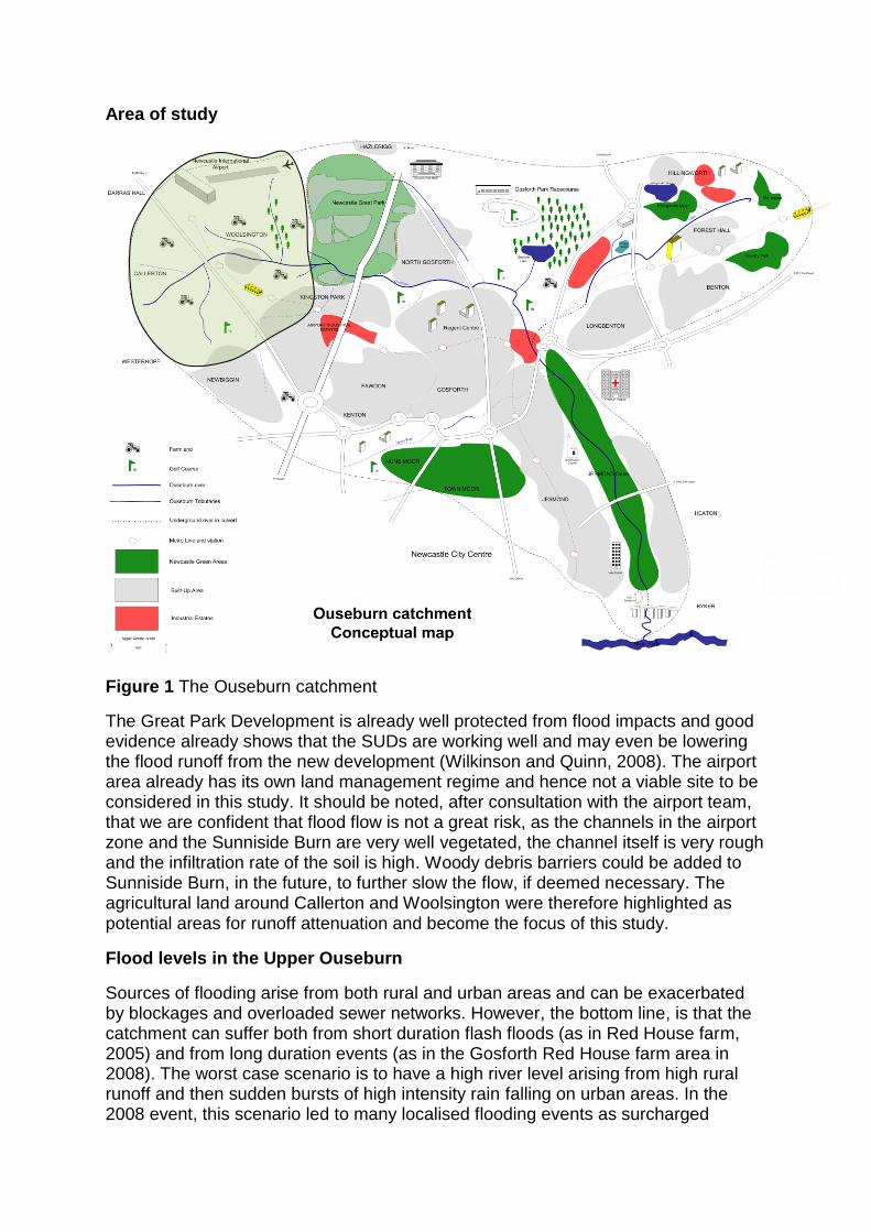
Area of study
Figure 1 The Ouseburn catchment
The Great Park Development is already well protected from flood impacts and good evidence already shows that the SUDs are working well and may even be lowering the flood runoff from the new development (Wilkinson and Quinn, 2008). The airport area already has its own land management regime and hence not a viable site to be considered in this study. It should be noted, after consultation with the airport team, that we are confident that flood flow is not a great risk, as the channels in the airport zone and the Sunniside Burn are very well vegetated, the channel itself is very rough and the infiltration rate of the soil is high. Woody debris barriers could be added to Sunniside Burn, in the future, to further slow the flow, if deemed necessary. The agricultural land around Callerton and Woolsington were therefore highlighted as potential areas for runoff attenuation and become the focus of this study.
Flood levels in the Upper Ouseburn
Sources of flooding arise from both rural and urban areas and can be exacerbated by blockages and overloaded sewer networks. However, the bottom line, is that the catchment can suffer both from short duration flash floods (as in Red House farm, 2005) and from long duration events (as in the Gosforth Red House farm area in 2008). The worst case scenario is to have a high river level arising from high rural runoff and then sudden bursts of high intensity rain falling on urban areas. In the 2008 event, this scenario led to many localised flooding events as surcharged
sewers could not drain to the Ouseburn. Future climate change scenarios suggest we may be looking at a future where storm events are more frequent and more intense (UKCP09 scenarios and Hickey 2008). In all cases, there is a clear need to reduce the water level in the Ouseburn. The only „non traditional‟, cost effective ways to achieve this is to store and attenuate flood flows upstream. However the evidence base to support this approach is only now arising from Local Flood Levy projects in Belford and in Powburn and Hepscott projects.
Newcastle University has worked with the EA and Defra at national level, looking at the risk of flooding arising from farms (see FD2010 reports (DEFRA and EA, 2004) and O'Connell et al , 2007) and established clear evidence that intense farming gives rise to rapid runoff. Farmland is often well connected to the channel especially with land drains which are common in the upper Ouseburn. Soil degradation causes a loss of intrinsic water storage capacity and on occasion large rainstorms falling on ploughed field can give rise to „muddy floods.‟
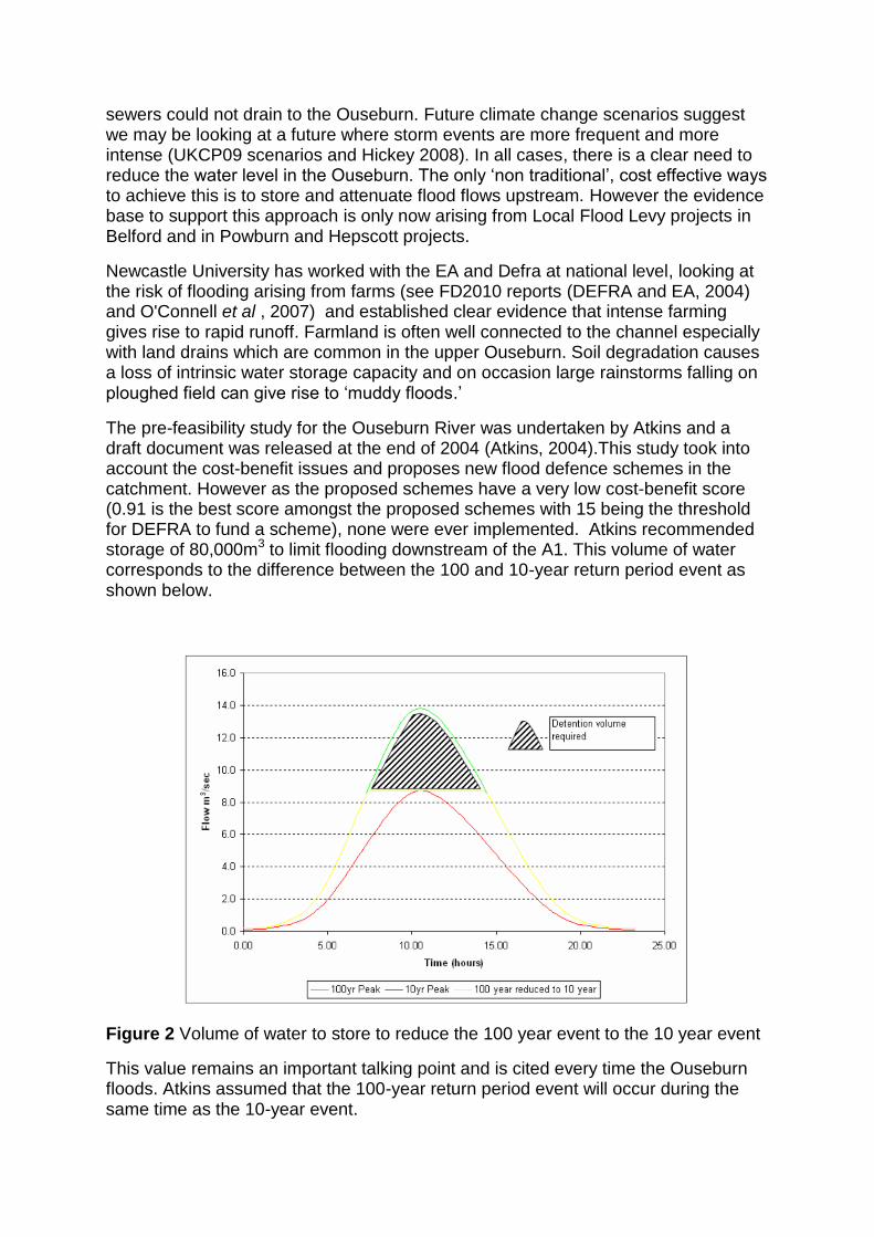
The pre-feasibility study for the Ouseburn River was undertaken by Atkins and a draft document was released at the end of 2004 (Atkins, 2004).This study took into account the cost-benefit issues and proposes new flood defence schemes in the catchment. However as the proposed schemes have a very low cost-benefit score (0.91 is the best score amongst the proposed schemes with 15 being the threshold for DEFRA to fund a scheme), none were ever implemented. Atkins recommended storage of 80,000m3 to limit flooding downstream of the A1. This volume of water corresponds to the difference between the 100 and 10-year return period event as shown below.
Figure 2 Volume of water to store to reduce the 100 year event to the 10 year event
This value remains an important talking point and is cited every time the Ouseburn floods. Atkins assumed that the 100-year return period event will occur during the same time as the 10-year event.

This finding is very useful as it scopes out the volume of water required to protect Gosforth. It also reflects the traditional scoring approach to funding projects. The Belford Project had similar problems, in that a traditional approach was difficult to
justify. The primary finding from Belford is that it is difficult to get a very large amount of flood storage volume, but it is possible to attenuate flows and affect the shape of the hydrographs. Whilst the proposed runoff attenuation features proposed here do store substantial flow, it is the ability to slow flow that could be greatly beneficial to
the Ouseburn. The typical response of the Ouseburn can be seen in figures 3 and 4.
Figure 3 A comparisons of the rural and urban flow components, typical of the Upper Ouseburn (Wilkinson et al 2008).
Figure 4 A long duration storm without an urban spike (Wilkinson et al 2008).
0.0
1.0
2.0
3.0
4.0
5.0
6.0
21/01/
2008 0
6:00
21/01/
2008 0
9:15
21/01/
2008 1
2:30
21/01/
2008 1
5:45
21/01/
2008 1
9:00
21/01/
2008 2
2:15
22/01/
2008 0
1:30
22/01/
2008 0
4:45
22/01/
2008 0
8:00
22/01/
2008 1
1:15
22/01/
2008 1
4:30
22/01/
2008 1
7:45
22/01/
2008 2
1:00
Dis
cha
rge
(m
3/s
)
Brunton Bridge Kingston Park Red House Three Mile
Flashy urban flow peaks
Rural flow component is
very significant

In both cases, the flow rate is high, but typically the urban spike occurs first but this may not always be the case. Even in figure 4, the time to peak and the shaped of the hydrograph are quite „spiky‟. There is thus an opportunity lower the flow in the Upper Ouseburn, to slow the flow down and change the shape of the rural response.
One way of justifying the potential to do this now is to look at the impact that the Melbury SUDs (cell I) has on flood flow (figure 5). If flow can be stored and slowed, then large components of the hydrograph could be altered. The size of the features proposed in the Upper Ouseburn are much smaller than cell I, however, the aggregate effect of many small features will be the same.
Figure 5 Time series showing CELL I SUD working to store flood flow and build-up storage before then releasing the flow back to the channel when the main peak has passed.
0
1
2
3
4
5
6
21/0
1/2
008 0
0:0
021/0
1/2
008 0
7:3
021/0
1/2
008 1
5:0
021/0
1/2
008 2
2:3
022/0
1/2
008 0
6:0
022/0
1/2
008 1
3:3
022/0
1/2
008 2
1:0
023/0
1/2
008 0
4:3
023/0
1/2
008 1
2:0
023/0
1/2
008 1
9:3
024/0
1/2
008 0
3:0
024/0
1/2
008 1
0:3
024/0
1/2
008 1
8:0
025/0
1/2
008 0
1:3
025/0
1/2
008 0
9:0
025/0
1/2
008 1
6:3
026/0
1/2
008 0
0:0
0
Flo
w (
m3/s
) -
Red H
ouse
0
0.05
0.1
0.15
0.2
0.25
0.3
0.35
0.4
0.45
0.5
SU
D w
ate
r le
vel (m
)
Red house SUD

The scale-dependent design of features
Figure 6 Scale-dependent locations for features
The size, type and function of the proposed features relates closely to the catchment hydrology of the area. The main channel does not generate significant amounts of runoff, though it does convey all the flow. The small channels and ditches are giving rise to 60-70% of the runoff. This means that smaller features close to where the runoff is generated can be targeted. So runoff attenuation features (RAFs) like ponds
60 – 70% of the catchment drains small channels
20% of the catchment drains medium channels
Floodplain
10 Interventions
2-3 opportunistic larger scale features
1-2 flood plain storage zones
Three levels of Intervention
Small scale intervention on small channels
requires many features

and the manipulation of the ditches and small channels themselves may be possible. In an area like the upper Ouseburn, approximately 10 runoff attenuation features may be needed.
Larger channels will gather more runoff and convey the flow; however, the channel may still be small enough to afford a relatively cheap intervention, either a woody debris dam or small diversion to take the peak flow out of the channel into temporary storage. In the Ouseburn there is a mixture of several storage zones that could be exploited on slightly larger channels.
Finally, the main channel itself may have a larger flood plain. The goal is thus to find a location where flow can be diverted from the main channel and significant temporary flood storage be created. However care is needed to make sure that the floodplain intrinsic storage capacity is not removed. Also any other local features on the flood plain (such as farm buildings) are not put at risk. This type of feature may be beyond the scope of this feasibility study and may need a more detailed study. We will highlight a zone where significant flood flow is possible and the local farmers are willing to work with the EA.
The Belford approach
The Runoff Attenuation Feature handbook is the main deliverable from the Belford project, (Appendix 2) and a version for the Ouseburn can be seen in Appendix 1. More evidence arising from Belford is now being published (Wilkinson et al., 2008 and Wilkinson et al., 2010)
The RAF handbook shows the reader that features can be built, for very little cost and that permission can be gained and that the soft engineering approach is viable.
Table 1 Travel time of flood peak before and after construction of the pilot RAF
(taken from Wilkinson et al., 2010)

Figure 7 Pilot RAF (Pond 0) and stream (downstream of diversion structure) water
level from the 5-7th September 2008 flood event (taken from Wilkinson et al., 2010).
Figure 8 A schematic of the pilot Runoff Attenuation Feature at Belford (RAF) (taken from Wilkinson et al., 2010).
0
5
10
15
20
25
30
35
40
45
50
05/0
9/20
08 1
3:00
05/0
9/20
08 1
6:00
05/0
9/20
08 1
9:00
05/0
9/20
08 2
2:00
06/0
9/20
08 0
1:00
06/0
9/20
08 0
4:00
06/0
9/20
08 0
7:00
06/0
9/20
08 1
0:00
06/0
9/20
08 1
3:00
06/0
9/20
08 1
6:00
06/0
9/20
08 1
9:00
06/0
9/20
08 2
2:00
07/0
9/20
08 0
1:00
07/0
9/20
08 0
4:00
07/0
9/20
08 0
7:00
07/0
9/20
08 1
0:00
07/0
9/20
08 1
3:00
07/0
9/20
08 1
6:00
Str
eam
level dow
nstr
eam
of w
eir
(cm
)
0
10
20
30
40
50
60
70
80
90
Pond
0 w
ate
r le
vel (c
m)
Stream level downstream of weir
Level in Pond 0
POND FULL
STREAM SPILL LEVEL
PILOT RAF
Overland flow following gradient of slope
STREAM
SPILL
Belford Burn
Woodland
Diversion
structure
Overflow
Leakage
~ 200 m
R1 stream
level gauge
Pilot RAF
level gauge Leaky
wooden
barrier

Possible RAF locations for intervention in the Upper Ouseburn
There are two approaches to site selection; the first is based on basic terrain analysis, the PLOT TOOL. The second approach is a field visit to establish the suitability and best possible RAF intervention. First we will outline the PLOT tool and show a wide range of sites that could be developed.
Farm PLOT
The Farm Pond LOcation Tool (PLOT) was developed to aid the process of locating ideal sites in larger catchments. Farm PLOT interpolates LIDAR (Light Detection and Ranging) data in Arc GIS to show opportune sites and cost effective locations for disconnecting and storing runoff (Figure 3). Farm PLOT can calculate a rough bund length needed based on a 0.5m or 1m high bund and the associated storage values of that feature. Flow pathways can be identified using the flow accumulation tool within Arcview's hydrological tools. Knowing the flow pathway can also allow the user to calculate the runoff contributing area a pond may capture and disconnect. It works on a field by field basis. However, if a feature in one field collects runoff from other fields it can receive a higher ranking. It also receives a higher ranking if the feature can remove peak flow runoff from streams. Information from Farm PLOT is then exported to Google Earth allowing it to be easily distributed to stakeholders for consultation and feedback (Figure 9; Wilkinson and Quinn, 2010).
Figure 9 Farm PLOT tool with (left) red areas identifying ideal storage sites and (right) showing this information on Google Earth with pop out information boxes.
The selection of sites using the PLOT TOOL is shown in figure 10. Ground-truthing of these locations was carried out prior to the development of a detailed set of recommendations. During the field component of this work, several new sites were identified and added to figure 10 (blue circle).
Detailed assessment of the four sites investigated will be provided in the pro-forma style, with supporting text. A pro-forma is a statement of intent to build a RAF and was initiated during the Belford project. It incorporates a basic proposal for the intervention, its size, and materials to be used and also contains an assessment of the likely impact of the feature on any other fields or roads and that the impact of larger storms has also been considered. The pro-forma will also reflect the “in-principle permission” of the land owner and that the development of the RAF is feasible. The pro-forma also acts as a support document for planning. The pro-forma

is usually followed by a site visit with the relevant EA team (as established for the Belford Project). The site visit may involve other stakeholders, NCC, farmers or highways agency. The purpose of the site visit is to develop the conceptual design into an actual final design that all parties can sign up to. The buy-in by many interested parties has proven to be the strength of the Belford approach and is strongly recommended.
Figure 10 Map with potential features highlighted from the Terrain analysis alone. Purple areas are determined from the PLOT TOOL, the blue circle were spotted during filed visits.
PRO-FORMA’S for proposed construction in the year 2010/2011
1. Callerton ‘nature reserve’
N.b. a full site assessment for the site to be developed as nature reserve was carried out between Newcastle University, NCC ecologist, and local stakeholders. Although the land is owned by the coal board, it is thought unlikely that they would turn down a proposal to increase and protect the existing boggy ground in the area. A simple bund around the designated area will give substantial flood flow storage. A simple structure will allow flood flow to return to the Ouseburn (which is a ditch at this site).
See pro-forma 1

2 Callerton Village. Woody debris in ditches and a small storage zone.
The Ouseburn „ditch‟ is deep enough to allow substantial flow attenuation and temporary storage. Although it is by the road, ample space for the flow to back-up will be allowed and it will not impact on the road. If any spillage occurs, it could impact upon the end of two agricultural fields; hence a small bund will protect these fields from flooding.
See pro-forma 2
3 Callerton pond expansion
New inlet structure required
See pro-forma 3
4 Brunton Farm flood plain storage zone
See pro-forma 4a and 4b
Supporting material for the Brunton Farm pro-forma
There is very little drop in elevation across the site and the channel is incised to a depth of 1.5 m. Discussions with local famers reveal that in September 2008, the flood plain was inundated and both properties were nearly flooded. The depth of inundation was approximately 15 cm deep. The famers believe the backwater effect from the Brunton Bridge road bridge was the main cause. It is difficult to say whether this is the case. The famers are worried they will be flooded in the future and they have suggested that work on the bridge to “let the water away” is needed. This is unlikely to occur due to the cost. The low gradient of the channel is probably the main cause of the back-up. Also to release flow into the Great Park area is not advisable.
The best option to exploit Brunton Farm floodplain is to force flow from the channel upstream as seen in figure 10. This would have to rise up 1.5 m to get onto the floodplain. We would propose using a woody debris structure as several trees have already fallen over and more have been undermined so would not look out of place. A clever scheme involving several EA staff would be needed in order to create a suitable design that would force the flow to rise and enter the floodplain during larger events. The bund around the field should allow 50-80 cm of flood depth to be stored which is a substantial increase on the existing observed flood depth. Some exaction of earth for the bunds and around the inlet area may increase the flood storage further. A suitable overflow pipe will allow the flow to re-enter the Ouseburn.
The farmer would go along with idea in principal if, a further set of bunds were put in to protect his farm, which seems reasonable. Depending on how often the flood plain is inundated the farmer may need to be compensated for the inundation.
At this time we would conclude that there is great potential at Brunton Farm but more work with a larger expert team is still needed.

Figure 10 Brunton Bridge flood plain storage

5 Reserve list Black Callerton ponds
See pro-forma 3
Conclusions
The feasibility study has shown that there are several locations in the Upper Ouseburn where intervention could be affordable and effective. By targeting fast runoff as it is generated, there are many opportunities to slow and store the flow. The project is dependent on the early evidence arising from the Belford project where small features have been shown to visibly slow flow and alter the time to peak. Evidence from the Upper Ouseburn shows that there is a „spiky‟ form to the runoff and therefore the hydrograph should, in principle, be altered by runoff attenuation features.
We have created pro-forma information sheets, similar to those trialled in Belford as these act as an information sheet that form the first stage of a discussion and permission process that can lead to rapid uptake of an approved scheme.
There is still more work to be done in the Upper Ouseburn and there are many more sites that are available for intervention. We would recommend that:
Callerton nature reserve site be expanded to store flood flow.
The deep ditch at Callerton village could slow and store flow. Any backing-up will be caught in the bund in an agricultural field.
Expansion of Callerton ponds to take flood flow is obvious and is the best site in the Ouseburn at this time.
Two features owned by Brunton Farm could be built. However we suggest that the large flood storage zone by Brunton Bridge be subject to more detailed analysis or compensation be created as the feature could be frequently flooded.

References
Atkins Ltd, (2004). Ouseburn pre-feasibility study. Atkins ltd, Newcastle upon Tyne.
O'Connell, P. E., Ewen, J., O‟Donnell, G. M. and Quinn, P. F. (2007). Is there a link between agricultural land use management and flooding?. Hydrology and Earth System Sciences 11, 96-107. DEFRA and Environment Agency (2004). Review of impacts of rural land use and management on flood generation. R&D technical report
[http://randd.defra.gov.uk/Document.aspx?Document=FD2114_2197_TRP.pdf]
Hickey, K. (2008). North Gosforth Urban Flooding: an alternative solution. Newcastle
University, Newcastle upon Tyne.
Wilkinson, M.E. and Quinn, P.F. (2008). Making space for water report (MS4W): Report on hydrometry installed by Newcastle University and analysis of current data. [ http://research.ncl.ac.uk/iq/download/NewcastleMS4W.pdf] Wilkinson, M.E. and Quinn, P.F. (2010). Belford catchment proactive flood solution: A toolkit for managing runoff in the rural landscape. Joint SAC/SEPA Biennial Conference 2010: Climate, Water & Soil: Science, Policy & Practice conference proceedings.
M.E. Wilkinson, Quinn, P.F. and Welton, P. ( 2008). Belford catchment proactive
flood solutions: storing and attenuating runoff on farms .In: Sustainable
Hydrology for the 21st Century, Proc. 10th BHS National Hydrology Symposium,
Exeter. 327–332.
Wilkinson, M.E., Quinn, P.F., and Welton, P. (2010). Runoff management during the
September 2008 floods in the Belford catchment, Northumberland. Journal of Flood
risk management. IN REVIEW