The Phosphate Deposits of Bellona Island (BMR Record 1959/47) · SUIVlMARY Bellona Island, British...
21
A -Ii' / .. -. /t . ." . - . COMMONWEALTH OF AUSTRALIA. DEPARTMENT OF NATIONAL DEVELOPMENT. BUREAU OF MINERAL RESOURCES GEOLOGY AND GEOPHYSICS. RECORDS. 1959/47 THE PHOSPHATE DEPOSITS OF BELLONA ISLAND by w.c. White & O.N. Warin
Transcript of The Phosphate Deposits of Bellona Island (BMR Record 1959/47) · SUIVlMARY Bellona Island, British...

A -Ii' ~ . tc-:,. / .. -. /t. ." ~ . - .
COMMONWEALTH OF AUSTRALIA. (Ob~
DEPARTMENT OF NATIONAL DEVELOPMENT.
BUREAU OF MINERAL RESOURCES
GEOLOGY AND GEOPHYSICS.
RECORDS.
1959/47
\~ THE PHOSPHATE DEPOSITS OF BELLONA ISLAND
by
w.c. White & O.N. Warin
1

Summary Introduction
THE PHOSPHATE DEPOSITS OF
BELLONA ISLAND
by
W.C. White and O.N. War in
RECORDS 1959/47
Contents
Previous Investigations Physiography and General Geology Palaeontology
Sampling and Testing Methods The Phosphate Deposits The Phosphatic Material The Individual Phosphate Deposits Economic Considerations The Formation of the Phosphate Deposits Acknowledgments References
Page
1
1
2
2
3 3 3 4
5 7
8 10 10
Table 1 Table 2
Partial analysis of phosphate samples from Bellona. Phosphate determ:Lnations of samples from Bellona.
Plate 1 Map of South West Pacific area showing position of Bellona Island. Scale 1:5,000,000.
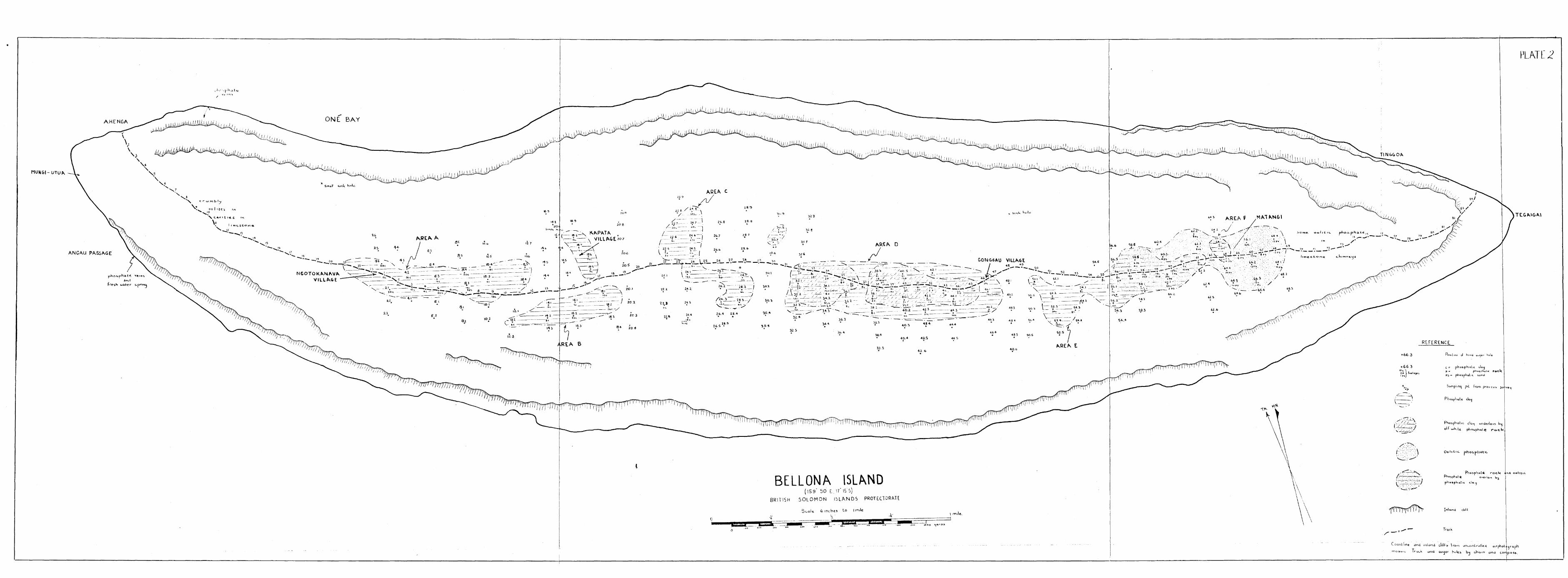
Plate 2 Bellona Island, showing the phosphate deposits. Scale 6": 1 mile.
Plate 3 Bellona Island, showing the phosphate deposits and isopachous lines. Scale 6": 1 mile.
Plate 4 Sections on Bellona Island.

..
SUIVlMARY
Bellona Island, British Solomon Islands, was visited by a survey team of the Bureau of Mineral Resources, as part of the search for phosphate deposits. The island is a raised coral atoll and has a phosphate deposit mostly of phosphatic clay, overlyingund infilling between limestone pinnacles and in . chimneys on the old lagoon floor. It is estimated that 4,500,000 tons of the clay with an average grade of 22.2% P205 and 700,000 tons of phosphatic sand averaging 30.3% P205 are recoverable. The bulk of material is rich in iron and alumina and its value as an economic deposit is doubtful •
INTRODUCTION
The investigation of the phosphate deposits of Bellona Island was undertaken by the Bureau of Mineral Resources under a Prospecting Licence issued by the Administration of the British Solomon Islands Protectorate. The investigation was part of the first six months field work of the Bureau's programme of search for phosphate deposits on islands in the Western Pacific.
The Bureau's Phosphate Survey party of two geologists -O. N.Warin and A. R. Jensen - and two field assistants, worked on the island for one month during April a.nd May 1958. W. C. White, Supervising Geologist, was with the party for a week at the beginning of this period.
Bellona Island is situated ninety miles south of Guadalcanal, at a position 1590 50'E, 170 15'S. It is one of the smallest islands in the British Solomon Islands Protectorate, being six miles long and two miles wid0, elongated in the direction eastsouth-east. The nearest island is Rennell, twenty miles to the east-south-east.
Bellona is surrounded by a fringing reef which is in few places more than fifty yards wide. The island is steeply shelving and there are no good anchorages but small vessels can hang on at the edge of the reef in One Bay and at Ahenga and Angau (Plate No.1) in f~vourable weather conditions. The best time of year to visit the island is during the lull between the end of the north-west season and the beginning of the south-east
• season. This lull usually occurs during April and May. Landing at other times of the year is possible but may be difficult. Landing is by surf boat on to the beach or the edge of the reef, depending on the state of the tide.
The island is inhabited by about 300 people of Polynesian descent. Their villages are spaced out along a wide central track which runs the length of the island and which gives good access to the low lying central area. Fairly dense forest covers some parts of the island, particularly around the rim, but large areas in the centre have been cleared and cultivated. No rainfall figures are available. The climate appears to be relatively dry and nonseasonal.
Fresh water is very scarce on the island. Several small springs of rather bracl{ish water occur just above sea level at the foot of the outer rim, e.g. Angau., but for the most part the inhabitants collect rainwater. Two auger holes drilled during the survey intersected wet clay and might provide a small supply of relatively good water if deepened into the underlying limestone.

- 2 -
PREVIOUS INVESTIGATIONS
Bellona Island was apparently discovered by Captain Butler of the "Walpole" in 1801. Although the neighbouring island of Rennellwas investigated by Stanley in 1927 (Stanley, 1929) and traces of phosphate noted, Bellona does not appear to have been investigated until 1956 when both Rennelland Bellona were visited by Grover (Grover, 1956, 1957, 1958). On Bellona nodular to crustified and man~ilary phosphate rock containing up to 73.3% tricalcium phosphate was found in veins and aavities in the limestone cliffs near Ahenga at the north-west end of the island, and a clayey material from a pit nea.r Ngotokanava
.. village was found to contain up to 50% tricalcium phosphate.
A second visit was made by Grover later in the sa.me • year when over 30 pits were sunk to depths up to 28 feet.
•
Subsequently a more extensive programme of pitting was carried out (unpublished report) which showed that a large tonnage of phosphatic material existed and that, although the bulk of the material was ' highly aluminous, high-grade phosphate rock and incoherent phosphate occurred at thG base of the deposit, the full extent of which was unknown.
PHYSIOGRAPHY AND GENERAL GEOLOGY
Bellona Island is an elevated coral atoll raised to approximately 250 ft. above sea level. It is elongated in an east-south-east direction and consists of a relatively narrow, flat central depression surrounded by a wide, double rim of limestone. The outer rim is approximately 135 ft. above sea level, the higher inner rim 260 ft. above sea level. The outer rim is almost continuous and is generally extremely steep on the seaward Side, with a prominent wave-cut notch at about 100 ft. above sea level marking an early stage of emergence. A more recent emergence is represented by a narrow terrace at 10 ft. above sea level, outside which is narrow, shallow lagoon and a low fringing reef.
From the inner, higher rim, which is deeply notched in several places, notably near Tinggoa and at Angau, the rough, deeply etched limestone drops steeply to the flat soil covered floor of the central depression, which rises gently from about 50 ft. above sea level near Ngotokanava village to over 100 ft. above sea level, towards the north-west and higher still towards the south-east ends of the island.
There are no drainage channels on the island and no run-off was noted during infrequent heavy storms. A few small sillie holes were found in the limestone on the inner slopes of , the rim but little evidence exists at the surface of any major sink holes in the central depression although drilling in the phosphate deposits, which blanket much of the central area, suggests that the phosphate cow~only fills large collapse structures in the limestone.
Although evidence of erosion by solution is present on the inner slopes of the rim it does not appear to be strong enough to suggest that the entire central depression was formed in this way. It seems more likely that the central depression represents a former atoll lagoon, which may have been deepEmed by solution erOSion, after emergence.

..
•.
- 3 -
The island has a slight but distinct tilt towards the north-west which, as pointed out by Grover (1958) contrasts strongly with the marked south-easterly tilt of nearby Rennell Island. On Bellona the tilting is most noticeable in the central valley and on the inner riD. It is less app~rent on the 100 ft. wave cut notch and is absent on the 10 ft. terrace which suggests that it took place at an early stage of the islands encrgence. The tilting of Bellona and Rennell in opposite directions, together with the differential emergence of the two islands (Grover, 1958) indicates that emergence was mainly due to tectonic uplift rather than to a general lowering of sea level. The tilting, as will be shown later, may have an important bearing on the distribution of the phosphate depOSits on Bellona.
PALAEONTOLOGY
Microfossils from limestone samples collected by Grover indicate an age not older than Pleistocene (Crespin, 1956A, 1956B). The forms identified include Lithothamnium, Halimeda sp., Operculinella venosa, Orbulina universa, Globigerina sp., and some indeterminate corals and bryozoa.
SAMPLING AND TESTING METHODS
The phosphate deposits were tested by a programme of drilling and saDpling designed to cover the entire soil-covered area of the central depression. Hand operated augers were found most suitable for this purpose. Holes were drilled every 300 ft. on lines 600 ft. apart at right angles to the main access track along the island.
The total footage drilled was approximately 1900 ft., the deepest hole being 36 ft. Sarnples were taken at 2 ft. intervals in the holes and all holes were continued until they bottomed in limestone. A representative number of samples 'Nere analysed for phosphate in the field by a rapid method involving the preCipitation of the arunonium phosphomolybdate and measurement of the vol~~le of precipitate after centrifuging. Though not accurate, the method was found to give a good indication of the grade of material being .tested •
THE PHOSPHATE DEPOSITS
The phosphate deposits occupy a large part of the central depreSSion, covering an area of approximately 340 acres. They occur as blanket-like depOSits overlying a highly irregular limestone surface and filling chimneys, crevices, and possibly large sink holes in the limestone. The individual deposits, A to F on Plate 2, are separated froD each other by wide outcrops of coralline limestone containing steep sided, narrow chiY.'llleys and pockets filled with phosphatic material. There is every reason to believe that the deposits were once continuous over the entire central depression but that solution of the underlying limestone and leaching and compaction of the phosphatic material has resulted in lowering ofthe surface of the deposit to the stage where the phosphate remains only in the deeper parts of the basin.
The floor of the deposit shows considerable relief which makes the estimation of tonnages difficult. Several of the pits sunk by Grover (1956 and unpublished reports) entered

.9
•
- 4 -
deep chimneys in the limestone, some of them 10 or 11 feet deep and only 2 to 3 feet wide, and many of the auger holes drilled in the presont survey Day have done the; sawe, giving a false · impression of the thickness of the deposit. Indeed sevoral auger holos are l{nown to have bottomed in narrow chimneys and all isolated deep holes IilUst therefore to treated with susp~cion.
The limestone outcropping around the deposits also contains Dany phosphate filled chinmeys and cavities. A few of these were found by drilling and pitting to be up to 8 or 10 feet deep, but the great majority were only one or two feet deep. In addition, the limestone outcrops are fairly flat; it is only on the top of the rim that anything approaching the typical karrenveld pinnacle fields is seen, and it see~s reasonable to conclude that the floor of the phosphate deposits is similar. The limestone underlying the depo sit is undoubtedly extensively solution etched, but DOst of the cavities are probably shallow and the irregulari tic;s fairly bro"?,d although apparently still steep sided. Many of the deeper parts of the deposits may represent infilled (with phosphate) sink holes.
The phosphatic material of the deposits is of three distinct types. Coherent phosphate rock~ is found, irregularly, at the base of the deposits and represents replacement of the limestone by phosphate. It occurs as a thin layer, nowhere more than about 2 ft. thick, on top of the fresh limestone, but is not everywhere present; it is ElOSt comIIwn towD.rds the southeast end of the island.
Incoherent or oolitic phosphate is found in chi~eys and crevices in the limestone at the north-west end of the island and as a blanket-like deposit in the vicinity of Matangi village (deposits E and F). It is not found to any great extent in the other deposits.
By far the greatest tonnage of Phosphate occurs in the form of a stiff, yellow-brown phosphatic clay, forming a thick blanket over the limestone and the coherent and incoherent phosphate. It is very uniform in appearance throughout the deposits although the top six to twelve inches is usually darker coloured due to humus. In a few places in deposits D
• and E the clay became slightly gritty and oolitic towards its base and appeared almost to gr~de into the underlying oolitic phosphate.
Traces of ar.orphous tricalcium phosphate (nauruite) were found in thin veins and as nodules in the sea cliffs near Ahengaand Angau.
THE PHOSPHATIC ~~TERIAL
The phosphatic clay which makes up the bulk of the depOSits is a damp, tenuous material, yellow-brown in colour and generally even-textured. It averages 22.2% P205 (360 determinations) and is high in iron and alumina. Aver~ge content of Fe~03 is 10 to 12%, and A1203 is comnonly over 30%, reaching 39.6/c in one case (A36/2-4 ft.). The ratio of Fe203 to A1203 is fairly constant, and this, together with the constanily low CaO/P205 ratio, low C02 and high loss on ignition,
* Under the term "phospha.te rock" is included friable or crumbly, even-textured, buff coloured phosphate as well as the more normal hard phosphate rock.

•
- 5 -
suggests that much of the phosphate may be present as the hydrated iron and aluminium or iron-alumino phosphate, which would also account for the low fluorine content (see Table 1). Optical and X-ray determinations confirmed the presence of the T:1inerals collophane (tricalcium phosphate) and crandallite (calcium aluminium phosphate) but no iron-beartng minerals were identified.
typically The coherent phosphate iSla fair~y soft, pale cream to
off-whi te, rather cavernous rock. It conullonl;y contains up to 39% P205 (average of 23 determinations = 33.8%) with less than 2% of Fe203+A1203 (one analysis), is high in fluorine and has a high CaO/P205 ratio with a very low C02 content, indicating that it consists almost entirely of tricalcium phosphate. This is confirmed by optical and X-ray examination in which only collophane and a small amount of calcite were found •
The oolitic phosphate of deposits E and F contains 29.2% P205 (average of 70 determinations) with some samples containing as much as 39% P205' Fe20~ is relatively low at 2.9% (average of 5 determinations) but AI203 is very variable, ranging from 1% to 15.3% with an average of 9.6% (5 determinations). The fluorine content lies between that of the clay and that of the phosphate rock. The CaO/P205 ratio is relatively high and C02 is low, and loss on ignition is fairly high, suggesting that the material raay be composed of tricalcium phosphate with some hydrated iron an~luminiurJ phosphates, although only collophane was determined by X-ray work.
Under the microscope the oolities were shown to be fairly small and very uniforn in size, with a well-dofined oolitic structure marked by concentric iron-rich rings. In no case could any nuclei to the oolites be detected.
No analyses or other deteroinations have yet been made on the underlying linestones, but a partial analysis was carried out on a water-saturated white clay found belovl the phosphatic clay and coherent phosphate rock at a d~pth of 15 ft. in hole A46/1. The analysis is shown in Table 1. The high magnesia (13.1%) and lime (37.9%) and low phosphate (15.8%) suggest that the clay may be composed of a calcium-magnesium phospho-carbonate and probably represents replacement by phosphate of a dolomitic marl.
THE INDIVIDUAL PHOSPHATE DEPOSITS
Deposit "A" near the village of Ngotokanava covers an area of 60 acres. The deepest hole drilled went to 26 feet in phosphatic material and several others were more than 20 feet deep. On the other hand several holes drilled in the centre of the deposit entered limestone at 4 to 6 ft. depth, showing that the bottom of the deposit is very irregular. The true maximum depth of the depOSit, allowing for test holes which may have bottomed in chimneys or crevices, is probably about 20 ft.
The material in this deposit is almost entirely the phosphatic CleW which generally rests directly on the limestone with very little replacement of the limestone by phosphates. A very thin layer of phosphate rock and traces of oolitic phosphate were seen in a few of the deeper test holes (Al/4, A4, A9), but mostly the contact between clay and limestone is sharp,
th:mgh irregular.

e'
- 6 -
To the north-west of Deposit "A", along the main track to Ahenga many shallow pockets in the limestone are filled with a crumbly, rather clayey, brownish coloured oolitic phosphate containing 30-34% P205 and about 10% (FeAl)203 (Grover, 1956).
Deposit "B", near Kapata village, consists of two small, shallow basins filled with phosphatic clay, and several small clay filled pockets in the adjoining limestone, with a total area of 33 acres. South of the main track the clay reaches a depth of 26 ft., but again the base of the deposit is highly irregular and it is knovm, from the earlier pits, that chimn8Ys 9 or 10 feet deep occur Ullder the depOSit. The clay is again very uniform and rests directly on the limestone \vi th no sign of phosphatization of the latter.
Fairly large pockets of clsy to the north and west of Kapata village appes.r to be infilling an old sink hole. Between Deposi ts "A" and "B" and between "E" and "C" Q.any snallo'll solution hollows and deeper chimneys (up to 10 to 12 ft.) in the limestone are filled with phosphatic clay with no trace of oolitic phosphate or phosphntized limestone.
Deposi t "c" is a shallow, irreguL'l.rly shaped body composed mainly of the phosphatic clay, and approximately 37 acres in extent. ]'ew of the test holes went beyond 6 feet in phosphate except at the north end of the deposi-1jWhere four adj oining holes were drilled to a depth of nore than 20 feet. Two of these were located close to the margin of the deposit and it is believed thnt this portion of the deposit occurs in ~ broad steep-sided sink hole or solution hollow more th~ 20 feet deep. -
In the deeper parts of this deposit the clay rests directly on white limestone, but elsewhere there is a thin layer, froQ. a few inche s to two feet trri ck; of phosphate roc]{ between the two. This tends to support the view that the deep portion represents an old sink hole where the phosphate solutior.s would have been carried [1way before they could replace the limestone.
Deposit "D", with an area of 106 acres, is the largest single deposit on the island. It is uniformly thicker than any of the other depOSits and, except on the extreme edge of the deposit is nowhere less than 8 feet thick, with several deep areas extending down to more th8.n 20 feet. It is steep sided, commonly going down to 20 feet or Hore within a few feet of the margin, and the drilling results together with the sections exposed in Grover's pits suggest that the bottom, though irregular and uneven, is not deeply pocketed. The test holes therefore ind.icate the true depth of the deposit iYl f,lOst cases.
The bulk of the phosphate .3.gain occurs as tLs phosphatic clay, but most of this clay deposit is underlain by 2 to 3 feet of coherent phosphate rock. In one or two holes more than 4 feet of phosphate rock was recorded but this may be the result of intersecting this horizon at an acute angle on the undulating floor of the deposit. In general the layer of phosphate rock is thinnest, or is absent, in the deepest parts of the deposit . .
The junction between clay and phosphate rock appears generally to be sharp and well defined, but in a few instances the phosphatic clay becomes slightly gritty and oolitic near the base and contained scattered small fragments of phosphate rock.
At one place, near hole A46/1 the phosphate rock is underlain by the water-saturated white clay referred to previously.
- 7 -
Deposi ts "E" and "F", between Gonggau and Matangi vil12vges, are continuous is outcrop and together cover an area of approximately 100 acres. Deposit "F" consists entirely of incoherent or oolitic phosphate and is in part overlain by the phosphatic clay of Deposit "E".
Deposit "E" occupies two well defined, deep, steep sided basins, both of them over 15 feet deep. The larger western basin was tested to a depth of 34 feet in phosphatic clay. It is roughly conical in shape, but slightly elongated in a north-south direction and the cluy rests cirectly on apparently solid, i. e. uncreviced, limestone. In the eastern portion of this deposit the clay reaches a maximum depth of 16 feet and is underlain by up to 12 feet of buff-colcured coherent phosphate rock and oolitic phosphate, which is here included in Deposit "F".
Deposit "P" occupies an extension to the east of the eastern basin of Deposit "E" by which it is in part overlain. It is up to 18 ft. thick and consists entirely of phosphate rock
and oolitic phosphate. The former is predominant where the deposit is overlain by the clay of deposit "E", and the oolitic phosphate is predominant in the eastern, outcropping portion. To the east of this area scattered chimneys and other solution hollows in the limestone are filled with the oolitic phosphate. Where the phosphatic clay overlie s the oolitic phosphate tlh.'. one clearly grades into the other.
ECONOMIC CONSIDERATIONS
The tonnage of phosphatic material available in the Bellona deposits has been calculated from the thickness contours or isopachous lines shO\VIl on Plate 3. In constructing these contour lines the probably etched and pitted nature of the underlying limestone surface has been taken into account and isolated deep test hcles have been ignored. Where three or more deep holes occur together it is assumed that they have all penetrated the same broad depression rather than that each has bottomed in a separate narrow chimney or crevice. Nevertheless it is probable that the bottom of the deposits may be rather Bore irregular than is indicated by the drilling and pitting, and that small limestone pinnacles may project up into the lower part of the depOSits.
The calculated tonnages must therefore be cut by a substantial factorto approximate the available tonnage. A cut of 50% has been used in the case of the phosphate rock and oolitic phosphate at the base of the deposits, and 25% in the case of the thicker phosphatiC clay.
The calculated tonnages and average grades are as follows:

- 8 -
1. Phos~hatic clal: on basis of approx. 15 cu. ft. = 1 ton.
Deposit Surface area Calculated volume Tonnage in s9. ft. in cu. feet.
A 2,632,000 20,964,000 1,400,000 tons
B 1,446,000 10,336,000 690,000 II
C 1,637,000 10,710,000 714,000 II
D 4,656,000 30,150,000 2,010,000 " E 2,819,000 20,138,000 1,342,000 "
TOTAL 13,190,000 92,298,000 6,156,000 tons
Calculated tonnage = 6,156,000 tons
Less 25% cut = 4,600,000 tons
Average grade (of 360) = 22.3% P205.
2. Phosphate rock and oolitic phosphate: Approx. 20 cu. ft. = 1 ton.
Deposit
D and F
Area in sq. ft. Calculated volume Tonnage in cu. ft.
5,500,000 28,740,000 1,400,000 tons
Calculated tonnage = 1,400,000 tons
Less 50% cut = 700,000 tons
Average grade (of 93) = 30.3% P205
The total of both types of material is equivalent to 5.3 million tons of 23.3% P205•
The low grade of the deposits compared to Ocean Island and Nauru depOSits, together with the high iron and alumina of much of the material probably rule it out as a source of phosphate for manufacturing superphosphate. It is pOSSible, however, that under suitable conditions the material could be used for direct applicationtto the ground. Similar phosphate from former Japanese TIlandated islands has been used in the past (Yoneyama, 1923, non vide),
Exploitation of the material should not be difficult. Access to the depOSits from the anchorage at Ahenga is relatively easy and, although the anchorage is poor, it is reasonably sheltered during the season of south-easterly winds. Timber is plentiful on the island and the shortage of water could be overcome by construction of storage t &nks. Underground water is probably not very plentiful and is likely to be of poor quality.
THE FORMATION OF THE PHOSPHATE DEPOSITS
The phosphate deposits on Bellona are undoubtedly derived from guano deposited by breeding sea birds possibly in late Pleistocene or early Recent times. The phosphate rock at the base of the deposit has been formed by replacement of the

- 9 -
limestone by solutions leached out from the guano to form tricalcium phosp·hate. The origin of the oolitic phosphate and phosphatic ' clay is however, more problematical and no clear explanation of this type of deposit seems to have been forward.
In describing the very similar deposits on Angaur in the Caroline Islands, Rogers (1948) suggested that the oolites were concretionary and formed in the clay, while Irvine (1953) held the view that the oolites, formed by replacement of limestone oolites, were washed into the lagoon and decomposed to form the phosphatic clay. Neither author s eems to have put forward a great deal of evidence in support of his ideas.
From observations made on Bellona and from subsequent laboratory work, as yet incom, lete, the following geological history is suggested for these depOSits.
The island was formerly, probably in the late Pleistocene, a low lying coral at oll elongated in the direction of the prevailing wind, i.e. east-south-east. Elevation and slight tilting to the north-west cut off thelagoon from the sea and confined it to the north-western end of the island. Drainage was along the axis of the island, from the higher south-east end into the rapidly dwindling lagoon. VVi th the final disappearance of the lagoon due to evaporation and underground seepage, the drainage went underground and subsequently the main drainage axis was marked by a line of great solution hollows, sink ho18s and other collapse structures in the limestone.
At about this stage, or perhaps even earlier, the uplifted atoll was colonised by hordes of breeding sea-birds and a thick deposit of guano accumulated, mainly on the inner slopes of the rim of the island. Solutions leached from the guano attacked the limestone to form a mantle of tricalcium phosphate with a distinct concretionary or oolitic structure. (Specimens of coherent phosphate rock from Bellona and from Christmas Island all showed a distinct oolitic texture under the microscope). With subsequent weathering and erosion the oolitic rock was broken down and the oolites, together with "terra rossa" soils derived from the solution erosion of unaltered limestone, were gradually transported into the sink holes along the axis of the island and a thick blanket deposit of loose oolitic phosphate was formed on the old lagoon floor.
With the choking up of the sink holes by this relatively insoluble phosphate, conditions within the ce :;.tral depression became swampy and, due to the presence of humic acids, fairly acid. Decomposition of the oolites began with breakdown of the oolitic structure and leaching out of the tricalcium phosphate. Some of the phosphate was lost, through underground drainage, to the sea, some was reprecipitated in small fissures and cavities in the limestone (e.g. Angau and Ahenga) and much of it recombined 'vvi th the iron and a lumina of the "terra rossa" to form the more insoluble iron-alumino phosphates forming the phosphatic clay.
This process of decomposition of the oolitic phosphate, which is probably continuing even now, began at the surface where the humic acids were mora abundant and proceeded downwards to the base of the deposit. Decomposition was more complete towards the lower north-west end of the island and, to a lesser extent over the deep sink holes where percolation of the acid waters was more rapid. Further away from the sink holes and particularly near the higher south-east portion of the island the oolitic phosphate remains.

- 10 -
ACKN01fVLEDGMENTS
The assistance given to the survey party by J. C. Grover &nd staff of the Geological Survey Department is gratefully acknowledged.
REFERENCES
CRESPIN, I., 1956A - Report on samples from Rennell and Bellona atolls, Solomon Islands. Aust. Bur. Min. Resoor.Records 1956/50 (unpubl.)
___________ , 1956B - Report on rock samples from Rennell and Bellona Islands. Aust. Bur. Min. Resour. Records 1956/92 (unpubl.)
GROVER, J.C., 1956 - The Solomon Islands. Goological Exploration and Research 1953-56. Gaol. Surv. Brit. Solomon Islands Mem. No.2.
____________ , 1957 - Some geographical aspects of the British Solomon Islands. Geogr. Journ. 23, 3, 298-317.
____________ , 1958 - The Geology of Rennell and Bellona. The Natural History of Rennell Island, COPENHAGEN. Vol. 3, 103-119.
IRVINE, E.M., 1953 - Problems in the origin of phosphate ore from Angau Island (in &bstract). Proc. 8th Pacific Sci. Congr.
ROGERS, J., 1848 - Phosphate deposits of the former Japanese Islands of the Pacific. Econ. Geol. 43, 400-407.
STANLEY, G.A.V., 1929 - Report on the geological reconnaissance of Rennell Island. British Solomon Islands Report 1927. Annual Col. Rep. 1421, 13-25.
YONEYAMA, C., 1923 - Utilization of aluminium phosphate ore. Chigaku Zas8bil, 35, 413 1 259-290 and 414, 348- 351.
TABLE I.
PARTIAL ANALYSIS OF PHOSPHATE SAMPLES FROM BELLONA IQLAND
"a:r:rple Type of Material P205 CaO CO 2 Loss on F Fe203 A120 3 Ti02
CaOI Remarks 1\ 0. Ignition P205
.iU2-20' Phosphate rock 39.1 52.7 0.40 1. 82 4.67 0.55 1.1 n.d. 1.34 A6 '~/4-10' Oolitic phosphate 31. 4 32.5 0.66 11.1 2.04 4.57 14.5 0.24 1.03 A64/4-14, Oolitic phosphate 29.8 32.4 1.02 10.9 2.04 4.26 15.3 0.2 1.08
A60/3-4' Oolitic phosphate 35.9 45.6 0.84 6.67 3.46 1.52 3.2 n.d. 1.28 A68-8' Oolitic phosphate 31·.3 34.3 0.77 11. 9 1. 83 3.85 13.9 0.1 1.09 .A57-20' Phosphate rock 38.6 52.8 0.24 1. 82 3.70 0.65 1.0 n.d. 1.36 A16/2-6' Phosphatic clay 25.1 10.4 0.13 17.1 0.31 10.5 31.8 0.60 0.41 A16/2-22, Phosphatic clay 24.6 10.3 0.13 18.1 0.10 10.1 33.1 0.45 0.42 .il.2 l}/5-8' Phosphatic clay 26.4 10.9 0.12 16.7 0.41 9.41 30.3 0.55 0.41 A36/1-5' Phosphatic clay 30.4 39.8 1.91 7.82 2.42 2.96 7.8 0.10 1.30 Sample heated
during field assay.
A36/2-4' Phosphatic clay 19.8 7.86 0.07 17.4 0.21 11. 2 39.6 0.50 0.39 A44/3-8' Phosphatic clay 24.6 10.6 0.10 17.2 0.36 10.4 34.8 0.5 0.43 A6/3-6' Phosphatic clay 24.2 10.3 0.06 17.1 0.31 8.91 33.5 0.45 0.42 "V~6/1-15 ' Saturated white 15.8 37.9 14.75 12.2 1.91 0.6 1.8 n. d. 2.4 MgO = 13.1%
clay.
Loss on ignition C950 0 C) does not include CO2 , All results refer to samples dried at 1050 e.
Analyst: S. Baker.

(a) (b) (0)
Auger Hole
2' 0
4' c 6 ' 0
10' c 12' 0
14' 0 16' 0
B.22
4 8 8
21 19
7 18
Auger Hole A4/2
2' c 7 4' 0 20 6' c 19 8' 0 24
10' 0 22 14' 0 37 16' 0 37 18' 0 8 20' 0 15 22' 0 28 26' 0+1 27
Auger Hole AI0/4
2' 0 22 4' 0 23 6' 0 14
10' 0 15 12' 0 12 14' 0 22 18' 0+1 21
Auger Hole A16/2
2' 0 15 4' 0+1 13 8' 0 12
10' 0 17 14' 0 26 16' 0 27 20' 0 26 26' 0+1 31 22' 0 22
6' 0 25
(a) (b) (c)
Auger
2' 4' 6'
10' 12 ' 16' 18'
Hole B.2]
c 7 c 27 c 25 c 23 o 27 o 25 o 21
Auger Hole A5/0
2' 0 24 4' c 20 6' 0 17 8' 0 17
12' 0 19 14' 0 22 16' 0 24 20' l+p 27
Auger Hole A12/1
2'
Auger
2' 4' 6'
10' 12 ' 14' 18' 20' 22 ' 24'
o 22
Hole ),.16/8
c 9 o 10 o 10 o 10 o 9 o 10 o 11 o 10 c 10
0+1 11
1 st column (a) - :DeTrtll of s2r.l-pl e 2nd column (b) ._- ~i thology of sa!rr;)le c - clay
3rd columrc (c) .- %
(a) (b) (0)
Auger
4' 8'
12'
Auger
2 ' 4' 8'
12' 14'
6'
Hole Al/O
c 17 c 23 c 24
Hole A6/3
o 21 c 27 c 25 o 22 o 22 o 24
Auger Hole A12/2
2' 0 8
.hUzer
2' 8'
12 '
Hole "~18/1
c 12 o 8 o 33
(a) (t) (0)
Aw:-;;er Hole A2/0 2' 4' 6' 8'
10'
c c o p
25 23 13 21 33
Auger Hole A8/0
2' c 17 4' c 23 6' c 21
14' 1 6 15}' 1 0
Auger Hole A12/1
2' c 24 4' c 16 8' c 22
10' c 13 14' c 2~-16' 0+1 15
, Hole ~13/2 J~uger .._
2' 4' 6' 8'
10' 15' 17' 18' 20' 22 ' 26'
c o c c c
c+l 0+1
o c c
20 19 20 19 18 10 17 18 19 19 15
(n) (b) (c)
Auger H~)le A2/1
2' 0 18 4' 0 20 6' 0 15
10' 0 15 12' c 6 14' 0+1 19 18' 0+1 23
Auger Hole A8/3 2' c 20 4' 0 21 6' c 29
12' 0 29 14' op 27 18' op+l 28
op - oolitic phosphate p - phosphate rock 1 - lime 3tone
(a) (b) (c)
Au?,cr Hole A2/4
4' c 10 8' c 18
10' c 26 18' 0 27 20' c+op 21 2' e 17
Auger Hole A8/4
2' 0 23 4' 0 21 6' e 21 8' 0+1 25
12' 0 20 14' 0 17 20' 0+1 17
Auger Hole A12/5 Auger Hole AI L/l f~ , 0 23 2'
4 ' 6'
10' 12 ' 14' 18' 20'
2' 4' 8'
c c o c
c c
0+1
21 22 21 18 28 20 23
5
Hole A18/5
o 3 f!-o 29 o 29
8' 0+1 15
Auger
2' 4' 6'
10' 12 ' 14' 20' 21' 22' 24' 26'
Hole A18/6
o c o o c c o
o+p o c o
26 30 22 29 30 25 25 25 23 24-21
(a) (t) (c)
Auger Hole A3/0
4' 0 21 12 ' o+p 19
Auger Hole
2 ' 0 4' c 6' c 8' c
10' c 12' 0
1.+ ' o+p 16' c+p
A9/0
23 22 23 20 25 24 21 23
Auger Hole A14/2 4' c 17
;1.uger Hole A18/7
2' 0 26 L~ , 0 22 8' 0 23
10' o+p 26
(a) (b) (c)
Auger Hole A4/0
2' 4'
o o
20 o
Auger Hole AI0!3 2' o 28
Auger Hole :1.16!1
2' 0 21 4-' 0+123
2' 4' 8'
10' 14'
o o o o c
18 16 16 24 17

T~LE 2 (Cont'd.)
(a) (b) (c)
Auger Hole 11.20/0 2' 1+0 Nil 3i' 1 Nil
Auger Halo A24/5
2' 4' 6'
10' II' 8'
c c c C
c+p c
28 27
19 27 26
Auger Hole A28/3
2' 4' 6'
Auger
2' 4' 6' 8'
a p 1
25 23
Nil
Halo A32/0 c 16 c 17 1 8
l+p 26
(a) (b) (c)
Auger Hole A22/3 2' 6'
10'
c c c
20 16 15
Auger Hole A24/6
2' c 21 4' c 19 6' c 24-8' c 22
10' c 28 12' c 27 14' c 19 18' c+p 27 20' c 25 22' c 22 24' c+l 26 26' c+p 30
Auger Hole A28/4 I' 1 Nil
Auger Hole 1',.34/0 2' c 22 4' c 23 6' c 27 8' c 22
12' P 37
(a) (b) (c)
Auger Hole A22/5
2' c+p 31 4' p 29
Auger
2 ' ~r '
6' 10' 12' 18'
2' 4' 6' 8'
10'
Auger
2' 4' 6' 8'
10' 12 ' 14' 15' 17' 19'
Hole A24/7 c 22 c 14 c 18 c 23 c 24 c 20
c p p P
l+p
22 32 26 38 11
Hole 1,.34/1
c 23 c 25 c 26 c 18 c·: 19 c 22 c 22 P 39 p 39
p+l 15
- ii -
(a) (b) (0)
2' 4' 6'
AUGer
2 ' .' , 'r
6' 10' 12' 14' 18' 20' 22 '
c e c
26 20 16
Hole A24/8
c 19 c 20 c 18 c 20 c 20 c 21 c ]-9 c 19 c 21
liuger Hole idOlS
2' 4' 6' 8'
10' 12' 14' 16' 12' 20' 22' 2.'t' 26' 28'
2 ' 4' 6' 8' 9t'
c c c c c c c c c c c p p p
25 27 2,! 26 30 26 26 J!~ 22 22 23 37 32 35
Hole A3!;/2
c 22 c 17 c 27 c 16 p 24
(a) (b) (e)
2' 4' 6'
10' 12' 14' 16' 20'
n,)lc ",22/7
(; 22 c 22
22 (; ~~ 4
c+l 18 c 19 c 13 c 17
Auger Hole ~26/1
2' c 25 6' p 35
Auger Hole 1-d3/0
2' e 4-' c 6' c 3' c+J? 9'(end) 1
23 24
25 37
7
Auger Holo i1.35jO
2' I~ I 'T
6' 10'
c 25 c 30 p 39 P 31
(a) (b) (c)
2' 4' 6'
2' 4- ' 6' 7 '
11' 13'
Auger
l' 3' 5'
c 20 J
c 22 c+p 32
Hele i1.26Ll.
c 28 c 28 c 14 p 28 c 21 p 30
Hole 1;.32/1
c 28 c 14 p 30
.t·,uger Hole
4- ' c 6' p 7' 1
25 34
7
(n) (b) (c)
Auger Hole 1.24/1
2 ' c 4' c 6' c 8' c
10' l+c
23 23 21 16 21
Auger Hole A28/1
6' c 18
Auger Hole A32/2
2' 4' 6' 8'
c 28 c 29 p 31 P 27
lcuger Hole A36/1
2 ' c 5 ' c 7' c
31 30 35
(a) (b) (c)
Auger Hole 1-,.24/4
2 ' 4' 6' 8'
la' 12' 1 LL ' ~ 0
16'
c c c c c c c c
22 20 22 17 22 21 19 21
Auger Hole A28/2
2' c 4' c 6' p
19 18 35
Auger
2' 4' 6' 8'
H\~le .t~32/3
c 18 c H3 c 24 c 21
liuger Hole A36/2 2' c 18 4' c 20 6' c 15

TJJ3LE 2 (Cont'd)
(a) (b) (c)
Auger Hole ;,36/3
2' c 6
j,uger Hole .A.40/1
2' 6' 9'
c c p
25 25 30
Auger Hole .A.44/2
2' 4' 6' 8'
11'
c c c P 1
25 27 22 36 8
Auger Hole I,48/2
2' 4'
c c+l
18 23
(a) (b) (c)
~uger Hol~ A37/0
2' 4' 6' 8'
c c 1 1
24 30 15 Nil
Auger Hole 1':,.40/5
2' 7'
c p
23 33
l':..uger Hole ":"44/3
2' 4' 6' 8'
10' 14'
c c c c c 1
17 15 18 25 21
2
l',.uger Hole 1~t~8/3
4' c+l 5
(a) (b) (c)
2' 4' 6' 8'
l .. uger
2' 4' 6' 8'
c c+l
P P
28 23 36 32
c 26 c+p 20
p 27 1 Nil
}J.uger Hole .A.44/4
Surface 1 1
Augor Hole 1~50/0
Ii' 2' 4'
c 0+1 c+l
23 14 16
(iii)
(a) (b) (c)
~uger Hole ~38/2
!~ ,
8' 10'
c 1 1
23 6
Niili
Auger Hole h42/0
2' c 12 4' c 28 6' c 2,) 8' c 28
10' c 18 12' c 16 14' c+l 26 16' c 23 18' p 37 20' p 39
Auger Hole 4:~/5
Surf'3-ce c 3
2' 4' 6' 8'
10' 12' l!e' IG' 13' 20' 22' 2,~ , 2G' 2i3'
c c
c+p c+p
c c c
c c c c c c
21 17 25 19 27 32 22 32 30 32 33 35 3! 32
(a) (b) (c)
ll.uger Hole .\.38/5
4' c 6' c 8~' p (coherent 8i' p
26 28 40 rock) 37
J'~ugGr Hole lA2/1
2' c 17 ii-' c 15 6' c 14 8' c+1 11
10' c+1 11
;'uger Hole AL 5/0 2' ! , "
6' 10' 12'
2' 4' 6' 8'
10' 12' 14' 16' 18' 20' 22 ' ,0), ,
28' 30' 32'
c c c c c
c c c c c c c c c c c c c c c
22 23 21 17 33
26 26 25 25 26 23 21 21 28 19 2<-24 26 12 25
(a) (b) (c)
huger Hole .id8/1
2' 4' 6'
c c+p c+l
27 31 20
.i'~uger Hole 1~!i-2/3
2' 4' 6'
10' 12 ' 14' 16' 18' 21'
.huger
2' / , ..,. 6' 8'
10' 12' 14' 17' 19' 21' 23' 25' 27' 30'
c c c c c c c c p
16 14 28 25 30 27 21 20 33
Hole Jl-46/0 c 15 c 27 c 19 c 25 c 24 c 23 c 20 c 29 c 24 c 28 c 26 c 20 c 21 c 20
Auger Hole 1~52/ 4
2' 4-' 8'
10' 12'
c c c c
c+l
17 27 16 16 22
(a) (b) (c)
.:iuger Hole A39/0
2' c 4' p 6' 1
26 33 12
8' p 36 9' end 1 7
Auger Hole A43/0 2' 4-' 6'
c 22 p 27 1 1
il.uger Hole 1~4-6/1
2' c 1 4' c 17
10' c 24-14' p 34 15' satur- 24
atGd clay
16' satur- 16 ated p
Auger Hole A54/1
2' 4' 6' 7' 8'
c c c p c
24 35 23 25 25
(a) (b) (c)
Auger Hole ~40/0
2' 4' 6' 8' 9'
c c
c+p p p
26 24 32 30 32
il.44/0
2' c 4' c 6' c+l
29 30 19 19 8' c
Auger Hole ;"46/2
2' 4' 6' 8'
c 22 c 27 c 22 c 20
Auger Hole .A.54/3
2' ij- ,
6' 8'
c c c c
19 li 18 15
TABLE 2 (Cont'd).
(a) (b) (c)
Auger Hole A55/0
2' c 22 4' c 18 6' e 24 7' c+l 21 8' c 19
Auger Hole 1~59/0
2' c 26 t~ , e 20 6' e 24-8' c 26
10' e 25 12' e 23 14' c 23 16' e 21 18' P 34-22' P 37 24' p 29 26' p 24 28' P 35 30' p+l 7 34' p+l 6 37' p+l 11
Auger Hole 1'-..62/2
2' 1,c+op 19 6' or 29 8' op 26
12' op 34
Auger Halo A66/1
2' c 28 4' c 21 8' e+l 24
])eoponing of near .A60
20 I c 27 22' c 28 24' c+op 34 24~'c+op 30 26 ' op 31
Pit
(a) (b) (e)
li.uger Hole A56/0
2' e 19 4-' e 25 6' c+l 23 8' 1 7
10' p 37
Auger Hole J,60/0
2' e 25 4' e 24-6' e 22 8' e 20
10' e 8 12' e+p 21 14' e+p 32 16' op 31 17' Pebble 32 18' op 28 20' e+op 35
,~uger Hole ; ... 63/0
2' c+op 26 !~, l+op 29
Jiup;er Hole L66/2
2' 4' 6' 8'
10'
op op op op op
28 28 30 21 28
(a) (b) (e)
.huger Hoh: i1.56/1
2' c 25 19 27
4-' c 6' c 8' 1 9'10" P
2 37
Auger
2' Ii- '
Auger
2' 6' 8'
10' 12' 1.+ ' 16'
Hole A60/3
op 23 op 36
c 32 op 29 op 33 op 33 op 26 op 3"'r op 30
"',ugor Hol,; "~66/3
2' t· , r
6' 8'
10' 12' 13' 1:~ , 16' 1[;' 20' 21'
c c c c
op op op op op op op op
24-23 20 32 27 25 28 32 29 27 22 28
(iv)
(a) (b) (c)
h-uger Hole !,56/2
3' c 21 6' c 15 B I c 24
10' c 15 12' c 15 1,t' P 32
2' 4' 6' 0'
10' 12 ' -, - I ...L'"-
lG' 1 0, _~U
22 '
c c c
c C
c+T\ C
c c+op
iiui:~er Hc1c
2' I I
'T
6' 8'
10' 12' 14' 16'
2'
or op op op op op
op
21 20 :=6 1!;-26 26
"' -, J-'-
35 35
35 25 35 35 3(' 3·~ 35 32
28
(a) (b) (c)
1~u5er Hole 1~37 /0 2' ,~ , 6' 8'
10' 12' 16' 19' 20'
6'
,; , "r
6' 8'
10' 12' 1::;"
2' 6' 8'
c
0[1 op op op o-~-,
c
c c c c :r p
op+l
op op op
15 23 24-20 30 24-2~
'29 3S
15
33 27 32
60/5
2' 4-' 6' 8'
10' 12 ' 1.';.' 16' 18' 20' 22 ' 24' 26'
Luger
2' -' , 'T
6' 8'
10' 12' 1 L~_ ,
c c c c c e p c p p
r 1-
23 18 22 17 27 27 29 3 ,' '-,-
36 37 31
32
Hole A6l/0
c 21 e 2,t
c+op 29 op 25
p 32 p 32 p 35
Luger HolE ;"64/5
2' ! , 'T
6' 8'
30 21 28 25
i~ug(;r Hole ,~68/0
2' 6'
10' 12 ' 8'
op op op op op
29 28 31 31 31
(a) (b) (c)
huger Hols n58/1
2' " , "j-
6' 8'
10' 12 ' 14' 16' 18' 19~-t 20~·'
c e c c c c c c c p p
19 17 17 15 23 20 26 24 19 32 33
l~uger Hole "~62/0
2' c 17 ~ , 'T c 12 6 1
8' e 20 c 20
10' c+op 23
.huger Hole
2' op 6' op 8' op
10' op 12' op 14' op 18' op
i~65/0
33 26 35 27 26 28 34
Auger Hole 1~68/1
2' ~ , 'T
c op+l
17 21
(a) (b) (c)
2' 4' 8' 9'
op 25 op 18
c 26 1 7
Auger
2' 4' 6' 8'
op 26 op 31 op 24-op 25
j,uger Hole
fir' op 6' op 8' op
10' op 16' op 17' op 12' op 14' op
Ji66/0
25 27 18 30 23 30 30 29
Auger HclG ;\.68/ I;.
2' 5' 6' 8'
10' 12'
op op op op op op
') r:: '----)
31 20 27 26 31

-J . ., ~- - . c
" J
;; ItiO '
.... ---
s·
0
" G
'-vv "
~ ~
TERRITORY
of
NJEW (Qr UJlJ NJ IE #\
- - - - - - - - - -- -
~TROBRIAND
• 0 "
• ,1)
10'
o
o
160'
:"n 155' .~
.'0 •
a'
® '" .
/ ., / I
/
/ -------
LOUISIADE
• "'(p" . ARClH PELEGO ~ '" ,,".
' ~"Q:""." .. ~ ..
" ...... ' '''' '; "" . ,, '
. ....
.,/
~ ~ .~ /Q "
0'0
C?,
o
IbO' PLATE PART of
S . W. PACIFIC
S hO "" H1~
BELLONA , I.
SCALE I : spoo, uoo
BRITISH
~
PROTEC'TORATE
I •
BELLONA ISLAND
8 ~RENNELL 160'
1
S
•
MU"GI- UTU~
ANGAU PAS5A.G[
ph"'''ph'' tee ".,.1
he .. " ~.er
..j" -rh ", ~'" .. ""
BAY
!. ',1 '/
, /
... "F0 "I~
'J)J'~
I ""\':II,I"~ ,1lll'/I"."III,I,.I"I""I.~,:J.~ ~-
::1.3.
~ Ii i I ,iii/" '.' .... I, '/ I, i,'"
"'I' ,.
f '/ '1'/
I' .'
I
"
~"'.h \ ".-,'
'I,' I.' • ..
'"
BELLONA
I." "
ISLI\ND (159' 50 [ 1115 II
BRITISH SOLOMON I:'ILANOS PROT[cl,JRAT(
• ,i,ll, I \
"·L!~!"! ""'I I!!,'>'"'<' '"'p~
5:_~/' .'~~'
5.",1 61,1,
R[fER£NCf..
.0, } 2. ~ •• t.~,
'"
/'-::> /. \ ~:-'
dnd ",lund
",nd
,~ ph~~ph ol'e d~~ p • p"o,oh,,"l~ ~ ... ~k ,~- F'",o'Fh~l,< .unci
~hO~l'no.t'<
,,\f while C\Cl,\ ~ndHlo'" b'l
phCl~ph ... te ... ·o::..elo(
?\'o'ph .. tll ,,,,,,-I., Ph.~ph~t Qc c.~<IQ'~ bS
fh.~rho.tl~ d .. ~
d,H" 1,0'" ~n.()"L,~I\"d. ''''phor
"'''~~r h~I .. ~ b::l <..h""" un..t ,,,
TLG.et..IGA.I

~---------~. ----.-~---
'--~-"'" ( ( ,,"\ . , "" \. , \ \ \ r \. \ \ \ \.
\ , \ \ ,-\ ' ~/
I !
".
- _.-l~) --..
';
". \ \.
-- / (,- , / -' / ."
BELLONA ISLAND
" I
(ISquSO'E ''''''5'5) IC~AND::' PR.OTECTORA.TE. bfl.lTI ~ti SOLO MON 0
DCALE ,~ I ,~.\c
", '" - ", - - - ." ,~.o
I "".,. I
~ I
\. .., '.
\\
Isopac f1
[I,;,op ... <-h
I~O?!-("h
"1 phC5I'hat" (I"'-~ d"po~lt
'Mt~T"al : Sr.]
or' ocllbe: pho.phatp
3."d rhOsph ... ,,, roo:.lo.c
[ISop .. ",h '"~,,,r ... ,1 ,Sf,]
Inland ell ft
• D
PLATE 3
AREA M"'~CH,I \1"1",,, .. ('-- ,.)
A cI~::t 20,9':'+000
B cI"1 '0,3"",°00
C eel",,:! IO,~'O,O«l
D da';l ~o,'5'o,ooo
E d~~ :lO,!!>e,Qoo
oobt~I"''''''''''' li,7",0,,,,,,,, "' F ,.,
rh"'rh~'e "" k
r-- --.-.---
I I

i I
f[lT
140
\bO
,2.(;.
'0 ., n 1.\
, " ,
,
.1 -!
-~ .
'''n _ _ l lr'-Tf 1
L -J~T~~~J J ~-:~-'~1--:-. , '0 "
I~
D
, ,
.'
,
i J
"
! I
" . ~
z
Brown pIlo'ph"l,< <lo~
; . z
,. " "
BELLONA ISLAND ISLAND PROT[(]ORATE
z
, . r t:-
, " i
'l ~ c0-
. ~
. , ., .. .. .. "
EJ:···· ....... . ' ...
I ., r ~
l, l) ~ ~.c I "
I" ... tone
" .. " '0 ..
:\/ji: ,. ,-. 6-\ .. ';:. '- ...
I .' ...
' .. ~ I: .. '
;'1 ~ \ ...
$
PLAIE 4
z
100
t I
r l (1
, eo
., o • ..