John T. Cameron Pennsylvania State University Dr. Sean Brennan Pennsylvania State University

The Pennsylvania State University Watersheds Report
2020

The Pennsylvania State University Watersheds Report
i
Table of Contents
Introduction ................................................................................................................................................... 1
Overview of Major Basins ............................................................................................................................ 2
Penn State Points of Interest
Fox Hollow Drainage Basin ........................................................................................................... 11
Main Campus Drainage Basin ....................................................................................................... 12
West Campus Drainage Basin ....................................................................................................... 14
Bathgate Drainage Basin ................................................................................................................ 15
Airport Dam 1A Drainage Basin ................................................................................................... 16
Airport Dam 4A Drainage Basin ................................................................................................... 17
Foods Pond Drainage Basin ........................................................................................................... 18
Parking Lot 43 Drainage Area ....................................................................................................... 19
Corl Drywell .................................................................................................................................. 20
OMPEC Pond Drainage Area ........................................................................................................ 21
Poultry Pond Drainage Area .......................................................................................................... 22
Big Hollow Landscape Pond Drainage Area ................................................................................. 23
Cow Barn Pond Drainage Area ...................................................................................................... 24
Cato Pond Drainage Basin ............................................................................................................. 25
The Big Hollow Watershed .......................................................................................................... 26
Shavers Creek Watershed .............................................................................................................. 27
Test Track Drainage Areas ............................................................................................................ 28
Innovation Park Drainage Basins ................................................................................................... 29
Rocks Springs Area........................................................................................................................ 30
Orchard Road Drainage Basin ....................................................................................................... 31
Mitchell Tract Recharge Area ........................................................................................................ 32
Field Maintenance Building Pond ................................................................................................. 33
Centralized Biological Lab Pond ................................................................................................... 34
Softball Field Pond ........................................................................................................................ 35
Technology Support Building Pond ............................................................................................... 36
Low Head Weirs ............................................................................................................................ 37
Subsurface Detention Facilities ..................................................................................................... 38
Stream Segments on University Property ...................................................................................... 39

The Pennsylvania State University Watersheds Report
ii
List of Figures
Figure 1, University Lands in Area of University Park Campus .................................................................. 3
Figure 2, Major Watershed Divide near University Park Campus ............................................................... 4
Figure 3, Act 167 Stormwater Management Basins near University Park Campus ..................................... 5
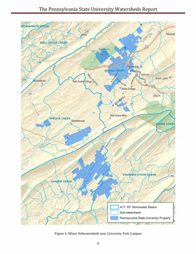
Figure 4, Minor Subwatersheds near University Park Campus .................................................................... 6
Figure 5, Subbasins of the Spring Creek Watershed ..................................................................................... 7
Figure 6, Spring Creek Watershed Surface Water and Groundwater Boundaries ........................................ 8
Figure 7, Streams and Creeks near University Park Campus ....................................................................... 9
Figure 8, The Relationship of the Four Primary Watersheds that Make Up the Core Campus .................. 10
Figure 9, The Relationship of University Designated Watersheds to Major Facilities ............................... 10
Figure 10, The Fox Hollow Drainage Basin and Significant Stormwater Facilities ................................... 11
Figure 11, Main Campus Drainage Basin ................................................................................................... 12
Figure 12, Duck Pond Drainage Basin Identified by Size of Storm Drain Pipe at WWTP ........................ 13
Figure 13, Relationship of the Thompson Spring and the Duck Pond ........................................................ 13
Figure 14, West Campus Pond Drainage Basin .......................................................................................... 14
Figure 15, The Bathgate Drainage Basin .................................................................................................... 15
Figure 16, Airport Dam 1A Drainage Basin ............................................................................................... 16
Figure 17, Airport Dam 4A Drainage Basin ............................................................................................... 17
Figure 18, Foods Building Pond Drainage Basin ....................................................................................... 18
Figure 19, Parking Lot 43 Pond Drainage Area .......................................................................................... 19
Figure 20, Location of the Corl Drywell ..................................................................................................... 20
Figure 21, The OMPEC Pond Drainage Area ............................................................................................. 21
Figure 22, The Poultry Pond Drainage Area ............................................................................................... 22
Figure 23, The Big Hollow Landscape Pond Drainage Area ...................................................................... 23
Figure 24, The Cow Barn Pond Drainage Area .......................................................................................... 24
Figure 25, The Cato Park Pond Drainage Basin ......................................................................................... 25
Figure 26, The Big Hollow Watershed Surface Water Boundary............................................................... 26
Figure 27, The Shavers Creek Watershed ................................................................................................... 27
Figure 28, The Test Tract Drainage Areas .................................................................................................. 28
Figure 29, The Innovation Park Drainage Basins ....................................................................................... 29
Figure 30, The Rock Springs Drainage Area .............................................................................................. 30
Figure 31, The Orchard Road Drainage Basin ............................................................................................ 31
Figure 32, The Mitchell Tract Recharge Area ........................................................................................... 32
Figure 33, The Field Maintenance Building Pond Drainage Area .............................................................. 33
The Pennsylvania State University Watersheds Report
iii
List of Figures (continued)
Figure 34, The Centralized Biological Lab Building Pond Drainage Area ................................................ 34
Figure 35. The Softball Field Pond Drainage Area..................................................................................... 35
Figure 36, The Technology Support Building Pond Drainage Area ........................................................... 36
Figure 37, Low Head Weir Drainage Areas ............................................................................................... 37
Figure 38, The Drainage Areas to the Subsurface Detention Facilities in the Core Campus Area ............ 38
Figure 39, Overall Plan of Streams Owned by the University in the Centre Region .................................. 39
Publisher: Penn State University, Office of Physical Plant, Energy and Engineering Division, Engineering Services Editor: Larry Fennessey, OPP Stormwater Engineer, Ph: (814) 863-8743, email: [email protected]

The Pennsylvania State University Watersheds Report
1
Introduction
The intent of this document is to provide background information on the watersheds that comprise the University Park Campus. Watersheds can be defined by any point of interest (POI) desired. The POI will often be defined for major watersheds at the junction, or mouth of the watershed, which is typically done by regulatory agencies such as the Pennsylvania Department of Environmental Protection (PaDEP). From an operational perspective, a POI can be defined anywhere else. For example, when designing a bridge, the POI used to determine flows at the bridge is the bridge itself, regardless of how large the watershed is that the bridge lies within. The University’s watersheds are defined by POIs that are operationally justified, such as dam outlets, pond principal spillways, permit boundaries, or areas of interest.
The words watershed, subwatershed, basin, drainage basin, or sub-basin are often used interchangeably; however, a watershed is usually reserved for the larger or largest systems. The words catchment and drainage areas are generally very small areas. A watershed is simply the land area that would drain via surface runoff to a point of interest. The term drainage divide is used to denote the divide between two watersheds. In a carbonate (limestone or dolomite geology) underlain area, such as around the University Park Campus, the groundwater watershed can be significantly different than the surface watershed. This is important specifically when discussing water supply availability or contaminant transport, because if a major pollutant were spilled in a highly infiltrative area it may actually move in a different direction than many people would suspect based on the surface topography. Another watershed type term used is the springshed, which is the land area projection that feeds a spring. In the area around the University Park Campus, there are many large and important springs.
Water quality standards are very important for permits and significantly affect operations. Water quality classifications are generally defined by river miles. When trying to determine the location of a river mile, the same data source must be used as the regulatory agency that defined them. Water quality standards for PaDEP can be found in Pennsylvania Code, Title 25, Chapter 93 located at: http://www.pacode.com/secure/data/025/chapter93/chap93toc.html
Approximate locations can be determined using the PaDEP’s EMAP Application at: http://www.emappa.dep.state.pa.us/emappa/viewer.htm
This document provides an overview of the University’s watersheds and key information based on developed areas. Some watersheds presented in the report do not have much detailed information at the current time; however, these sections will be expanded in future reports.
The University owns more stormwater infrastructure than the surrounding municipalities or any other single property owner in the region. In the University Park area, the University owns approximately 73 miles of storm drain pipes ranging in size from 6” to 72” in diameter. The University also owns several thousand inlets and manholes. Currently the University also has approximately the following numbers of miscellaneous facilities: 5 regulated dams, 27 surface stormwater management ponds, 43 subsurface detention ponds, 34 bioswales, 3 acres of green roofs; numerous water quality inlets, oil/water separators, cisterns, and drywells. These facilities are further explained in later sections.
The University is required to inspect and maintain all these systems. Dams are inspected annually by third party consultants. Additionally, the Office of Physical Plant staff accompanies PaDEP personnel when they conduct independent inspections of the dams. Stormwater management surface ponds and bioswales are inspected quarterly or annually depending on their size. Many of the surface ponds and all of the dams are continuously monitored for flow and/or storm discharges. Oil/water separators, subsurface detention facilities, and water quality inlets are inspected annually, and cleaned as required.
The University established a land use classification in its master planning called Water Resources Preservation (WRP) areas, which consists of approximately 455 acres. These WRP areas are defined as drainageways, streams, Zone 1 wellhead protection areas, natural infiltration areas, major sinkholes and depressions, detention basins, and other lands that have a significant impact on the University’s water resources. No development, grading, clearing, or compaction is permitted in these areas without the approval of the Penn State Office of Physical Plant Engineering Services group. Many of these areas are highly infiltrative and recharge large quantities of surface water back into the regional groundwater.
Minor changes in basin boundaries occur near the boundaries during land development projects. In some cases, surface runoff may be diverted away from problem areas if additional capacity exists in another direction.

The Pennsylvania State University Watersheds Report
2
Overview of the Major Basins
The Pennsylvania State University’s property at the University Park Campus covers a large area in Centre and Huntingdon Counties and for the purposes of this report includes the main (core) campus area, Cato Park properties, Innovation Park, Rock Springs, the Penn State Experimental Forest, and miscellaneous surrounding parcels (refer to Figure 1). These properties are defined as being within the Bald Eagle and Upper Juniata Watersheds, which have 8-digit Hydrologic Units Codes (HUC) 02050204 and 02050302 respectively as defined by the Pennsylvania Department of Environmental Protection (PaDEP) (refer to Figure 2). Both of these watersheds are tributary to the Susquehanna River and the Chesapeake Bay. The University’s property within the Bald Eagle HUC can be further delineated into the subwatersheds of the Bald Eagle Watershed, the Spring Creek Watershed, and the Fishing Creek Watershed. The property within the Upper Juniata HUC can be further delineated into the subwatersheds of the Shavers Creek Watershed, Spruce Creek Watershed, and Standing Stone Creek (refer to Figure 3). These subwatersheds are considered Stormwater Management Act 167 watersheds by PaDEP. These subwatersheds can be further divided into the minor subbasins, examples of which are Slab Cabin Run and the Big Hollow as shown on Figure 4.
Rock Springs and some other properties in Ferguson Township drain to the Spruce Creek Watershed, which is a PaDEP designated Chapter 93 High Quality Cold Water Fishery (HQ-CWF). The majority of the Rock Springs property is used for agricultural research and demonstration projects. The majority of the Stone Valley Forest property is tributary to the Shavers Creek watershed, which is designated a Chapter 93 HQ-CWF. The forest research areas to the south drain to Standing Stone Creek, which is also defined as a Chapter 93 HQ-CWF. The Stone Valley Forest property is located in Huntingdon County and the majority of the property is used for education, research, and recreation. The majority of the University Park property drains to the Spring Creek watershed, portions of which are designated by PaDEP Chapter 93 as HQ-CWF. The Spring Creek property drains to Spring Creek and its tributaries that include Cedar Run, Slab Cabin Run, Logan Branch, Buffalo Run, Roaring Run, Galbraith Gap Run, and the Big Hollow (refer to Figure 5). The subwatersheds shown in Figure 5 are from the State’s GIS layer and do not reflect the exact watersheds as defined locally, and also does not include other smaller locally known basins such as Thompson or Walnut Runs.
Because the Spring Creek Watershed is underlain by carbonate geology, the surface water boundary and the ground water boundary are significantly different. The Spring Creek surface water basin is 142 square miles; however, the groundwater basin is considered approximately 175 square miles (23% larger) as seen in Figure 6. The groundwater divide is temporally and spatially dynamic; and therefore, the groundwater basin may be larger or smaller at any point in time. Part of the adjacent Spruce Creek surface watershed is tributary to the Spring Creek groundwater basin.
The watersheds in the vicinity of the University Park Campus are complex because several major junctions occur just downstream. It is important to understand where these tributaries are defined because they are designated differently by PaDEP’s Chapter 93, which significantly affects permit requirements. Thompson Run and portions of the main stem of Spring Creek are defined as HQ-CWF, which is considered a Special Protection Watershed (refer to Figure 7). Millbrook Marsh, which is owned by the University, is where Thompson Run and Slab Cabin combine and is also directly upslope of the junction of Spring Creek and Slab Cabin. This junction is also on University property at the University’s sheep farm.
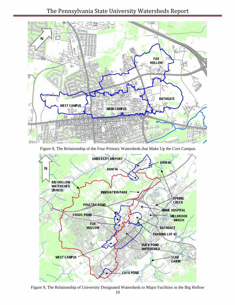
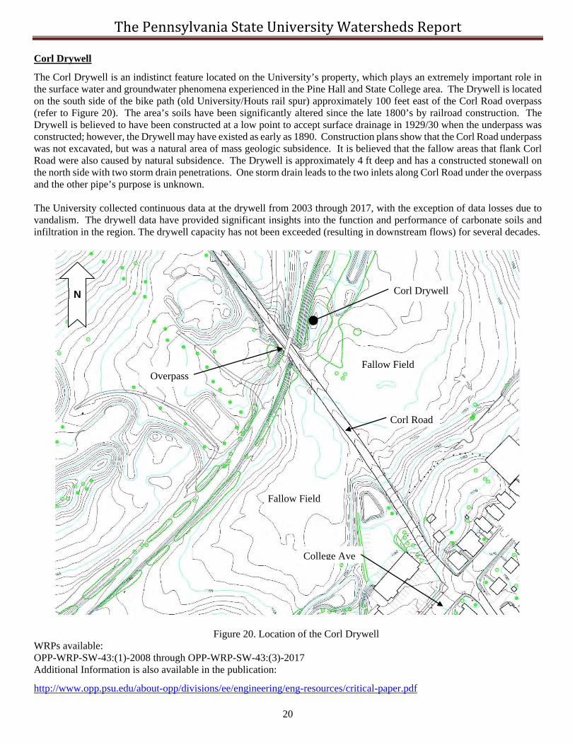
The majority of the developed portions of the University Park Campus are within one of four major drainage basins and several smaller drainage areas. The four major basins are: 1) the Fox Hollow Drainage Basin, 2) the Bathgate Dam Basin, 3) the Main Campus Basin, and 4) the West Campus Drainage Basin. The Fox Hollow and West Campus Drainage Basins are tributaries to the Big Hollow watershed, the Bathgate Dam Basin is tributary to Slab Cabin Run and the Main Campus Basin is tributary to Thompson Run. Other smaller University drainage basins include the Foods Building Detention Pond, the Parking Lot 43 Detention Pond, the Corl Drywell, and the Grad Circle Parking Bioswales. Additionally, the University Park Airport drains to two dams (Ponds 1A and 4A), which are tributary to the Big Hollow and Spring Creek watershed respectively. The Innovation Park complex drains to Spring Creek and the Big Hollow (refer to Figures 8 and 9).
Peak runoff rate control, volume control, and water quality control are conducted in the University Park area to varying degrees in each of the drainage basins. While minor structural stormwater management systems exist in each of the basins that were developed for specific land development projects, major systems have also been constructed to function at the basin scale. How quickly pollutants could reach a surface stream or the groundwater is highly dependent on the drainage basin. The following is a summary of background information on each drainage basin. Annual published data for many of the University drainage basins can be found in Water Resource Publications, which are available on request.

The Pennsylvania State University Watersheds Report
3
Figure 1, University Owned Lands in Area of University Park Campus

The Pennsylvania State University Watersheds Report
4
Figure 2, Major Watershed Divide near University Park Campus

The Pennsylvania State University Watersheds Report
5
Figure 3, Act 167 Stormwater Management Basins near University Park Campus
The Pennsylvania State University Watersheds Report
6
Figure 4, Minor Subwatersheds near University Park Campus

The Pennsylvania State University Watersheds Report
7
Figure 5, Subbasins of the Spring Creek Watershed
BUFFALO RUN LOWER SPRING CREEK
SLAB CABIN
BIG HOLLOW
CEDAR RUN
LOGAN BRANCH
UPPER SPRING CREEK
ROARING RUN
GALBRAITH GAP RUN

The Pennsylvania State University Watersheds Report
8
Figure 6, Spring Creek Watershed Surface Water and Groundwater Boundaries
SURFACE WATER BOUNDARY
GROUNDWATER BOUNDARY

The Pennsylvania State University Watersheds Report
9
Figure 7, Streams and Creeks near University Park Campus
Upper Slab Cabin
Thompson Run
Walnut Run
Millbrook Marsh
Spring Creek
Slab Cabin
University Property
Thompson Spring
Big Hollow N
The Pennsylvania State University Watersheds Report
10
Figure 8, The Relationship of the Four Primary Watersheds that Make Up the Core Campus
Figure 9, The Relationship of University Designated Watersheds to Major Facilities in the Big Hollow
BATHGATE
POULTRY POND
FOX HOLLOW
WEST CAMPUS
CATO POND
FOODS POND
DAM 1A
DAM 4A
PARKING LOT 43
SPRING CREEK
BIG HOLLOW WATERSHED (IN RED)
UNIVERSITY AIRPORT
MNMC HOSPITAL
MILLBROOK MARSH
INNOVATION PARK
BATHGATE
FOX HOLLOW
MAIN CAMPUS WEST CAMPUS
DUCK POND WATERSHED
SLAB CABIN
N
N

The Pennsylvania State University Watersheds Report
11
Fox Hollow Drainage Basin
The Fox Hollow Drainage Basin (FHDB) is located at University Park, Centre County, Pennsylvania and is a subbasin of the Big Hollow. The basin has a mix of several different land uses ranging from urban to agriculture with the outlet defined approximately 1,000 feet southeast of the overpass of U.S. 322. The FHDB surface drainage area is approximately 453.4 acres in size, of which currently 134.9 acres are impervious (29.8% impervious) and the basin is underlain 100% by carbonate geology. The FHDB does not have baseflow and surface runoff is primarily generated only by overland flow from impervious areas during rainfall events, with the exception of major snowmelt or rain on frozen ground conditions. The basin outlet was selected because it is the farthest downstream point where surface water can be controlled by the University prior to reaching the Big Hollow drainageway, which contains Penn State’s primary potable well fields.
In the early 1960s, the FHDB was primarily in agricultural use and had a distinct main drainageway that only contained four small culvert crossings. By the 1970s over 6,500 feet of the drainageway were filled in and replaced with storm drainpipes. By the 1980s drainage problems existed in the areas of the former drainageway. The last remaining portions of the drainageway exist at the Mitchell Tract, site of the Penn State Arboretum, and at the pasture where the experimental low head weirs are located. Today there are over 110,000 feet of storm drains within the FHDB. Small undisturbed drainageways in the region are almost always influent streams that play a significant role on protecting water quality and recharging the aquifer.
The University has instituted the use of stormwater BMPs such as green roofs, bio-infiltration systems, disconnection of impervious areas, and the protection of major natural recharge areas in the Basin. The use of natural and passive systems is preferred due to surficial sinkhole and water quality concerns and the failure of two porous pavement systems at the University in recent years. Figure 10 shows the location of the major recharge areas, water quality facilities, and surface and subsurface detention areas within the basin. In addition, numerous additional smaller facilities (constructed for single land development projects) are located throughout the basin.
Figure 10, The Fox Hollow Drainage Basin and Significant Stormwater Facilities
WRPs available: OPP-WRP-SW-FH:(1)-2005 through OPP-WRP-SW-FH:(8)-2018
N
Recharge Areas
Water Quality Treatment A
Recharge Areas
Surface and Subsurface Detention
Surface Drainage Basin 452.9 acre
Basin Outlet (v-notch)

The Pennsylvania State University Watersheds Report
12
Main Campus Drainage Basin
The Main Campus Drainage Basin cannot be separated easily from the larger Duck Pond watershed. The Duck Pond is owned by the University and is located near the Centre Furnace just south of College Avenue in the Borough of State College (refer to Figure 11). The Duck Pond has a contributing drainage area of approximately 843.6 acres (1.32 sq mi) of which approximately 50% is impervious. Historically, the duck pond drainage area to the downstream outfall has been considered 867 acres, but this value includes the drainage area tributary to the Thompson Run. The imperviousness in the drainage basin is highly connected and the Borough and the University own the storm drain systems. The watershed area is comprised of approximately 51% of University Lands and 49% of Urban and residential areas of the Borough. Three main storm drains (72”, 66”, and 48” CMPs) discharge into a drainage swale approximately 1200 ft above the Duck Pond. The duck pond does not have baseflow; however, a portion of the Thompson Spring flow is routed to the pond so that it does not become stagnant. A map of the Main Campus Drainage Area can be seen in Figure 11. Figure 12 shows the Main Campus Drainage Area compared to the total drainage area to the Duck Pond. The relationship between the Duck Pond and the Thompson Spring, Thompson Run, and the drainage swale can be seen in Figure 13. The Duck Pond is actually a Class 4 regulatory dam and is permitted by the Department of Environmental Protection. The Pond’s principal spillway is a two-stage concrete Ogee spillway. Prior to reaching the maximum design stage on the Ogee crest, water also can pass through the service road driveway, which has a trapezoidal section cut into the dam and flows can also overtop to the Thompson Spring channel. The resulting stage/discharge rating curve is complex and was developed using the US Army Corps of Engineer’s HEC-RAS model. Continuous stage/storage data have been collected at the pond since January 2007 at 5-minute intervals.
Figure 11, Main Campus Drainage Basin
N Duck Pond
Drainage Area Boundary
Outfall

The Pennsylvania State University Watersheds Report
13
Figure 12, Duck Pond Drainage Basin Identified by Size of Storm Drain Pipe at WWTP
Figure 13, Relationship of Thompson Spring and the Duck Pond
WRPs available: Duck Pond: OPP-WRP-DM-DP:(1)-2007 through OPP-WRP-DM-DP:(4)-2014 Thompson Spring: OPP-WRP-SW-TS:(1)-2008 and OPP-WRP-SW-TS:(2)-2010 Thompson Run Watershed: OPP-WRP-SW-TR:2013
N
College Ave
Porter Road
Thompson Spring
Centre Furnace
Duck Pond
Thompson Run Storm Drains (inflow)
Drainage Ditch (Ephemeral)
Floating trash rack Duck Pond Spillway
Fresh water from spring to duck pond
N
Main Campus72”
Drainage Area Boundary
Borough 48”
Borough 66”
Duck Pond

The Pennsylvania State University Watersheds Report
14
West Campus Drainage Basin
The West Campus Pond was constructed in 1993 to account for Campus expansion west of Atherton Street. The pond is located south of West Park Avenue and along the old railroad bed in Ferguson Township and the Borough of State College (refer to Figure 14). Most of the drainage area is located within the Borough and the pond itself is on the Municipal boundary. The pond had a contributing drainage area of approximately 50 acres with approximately 18.4 acres (36%) of impervious area. Because of overdevelopment in the basin, the pond overtopped the berm three times between 2012 and 2016; and therefore, the University decided the pond needed to be rebuilt for the next major development, which is occurring in 2020 for the West Campus parking deck project. The pond is being significantly increased in size and will include a water quality forebay, but will still be lined. The pond was also sized for the West Campus Engineering Buildings 1 and 2. The pond discharges directly into the Big Hollow drainageway that goes through the University’s Water Resource Preservation (WRP) areas on the golf course, just above, and downstream of the Corl Drywell (flows do not go to the drywell). The pond serves two functions, to reduce peaks to the downstream infiltration area, and to remove antiskid material. All discharges from the pond are known to infiltrate in the drainageway prior to leaving the University’s property, except for the most extreme runoff events. The last known incidence of stormwater leaving the University’s property was during Hurricane Ivan in 2004. Continuous stage/storage data were collected between July 2007 and June 2019.
Figure 14, West Campus Pond Drainage Basin
WRPs available: OPP-WRP-SW-WC:(1)-2008 through OPP-WRP-SW-WC:(4)-2018
N
Big Hollow Drainageway (Ephemeral)
West Campus Pond
Drainage Area
PSU Golf Course
Corl Drywell
University Property Line
Pond Outfall

The Pennsylvania State University Watersheds Report
15
Bathgate Drainage Basin
The Bathgate Watershed is located at University Park, Centre County, Pennsylvania. The watershed boundary is defined by the Bathgate Dam, which is a regulated dam (D14-122) by the Pennsylvania Department of Environmental Protection (PaDEP) and has a drainage area of approximately 237 acres. The dam has a permanent pool with normal pool area of approximately 1 acre in size. The maximum storage capacity is approximately 74 ac-ft. The dam discharges to Slab Cabin Run/Thompson Run at Millbrook Marsh via a 66” reinforced concrete storm drain outfall pipe. The dam’s primary function is to control stormwater runoff including peak runoff rates (the 1 through 100-year events) and improve water quality. The dam was also designed to safely pass ½ of the probable maximum flood (PMF). Bathgate Dam is classified as a High Hazard (category 1), size class C structure by PaDEP.
The watershed is a mix of developed campus areas (Beaver Stadium, the Jordan Center, Holuba Hall, the Multisport
Indoor Complex, and parking areas), and open fields (refer to Figure 15). A large portion of the open fields are used six or seven times a year for football parking events. The Bathgate Dam is designed for a maximum impervious area of 95.9 acres and 2.5 acres of gravel. The Imperviousness and gravel in the watershed in 2020 is 92.3 acres. There are over 7.5 miles of storm drains in the Bathgate Watershed varying in size from 4 to 54 inches in diameter. These storm drains terminate near Porter Road and stormwater is conveyed to the dam via a 1,600-foot long concrete swale with an average slope of 4.8% that was reconstructed in 2014 following a sinkhole that destroyed approximately 200 feet of the swale. Runoff data have been continuously collected since 2006 to the current time.
Figure 15, The Bathgate Drainage Basin WRPs available: OPP-WRP-DM-BG:(1)-2007 through OPP-WRP-DM-BG:(4)-2010
N
Bathgate Dam
Surface Drainage Basin 236.6 acres
Dam Outfall
Millbrook Marsh

The Pennsylvania State University Watersheds Report
16
Airport Dam 1A Drainage Basin
The Airport Dam 1A was constructed in 1996/7 as part of the runway 6-24 expansion project. In 2006, the drainage area was significantly modified for the PA Air National Guard (PANG) Air Operations Squadron Training Facility. The dam is located on the south side of the airport in Benner Township (refer to Figure 16). Prior to the PANG site construction, the dam had a contributing drainage area of approximately 79.3 acres, which was increased to 120.1 acres following the development of the PANG site. When the dam was constructed it did not meet the normal criteria for being designed a regulated dam, the structure was classified as a dam by PADEP due to downstream existing residences. The impervious area to the dam following the PANG site construction will be 26.2 acres (22%) of imperviousness, a significant increase from the original 6.1 acres of imperviousness. The imperviousness is almost all connected via storm drain pipes and grass/rock lined conveyance swales. The dam (PaDEP permit # 14-121) is a 19 feet tall earthen structure classified as a C-2 High Hazard structure by PADEP. The dam was designed to meet the local municipal stormwater management ordinance, and the dam was also designed to pass the ½ PMF runoff event. The dam discharges to the Big Hollow ephemeral drainageway. Runoff is discharged from the dam via the spillway at the interior toe of slope that ties into a 36” RCP outflow pipe. Additionally, the dam has a 50’ wide earthen emergency spillway. During the precipitation event of 10/21/2016 a massive sinkhole opened inside the pond that was repaired in the fall of 2017; however, the dam is still unlined. On January 2nd 2007, the Office of Physical Plant (OPP) installed a pressure transducer on the dam’s low flow spillway and began collecting data at 5-minute intervals.
Figure 16, Airport Dam 1A Drainage Basin WRPs available: OPP-WRP-DM-1A:(1)-2007 through OPP-WRP-DM-1A:(2)-2008
N
Big Hollow
Drainage Area
Fox Hill Road
Airport
Dam 1A PANG Site
Dam Outfall

The Pennsylvania State University Watersheds Report
17
Airport Dam 4A Drainage Basin
The Airport Dam 4A was constructed in 1997 for future runway expansion projects and additional land development projects, and is located on the east side of the airport in Benner Township (refer to Figure 17). The dam was originally designed to have a contributing drainage area of approximately 306 acres with approximately 61.9 acres (20%) of impervious area. However, in 2013 the University discovered that almost 45 acres of the drainage area was neglected by the original design engineer in the area of the PTI test track. In 2014 the University provided this information to DEP Dam Safety and DEP determined the dam was still OK since the dam had previously been downgraded in hazard classification from C-2 high hazard to C-3. The original design accounted for 74.8 acres of future impervious area. The imperviousness is almost all connected via storm drainpipes and grass/rock lined conveyance swales. The dam (PaDEP permit # 14-123) is a 27.5 feet tall earthen structure classified as a C-3 structure by PaDEP. The dam was originally designed to meet the local municipal stormwater management ordinance, and was also designed to pass the ½ PMF runoff event (a common requirement for C-2 dams). A C-3 dam spillway capacity can be designed for between the 100-yr and ½ PMF event. The dam discharges approximately 3,000 feet upslope of Spring Creek along an unnamed tributary. During construction, numerous sinkholes occurred, ultimately resulting in the dam being structurally lined. The dam is a dry pond and has no baseflow; however, because of the liner, extended trickle flows occur due to the dewatering of the soils above the liner. Runoff is discharged from the dam via a low flow spillway at the interior toe of slope and a high flow spillway that both tie into a 36” RCP outflow pipe. Additionally, the dam has a 110’ wide earthen emergency spillway. On January 2nd 2007, the Office of Physical Plant (OPP) installed a pressure transducer on the dam’s low flow spillway and began collecting data at 5-minute intervals.
Figure 17, Airport Dam 4A Drainage Basin WRPs available: OPP-WRP-DM-4A:(1)-2007 through OPP-WRP-DM-4A:(2)-2008
N
Big Hollow Spring Creek
Drainage Area
Fox Hill Road
Airport
Dam 4A
Dam Outfall

The Pennsylvania State University Watersheds Report
18
Foods Pond Drainage Basin
The Foods Building Pond was originally constructed in 1988/9 exclusively for the Foods Building project and is located north of Park Avenue in College Township (refer to Figure 18). In 2014 the pond had a contributing drainage area of approximately 86.7 acres with approximately 30 acres (35%) of impervious area. The imperviousness is almost all disconnected and a storm drain system does not exist throughout the basin. The basin consists of approximately 10 acres of small buildings and approximately 20 acres of roads and parking areas, several of which are gravel. Several smaller stormwater management ponds have been constructed within the basin for small land development projects, because the pond was not sized initially for future development. The original pond was designed and constructed prior to the Spring Creek Act167 Plan; and therefore, the design discharges were considered high by today’s standards. The Pond’s principal and emergency spillways were combined in a single concrete weir outlet structure. Continuous stage/storage data have been collected at the pond since July 2007. After collecting rainfall and runoff data, the Office of Physical Plant redesigned the rectangular weir and installed a temporary stainless-steel weir over the opening in October 2009, which significantly reduced the discharges from the pond. Discharges have been reduced from 100 cfs to 54 cfs for a 10-year design event. The new v-notch weir was only temporary, because the eventual goal was to rebuild the entire outlet structure further reducing pond discharges. In 2015, the pond was moved slightly down the hill and increased in size to account for an additional 9 acres of future imperviousness and roadway conveyance systems are being constructed to prevent nuisance flooding.
Figure 18, Foods Building Pond Drainage Basin WRPs available: OPP-WRP-SW-FB:(1)-2008 through OPP-WRP-SW-FB:(2)-2012
N
Big Hollow
Foods Pond
Drainage Area
Park Ave
Pond Outfall

The Pennsylvania State University Watersheds Report
19
Parking Lot 43 Pond
The Parking Lot 43 Pond was constructed in 1995 as a traditional dry detention pond to account for a single parking lot because the lot was located directly upslope of the Centre Furnace and Thompson Run. The pond is located northwest of the intersection of College Ave and Porter Road and is located in College Township and the Borough of State College (refer to Figure 19). The pond has a contributing drainage area of approximately 11.2 acres with approximately 5.35 acres (48%) of impervious area. The imperviousness is fully connected by storm drains in the parking lot that discharge down a reno-mattress that conveys the runoff down to the pond bottom. Minor scour problems have occurred at the pond’s reno-mattress because of the high (28%) slope. In 2002, the pond was converted to an infiltration/water quality basin. In July of 2007, the Office of Physical Plant (OPP) began gaging the basin outflows and determined that the pond was infiltrating too well, in part due to the underlying bedrock conditions. On April 24th, 2009, OPP started a series of changes to reduce the infiltration of water into the pond floor. These studies and modifications are still ongoing; however, the pond rarely holds any water. The pond’s location on the hillslope was a result of construction issues. The original plan was for the pond to be located at the bottom of the slope in the clearing; however, the discovery of historical artifacts (building foundation) during construction necessitated the relocation. This same lower cleared area adjacent to Porter Road was also previously used as the University’s outdoor coal storage area prior to the 1970s.
Figure 19, Parking Lot 43 Pond Drainage Area WRPs available: OPP-WRP-SW-43:(1)-2009 through OPP-WRP-SW-43:(2)-2011
N
College Ave
Porter Road
Drainage Area
Pond Centre Furnace
Pond Outfall
Duck Pond
Thompson Run
Reno Mattress
The Pennsylvania State University Watersheds Report
20
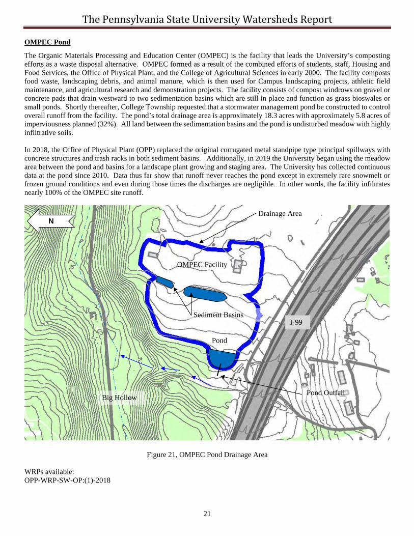
Corl Drywell
The Corl Drywell is an indistinct feature located on the University’s property, which plays an extremely important role in the surface water and groundwater phenomena experienced in the Pine Hall and State College area. The Drywell is located on the south side of the bike path (old University/Houts rail spur) approximately 100 feet east of the Corl Road overpass (refer to Figure 20). The area’s soils have been significantly altered since the late 1800’s by railroad construction. The Drywell is believed to have been constructed at a low point to accept surface drainage in 1929/30 when the underpass was constructed; however, the Drywell may have existed as early as 1890. Construction plans show that the Corl Road underpass was not excavated, but was a natural area of mass geologic subsidence. It is believed that the fallow areas that flank Corl Road were also caused by natural subsidence. The Drywell is approximately 4 ft deep and has a constructed stonewall on the north side with two storm drain penetrations. One storm drain leads to the two inlets along Corl Road under the overpass and the other pipe’s purpose is unknown. The University collected continuous data at the drywell from 2003 through 2017, with the exception of data losses due to vandalism. The drywell data have provided significant insights into the function and performance of carbonate soils and infiltration in the region. The drywell capacity has not been exceeded (resulting in downstream flows) for several decades.
Figure 20. Location of the Corl Drywell WRPs available: OPP-WRP-SW-43:(1)-2008 through OPP-WRP-SW-43:(3)-2017 Additional Information is also available in the publication:
http://www.opp.psu.edu/about-opp/divisions/ee/engineering/eng-resources/critical-paper.pdf
N Corl Drywell
Overpass
Corl Road
College Ave
Fallow Field
Fallow Field
The Pennsylvania State University Watersheds Report
21
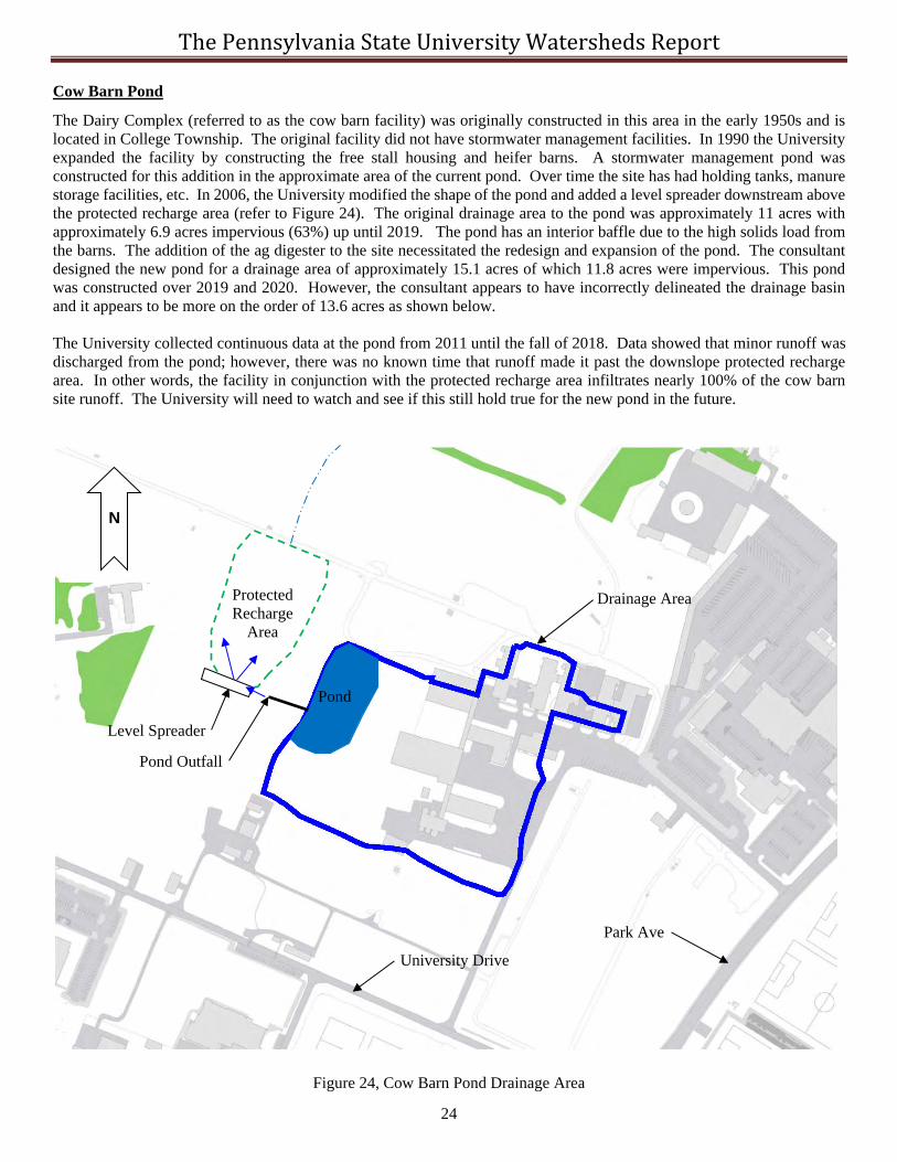
OMPEC Pond
The Organic Materials Processing and Education Center (OMPEC) is the facility that leads the University’s composting efforts as a waste disposal alternative. OMPEC formed as a result of the combined efforts of students, staff, Housing and Food Services, the Office of Physical Plant, and the College of Agricultural Sciences in early 2000. The facility composts food waste, landscaping debris, and animal manure, which is then used for Campus landscaping projects, athletic field maintenance, and agricultural research and demonstration projects. The facility consists of compost windrows on gravel or concrete pads that drain westward to two sedimentation basins which are still in place and function as grass bioswales or small ponds. Shortly thereafter, College Township requested that a stormwater management pond be constructed to control overall runoff from the facility. The pond’s total drainage area is approximately 18.3 acres with approximately 5.8 acres of imperviousness planned (32%). All land between the sedimentation basins and the pond is undisturbed meadow with highly infiltrative soils. In 2018, the Office of Physical Plant (OPP) replaced the original corrugated metal standpipe type principal spillways with concrete structures and trash racks in both sediment basins. Additionally, in 2019 the University began using the meadow area between the pond and basins for a landscape plant growing and staging area. The University has collected continuous data at the pond since 2010. Data thus far show that runoff never reaches the pond except in extremely rare snowmelt or frozen ground conditions and even during those times the discharges are negligible. In other words, the facility infiltrates nearly 100% of the OMPEC site runoff.
Figure 21, OMPEC Pond Drainage Area WRPs available: OPP-WRP-SW-OP:(1)-2018
N
Big Hollow
Sediment Basins
Drainage Area
Pond
I-99
Pond Outfall
OMPEC Facility

The Pennsylvania State University Watersheds Report
22
Poultry Pond
The poultry complex was moved to this location in the early 1990s having previously been located south of Curtin Road between University Drive and Bigler Road where the current athletic fields are located. The current site drains to the Big Hollow watershed. The pond was designed to control a drainage area of approximately 11 acres, of which 3.5 acres are considered impervious (32%). The Pond wraps around the perimeter as shown in Figure 22. The site has some storm drains but is mostly disconnected impervious area. The pond discharges to a gravel level spreader shared with the Big Hollow Landscape Facility’s pond, which then discharges across agricultural pastures. A small area of cattail plants have established within the pond. The University has collected continuous data at the pond since 2010. Data thus far show that runoff rarely is discharged from the pond except in extremely rare snowmelt or frozen ground conditions and even during those times the discharges are negligible. In other words the facility infiltrates nearly 100% of the poultry site runoff.
Figure 22, Poultry Pond Drainage Area
N
Big Hollow
Drainage Area
Pond
Tower Road
University Drive
Pond Outfall
Big Hollow

The Pennsylvania State University Watersheds Report
23
Big Hollow Landscape Pond
The Big Hollow Landscape facility was moved to this location in 2010 having previously been located in the Orchard Road area. The current site drains to the Big Hollow watershed. The pond was designed to control a drainage area of approximately 8.4 acres, of which 4.3 acres are considered impervious (51%). The initial construction had approximately 2.8 acres of imperviousness constructed and an additional future 1.5 acres of imperviousness were reserved. The Pond is located north of the site due to concerns for the University downslope potable water production wells, refer to Figure 22. Runoff is conveyed to the pond via a stormwater conveyance pipe that starts at a water quality inlet. This pipe travels under agricultural pastures. The pond discharges to a gravel level spreader shared with the Poultry Facility’s pond, which then discharges across agricultural pastures. Shortly after construction a surficial sinkhole developed in the pond (the pond is unlined). The sinkhole was repaired without lining the pond and the pond’s principal spillway was moved slightly north. Multiple shallow fracture traces were discovered during construction and another surficial sinkhole opened up on the north edge of the site during construction. There is a known natural closed depression on the site, which is believed to be linked to fracture traces on which one of the potable wells was developed. The University has collected continuous data at the pond since 2011. However, because of the sinkhole issues with the pond, OPP has yet to determine the pond’s general performance. The reserved imperviousness was originally allocated for a future greenhouse complex. However, in 2014 the site was designated for the new University Data Center Complex, which resulted in diverting all site runoff to the Foods Pond.
Figure 23, The Big Hollow Landscape Pond Drainage Area
N
Drainage Area Pond
Tower Road
University Drive
Pond Outfall
Site Stormwater Conveyance Pipe
Closed Depression
The Pennsylvania State University Watersheds Report
24
Cow Barn Pond
The Dairy Complex (referred to as the cow barn facility) was originally constructed in this area in the early 1950s and is located in College Township. The original facility did not have stormwater management facilities. In 1990 the University expanded the facility by constructing the free stall housing and heifer barns. A stormwater management pond was constructed for this addition in the approximate area of the current pond. Over time the site has had holding tanks, manure storage facilities, etc. In 2006, the University modified the shape of the pond and added a level spreader downstream above the protected recharge area (refer to Figure 24). The original drainage area to the pond was approximately 11 acres with approximately 6.9 acres impervious (63%) up until 2019. The pond has an interior baffle due to the high solids load from the barns. The addition of the ag digester to the site necessitated the redesign and expansion of the pond. The consultant designed the new pond for a drainage area of approximately 15.1 acres of which 11.8 acres were impervious. This pond was constructed over 2019 and 2020. However, the consultant appears to have incorrectly delineated the drainage basin and it appears to be more on the order of 13.6 acres as shown below. The University collected continuous data at the pond from 2011 until the fall of 2018. Data showed that minor runoff was discharged from the pond; however, there was no known time that runoff made it past the downslope protected recharge area. In other words, the facility in conjunction with the protected recharge area infiltrates nearly 100% of the cow barn site runoff. The University will need to watch and see if this still hold true for the new pond in the future.
Figure 24, Cow Barn Pond Drainage Area
N
Drainage Area
Park Ave
Level Spreader
Pond
University Drive
Protected Recharge
Area
Pond Outfall

The Pennsylvania State University Watersheds Report
25
Cato Pond Drainage Basin
The Cato Pond is located in Ferguson Township and was originally constructed by a private developer for an approximately 123-acre drainage area around the Cato Industrial Park. Unfortunately, the University later purchased a parcel in the park that resulted in the University’s ownership of the pond. The University currently owns approximately 22 acres (18%) of land tributary to the pond. In 2018 the University estimated that it owned approximately 11 acres of impervious area that drained to the pond; however, off site imperviousness owned by private parties and the Township drained approximately 34 acres of imperviousness to the pond. When originally constructed the pond’s principal spillway discharged to a fallow field on the downstream side of the pond. During the development of the fallow parcel in 1994, a new longer pipe was connected to the outfall and diverted to the north side of Bristol Avenue. The pipe that was installed was not in accordance with the approved design resulting in the pond no longer being able to safely pass the 100-year discharge. As a result, a pond redesign was conducted in 2003 and the University and the Township agreed that the next major development in the watershed would be required to fund this pond’s repair. The pond has had a history of sinkholes and the University has repaired multiple sinkholes in the pond. Because the pond’s discharges ultimately go to downstream sinkholes, the University has used rock filters and the pond is still unlined. In 2013 during an inspection of the pond it was found that the principal spillway was failing. It was later determined that the original contractor had reused a septic holding tank for the spillway. The University rebuilt the principal spillway in coordination with the Township. The University has collected data continuously at the pond since 2009.
Figure 25, Cato Pond Drainage Area
N
Drainage Area
Pond
Pond Outfall
West College Ave
Bristol Ave

The Pennsylvania State University Watersheds Report
26
The Big Hollow Watershed
The Big Hollow watershed is defined by PaDEP Chapter 93 as a Cold Water Fishery; however, local experts indicate that the Big Hollow has likely not had any surface runoff anywhere along its length for tens of thousands of years. The Big Hollow is an under drained valley formed in the Gatesburg Geology and has no springs or intermittent flows; and therefore, the Big Hollow is an ephemeral stream that only responds to precipitation events. Fortunately, the University owns a significant portion of the hollow starting below the McKee Street bike path. The University has placed the Big Hollow drainageway into its Water Resources Preservation land classification. Major sinkholes exist in the upper reaches including the radio park sinkhole. The Corl Drywell is also located in the headwaters.
The University’s primary potable well field lies within the Big Hollow watershed. As part of its wellhead protection efforts, the University instituted an extensive monitoring program since 2006 in the Big Hollow including eight surface water gaging stations. These gages show how the Big Hollow recharges surface runoff and that runoff making it past the University’s property along lower Big Hollow Road is rare.
Figure 26, The Big Hollow Watershed Surface Water Boundary
WRPs available: OPP-WRP-SW-BH:(1)-2008 through OPP-WRP-SW-BH:(2)-2010 and OPP-WRP-SR-BH6:2019
N
Surface Drainage Area
Spring Creek
Big Hollow Ephemeral Stream
Corl Drywell
Radio Park Sinkhole
Outlet
Millbrook Marsh
Big Hollow Ephemeral Stream

The Pennsylvania State University Watersheds Report
27
Shavers Creek Watershed
The University’s Shavers Creek property drains to Shavers and the Standing Stone Creeks (refer again to Figure 3). The most significant water feature in the area is Lake Perez located in Barree Township, Huntingdon County (refer to Figure 27). The lake is approximately 70 acres in size and resulted due to the construction of the Shavers Creek Dam in 1960-61. The dam is an earth filled structure 50ft high and 540ft long constructed by the Civil Engineering Department and is the largest dam owned by the University. In the late 1990’s the emergency spillway was found to be undermined and needed to be replaced. The new construction triggered higher design criteria. The spillway was repaired in 2001 in addition to articulated concrete block being installed along the downstream face to account for overtopping flows during a full PMF design storm. The dam’s contributing drainage area is 8.2 square miles and the resulting PMF required by the PA Department of Dam Safety was 28,000 cfs. The dam is currently a Size Class B, Category 1 (high hazard) dam. The dam was refilled in 2003 and shortly thereafter a boil was observed on the downstream toe. The University, in coordination with Dam Safety, began monitoring the boil. In 2007 an inverted filter was installed over the boil which resulted in the boil becoming unstable. Dam Safety requested that the University draw down the lake for safety reasons and the University started drawing down the lake in November 2007 but allowed the water to remain at lower levels while testing occurred. The dam was finally emptied by the summer of 2009. In March 2013, the University began a construction project to inject a series of grout curtains along the crest of the dam in addition to a large toe drain at the downstream bottom. Work was finished in the summer of 2014 and the dam began to be refilled. In the spring of 2015, the dam was once again in service. Operation of the Dam has been conveyed to the University Student Services Department. The University collects water surface elevation data at the spillway.
Figure 27. Shavers Creek Dam Watershed
N
Shavers Creek Dam
Watershed Boundary

The Pennsylvania State University Watersheds Report
28
The Test Track Drainage Areas The University in conjunction with the Pennsylvania Department of Transportation built the original test track in the early 1970s in Benner Township. The original project consisted of the track, an entrance drive, and 5 culverts (four under the track and one at the entrance) with no stormwater management facilities. The majority of the site drained to the intersection of Fox Hill and Rock Roads, which drains ultimately to Spring Creek via the Airport Dam 4A. The remainder of the site drains to unnamed tributaries of Buffalo Run. By 1990, the Township expressed concerns with water at the intersection due to small increases in imperviousness that occurred at the site resulting in the University constructing four ponds, the largest of which was Pond A with a drainage area of approximately 24 acres (refer to Figure 28). Pond A later had sinkhole problems and therefore was lined in 1994. Today there are a total of five (5) surface ponds at the facility. Multiple additional stormwater best management practices are included in the center area of the track that were constructed for the Engineering Department and other University research entities. These facilities are not shown on the figure below. The University collected runoff data at Pond A between 2010 and October 2018.
Figure 28. The Test Track Drainage Areas
N
Drainage Area (typ.) Pond A (5)
Pond D (1)
Pond C2 (2)
Pond B3 (3)
Pond B2 (4)
Rock Road
PSU Undeveloped Property
Flows to Airport Dam 4A

The Pennsylvania State University Watersheds Report
29
Innovation Park Drainage Basins Innovation Park is a 118 acre business park located at the University Park Campus north of I-99 in College Township, Centre County, Pa. Park development started in the 1990’s and today consists of the Penn Stater Conference Center Hotel, the Daybridge Child Development Center, the Lubert Building, the Outreach Building, the Material Research Institute Building, the Technology Center Building, the 103 Building, and the 310, 328, 329, 330, and 331 Buildings. The majority of the site drains north to the Big Hollow Watershed and a smaller area primarily around the Outreach Building, the Material Research Institute Building, and the Technology Center Building drains through Pennsylvania Department of Transportation facilities to Spring Creek. There are currently four ponds on University property (A, B, C, and D) at the park. Also, of stormwater importance is a water quality forebay in Pond A and a concrete v-notch weir or Low Head Weir (LHW) constructed for the 329 Building (refer to Figure 29). The 329 Building originally proposed a new pond below Pond A, but was later directed into Pond A because of the downstream sinkhole concerns. The 331 Building site has two subsurface detention facilities that discharge into the LHW backwater area. Not all the buildings or stormwater facilities are owned by the University and maintenance agreements exist for the entire park. Pond A drains the majority of the Park and has a drainage area approximately equal to 42 acres. Pond C, which has a drainage area equal to approximately 14 acres, and the area that drains to PennDOT’s Pond 6 both drain eventually to Spring Creek. Pond C was originally demolished by PennDOT during the construction of I99 and was reconstructed in 2017 as an infiltration basin for the 310 Building. A stormwater management master plan was developed in 2011 for the remaining park build-out which includes additional stormwater facilities to be constructed offsite downstream of the LHW if required.
Figure 29. The Innovation Park Drainage Basins
WRPs available: OPP-WRP-SW-IP:(1)-2013 through OPP-WRP-SW-IP:(4)-2020
N
Watershed Boundary (typ)
I99
To Pond A Forebay
To PennDOT Pond 6 Pond C
Pond B
Pond D
329 Building To Pond A
Undetained
Original Area to Pond A
Low Head Weir (LHW)
Pond A
331 Building To LHW

The Pennsylvania State University Watersheds Report
30
Rock Springs Area The Russell E. Larson Agricultural Research Center at Rock Springs, about 10 miles southwest of University Park comprises 2,000 acres of land and is referred to as Rock Springs. The University’s Rock Springs properties are primarily located in Ferguson Township along either side of State Route 45 (refer to Figure 30). The property is comprised of four separate research farms (for Agronomy, Entomology, Horticulture, and Plant Pathology) and the site of the annual Penn State Ag Progress Days, which is held each August. Surface runoff from the farm areas is rare and large ponds exist on site in addition to large protected sinkholes that provide regional groundwater recharge from the mountain slope water. Minor stormwater demonstration features exist across the site. The perennial section of the tributary leaving in close proximity to the University’s property originates from a spring on the Imbt property, which is surrounded on three sides by the University’s property. While Spruce Creek is defined by the PA Department of Environmental Protection as impaired several thousand feet downstream, there are no perennial or intermittent streams on the University’s property, except below the Imbt spring.
Figure 30. The Rock Springs Drainage Area
N
Drainage Divides (typ.)
Rock Springs Property
Imbt Property Spring

The Pennsylvania State University Watersheds Report
31
Orchard Road Drainage Basin The Orchard Road Drainage Basin is approximately 190 acres in size and is located within College Township and drains to Slab Cabin Run in Millbrook Marsh. The basin consists primarily of University owned open space and pastures that are used for event parking, Park Avenue, a portion of the Mount Nittany Medical Center parking areas, and private residential lots near the outlet of the basin. The University built the Park Ave Low Head Weir (LHW) in 2012 to account for fill that was placed on the north side of Park Avenue. The drainage area to the LHW is approximately 66 acres and the eastern half of Park Avenue and other University impervious areas drain to the LHW. The University constructed the Orchard Road solar field in 2019 located on the north side of orchard road on the slope. Three small infiltration berms were constructed for the solar field. There are no additional stormwater management facilities within the basin. Persistent flooding occurred in the past because Orchard Road’s alignment was constructed directly over the drainageway for the lower western half of the road. Additionally, an undersized conveyance system owned by the Township existed near the intersection of Puddintown Road. This resulted in a condition where water flowed down Orchard Road to Puddintown Road during larger runoff events or snowmelt conditions. In 2017 as part of a bicycle lane project, the Township constructed a new swale through an existing topographic saddle as shown on Figure 31. This swale and storm drain system is intended to divert water off the road and be discharged to another culvert under Puddintown Road. Flows in excess of this new system’s capacity are intended to flow down the lower section of Orchard Road through the residential area similar to in the past.
Figure 31, The Orchard Road Drainage Basin
N
Drainage Divides (typ.)
2017 Swale
Millbrook Marsh
Low Head Weir
Orchard Road
Park Ave
Solar Field with three infiltration berms
The Pennsylvania State University Watersheds Report
32
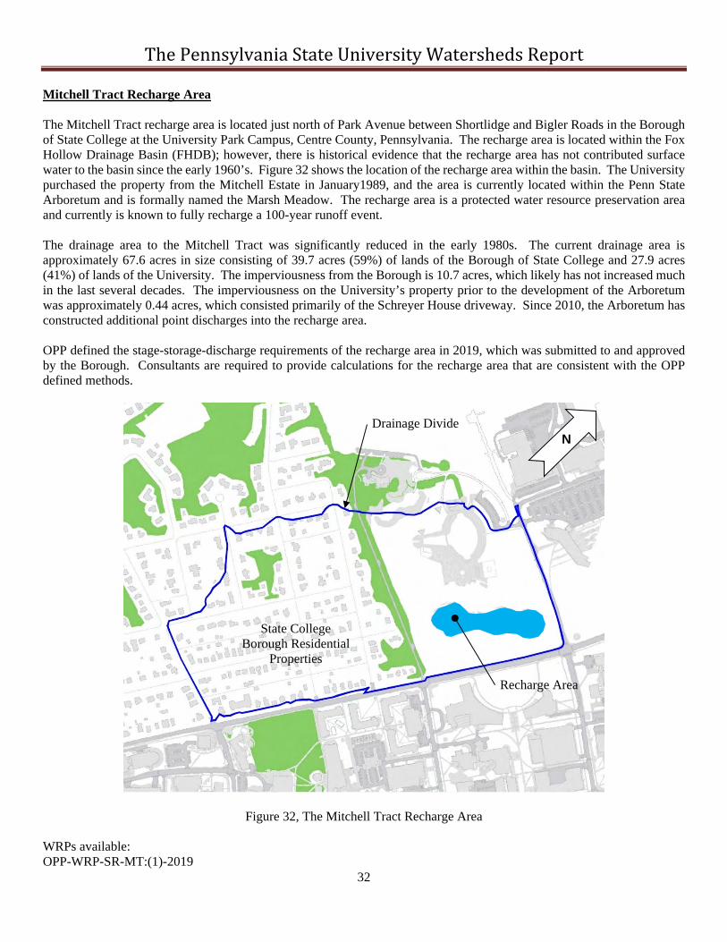
Mitchell Tract Recharge Area The Mitchell Tract recharge area is located just north of Park Avenue between Shortlidge and Bigler Roads in the Borough of State College at the University Park Campus, Centre County, Pennsylvania. The recharge area is located within the Fox Hollow Drainage Basin (FHDB); however, there is historical evidence that the recharge area has not contributed surface water to the basin since the early 1960’s. Figure 32 shows the location of the recharge area within the basin. The University purchased the property from the Mitchell Estate in January1989, and the area is currently located within the Penn State Arboretum and is formally named the Marsh Meadow. The recharge area is a protected water resource preservation area and currently is known to fully recharge a 100-year runoff event. The drainage area to the Mitchell Tract was significantly reduced in the early 1980s. The current drainage area is approximately 67.6 acres in size consisting of 39.7 acres (59%) of lands of the Borough of State College and 27.9 acres (41%) of lands of the University. The imperviousness from the Borough is 10.7 acres, which likely has not increased much in the last several decades. The imperviousness on the University’s property prior to the development of the Arboretum was approximately 0.44 acres, which consisted primarily of the Schreyer House driveway. Since 2010, the Arboretum has constructed additional point discharges into the recharge area. OPP defined the stage-storage-discharge requirements of the recharge area in 2019, which was submitted to and approved by the Borough. Consultants are required to provide calculations for the recharge area that are consistent with the OPP defined methods.
Figure 32, The Mitchell Tract Recharge Area WRPs available: OPP-WRP-SR-MT:(1)-2019
N Drainage Divide
Recharge Area
State College Borough Residential
Properties

The Pennsylvania State University Watersheds Report
33
Field Maintenance Building Pond The Field Maintenance Building (FMB) pond was constructed for the FMB in 2000 and is located within the larger Foods Pond drainage basin. The pond sits perpendicular to Big Hollow Road between the FMB and the Hazmat Storage Building and is a small feature that can be mistaken as a swale. The original drainage area to the pond was designed to be 4.65 acres. At an unknown later date, a roof leader from the Hazmat building was diverted into the pond. This building was never originally accounted for in the drainage basin. Additionally, in 2003 when the construction of the new Blue Band Building occurred, the civil engineer for the project wrote that the FMB pond was designed for this new building, which was not correct; however, they directed runoff into the FMB pond nonetheless. The result was that the drainage area to the FMB pond increased to approximately 6.65 acres between 2003 and 2019. The FMB facility also has a specialized wash rack and an oil water separator for the onsite fueling station. In 2019, because of problems with uncontrolled runoff flowing through the FMB site, OPP designed and constructed a cutoff system to divert a portion of the Procurement Services parking lot to the new Big Hollow Road stormwater system and away from the pond. This resulted in reducing the pond’s drainage area to approximately 4.97 acres after 2019. The current drainage area can be seen in Figure 33. While the pond had a much larger than intended drainage area for 16 years, the pond did not overtop or appear to be in danger of failing. OPP began collecting data from 2011 until the current time.
Figure 33, The Field Maintenance Building Pond Drainage Area
N
Drainage Area
FMB Pond

The Pennsylvania State University Watersheds Report
34
Centralized Biological Lab Pond The Centralized Biological Lab (CBL) Pond was created for the parking lot that sits downslope of the CBL building. This parking lot was constructed in 2006 as a replacement for the Lot 83 N parking lot that was being disturbed by the Dickinson Law School building. Part of the Grad Circle Housing conversion to a parking lot was done at the same time and runoff from an approximately 3.61-acre area (2.0 acres for CBL and 1.61 acres for the Grad Circle) was diverted to the Bathgate Dam. Stormwater computations were therefore done for the diversion of runoff to the dam. The CBL pond had an original design drainage area of 4.9 acres with 3.88 acres imperviousness. Today the pond’s contributing drainage area appears to be approximately 5.3 acres. The site of the pond was selected because it appeared to be an undisturbed area with high infiltration capacity. When the pond was constructed the pond’s floor area was fenced off to limit compaction and only the area of the berm was compacted and disturbed. The CBL pond is somewhat unusual in that it has no noticeable principal spillway. Discharge from the pond is controlled through an inlet that sits in the bottom of the pond. The original design called for a 12” stainless steel orifice plate over the 15” outlet pipe; however, the orifice plate was never installed. Nonetheless, while OPP has never installed any gaging in the pond, observations indicate water rarely reaches the inlet or floods the pond except when inlet protection is installed for projects. One project that occurred in the last decade (approximately 2012) that disturbed part of the pond was the East Steam Plant project that installed a shallow tunnel through the pond’s western berm. The project resulted in also partially crushing the 15” HDPE outlet pipe from the pipe. This pipe repair has been identified in OPP’s list of required repairs.
Figure 34, The Centralized Biological Lab Building Pond Drainage Area
N
Drainage Area
CBL Pond

The Pennsylvania State University Watersheds Report
35
Softball Field Pond The Softball Field pond has a long history but was never actually constructed as a stormwater pond. It was first identified as a functioning pond by a consultant in 2002 and since that time it has been considered an unregulated stormwater facility. The pond is located on the SW corner of the intersection of Park Ave and University Drive. The pond is approximately at the original grade of the Fox Hollow drainageway that was filled in downstream for the new Beaver Stadium and baseball field in the 1960s. The pond was created by the extension of University Drive to Park Avenue, which installed a culvert under the road and effectively dammed up the flow. Today, the control of the discharge from the pond is a 48” RCP at the concrete headwall. Flows travel to the headwall via stabilized swales. The 48” then constricts down to a 42” CMP that runs under the current soccer fields for 1,200 ft at a flat grade resulting in creating a friction control condition that dictates the pond’s stage-discharge function. The pond’s contributing drainage area is approximately 90 acres as seen in Figure 35. The site is believed to always have been the original softball field location starting around 1965. As the University continued to develop upslope, the field frequently had wetness problems and several times was almost completely under water. OPP staff indicated that during the floods of 1996, the field was completely under water. In 2002, it was recommended to move the softball field up the slope to higher ground and allow the low area to function as a regional pond. The softball field was moved in 2010; however, because of budget limitations, the current softball field was not raised to a higher recommended elevation. Therefore, as Campus development continues, the risk of flooding to the current field continues to increase. Since the field was moved, flooding has already reached the outfield running track elevation. On November 2010 OPP installed a 12” high restrictor plate over the 48” RCP. The restrictor plate was increased in height to 1.73 feet in August 2012 in response to additional development upslope. The restrictor plate has hinges on it that allows it to be raised out of the way if rain is expected to occur over a football game. The reason is football parking occurs in the low area of the pond and the restrictor plate is designed to flood the low area immediately. The restrictor plate also traps debris at the headwall where the utility crews can vacuum them up prior to entering downstream storm drains. Data have been collected at the softball field headwall since 2009.
Figure 35. The Softball Field Pond Drainage Area
N
Drainage Area
Softball Pond
Outfall Pipe

The Pennsylvania State University Watersheds Report
36
Technology Support Building Pond The Technology Support Building (TSB) pond was originally constructed by a private developer (HRG Singer) in 1985 as part of a property expansion. The University purchased several parcels including the one the pond sits on around 2015. The pond is located on the west side of Science Park Road and sits back from the roadway due to being separated by another driveway and parcel. The pond was designed originally for approximately 35 acres; however, today the drainage area appears to be approximately 39 acres in size (refer to Figure 36). The pond controls runoff from the University property acquisitions in addition to an adjacent building owned by Raytheon and others, and part of Science Park Road. The pond ultimately discharges to the Gill Field sinkhole maintained by Ferguson Township. The pond has a stand of cattails immediately below the largest inflow pipe from the site. In 2019, OPP was notified about a sinkhole in the pond. A few months later in the fall, seven sinkholes had opened inside the pond that covered an area approximately 50 ft x 100 ft, which are suspected to be one large feature. Work to repair the sinkholes is planned to occur in 2020. The pond is currently unlined.
Figure 36, The Technology Support Building Pond Drainage Area
N
Drainage Area
TSB Pond

The Pennsylvania State University Watersheds Report
37
Low Head Weirs Low Head Weirs (LHW) are not known to exist anywhere other than at the University Park Campus. They were first pioneered by the University in 2003 in the Fox Hollow Drainage Basin. LHWs mimic the function of closed depressional areas in karstic areas and are constructed in natural topographic draws with undisturbed insitu soils above and below the weirs. The University currently has nine (9) LHWs on campus. The drainage areas to seven of the LHWs can be seen in Figure 37. The drainage areas for two (Katz and the Foods addition) are not shown because they have complex drainage areas where part of the flow is stripped off through the use of a diversion structure. The weirs are essentially berms similar to a dam with the exception that the maximum ponding depth is limited to approximately 2.5 feet deep before they overtop the berm’s spillway. Until reaching the spillway depth, all runoff into the LHW must be infiltrated or evapotranspire, with the exception of the Fox Hollow LHW B, which has a small 6” pipe under the berm that allows some runoff to reach LHW A just downstream. All low head weirs are constructed with impervious abutments and extremely limited work zones for the contractors. Small pipes are run under the berm to allow for draining if required; however, all of these are plugged except for the aforementioned FH LHW B. The backwater areas of the LHWs are protected from development or disturbance. Additionally, the University has three other areas that function similar to low head weirs but have roads that act as the weirs. These are the Weily Road, Cow Barn, and Orchard Rd closed depressions. Overflow devices are located such that they only function immediately prior to the roadway’s overtopping.
Figure 37, Low Head Weir Drainage Areas
N
Drainage Area (typ)

The Pennsylvania State University Watersheds Report
38
Subsurface Detention Facilities
The University owns 43 subsurface detention facilities at the University Park Campus. The approximate drainage areas to the facilities can be seen in Figure 38. The facilities are located in three of the major University drainage basins; Fox Hollow, Main Campus and West Campus and all are located within the Borough of State College or College Township. The sizes vary based on drainage area with most being constructed for single buildings or small developed areas. The first facility was constructed in 1987 for Academic Projects building expansion. The largest single unit, the SARNI subsurface facility, has 3.2 ac-ft of storage and was designed for 16.5 acres of development associated along Bigler Road and the Pegula Ice Arena. The total combined storage capacity of the 43 facilities is approximately 12.8 ac-ft. All subsurface detention units at the University are simply designed for peak rate runoff control and trash removal. None of the facilities are designed to infiltrate water due to surficial sinkhole related issues. The materials used for the current units include fiberglass, high density polyurethane (HDPE), corrugated metal pipe (CMP), and reinforced concrete pipe (RCP). Due to past findings and operational considerations, all new units are required to be constructed from RCP. Several of the older subsurface detention units were designed to have little, if any, effect on peak runoff rates including the Lasch Building, White Building, Career Services, and Eisenhower Deck facilities. Therefore, OPP started a data collection program in 2011 to determine how well the units functioned and if changes could be made to them to enhance their performance. Two facilities, Life Sciences and the East View Terrace facilities have been replaced in the last few years due to structural issues. For specific information on the subsurface facilities or their drainage areas, contact OPP Engineering Services.
Figure 38, The Drainage Areas to the Subsurface Detention Facilities in the Core Campus Area
N
Subsurface Detention Facility Drainage Area (typ)

The Pennsylvania State University Watersheds Report
39
Stream Segments on University Property The University’s property in the Centre Region includes over 2.7 miles of perennial streams. The properties include 4,930 ft of Spring Creek at two sites, 4,900 ft of Slab Cabin Run at three sites, 2,400 ft of Thompson Run at two sites, 1,600 ft of Spruce Creek at one site, and 500 ft of Halfmoon Valley Creek at one site. The stream sites can be seen approximately on Figure 39. These stream segments, while important to protect, can potentially also be used for research and/or teaching purposes. These stream lengths do not include intermittent or ephemeral stream segments. The University also owns over 3.4 miles of the main stem of the Big Hollow, which is legally defined as an ephemeral channel. Additionally, the University owns large segments of streams in Huntingdon County including Shavers Creek, Spruce Creek and Herod Run.
Figure 39, Overall Plan of Streams Owned by the University in the Centre Region
N