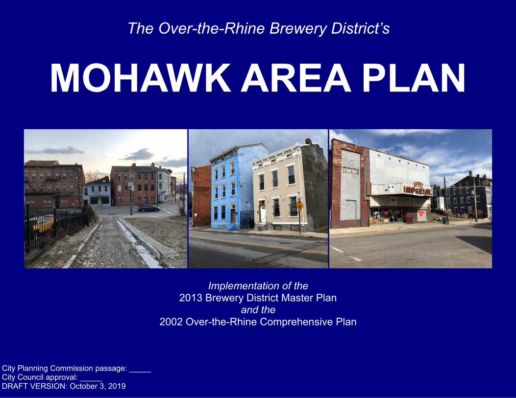
The Over-the-Rhine Brewery District’s MOHAWK AREA PLAN
48
1 The Over-the-Rhine Brewery District’s MOHAWK AREA PLAN Implementation of the 2013 Brewery District Master Plan and the 2002 Over-the-Rhine Comprehensive Plan City Planning Commission passage: _____ City Council approval: _____ DRAFT VERSION: October 3, 2019
Transcript of The Over-the-Rhine Brewery District’s MOHAWK AREA PLAN
1
The Over-the-Rhine Brewery District’s
MOHAWK AREA PLAN
Implementation of the 2013 Brewery District Master Plan
and the 2002 Over-the-Rhine Comprehensive Plan
City Planning Commission passage: _____ City Council approval: _____ DRAFT VERSION: October 3, 2019

2
(This page is intentionally left blank;
Cover Photos: John Walter and Deb Kittner Johnson)

3
Table of Contents Acknowledgements ........................... 5 Introduction ....................................... 7 Existing Conditions ........................... 11
Demographics ........................................ 12 Parks ...................................................... 13 Zoning .................................................... 14 Land Use ................................................ 16 Historic Districts ...................................... 18 Hillside Districts ...................................... 20 Transportation ........................................ 22 Economic Incentives .............................. 24 City-Owned Properties ........................... 26
Process: 2016-2019 .......................... 27 The Future of Mohawk ...................... 29 Vision ................................................ 31
Connectivity ............................................ 32 Economic Development ......................... 34 General Improvements ........................... 36 Housing .................................................. 38 Big Ideas and Challenges ...................... 40
Prioritization ...................................... 43
Photos: John Walter

4
(This page is intentionally left blank)
5
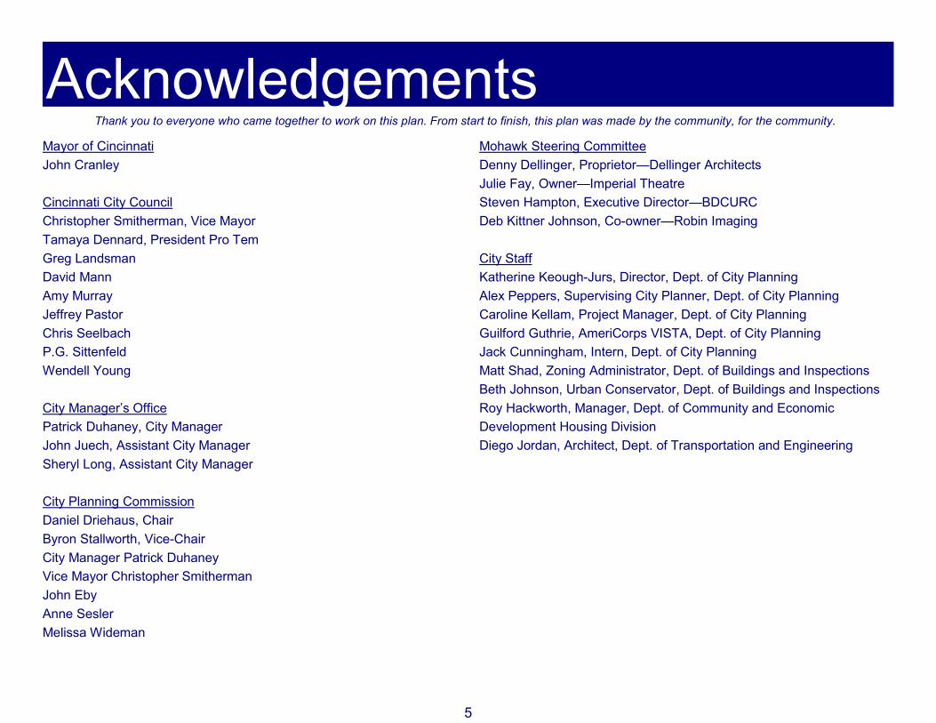
Acknowledgements Thank you to everyone who came together to work on this plan. From start to finish, this plan was made by the community, for the community.
Mayor of Cincinnati John Cranley Cincinnati City Council Christopher Smitherman, Vice Mayor Tamaya Dennard, President Pro Tem Greg Landsman David Mann Amy Murray Jeffrey Pastor Chris Seelbach P.G. Sittenfeld Wendell Young City Manager’s Office Patrick Duhaney, City Manager John Juech, Assistant City Manager Sheryl Long, Assistant City Manager City Planning Commission Daniel Driehaus, Chair Byron Stallworth, Vice-Chair City Manager Patrick Duhaney Vice Mayor Christopher Smitherman John Eby Anne Sesler Melissa Wideman
Mohawk Steering Committee Denny Dellinger, Proprietor—Dellinger Architects Julie Fay, Owner—Imperial Theatre Steven Hampton, Executive Director—BDCURC Deb Kittner Johnson, Co-owner—Robin Imaging City Staff Katherine Keough-Jurs, Director, Dept. of City Planning Alex Peppers, Supervising City Planner, Dept. of City Planning Caroline Kellam, Project Manager, Dept. of City Planning Guilford Guthrie, AmeriCorps VISTA, Dept. of City Planning Jack Cunningham, Intern, Dept. of City Planning Matt Shad, Zoning Administrator, Dept. of Buildings and Inspections Beth Johnson, Urban Conservator, Dept. of Buildings and Inspections Roy Hackworth, Manager, Dept. of Community and Economic Development Housing Division Diego Jordan, Architect, Dept. of Transportation and Engineering
6
The Mohawk Community Hubert Allen Nellie Allen Dan Bascone Daniella Beltran Rory Benson David Berger Fred Berger Brent Bielinski David Bird John Blatchford Anthony Bradford Brian Channel Shawn Charton Jerry Coleman Mor Diallo Fred Ellenberger Lawrence F. Todd Funhhauser Tim Haines Peter Hames Doug Hart Lee Hay Michele Hobbs David Holthaus Susan House Ryan Hunter Melvin Jackson Matt Jacob Annabelle Johnson Bill Johnson Cade Johnson Marilyn Johnson Kate Kotschevar Alan Krichavsky Fred Lane Ted Love Cliff Meyer Donna Meyer Mick Meyer Josh Mrvelj Shane Neuringer
Cody Ossenbeck Josh Paino Jason Pastor Guy Peters Shawn Pfeil Stephanie Phillips Cathy Rafales Harold Schuck Stuart Schulman Brent Schwas Rona Shannon Rod Sidley Elisabeth Spinner Otis Stevens Tiffany Stewart Lisa Storie Greg Szumlay Byron Thomas Mike Uhlenhake David Vorherr John Walter Tom Walter Deqah Wetzel Sam Wyatt Prisbet Yanes DAK Plan Photos Deb Johnson, Robin Imaging John Walter Philippus United Church of Christ City Planning Staff *Participation in the process does not signify agreement with all elements of the plan.

7
Introduction History The Over-the-Rhine (OTR) neighborhood is located in the heart of Cincinnati’s urban core. Just north of the Central Business District, OTR is also bordered by West End to the West, Clifton Heights and Mt. Auburn to the North, and Mt. Adams to the East. Within the OTR neighborhood is the historic Brewery District. The Brewery District boundaries lie roughly within northern OTR, and the district itself is bordered by Liberty Street to the South, Central Parkway to the West, McMicken Avenue to the Northeast, and the Clifton Heights hillside to the North. Furthermore, within the Brewery District lies the Mohawk area. The Mohawk area of the Over-the-Rhine neighborhood is a narrow corridor surrounding McMicken Avenue between Vine Street and McMillan Street. Mohawk Street runs parallel to McMicken Avenue, and Mohawk Place connects Central Parkway to McMicken. Mohawk, once a village along Hamilton Road (now known as McMicken), was established in 1792 along a trail to Hamilton, Ohio. As the Miami & Erie Canal was constructed in the 1820’s, Mohawk grew along the canal and became an important industrial center. Mohawk’s businesses used the canal to transport goods north towards Toledo and Lake Erie, and south towards the Ohio River. Mohawk’s industrial history included metalworking, blacksmithing, leather tanning, slaughterhouses, tin shops, bakeries, and brewing.
As a result of Mohawk’s industrial history and German heritage, the majority of the existing structures in Mohawk were built in the mid- to late-1800’s. Architectural styles found in Mohawk include: Greek Revival, Italianate, Second Empire, and Rundbogenstil, a type of Romanesque Revival.

8
Background and Previous Plans Since the beginning of the 21st century, the Over-the-Rhine Comprehensive Plan (2002) and the Brewery District Master Plan (2013) have outlined Cincinnati’s dedication to revitalizing this historic neighborhood. In 2002, Cincinnati City Council approved the Over-the-Rhine Comprehensive Plan. Within the plan, the Mohawk area was defined as the area north of Liberty along McMicken Avenue set at the base of the hillside. Mohawk was described as a Residential/Commercial Mixed-Use area with a mixture of one- and two-family units with some first floor commercial uses and some industrial uses. Throughout Mohawk there were vacant and underutilized parcels that were identified as potential new infill housing or redevelopment for other commercial or residential uses. The Over-the-Rhine Comprehensive Plan recommended several priority goals in the Mohawk area. One of these goals was to designate a local historic district within the Mohawk Area, which was accomplished in 2018. (More details on these historic districts can be found on page 18.)
The plan also sought to rehabilitate or reconstruct multi-family rental units with a mixture of affordable and market rate. The Mohawk area was also identified as having potential for loft style housing and office uses, especially in the larger industrial buildings. For example, structures that once contained breweries and food processing plants could be adaptively reused for housing and commercial uses. The Over-the-Rhine Comprehensive Plan also encouraged improvements to the Hanna Recreation area and creation of an Over-the-Rhine gateway at the intersection of West Clifton, Vine, and Mulberry near West McMicken Avenue.
9
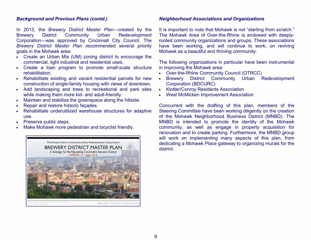
Background and Previous Plans (contd.) In 2013, the Brewery District Master Plan—created by the Brewery District Community Urban Redevelopment Corporation—was approved by Cincinnati City Council. The Brewery District Master Plan recommended several priority goals in the Mohawk area: • Create an Urban Mix (UM) zoning district to encourage the
commercial, light industrial and residential uses. • Create a loan program to promote small-scale structure
rehabilitation. • Rehabilitate existing and vacant residential parcels for new
construction of single-family housing with views of downtown. • Add landscaping and trees to recreational and park sites
while making them more kid- and adult-friendly. • Maintain and stabilize the greenspace along the hillside. • Repair and restore historic façades. • Rehabilitate underutilized warehouse structures for adaptive
use. • Preserve public steps. • Make Mohawk more pedestrian and bicyclist friendly.
Neighborhood Associations and Organizations It is important to note that Mohawk is not “starting from scratch.” The Mohawk Area of Over-the-Rhine is endowed with deeply-rooted community organizations and groups. These associations have been working, and will continue to work, on reviving Mohawk as a beautiful and thriving community. The following organizations in particular have been instrumental in improving the Mohawk area: • Over-the-Rhine Community Council (OTRCC) • Brewery District Community Urban Redevelopment
Corporation (BDCURC) • Klotter/Conroy Residents Association • West McMicken Improvement Association Concurrent with the drafting of this plan, members of the Steering Committee have been working diligently on the creation of the Mohawk Neighborhood Business District (MNBD). The MNBD is intended to promote the identity of the Mohawk community, as well as engage in property acquisition for renovation and to create parking. Furthermore, the MNBD group will work on implementing many aspects of this plan, from dedicating a Mohawk Place gateway to organizing murals for the district.

10
(This page is intentionally left blank)

11
Existing Conditions
Demographics ................................... 12 Parks ................................................. 13 Zoning ............................................... 14 Land Use .......................................... 16 Historic Districts ................................ 18 Hillside Districts ................................ 20 Transportation ................................... 22 Economic Incentives ......................... 24 City-Owned Properties ...................... 26
Photos: Deb Kittner Johnson

12
Demographics Roughly half of the Mohawk area of Over-the-Rhine lies within Census Tract 16, while the rest of Mohawk is split between Census Tracts 26, 27, and 269. Due to the small size of the Mohawk area, and the multiple Census Tracts it overlaps, accurate demographic data is difficult to obtain. The 2013-2017 American Community Survey estimates the following demographic information for Census Tract 16: Population: 997 % Male 49.6% % Female 50.4% Median Age 34.8 % White 22.6% % African American 68.8% % Other 8.6% % In Poverty 49.6% % Unemployed 65.4%

13

14
Zoning The Mohawk Area has a variety of zoning districts within its borders, predominantly: Residential Multi-family (RM-0.7, RM-1.2, and RM-2.0), Single-family Residential (SF-2), and Urban Mix (UM). The general purposes of Residential Multi-family and Single-family Residential districts include: • Maintaining and enhancing the multi-family neighborhoods
and residential housing areas, respectively. • Encouraging quality and variety in building and landscape
design as well as compatibility in use and form. • Allowing semi-public and non-residential uses, where
appropriate. • Establishing appropriate standards for reviewing proposals for
new development and redevelopment. • Ensuring the provision of public services and facilities needed
to accommodate planned population densities. • Maintaining and enhancing the availability and quality of life
for owner-occupied housing units. Urban Mix districts generally provide a balance of uses and amenities, including: • Fostering a vital economic, livable and cultural area and
enhance its urban, aesthetic qualities. • Protecting and enhancing historic, cultural, economic and
architectural resources. • Preserving, creating, and enhancing pedestrian-oriented
streets to encourage retail, entertainment, residential and office vitality and improve the quality of life for district residents, visitors and workers.
• Providing quality public spaces, such as urban street corridors, by maintaining the physical continuity of the street edge created by buildings.
• Bringing most daily activities within walking distance, giving the elderly, young and disabled increased independence of movement; reduce the number of automobile trips.
• Minimizing congestion, consumption of resources and air and noise pollution.
Mohawk also contains commercial districts: Commercial Community – Auto (CC-A), Commercial Community – Pedestrian (CC-P), and Commercial Neighborhood – Mixed (CN-M). The CC-A districts are more auto-oriented whereas the CC-P districts are more pedestrian-oriented. The variety of commercial districts generally encourage: • Creating and enhancing new and existing commercial districts
serving adjacent residential neighborhood areas. • Creating neighborhood activity centers as focal points along
transportation corridors. • Quality and variety in building and landscape design as well
as compatibility in use and form, where appropriate. • Establishing appropriate standards for reviewing proposals for
new development and redevelopment, where appropriate, in commercial areas.
• Allowing certain limited mixed commercial/residential uses, where appropriate.
• Maintaining and enhancing existing commercial districts, giving special consideration to type, scale, intensity and access.
(Please see Zoning map on opposite page for more information.)

15

16
Land Use The McMicken Avenue corridor contains some existing commercial and residential uses, while the streets running parallel to McMicken, such as Mohawk Street, Klotter Avenue, and Conroy Street, contain mostly residential uses. Worth noting is the high concentration of historic architecture, especially as displayed by the remaining brewery buildings. Most of the breweries along McMicken Avenue have access behind, and uphill, on Mohawk Street. When restored, these brewery buildings could be the center of an active and vibrant arts and entertainment district. There are many vacant properties both along the commercial corridor as well as within the residential area. These vacant properties would be ideal locations for infill development that matched the surrounding properties. Furthermore, the McMicken Avenue commercial corridor is well-suited for first-floor commercial and upper-floor residential uses. Mohawk Street, Klotter Avenue, and Conroy Street contain vacant lots used as greenspaces and proximity to parks that will suit single- and multi-family infill. Renner Street has a high concentration of vacant properties which could further add to the single and multi-family housing stock with well-planned development. To the right is a table showing the number of parcels and acres per land usage.
(Please see Land Use map on opposite page for more information.)
Land Use # of Parcels # of Acres Commercial 116 8.3 Condos 4 0.2 Government 0 0 Heavy Industry 30 2.4 Institutional 35 2.3 Light Industry 115 10.7 Manufacturing 0 0 Mixed Use 35 1.8 Multi-family 154 8.9 N/A 6 0.5 Office 18 1.4 Parks and Rec. 59 5.6 Public Services 9 1.7 Single-family 131 6 Transportation 34 1.8 Two-family 103 4.9 Vacant 230 10.7
Total 1079 67.2

17

18
Historic Districts The National Register acts as a stamp of approval from the federal government. This stamp does not impose restrictions on your property, unless using Federal Funds (such as Section 106 Review and Mitigation) but does qualify income producing properties for Historic Tax Credits. The National Register can be used as a planning or educational tool by recognizing historic properties and can heighten consideration in planning federal and federally assisted projects. Furthermore, the National Register also qualifies some projects for federal and state tax benefits, as well as federal grant assistance. The National Register does not prevent owner from remodeling, repairing, altering, selling, or demolishing with other than federal funds. Furthermore, the National Register does not obligate property owners to make repairs or improvements to their properties. Cincinnati’s Local Historic Districts authorize design guidelines for new development within historic districts and can be used as a tool to thoughtfully consider alternatives to demolition. Finally, these districts can stabilize declining neighborhoods, protect and enhance property values, and increase tourism and residency in protected historic districts. Local Historic Districts first and foremost provide protection of historic properties. Cincinnati’s historic district legislation establishes an objective process for designating historic properties and districts to protect the integrity of designated historic properties. Local Historic Districts do not require property owners to improve, change, or restore their properties, nor do they require that historic properties be open for tours. Furthermore, Local Historic Districts restrict neither interior changes or alterations nor the sale of property. Finally, Cincinnati’s Local historic Districts do not prevent new construction within historic areas,
nor require approval for ordinary repair or maintenance. The Local District ordinances require that prior to exterior material changes, major alterations, or demolition to a designated historic resource, the Historic Preservation Board or Staff must approve a Certificate of Appropriateness (COA).
(Please see Historic Districts map on opposite page for more information.)
19

20
Hillside Districts In hillside areas, with the potential for scenic city views offer attractive development opportunities. However, hillside development under conventional standards may create landslides or excessive soil erosion. Hillside Overlay District regulations establish standards to assist in the development of land and structures in existing hillside areas. These regulations ensure that development will be compatible with the natural environment locations where the hillsides are of significant public value. Examples of existing and ongoing hillside infill in Mohawk include Klotter Avenue and Conroy Street. Renner Street, which has a high number of vacant parcels, also sits within the hillside district and could perhaps support similar hillside development. At the top right is a photo example of hillside infill development on the Klotter/Conroy streets. At the bottom right is a photo of Mohawk Street, where there is potential for infill development.
(Please see Hillside Districts map on opposite page for more information.)
21

22
Transportation Mohawk is uniquely situated between the rest of Over-the-Rhine to the southeast, West End to the southwest, and CUF to the north. Mohawk also borders Central Parkway which connects to the west side of Cincinnati via the Western Hills Viaduct further north. In this unique position, Mohawk is in close proximity to many Metro bus routes, and directly serves routes 6, 17, 20, 21, 31, and 64. In the southern part of the Mohawk area, the streetcar runs north on Elm Street and returns south on Race Street. The streetcar connects important employment centers, arts, entertainment and businesses in Over-the-Rhine ,the Central Business District, and the Banks Furthermore, bike lanes on Central Parkway and an existing Red Bike station nearby in the West End encourages bicycling while also supporting alternative modes of transportation. Given the existing transportation infrastructure in and around Mohawk, the neighborhood has significant potential for accessibility. With improved infrastructure and planning, Mohawk could become a destination neighborhood with proximity to University of Cincinnati and many of downtown’s job centers. In coordination with residential and economic development, Mohawk itself could become an attractive and well-connected neighborhood to students, workers, and families alike.
(Please see Transportation map on opposite page for more information.)

23

24
Economic Incentives Opportunity Zones and Tax Increment Financing (TIF) Districts are two examples of development incentives that may help finance new commercial and residential projects in Mohawk. A TIF District represents an area where the City’s Department of Community and Economic Development can review developer and community requests for public infrastructure improvements within that TIF District. While developers must still pay the property taxes on the value of the pre-investment property, the increment may be used for improvements. The Mohawk area in Over-the-Rhine contains two of these District TIFs: the CUF/Heights and Downtown/OTR West TIF Districts. As a tool for funding public infrastructure improvements, TIF Districts can offer a wide variety of neighborhood benefits, such as roadway, lighting, sidewalk, and parking improvements. TIF Districts can also help leverage private funds for renovating and improving vacant buildings. These benefits can ultimately increase the amount of housing, residents, and retail within the TIF District. Opportunity Zones were introduced in the 2017 Tax Cut and Jobs Act. Opportunity Zones operate by offering tax incentives for private investment in designated low-income Census Tracts. These tax incentives involve deferring capital gains taxes if those capital gains are reinvested in designated Opportunity Zones through “Opportunity Funds.” Tax benefits increase based on how long those investments are held. In the Mohawk area, Census Tract 16 serves as the boundary for an Opportunity Zone. While the Department of Community and Economic Development does not administer Opportunity Zones, they are able to provide more information and resources.
(Please see Opportunity Zones and Tax Increment Financing (TIF) Districts map on opposite page for more information.)

25
26

27
Process: 2016—2019 2016 In July 2016, members of the Mohawk community gathered at Philippus United Church of Christ with a mission: to improve and beautify this historic neighborhood. Steve Hampton from the Brewery District Community Urban Redevelopment Corporation and Denny Dellinger, a local architect and neighborhood theatre resident, formed a Steering Committee. The Steering Committee ultimately included Deb Johnson, co-owner of Robin Imaging, and Julie Fay, owner of the Imperial Theater.
After deliberation the group decided on five key Vision areas: Economic Development, Housing, General Improvements, Connectivity, and Big Ideas and Challenges. The Steering Committee approached the Department of City Planning to draft a Mohawk Area Plan with this Vision to supplement and further direct the implementation of previous plans: Plan Cincinnati (2012), the Over-the-Rhine Comprehensive Plan (2002) and the Brewery District Master Plan (2013). In July and September of 2016, the Mohawk Steering Committee hosted community meetings to conduct mapping exercises, helping highlight several different components of Mohawk’s existing conditions: “Areas in Need of Help,” “Assets,” “Opportunities,” and “Where I Live.” 2017 In 2017, the Mohawk Steering Committee hosted additional community input meetings, as well as meetings with other stakeholders. In January, the Steering Committee hosted a working session in the Department of City Planning. Later, in May, the Steering Committee hosted a community planning meeting at Philippus United Church of Christ. In September, the planning group met with Liz Blume at Xavier University’s Community Building Institute, and later with Michael Moore from the Department of Transportation and Engineering, to discuss housing and transportation in the neighborhood.
July 27th, 2016 Community Meeting

28
2018 In August 2018, the Steering Committee reconvened to update the Vision goals and action steps, as well as review previously-made maps of the Mohawk area. Furthermore, the Steering Committee, in partnership with the Department of City Planning, finalized a timeline to have the plan drafted and approved by Summer 2019. 2019 In early January 2019, mailed notices and several email blasts were sent to the Mohawk community in notice of an upcoming meeting on January 23rd. At this meeting, about 50 members of the Mohawk community participated in a charrette workshop, where the community could review and prioritize the Mohawk Area Plan’s ten Vision Strategies. The results of this charette can be found at the end of the Plan, wherein the “Priority Score” for each of the Strategies reflects the amount of “priority dots” given to each item from the January 23rd, 2019 meeting. At this meeting, the community asked for more opportunities to give feedback, and so two more public events were scheduled.
On February 23rd, the Steering Committee hosted a Gallery Open House, where blank maps were attached to each of the ten Strategies, and community members were invited to “map out” how and where each Strategy could be implemented. The results from the Gallery Open House mapping exercise can be found in each of the Vision’s sections, where “implementation maps” were drafted by the Steering Committee with City Planning staff. About 25 members of the community attended. On March 12th, over 20 members of the community convened again for a Public Review of the Mohawk Area Plan draft to date. The Public Review was an opportunity for members of the community to gather and learn about the work that had been done not only in 2019, but over the previous three years. Furthermore, this meeting allowed the public to provide more feedback on plan’s Vision and Prioritization. After the meeting on March 12th, City Planning staff reviewed and refined the draft document prior to seeking Over-the-Rhine Community Council, Cincinnati City Planning Commission, and ultimately, the approval of Cincinnati City Council.
January 23rd, 2019 Community Meeting
Samples of public notice flyers

29
The Future of Mohawk
Zoning Urban Mix (UM) and Commercial Neighborhood – Pedestrian (CN-P) offer the preferred mix of uses for Mohawk’s historic buildings. Changing the zoning to reflect these neighborhood values would offer greater opportunity for first-floor commercial and upper-floor residential uses along West McMicken. Land Use Opportunities for growth in Mohawk include vacant and underutilized buildings and properties. Increasing opportunities and incentives for reinvestment may assist existing and prospective property owners in improving the neighborhood, while also preserving historic architecture. The Mohawk neighborhood’s hillside will also offer unique opportunities and challenges for new development.
Housing Mohawk’s historic buildings provide opportunities for both above-commercial residential apartments as well as homes for families. These opportunities should reflect the creative nature of the neighborhood, and encourage multigenerational families, accessible housing, co-housing and student housing, short-term rental, and others. Identity Mohawk’s business district has a natural focus on arts and entertainment, from the Imperial Theater and Robin Imaging to Rebel Mettle Brewery and Clyffside Events Center. New restaurants, coffee shops, and bars will provide a variety of locations for residents and visitors to work, play, and live, while taking advantage of Mohawk’s historic architecture and character.
Photo: Imperial Theater Facebook page
30
Parking Parking in Mohawk will become a greater concern as the neighborhood and Over-the-Rhine continue to grow. Property owners are encouraged to collaborate in order to anticipate parking demands and strategically create parking supply, so that housing and businesses are easily accessible to residents and visitors alike. Community members have called for a comprehensive parking study for Mohawk as it lies within Over-the-Rhine. Nexus of Neighborhoods The Mohawk neighborhood is nestled between West End, CUF, and Over-the-Rhine, and acts as a crossroads for these communities. Mohawk’s future will greatly benefit as populations rise in these neighborhoods, and Mohawk is uniquely situated to be a centrally located arts and entertainment district that serves multiple communities. Community New organizations will be created by the Mohawk community, and for the Mohawk community. The public engagement process used to write this plan will continue to be reflected by residential organizations, business associations, property owner groups, and the Mohawk Neighborhood Business District. These organizations will work together collaboratively to promote the MNBD through events, generate new assets for the neighborhood through joint incentive applications, and renovate Mohawk’s historic buildings from a shared goal of preservation. Together, Mohawk’s residents, businesses, and property owners will encourage and welcome creative ideas to expand and improve this historic neighborhood.
Photo: Philippus United Church of Christ

31
Vision
The vision of the Mohawk Area Plan is to make Mohawk a beautiful,
connected, diverse, and welcoming community in which to live, work, and
play.
Connectivity ...................................... 32 Goal: Develop Mohawk into a well-connected neighborhood that is safe and accessible for all modes of travel.
Economic Development .................... 34 Goal: Create a thriving business district in Mohawk with neighbor-hood specific development that highlights the history of the area.
General Improvements ..................... 36 Goal: Create a safe and aesthetically pleasing Mohawk district that is attractive for residents, businesses, and visitors.
Housing ............................................. 38 Goal: Develop Mohawk to be a diverse and inclusive district that contains neighborhood-specific housing for all income levels.
Big Ideas and Challenges ................. 40 Goal: Develop Mohawk as an innovative and creative district that addresses challenges and implements big ideas. Photos: John Walter

32
Connectivity Goal: Develop Mohawk into a well-connected neighborhood that is safe and accessible for all modes of travel. Strategy 1: Develop a walkable neighborhood business district/entertainment district. • Change CN-M (Commercial Neighborhood Mixed) and RM-
0.7 (Residential Multi-family) zoning where appropriate west of Ravine Street to CN-P (Commercial Neighborhood Pedestrian) or UM (Urban Mix), with a focus on McMicken Avenue, to enhance Mohawk’s pedestrian-friendliness.
• Minimize curb cuts. • Locate new buildings and structures with zero or minimal set-
backs, where frontage is on or near sidewalks. • Plant more street trees and streetscaping along main
thoroughfares. • Re-evaluate bus stop locations to maximize connectivity to the
neighborhood. • Maintain good sidewalk and historic stairway conditions
including reporting needs for repairs and improvements. • Increase sidewalk signs and ensure that crosswalks and
crosswalk signs are clear and visible. • Improve traffic calming along West McMicken. • Improve pedestrian connectivity and safety by increasing
crosswalk frequency and signage at key intersections such as Central Parkway/Mohawk Place/Linn Street, Ravine Street/McMicken Avenue, and Stonewall Street/McMicken Avenue.
• Connect the different areas of the neighborhood in a cohesive manner, including West End across Central Parkway and CUF at West McMicken Avenue.
Strategy 2: Diversify available transit options to include walking, bussing, driving, and bicycling. • Update and improve bus routes and stop locations with
shelters and benches. • Make neighborhood destinations and amenities more
accessible by coordinating with Red Bike, Cincinnati Bell Connector, e-scooters, ride share, and Metro.
• Create new parking availability for businesses and residents, as well as in conjunction with multi-use building redevelopment and near access to transit.
Strategy 3: Enhance the biking experience in the neighborhood business district. • Evaluate existing bike lanes and create new bike
infrastructure to maximize efficiency and connectivity to the neighborhood.
• Implement wayfinding tools such as biking signs to direct bike riders.
Strategy 4: Redesign the Mohawk area’s gateway • Transform the Central Parkway/Mohawk Place/West
McMicken Avenue neighborhood entrance into a walkable plaza surrounded by businesses and residential uses that would be closed to vehicle traffic for special events.
(Please see Connectivity “Implementation Map” on opposite page for more information.)

33
Implementation Map from February 23rd, 2019 Gallery Open House

34
Economic Development Goal: Create a thriving business district in Mohawk with neighborhood specific development that highlights the history of the area. Strategy 1: Develop the business district. • Coordinate with the Brewing Heritage Trail to celebrate the
unique history of Mohawk, which includes brewing, the Miami & Erie Canal, packing houses, leather tanning, metalworking, and other cultural, social, and economic activities.
• Explore additional sources of funding (Federal or State Historic Tax Credits, TIF, New Market Tax Credits) to restore historic structures, such as the Imperial Theater, the Jackson Brewery, the Felsenbrau buildings, and the Sohn/Clyffside Brewery, as catalysts for future investment.
• Coordinate with property owners to learn more about the benefits and responsibilities of owning historic property in the Mohawk Historic District.
• Assist property owners on the processes and requirements of obtaining building permits, and work with property owners to ensure that proper permit procedures are followed.
• Establish a Mohawk business association and create a business district recognized by Cincinnati Neighborhood Business District United (CNBDU).
• Explore interest in implementing a façade program, streetscape improvements and additional parking options.
Strategy 2: Promote neighborhood-specific infill. • Encourage future developers to rehabilitate Mohawk’s historic
architecture and promote opportunities for new business growth.
• Educate property owners on property maintenance best practices and collaborate with the Department of Buildings and Inspections to ensure adequate property maintenance.
• Establish neighborhood associations to help residents easily communicate with one another as well as assemble funding for certain projects.
• Incentivize building and property owners to activate properties and participate in the revitalization of the neighborhood.
(Please see Economic Development “Implementation Map” on opposite page for more information.)

35
Implementation Map from February 23rd, 2019 Gallery Open House
36
General Improvements Goal: Create a safe and aesthetically pleasing Mohawk district that is attractive for residents, businesses, and visitors. Strategy 1: Improve the built environment. • Increase maintenance of alleyways and public spaces. • Improve lighting in the Mohawk neighborhood. • Inspire and encourage residents and businesses to
participate in Mohawk’s beautification by maintaining and repainting their buildings, as well as improving vacant properties.
• Increase amount of waste and recycling bins at regular intervals along walkways.
Strategy 2: Improve the experience of visitors, residents, and business owners. • Expand Mohawk’s welcoming aesthetic and replace graffiti
through visible landscaping, art, architectural features, and murals near walkways.
• Establish a Neighborhood Block Watch to collaborate with community officers and improve public safety.
• Encourage community stakeholders, such as residents, business owners, and property owners, to report crime.
• Transform public green spaces, such as Hanna Park, into beautiful and welcoming locations for families, children, and visitors to the neighborhood.
• Create new pet-friendly spaces, which should include waste bins, bags, and water bowls, for owners, residents, and guests to exercise their pets.
• Create neighborhood associations to build community through events such as picnics, games, concerts, and art shows.
(Please see General Improvements “Implementation Map” on opposite page for more information.)

37
Implementation Map from February 23rd, 2019 Gallery Open House
38
Housing Goal: Develop Mohawk to be a diverse and inclusive district that contains neighborhood-specific housing for all income levels. Strategy 1: Promote architecturally compatible and consistent housing infill. • Encourage property owners to activate vacant units and
prioritize filling residential units above street-level commercial spaces.
• Unify residential and business organizations to promote productive communication and apply for project funding.
• Require that residential infill, including but not limited to single- and multi-family structures, remain consistent with the architectural and pedestrian-friendly character and density of Mohawk within and surrounding the Sohn-Mohawk Historic District.
(Please see Housing “Implementation Map” on opposite page for more information.)

39
Implementation Map from February 23rd, 2019 Gallery Open House

40
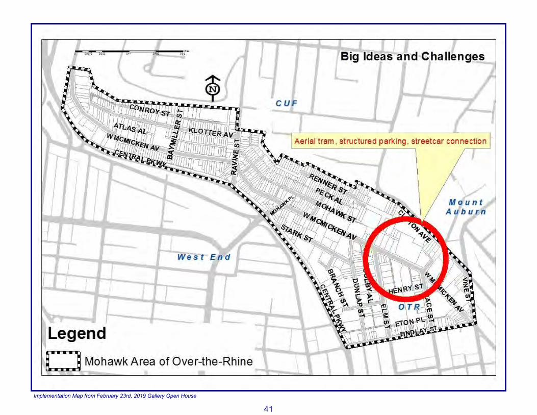
Big Ideas and Challenges Goal: Develop Mohawk as an innovative and creative district that addresses challenges and implements big ideas. Strategy 1: Establish an aerial tram/incline up to Bellevue Park and include a bar or restaurant to symbolize Cincinnati’s rich history of inclines while also serving as an innovative transportation option. • Collaborate with the Department of Transportation and
Engineering and the Parks Department to devise a plan for the aerial tram implementation.
(Please see Big Ideas and Challenges “Implementation Map” on opposite page for more information.)
41
Implementation Map from February 23rd, 2019 Gallery Open House

42
(This page is intentionally left blank)

43
Prioritization
Notes On Wednesday, January 23rd 2019, members of the Mohawk community participated in a public input session to prioritize the ten Vision strategies. The following table represents the results of that meeting, and the ten Vision strategies are organized in descending order based on their “priority score.” The “priority score” reflects the number of dots that the strategies received at that charette workshop. The ten Strategies also contain action items, which are ordered by their suggested “Level of Difficulty,” as determined by city staff. As a reference, potential partners for completing those action items, as well as their theoretical timelines, are provided. While the Prioritization Table reflects the community’s priorities and suggested timelines, the potential partners and timelines themselves are non-binding. The purpose of the priority table is designed to help coordinate community action, but the community may choose to complete action items in any order. Furthermore, it is important to note that these changes are driven by the community and for the community, in partnership with non-profits, non-governmental organizations, and the City of Cincinnati.
Key In order to condense information in the table, the names of some organizations and city departments are abbreviated and shortened. Below is a key to those abbreviations:
• “Mohawk” = Mohawk residents, business owners, property owners, and all other members of the community
• “MNBD” = Mohawk Neighborhood Business District • “OTRCC” = Over-the-Rhine Community Council • “CNBDU” = Cincinnati Neighborhood Business Districts
United • “BDCURC” = Brewery District Community Urban
Redevelopment Corporation • “OTRCH” = Over-the-Rhine Community Housing • “Model” = Model Group • “CMHA” = Cincinnati Metropolitan Housing Authority • “Planning” = City of Cincinnati Department of City Planning • “DCED” = City of Cincinnati Department of Community and
Economic Development • “B&I” = City of Cincinnati Department of Buildings and
Inspections • “DOTE” = City of Cincinnati Department of Transportation
and Engineering • “SORTA” = Southwest Ohio Regional Transit Authority • “Public Services” = City of Cincinnati Department of Public
Services • “Historic” = City of Cincinnati Historic Conservation Office • “Parks” = City of Cincinnati Parks Department • “CPD” = City of Cincinnati Police Department • “City Council” = City of Cincinnati City Council

44
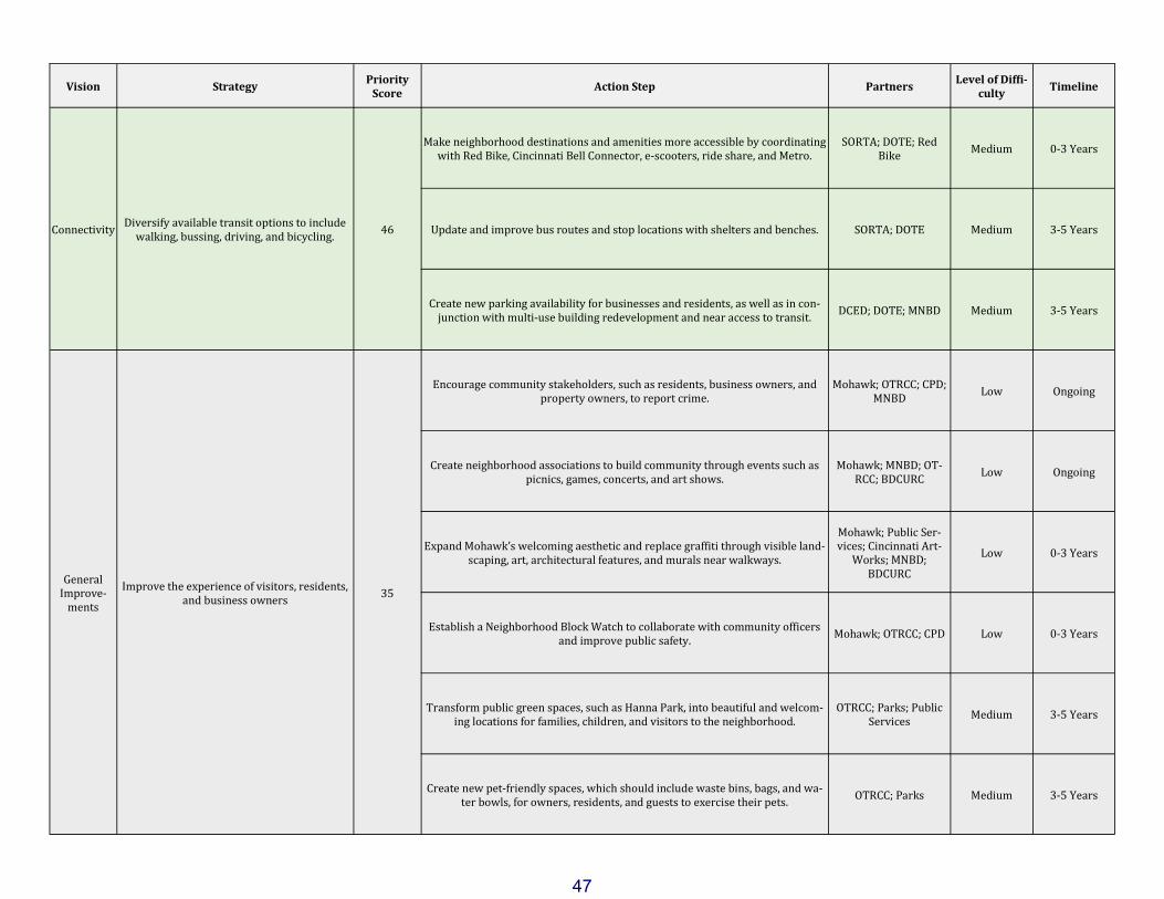
Vision Strategy
Priority Score
Action Step Partners Level of Diffi-
culty Timeline
Economic Develop-
ment Develop the business district. 61
Coordinate with the Brewing Heritage Trail to celebrate the unique history of Mohawk, which includes brewing, the Miami & Erie Canal, packing houses, met-
alworking, and other cultural, social, and economic activities.
BDCURC; OTRCC; MNBD
Low 0-3 Years
Coordinate with property owners to learn more about the benefits and responsi-bilities of owning historic property in the Mohawk Historic District.
Mohawk; MNBD; B&I; OTRCC; DCED; Historic
Low 0-3 Years
Assist property owners on the processes and requirements of obtaining building permits, and work with property owners to ensure that proper permit proce-
dures are followed. Mohawk; MNBD; B&I Low 0-3 Years
Establish a Mohawk business association and create a business district recog-nized by Cincinnati Neighborhood Business District United (CNBDU).
Mohawk; MNBD; OT-RCC; DCED; CNBDU;
Planning Medium 0-3 Years
Explore additional sources of funding (Federal or State Historic Tax Credits, TIF, New Market Tax Credits) to restore historic structures, such as the Imperial
Theater, the Jackson Brewery, the Felsenbrau buildings, and the Sohn/Clyffside Brewery, as catalysts for future investment.
MNBD; BDCURC; DCED; City Council
Medium 3-5 Years
Explore interest in implementing a façade program, streetscape improvements and additional parking options.
MNBD; BDCURC; DCED; City Council
Medium 3-5 Years
Economic Develop-
ment Promote neighborhood-specific infill. 61
Encourage future developers to rehabilitate Mohawk’s historic architecture and promote opportunities for new business growth.
Mohawk; MNBD; B&I; DCED
Low Ongoing
Educate property owners on property maintenance best practices and collabo-rate with the Department of Buildings and Inspections to ensure adequate prop-
erty maintenance.
Mohawk; MNBD; B&I; OTRCC
Low 0-3 Years
Establish neighborhood associations to help residents easily communicate with one another as well as assemble funding for certain projects.
Mohawk; MNBD; OT-RCC, BOCURC
Low 0-3 Years
Incentivize building and property owners to activate properties and participate in the revitalization of the neighborhood.
Mohawk; MNBD; DCED; City Council;
OTRCC, BOCURC Medium 0-3 Years

45
Vision Strategy Priority
Score Action Step Partners
Level of Diffi-culty
Timeline
General Improve-
ments Improve the built environment. 57
Increase maintenance of alleyways and public spaces. B&I; Public Services Low Ongoing
Improve lighting in the Mohawk neighborhood. DOTE; Public Services;
MNBD Low 0-3 Years
Increase amount of waste and recycling bins at regular intervals along walk-ways.
Public Services Low 0-3 Years
Inspire and encourage residents and businesses to participate in Mohawk’s beautification by maintaining and repainting their buildings, as well as improv-
ing vacant properties.
Mohawk; MNBD; B&I; DCED; OTRCC
Medium 0-3 Years
Big Ideas and Chal-
lenges
Establish an aerial tram/incline up to Bellevue Park and include a bar or restaurant to sym-
bolize Cincinnati’s rich history of inclines while also serving as an innovative transpor-
tation option.
55 Collaborate with the Department of Transportation and Engineering and the
Parks Department to devise a plan for the aerial tram implementation.
Mohawk; City Council; OTRCC; BDCURC;
DOTE; Parks; DCED, MNBD
High 5+ Years

46
Vision Strategy
Priority Score
Action Step Partners Level of Diffi-
culty Timeline
Connectivity Develop a walkable neighborhood business
district/entertainment district. 52
Minimize curb cuts. DOTE Low Ongoing
Locate new buildings and structures with zero or minimal set-backs, where frontage is on or near sidewalks.
Planning; DCED Low Ongoing
Maintain good sidewalk and historic stairway conditions including reporting needs for repairs and improvements.
DOTE; Public Services Low Ongoing
Change CN-M (Commercial Neighborhood Mixed) zoning to CN-P (Commercial Neighborhood Pedestrian) or UM (Urban Mix), with a focus on McMicken Ave-
nue, to enhance Mohawk’s pedestrian-friendliness.
Planning; OTRCC; City Council
Low 0-3 Years
Plant more street trees and streetscaping along main thoroughfares. Parks Low 0-3 Years
Increase sidewalk signs and ensure that crosswalks and crosswalk signs are clear and visible.
DOTE; Public Services Low 0-3 Years
Re-evaluate bus stop locations to maximize connectivity to the neighborhood. SORTA; OTRCC; DOTE Medium 3-5 Years
Improve traffic calming along West McMicken. DOTE; Public Services Medium 3-5 Years
Improve pedestrian connectivity by increasing crosswalk frequency and signage at key intersections such as Central Parkway/Mohawk Place/Linn Street, Ravine
Street/McMicken Avenue, and Stonewall Street/McMicken Avenue. DOTE Medium 3-5 Years
Connect the different areas of the neighborhood in a cohesive manner, including West End across Central Parkway and CUF at West McMicken Avenue.
DOTE Medium 3-5 Years
47
Vision Strategy
Priority Score
Action Step Partners Level of Diffi-
culty Timeline
Connectivity Diversify available transit options to include
walking, bussing, driving, and bicycling. 46
Make neighborhood destinations and amenities more accessible by coordinating with Red Bike, Cincinnati Bell Connector, e-scooters, ride share, and Metro.
SORTA; DOTE; Red Bike
Medium 0-3 Years
Update and improve bus routes and stop locations with shelters and benches. SORTA; DOTE Medium 3-5 Years
Create new parking availability for businesses and residents, as well as in con-junction with multi-use building redevelopment and near access to transit.
DCED; DOTE; MNBD Medium 3-5 Years
General Improve-
ments
Improve the experience of visitors, residents, and business owners
35
Encourage community stakeholders, such as residents, business owners, and property owners, to report crime.
Mohawk; OTRCC; CPD; MNBD
Low Ongoing
Create neighborhood associations to build community through events such as picnics, games, concerts, and art shows.
Mohawk; MNBD; OT-RCC; BDCURC
Low Ongoing
Expand Mohawk’s welcoming aesthetic and replace graffiti through visible land-scaping, art, architectural features, and murals near walkways.
Mohawk; Public Ser-vices; Cincinnati Art-
Works; MNBD; BDCURC
Low 0-3 Years
Establish a Neighborhood Block Watch to collaborate with community officers and improve public safety.
Mohawk; OTRCC; CPD Low 0-3 Years
Transform public green spaces, such as Hanna Park, into beautiful and welcom-ing locations for families, children, and visitors to the neighborhood.
OTRCC; Parks; Public Services
Medium 3-5 Years
Create new pet-friendly spaces, which should include waste bins, bags, and wa-ter bowls, for owners, residents, and guests to exercise their pets.
OTRCC; Parks Medium 3-5 Years

48
Vision Strategy Priority
Score Action Step Partners
Level of Diffi-culty
Timeline
Housing Promote architecturally compatible and con-
sistent infill 31
Unify residential and business organizations to promote productive communica-tion and apply for project funding.
Mohawk; MNBD; Plan-ning; DCED; B&I; His-
toric Low Ongoing
Require that residential infill, including but not limited to single- and multi-family structures, remain consistent with the architectural and pedestrian-
friendly character and density of Mohawk within and surrounding the Sohn-Mohawk Historic District.
Mohawk; Historic ; MNBD; OTRCC
Medium Ongoing
Encourage property owners to activate vacant units and prioritize filling resi-dential units above street-level commercial spaces.
Mohawk; Model; OT-RCH; CMHA; B&I
Medium 3-5 Years
Connectivity Redesign the Mohawk area’s gateway 26 Transform the Central Parkway/Mohawk Place/West McMicken Avenue neigh-borhood entrance into a walkable plaza surrounded by businesses and residen-
tial uses that would be closed to vehicle traffic for special events. OTRCC: DOTE High 5+ Years
Connectivity Enhance the biking experience in the neigh-
borhood business district. 20
Implement wayfinding tools such as biking signs to direct bike riders. DOTE; Public Services Low 0-3 Years
Evaluate existing bike lanes and create new bike infrastructure to maximize efficiency and connectivity to the neighborhood.
OTRCC: DOTE; Red Bike
Medium 3-5 Years