THE NEWFOUNDLAND AND LABRADOR GAZETTE · Situate near Lake Ambrose, Central NL On map sheet Company...
212
289 THE NEWFOUNDLAND AND LABRADOR GAZETTE PART I PUBLISHED BY AUTHORITY Vol. 91 ST. JOHN’S, FRIDAY, SEPTEMBER 16, 2016 No. 37 CANADA-NEWFOUNDLAND AND LABRADOR ATLANTIC ACCORD IMPLEMENTATION ACT and CANADA-NEWFOUNDLAND AND LABRADOR ATLANTIC ACCORD IMPLEMENTATION NEWFOUNDLAND AND LABRADOR ACT CANADA-NEWFOUNDLAND AND LABRADOR OFFSHORE PETROLEUM BOARD ISSUANCE OF EXPLORATION LICENCE - EXCHANGE OF INTEREST Pursuant to paragraph 61(1)(b) of the Canada-Newfoundland and Labrador Atlantic Accord Implementation Act, S.C., 1987, c. 3, and paragraph 60(1)(b) the Canada-Newfoundland and Labrador Atlantic Accord Implementation Newfoundland and Labrador Act, RSNL1990 cC-2, the CANADA-NEWFOUNDLAND AND LABRADOR OFFSHORE PETROLEUM BOARD proposes to issue a new exploration licence in exchange for a surrender of existing Exploration Licence No. 1105 issued to Corridor Resources Inc. in the Canada-Newfoundland and Labrador Offshore Area. The issuance of this proposed exploration licence will provide appropriate time for a robust review process associated with a proposed drilling operations authorization and validation of the geological prospect commonly referred to as Old Harry by restoring the term of the licence to four years. No drilling can occur on the proposed exploration licence lands without approval from the CANADA-NEWFOUNDLAND AND LABRADOR OFFSHORE PETROLEUM BOARD. The issuance of this proposed interest is a fundamental decision subject to approval by the respective Accord Act Ministers. If approved, the proposed exploration license will be issued in relation to the same lands as Exploration License No. 1105. The full text of the proposed exploration licence is available upon request made to the Registrar, Canada-Newfoundland and Labrador Offshore Petroleum Board, TD Place, 5 th Floor, 140 Water Street, St. John's, Newfoundland and Labrador A1C 6H6, (709) 778-1400. CANADA-NEWFOUNDLAND AND LABRADOR OFFSHORE PETROLEUM BOARD Scott Tessier, Chair and Chief Executive Officer Sept 16
Transcript of THE NEWFOUNDLAND AND LABRADOR GAZETTE · Situate near Lake Ambrose, Central NL On map sheet Company...
289
THE NEWFOUNDLAND
AND LABRADOR GAZETTE
PART I
PUBLISHED BY AUTHORITY
Vol. 91 ST. JOHN’S, FRIDAY, SEPTEMBER 16, 2016 No. 37
CANADA-NEWFOUNDLAND AND LABRADOR ATLANTIC ACCORD IMPLEMENTATION ACT and
CANADA-NEWFOUNDLAND AND LABRADOR ATLANTIC ACCORD IMPLEMENTATION NEWFOUNDLAND AND LABRADOR ACT
CANADA-NEWFOUNDLAND AND LABRADOR OFFSHORE PETROLEUM BOARD
ISSUANCE OF EXPLORATION LICENCE - EXCHANGE OF INTEREST
Pursuant to paragraph 61(1)(b) of the Canada-Newfoundland and Labrador Atlantic Accord Implementation Act, S.C., 1987, c. 3, and paragraph 60(1)(b) the Canada-Newfoundland and Labrador Atlantic Accord Implementation Newfoundland and Labrador Act, RSNL1990 cC-2, the CANADA-NEWFOUNDLAND AND LABRADOR OFFSHORE PETROLEUM BOARD proposes to issue a new exploration licence in exchange for a surrender of existing Exploration Licence No. 1105 issued to Corridor Resources Inc. in the Canada-Newfoundland and Labrador Offshore Area. The issuance of this proposed exploration licence will provide appropriate time for a robust review process associated with a proposed drilling operations authorization and validation of the geological prospect commonly referred to as Old Harry by restoring the term of the licence to four years. No drilling can occur on the proposed exploration licence lands without approval from the CANADA-NEWFOUNDLAND AND LABRADOR OFFSHORE PETROLEUM BOARD. The issuance of this proposed interest is a fundamental decision subject to approval by the respective Accord Act Ministers. If approved, the proposed exploration license will be issued in relation to the same lands as Exploration License No. 1105. The full text of the proposed exploration licence is available upon request made to the Registrar, Canada-Newfoundland and Labrador Offshore Petroleum Board, TD Place, 5th Floor, 140 Water Street, St. John's, Newfoundland and Labrador A1C 6H6, (709) 778-1400.
CANADA-NEWFOUNDLAND AND LABRADOR OFFSHORE PETROLEUM BOARD Scott Tessier, Chair and Chief Executive Officer
Sept 16
THE NEWFOUNDLAND AND LABRADOR GAZETTE September 16, 2016
290
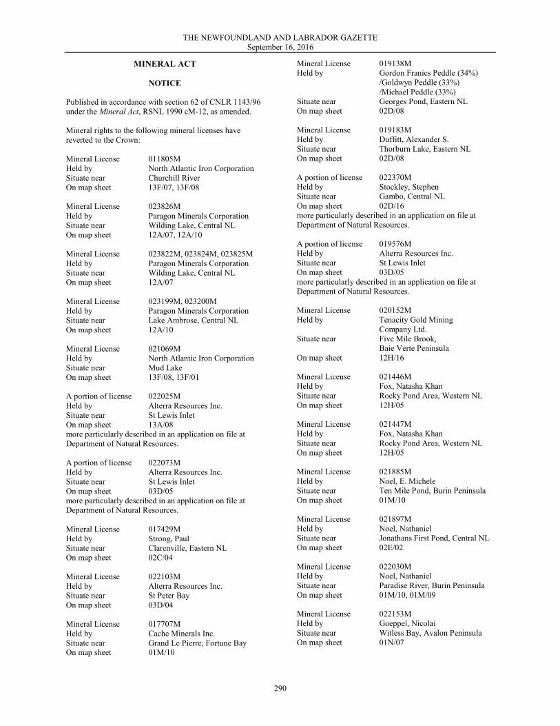
MINERAL ACT
NOTICE Published in accordance with section 62 of CNLR 1143/96 under the Mineral Act, RSNL 1990 cM-12, as amended. Mineral rights to the following mineral licenses have reverted to the Crown: Mineral License 011805M Held by North Atlantic Iron Corporation Situate near Churchill River On map sheet 13F/07, 13F/08 Mineral License 023826M Held by Paragon Minerals Corporation Situate near Wilding Lake, Central NL On map sheet 12A/07, 12A/10 Mineral License 023822M, 023824M, 023825M Held by Paragon Minerals Corporation Situate near Wilding Lake, Central NL On map sheet 12A/07 Mineral License 023199M, 023200M Held by Paragon Minerals Corporation Situate near Lake Ambrose, Central NL On map sheet 12A/10 Mineral License 021069M Held by North Atlantic Iron Corporation Situate near Mud Lake On map sheet 13F/08, 13F/01 A portion of license 022025M Held by Alterra Resources Inc. Situate near St Lewis Inlet On map sheet 13A/08 more particularly described in an application on file at Department of Natural Resources. A portion of license 022073M Held by Alterra Resources Inc. Situate near St Lewis Inlet On map sheet 03D/05 more particularly described in an application on file at Department of Natural Resources. Mineral License 017429M Held by Strong, Paul Situate near Clarenville, Eastern NL On map sheet 02C/04 Mineral License 022103M Held by Alterra Resources Inc. Situate near St Peter Bay On map sheet 03D/04 Mineral License 017707M Held by Cache Minerals Inc. Situate near Grand Le Pierre, Fortune Bay On map sheet 01M/10
Mineral License 019138M Held by Gordon Franics Peddle (34%) /Goldwyn Peddle (33%) /Michael Peddle (33%) Situate near Georges Pond, Eastern NL On map sheet 02D/08 Mineral License 019183M Held by Duffitt, Alexander S. Situate near Thorburn Lake, Eastern NL On map sheet 02D/08 A portion of license 022370M Held by Stockley, Stephen Situate near Gambo, Central NL On map sheet 02D/16 more particularly described in an application on file at Department of Natural Resources. A portion of license 019576M Held by Alterra Resources Inc. Situate near St Lewis Inlet On map sheet 03D/05 more particularly described in an application on file at Department of Natural Resources. Mineral License 020152M Held by Tenacity Gold Mining Company Ltd. Situate near Five Mile Brook, Baie Verte Peninsula On map sheet 12H/16 Mineral License 021446M Held by Fox, Natasha Khan Situate near Rocky Pond Area, Western NL On map sheet 12H/05 Mineral License 021447M Held by Fox, Natasha Khan Situate near Rocky Pond Area, Western NL On map sheet 12H/05 Mineral License 021885M Held by Noel, E. Michele Situate near Ten Mile Pond, Burin Peninsula On map sheet 01M/10 Mineral License 021897M Held by Noel, Nathaniel Situate near Jonathans First Pond, Central NL On map sheet 02E/02 Mineral License 022030M Held by Noel, Nathaniel Situate near Paradise River, Burin Peninsula On map sheet 01M/10, 01M/09 Mineral License 022153M Held by Goeppel, Nicolai Situate near Witless Bay, Avalon Peninsula On map sheet 01N/07
THE NEWFOUNDLAND AND LABRADOR GAZETTE September 16, 2016
291
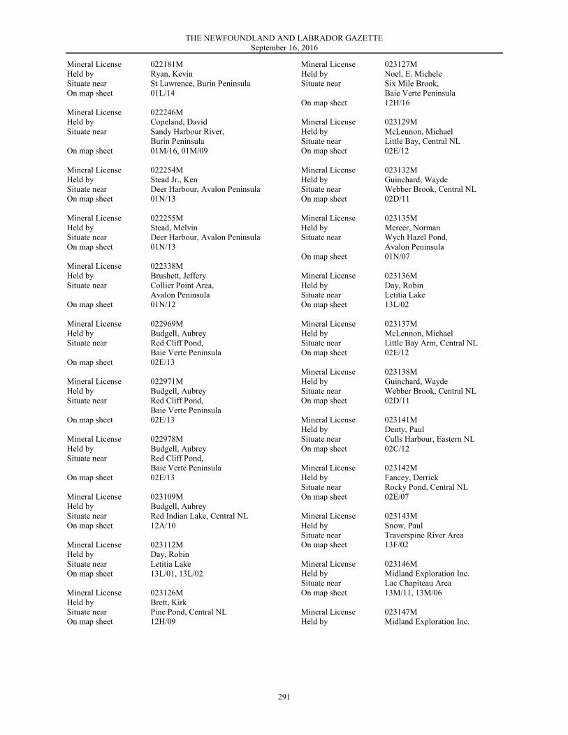
Mineral License 022181M Held by Ryan, Kevin Situate near St Lawrence, Burin Peninsula On map sheet 01L/14 Mineral License 022246M Held by Copeland, David Situate near Sandy Harbour River, Burin Peninsula On map sheet 01M/16, 01M/09 Mineral License 022254M Held by Stead Jr., Ken Situate near Deer Harbour, Avalon Peninsula On map sheet 01N/13 Mineral License 022255M Held by Stead, Melvin Situate near Deer Harbour, Avalon Peninsula On map sheet 01N/13 Mineral License 022338M Held by Brushett, Jeffery Situate near Collier Point Area, Avalon Peninsula On map sheet 01N/12 Mineral License 022969M Held by Budgell, Aubrey Situate near Red Cliff Pond, Baie Verte Peninsula On map sheet 02E/13 Mineral License 022971M Held by Budgell, Aubrey Situate near Red Cliff Pond, Baie Verte Peninsula On map sheet 02E/13 Mineral License 022978M Held by Budgell, Aubrey Situate near Red Cliff Pond, Baie Verte Peninsula On map sheet 02E/13 Mineral License 023109M Held by Budgell, Aubrey Situate near Red Indian Lake, Central NL On map sheet 12A/10 Mineral License 023112M Held by Day, Robin Situate near Letitia Lake On map sheet 13L/01, 13L/02 Mineral License 023126M Held by Brett, Kirk Situate near Pine Pond, Central NL On map sheet 12H/09
Mineral License 023127M Held by Noel, E. Michele Situate near Six Mile Brook, Baie Verte Peninsula On map sheet 12H/16 Mineral License 023129M Held by McLennon, Michael Situate near Little Bay, Central NL On map sheet 02E/12 Mineral License 023132M Held by Guinchard, Wayde Situate near Webber Brook, Central NL On map sheet 02D/11 Mineral License 023135M Held by Mercer, Norman Situate near Wych Hazel Pond, Avalon Peninsula On map sheet 01N/07 Mineral License 023136M Held by Day, Robin Situate near Letitia Lake On map sheet 13L/02 Mineral License 023137M Held by McLennon, Michael Situate near Little Bay Arm, Central NL On map sheet 02E/12 Mineral License 023138M Held by Guinchard, Wayde Situate near Webber Brook, Central NL On map sheet 02D/11 Mineral License 023141M Held by Denty, Paul Situate near Culls Harbour, Eastern NL On map sheet 02C/12 Mineral License 023142M Held by Fancey, Derrick Situate near Rocky Pond, Central NL On map sheet 02E/07 Mineral License 023143M Held by Snow, Paul Situate near Traverspine River Area On map sheet 13F/02 Mineral License 023146M Held by Midland Exploration Inc. Situate near Lac Chapiteau Area On map sheet 13M/11, 13M/06 Mineral License 023147M Held by Midland Exploration Inc.
THE NEWFOUNDLAND AND LABRADOR GAZETTE September 16, 2016
292
Situate near Lac Chapiteau Area On map sheet 13M/11 Mineral License 023148M Held by Midland Exploration Inc. Situate near Lac Chapiteau Area On map sheet 13M/06 Mineral License 023149M Held by Midland Exploration Inc. Situate near Lac Chapiteau Area On map sheet 13M/11 Mineral License 023150M Held by Midland Exploration Inc. Situate near Lac Chapiteau Area On map sheet 13M/06 Mineral License 023151M Held by Midland Exploration Inc. Situate near Mistastin Lake On map sheet 13M/13 Mineral License 023152M Held by Midland Exploration Inc. Situate near Mistastin Lake On map sheet 13M/13 Mineral License 023154M Held by Warren, Perry Situate near Gander Lake, Central NL On map sheet 02D/15 Mineral License 023157M Held by Snow, Paul Situate near Muskrat Falls On map sheet 13F/07 Mineral License 023162M Held by Reid, N. Wayne
Situate near West Tally Pond, Central NL On map sheet 12A/10, 2A/09 Mineral License 023411M Held by Fox, Natasha Khan Situate near Rocky Pond Area, Western NL On map sheet 12H/05 Mining Lease 133 (2359) Held by Teck Resources Limited Situate near Tally Pond, Central NL On map sheet 12A/9 Areas in the Smallwood Reservoir Exempt Mineral Land above the elevation contours described in Appendix B to the draft Lease annexed to the Hamilton Falls Power Corporation Limited Lease Act, 1961, as amended. The lands covered by this notice except for the lands within Exempt Mineral Lands, the Exempt Mineral Lands being described in CNLR 1143/96 and NLR 71/98, 104/98, 97/00, 36/01, 31/04, 78/06, 8/08, 28/09 and 5/13 and outlined on 1:50 000 scale digital maps maintained by the Department of Natural Resources, will be open for staking after the hour of 9:00 a.m. on the 32nd clear day after the date of this publication.
DEPARTMENT OF NATURAL RESOURCES Justin Lake, Manager - Mineral Rights
File #'s 774: 5221, 6110, 8293, 8413, 9649, 9737
775: 0683, 0956, 1137, 1144, 2406, 2412, 2446, 2765, 2785, 3178, 4023, 4024, 4332, 4344, 4389, 4435, 4445, 4517, 4525, 4526, 4573, 4945, 4947, 4954, 5034, 5038, 5048, 5050, 5052, 5055, 5058, 5059, 5060, 5061, 5062, 5063, 5064, 5067, 5068, 5069, 5070, 5071, 5072, 5073, 5075, 5078, 5082, 5253
Sept 16
EMBALMERS AND FUNERAL DIRECTORS ACT, 2008
NOTICE
The following is a list of names and addresses of Funeral Directors to whom licenses and permits have been issued under the Embalmers and Funeral Directors Act, 2008, SNL2008 cE-7.1, as amended.
Embalmers and Funeral Directors Board of NL Customer List as of 09/06/2016
Anderson, Lisa D. Andrews, Darrin W. Barrett, R. David Barrett, Robert R. Barry, Ann Marie Broughton, Kenneth Brown, Holly Bulgin, Andrea Carnell, Geoffrey Chaulk, David Colbourne, Coreen Coombs, Andrew Coombs, Jeanette Cumben, Thomas R.
Fahey, Esther Fahey, Gerald K. Farr, Harley K. Farr, Kimberly D. Fillatre, Laura Fillatre, Levinia Fillatre, Margaret Gibbons, George Gibbons, Jean M. Goodyear, Sheila Hancock, Gail Hansford, Christopher Hansford, Kimberley Hickey, Jamie N.
Hiscock, Gordon Holloway, Ruby Hopkins, Carl Hopkins, William Hoskins, Debi Hulan, Amanda H. Kelly, Florence M. Lomond, Geoffrey Mercer, Wayne Moore, Clarence L. E. Moore, Lisa Moore--Reid, Clarice Morgan, Chris
THE NEWFOUNDLAND AND LABRADOR GAZETTE September 16, 2016
293
Newport, Ellison Noel, Jonathan Oram, Dawson Oram, Elizabeth Oram, Karen P. Oram, Paul Parsons, Brenda D. Peach, Milton L.
Pendergast, John F. Ridgley--MacDonald, Denise Russell, Amanda Short, Justin Slade, Elizabeth Slade, Ross Spencer, Mark D. Squires, Josephine
Stockley, Catherine J. Tucker, Twyla Vardy, Arthur R. Vardy, Doris Warren, G. Paul Warren, Wynn Anne Wimbleton-Butt, Lisa Wiseman, Tammy
Number of Customers listed: 65 - Generated On: 09/06/2016
EMBALMERS AND FUNERAL DIRECTORS BOARD OF NEWFOUNDLAND AND LABRADOR
Valda Pitcher, Office Secretary Sept 16
The following is a list of names and addresses of Embalmers and Funeral Directors to whom licenses and permits have been issued under the Embalmers and Funeral Directors Act, 2008, SNL2008 cE-7.1, as amended. Embalmers and Funeral Directors Board of NL - Customer List as of 09/06/2016
Abbott, Brent Anderson, John F. Anderson, John N. Anderson, Robert Andrews, Jessica M. Barrett, Colin Barrett, Susan Barrington, Martin Belbin, Giselle Bishop, Derek Blackler, Brandon Blundon, Lorraine Boyd, Rhonda Broughton, Wayne S. Brown, Rebecca Burke, Amy Burry, Amy Chambers, Sherilee Chislett, Tracey Collier, Sarah Coombs, Francis Coombs, Thomas Cunning, Baden Currie, Amanda Currie, Jennifer Doody, Lisa Marie Dowden, Peter Dunphy, Barbara Dunphy, Kenneth Eddy, Roger W. Fahey, Gerald P. Fahey, Justin Farr, Thomas S. Fewer, Desmond Fewer, Robert Fillatre, A. Maxwell Fillatre, Ernest Fillatre, Keith W. Fitzgerald, Matthew Flaherty, Joseph Flood, Raymond F.
Foster, Mark Gillingham, Gurrin A. Goodyear, Kenneth Goodyear, Michael T. Green, Andrew Green, Donald Green, Terry P. Hanna, Orry Hickey, Andrew Hickey, James Hill--Scammell, Nova Lee Hodder, Jeffrey Holloway, Garry Holloway, Mindy Hoskins, Paul L. Howe, Jonathan Hulan, Jason Hynes, Sheldon Ivany, Maxine Kean-Simms, Paula Keats, Garry Kieley, Darren Lane, Erin Lannon, Vanessa Legge, Eric (Rick) Lewis, Carol Ann Lewis, Marcia Loveridge, Julianne Lynch, Wayne Maher, Paul Maidment, James Martin, Morgan Mauger, Siobhan McCormick, Paula McGrath, Michelle Mercer, Michael Mooney, David Moore, Alice D. Moore, Carl R. Mouland, Shane Mouland, Tracy
Nippard, Lee Nippard, Nathan Noel, Kenneth E. Oliver, Mark Oram, Zach Parsons, David E. Parsons, Debra Parsons, Dwayne S. Pender, Jennifer Penney, John F. Power, Damian Pritchett, Kevin D. Quinton, Rodney Roberts, Renetta Roche, Edward Ruelokke, Beatrice Russell, Keith R. Ryan, Brandon Ryan, Joseph Sampson, Jonathan Skiffington, Pamela Slade, Edward Slade-Kennedy, Krista Slade--Ryan, Katherine Spencer, Creston Spracklin, Danielle Stack, Wanda Strathie, Cluny H. Strathie, Robert R. Tizzard, Shawn Trenchard , Barry Wade, Daryl R. Warren, Craig C. Warren, Shirley G. Weeks, William J. Whalen, Krista White, Connie E. Wimbleton, Eddie Wiseman, Terry Woolfrey, Gordon J. G.
Number of Customers listed: 122 - Generated On: 09/06/2016
EMBALMERS AND FUNERAL DIRECTORS BOARD OF NEWFOUNDLAND AND LABRADOR
Valda Pitcher, Office Secretary Sept 16
THE NEWFOUNDLAND AND LABRADOR GAZETTE September 16, 2016
294
The following is a list of names and addresses of Funeral Homes to whom licenses and permits have been issued under the Embalmers and Funeral Directors Act, 2008, SNL2008 cE-7.1, as amended. Embalmers and Funeral Directors Board of NL - Customer List as of 09/06/2016 Name Street 1 City Province Postal Code Barrett's Funeral Home Mt. Pearl 73 Commonwealth Avenue Mount Pearl NL A1N 1W7 Barrett's Funeral Home St. John's 328 Hamilton Avenue St. John's NL A1E 1J9 Bishop's Falls Funeral and Cremation Services 45 Union Street Grand Falls-Windsor NL A2A 2C9 Blundon's Funeral Home-Clarenville 8 Harbour Drive Clarenville NL A5A 4H6 Botwood Funeral Home 147 Commonwealth Drive Botwood NL A0H 1E0 Broughton's Funeral Home P. O. Box 14 Brigus NL A0A 1K0 Carnell's Funeral Home Ltd. 329 Freshwater Road St. John's NL A1B 3P2 Caul's Funeral Home St. John's P. O. Box 2117 St. John's NL A1C 5R6 Caul's Funeral Home Torbay P. O. Box 2117 St. John's NL A1C 5R6 Central Funeral and Cremation Services 45 Union Street Grand Falls-Windsor NL A2A 2C9 Coomb’s Funeral Home P. O. Box 267 Placentia NL A0B 2Y0 Country Haven Funeral Home 167 Country Road Corner Brook NL A2H 4M5 Don Gibbons Enterprises Ltd. P. O. Box 424 St. Mary's NL A0B 3B0 Dunphy's Funeral Home P. O. Box 56 Holyrood NL A0A 2R0 East Haven Funeral Home Inc. 57 Grand Bay Road Port Aux Basques NL A0M 1C0 Fahey's Funeral Home-Fermeuse General Delivery Fermeuse NL A0A 2G1 Fahey's Funeral Home-Trepassey General Delivery Fermeuse NL A0A 2G1 Families Funeral Home 9 Forward Drive Lewisporte NL A0G 3A0 Fewer's Funeral Home-Arnolds Cove 299 Memorial Drive Clarenville NL A5A 1R6 Fewer's Funeral Home-Clarenville 299 Memorial Drive Clarenville NL A5A 1R6 Fewer's Funeral Home-Little Hearts Ease 299 Memorial Drive Clarenville NL A5A 1R6 Fewer's Funeral Home-Lethbridge 299 Memorial Drive Clarenville NL A5A 1R6 Fillatre's Funeral Home, Corner Brook 218 Curling Street Corner Brook NL A2H 3J4 Fillatre's Funeral Home, Deer Lake 218 Curling Street Corner Brook, NL A2H 3J4 Fillatre's Funeral Home, HV/GB 218 Curling Street Corner Brook NL A2H 3J4 Fillatre's Funeral Home, Mark's Ave 218 Curling Street Corner Brook NL A2H 3J4 Fillatre's Stephenville Crossing 218 Curling Street Corner Brook NL A2H 3J4 Fillatre's, Port Au Choix 218 Curling Street Corner Brook NL A2H 3J4 Fillatre's, Port Aux Basques 218 Curling Street Corner Brook NL A2H 3J4 Flaherty's Memorial Funeral Home P. O. Box 193 Conception Harbour NL A0A 1Z0 Fogo Island Funeral Home P.O. Box 13 Joe Batts Arm NL A0G 2X0 Green Bay Funeral Home 145 Cpl. S. Bouzaine Blvd. Springdale NL A0J 1T0 Green's Funeral Home P. O. Box 138 Winterton NL A0B 3M0 Hickey's Funeral Home-Kelligrews P. O. Box 419 Holyrood NL A0A 2R0 Holloway's Funeral Home P. O. Box 42 Whitbourne NL A0B 3K0 Hopkin's Funeral Home-Northern Bay P. O. Box 262 Old Perlican NL A0A 3G0 Hopkin's Funeral Home-Old Perlican P. O. Box 262 Old Perlican NL A0A 3G0 Hoskins' Funeral Home-Bishops Falls P. O. Box 189 Bishop's Falls NL A0H 1C0 Hoskins' Funeral Home-Botwood P. O. Box 189 Bishop's Falls NL A0H 1C0 Hoskins' Funeral Home-Grand Falls-Windsor P. O. Box 189 Bishop's Falls NL A0H 1C0 Hynes' Coast of Bays Funeral Home P. O. Box 44 St. Alban's NL A0H 2E0 Isles Funeral Home Ltd. 2 Whitehorne's Hill Twillingate NL A0G 4M0 James J. Hickey Memorial Funeral Home P. O. Box 419 Holyrood NL A0A 2R0 K. M. Fillatre Funeral Home-Roddickton P. O. Box 604 St. Anthony NL A0K 4S0 K. M. Fillatre Funeral Home-St. Anthony P. O. Box 604 St. Anthony NL A0K 4S0 Kittiwake Funeral Home P. O. Box 39 Wesleyville NL A0G 4R0 Kittiwake Funeral Home-Musgrave Harbour P. O. Box 39 Wesleyville NL A0G 4R0 Lynch's Funeral Home Ltd.-Spaniard's Bay 95 Brazil's Hill Spaniard's Bay NL A0A 3X0 Maher's Funeral Home P. O. Box 290 Freshwater NL A0B 1W0 Moore's Funeral Home P. O. Box 429 Clarke's Beach NL A0A 1W0 Moore's Funeral Home-Bay Roberts P. O. Box 429 Clarke's Beach NL A0A 1W0 New World Island Funeral Home P. O. Box 360 Summerford NL A0G 4E0 Noel's Funeral Home-Carbonear 106 Water Street Carbonear NL A1Y 1A9 Noel's Funeral Home-Harbour Grace P. O. Box 1001 Harbour Grace NL A0A 2M0 Noel's Funeral Home-Western Bay P. O. Box 1001 Harbour Grace NL A0A 2M0 Oram's Funeral Home P. O. Box 10 Glovertown NL A0G 2L0 Oram's Funeral Home-Dover P. O. Box 10 Glovertown NL A0G 2L0 Parson's Funeral Home 63 North Main Street Deer Lake NL A8A 1X1 Pendergast's Funeral Home P. O. Box 906 Bell Island NL A0A 4H0 Peninsula Funeral Home P. O. Box 548 Marystown NL A0E 2M0 Penney's Funeral Home 620 Hudson Drive Labrador City NL A2V 2K6 Pritchett's Funeral Home P. O. Box 796 Gambo NL A0G 1T0 Random Island Funeral Home P. O. Box 69 Hickman's Harbour NL A0C 1P0 Russell's Funeral Home-Prince Rupert 57 Prince Rupert Drive Stephenville NL A2N 2Z5
THE NEWFOUNDLAND AND LABRADOR GAZETTE September 16, 2016
295
Russell's Funeral Home-Stephenville Crossing 1 Station Road Stephenville Crossing NL A2N 2Y9 Ryan's Funeral Services Ltd. P. O. Box 306 Bay Bulls NL A0A 1C0 Serenity Funeral Home-Burin 95 Main Street Burin Bay Arm NL A0E 1G0 Sincerely Yours Funeral Home Limited Main Street New -Wes -Valley NL A0G 4R0 Sincerely Yours-Centreville 421 Pickersgill Blvd Centreville NL A0G 4P0 Slade's Funeral Home-Bay Roberts P. O. Box 324 Carbonear NL A1Y 1B7 Slade's Funeral Home-Upper Island Cove P. O. Box 324 Carbonear NL A1Y 1B7 Slade's Memorial Services Ltd. P. O. Box 324 Carbonear NL A1Y 1B7 Spencer's Funeral Home P. O. Box 248 Harbour Breton NL A0H 1P0 Spencer's Funeral Home-St. Alban's P. O. Box 248 Harbour Breton NL A0H 1P0 Springdale Funeral and Cremation Services 45 Union Street Grand Falls-Windsor NL A2A 2C9 Squire's Funeral Home P. O. Box 10 Glovertown NL A0G 2L0 Stacey's Funeral Home Gander P. O. Box 539 Gander NL A1V 2E1 Stacey's Funeral Home-Carmanville P. O. Box 539 Gander NL A1V 2E1 Strathie's Funeral Home P. O. Box 305 Bonavista NL A0C 1B0 Strathie's Funeral Home-Catalina P. O. Box 305 Bonavista NL A0C 1B0 Sunset Memorial Funeral Home 10 Bayley Street Grand Falls-Windsor NL A2A 2T5 Warren's Funeral Home-Dildo P. O. Box 123 Dildo NL A0B 1P0 Warren's Funeral Home-Grand Bank P.O. Box 309 Grand Bank NL A0E 1W0 Wimbleton's Funeral Home 22 Main Street Baie Verte NL A0K 1B0 Wiseman's Funeral Homes-Burin P. O. Box 548 Marystown NL A0E 2M0 Wiseman's Funeral Homes-Fortune P. O. Box 548 Marystown NL A0E 2M0 Wiseman's Funeral Homes-Marystown P. O. Box 548 Marystown NL A0E 2M0 Woolfrey, Gordon Funeral Home 262 Main Street Lewisporte NL A0G 3A0 Number of Customers listed: 88 - Generated On: 09/06/2016
EMBALMERS AND FUNERAL DIRECTORS BOARD OF NEWFOUNDLAND AND LABRADOR
Valda Pitcher, Office Secretary Sept 16
LANDS ACT
NOTICE OF INTENT Lands Act, SNL 1991 c36 as amended
NOTICE IS HEREBY given that JERRY and KELLY BROADERS of Joe Batt’s Arm, Newfoundland and Labrador intends to apply to the Department of Municipal Affairs, two months from the publication of this notice, to acquire title, pursuant to Section 7(2) (e) of the said Act, to that piece of Crown land situated within fifteen (15) metres of the waters of Notre Dame Bay in the Electoral District of Fogo – Cape Freels for the purpose of a boathouse/wharf and being more particularly described as follows:
Bounded on the North by Crown land for a distance of 15 metres;
Bounded on the East by property of Jerry and Kelly Broaders
for a distance of 25 metres; Bounded on the South by Crown land
for a distance of 15 metres; Bounded on the West by ocean
for a distance of 25 metres: and containing an area of
approximately 375 squares metres Any person wishing to object to the application must file the objection, in writing, within one month from the publication of this Notice, with reasons for it, to the Minister of Municipal Affairs, and mail to the nearest Regional Lands Office: c/o Eastern Regional Lands Office, P.O. Box 8700, Howley Building, Higgins Line, St. John’s, NL, A1B 4J6.
c/o Central Regional Lands Office, P.O. Box 2222, Gander, NL, A1V 1L7. c/o Western Regional Lands Office, P.O. Box 2006, Sir Richard Squires Building, Corner Brook, NL, A2H 6J8. c/o Labrador Regional Lands Office, P.O. Box 3014, Station “B”, Happy Valley-Goose Bay, NL, A0P 1E0. For further information on the proposed application, please contact: JERRY or KELLY BROADERS, Telephone Number: (519) 330-2593. (DISCLAIMER: The Newfoundland and Labrador Gazette publishes a NOTICE OF INTENT received from the Applicant and takes no responsibility for errors or omissions in the property being more particularly described.) Sept 16
TRUSTEE ACT
ESTATE NOTICE IN THE MATTER OF the Estate and Effects of Late GORDON FREAKE, of the Town of Gander, in the Province of Newfoundland and Labrador, Retired Person, Deceased.
All persons claiming to be creditors of or who have any claims or demands upon or affecting the Estate of GORDON FREAKE, the aforesaid Deceased, who died at Town of Gander, in the Province of Newfoundland and Labrador on or about the 15th day of June, 2013, are hereby requested to send particulars thereof in writing, duly attested, to the undersigned Solicitor for the Administrator of the Estate on or before the 23rd day of September, 2016
THE NEWFOUNDLAND AND LABRADOR GAZETTE September 16, 2016
296
after which date the Administrator will proceed to distribute the said Estate having regard only to the claims of which he shall then have had notice.
DATED AT the Town of Gander, Newfoundland and Labrador, this 29th day of August, 2016.
BONNELL LAW Solicitor for the Administrator
PER: R. Archibald Bonnell
ADDRESS FOR SERVICE: P.O. Box 563 218 Airport Boulevard Gander, NL A1V 2E1 Tel: (709) 651-4949 Fax: (709) 651-4951 Sept 9 & 16
THE NEWFOUNDLAND AND LABRADOR GAZETTE
PART II
SUBORDINATE LEGISLATION FILED UNDER THE STATUTES AND SUBORDINATE LEGISLATION ACT
Vol. 91 ST. JOHN’S, FRIDAY, SEPTEMBER 16, 2016 No. 37
NEWFOUNDLAND AND LABRADOR
REGULATIONS
NLR 49/16 NLR 50/16 NLR 51/16 NLR 52/16 NLR 53/16 NLR 54/16 NLR 55/16 NLR 56/16

The Newfoundland and Labrador Gazette September 16, 2016
451
NEWFOUNDLAND AND LABRADOR REGULATION 49/16
Big Game Caribou Order, Labrador, 2016-2017 under the
Wild Life Regulations and the
Wild Life Act
(Filed September 13, 2016)
Under the authority of sections 38, 92 and 114 of the Wild Life Regulations and the Wild Life Act, I make the following Order.
Dated at St. John’s, August 30, 2016.
Perry Trimper Minister of Environment and Climate Change
ORDER
Analysis
1. Short title 2. George River
caribou
3. Repeal
1. This order may be cited as the Big Game Caribou Order, Labrador, 2016-2017.
2. For the purposes of conservation, there shall be no open season in Labrador for the George River caribou.
Short title
George River caribou
Big Game Caribou Order, Labrador, 2016-2017 49/16
The Newfoundland and Labrador Gazette September 16, 2016
452
3. The Big Game Caribou Order, Labrador, 2015-2016, Newfoundland and Labrador Regulation 55/15, is repealed.
©Queen's Printer
Repeal

The Newfoundland and Labrador Gazette September 16, 2016
453
NEWFOUNDLAND AND LABRADOR REGULATION 50/16
Coyote Hunting Order, Newfoundland and Labrador, 2016-2017
under the Wild Life Regulations
and the Wild Life Act
(Filed September 13, 2016)
Under the authority of sections 81.2, 88 and 114 of the Wild Life Regulations and the Wild Life Act, I make the following Order.
Dated at St. John’s, August 30, 2016.
Perry Trimper Minister of Environment and Climate Change
ORDER
Analysis
1. Short title 2. Definition 3. Coyote licence holders 4. Other licence holders
5. Limit 6. Prohibition 7. Sunday hunting 8. Repeal
1. This Order may be cited as the Coyote Hunting Order, Newfoundland and Labrador, 2016-2017.
2. In this order, "coyote shooting licence" means a licence issued under section 81.1 of the Wild Life Regulations.
Short title
Definition
Coyote Hunting Order, Newfoundland and Labrador, 2016-2017
50/16
The Newfoundland and Labrador Gazette September 16, 2016
454
3. The open season for hunting of coyote by the holder of a coyote shooting licence is from September 10, 2016 to July 15, 2017.
4. (1) The holder of a big game, small game, trapper or wolf shooting licence is permitted to hunt coyote by shooting, in the area and during the open season for which his or her licence is valid.
(2) The holder of the licence referred to in subsection (1) shall only shoot coyotes using the type of firearm and ammunition that his or her licence permits.
(3) A person who shoots coyotes with a shotgun under the authority of this section shall use shot size 2 or larger.
5. There is no limit on the number of coyotes which may be shot by the holder of a coyote shooting licence or by a person under the authority of section 4.
6. A person shall not transport or possess any firearm under the authority of a valid game licence without being in possession of an outdoor identification card, or non-resident equivalent card, issued to that person.
7. Hunting with a firearm on Sundays shall be permitted across the entire province, beginning October 2, 2016 and ending April 30, 2017, for the species and only during the open seasons as described in this Order.
8. The Coyote Hunting Order, Newfoundland and Labrador, 2015-2016, Newfoundland and Labrador Regulation 56/15, is repealed.
©Queen's Printer
Coyote licence holders
Other licence holders
Limit
Prohibition
Sunday hunting
Repeal
The Newfoundland and Labrador Gazette September 16, 2016
455
NEWFOUNDLAND AND LABRADOR REGULATION 51/16
Furbearing Animals Trapping and Shooting Order, Newfoundland and Labrador, 2016-2017
under the Wild Life Regulations
and the Wild Life Act
(Filed September 13, 2016)
Under the authority of sections 16, 25, 27 and 114 of the Wild Life Regulations and the Wild Life Act, I make the following Order.
Dated at St. John’s, August 30, 2016.
Perry Trimper Minister of Environment and Climate Change
ORDER
Analysis
1. Short title 2. Open season trapping and
shooting 3. Prohibitions 4. Neck snares 5. Foot hold restraining traps 6. Killing traps 7. Live holding devices 8. Rate of beaver harvest 9. Lynx 10. Wolves 11. Prohibition 12. Sunday hunting
13. Repeal
Schedule A
Schedule B
Schedule C
Schedule D
Schedule E
Furbearing Animals Trapping and Shooting Order, Newfoundland and Labrador, 2016-2017
51/16
The Newfoundland and Labrador Gazette September 16, 2016
456
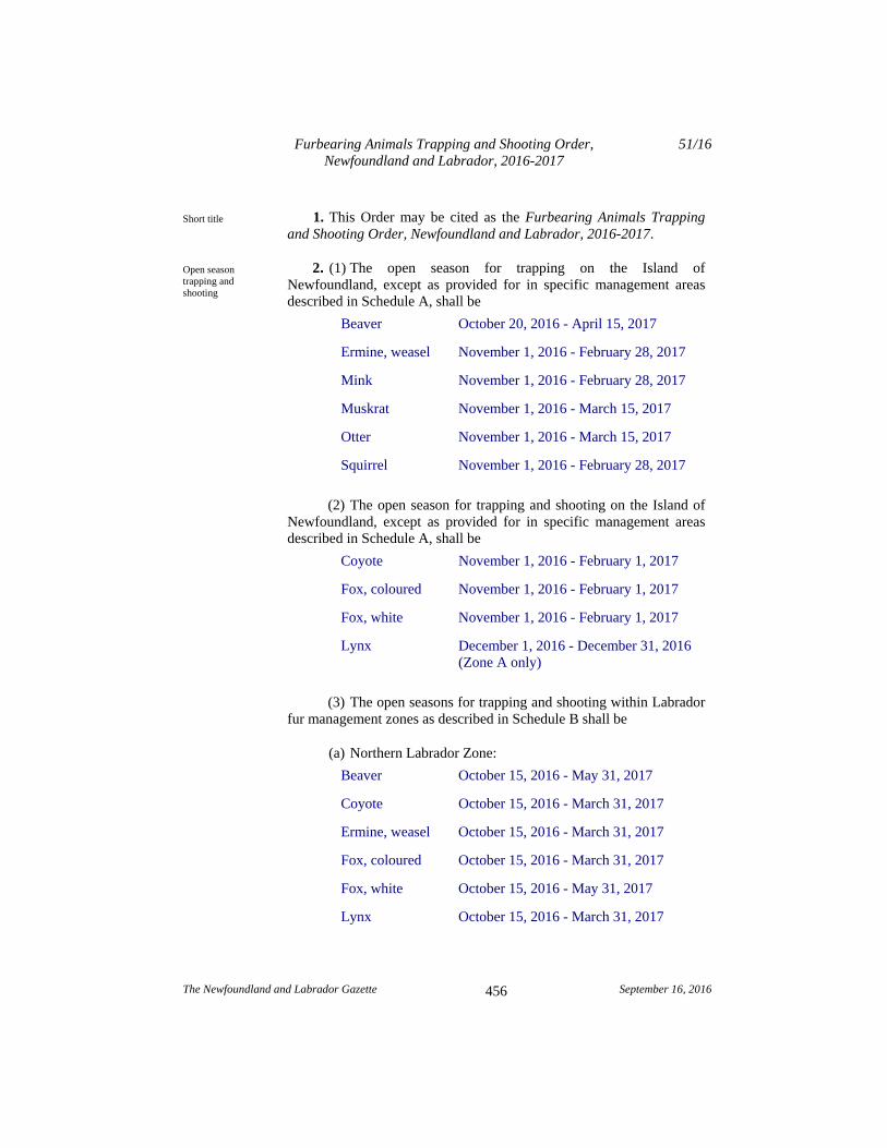
1. This Order may be cited as the Furbearing Animals Trapping and Shooting Order, Newfoundland and Labrador, 2016-2017.
2. (1) The open season for trapping on the Island of Newfoundland, except as provided for in specific management areas described in Schedule A, shall be
Beaver October 20, 2016 - April 15, 2017
Ermine, weasel November 1, 2016 - February 28, 2017
Mink November 1, 2016 - February 28, 2017
Muskrat November 1, 2016 - March 15, 2017
Otter November 1, 2016 - March 15, 2017
Squirrel November 1, 2016 - February 28, 2017
(2) The open season for trapping and shooting on the Island of Newfoundland, except as provided for in specific management areas described in Schedule A, shall be
Coyote November 1, 2016 - February 1, 2017
Fox, coloured November 1, 2016 - February 1, 2017
Fox, white November 1, 2016 - February 1, 2017
Lynx December 1, 2016 - December 31, 2016 (Zone A only)
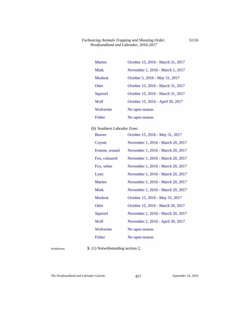
(3) The open seasons for trapping and shooting within Labrador fur management zones as described in Schedule B shall be
(a) Northern Labrador Zone:
Beaver October 15, 2016 - May 31, 2017
Coyote October 15, 2016 - March 31, 2017
Ermine, weasel October 15, 2016 - March 31, 2017
Fox, coloured October 15, 2016 - March 31, 2017
Fox, white October 15, 2016 - May 31, 2017
Lynx October 15, 2016 - March 31, 2017
Short title
Open season trapping and shooting
Furbearing Animals Trapping and Shooting Order, Newfoundland and Labrador, 2016-2017
51/16
The Newfoundland and Labrador Gazette September 16, 2016
457
Marten October 15, 2016 - March 31, 2017
Mink November 1, 2016 - March 1, 2017
Muskrat October 5, 2016 - May 31, 2017
Otter October 15, 2016 - March 31, 2017
Squirrel October 15, 2016 - March 31, 2017
Wolf October 15, 2016 - April 30, 2017
Wolverine No open season.
Fisher No open season.
(b) Southern Labrador Zone:
Beaver October 15, 2016 - May 31, 2017
Coyote November 1, 2016 - March 20, 2017
Ermine, weasel November 1, 2016 - March 20, 2017
Fox, coloured November 1, 2016 - March 20, 2017
Fox, white November 1, 2016 - March 20, 2017
Lynx November 1, 2016 - March 20, 2017
Marten November 1, 2016 - March 20, 2017
Mink November 1, 2016 - March 20, 2017
Muskrat October 15, 2016 - May 31, 2017
Otter October 15, 2016 - March 20, 2017
Squirrel November 1, 2016 - March 20, 2017
Wolf November 1, 2016 - April 30, 2017
Wolverine No open season.
Fisher No open season.
3. (1) Notwithstanding section 2, Prohibitions
Furbearing Animals Trapping and Shooting Order, Newfoundland and Labrador, 2016-2017
51/16
The Newfoundland and Labrador Gazette September 16, 2016
458
(a) the trapping and shooting of lynx is prohibited in Zone B, as described in Schedule A; and
(b) the trapping and shooting of all furbearing animals is prohibited in the following areas:
(i) Brunette Island, Fortune Bay, and
(ii) Great Southern Harbour.
(2) A person shall not use a killing trap for beaver, muskrat or marten unless the trap is a killing trap described in Schedule C for that wild life species and the trap is used in accordance with the conditions prescribed in Schedule C.
(3) A person shall not use a trap in the following areas described in Schedule A:
(a) the Pine Marten Study Area, excluding the Little Grand Lake Ecological Reserve;
(b) the Main River/Upper Humber Study Area;
(c) the Little Grand Lake Wild Life Reserve; and
(d) the Glover Island Public Reserve, Glover Island
unless the trap is a trap described in Schedule D for each furbearing species and the trap is used in accordance with the requirements of Schedule D.
(4) A person shall not use a trap in the following areas described in Schedule A:
(a) the North West Grand Lake Area;
(b) the Charlottetown Enclave Area;
(c) the Terra Nova Area; and
(d) the Red Indian Lake Area
Furbearing Animals Trapping and Shooting Order, Newfoundland and Labrador, 2016-2017
51/16
The Newfoundland and Labrador Gazette September 16, 2016
459
unless the trap is a trap described in Schedule E for each furbearing species and the trap is used in accordance with the requirements of Schedule E.
4. (1) Killing neck snares which are set on land for the purpose of taking furbearing animals shall be equipped with a noose locking device which shall be set in a manner so that the noose, once closed, is prevented from expanding.
(2) Subsection (1) shall not apply to the taking of squirrel.
5. (1) Foot hold restraining traps set for beaver, muskrat, otter and mink shall be set in a manner which allows the animal to submerge and prevent it from resurfacing.
(2) Coyote and wolf may be taken with a foot holding restraining trap providing the device has a minimum space of 5 millimetres between the jaws when closed, or the device has pads of a rubber-like substance fastened to the trap jaws or the device is equipped with trap jaws of 9 millimetres or greater in thickness.
(3) A person shall not use a foot hold restraining trap for lynx unless it is a foot hold restraining trap as described in Schedule C for lynx and the trap is used in accordance with the conditions prescribed in Schedule C.
6. (1) Furbearing animals shall be taken only by means of a killing trap set in a manner as to kill the animal quickly.
(2) Subsection (1) shall not apply to the taking of fox, coyote, wolf or lynx.
(3) A person shall not trap, take or kill any furbearing animal by means of a trap or other device equipped with metal teeth, metal serrated edges, hooks or sharp devices.
(4) A person shall not use spring poles or foot hold traps in trees or poles, unless the trap is set as a killing trap.
7. Live holding devices set on land for the taking of furbearing animals shall be checked daily.
Neck snares
Foot hold restraining traps
Killing traps
Live holding devices
Rate of beaver harvest
Furbearing Animals Trapping and Shooting Order, Newfoundland and Labrador, 2016-2017
51/16
The Newfoundland and Labrador Gazette September 16, 2016
460
8. (1) On the Island of Newfoundland, the holder of a beaver trapline licence shall harvest beaver at a rate of one beaver per active lodge on the trapline area identified in the licence.
(2) In Labrador, there is no limit on the number of beaver which may be taken by the holder of a trapper's beaver licence.
9. (1) Lynx taken during the open season for lynx shall be registered for tagging before the close of business hours on Friday, January 6, 2017.
(2) A person shall not have in his or her possession any lynx pelt or any lynx parts, unless that person holds a valid trapper's licence and the pelt or pelt parts are registered as required in subsection (1).
(3) A licensed trapper who takes lynx accidentally during the trapping seasons for other species, other than those trapping periods prescribed for lynx, shall within 7 days of the taking the lynx, surrender it to the Wildlife Division.
(4) This section shall not apply to the taking of lynx in Labrador.
10. A person who takes a wolf shall surrender the lower jawbone or complete skull of each wolf taken to the Wildlife Division by May 12, 2017.
11. A person shall not transport or possess any firearm under the authority of a valid hunting license without being in possession of an outdoor identification card, or non-resident equivalent, issued to the person.
12. Hunting with a firearm on Sundays shall be permitted across the entire province, beginning October 2, 2016 and ending April 30, 2017, for the species and during the seasons described in this Order.
13. The Furbearing Animals Trapping and Shooting Order, Newfoundland and Labrador, 2015-2016, Newfoundland and Labrador Regulation 57/15, is repealed.
Lynx
Wolves
Prohibition
Sunday hunting
Repeal
Furbearing Animals Trapping and Shooting Order, Newfoundland and Labrador, 2016-2017
51/16
The Newfoundland and Labrador Gazette September 16, 2016
461
Schedule A
(a) Pine Marten Study Area
That part of the Island of Newfoundland bounded by a line beginning at the intersection of the Trans Canada Highway, Route 1, and the Camp 33 Road;
Then following the Camp 33 Road to the southwestern extremity of Grand Lake;
Then following the shoreline of Grand Lake to the mouth of Red Indian Brook a distance of approximately 15 kilometres to a small lake on its headwaters;
Then following a straight line in a generally southeasterly direction to the southeastern extremity of the Lake of the Hills;
Then following the western bank of the brook flowing out of Lake of the Hills to Otter Pond;
Then following the western shore of Otter Pond and the western bank of the brook flowing out of Otter Pond into Lloyds River;
Then following the northern bank of Lloyds River and the northern shore of Lloyds Lake and the northern bank of Lloyds River, west of Lloyds Lake, to the mouth of the brook flowing out of Cormacks Lake;
Then following the eastern or northern bank of this brook to Cormacks Lake;
Then following a straight line in a generally northerly direction approximately 8 kilometres to a point on the headwaters of Little Barachois Brook;
Then following the northern bank of Little Barachois Brook to its intersection with the eastern boundary of the Barachois Pond Provincial Park;
Furbearing Animals Trapping and Shooting Order, Newfoundland and Labrador, 2016-2017
51/16
The Newfoundland and Labrador Gazette September 16, 2016
462
Then following the eastern and northern boundaries of the park to the Trans Canada Highway;
Then following the Trans Canada Highway to the point of commencement.
Excluding the Little Grand Lake Provisional Ecological Reserve established by the Little Grand Lake Provisional Ecological Reserve Regulations, Newfoundland and Labrador Regulation 84/02, as described in the Little Grand Lake Provisional Ecological Reserve Order, Newfoundland and Labrador Regulation 83/02, made under the authority of the Wilderness and Ecological Reserves Act.
(b) Main River/Upper Humber Area
All that area of the Island of Newfoundland, commencing at a tributary on Main River UTM 481,975 metres east 5,522,600 metres north;
Then following this tributary in a generally northerly direction to UTM 483,840 metres east 5,528,225 metres north;
Then following a straight line in a southeasterly direction to UTM 488,460 metres east 5,525,000 metres north;
Then following a straight line in an easterly direction to the eastern extremity of a small pond at UTM 498,485 metres east 5,525,000 metres north;
Then following the eastern shoreline of the pond to its outlet;
Then following a chain of brooks in a southerly direction to UTM 498,771 metres east 5,522,615 metres north;
Then following a straight line in a generally southeasterly direction to UTM 502,332 metres east 5,518,590 metres north;
Furbearing Animals Trapping and Shooting Order, Newfoundland and Labrador, 2016-2017
51/16
The Newfoundland and Labrador Gazette September 16, 2016
463
Then following a straight line in a generally southwesterly direction to UTM 499,538 metres east 5,516,260 metres north;
Then following a straight line in a southerly direction to the outlet of a small pond at UTM 499,615 metres east 5,513,620 metres north;
Then following a stream that flows in a southerly direction to Main River;
Then following Main River in a westerly direction to a small tributary at UTM 495,570 metres east 5,510,540 metres north;
Then following that tributary and a chain of ponds in a generally westerly direction to where a small stream is intersected by the Upper Humber Forest Access Road at UTM 480,650 metres east 5,509,735 metres north;
Then following a straight line in a westerly direction to the east shore of a small pond at UTM 469,023 metres east 5,510,070 metres north;
Then following the north side of that pond and a connected tributary in a northwesterly direction to its intersection with the eastern boundary of Gros Morne National Park at UTM 466,335 metres east 5,510,602 metres north;
Then following the boundary of the park in a northerly direction to where it intersections a lake at UTM 461,750 metres east 5,529,000 metres north;
Then following the south shoreline of that lake in an easterly direction to its most eastern extremity;
Then following a straight line in an easterly direction to UTM 466,087 metres east 5,528,540 metres north;
Then following the southern shore of Parsons Pond River in an easterly direction to the point of commencement.
(c) Northwest Grand Lake Area
Furbearing Animals Trapping and Shooting Order, Newfoundland and Labrador, 2016-2017
51/16
The Newfoundland and Labrador Gazette September 16, 2016
464
All that area of the Island of Newfoundland bounded by a line beginning at the intersection of the Trans Canada Highway, Route 1, and Camp 33 Road;
Then following Camp 33 Road to the southwest extremity of Grand Lake;
Then following the north shoreline of Grand Lake in a northeasterly direction to the Humber Canal;
Then following the south bank of the Humber Canal to its intersection with the TCH at Deer Lake;
Then following the TCH in a southwesterly direction to the point of commencement.
(d) Terra Nova Area
All that area of the Island of Newfoundland bounded by a line beginning at the intersection of North West River and the Terra Nova National Park, TNNP, boundary at UTM coordinates 706,250 metres east and 5,365,250 metres north;
Then following the north bank of the said river in a westerly direction to UTM coordinates 664,125 metres east and 5,346,625 metres north;
Then following a straight line in a northwesterly direction to UTM coordinates 663,750 metres east and 5,353,125 metres north;
Then following a straight line in a westerly direction to the northeastern extremity of Kepenkeck Lake;
Then following a straight line in a northwesterly direction to the eastern extremity of Newton's Lake;
Then following a straight line in a northerly direction to the eastern extremity of South West Pond;
Then following a straight line in a northeasterly direction to the western extremity of Dead Wolf Pond;
Furbearing Animals Trapping and Shooting Order, Newfoundland and Labrador, 2016-2017
51/16
The Newfoundland and Labrador Gazette September 16, 2016
465
Then following the southern shoreline of Dead Wolf Pond to the mouth of a small stream entering the pond at its eastern extremity;
Then following this stream to its headwaters pond;
Then following a straight line for approximately 500 metres due east to an unnamed pond;
Then following a stream exiting this pond at its southeastern extremity;
Then following this stream in a southeasterly direction to its outflow in Riverhead Brook;
Then following this brook in an easterly direction to its mouth in Gambo Pond;
Then following the north shore of Gambo Pond to Gambo Brook;
Then following the west bank of Gambo Brook to its intersection with the Trans Canada Highway, TCH, Route l;
Then following the TCH in an easterly direction to its intersection with the TNNP boundary;
Then following the western boundary of TNNP in a southerly direction to the point of commencement.
(e) Charlottetown Enclave Area
All that area of the Island of Newfoundland bounded by a line beginning at the intersection of the Terra Nova National Park, TNNP, boundary and the north shoreline of Clode Sound, Bonavista Bay at UTM coordinates 720,554 metres east and 5,367,279 metres north;
Then following the TNNP boundary in a northerly direction to UTM coordinates 720,507 metres east and 5,370,209 metres north;
Furbearing Animals Trapping and Shooting Order, Newfoundland and Labrador, 2016-2017
51/16
The Newfoundland and Labrador Gazette September 16, 2016
466
Then following the TNNP boundary in a northeasterly direction to UTM coordinates 721,554 metres east and 5,371,792 metres north;
Then following the TNNP boundary in a southeasterly direction to its intersection with the north shoreline of Clode Sound, Bonavista Bay at UTM coordinates 722,550 metres east and 5,369,850 metres north;
Then following the shoreline of Clode Sound, Bonavista Bay in a southwesterly direction to the point of commencement.
(f) Red Indian Lake Area
All that area of the Island of Newfoundland bounded by a line beginning at the mouth of Victoria River and Red Indian Lake;
Then following the north bank of Victoria River in a southwesterly direction to Victoria Lake;
Then following a mid-way line between the north and south shorelines of Victoria Lake to the mouth of a small river entering Victoria Lake at its southwestern extremity;
Then following the north bank of the Victoria River to a point opposite the mouth of a brook flowing from Peter Strides Pond;
Then following a straight line in a northerly direction to the intersection of the Pine Marten Study Area and Lloyds River at the mouth of the brook flowing from Cormack Lake;
Then following the Pine Marten Study Area boundary along Lloyds River in a northeasterly direction to the mouth of Otter Pond Brook;
Then following the western bank of Otter Pond Brook, the western shore of Otter Pond and the west bank of Otter Pond Brook to Lake of the Hills;
Furbearing Animals Trapping and Shooting Order, Newfoundland and Labrador, 2016-2017
51/16
The Newfoundland and Labrador Gazette September 16, 2016
467
Then following a straight line in a northwesterly direction to UTM co-ordinates 471,250 metres east and 5,379,000 metres north;
Then following a straight line in a northeasterly direction to its intersection with Clench Brook at UTM co-ordinates 500,875 metres east and 5,401,000 metres north;
Then following the south bank of Clench Brook to its mouth on Red Indian Lake;
Then following a straight line in an easterly direction to the point of commencement.
(g) Lynx Zone A: Northern Region (Open)
All that area of the Island of Newfoundland bounded by a line beginning at the intersection of the Burgeo Highway with the southern bank of Lloyds River and;
Then following the Burgeo Highway in a southerly direction to the northern extent of the intersection of the causeway to Grandy Island and the coastline of Insular Newfoundland;
Then following the coastline in generally westerly direction to Cape Ray;
Then following the coastline in a generally north-westerly direction to cape Anguille;
Then following along the western shoreline of Insular Newfoundland and western shoreline of the Great Northern Peninsula, excluding all areas within the jurisdiction of Gros Morne National Park, to Cape Onion;
Then following a generally south westerly direction along the eastern shoreline of the Great Northern Peninsula to the confluence of Hampton River with White Bay;
Then following the north east coast of insular Newfoundland in a generally easterly direction to the mouth of the Terra Nova River at its outflow located at Glovertown South;

Furbearing Animals Trapping and Shooting Order, Newfoundland and Labrador, 2016-2017
51/16
The Newfoundland and Labrador Gazette September 16, 2016
468
Then following the southern bank of the Terra Nova River to its confluence with Terra Nova Lake;
Then following the southern shoreline of Terra Nova Lake in a generally south westerly direction to its southern extremity;
Then following the southern bank of the Terra Nova River in a generally south westerly direction to Mollyguajeck Lake;
Then following the south eastern shoreline of Mollyguajeck Lake to its southern extremity where a small stream enters the lake;
Then following a straight line in a westerly direction to the point of commencement.
(h) Lynx Zone B: Southern Region
All that area of the Island of Newfoundland bounded by a line beginning at the intersection of the Burgeo Highway and the south bank of Llyods River;
Then following a straight line in an easterly direction to the southern extremity of Mollyguajeck Lake where a small stream enters the lake;
Then following the southern shoreline of Mollyguajeck Lake to Terra Nova River;
Then following the southern bank of the Terra Nova River to Terra Nova Lake;
Then following the southern shoreline of Terra Nova Lake to its eastern most extremity where it Terra Nova River;
Then following the southern bank of the Terra Nova River to its outflow located at Glovertown South;
Then following the coastline of insular Newfoundland including all offshore islands and excluding all areas within National Park jurisdiction in southerly direction to the
Furbearing Animals Trapping and Shooting Order, Newfoundland and Labrador, 2016-2017
51/16
The Newfoundland and Labrador Gazette September 16, 2016
469
northern extent of the intersection of the coastline of Insular Newfoundland and the causeway to Grandy Island;
Then following the Burgeo Highway in a northerly direction to the point of commencement.
(i) Little Grand Lake Wild Life Reserve
The Little Grand Lake Wild Life Reserve established by the Little Grand Lake Wild Life Reserve Regulations, Newfoundland and Labrador Regulation 85/02.
(j) Glover Island
The Glover Island Public Reserve established by the Glover Island Public Reserve Regulations, Newfoundland and Labrador Regulation 87/02, as described in the Glover Island Public Reserve Order, 2013, Newfoundland and Labrador Regulation 123/13, made under the authority of the Lands Act.
Furbearing Animals Trapping and Shooting Order, Newfoundland and Labrador, 2016-2017
51/16
The Newfoundland and Labrador Gazette September 16, 2016
470
Schedule B
(a) Labrador North Fur Zone
All that area of Labrador, including offshore islands, lying north of a line commencing at a point on the coast at 54 north latitude;
Then following a line due west to its intersection with 62 west longitude;
Then following a line due north to its intersection with 55 north latitude;
Then following a line due west along 55 north latitude to its intersection with the Labrador-Quebec border;
Then following the Labrador-Quebec border in a generally northerly direction to Cape Chidley;
Then following the coastline of Labrador in a generally south easterly direction to the point on the coast at 54 north latitude, the point of commencement.
(b) Labrador South Fur Zone
All that area of Labrador, including offshore islands, lying south of a line commencing at a point on the coast at 54 north latitude;
Then following a line due west to its intersection with 62 west longitude;
Then following a line due north to its intersection with 55 north latitude;
Then following a line due west along 55 north latitude to its intersection with the Labrador-Quebec border;
Then following the Labrador-Quebec border in a generally southerly direction, then easterly direction to the coast of Labrador;
Furbearing Animals Trapping and Shooting Order, Newfoundland and Labrador, 2016-2017
51/16
The Newfoundland and Labrador Gazette September 16, 2016
471
Then following the coastline of Labrador in a generally north westerly direction to the point on the coast at 54 north latitude, the point of commencement.
Furbearing Animals Trapping and Shooting Order, Newfoundland and Labrador, 2016-2017
51/16
The Newfoundland and Labrador Gazette September 16, 2016
472
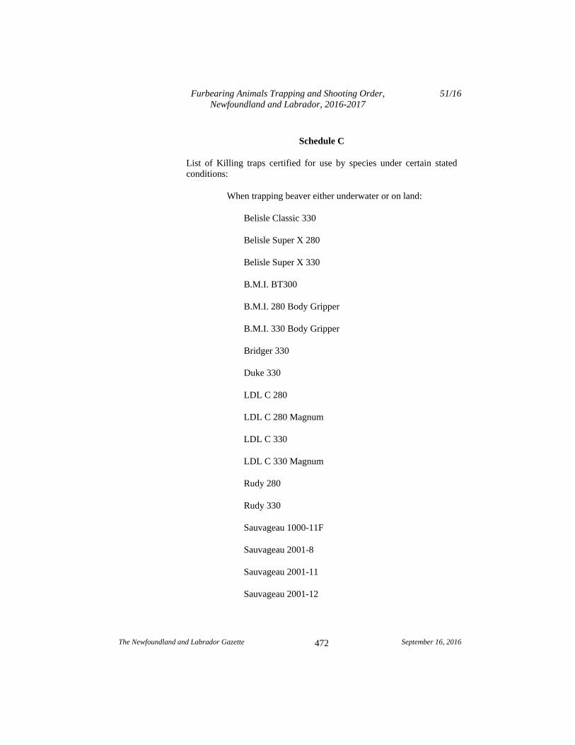
Schedule C
List of Killing traps certified for use by species under certain stated conditions:
When trapping beaver either underwater or on land:
Belisle Classic 330
Belisle Super X 280
Belisle Super X 330
B.M.I. BT300
B.M.I. 280 Body Gripper
B.M.I. 330 Body Gripper
Bridger 330
Duke 330
LDL C 280
LDL C 280 Magnum
LDL C 330
LDL C 330 Magnum
Rudy 280
Rudy 330
Sauvageau 1000-11F
Sauvageau 2001-8
Sauvageau 2001-11
Sauvageau 2001-12
Furbearing Animals Trapping and Shooting Order, Newfoundland and Labrador, 2016-2017
51/16
The Newfoundland and Labrador Gazette September 16, 2016
473
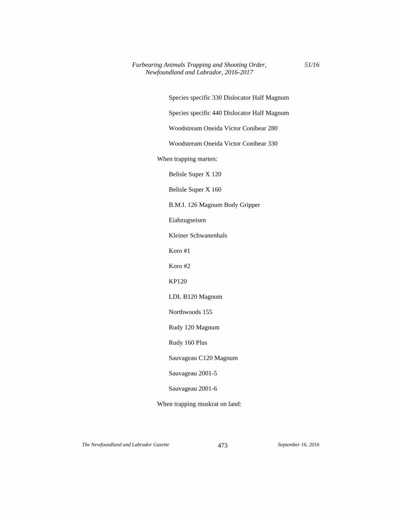
Species specific 330 Dislocator Half Magnum
Species specific 440 Dislocator Half Magnum
Woodstream Oneida Victor Conibear 280
Woodstream Oneida Victor Conibear 330
When trapping marten:
Belisle Super X 120
Belisle Super X 160
B.M.I. 126 Magnum Body Gripper
Eiabzugseisen
Kleiner Schwanenhals
Koro #1
Koro #2
KP120
LDL B120 Magnum
Northwoods 155
Rudy 120 Magnum
Rudy 160 Plus
Sauvageau C120 Magnum
Sauvageau 2001-5
Sauvageau 2001-6
When trapping muskrat on land:

Furbearing Animals Trapping and Shooting Order, Newfoundland and Labrador, 2016-2017
51/16
The Newfoundland and Labrador Gazette September 16, 2016
474
Belisle Super X 110
Belisle Super X 120
B.M.I. 120
B.M.I. 120 Magnum
B.M.I. 126 Magnum
Bridger 120
Duke 120
Koro Muskrat
LDL B120
LDL B120 Magnum
Ouell RM
Ouell 411-180
Rudy 110
Rudy 120
Rudy 120 Magnum
Sauvageau C120 Magnum
Sauvageau C120 "Reverse Bend"
Sauvageau 2001-5
Triple M
Woodstream Oneida Victor Conibear 110
Woodstream Oneida Victor Conibear 120
Furbearing Animals Trapping and Shooting Order, Newfoundland and Labrador, 2016-2017
51/16
The Newfoundland and Labrador Gazette September 16, 2016
475
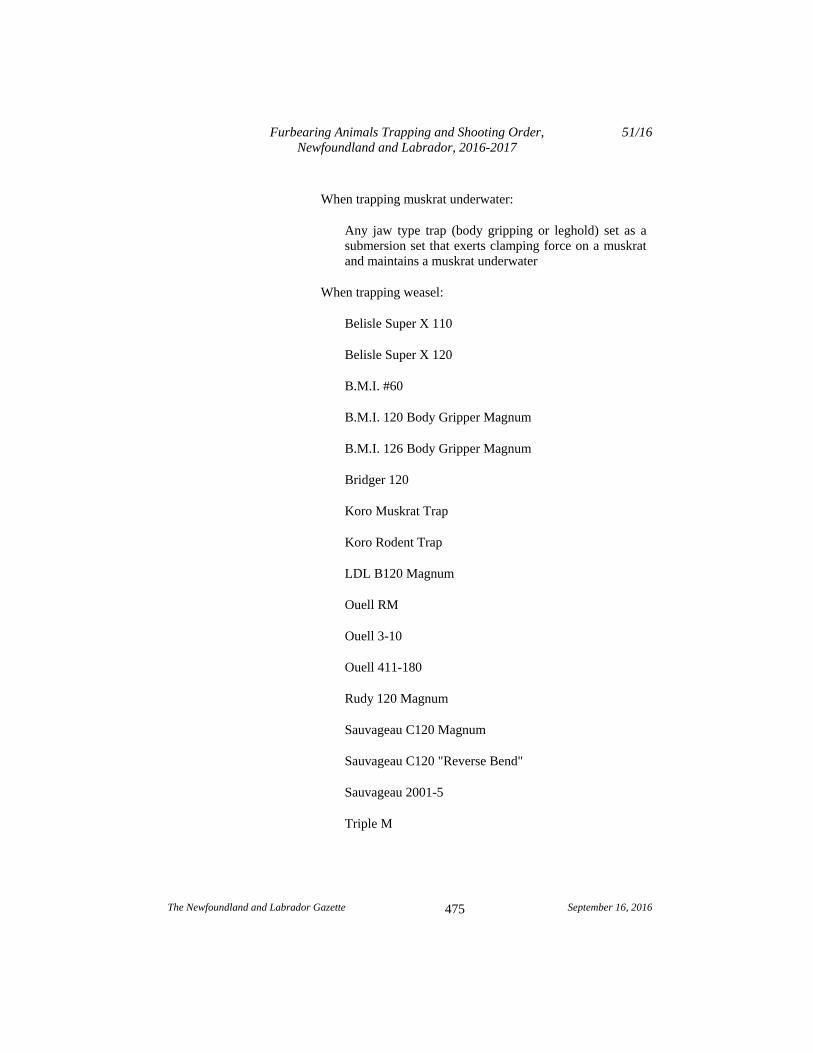
When trapping muskrat underwater:
Any jaw type trap (body gripping or leghold) set as a submersion set that exerts clamping force on a muskrat and maintains a muskrat underwater
When trapping weasel:
Belisle Super X 110
Belisle Super X 120
B.M.I. #60
B.M.I. 120 Body Gripper Magnum
B.M.I. 126 Body Gripper Magnum
Bridger 120
Koro Muskrat Trap
Koro Rodent Trap
LDL B120 Magnum
Ouell RM
Ouell 3-10
Ouell 411-180
Rudy 120 Magnum
Sauvageau C120 Magnum
Sauvageau C120 "Reverse Bend"
Sauvageau 2001-5
Triple M
Furbearing Animals Trapping and Shooting Order, Newfoundland and Labrador, 2016-2017
51/16
The Newfoundland and Labrador Gazette September 16, 2016
476
Victor Rat Trap
Woodstream Oneida Victor Conibear 110
Woodstream Oneida Victor Conibear 120
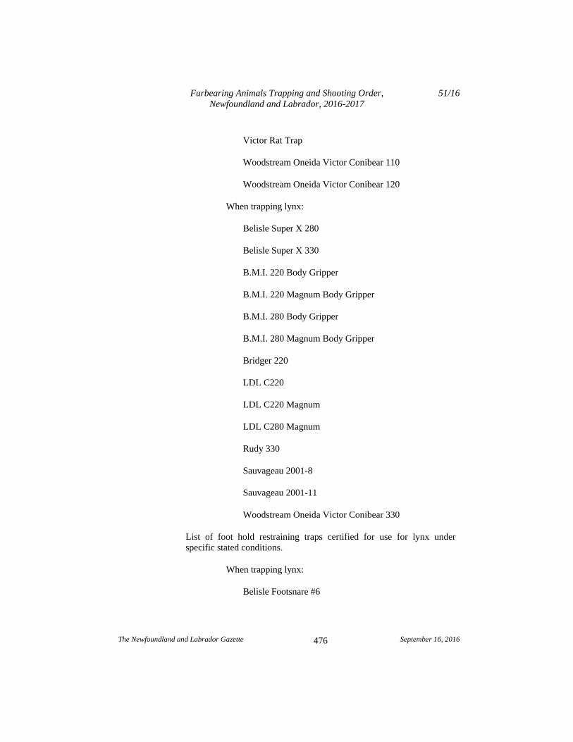
When trapping lynx:
Belisle Super X 280
Belisle Super X 330
B.M.I. 220 Body Gripper
B.M.I. 220 Magnum Body Gripper
B.M.I. 280 Body Gripper
B.M.I. 280 Magnum Body Gripper
Bridger 220
LDL C220
LDL C220 Magnum
LDL C280 Magnum
Rudy 330
Sauvageau 2001-8
Sauvageau 2001-11
Woodstream Oneida Victor Conibear 330
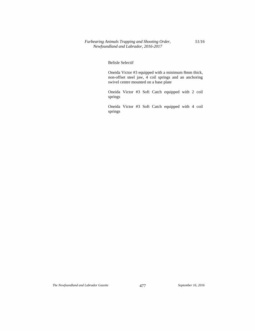
List of foot hold restraining traps certified for use for lynx under specific stated conditions.
When trapping lynx:
Belisle Footsnare #6
Furbearing Animals Trapping and Shooting Order, Newfoundland and Labrador, 2016-2017
51/16
The Newfoundland and Labrador Gazette September 16, 2016
477
Belisle Selectif
Oneida Victor #3 equipped with a minimum 8mm thick, non-offset steel jaw, 4 coil springs and an anchoring swivel centre mounted on a base plate
Oneida Victor #3 Soft Catch equipped with 2 coil springs
Oneida Victor #3 Soft Catch equipped with 4 coil springs
Furbearing Animals Trapping and Shooting Order, Newfoundland and Labrador, 2016-2017
51/16
The Newfoundland and Labrador Gazette September 16, 2016
478
Schedule D
Trapping and setting requirements by species approved for use in the Main River/Upper Humber Study Area, Pine Marten Study Area (Excluding the Little Grand Lake Provisional Ecological Reserve), the Little Grand Lake Wild Life Reserve and the Glover Island Public Reserve.
Target Species and Approved Trap
Setting Requirements
Beaver Conibear Trap jaws shall be completely submerged requiring target species to dive.
Beaver Submarine Cage
Cage shall be completely submerged.
Beaver Snare Pole
Snares shall be completely submerged.
Ermine (weasel) or Squirrel Rat Trap
Victor rat trap, whether baited or not, shall be completely enclosed inside a wooden box with a 1.5" hole at one end.
Fox , Coyote or Lynx Restraining Neck Snare
- Wire shall be 3/32 " or greater - 360 swivel required at the attachment point - The stop on the snare loop shall be fastened so that the loop will close to a minimum 8" circumference. - The snare shall be fastened to an immovable object with no drags. - The snare may be set with or without the use of bait.
Mink Conibear The floating mink box-trap shall be set in the entrance of a floating wooden box, whether or not the trap is baited, and the entrance to the box shall be completely submerged.
Otter, Mink or Muskrat Submarine Cage
The cage shall be completely submerged.
Furbearing Animals Trapping and Shooting Order, Newfoundland and Labrador, 2016-2017
51/16
The Newfoundland and Labrador Gazette September 16, 2016
479
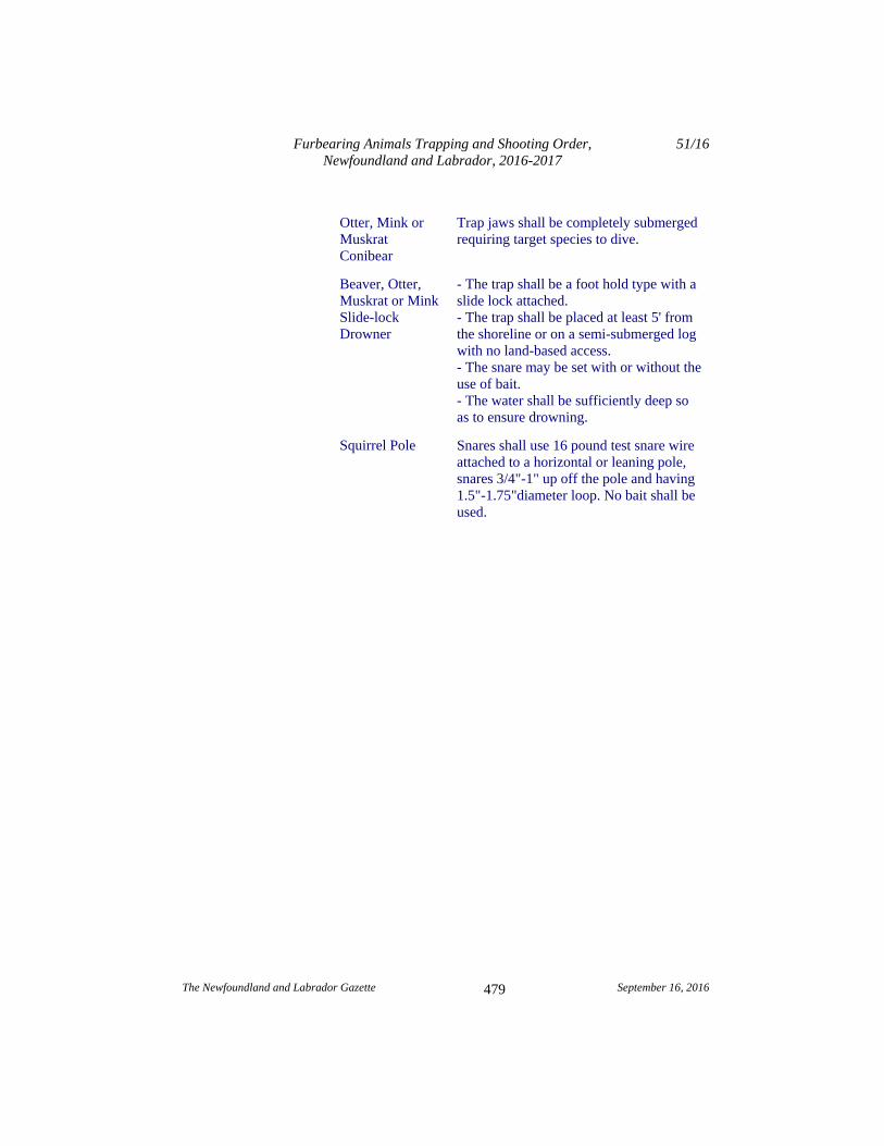
Otter, Mink or Muskrat Conibear
Trap jaws shall be completely submerged requiring target species to dive.
Beaver, Otter, Muskrat or Mink Slide-lock Drowner
- The trap shall be a foot hold type with a slide lock attached. - The trap shall be placed at least 5' from the shoreline or on a semi-submerged log with no land-based access. - The snare may be set with or without the use of bait. - The water shall be sufficiently deep so as to ensure drowning.
Squirrel Pole Snares shall use 16 pound test snare wire attached to a horizontal or leaning pole, snares 3/4"-1" up off the pole and having 1.5"-1.75"diameter loop. No bait shall be used.
Furbearing Animals Trapping and Shooting Order, Newfoundland and Labrador, 2016-2017
51/16
The Newfoundland and Labrador Gazette September 16, 2016
480
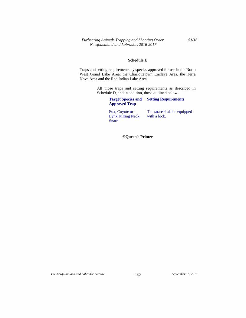
Schedule E
Traps and setting requirements by species approved for use in the North West Grand Lake Area, the Charlottetown Enclave Area, the Terra Nova Area and the Red Indian Lake Area.
All those traps and setting requirements as described in Schedule D, and in addition, those outlined below:
Target Species and Approved Trap
Setting Requirements
Fox, Coyote or Lynx Killing Neck Snare
The snare shall be equipped with a lock.
©Queen's Printer
The Newfoundland and Labrador Gazette September 16, 2016
481
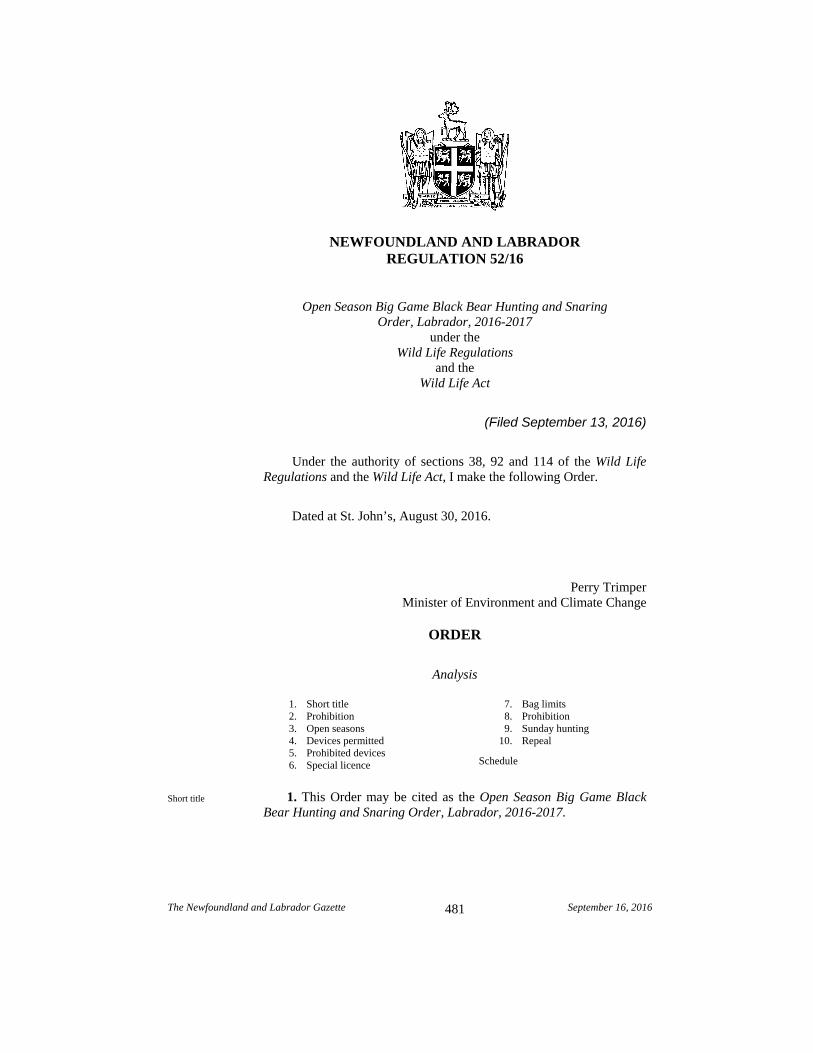
NEWFOUNDLAND AND LABRADOR REGULATION 52/16
Open Season Big Game Black Bear Hunting and Snaring Order, Labrador, 2016-2017
under the Wild Life Regulations
and the Wild Life Act
(Filed September 13, 2016)
Under the authority of sections 38, 92 and 114 of the Wild Life Regulations and the Wild Life Act, I make the following Order.
Dated at St. John’s, August 30, 2016.
Perry Trimper Minister of Environment and Climate Change
ORDER
Analysis
1. Short title 2. Prohibition 3. Open seasons 4. Devices permitted 5. Prohibited devices 6. Special licence
7. Bag limits 8. Prohibition 9. Sunday hunting 10. Repeal
Schedule
1. This Order may be cited as the Open Season Big Game Black Bear Hunting and Snaring Order, Labrador, 2016-2017.
Short title
Open Season Big Game Black Bear Hunting and Snaring Order, Labrador, 2016-2017
52/16
The Newfoundland and Labrador Gazette September 16, 2016
482
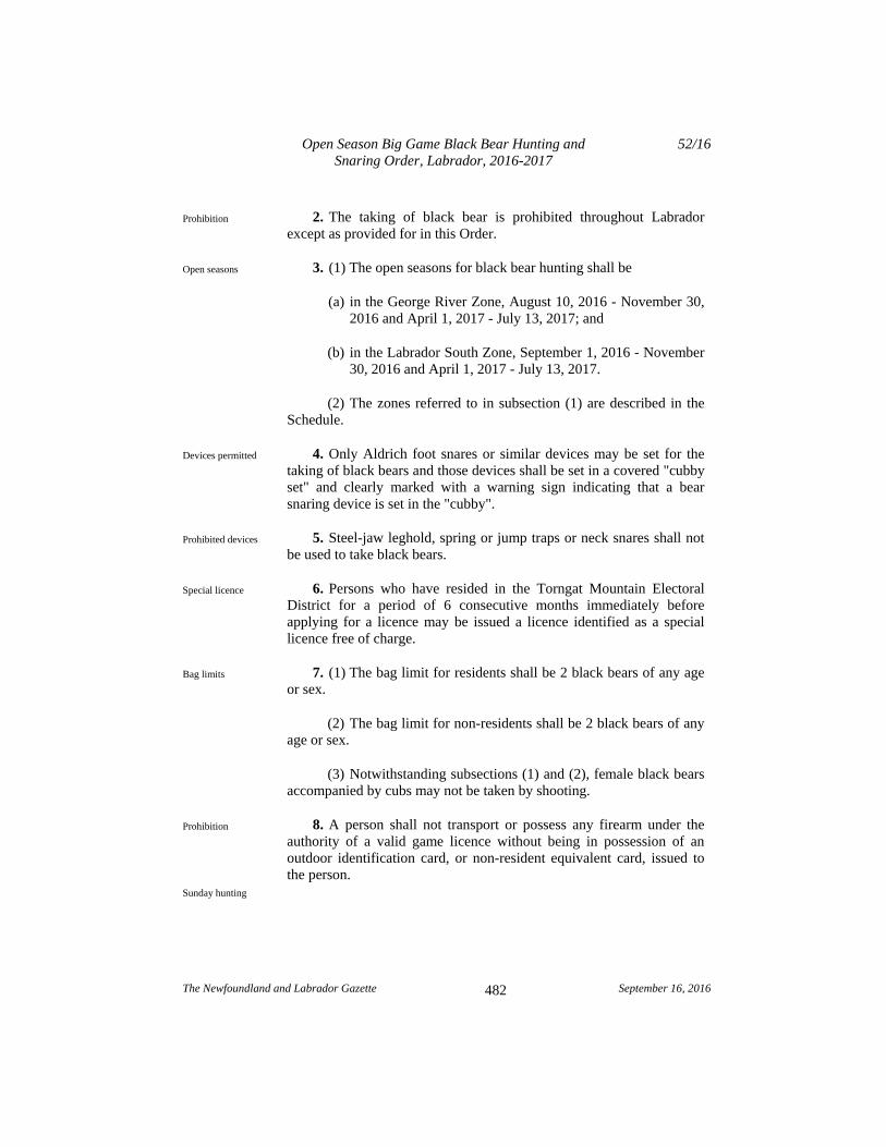
2. The taking of black bear is prohibited throughout Labrador except as provided for in this Order.
3. (1) The open seasons for black bear hunting shall be
(a) in the George River Zone, August 10, 2016 - November 30, 2016 and April 1, 2017 - July 13, 2017; and
(b) in the Labrador South Zone, September 1, 2016 - November 30, 2016 and April 1, 2017 - July 13, 2017.
(2) The zones referred to in subsection (1) are described in the Schedule.
4. Only Aldrich foot snares or similar devices may be set for the taking of black bears and those devices shall be set in a covered "cubby set" and clearly marked with a warning sign indicating that a bear snaring device is set in the "cubby".
5. Steel-jaw leghold, spring or jump traps or neck snares shall not be used to take black bears.
6. Persons who have resided in the Torngat Mountain Electoral District for a period of 6 consecutive months immediately before applying for a licence may be issued a licence identified as a special licence free of charge.
7. (1) The bag limit for residents shall be 2 black bears of any age or sex.
(2) The bag limit for non-residents shall be 2 black bears of any age or sex.
(3) Notwithstanding subsections (1) and (2), female black bears accompanied by cubs may not be taken by shooting.
8. A person shall not transport or possess any firearm under the authority of a valid game licence without being in possession of an outdoor identification card, or non-resident equivalent card, issued to the person.
Prohibition
Open seasons
Devices permitted
Prohibited devices
Special licence
Bag limits
Prohibition
Sunday hunting
Open Season Big Game Black Bear Hunting and Snaring Order, Labrador, 2016-2017
52/16
The Newfoundland and Labrador Gazette September 16, 2016
483
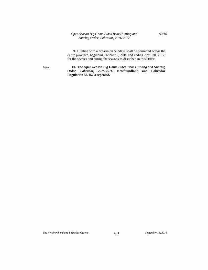
9. Hunting with a firearm on Sundays shall be permitted across the entire province, beginning October 2, 2016 and ending April 30, 2017, for the species and during the seasons as described in this Order.
10. The Open Season Big Game Black Bear Hunting and Snaring Order, Labrador, 2015-2016, Newfoundland and Labrador Regulation 58/15, is repealed.
Repeal
Open Season Big Game Black Bear Hunting and Snaring Order, Labrador, 2016-2017
52/16
The Newfoundland and Labrador Gazette September 16, 2016
484
Schedule
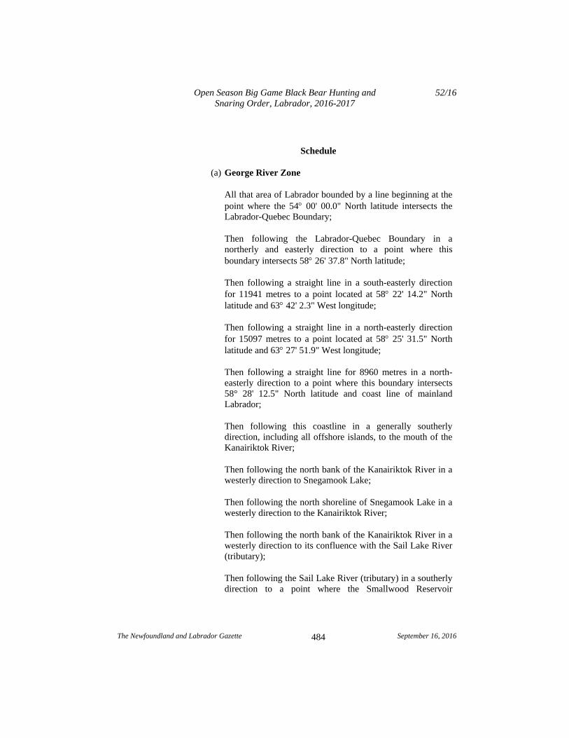
(a) George River Zone
All that area of Labrador bounded by a line beginning at the point where the 54 00' 00.0" North latitude intersects the Labrador-Quebec Boundary;
Then following the Labrador-Quebec Boundary in a northerly and easterly direction to a point where this boundary intersects 58 26' 37.8" North latitude;
Then following a straight line in a south-easterly direction for 11941 metres to a point located at 58 22' 14.2" North latitude and 63 42' 2.3" West longitude;
Then following a straight line in a north-easterly direction for 15097 metres to a point located at 58 25' 31.5" North latitude and 63 27' 51.9" West longitude;
Then following a straight line for 8960 metres in a north-easterly direction to a point where this boundary intersects 58° 28' 12.5" North latitude and coast line of mainland Labrador;
Then following this coastline in a generally southerly direction, including all offshore islands, to the mouth of the Kanairiktok River;
Then following the north bank of the Kanairiktok River in a westerly direction to Snegamook Lake;
Then following the north shoreline of Snegamook Lake in a westerly direction to the Kanairiktok River;
Then following the north bank of the Kanairiktok River in a westerly direction to its confluence with the Sail Lake River (tributary);
Then following the Sail Lake River (tributary) in a southerly direction to a point where the Smallwood Reservoir
Open Season Big Game Black Bear Hunting and Snaring Order, Labrador, 2016-2017
52/16
The Newfoundland and Labrador Gazette September 16, 2016
485
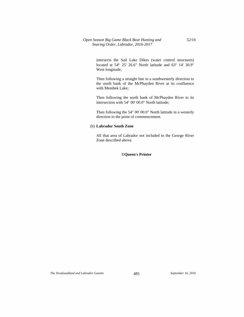
intersects the Sail Lake Dikes (water control structures) located at 54 25' 26.6" North latitude and 63 14' 30.9" West longitude;
Then following a straight line in a southwesterly direction to the north bank of the McPhayden River at its confluence with Menihek Lake;
Then following the north bank of McPhayden River to its intersection with 54 00' 00.0" North latitude;
Then following the 54 00' 00.0" North latitude in a westerly direction to the point of commencement.
(b) Labrador South Zone
All that area of Labrador not included in the George River Zone described above.
©Queen's Printer

The Newfoundland and Labrador Gazette September 16, 2016
487
NEWFOUNDLAND AND LABRADOR REGULATION 53/16
Open Season Big Game Caribou Hunting Order, Newfoundland, 2016-2017
under the Wild Life Regulations
and the Wild Life Act
(Filed September 13, 2016)
Under the authority of sections 38 and 114 of the Wild Life Regulations and the Wild Life Act, I make the following Order.
Dated at St. John’s, August 30, 2016.
Perry Trimper Minister of Environment and Climate Change
ORDER
Analysis
1. Short title 2. Hunting prohibited 3. Caribou management areas 4. Open seasons 5. Bag limit
6. Prohibition 7. Sunday hunting 8. Repeal
Schedule
1. This Order may be cited as the Open Season Big Game Caribou Hunting Order, Newfoundland, 2016-2017.
2. The hunting of caribou is prohibited throughout the Island of Newfoundland, except as provided for in this Order.
Short title
Hunting prohibited
Open Season Big Game Caribou Hunting Order, Newfoundland, 2016-2017
53/16
The Newfoundland and Labrador Gazette September 16, 2016
488
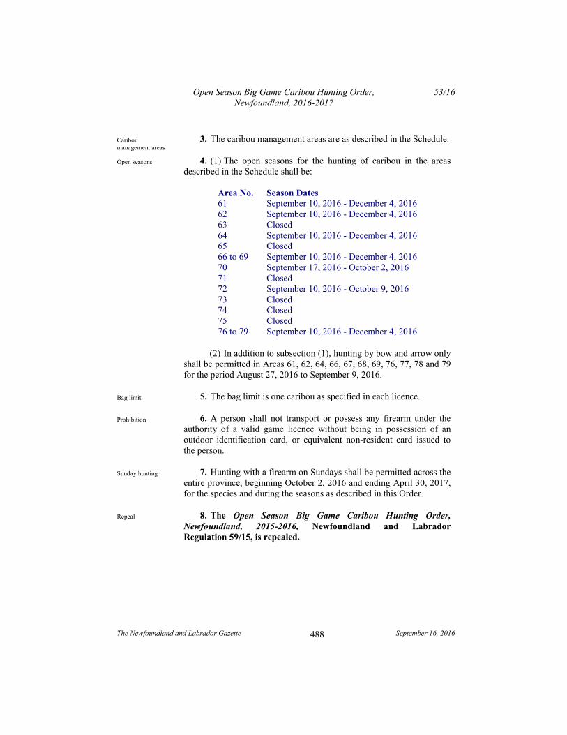
3. The caribou management areas are as described in the Schedule.
4. (1) The open seasons for the hunting of caribou in the areas described in the Schedule shall be:
Area No. Season Dates 61 September 10, 2016 - December 4, 2016 62 September 10, 2016 - December 4, 2016 63 Closed 64 September 10, 2016 - December 4, 2016 65 Closed 66 to 69 September 10, 2016 - December 4, 2016 70 September 17, 2016 - October 2, 2016 71 Closed 72 September 10, 2016 - October 9, 2016 73 Closed 74 Closed 75 Closed 76 to 79 September 10, 2016 - December 4, 2016
(2) In addition to subsection (1), hunting by bow and arrow only shall be permitted in Areas 61, 62, 64, 66, 67, 68, 69, 76, 77, 78 and 79 for the period August 27, 2016 to September 9, 2016.
5. The bag limit is one caribou as specified in each licence.
6. A person shall not transport or possess any firearm under the authority of a valid game licence without being in possession of an outdoor identification card, or equivalent non-resident card issued to the person.
7. Hunting with a firearm on Sundays shall be permitted across the entire province, beginning October 2, 2016 and ending April 30, 2017, for the species and during the seasons as described in this Order.
8. The Open Season Big Game Caribou Hunting Order, Newfoundland, 2015-2016, Newfoundland and Labrador Regulation 59/15, is repealed.
Caribou management areas
Open seasons
Bag limit
Prohibition
Sunday hunting
Repeal
Open Season Big Game Caribou Hunting Order, Newfoundland, 2016-2017
53/16
The Newfoundland and Labrador Gazette September 16, 2016
489
Schedule
(a) Area 61 - LaPoile
All that area of the Island of Newfoundland bounded by a line beginning at the southeast branch of Southwest Brook at UTM coordinates 421,602 metres east and 5,371,355 metres north;
Then following a straight line in a southeasterly direction to the outflow of a brook into the eastern extremity of Cormacks Lake at UTM coordinates 437,534 metres east and 5,348,133 metres north;
Then following a straight line in a southwesterly direction to King George IV Lake at the start of Lloyds River at UTM coordinates 435,714 metres east and 5,341,543 metres north;
Then following the southeastern bank of Lloyds River in a northeasterly direction to its confluence with Lloyds Lake;
Then following a straight line in a southeasterly direction to an unnamed river at the southwestern extremity of Victoria Lake Reservoir at UTM coordinates 467,058 metres east and 5,340,999 metres north;
Then following the northern bank of this unnamed river in a generally westerly direction to the western extremity of a pond at UTM coordinates 456,952 metres east and 5,338,821 metres north;
Then following a straight line in a northwesterly direction to a brook at the northeastern extremity of Peter Stride's Pond;
Then following the northern shoreline of said pond in a southwesterly direction to its intersection with the Burgeo Highway;
Then following the Burgeo Highway in a southeasterly direction to its intersection with Burnt Pond River;
Open Season Big Game Caribou Hunting Order, Newfoundland, 2016-2017
53/16
The Newfoundland and Labrador Gazette September 16, 2016
490
Then following the northern bank of said river in a northeasterly direction to its confluence with Spruce Pond;
Then following the northern shoreline of Spruce Pond to a brook at its eastern extremity at UTM coordinates 461,849 metres east and 5,329,219 metres north;
Then following the eastern bank of this brook in a southerly direction to its confluence with an unnamed pond;
Then following the northern and eastern shorelines of said pond in a southeasterly direction to UTM coordinates 462,747 metres east and 5,328,615 metres north;
Then following a straight line in a southeasterly direction to where an unnamed river enters an unnamed pond at UTM coordinates 467,193 metres east and 5,311,908 metres north;
Then following the south bank of this unnamed river in a generally southerly, then southeasterly direction to its confluence with White Bear River at UTM coordinates 476,815 metres east and 5,308,977 metres north;
Then following the western bank of White Bear River in a generally southerly direction to its confluence with White Bear Bay;
Then following the coastline of White Bear Bay in a generally southerly direction to Northwest Head;
Then following the coastline of insular Newfoundland in a generally westerly direction to the northern abutment of the Trans Canada Highway, TCH bridge crossing near Channel-Port aux Basques;
Then following the TCH in a generally northwesterly, then northeasterly direction to the northern abutment of the bridge crossing Southwest Brook;
Then following the northern bank of Southwest Brook in an easterly direction to the point of commencement;
Excluding all offshore islands.
Open Season Big Game Caribou Hunting Order, Newfoundland, 2016-2017
53/16
The Newfoundland and Labrador Gazette September 16, 2016
491
(b) Area 62 - Buchans Plateau
All that area of the Island of Newfoundland bounded by a line beginning at the Trans Canada Highway, TCH, Route 1 bridge crossing Southwest Brook;
Then following the TCH in a generally north by northeasterly direction to its intersection with the Camp 33 Road;
Then following Camp 33 Road in an easterly direction to the southwestern extremity of Grand Lake;
Then following the southern and eastern shorelines of Grand Lake in an easterly, then northeasterly direction to its confluence with Hinds Brook;
Then following the southern bank of Hinds Brook in a southeasterly direction to Hinds Lake;
Then following the southwestern shoreline of Hinds Lake in a southeasterly direction to the southwestern abutment of Eclipse Dam at said lake's southeastern extremity;
Then following a straight line in a southeasterly direction to the mouth of a brook in the southwestern extremity of Buchans Lake;
Then following a straight line in a southeasterly direction to the southwestern abutment of the Exploits Dam on Red Indian Lake;
Then following the southeastern shoreline of Red Indian Lake in a generally southwesterly direction to the mouth of a brook at UTM coordinates 495,652 metres east and 5,379,530 metres north;
Then following a straight line in a southeasterly direction to the intersection of the forest access road with an unnamed brook at UTM coordinates 515,108 metres east and 5,348,718 metres north;
Open Season Big Game Caribou Hunting Order, Newfoundland, 2016-2017
53/16
The Newfoundland and Labrador Gazette September 16, 2016
492
Then following said forest access road in a generally southwesterly, then westerly, then northwesterly direction to the southwestern abutment of a bridge at UTM coordinates 470,894 metres east and 5,340,926 metres north;
Then following the southern shoreline of Victoria Lake Reservoir in a westerly direction to an unnamed river into its southwestern extremity at UTM coordinates 467,058 metres east and 5,340,999 metres north;
Then following a straight line in a northwesterly direction to the confluence of Lloyds River with Lloyds Lake;
Then following the southeastern bank of Lloyds River to its confluence with King George IV Lake at UTM coordinates 435,714 metres east and 5,341,543 metres north;
Then following a straight line in a northeasterly direction to a brook at the eastern extremity of Cormacks Lake at UTM coordinates 437,534 metres east and 5,348,133 metres north;
Then following a straight line in a northwesterly direction to a point on the southeast branch of Southwest Brook at UTM coordinates 421,602 metres east and 5,371,355 metres north;
Then following the northern bank of Southwest Brook in a generally westerly direction to the point of commencement.
(c) Area 63 - Grey River
All that area of the Island of Newfoundland bounded by a line beginning at the mouth of White Bear River in White Bear Bay;
Then following the western bank of White Bear River in a generally northerly direction to its confluence at an unnamed river located at UTM coordinates 476,835 metres east and 5,308,922 metres north;
Then following the north bank of the unnamed river in a west by north-westerly direction to an unnamed pond located at UTM coordinates 466,985 metres east and 5,311,647 metres north;
Open Season Big Game Caribou Hunting Order, Newfoundland, 2016-2017
53/16
The Newfoundland and Labrador Gazette September 16, 2016
493
Then following a straight line in a north-westerly direction to an unnamed pond at UTM coordinates 462,745 metres east and 5,328,644 metres north;
Then following the eastern shoreline of said pond to its eastern extremity of Spruce Pond;
Then following the northern shoreline of Spruce Pond in a generally westerly direction to an unnamed river at its south-western extremity;
Then following said unnamed river to its intersection with the Burgeo Highway;
Then following the Burgeo Highway in a generally northerly direction to its intersection with Peter Strides Pond;
Then following the northern shoreline of Peter Strides Pond to a river located at its north-eastern extremity;
Then following this unnamed river in a generally easterly direction to the south-western extremity of Victoria Lake Reservoir;
Then following the southern shoreline of the aforementioned reservoir to the forest access road located at its south-eastern extremity;
Then following the forest access road in southerly then easterly direction to its intersection with an unnamed brook at UTM coordinates 514,879 metres east and 5,347,269 metres north;
Then following a straight line in a north-westerly direction to a small cove on Red Indian Lake located at UTM coordinates 495,641 metres east and 5,379,525 metres north;
Then following the southern shoreline of Red Indian Lake in a generally north-easterly direction to the western abutment of the Exploits Dam on the Exploits River;
Then following the south bank of the Exploits River to the mouth of Stony Brook;
Open Season Big Game Caribou Hunting Order, Newfoundland, 2016-2017
53/16
The Newfoundland and Labrador Gazette September 16, 2016
494
Then following a straight line in a south-westerly direction for approximately 550 metres to the intersection of Chrystal Lake access road with Lemotte's Lake access road at UTM coordinates 597,250 metres east and 5,419,250 metres north;
Then following Chrystal Lake access road to its intersection with an unnamed brook;
Then following said brook to its mouth at the eastern arm of Chrystal Lake;
Then following the south-eastern shoreline of Chrystal Lake to its southern extremity;
Then following a straight line in a southwesterly direction to the eastern extremity of Pistol Lake;
Then following a straight line in a south-easterly direction to the mouth of Northwest Brook in Bay d'Espoir;
Then following the coastline in a generally westerly direction to the point of commencement but excluding all offshore islands.
(d) Area 64 - Middle Ridge
All that area of the Island of Newfoundland bounded by a line beginning at the mouth of Southeast Brook in Bay d’Espoir;
Then following the western bank of Southeast Brook in a generally northerly direction to its intersection with Route 361;
Then following Route 361 in a northeasterly direction to its intersection with the Bay d'Espoir Highway, Route 360;
Then following the Bay d’Espoir Highway in a northerly direction to the southern abutment of the bridge crossing the Northwest Gander River;
Then following the southern bank of the Northwest Gander River and the southern shoreline of Gander Lake in a
Open Season Big Game Caribou Hunting Order, Newfoundland, 2016-2017
53/16
The Newfoundland and Labrador Gazette September 16, 2016
495
generally northeasterly direction to a brook at the eastern extremity of said lake;
Then following the southern bank of this brook in an easterly direction to its intersection with the Trans Canada Highway, TCH, Route 1;
Then following the TCH in a southwesterly direction to its intersection with the T’Railway at UTM coordinates 705,293 metres east and 5,402,388 metres north near Gambo;
Then following the T’Railway in a generally southerly direction to its intersection with Route 210 near Goobies;
Then following Route 210 in a generally southwesterly direction to Route 211;
Then following Route 211 in a southwesterly direction to its intersection with Harbour Brook at Terrenceville;
Then following the northeastern bank of Harbour Brook in a northerly direction to its confluence with Fortune Bay;
Then following the coastlines of Fortune Bay, Hermitage Bay, and Bay d’Espoir in a generally northwesterly direction to the point of commencement;
Excluding all offshore islands.
(e) Area 65 - Avalon Peninsula
All that area of the Island of Newfoundland on the Avalon Peninsula bounded by a line beginning at the intersection of Witless Bay Line, Route 13, and the Trans Canada Highway, TCH, Route 1;
Then following Witless Bay Line in a generally easterly direction to its intersection with the Southern Shore Highway, Route 10;
Open Season Big Game Caribou Hunting Order, Newfoundland, 2016-2017
53/16
The Newfoundland and Labrador Gazette September 16, 2016
496
Then following Route 10 in a generally southerly direction to its southernmost intersection with the coastline of Witless Bay;
Then following the coastline of insular Newfoundland in a generally southerly direction to Mistaken Point;
Then following the coastline of insular Newfoundland in a generally northwesterly direction to Powles Head;
Then following the eastern coastline of Trepassey Harbour in a generally northerly by northeasterly direction to its confluence with Northeast Brook;
Then following the western bank of said brook in a generally northerly direction to its intersection with the Southern Shore Highway, Route 10;
Then following this highway in a generally southwesterly, then northwesterly direction to the western abutment of the bridge crossing Peter’s River;
Then following the western bank of Peter’s River in a generally southerly direction to its confluence with Holyrood Bay;
Then following the shoreline of Holyrood Bay in a northwesterly direction to St. Mary’s Bay;
Then following the shoreline of St. Mary's Bay in a northerly direction to Salmonier Arm;
Then following the southeastern shoreline of Salmonier Arm in a northeasterly direction to the southern abutment of the Route 90 bridge near St. Catherine's;
Then following Route 90, Salmonier Line in a generally northeasterly direction to its intersection with the Trans Canada Highway, TCH, Route 1;
Then following the TCH in a generally easterly direction to the point of commencement;
Open Season Big Game Caribou Hunting Order, Newfoundland, 2016-2017
53/16
The Newfoundland and Labrador Gazette September 16, 2016
497
Excluding Salmonier Nature Park and all offshore islands.
(f) Area 66 - Gaff Topsails
All that area of the Island of Newfoundland bounded by a line beginning at the confluence of Hinds Brook with Grand Lake;
Then following the southeastern shorelines of Grand Lake, Sandy Lake, and Birchy Lake in a northeasterly direction to the eastern extremity of Birchy Lake;
Then following a straight line in an easterly direction to a point on the Trans Canada Highway, TCH, Route 1, at UTM coordinates 527,036 metres east and 5,466,795 metres north;
Then following the TCH in a northeasterly, then easterly, then southerly direction to the town of Badger;
Then following Badger to a point on the northern bank of the Exploits River at UTM coordinates 570,788 metres east and 5,425,111 metres north;
Then following a straight line due south to the southern bank of the Exploits River;
Then following the southern bank of the Exploits River in a southwesterly direction to the Exploits Dam;
Then following a straight line in a northwesterly direction to the southwestern extremity of Buchans Lake;
Then following a straight line in a northwesterly direction to the southwestern abutment of the dam located at Hinds Lake’s southeastern extremity;
Then following the southern and western shorelines of Hinds Lake in a northwesterly direction to its confluence with Hinds Brook;
Then following the southwestern bank of Hinds Brook in a northwesterly direction to the point of commencement.
Open Season Big Game Caribou Hunting Order, Newfoundland, 2016-2017
53/16
The Newfoundland and Labrador Gazette September 16, 2016
498
(g) Area 67 - Pot Hill
All that area of the Island of Newfoundland bounded by a line beginning at the confluence of Southeast Brook with Bay d’Espoir;
Then following the coastline of Bay d’Espoir in a generally northwesterly direction to the eastern abutment of the bridge at the northernmost extremity of Bay d’Espoir at UTM coordinates 591,093 metres east and 5,311,893 metres north;
Then following a straight line in a northwesterly direction to the eastern extremity of Pistol Lake;
Then following the northern shoreline of Pistol Lake to an unnamed brook at its northern extremity;
Then following the eastern bank of said brook in a generally northerly direction to Sandy Lake;
Then following the eastern shoreline of Sandy Lake to a brook at UTM coordinates 570,183 metres east and 5,392,926 metres north;
Then following the southern bank of said brook to its intersection with the forest access road at UTM coordinates 576,272 metres east and 5,396,968 metres north;
Then following this forest access road in a southeasterly direction to its intersection with the Chrystal Lake access road;
Then following the Chrystal Lake access road in a generally northwesterly direction to its intersection with the Lemotte’s Lake access road at UTM coordinates 597,322 metres east and 5,419,515 metres north;
Then following this forest access road in a northwesterly direction to the southern abutment of the Abitibi Bowater Exploits River bridge;
Then following the southern bank of the Exploits River in a northeasterly direction to its intersection with the
Open Season Big Game Caribou Hunting Order, Newfoundland, 2016-2017
53/16
The Newfoundland and Labrador Gazette September 16, 2016
499
southernmost abutment of the Sir Robert Bond Bridge, Trans Canada Highway, TCH, Route 1;
Then following the TCH in a southeasterly direction to its intersection with the Bay d’Espoir Highway, Route 360;
Then following Route 360 in a generally southerly by southwesterly direction to its intersection with Route 361;
Then following Route 361 in a generally southwesterly direction to Southeast Brook;
Then following the western bank of Southeast Brook in a southwesterly direction to the point of commencement;
Excluding all offshore islands.
(h) Area 68 - Mount Peyton
All that area of the Island of Newfoundland bounded by a line beginning at the southeastern abutment of the bridge on the Bay d’Espoir Highway, Route 360, crossing the Northwest Gander River;
Then following the Bay d’Espoir Highway, Route 360 in a generally northerly direction to its intersection with the Trans Canada Highway, TCH, Route 1;
Then following the TCH in a generally northeasterly, then southeasterly direction to the western abutment of the Queen Elizabeth Bridge crossing the Gander River near Glenwood;
Then following the western bank of the Gander River and the western shoreline of Gander Lake in a southwesterly direction to its confluence with the Northwest Gander River on Gander Lake;
Then following the southern bank of the Northwest Gander River in a southwesterly direction to the point of commencement.
Open Season Big Game Caribou Hunting Order, Newfoundland, 2016-2017
53/16
The Newfoundland and Labrador Gazette September 16, 2016
500
(i) Management Area 69 - Northern Peninsula
All that area of the Island of Newfoundland commencing at the confluence of Cloud River and Salt Water Pond;
Then following the southern shoreline of Salt Water Pond, the eastern shoreline of Castor Cove, the western coastline of Chimney Bay, the western coastline of Canada Bay, and the western coastline of White Bay in a generally southeasterly direction to Canada Head;
Then following the eastern coastline of the Great Northern Peninsula in a generally southwesterly direction to the confluence of Main River with Sops Arm at the northern abutment of the Route 420 bridge;
Then following said bridge in a southerly direction to its southernmost abutment on the southern bank of Main River;
Then following the southern bank of Main River in a generally westerly direction to a point at UTM coordinates 487,255 metres east and 5,517,112 metres north;
Then following a straight line in a southwesterly direction to a point on the Gros Morne National Park boundary at UTM coordinates 466,331 metres east and 5,500,590 metres north;
Then following the Gros Morne National Park boundary in a northerly, then northwesterly direction to its intersection with the Viking Trail, Route 430, at UTM coordinates 446,271 metres east and 5,535,795 metres north;
Then following the Viking Trail in a north by northeasterly direction to its confluence with the southern bank of East River, locally known as Big East River, within Hawke’s Bay;
Then following the southern bank of East River in a northeasterly direction to its headwaters at UTM coordinates 510,295 metres east and 5,630,215 metres north;
Then following a straight line in a southeasterly direction to the mouth of a brook at the western extremity of Flat Steady
Open Season Big Game Caribou Hunting Order, Newfoundland, 2016-2017
53/16
The Newfoundland and Labrador Gazette September 16, 2016
501
at UTM coordinates 514,195 metres east and 5,625,310 metres north;
Then following the southern shoreline of Flat Steady in a generally easterly direction to its easternmost extremity;
Then following a straight line in an easterly direction to the headwaters of Cloud River at UTM coordinates 518,004 metres east and 5,625,679 metres north;
Then following the south bank of Cloud River in an easterly by northeasterly direction to the point of commencement;
Excluding all offshore islands.
(j) Area 70 - Merasheen Islands
All that area of Newfoundland known as Merasheen Island, Long Island, King Island, and Rose au Rue Island, excluding all other offshore islands.
(k) Area 71 - Grey Islands
All that area of Newfoundland known as Grey Islands (Groais Island, Bell Island), excluding all other offshore islands.
(l) Area 72 - Fogo Island
All that area of Newfoundland known as Fogo Island, excluding all other offshore islands.
(m) Area 73 - Burin Peninsula Knee
All that area of the Island of Newfoundland bounded by a line beginning at the western abutment of the bridge on Route 210 crossing Piper's Hole River;
Then following the southwestern bank of Piper's Hole River in a southeasterly direction to the coastline of Placentia Bay;
Then following the coastline of Placentia Bay in a generally southwesterly direction to Skiffsail Point, Mortier Bay;
Open Season Big Game Caribou Hunting Order, Newfoundland, 2016-2017
53/16
The Newfoundland and Labrador Gazette September 16, 2016
502
Then following the northern shoreline of Mortier Bay and Southwest Arm in a generally northerly, then westerly, then southwesterly direction to the eastern abutment of a bridge on Route 210 crossing Southwest Arm, Mortier Bay;
Then following Route 210 in a generally northwesterly direction to its intersection with Route 213;
Then following Route 213 in a generally northwesterly direction to Garnish;
Then following the shortest straight line distance in a generally northerly direction to the coastline of Fortune Bay;
Then following the coastline of Fortune Bay in a generally northeasterly direction to Terrenceville;
Then following the nearest straight line distance in a generally southerly direction to the Terrenceville Highway;
Then following said highway in a northeasterly direction to its intersection with Route 210;
Then following Route 210 in a northeasterly direction to the point of commencement;
Excluding all offshore islands except Bar Haven Island, Sound Island, and Woody Island.
(n) Area 74 - Burin Peninsula Foot
All that area of the Island of Newfoundland bounded by a line beginning at the intersection of Routes 210 and 213, between Garnish and Marystown;
Then following Route 210 in a generally southeasterly direction to the western abutment of a bridge crossing Southwest Arm, Mortier Bay;
Then following the southern coastline of Southwest Arm in a southerly, then northeasterly direction to Mortier Bay;
Open Season Big Game Caribou Hunting Order, Newfoundland, 2016-2017
53/16
The Newfoundland and Labrador Gazette September 16, 2016
503
Then following the southern shoreline of Mortier Bay in an easterly, then southerly direction to Go By Point;
Then following the coastline of Placentia Bay in a generally southwesterly direction to Cape Rosey;
Then following the coastline of the Burin Peninsula in a generally westerly direction to Point Crewe;
Then following the coastline of the Burin Peninsula in a generally northerly direction to Dantzic Point;
Then following the coastline of Fortune Bay in a generally northeasterly direction to Garnish;
Then following the shortest straight line distance in a southerly direction to Route 213;
Then following Route 213 in a southeasterly direction to the point of commencement;
Excluding all offshore islands.
(o) Area 75 - Blow Me Down Mountains
All that area of the Island of Newfoundland bounded by a line beginning at the confluence of Serpentine River with Serpentine Lake at said lake's western extremity;
Then following the northern bank of Serpentine River in a generally northwesterly, then southwesterly direction to its confluence with the Gulf of St. Lawrence;
Then following the coastline of the Gulf of St. Lawrence in a generally northerly by northeasterly direction to South Head, Bay of Islands;
Then following the coastline of the Bay of Islands in a generally southerly and easterly direction to Frenchman's Head;

Open Season Big Game Caribou Hunting Order, Newfoundland, 2016-2017
53/16
The Newfoundland and Labrador Gazette September 16, 2016
504
Then following the southern shoreline of Humber Arm in a southeasterly direction to the confluence of Cook’s Brook with the Humber Arm, Bay of Islands;
Then following the western bank of Cook’s Brook in a southerly direction to its confluence with an unnamed brook at UTM coordinates 422,042 metres east and 5,420,960 metres north;
Then following the northwestern bank of this brook in a southwesterly direction to its intersection with a forest access road at UTM coordinates 420,758 metres east and 5,419,681 metres north;
Then following this forest access road in a southwesterly direction to its intersection with a brook at UTM coordinates 419,699 metres east and 5,418,112 metres north;
Then following the northwestern bank of this brook in a generally westerly by southwesterly direction to its confluence with Serpentine Lake at said lake's eastern extremity;
Then following the northern shoreline of Serpentine Lake in a generally westerly by northwesterly direction to the point of commencement;
Excluding all offshore islands.
(p) Area 76 - St. Anthony
All that area of the Island of Newfoundland bounded by a line beginning at the intersection of the shoreline of Crouse Harbour and a wharf at UTM coordinates 578,006 metres east and 5,639,618 metres north;
Then following a straight line in a southwesterly direction to the confluence of an unnamed road and Route 434 at UTM coordinates 577,742 metres east and 5,639,577 metres north;
Then following Route 434 in a northerly, then westerly direction to its intersection with Route 433;

Open Season Big Game Caribou Hunting Order, Newfoundland, 2016-2017
53/16
The Newfoundland and Labrador Gazette September 16, 2016
505
Then following Route 433 in a northwesterly direction to its intersection with Route 432;
Then following Route 432 in a westerly direction to its intersection with Route 430;
Then following Route 430 in a northwesterly direction to the point where it intersects a small stream flowing from Grand Pond;
Then following said stream in a westerly direction to its outflow into the Strait of Belle Isle, Gulf of St. Lawrence;
Then following the eastern coastline of the Great Northern Peninsula in a generally northeasterly direction to Cooks Point;
Then following the coastline of Pistolet Bay in a generally southeasterly direction to the Outardes River in the eastern extremity of Milan Arm;
Then following the southern bank of the Outardes River in an easterly direction to its intersection with Route 437;
Then following Route 437 in a southeasterly direction to its intersection with Route 436;
Then following Route 436 in a southwesterly direction to its intersection with Route 430;
Then following Route 430 in a southerly direction to its end near Loup Marin Point;
Then following the closest straight line distance in a generally northerly direction to the shoreline of Goose Cove, Hare Bay;
Then following the coastline of Hare Bay in a generally westerly, then southerly, then easterly direction to Cow Point;

Open Season Big Game Caribou Hunting Order, Newfoundland, 2016-2017
53/16
The Newfoundland and Labrador Gazette September 16, 2016
506
Then following the western coastline of the Great Northern Peninsula in a generally southwesterly direction to the point of commencement;
Excluding all offshore islands.
(q) Area 77 - Cape Shore
All that area of the Island of Newfoundland bounded by the line beginning at the intersection of Route 100 and Route 91 near Point Verde;
Then following the Argentia Highway, Route 91, in a generally easterly direction to the intersection of Route 92 near Collins Pond;
Then following Route 92 in a generally southwesterly direction to its intersection with Route 100 near Branch;
Then following Route 100 in a generally westerly then northerly direction to the point of commencement;
Excluding all offshore islands.
(r) Area 78 - Hampden Downs
All that area of the Island of Newfoundland bounded by a line beginning at the intersection of Route 410 with Route 411 near Flatwater Pond;
Then following Route 410 in a generally southerly direction to its intersection with the Trans Canada Highway, TCH, Route 1;
Then following the TCH in a southwesterly direction to its intersection with the old Trans Canada Highway at UTM coordinates 528,093 metres east and 5,468,306 metres north;
Then following the old TCH in a generally westerly direction to its intersection with Route 420;
Then following Route 420 in a generally northeasterly direction to its intersection with Route 421;
Open Season Big Game Caribou Hunting Order, Newfoundland, 2016-2017
53/16
The Newfoundland and Labrador Gazette September 16, 2016
507
Then following Route 421 in a generally northeasterly direction to a point at UTM coordinates 510,429 metres east and 5,487,995 metres north;
Then following the shortest straight line distance to the southern coastline of White Bay at UTM coordinates 510,450 metres east and 5,488,050 metres north;
Then following the eastern coastline of White Bay in a northeasterly direction to the confluence of Purbeck's Cove with a small stream;
Then following the northern bank of said stream in a northeasterly direction to its intersection with the northern abutment of the Route 411 bridge near Purbeck's Cove;
Then following Route 411 in a generally northerly, then easterly direction to the point of commencement;
Excluding all offshore islands.
(s) Area 79 - Adies Lake
All that area of the Island of Newfoundland bounded by a line beginning at a point on the southern coastline of White Bay at UTM coordinates 510,450 metres east and 5,488,050 metres north;
Then following the shortest straight line distance in a southerly direction to the Hampden Highway, Route 421;
Then following Route 421 in a southerly direction to its intersection with Route 420;
Then following Route 420 in a southerly direction to its intersection with the Trans Canada Highway, TCH, Route 1;
Then following the TCH in a southwesterly direction to its intersection with Route 430 near Deer Lake;
Then following Route 430 in a northwesterly direction to its intersection with the boundary of Gros Morne National Park near Wiltondale;
Open Season Big Game Caribou Hunting Order, Newfoundland, 2016-2017
53/16
The Newfoundland and Labrador Gazette September 16, 2016
508
Then following the eastern boundary of Gros Morne National Park in a generally easterly, then northeasterly direction to UTM coordinates 466,331 metres east and 5,500,590 metres north;
Then following a straight line in a northeasterly direction to a point on Main River located at UTM coordinates 487,255 metres east and 5,517,112 metres north;
Then following the south bank of said river in a generally easterly direction to its confluence with Sops Arm, White Bay;
Then following the western coastline of White Bay in an easterly, then southerly direction to the Hampden River;
Then following the eastern coastline of White Bay in a northeasterly direction to the point of commencement;
Excluding all offshore islands.
©Queen's Printer

The Newfoundland and Labrador Gazette September 16, 2016
509
NEWFOUNDLAND AND LABRADOR REGULATION 54/16
Open Season Big Game Moose Hunting Order, Labrador, 2016-2017
under the Wild Life Regulations
and the Wild Life Act
(Filed September 13, 2016)
Under the authority of sections 38 and 114 of the Wild Life Regulations and the Wild Life Act, I make the following Order.
Dated at St. John’s, August 30, 2016.
Perry Trimper Minister of Environment and Climate Change
ORDER
Analysis
1. Short title 2. Prohibition 3. Moose management areas 4. Open Season 5. Bag limit
6. Prohibition 7. Sunday hunting 8. Repeal
Schedule
1. This Order may be cited as the Open Season Big Game Moose Hunting Order, Labrador, 2016-2017.
2. The taking of moose is prohibited throughout Labrador, except as provided for in this Order.
Short title
Prohibition
Open Season Big Game Moose Hunting Order, Labrador, 2016-2017
54/16
The Newfoundland and Labrador Gazette September 16, 2016
510
3. The moose management areas are as described in the Schedule.
4. The open season for moose hunting in all moose hunting areas shall be September 10, 2016 - March 12, 2017.
5. The bag limit shall be one moose per licence.
6. A person shall not transport or possess any firearm under the authority of a valid game licence without being in possession of an outdoor identification card, or non-resident equivalent card, issued to that person.
7. Hunting with a firearm on Sundays shall be permitted across the entire province, beginning October 2, 2016 and ending April 30, 2017 for the species and during the season as described in this Order.
8. The Open Season Big Game Moose Hunting Order, Labrador, 2015-2016, Newfoundland and Labrador Regulation 60/15, is repealed.
Moose management areas
Open Season
Bag limit
Prohibition
Sunday hunting
Repeal
Open Season Big Game Moose Hunting Order, Labrador, 2016-2017
54/16
The Newfoundland and Labrador Gazette September 16, 2016
511
Schedule
(a) Area 48 - Wabush
All that area of Labrador bounded by a line beginning at the intersection of the Labrador-Quebec boundary and 53° 20' 19.5" north latitude;
Then following a straight line due east to the western extremity of the shoreline of Lac Boujonnier;
Then following the southern shoreline of this lake in a southeasterly direction to the river draining said lake and flowing to Bruce Lake;
Then following the western bank of this river in a southeasterly direction to Bruce Lake;
Then following the southern shoreline of Bruce Lake to its southeastern extremity at 53° 16' 41.9" north latitude and 66° 47' 49.2" west longitude;
Then following a straight line in an easterly direction to the southwestern extremity of an unnamed pond at 53° 16' 44.3" north latitude and 66° 47' 12.6" west longitude;
Then following the southeastern shoreline of this unnamed pond and associated waterways in a generally easterly direction to Pegrum Lake;
Then following the southern shoreline of Pegrum Lake and the river draining it in a generally northeasterly direction to Nault Lake;
Then following the southern shoreline of Nault Lake and the river draining it in a generally northeasterly direction to Steers Lake;
Then following the southwestern shoreline of Steers Lake and the river draining it in a generally southeasterly direction to Shabogamo Lake;
Open Season Big Game Moose Hunting Order, Labrador, 2016-2017
54/16
The Newfoundland and Labrador Gazette September 16, 2016
512
Then following the western shoreline of Shabogamo Lake in a generally southerly direction to its intersection with 53° 18' 30.0" north latitude;
Then following a straight line due east to the Quebec, North Shore, and Labrador Railroad at Shabo;
Then following the railroad in a generally southerly direction to Ross Bay Junction;
Then following the railroad in a generally northwesterly then westerly direction to the eastern shoreline of Lac Emerillon;
Then following the eastern shoreline of Lac Emerillon in a generally southerly direction to the outflow of a brook at its southeastern extremity;
Then following a straight line due south to the Labrador-Quebec boundary;
Then following the Labrador-Quebec boundary in a generally southwesterly, then westerly, then northerly, then northeasterly direction to the point of commencement.
(b) Area 49 - Lower Mecatina
All that area of Labrador bounded by a line beginning at 52° 30' 00.0" north latitude and 61° 30' 00.0" west longitude;
Then following a straight line due south to the Labrador-Quebec boundary at 52° 00' 00.0" north latitude and 61° 30' 00.0" west longitude;
Then following the Labrador-Quebec boundary due east to 52° 00' 00.0" north latitude and 59° 50' 00.0" west longitude;
Then following a straight line due north to 52° 30' 00.0" north latitude and 59° 50' 00.0" west longitude;
Then following a straight line due west to the point of commencement.
(c) Area 50 - Natashquan
Open Season Big Game Moose Hunting Order, Labrador, 2016-2017
54/16
The Newfoundland and Labrador Gazette September 16, 2016
513
All that area of Labrador bounded by a line beginning at 52° 30' 00.0" north latitude and 61° 30' 00.0" west longitude;
Then following a straight line due south to 52° 00' 00.0" north latitude and 61° 30' 00.0" west longitude on the Labrador-Quebec boundary;
Then following the Labrador-Quebec boundary due west to the eastern bank of the Romaine River at 52° 00' 00.0" north latitude;
Then following the eastern bank of the Romaine River in a generally northwesterly direction to its intersection with 52° 30' 00.0" north latitude;
Then following a straight line due east to the point of commencement.
(d) Area 51 - Grand Falls
All that area of Labrador bounded by a line beginning at the intersection of the Trans Labrador Highway, Route 500, and the western bank of the Metchin River;
Then following the western bank of the Metchin River in a north by northeasterly direction to its confluence with an unnamed lake at 53° 32' 41.88" north latitude and 63° 10' 42.45" west longitude;
Then following a straight line in a generally westerly direction to its intersection with the Orma Road at 53° 35' 19.39" north latitude and 63° 50' 29.38" west longitude;
Then following said road in a generally southwesterly direction to its intersection with the Trans Labrador Highway, Route 500;
Then following said highway in a generally southwesterly, then westerly by northwesterly direction to its intersection with the Esker-Churchill Falls-Goose Bay Access Road;

Open Season Big Game Moose Hunting Order, Labrador, 2016-2017
54/16
The Newfoundland and Labrador Gazette September 16, 2016
514
Then following the Trans Labrador Highway in a generally southwesterly direction to its intersection with the transmission line, west of the Ossokmanuan Bridge;
Then following a straight line in a southwesterly direction to the summit of an unnamed hill at 53° 23' 14.9" north latitude and 65° 06' 35.5" west longitude;
Then following a straight line in a southeasterly direction to the intersection of the west bank of the Atikonak River and the 735 transmission line;
Then following a straight line in a northeasterly direction to the summit of an unnamed hill at 53° 14' 28.38" north latitude and 64° 04' 14.01" west longitude;
Then following a straight line in an easterly by southeasterly direction to the summit of an unnamed hill at 53° 11' 15.3" north latitude and 63° 21' 57.0" west longitude;
Then following a straight line in a generally northerly direction to the confluence of the Metchin River with the Churchill River, also known as the Grand River or Hamilton River;
Then following the western bank of the Metchin River in a generally northeasterly direction to the point of commencement.
(e) Area 52 - Grand River
All that area of Labrador bounded by a line beginning at 53° 10' 00.0" north latitude and 63° 00' 00.0" west longitude;
Then following a straight line due south to 53° 00' 00.0" north latitude and 63° 00' 00.0" west longitude;
Then following a straight line in a southeasterly direction to the western bank of the Minipi River at 52° 45' 49.9" north latitude and 61° 30' 00" west longitude;
Open Season Big Game Moose Hunting Order, Labrador, 2016-2017
54/16
The Newfoundland and Labrador Gazette September 16, 2016
515
Then following 61° 30' 00.0" West longitude due north to its intersection with the northern bank of the Churchill River, also known as the Grand River or Hamilton River;
Then following the northern bank of the Churchill River in an easterly direction to its confluence with the Pinus River;
Then following the southwestern bank of the Pinus River in a westerly direction to its intersection with 61° 30' 00.0" west longitude;
Then following 61° 30' 00.0" west longitude due north to the southern bank of the Goose River;
Then following a straight line in a westerly direction to the confluence of an unnamed lake and the Metchin River at 53° 32' 41.88" north latitude and 63° 10' 42.45" west longitude;
Then following the western bank of the Metchin River in a southerly direction to its confluence with the Churchill River;
Then following a straight line in a southerly direction to 53° 11' 15.3" north latitude and 63° 21' 57.0" west longitude;
Then following a straight line in an easterly by southeasterly direction to the point of commencement.
(f) Area 53 - Muskrat Falls
All that area of Labrador bounded by a line beginning at the intersection of the southern bank of the Goose River and 61° 30' 00.00" west longitude;
Then following a straight line in a northeasterly direction to the summit of the peak at Cape Law;
Then following a straight line in a southeasterly direction to the summit of the peak at Cape Caribou;
Then following a straight line in a southeasterly direction to its intersection with the Happy-Valley Goose Bay to North
Open Season Big Game Moose Hunting Order, Labrador, 2016-2017
54/16
The Newfoundland and Labrador Gazette September 16, 2016
516
West River Road, Route 520, at 53° 31' 33" north latitude and 60° 12' 03" west longitude;
Then following the North West River Road in a northeasterly direction to the southern abutment of the North West River Bridge;
Then following the southern and western shorelines of The Bight, and Lake Melville, also known as Hamilton Inlet in a southeasterly direction to Sandy Point;
Then following a straight line in a southwesterly direction to the outflow of the Churchill River, also known as the Grand River or Hamilton River, into Goose Bay at Geyts Point;
Then following the northern bank of the Churchill River in a southwesterly direction to its confluence with the Pinus River;
Then following the southwestern bank of the Pinus River in a westerly direction to its intersection with 61° 30' 00.0" west longitude;
Then following 61° 30' 00.0" west longitude due north to the point of commencement.
(g) Area 54 - Grand Lake
All that area of Labrador bounded by a line beginning at the intersection of the southern bank of the Goose River and 61° 30' 00.0" west longitude;
Then following 61° 30' 00.0" west longitude due north to the southern bank of the unnamed brook at 54° 06' 18.86" north latitude;
Then following the southern bank of this unnamed brook in a generally easterly direction to its confluence with the Wapustan River;
Then following the southern bank of the Wapustan River to its confluence with the Naskaupi River at 54° 06' 08.56" north latitude and 61° 26' 17.63" west longitude;

Open Season Big Game Moose Hunting Order, Labrador, 2016-2017
54/16
The Newfoundland and Labrador Gazette September 16, 2016
517
Then following a straight line in an easterly direction to the confluence of Nipishish Lake and the Crooked River;
Then following a straight line in a southeasterly direction to 53° 45' 00.0" north latitude and 60° 15' 00.0" west longitude;
Then following a straight line in a southeasterly direction to the summit of Sunday Hill in the community of North West River;
Then following a straight line due south to the southern abutment of the North West River Bridge;
Then following the Happy-Valley Goose Bay North West River Road, Route 520, in a generally westerly direction to 53° 31' 33" north latitude and 60° 12' 03" west longitude;
Then following a straight line in a northwesterly direction to the peak at Cape Caribou;
Then following a straight line in a northwesterly direction to the peak at Cape Law;
Then following a straight line in a southwesterly direction to the point of commencement;
Excluding all offshore islands.
(h) Area 57 - Paradise River
All that area of Labrador bounded by a line beginning at 52° 45' 00.0" north latitude and 58° 00' 00.0" west longitude;
Then following a straight line due north to 54° 01' 36.3" north latitude and 58° 00' 00.0" west longitude;
Then following a straight line in a generally easterly direction to 54° 01' 57" north latitude and 57° 47' 31" west longitude;
Then following a straight line in a generally easterly direction to 54° 01' 45" north latitude and 57° 40' 45" west longitude;

Open Season Big Game Moose Hunting Order, Labrador, 2016-2017
54/16
The Newfoundland and Labrador Gazette September 16, 2016
518
Then following a straight line in a generally easterly direction to 54° 01' 41" north latitude and 57° 32' 41" west longitude;
Then following a straight line in a generally easterly direction to 54° 01' 38" north latitude and 57° 27' 12" west longitude;
Then following a straight line in a generally easterly direction to 54° 01' 49" north latitude and 57° 18' 42" west longitude;
Then following a straight line due east to its intersection with the Labrador coastline;
Then following the Labrador coastline in a southerly direction, including all the offshore islands, to the north shore of Caplin Bay;
Then following the north shore of Caplin Bay in a westerly direction to 53° 07' 20.0" north latitude and 55° 55' 00.0" west longitude;
Then following a straight line due west to 53° 07' 20.0" north latitude and 57° 00' 00.0" west longitude;
Then following a straight line in a southwesterly direction to the point of commencement.
(i) Area 58 - Alexis River
All that area of Labrador bounded by a line beginning at 52° 45' 00" north latitude and 58° 00' 00" west longitude;
Then following a straight line due south to the Labrador-Quebec boundary at 52° 00' 00" north latitude and 58° 00' 00" west longitude;
Then following a straight line due east to the Labrador coastline at Temple Bay, Strait of Belle Isle;
Then following the Labrador coastline in a generally northerly direction, including all the offshore islands, to the

Open Season Big Game Moose Hunting Order, Labrador, 2016-2017
54/16
The Newfoundland and Labrador Gazette September 16, 2016
519
northern shore of Caplin Bay at 53° 07' 20" north latitude and 55° 56' 07.2" west longitude;
Then following a straight line due west to 53° 07' 20" north latitude and 57° 00' 00" west longitude;
Then following a straight line in a generally southwesterly direction to the point of commencement.
(j) Area 59 - Upper Kenamu
All that area of Labrador bounded by a line beginning at 53° 10' 00" north latitude and 59° 50' 00" west longitude;
Then following a straight line due south to 52° 30' 00" north latitude and 59° 50' 00" west longitude;
Then following a straight line due west to 52° 30' 00" north latitude and 61° 30' 00" west longitude;
Then following a straight line due north to the western bank of the Minipi River at 52° 45' 49.9" north latitude and 61° 30' 00" west longitude;
Then following a straight line in a generally northeasterly direction to the confluence of the Kenamu River and South Branch River;
Then following a straight line in a northeasterly direction to the point of commencement.
(k) Area 60 - Upper Mecatina
All that area of Labrador bounded by a line beginning at the western bank of the Minipi River at 52° 45' 49.9" north latitude and 61° 30' 00" west longitude;
Then following a straight line in a northwesterly direction to 53° 00' 00" north latitude and 63° 00' 00" west longitude;
Then following a straight line due north to 53° 10' 00" north latitude and 63° 00' 00" west longitude;
Open Season Big Game Moose Hunting Order, Labrador, 2016-2017
54/16
The Newfoundland and Labrador Gazette September 16, 2016
520
Then following a straight line in a generally westerly by northwesterly direction to the summit of an unnamed hill at 53° 14' 28.4" north latitude and 64° 04' 14.01" west longitude;
Then following a straight line in a southeasterly direction to the eastern extremity of an unnamed lake at the headwaters of the Romaine River at 52° 52' 33.5" north latitude and 63° 36' 20.6" west longitude;
Then following the southern shoreline of this unnamed lake in a westerly direction to the Romaine River;
Then following the eastern bank of the Romaine River in a generally southerly, then southeasterly, then westerly, then southwesterly direction to its intersection with 52° 30' 00" north latitude;
Then following a straight line due east to 52° 30' 00" north latitude and 61° 30' 00" west longitude;
Then following a straight line due north to the point of commencement.
(l) Area 84 - Traverspine
All that area of Labrador bounded by a line beginning at the intersection of the northern bank of the Churchill River, also known as the Grand River or Hamilton River, and 61° 30' 00" west longitude;
Then following the northern bank of the Churchill River in a generally northeasterly direction to its outflow into Goose Bay, Lake Melville, also known as Hamilton Inlet, at Geyts Point;
Then following a straight line in a northeasterly direction to Sandy Point;
Then following the western shoreline of Lake Melville in a northerly by northwesterly direction to North West Point;
Open Season Big Game Moose Hunting Order, Labrador, 2016-2017
54/16
The Newfoundland and Labrador Gazette September 16, 2016
521
Then following a straight line in a generally easterly direction to McLean Point;
Then following the southwestern shoreline of Carter Basin in a generally southeasterly direction to the mouth of Kenemich River;
Then following the western bank of the Kenemich River in a southerly direction to its confluence with an unnamed brook at 53° 15' 51.95" north latitude and 59° 49' 56.79" west longitude;
Then following a straight line in a southerly direction to 53° 10' 00" north latitude and 59° 50' 00" west longitude;
Then following a straight line in a southwesterly direction to the confluence of the Kenamu River and South Branch River;
Then following a straight line in a southwesterly direction to the western bank of the Minipi River at 52° 45' 49.9" north latitude and 61° 30' 00" west longitude;
Then following a straight line due north to the point of commencement.
(m) Area 85 - Snegamook
All that area of Labrador bounded by a line beginning at the confluence of Nipishish Lake and Crooked River;
Then following a straight line in a northwesterly direction to 54° 28' 17.7" north latitude and 60° 59' 13.5" west longitude;
Then following a straight line in a northwesterly direction to 54° 30' 32" north latitude and 61° 02' 44" west longitude;
Then following a straight line in a northerly by northeasterly direction to 54° 41' 2.8" north latitude and 61° 01' 31.4" west longitude;
Open Season Big Game Moose Hunting Order, Labrador, 2016-2017
54/16
The Newfoundland and Labrador Gazette September 16, 2016
522
Then following a straight line in a westerly direction to the confluence of an unnamed River with Mistinippi Lake at 54° 41' 31.03" north latitude and 61° 17' 35.44" west longitude;
Then following the southern bank of this river and its associated waterways in a generally westerly direction to the western extremity of an unnamed pond at 54° 44' 03.72" north latitude and 61° 46' 11.45" west longitude;
Then following a straight line in a northwesterly direction to a small brook at the southwestern extremity of an unnamed lake located at 54° 47' 27.71" north latitude and 61° 48' 23.28" west longitude;
Then following the southwestern bank of this unnamed brook and its associated waterways in a northerly, then westerly, then southerly direction to 54° 45' 55.41" north latitude and 61° 59' 52.59" west longitude;
Then following a straight line in a westerly direction to 54° 46' 00" north latitude and 62° 30' 00" west longitude;
Then following a straight line in a southerly direction to the northern bank of the Naskaupi River at 54° 15' 33.72" north latitude and 62° 29' 59.95" west longitude;
Then following the northern bank of the Naskaupi River, the northern shoreline of Wuchusk Lake, the eastern shoreline of Seal Lake, the eastern shoreline of Naskaupi Lake, and the eastern bank of the Naskaupi River in a generally easterly then southerly direction to the confluence of the Naskaupi River and the Wapustan River at 54° 06' 08.56" north latitude and 61° 26' 17.63" west longitude;
Then following a straight line in an easterly direction to the point of commencement.
(n) Area 86 - St. Augustin
All that area of Labrador bounded by a line beginning at 52° 00' 00" north latitude and 58° 00' 00" west longitude;
Open Season Big Game Moose Hunting Order, Labrador, 2016-2017
54/16
The Newfoundland and Labrador Gazette September 16, 2016
523
Then following the Quebec-Labrador boundary due west to 52° 00' 00" north latitude and 59° 50' 00" west longitude;
Then following a straight line due north along 59° 50' 00" west longitude to its intersection with the Trans Labrador Highway;
Then following the Trans Labrador Highway in a generally southeasterly, then easterly, then northeasterly direction to its intersection with 58° 00' 00" west longitude;
Then following a straight line due south to the point of commencement.
(o) Area 87 - Eagle Plateau
All that area of Labrador bounded by a line beginning at the intersection of the Trans Labrador Highway with 58° 00' 00" west longitude;
Then following the Trans Labrador Highway in a generally southwesterly, then westerly, then northwesterly direction to its intersection with 59° 50' 00" west longitude;
Then following a straight line in a northerly direction to the confluence of the Kenemich River with an unnamed brook at 53° 15' 51.95" north latitude and 59° 49' 56.79" west longitude;
Then following said river in a generally northerly direction to its outflow into the Carter Basin, Lake Melville;
Then following the northern shorelines of the Carter Basin and Goose Bay Inlet in a northwesterly direction to Epinette Point;
Then following the shoreline of Lake Melville in a generally easterly direction to Rabbit Point;
Then following the shoreline of Lake Melville in a generally easterly by northeasterly direction to 53° 34' 32" north latitude and 59° 29' 12" west longitude;

Open Season Big Game Moose Hunting Order, Labrador, 2016-2017
54/16
The Newfoundland and Labrador Gazette September 16, 2016
524
Then following a straight line in a generally southeasterly direction to 53° 32' 39" north latitude and 59° 26' 00" west longitude;
Then following a straight line in a generally northeasterly direction to 53° 37' 42" north latitude and 59° 10' 24" west longitude;
Then following a straight line in a generally northeasterly direction to 53° 40' 45" north latitude and 59° 00' 53" west longitude;
Then following a straight line in a generally northeasterly direction to 53° 41' 40" north latitude and 58° 57' 52" west longitude;
Then following a straight line in a generally northeasterly direction to 53° 42' 22" north latitude and 58° 55' 35" west longitude;
Then following a straight line in a generally northeasterly direction to 53° 44' 12" north latitude and 58° 51' 07" west longitude;
Then following a straight line in a generally northeasterly direction to 53° 47' 54" north latitude and 58° 48' 34" west longitude;
Then following a straight line in a generally northeasterly direction to 53° 50' 32" north latitude and 58° 46' 48" west longitude;
Then following a straight line in a generally north by northeasterly direction to 53° 53' 19" north latitude and 58° 45' 24" west longitude;
Then following a straight line in an easterly direction to 53° 53' 17" north latitude and 58° 43' 07" west longitude;
Then following a straight line in a generally northeasterly direction to 53° 58' 59" north latitude and 58° 17' 01" west longitude;
Open Season Big Game Moose Hunting Order, Labrador, 2016-2017
54/16
The Newfoundland and Labrador Gazette September 16, 2016
525
Then following a straight line in a generally northeasterly direction to 54° 01' 20" north latitude and 58° 06' 20" west longitude;
Then following a straight line in a generally easterly direction to 54° 01' 21" north latitude and 58° 04' 26" west longitude;
Then following a straight line in a generally easterly direction to 54° 01' 33" north latitude and 58° 02' 06" west longitude;
Then following a straight line in a generally easterly direction to 54° 01' 36.1" north latitude and 58° 00' 00" west longitude;
Then following a straight line due south to the point of commencement.
(p) Area 88 - Backway
All that area of Labrador bounded by a line beginning at the shoreline of Lake Melville located at 53° 34' 32" north latitude and 59° 29' 12" west longitude;
Then following a straight line in a generally southeasterly direction to 53° 32' 39" north latitude and 59° 26' 00" west longitude;
Then following a straight line in a generally northeasterly direction to 53° 37' 42" north latitude and 59° 10' 24" west longitude;
Then following a straight line in a generally northeasterly direction to 53° 40' 45" north latitude and 59° 00' 53" west longitude;
Then following a straight line in a generally northeasterly direction to 53° 41' 40" north latitude and 58° 57' 52" west longitude;
Open Season Big Game Moose Hunting Order, Labrador, 2016-2017
54/16
The Newfoundland and Labrador Gazette September 16, 2016
526
Then following a straight line in a generally northeasterly direction to 53° 42' 22" north latitude and 58° 55' 35" west longitude;
Then following a straight line in a generally northeasterly direction to 53° 44' 12" north latitude and 58° 51' 07" west longitude;
Then following a straight line in a generally northeasterly direction to 53° 47' 54" north latitude and 58° 48' 34" west longitude;
Then following a straight line in a generally northeasterly direction to 53° 50' 32" north latitude and 58° 46' 48" west longitude;
Then following a straight line in a generally north by northeasterly direction to 53° 53' 19" north latitude and 58°45' 24" west longitude;
Then following a straight line in an easterly direction to 53° 53' 17" north latitude and 58° 43' 07" west longitude;
Then following a straight line in a generally northeasterly direction to 53° 58' 59" north latitude and 58° 17' 01" west longitude;
Then following a straight line in a generally northeasterly direction to 54° 01' 20" north latitude and 58° 06' 20" west longitude;
Then following a straight line in a generally easterly direction to 54° 01' 21" north latitude and 58° 04' 26" west longitude;
Then following a straight line in a generally easterly direction to 54° 01' 33" north latitude and 58° 02' 06" west longitude;
Then following a straight line in a generally easterly direction to 54° 01' 57" north latitude and 57° 47' 31" west longitude;
Open Season Big Game Moose Hunting Order, Labrador, 2016-2017
54/16
The Newfoundland and Labrador Gazette September 16, 2016
527
Then following a straight line in a generally easterly direction to 54° 01' 45" north latitude and 57° 40' 45" west longitude;
Then following a straight line in a generally easterly direction to 54° 01' 41" north latitude and 57° 32' 41" west longitude;
Then following a straight line in a generally easterly direction to 54° 01' 38" north latitude and 57° 27' 12" west longitude;
Then following a straight line in a generally easterly direction to 54° 01' 49" north latitude and 57° 18' 42" west longitude;
Then following the coastline of Labrador in a generally northwesterly direction to Cuff Harbour Head;
Then following the coastline of Labrador in a generally westerly direction to Lester Point;
Then following the shoreline of The Narrows in a generally south by southwesterly direction to Holme Point;
Then following the northern shoreline of The Backway in a generally easterly direction to Susies Head;
Then following the southern shoreline of The Backway in a generally westerly direction to Smokey Point;
Then following the southern shoreline of Lake Melville in a generally southwesterly direction to the point of commencement;
Excluding all offshore islands.
(q) Area 89 - Rigolet
All that area of Labrador bounded by a line beginning at the intersection of the Labrador coastline and the southern bank of Tom Luscombe Brook, Groswater Bay;

Open Season Big Game Moose Hunting Order, Labrador, 2016-2017
54/16
The Newfoundland and Labrador Gazette September 16, 2016
528
Then following the coastlines of Groswater Bay, Double Mer, and Valley Bay, Mulligan Bay, and Sebaskachu Bay on Lake Melville in a generally southerly, then westerly, then easterly, then southwesterly direction to 53° 47' 20" north latitude and 59° 56' 28" west longitude;
Then following a straight line in a generally northwesterly direction to 53° 50' 50" north latitude and 60° 07' 21" west longitude;
Then following a straight line in a generally northwesterly direction to 53° 52' 03" north latitude and 60° 08' 19" west longitude;
Then following the northern bank of the southern branch of the Mulligan River in a generally easterly direction to 53° 52' 01" north latitude and 60° 05' 25" west longitude;
Then following the eastern bank of the northern branch of said river in a generally northerly direction to 53° 54' 34" north latitude and 60° 04' 36" west longitude;
Then following a straight line in a generally northeasterly direction to 53° 55' 42" north latitude and 60° 01' 21" west longitude;
Ten following a straight line in a generally easterly by northeasterly direction to 53° 56' 29" north latitude and 59° 55' 34" west longitude;
Ten following a straight line in a generally easterly by northeasterly direction to 53° 57' 28" north latitude and 59° 52' 04" west longitude;
Then following a straight line in a generally northerly by northeasterly direction to 54° 01' 34" north latitude and 59° 51' 18" west longitude;
Then following a straight line in a generally northerly by northeasterly direction to 54° 12' 8" north latitude and 59° 49' 42" west longitude;
Open Season Big Game Moose Hunting Order, Labrador, 2016-2017
54/16
The Newfoundland and Labrador Gazette September 16, 2016
529
Then following a straight line in a generally northeasterly direction to a point north of Lake Michael at 54° 38' 25" north latitude and 58° 29'12" west longitude;
Then following a straight line in a generally northeasterly direction to a point on the Labrador shoreline near Collarbone Hill at 54° 43' 17" north latitude and 57° 50' 5" west longitude;
Then following said coastline in a generally southeasterly, then westerly, then southerly, then easterly, then southwesterly direction to the point of commencement;
excluding all offshore islands.
(r) Area 90 - Mokami
All that area of Labrador bounded by a line beginning at 53° 47' 20" north latitude and 59° 56' 28" west longitude;
Then following a straight line in a generally northwesterly direction to 53° 50' 50" north latitude and 60° 07' 21" west longitude;
Then following a straight line in a generally northwesterly direction to 53° 52' 03" north latitude and 60° 08' 19" west longitude on the northern bank of the Mulligan River;
Then following the northern bank of the southern branch of the Mulligan River in a generally easterly direction to 53° 52' 01" north latitude and 60° 05' 25" west longitude;
Then following the western bank of the northern branch of said river in a generally northerly by northeasterly direction to 53° 54' 34" north latitude and 60° 04' 36" west longitude;
Then following a straight line in a generally northeasterly direction to 53° 55' 42" north latitude and 60° 01' 21" west longitude;
Then following a straight line in a generally easterly by northeasterly direction to 53° 56' 29" north latitude and 59° 55' 34" west longitude;
Open Season Big Game Moose Hunting Order, Labrador, 2016-2017
54/16
The Newfoundland and Labrador Gazette September 16, 2016
530
Then following a straight line in a generally easterly by northeasterly direction to 53° 57' 28" north latitude and 59° 52' 04" west longitude;
Then following a straight line in a generally northerly by northeasterly direction to 54° 01' 34" north latitude and 59° 51' 18" west longitude;
Then following a straight line in a generally northerly by northeasterly direction to 54° 13' 09" north latitude and 59° 49' 32" west longitude on the southern bank of Main River;
Then following the southern bank of Main River in a generally westerly by northwesterly direction to 54° 14' 21" north latitude and 59° 54' 51" west longitude;
Then following a straight line due north to 54° 14' 24" north latitude and 59° 54' 51" west longitude;
Then following a straight line in a generally northerly by northwesterly direction to 54° 16' 33" north latitude and 59° 55' 16" west longitude;
Then following a straight line in a generally northwesterly direction to 54° 18' 55" north latitude and 59° 57' 31" west longitude;
Then following a straight line in a generally westerly by northwesterly direction to 54° 19' 57" north latitude and 60° 04' 47" west longitude;
Then following a straight line in a generally westerly by northwesterly direction to 54° 24' 37" north latitude and 60° 24' 47" west longitude;
Then following a straight line in a generally westerly by northwesterly direction to 54° 26' 22" north latitude and 60° 37' 04" west longitude;
Then following a straight line in a generally westerly by southwesterly direction to 54° 25' 33" north latitude and 60° 54' 56" west longitude;
Open Season Big Game Moose Hunting Order, Labrador, 2016-2017
54/16
The Newfoundland and Labrador Gazette September 16, 2016
531
Then following a straight line in a generally northwesterly direction to 54° 28' 17.7" north latitude and 60° 59' 13.5" west longitude;
Then following a straight line in a southeasterly direction to the confluence of Nipishish Lake and the Crooked River;
Then following a straight line in a southeasterly direction to 53° 45' 00" north latitude and 60° 15' 00" west longitude;
Then following a straight line in a southeasterly direction to the summit of Sunday Hill in the community of North West River;
Then following a straight line due south to the southern abutment of the North West River Bridge;
Then following the northern bank of Northwest River in an easterly direction to its confluence with Lake Melville;
Then following the shoreline of Lake Melville in a north by northeasterly direction to the point of commencement;
excluding all offshore islands.
(s) Area 91 - Kaipokok
All that area of Labrador bounded by a line commencing at a point along the coastline located at 55° 50' 52" north latitude and 60° 53' 30" west longitude;
Then following a straight line in a generally southwesterly direction to a point located at 55° 49' 30" north latitude and 60° 58' 40" west longitude;
Then following a straight line in a generally southwesterly direction to a point located at 55° 46' 26" north latitude and 61° 03' 13" west longitude;
Then following a straight line in a generally southerly by southwesterly direction to a point located at 55° 39' 00" north latitude and 61° 06' 41" west longitude;
Open Season Big Game Moose Hunting Order, Labrador, 2016-2017
54/16
The Newfoundland and Labrador Gazette September 16, 2016
532
Then following a straight line in a generally southerly by southwesterly direction to a point located at 55° 35' 41" north latitude and 61° 08' 18" west longitude;
Then following a straight line in a generally southwesterly direction to a point located at 55° 32' 42" north latitude and 61° 11' 08" west longitude;
Then following a straight line in a generally southwesterly direction to a point located at 55° 29' 29" north latitude and 61° 14' 02" west longitude;
Then following a straight line in a generally southwesterly direction to a point located at 55° 28' 21" north latitude and 61° 15' 09" west longitude;
Then following a straight line in a generally southwesterly direction to a point located at 55° 25' 06" north latitude and 61° 18' 23" west longitude;
Then following a straight line in a generally southwesterly direction to a point located at 55° 20' 35" north latitude and 61° 23' 03" west longitude;
Then following a straight line in a generally southwesterly direction to a point located at 55° 17' 13" north latitude and 61° 26' 43" west longitude;
Then following a straight line in a generally southwesterly direction to a point located at 55° 17' 13" north latitude and 61° 26' 43" west longitude;
Then following a straight line in a generally westerly by southwesterly direction to a point located at 55° 16' 11" north latitude and 61° 32' 02" west longitude;
Then following a straight line in a generally southwesterly direction to a point located at 55° 12' 24" north latitude and 61° 38' 24" west longitude;
Then following a straight line in a generally southeasterly direction to a point located at 55° 10' 09" north latitude and 61° 36' 49" west longitude;
Open Season Big Game Moose Hunting Order, Labrador, 2016-2017
54/16
The Newfoundland and Labrador Gazette September 16, 2016
533
Then following a straight line in a generally southwesterly direction to a point located at 55° 07' 50" north latitude and 61° 44' 15" west longitude;
Then following a straight line in a generally northwesterly direction to a point located at 55° 08' 14" north latitude and 61° 45' 57" west longitude;
Then following a straight line in a generally northwesterly direction to a point located at 55° 08' 32" north latitude and 61° 46' 51" west longitude;
Then following a straight line in a generally southwesterly direction to a point located at 55° 07' 49" north latitude and 61° 49' 04" west longitude;
Then following a straight line in a generally southwesterly direction to a point located at 55° 05' 41" north latitude and 61° 51' 54" west longitude;
Then following a straight line in a generally southwesterly direction to a point located at 55° 01' 11" north latitude and 62° 07' 32" west longitude;
Then following a straight line in a generally southwesterly direction to a point located at 54° 58' 47" north latitude and 62° 16' 45" west longitude;
Then following a straight line in a south by southeast direction to a point located at 54° 54' 07" north latitude and 62° 13' 32" west longitude;
Then following a straight line in a generally northeasterly direction to a point located at 54° 57' 49" north latitude and 61° 59' 42" west longitude;
Then following a straight line in a generally easterly by northeasterly direction to a point located at 54° 58' 40" north latitude and 61° 55' 09" west longitude;
Then following a straight line in a generally easterly by northeasterly direction to a point located at 54° 59' 38" north latitude and 61° 49' 11" west longitude;
Open Season Big Game Moose Hunting Order, Labrador, 2016-2017
54/16
The Newfoundland and Labrador Gazette September 16, 2016
534
Then following a straight line in a generally easterly by northeasterly direction to a point located at 55° 00' 59" north latitude and 61° 39' 50" west longitude;
Then following a straight line in a generally easterly by northeasterly direction to a point located at 55° 01' 51" north latitude and 61° 31' 28" west longitude;
Then following a straight line in a generally southeasterly direction to a point located at 54° 59' 44" north latitude and 61° 29' 17" west longitude;
Then following a straight line in a generally south by southeast direction to a point located at 54° 52' 53" north latitude and 61° 27' 38" west longitude;
Then following a straight line in a generally south by southwest direction to a point located at 54° 52' 11" north latitude and 61° 27' 48" west longitude;
Then following a straight line in a generally southeasterly direction to a point located at 54° 51' 17" north latitude and 61° 23' 51" west longitude;
Then following a straight line in a generally southeasterly direction to a point located at 54° 49' 53" north latitude and 61° 16' 52" west longitude;
Then following a straight line in a generally southeasterly direction to a point located at 54° 42' 48" north latitude and 61° 01' 19" west longitude;
Then following a straight line in a generally southerly direction to a point located at 54° 30' 32" north latitude and 61° 02' 44" west longitude;
Then following a straight line in a generally southeasterly direction to a point located at 54° 25' 33" north latitude and 60° 54' 56" west longitude;
Then following a straight line in a generally easterly by northeasterly direction to a point located at 54° 26' 22" north latitude and 60° 37' 04" west longitude;

Open Season Big Game Moose Hunting Order, Labrador, 2016-2017
54/16
The Newfoundland and Labrador Gazette September 16, 2016
535
Then following a straight line in a generally southeasterly direction to a point located at 54° 24' 37" north latitude and 60° 24' 47" west longitude;
Then following a straight line in a generally southeasterly direction to a point located at 54° 19' 57" north latitude and 60° 04' 47" west longitude;
Then following a straight line in a generally easterly by southeasterly direction to a point located at 54° 18' 55" north latitude and 59° 57' 31" west longitude;
Then following a straight line in a generally southeasterly direction to a point located at 54° 16' 33" north latitude and 59° 55' 16" west longitude;
Then following a straight line in a generally south by southeasterly direction to a point located at 54° 14' 24" north latitude and 59° 54' 51" west longitude;
Then following a straight line due south to a point located at 54° 14' 21" north latitude and 59° 54' 51" west longitude;
Then following the southern bank of Main River in a generally easterly, then southeasterly direction to a point located at 54° 13' 09" north latitude and 59° 49' 32" west longitude;
Then following a straight line in a generally southerly direction to a point located at 54° 12' 8" north latitude and 59° 49' 42" west longitude;
Then following a straight line in a generally north by northeasterly direction to a point north of Lake Michael located at 54° 38' 25" north latitude and 58° 29' 12" west longitude;
Then following a straight line in a generally easterly by northeasterly direction to a point on the coastline near Collarbone Hill located at 54° 43' 17" north latitude and 57° 43' 17" west longitude;
Open Season Big Game Moose Hunting Order, Labrador, 2016-2017
54/16
The Newfoundland and Labrador Gazette September 16, 2016
536
Then following the coastline of Labrador in a generally northeasterly direction to Alliuk Bight;
Then following the coastline of Labrador in a generally northwesterly direction to the point of commencement;
excluding all offshore islands.
(t) Area 92 - Nain
All that area of Labrador bounded by a line commencing at the point where the 56° 13' 34.7" north latitude intersects the Labrador-Quebec boundary;
Then following the Labrador-Quebec boundary in a generally northerly by northeasterly direction to a point where this boundary intersects 58° 26' 37.8" north latitude;
Then following a straight line in a southeasterly direction for 11941 metres to a point located at 58° 22' 14.2" north latitude and 63° 42' 2.3" west longitude;
Then following a straight line in a northeasterly direction for 15097 metres to a point located at 58° 25' 31.5" north latitude and 63° 27' 51.9" west longitude;
Then following a straight line for 8690 metres in a northeasterly direction to a point where this boundary intersects 58° 28' 12.5" north latitude and the coastline of mainland Labrador;
Then following this coastline in a generally southerly by southeasterly direction, excluding all offshore islands, to a point located at 56° 02' 55" north latitude and 61 27' 07" west longitude;
Then following a straight line in a generally westerly direction to a point located at 56° 02' 49" north latitude and 61° 30' 15" west longitude;
Then following a straight line in a generally westerly direction to a point located at 56° 03' 04" north latitude and 61° 42' 53" west longitude;
Open Season Big Game Moose Hunting Order, Labrador, 2016-2017
54/16
The Newfoundland and Labrador Gazette September 16, 2016
537
Then following a straight line in a generally westerly direction to a point located at 56° 02' 12" north latitude and 62° 16' 57" west longitude;
Then following a straight line in a generally westerly by southwesterly direction to a point located at 56° 00' 27" north latitude and 63° 01' 16" west longitude;
Then following a straight line in a generally westerly by northwesterly direction to a point located at 56° 02' 19" north latitude and 63° 12' 59" west longitude;
Then following a straight line in a northwesterly direction to a point located at 56° 06' 10" north latitude and 63° 20' 07" west longitude;
Then following a straight line in a northwesterly direction to a point located at 56° 07' 09" north latitude and 63° 21' 47" west longitude;
Then following a straight line in a generally westerly by northwesterly direction to a point located at 56° 07' 38" north latitude and 63° 34' 26" west longitude;
Then following a straight line in a generally westerly by northwesterly direction to a point located at 56° 08' 12" north latitude and 63° 44' 14" west longitude;
Then following a straight line in a northwesterly direction to a point located at 56° 10' 16" north latitude and 63° 47' 11" west longitude;
Then continuing along said line's azimuth to its intersection with the Labrador-Quebec boundary, known as the point of commencement;
Excluding the Voisey's Bay mining site and its associated mineral claim boundary.
(u) Area 93 - The Straits

Open Season Big Game Moose Hunting Order, Labrador, 2016-2017
54/16
The Newfoundland and Labrador Gazette September 16, 2016
538
All that area of Labrador bounded by a line near Indian Pond beginning at 52° 0' 0.00" north latitude and 57° 6' 0.00" west longitude;
Then following a straight line due south to the coastline of Labrador at the Strait of Belle Isle;
Then following the southern coastline of Labrador in a generally northeasterly, then northwesterly direction to its intersection with 52° 00' 0.00" north latitude;
Then following a straight line due west to the point of commencement.
(v) Area 94 - Atikonak
All that area of Labrador bounded by a line beginning at the Labrador-Quebec boundary at 52° 52' 33.5" north latitude and 63° 36' 20.6" west longitude;
Then following a straight line in a generally northwesterly direction to the summit of a unnamed hill at 53° 14' 28.4" north latitude and 64° 04' 14.01" west longitude;
Then following a straight line in a generally southwesterly direction to the intersection of the west bank of the Atikonak River and the 735 transmission line;
Then following a straight line in a generally northwesterly direction to the summit of a unnamed hill at 53° 23' 14.9" north latitude and 65° 06' 35.5" west longitude;
Then following a straight line in a generally northeasterly direction to the intersection of the Trans Labrador Highway, Route 500, with the transmission line west of the Ossokmanuan Bridge;
Then following the Trans Labrador Highway, Route 500, in a generally westerly, then southwesterly direction to its intersection with Quebec North Shore-Labrador railroad;
Then following said railroad in a generally southerly direction to Ross Bay Junction;
Open Season Big Game Moose Hunting Order, Labrador, 2016-2017
54/16
The Newfoundland and Labrador Gazette September 16, 2016
539
Then following the railroad in a generally northwesterly then westerly direction to the eastern shoreline of Lac Emerillon;
Then following the eastern shoreline of Lac Emerillon in a generally southerly direction to the outflow of a brook at its southeastern extremity;
Then following a straight line due south to the Labrador-Quebec boundary;
Then following the Labrador-Quebec boundary in a generally southwesterly, then westerly, then northerly, then northeasterly direction to the point of commencement.
(w) Area 95 - Churchill Falls North
All that area of Labrador bounded by a line beginning at the northern extremity of Orma Road;
Then following said road in a generally southeasterly, then southwesterly direction to its intersection with the Trans Labrador Highway;
Then following the Trans Labrador Highway in a generally southwesterly, then westerly by northwesterly direction to its intersection with the Esker Access Road;
Then following said road in a generally westerly by northwesterly direction to its intersection with the Lobstick Road;
Then following said road in a generally northeasterly, then easterly direction to its northeastern extremity;
Then following a straight line in a northeasterly direction to the point of commencement.
(x) Area 96 - Shallow Lake
All that area of Labrador bounded by a line beginning at the intersection of the Trans Labrador Highway and the Esker Access Road;
Open Season Big Game Moose Hunting Order, Labrador, 2016-2017
54/16
The Newfoundland and Labrador Gazette September 16, 2016
540
Then following said road in a generally westerly by northwesterly direction to its intersection with the Quebec North Shore-Labrador Railway at Esker;
Then following said railway in a generally southerly direction to its intersection with the Trans Labrador Highway;
Then following said highway in a generally northeasterly direction to the point of commencement.
©Queen's Printer

The Newfoundland and Labrador Gazette September 16, 2016
541
NEWFOUNDLAND AND LABRADOR REGULATION 55/16
Open Season Big Game Moose Hunting Order, Newfoundland, 2016-2017
under the Wild Life Regulations
and the Wild Life Act
(Filed September 13, 2016)
Under the authority of sections 38 and 114 of the Wild Life Regulations and the Wild Life Act, I make the following Order.
Dated at St. John’s, August 30, 2016.
Perry Trimper Minister of Environment and Climate Change
ORDER
Analysis
1. Short title 2. Moose management areas 3. Open season 4. Proof of sex 5. Bag limit
6. Prohibition 7. Sunday hunting 8. Repeal
Schedule
1. This Order may be cited as the Open Season Big Game Moose Hunting Order, Newfoundland, 2016-2017.
2. The moose management areas shall be as described in the Schedule.
Short title
Moose management areas
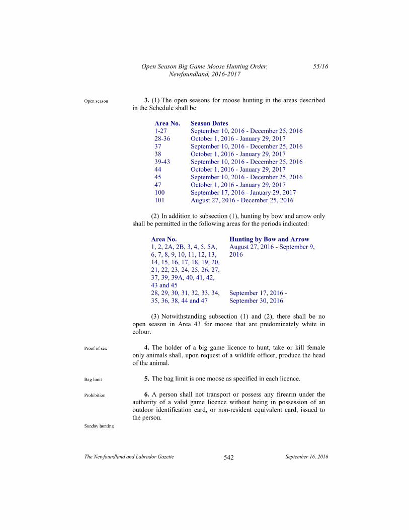
Open Season Big Game Moose Hunting Order, Newfoundland, 2016-2017
55/16
The Newfoundland and Labrador Gazette September 16, 2016
542
3. (1) The open seasons for moose hunting in the areas described in the Schedule shall be
Area No. Season Dates 1-27 September 10, 2016 - December 25, 2016 28-36 October 1, 2016 - January 29, 2017 37 September 10, 2016 - December 25, 2016 38 October 1, 2016 - January 29, 2017 39-43 September 10, 2016 - December 25, 2016 44 October 1, 2016 - January 29, 2017 45 September 10, 2016 - December 25, 2016 47 October 1, 2016 - January 29, 2017 100 September 17, 2016 - January 29, 2017 101 August 27, 2016 - December 25, 2016
(2) In addition to subsection (1), hunting by bow and arrow only shall be permitted in the following areas for the periods indicated:
Area No. Hunting by Bow and Arrow 1, 2, 2A, 2B, 3, 4, 5, 5A, 6, 7, 8, 9, 10, 11, 12, 13, 14, 15, 16, 17, 18, 19, 20, 21, 22, 23, 24, 25, 26, 27, 37, 39, 39A, 40, 41, 42, 43 and 45
August 27, 2016 - September 9, 2016
28, 29, 30, 31, 32, 33, 34, 35, 36, 38, 44 and 47
September 17, 2016 - September 30, 2016
(3) Notwithstanding subsection (1) and (2), there shall be no open season in Area 43 for moose that are predominately white in colour.
4. The holder of a big game licence to hunt, take or kill female only animals shall, upon request of a wildlife officer, produce the head of the animal.
5. The bag limit is one moose as specified in each licence.
6. A person shall not transport or possess any firearm under the authority of a valid game licence without being in possession of an outdoor identification card, or non-resident equivalent card, issued to the person.
Open season
Proof of sex
Bag limit
Prohibition
Sunday hunting
Open Season Big Game Moose Hunting Order, Newfoundland, 2016-2017
55/16
The Newfoundland and Labrador Gazette September 16, 2016
543
7. Hunting with a firearm on Sundays shall be permitted across the entire province, beginning October 2, 2016 and ending April 30, 2017, for the species and during the seasons as described in this Order.
8. The Open Season Big Game Moose Hunting Order, Newfoundland, 2015-2016, Newfoundland and Labrador Regulation 61/15, is repealed.
Repeal
Open Season Big Game Moose Hunting Order, Newfoundland, 2016-2017
55/16
The Newfoundland and Labrador Gazette September 16, 2016
544
Schedule
(a) Management Area 1 - St. Anthony
All that area of the Island of Newfoundland bounded by a line commencing at a bridge on the Viking Trail, Route 430 at Eddies Cove given by the coordinates 538,272 metres east and 5,695,888 metres north;
Then following the eastern bank of the river flowing under said bridge in a generally northerly direction to the coastline of the Great Northern Peninsula;
Then following the coastline of the Great Northern Peninsula along the Strait of Belle Isle in a generally northeasterly direction to Cape Norman;
Then following the coastlines of Cape Norman Bay, Pistolet Bay, Ha Ha Bay, Savage Cove, Sacred Bay and Hay Cove in generally southerly, then easterly, then northwesterly, then northeasterly, then easterly direction to Cobbler Point;
Then following the eastern coastline of the Great Northern Peninsula in a generally south westerly direction to Goose Cape;
Then following the northern coastline of Hare Bay in a generally westerly direction to Northeast Stream;
Then following the western bank of Northeast Stream in a generally northerly direction to its intersection with a point on the Viking Trail, Route 430 given by the coordinates 568,541 metres east and 5,691,775 metres north;
Then following the Viking Trail in a generally westerly direction to the point of commencement, excluding all offshore islands except Quirpon Island.
(b) Management Area 2 - Portland Creek
All that area of the Island of Newfoundland bounded by a line beginning at a point northeast of Shallow Bay on the
Open Season Big Game Moose Hunting Order, Newfoundland, 2016-2017
55/16
The Newfoundland and Labrador Gazette September 16, 2016
545
Gulf of St. Lawrence at UTM coordinates 445,004 metres east and 5,536,128 metres north;
Then following the coastline in a generally northeasterly direction to the mouth of Eddies Brook at Eddies Cove West;
Then following the north bank of said brook in a generally southeasterly direction to UTM coordinates 487,996 metres east and 5,622,053 metres north;
Then following a straight line in a southeasterly direction to the southern extremity of Rocky Stint Pond at the headwaters of Soufflets River at UTM coordinates 518,370 metres east and 5,596,857 metres north;
Then following a straight line in a southwesterly direction to the southeastern extremity of Middle Gulch at UTM coordinates 513,479 metres east and 5,594,856 metres north;
then following a straight line in a southwesterly direction to the western extremity of an unnamed lake at UTM coordinates 498,901 metres east and 5,586,818 metres north;
Then following a straight line in a southwesterly direction to UTM coordinates 493,900 metres east and 5,580,245 metres north;
Then following a straight line in a southwesterly direction to the outflow of a brook at an unnamed lake at UTM coordinates 484,823 metres east and 5,565,024 metres north;
then following a straight line in a southwesterly direction to the summit of Gros Pate at UTM coordinates 474,504 metres east and 5,562,405 metres north;
Then following a straight line in a southwesterly direction to an unnamed peak at UTM coordinates 471,484 metres east and 5,560,140 metres north;
Then following a straight line in a southeasterly direction to UTM coordinates 476,288 metres east and 5,550,252 metres north;
Open Season Big Game Moose Hunting Order, Newfoundland, 2016-2017
55/16
The Newfoundland and Labrador Gazette September 16, 2016
546
Then following a straight line in a southwesterly direction to the eastern bank of an unnamed brook at UTM coordinates 474,676 metres east and 5,548,673 metres north;
Then following a straight line in a southwesterly direction to the confluence of the unnamed brooks at UTM coordinates 464,734 metres east and 5,531,834 metres north;
Then following a straight line in a southwesterly direction to its intersection with the Gros Morne National Park boundary at UTM coordinates 461,821 metres east and 5,531,131 metres north;
Then following a straight line in a northwesterly direction along the Gros Morne National Park boundary to UTM coordinates 459,789 metres east and 5,532,233 metres north;
Then following a straight line in a northwesterly direction to the point of commencement;
Excluding all offshore islands.
(c) Management Area 2A- Cow Head- St. Paul's Enclaves
Area 2a St. Paul's Enclave Part 1
All that area of Newfoundland commencing at the shoreline of the Great Northern Peninsula, ordinary low water mark, and a point located at 5522671.22 metres north and 351144.9 metres east;
Then following an azimuth of 170° 42' 04" for a distance of 217 metres;
Then following an azimuth of 145° 18' 11" for a distance of 3005 metres;
Then following an azimuth of 92° 19' 54" for a distance of 2837.92 metres;
Then continuing on the aforementioned azimuth for an additional 25 metres to the ordinary low water mark of St. Paul's inlet;
Open Season Big Game Moose Hunting Order, Newfoundland, 2016-2017
55/16
The Newfoundland and Labrador Gazette September 16, 2016
547
Then following the southern shoreline of St. Paul's inlet in a generally north-westerly direction to St. Paul's bay;
Then following the southern shoreline of St. Paul's bay in a generally westerly direction to its confluence with the Gulf of St. Lawrence;
Then following the western shoreline of the Great Northern Peninsula in a southerly direction to the point of commencement.
Bearings, distance and coordinates have been recorded using 3º Modified Transverse Mercator Projection (Zone 3 Newfoundland).
Area 2a: Cow Head Enclave Part 2
All that area of Newfoundland commencing at the Ordinary Low Water Mark and a point located at 5525943.436 metres north and 358011.496 metres east;
Then following an azimuth of 50° 53' 41" for a distance of 5952.559 metres;
Then following an azimuth of 287° 28' 16" for a distance of 4694.308 metres;
Then following an azimuth of 302° 13' 27" for a distance of 1807.12 metres;
Then continuing on the aforementioned azimuth for an additional 160 metres to Cow Head Harbour;
Then following the western shoreline of the Great Northern Peninsula in a generally southerly direction to St. Paul's bay;
Then following the northern shoreline of St. Paul's bay and St. Paul's inlet to the point of commencement.
(d) Management Area 2B- Sally's Cove
Area 2b Sally's Cove
Open Season Big Game Moose Hunting Order, Newfoundland, 2016-2017
55/16
The Newfoundland and Labrador Gazette September 16, 2016
548
All that area of Newfoundland commencing at a point on the Great Northern Peninsula located at 5,508,816.74 metres north and 344,627.23 metres east;
Then following an azimuth of 117° 29' 40" for a distance of 2721.25 metres;
Then following an azimuth of 117° 18' 19" for a distance of 757.76 metres;
Then following an azimuth of 117° 14' 46" for a distance of 447.83 metres;
Then following an azimuth of 27° 27' 43" for a distance of 2308.21 metres;
Then following an azimuth of 27° 22' 28" for a distance of 1737.07 metres;
Then following an azimuth of 297° 29' 41" for a distance of 3639.94 metres;
Then continuing on the aforementioned azimuth for an additional 130 metres to the ordinary low water mark of Sally's Cove;
Then following the shoreline of Sally's Cove in a southerly direction to the point located 93 metres on an azimuth of 117° 29' 40" to the point of commencement.
Bearings, distance and coordinates have been recorded using 3º Modified Transverse Mercator Projection (Zone 3 Newfoundland).
(e) Management Area 3 - Harbour Deep
All that area of the Island of Newfoundland bounded by a line beginning at UTM coordinates 466,410 metres east and 5,513,474 metres north on the Gros Morne National Park boundary;
Open Season Big Game Moose Hunting Order, Newfoundland, 2016-2017
55/16
The Newfoundland and Labrador Gazette September 16, 2016
549
Then following the Gros Morne National Park boundary in a generally northwesterly direction to UTM coordinates 461,201 metres east and 5,520,574 metres north;
Then following the Gros Morne National Park boundary in a generally northerly direction to UTM coordinates 461,821 metres east and 5,531,131 metres north;
Then following a straight line in a northeasterly direction to the confluence of unnamed brooks at UTM coordinates 464,734 metres east and 5,531,834 metres north;
Then following a straight line in a northeasterly direction to the eastern bank of an unnamed brook at UTM coordinates 474,676 metres east and 5,548,673 metres north;
Then following a straight line in a northeasterly direction to UTM coordinates 476,288 metres east and 5,550,252 metres north;
Then following a straight line in a northwesterly direction to an unnamed peak at UTM coordinates 471,484 metres east and 5,560,140 metres north;
Then following a straight line in a northeasterly direction to the summit of Gros Pate at UTM coordinates 474,504 metres east and 5,562,405 metres north;
Then following a straight line in a northeasterly direction to the mouth of a brook on the unnamed lake at UTM coordinates 484,823 metres east and 5,565,024 metres north;
Then following a straight line in a northeasterly direction to UTM coordinates 493,900 metres east and 5,580,245 metres north;
Then following a straight line in a northeasterly direction to the western extremity of an unnamed lake at UTM coordinates 498,901 metres east and 5,586,818 metres north;
Then following a straight line in a northeasterly direction to the southeastern extremity of Middle Gulch at UTM coordinates 513,479 metres east and 5,594,856 metres north;
Open Season Big Game Moose Hunting Order, Newfoundland, 2016-2017
55/16
The Newfoundland and Labrador Gazette September 16, 2016
550
Then following a straight line in a northeasterly direction to the southern extremity of Rocky Stint Pond at the headwaters of Soufflets River at UTM coordinates 518,370 metres east and 5,596,857 metres north;
Then following a straight line in a generally easterly direction to the brook outflow into Northern Arm, at the head of Fourche Harbour;
Then following the eastern coastline of the Great Northern Peninsula in a generally southwesterly direction to a point on the northwestern bank of the outflow of Big Arm Brook into Great Coney Arm;
Then following a straight line in a generally southwesterly direction to the point of commencement;
Excluding all offshore islands.
(f) Management Area 4 – Taylors Brook
All the area of the Island of Newfoundland bounded by a line beginning at the intersection of the Viking Trail, Route 430, and the Gros Morne National Park boundary near Wiltondale at UTM coordinates 455,575 metres east and 5,472,309 metres north;
Then following the eastern side of the park boundary in a generally easterly, then northerly direction to UTM coordinates 466,410 metres east and 5,513,474 metres north;
Then following a straight line in a northeasterly direction to the northwestern bank of the mouth of Big Arm Brook, at Great Coney Arm;
Then following the eastern coastline of Great Coney Arm in a generally northeasterly direction to Coney Head;
Then following the coastline of White Bay in a generally southerly direction to the mouth of Hampden River into White Bay;
Open Season Big Game Moose Hunting Order, Newfoundland, 2016-2017
55/16
The Newfoundland and Labrador Gazette September 16, 2016
551
Then following the coastline of White Bay in a generally northeasterly direction to the mouth of Little Chouse Brook into White Bay;
Then following the southwestern bank of Little Chouse Brook in a southeasterly direction to its confluence with Little Chouse Brook Pond;
Then following the western shoreline of Little Chouse Brook Pond in a southeasterly direction to said pond's southern extremity;
Then following a straight line in a southerly direction to the northern extremity of an unnamed pond at UTM coordinates 520,543 metres east and 5,486,796 metres north;
Then following the western, southern, and southeastern shorelines of said pond to its eastern extremity at UTM coordinates 520,668 metres east and 5,486,656 metres north;
Then following a straight line in a southeasterly direction to the northern extremity of an unnamed pond located at UTM coordinates 520,682 metres east and 5,486,634 metres north;
Then following the southwestern shoreline of this pond and associated waterways in a generally southeasterly direction to Upper Indian Pond at UTM coordinates 524,009 metres east and 5,484,173 metres north;
Then following the western shoreline of Upper Indian Pond in a generally southeasterly direction to a stream in said pond's southwestern extremity;
Then following the eastern bank of said stream in a southwesterly direction to its confluence with Indian Brook at UTM coordinates 524,286 metres east and 5,472,137 metres north;
Then following the western bank of Indian Brook in a generally southeasterly direction to the diversion dam on said brook;
Open Season Big Game Moose Hunting Order, Newfoundland, 2016-2017
55/16
The Newfoundland and Labrador Gazette September 16, 2016
552
Then following along the western bank of the Indian Brook diversion waterway in a generally southeasterly direction to its intersection with the old Trans Canada Highway;
Then following the southern bank of said waterway in a generally southwesterly direction to its outflow into Birchy Lake;
Then following the southern shoreline of Birchy Lake and then the southern and eastern shorelines of Sandy Lake to UTM coordinates 489,016 metres east and 5,447,423 metres north near Howley;
Then following a straight line in a southwesterly direction to UTM coordinates 488,561 metres east and 5,446,710 metres north;
Then following the southern shoreline along "Sandy Dump" in a southwesterly direction to UTM coordinates 488,517 metres east and 5,446,655 metres north;
Then following a straight line in a southwesterly direction to UTM coordinates 487,298 metres east and 5,446,324 metres north;
Then following the northern shoreline of Grand Lake in a generally westerly direction to Glide Brook Steady;
Then following the northern shoreline of Glide Brook Steady in a generally westerly direction to Humber Canal;
Then following the northern shoreline of the Humber Canal in a generally southwesterly direction to the penstocks at the Deer Lake Power Generating Station;
Then following the westernmost penstock in a northwesterly direction to the Deer Lake Power Generating Station;
Then following the western shoreline of the Deer Lake Power Generating Station outflow in a northerly direction to the TCH;

Open Season Big Game Moose Hunting Order, Newfoundland, 2016-2017
55/16
The Newfoundland and Labrador Gazette September 16, 2016
553
Then following the TCH in a northeasterly direction to its intersection with Route 430;
Then following Route 430 in a northwesterly direction to the point of commencement;
Excluding all offshore islands.
(g) Management Area 5 - Trout River
All that area of the Island of Newfoundland bounded by a line beginning at the Gros Morne National Park boundary on the Gulf of St. Lawrence at UTM coordinates 418,782 metres east and 5,483,150 metres north;
Then following this boundary line in a generally southerly, then easterly direction to its intersection with the Viking Trail, Route 430, near Wiltondale at UTM coordinates 455,575 metres east and 5,472,309 metres north;
Then following Route 430 in a generally southeasterly direction to its intersection with the Trans Canada Highway, TCH, Route 1, in the Town of Deer Lake;
Then following the TCH in a southwesterly direction to the western abutment of a bridge at Humber Canal Spillway Crossing;
Then following the southeastern shoreline of Deer Lake and the Humber River in a generally southwesterly direction to the southern abutment of Ballam Bridge, near the mouth of the Humber River;
Then crossing Ballam Bridge to its northern abutment and then following the northern bank of the Humber River in a generally northwesterly direction to its outflow into the Humber Arm, Bay of Islands;
Then following the northern coastline of the Humber Arm and the Bay of Islands in a generally northwesterly direction to Crabb Point;

Open Season Big Game Moose Hunting Order, Newfoundland, 2016-2017
55/16
The Newfoundland and Labrador Gazette September 16, 2016
554
Then following the coastline of insular Newfoundland in a generally northerly direction to the point of commencement;
Excluding all offshore islands.
(h) Management Area 5A- Rocky Harbour Eastern and Western Enclaves
Area 5a Rocky Harbour Eastern (Interior) Enclave
All that area of Newfoundland commencing on the Great Northern Peninsula located at 5,496,416.35 metres north and 345,632.49 metres east;
Then following an azimuth of 45º 06' 13" for a distance of 1919.18 metres;
Then following an azimuth of 116º 05' 43" for a distance of 1385.20 metres;
Then following an azimuth of 54º 24' 33" for a distance of 275.48 metres;
Then following an azimuth of 97º 58' 36" for a distance of 24.19 metres;
Then following an azimuth of 42º 58' 51" for a distance of 46.68 metres;
Then following an azimuth of 70º 07' 33" for a distance of 35.41 metres;
Then following an azimuth of 18º 53' 58" for a distance of 33.74 metres;
Then following an azimuth of 20º 26' 13" for a distance of 99.43 metres;
Then following an azimuth of 347º 06' 02" for a distance of 2599.63 metres;
Then following an azimuth of 84º 19' 06" for a distance of 2352.11 metres;
Open Season Big Game Moose Hunting Order, Newfoundland, 2016-2017
55/16
The Newfoundland and Labrador Gazette September 16, 2016
555
Then following an azimuth of 194º 30' 18" for a distance of 1516.92 metres to an unnamed stream;
Then following the southern bank of this unnamed stream in a generally easterly direction to Halfmoon Pond;
Then following the southern shoreline of Halfmoon Pond to an unnamed stream emptying said pond;
Then following this unnamed stream in a south easterly direction to Eastern Arm Pond also known as Deer Pond;
Then following the western shoreline of Eastern Arm Pond in a generally southerly direction to Deer Brook;
Then following the western bank of Deer Brook in a generally southerly direction to a bridge crossing Deer Brook at route 430;
Then following a line with an azimuth of 308º 06' 47" with a chord of 220.57 metres, an arc of 222.13 metres and with a radius of 539.43;
Then following an azimuth of 319º 54' 50" for a distance of 442.93;
Then following a line with an azimuth of 300º 07' 58" with a chord of 418.89 metres, an arc of 427.33 metres and with a radius of 618.96;
Then following an azimuth of 280º 21' 10" for 92.92 metres;
Then following a line with an azimuth of 272º 48' 07" with a chord of 164.69 metres, an arc of 165.17 metres and with a radius of 626.64;
Then following an azimuth of 265º 15' 17" for 493.65 metres;
Then following a line with an azimuth of 268º 51' 58" with a chord of 123.54 metres, an arc of 123.62 metres and with a radius of 980.58;
Open Season Big Game Moose Hunting Order, Newfoundland, 2016-2017
55/16
The Newfoundland and Labrador Gazette September 16, 2016
556
Then following an azimuth of 272º 28' 24" for a distance of 1794.74 metres;
Then following a line with an azimuth of 297º 48' 58" with a chord of 325.53 metres, an arc of 336.39 metres and with a radius of 380.28;
Then following an azimuth of 323º 09' 20" for a distance of 1302.31 metres;
Then following an azimuth of 323º 05' 10" for a distance of 2224.54 metres;
Then following an azimuth of 53º 01' 14" for a distance of 299.24 metres;
Then following an azimuth of 316º01'19" for a distance of 559.97 metres;
Then following an azimuth of 233º00'51" for a distance of 316.05 metres;
Then following a line with an azimuth of 287º 19' 41" with a chord of 15.33 metres, an arc of 15.33 metres and with a radius of 477.98;
Then following an azimuth of 286º 24' 06" for a distance of 650.83 metres to the point of commencement.
Area 5a Rocky Harbour Western (Coastal) Enclave
All that area of Newfoundland commencing on the shoreline of the Great Northern Peninsula, ordinary low water mark, and a point located at 5,487,529.294 metres north and 351,393.795 metres east;
Then following an azimuth of 07º 29' 34" for a distance of 1138.869 metres;
Then following an azimuth of 07º 29' 10" for a distance of 914.29 metres;
Open Season Big Game Moose Hunting Order, Newfoundland, 2016-2017
55/16
The Newfoundland and Labrador Gazette September 16, 2016
557
Then following an azimuth of 350º 23' 58" for a distance of 1816.514 metres;
Then following an azimuth of 348º 56' 58" for a distance of 238.544 metres;
Then following an azimuth of 275º 08' 26" for a distance of 1692.483 metres to a point on the southern extremity of Rocky Harbour pond;
Then following the eastern shoreline of Rocky Harbour Pond to a point located at 492,763.486 metres north and 348,863.717 metres east;
Then following an azimuth of 323º 07' 25" for a distance of 748.810 metres;
Then following an azimuth of 323º 07' 12" for a distance of 415.915 metres;
Then following an azimuth of 323º 07' 58" for a distance of 201.769 metres;
Then following an azimuth of 323º 07' 26" for a distance of 2814.964 metres;
Then following an azimuth of 286º 22' 16" for a distance of 778.944 metres;
Then following an azimuth of 196º 25' 42" for a distance of 645.735 metres;
Then continuing on the aforementioned azimuth to the ordinary low water mark of Rocky Harbour;
Then following the shoreline in a generally southerly direction to the point of commencement.
(i) Management Area 6 - Corner Brook
All that area of the Island of Newfoundland bounded by a line beginning at the southern abutment of Ballam Bridge on the Humber River, near Corner Brook;
Open Season Big Game Moose Hunting Order, Newfoundland, 2016-2017
55/16
The Newfoundland and Labrador Gazette September 16, 2016
558
Then following a straight line in a southwesterly direction to the Trans Canada Highway, TCH, Route 1 at UTM coordinates 434,793 metres east and 5,422,505 metres north;
Then following the TCH in a generally southwesterly direction to the northern abutment of the bridge crossing Southwest Brook;
Then following the north bank of Southwest Brook in a westerly direction to St. George's River;
Then following the north bank of St. George's River in a generally westerly then southerly direction to the northern extremity of Main Gut;
Then following the northern shoreline of St. George's Bay, and the western coastline of insular Newfoundland in a generally northeasterly direction to South Head, Bay of Islands;
Then following the southern shoreline of the Bay of Islands in a generally southeasterly direction to the point of commencement, excluding the Port au Port Peninsula and all offshore islands except Woods Island.
(j) Management Area 7 - South Brook
All that area of the Island of Newfoundland bounded by a line beginning at the Deer Lake Power Generating Station;
Then following the western most penstock in a southeasterly direction to the Humber Canal;
Then following the northern shoreline of the Humber Canal in a generally northeasterly direction to Glide Brook Steady;
Then following the northern shoreline of Glide Brook Steady in a generally easterly direction to Grand Lake;
Then following the northern shoreline of Grand Lake in a generally easterly direction to UTM coordinates 487,298 metres east and 5,446,324 metres north;
Open Season Big Game Moose Hunting Order, Newfoundland, 2016-2017
55/16
The Newfoundland and Labrador Gazette September 16, 2016
559
Then following a straight line in a northeasterly direction to UTM coordinates 488,517 metres east and 5,446,655 metres north;
Then following the western shoreline of this island in a generally southeasterly direction to a point at Howley Narrows at UTM coordinates 489,593 metres east and 5,444,444 metres north;
Then following a straight line due south to UTM coordinates 489,593 metres east and 5,444,293 metres north;
Then following the southeastern shoreline of Grand Lake in a southwesterly direction to the closest point opposite Camp 33 Road, near the southwestern extremity of Grand Lake;
Then following a straight line in a westerly direction to Camp 33 Road;
Then following a straight line to Camp 33 Road;
Then following Camp 33 Road in a northwesterly direction to its intersection with the Trans Canada Highway, TCH, Route 1;
Then following the TCH in a northeasterly direction to a point near Corner Brook at UTM coordinates 434,793 metres east and 5,422,505 metres north;
Then following a straight line in a northeasterly direction to a point near Corner Brook at UTM coordinates 434,793 metres east and 5,422,505 metres north;
Then following a straight line in a northeasterly direction to the southern abutment of Ballam Bridge on the southern bank of the Humber River;
Then following the southern bank of the Humber River and the southeastern shoreline of Deer Lake in a generally northeasterly direction to the point of commencement;
Including Glover Island.
Open Season Big Game Moose Hunting Order, Newfoundland, 2016-2017
55/16
The Newfoundland and Labrador Gazette September 16, 2016
560
(k) Management Area 8 - St. Georges
All that area of the Island of Newfoundland bounded by a line beginning at the northern bank of Crabbes River, directly due north of the northern extremity of Crabbes Head, at its outflow into the Gulf of St. Lawrence;
Then following the coastline of St. George's Bay in a generally northeasterly direction to the mouth of the St. George's River known as the Main Gut;
Then following the southern bank of St. George's River in a northeasterly direction to the southern abutment of a bridge crossing Southwest Brook at the Trans Canada Highway, TCH;
Then following said bridge and the TCH in generally northerly then northeasterly direction to Camp 33 Road;
Then following Camp 33 Road in a generally southeasterly direction to the southwestern extremity of Grand Lake;
Then following the southern shoreline of Grand Lake in a generally southeasterly direction to the outlet of Leewaseechjeech Brook at UTM coordinates 430,243 metres east and 5,386,794 metres north;
Then following the eastern bank of Leewaseechjeech Brook in a generally southerly then easterly direction to a bridge at its source on Little Grand Lake;
Then following a straight line in a generally southerly direction to the western extremity of North Lake;
Then following a straight line in a southwesterly direction to the western extremity of Dennis Pond;
Then following a straight line in a southwesterly direction to the northern extremity of John Marys Pond;
Then following a straight line in a southwesterly direction to the western extremity of Butt's Pond;
Open Season Big Game Moose Hunting Order, Newfoundland, 2016-2017
55/16
The Newfoundland and Labrador Gazette September 16, 2016
561
Then following a straight line in a southwesterly direction to the northwestern extremity of Hungry Grove Pond;
Then following the western shoreline of Hungry Grove Pond in a generally southerly direction to a small brook at its southern extremity;
Then following said brook in a generally southeasterly direction to its confluence with Crabbes River;
Then following the southern bank of Crabbes River in a generally northwesterly direction to the point of commencement;
Excluding all offshore islands.
(l) Management Area 9 - Auguille Mountains
All that area of the Island of Newfoundland bounded by a line beginning at Crabbes Head on the southern bank adjacent to the outflow of Crabbes River into the Gulf of St. Lawrence;
Then following the southern bank of Crabbes River in a generally southeasterly direction to its intersection with the southern abutment of a bridge connected to the Trans Canada Highway, TCH, Route 1;
Then following the TCH in a generally southwesterly direction to the northern abutment of a bridge crossing South Branch River;
Then following the northern bank of the South Branch River in a generally southwesterly direction to its confluence with the North Branch River;
Then following the north bank of the Grand Codroy River in a generally southwesterly direction to its outflow into the Gulf of St. Lawrence;
Then following the coastline in a generally northwesterly direction to Cape Anguille;
Open Season Big Game Moose Hunting Order, Newfoundland, 2016-2017
55/16
The Newfoundland and Labrador Gazette September 16, 2016
562
Then following the coastline in a generally northeasterly direction to the point of commencement;
Excluding all offshore islands.
(m) Management Area 10 - Port aux Basques
All that area of the Island of Newfoundland bounded by a line beginning at the outflow of Grand Codroy River at its northern extremity known as the Gut;
Then following the northern and western banks of the Grand Codroy River in a generally northeasterly direction to its confluence with the South Branch River;
Then following the north bank of the South Branch River in a generally northeasterly direction to the northern abutment of a bridge crossing said river at the Trans Canada Highway, TCH;
Then following the TCH, Route 1, in a generally northeasterly direction to the northern abutment of a bridge crossing the Crabbes River;
Then following the northern bank of Crabbes River in a generally southeasterly direction to its confluence with a stream originating from Hungry Grove Pond at UTM coordinates 386,822 metres east and 5,323,640 metres north;
Then following a straight line in a southeasterly direction to the head of North Bay, La Poile Bay at UTM coordinates 401,420 metres east and 5,296454 metres north;
Then following the coastline in a generally southerly then westerly direction to Cape Ray;
Then following the coastline in a generally northerly direction to the point of commencement;
Excluding all offshore islands.
Open Season Big Game Moose Hunting Order, Newfoundland, 2016-2017
55/16
The Newfoundland and Labrador Gazette September 16, 2016
563
(n) Management Area 11 – Dashwoods
All that area of the Island of Newfoundland bounded by a line beginning at the northern extremity of North Bay, La Poile Bay;
Then following a straight line in a northwesterly direction to the confluence of Crabbes River with a stream originating from Hungry Grove Pond at UTM coordinates 386,822 metres east and 5,323,640 metres north;
Then following the western bank of said stream and the western shoreline of Hungry Grove Pond in a generally northerly direction to its northwestern extremity;
Then following a straight line in a northeasterly direction to the western extremity of Butt's Pond;
Then following a straight line in a northeasterly direction to the northwestern extremity of John Marys Pond;
Then following a straight line in a northeasterly direction to the western extremity of Dennis Pond;
Then following a straight line in a northeasterly direction to the western extremity of North Lake;
Then following a straight line in a generally northerly direction to the northern abutment of a bridge at the outflow of Little Grand Lake into Leewaseechjeech Brook;
Then following the northern shoreline of Little Grand Lake and the northern banks of the eastern tributaries of Lewaseechjeech Brook in a generally southeasterly direction to an unnamed pond at UTM coordinates 464,325 metres east and 5,379,136 metres north;
Then following the northeastern shoreline of said pond in a generally easterly direction to a brook on its southeastern shoreline at UTM coordinates 466,651 metres east and 5,379,278 metres north;
Open Season Big Game Moose Hunting Order, Newfoundland, 2016-2017
55/16
The Newfoundland and Labrador Gazette September 16, 2016
564
Then following a straight line in a generally southerly direction to the southern shoreline of Lloyds Lake to its outflow at UTM coordinates 466,110 metres east and 5,363,092 metres north;
Then following the southern shoreline of Lloyds Lake and the southern bank of Lloyds River in a generally southwesterly direction to King George IV Lake;
Then following the eastern shoreline of King George IV Lake to its southernmost extremity at UTM coordinates 433,687 metres east and 5,335,140 metres north;
Then following a straight line in a southwesterly direction to the point of commencement.
(o) Management Area 12 – Buchans
All that area of the Island of Newfoundland bounded by a line beginning at the outflow of Leewaseechjeech Brook into Grand Lake at UTM coordinates 430,243 metres east and 5,386,794 metres north;
Then following the southeastern shoreline of Grand Lake in a generally northeasterly direction to Hinds Brook;
Then following the eastern bank of Hinds Brook in a southeasterly direction to Hinds Lake;
Then following the northeastern shoreline of Hinds Lake in a southeasterly direction to the mouth of a brook at the southeastern extremity of said lake at UTM coordinates 505,841 metres east and 5,416,632 metres north;
Then following a straight line in a southeasterly direction to the northwestern extremity of Buchans Lake;
Then following the western shoreline of Buchans Lake in a generally southeasterly direction to Buchans Brook;
Then following the southwestern bank of Buchans Brook in a southeasterly direction to its outflow into Red Indian Lake;
Open Season Big Game Moose Hunting Order, Newfoundland, 2016-2017
55/16
The Newfoundland and Labrador Gazette September 16, 2016
565
Then following the northern shoreline of Red Indian Lake in a generally northeasterly direction to the northern bank of Mary March's Brook at the Buchan's Junction Bridge;
Then following the southern bank of said brook and the northeastern shoreline of Red Indian Lake in a southwesterly direction to the Exploits Dam on said lake;
Then following the southern shoreline of Red Indian Lake in a generally southwesterly direction to its confluence with Lloyds River;
Then following the southeastern bank of Lloyds River in a generally southwesterly direction to its confluence with Lloyds Lake at UTM coordinates 466,110 metres east and 5,363,092 metres north;
Then following a straight line in a northerly direction to the mouth of a brook on an unnamed pond at UTM coordinates 466,651 metres east and 5,379,278 metres north;
Then following the southeastern and then northern shoreline of this unnamed pond in a generally westerly direction to its outflow at UTM coordinates 464,325 metres east and 5,379,136 metres north into the eastern tributary of Leewaseechjeech Brook;
Then following the northern bank of the eastern tributary of Leewaseechjeech Brook in a generally westerly direction to its confluence with the main branch of Leewaseechjeech Brook;
Then following main branch Leewaseechjeech Brook in a generally westerly direction to its outflow into Little Grand Lake;
Then following the northern shoreline of Little Grand Lake in a northwesterly direction to a northern abutment of a bridge at said lake's northwestern extremity;
Then following the eastern bank of Leewaseechjeech Brook in a generally westerly then northerly direction to the point of commencement.

Open Season Big Game Moose Hunting Order, Newfoundland, 2016-2017
55/16
The Newfoundland and Labrador Gazette September 16, 2016
566
(p) Management Area 13 - Gaff Topsails
All that area of the Island of Newfoundland bounded by a line beginning at the outflow of Hinds Brook into Grand Lake;
Then following the northeastern shoreline of Grand Lake in a northeasterly direction to Howley Narrows at UTM coordinates 489,593 metres east and 5,444,293 metres north;
Then following a straight line due north to an unnamed island at UTM coordinates 489,593 metres east and 5,444,444 metres north;
Then following the western shoreline of this island in a generally northwesterly direction to a point located at UTM coordinates 488,561 metres east and 5,446,710 metres north;
Then following a straight line in a northeasterly direction to UTM coordinates 489,016 metres east and 5,447,423 metres north;
Then following the southeastern shoreline of Sandy Lake in a northeasterly direction to its confluence with Kitty's Brook;
Then following the southwestern bank of Kitty's Brook in a southeasterly direction to its intersection with the T'Railway bridge, also known as "Kitty's Brook Main Trussel Bridge" at UTM coordinates 510,346 metres east and 5,446,025 metres north;
Then following the T'Railway in a generally southeasterly direction to the bridge crossing Barneys Brook at UTM coordinates 528,340 metres east and 5,440,372 metres north;
Then following a straight line in a generally easterly direction to a brook at the northwestern extremity of Little Sandy Pond at UTM coordinates 545,464 metres east and 5,442,569 metres north;

Open Season Big Game Moose Hunting Order, Newfoundland, 2016-2017
55/16
The Newfoundland and Labrador Gazette September 16, 2016
567
Then following the northern and eastern shorelines of Little Sandy Pond in a generally southerly direction to a small stream in the southern extremity of said pond;
Then following the eastern bank of said stream in a southeasterly direction to its confluence with South Brook at UTM coordinates 547,978 metres east and 5,435,038 metres north;
Then following the northwestern bank of South Brook in a northeasterly direction to its confluence with Gull Brook at UTM coordinates 563,467 metres east and 5,458,438 metres north;
Then following a straight line in a generally easterly direction to the closest point on the Trans Canada Highway, TCH, Route 1, at UTM coordinates 564,419 metres east and 5,458,458 metres north;
Then following the TCH in a southeasterly direction to the westernmost abutment of the TCH bridge crossing Badger Brook in the town of Badger;
Then following the western bank of said brook in a generally southerly direction to its confluence with the Exploits River at UTM coordinates 570,788 metres east and 5,425,111 metres north;
Then following a straight line due south to the southern bank of the Exploits River;
Then following the southern bank of the Exploits River in a southwesterly direction to the Exploits Dam on Red Indian Lake;
Then following the eastern shoreline of Red Indian Lake in a generally northeasterly direction to the southern bank of Mary March's Brook at the Buchan's Junction bridge at UTM coordinates 538,174 metres east and 5,410,758 metres north;
Open Season Big Game Moose Hunting Order, Newfoundland, 2016-2017
55/16
The Newfoundland and Labrador Gazette September 16, 2016
568
Then following the northern shoreline of Red Indian Lake in a generally southwesterly direction to its confluence with Buchans Brook;
Then following the southwestern bank of Buchans Brook in a northwesterly direction to its confluence with Buchans Lake;
Then following the western shoreline of Buchans Lake in a northwesterly direction to its northern extremity;
Then following a straight line in a northwesterly direction to the southeastern extremity of Hinds Lake at UTM coordinates 505,841 metres east and 5,416,632 metres north;
Then following the northeastern shoreline of Hinds Lake in a northwesterly direction to Hinds Brook;
Then following the northeastern bank of Hinds Brook in a generally northwesterly direction to the point of commencement.
(q) Management Area 14 - Baie Verte
All that area of the Island of Newfoundland bounded by line beginning at the outflow of South Brook into Halls Bay;
Then following the western bank of this brook in a generally southerly direction to its intersection with the western abutment of a bridge on the Trans Canada Highway, TCH, Route 1;
Then following the TCH in a generally westerly direction to its intersection with the old Trans Canada Highway route at UTM coordinates 528,093 metres east and 5,468,306 metres north;
Then following the old TCH in a generally northwesterly direction to its intersection with the western bank of the Indian Brook Diversion waterway;

Open Season Big Game Moose Hunting Order, Newfoundland, 2016-2017
55/16
The Newfoundland and Labrador Gazette September 16, 2016
569
Then following the western bank of said waterway in a generally north by northwesterly direction to its confluence with the original southwestern bank of Indian Brook;
Then following the southwestern bank of Indian Brook in a northwesterly direction to its confluence with a brook flowing from Upper Indian Pond at UTM coordinates 524,286 metres east and 5,472,137 metres north;
Then following the northwestern bank of this unnamed stream in a northeasterly direction to its confluence with Upper Indian Pond;
Then following the western shoreline of Upper Indian Pond in a northwesterly direction to its confluence with a brook at UTM coordinates 524,009 metres east and 5,484,173 metres north;
Then following the southwestern bank of said brook and associated waterways in a northwesterly direction to the northern extremity of an unnamed pond at UTM coordinates 520,682 metres east and 5,486,634 metres north;
Then following a straight line in a northwesterly direction to the eastern extremity of an unnamed pond at UTM coordinates 520,668 metres east and 5,486,656 metres north;
Then following the southeastern, southern, and western shorelines of said pond in a generally northerly direction to its northern extremity at UTM coordinates 520,543 metres east and 5,486,796 metres north;
Then following a straight line in a northerly direction to the southern extremity of Little Chouse Brook Pond;
Then following the western shoreline of said pond in a northwesterly direction to its confluence with Little Chouse Brook;
Then following the southwestern bank of Little Chouse Brook in a northwesterly direction to its confluence with White Bay;
Open Season Big Game Moose Hunting Order, Newfoundland, 2016-2017
55/16
The Newfoundland and Labrador Gazette September 16, 2016
570
Then following the coastline of White Bay in a northeasterly direction to Partridge Point;
Then following the coastline of insular Newfoundland in a generally southeasterly direction to Ragged Point;
Then following the coastline of Notre Dame Bay in a southwesterly direction to Halls Bay;
Then following the coastline of Halls Bay in a generally southwesterly direction to the point of commencement;
Excluding all offshore islands.
(r) Management Area 15 - Twin Lakes
All that area of the island of Newfoundland bounded by a line beginning at the mouth of South Brook in Halls Bay;
Then following the coastline of Notre Dame Bay in a generally easterly direction to the Bay of Exploits;
Then following the shoreline of the Bay of Exploits in a generally southwesterly direction to its confluence with the Exploits River;
Then following the southern bank of the Exploits River in a generally southwesterly direction to a point near Badger at UTM coordinates 570,788 metres east and 5,424,841 metres north;
Then following a straight line due north to the confluence of the Exploits River with Badger Brook at UTM coordinates 570,788 metres east and 5,425,111 metres north;
Then following the western bank of Badger Brook in a generally northerly direction to the westernmost abutment of the Trans Canada Highway, TCH, Route 1 bridge crossing Badger Brook;
Then following the TCH in a generally northwesterly, then northerly direction to the western abutment of the bridge crossing South Brook at Halls Bay;
Open Season Big Game Moose Hunting Order, Newfoundland, 2016-2017
55/16
The Newfoundland and Labrador Gazette September 16, 2016
571
Then following the western bank of South Brook in a northwesterly direction to the point of commencement;
Excluding all offshore islands except Pilley's Island, Triton Island, Long Island, and Sunday Cove Island.
(s) Management Area 16 - Sandy Badger
All that area of the Island of Newfoundland bounded by a line beginning at the confluence of the western bank of Noel Paul's Brook with the Exploits River;
then following the southern bank of the Exploits River in a northeasterly, then easterly direction to its confluence with Great Rattling Brook;
Then following the western bank of Great Rattling Brook in a southeasterly direction to UTM coordinates 608,314 metres east and 5,420,444 metres north;
Then following a straight line in a southwesterly direction to the eastern extremity of Island Pond;
Then following a straight line in a southwesterly direction to the eastern extremity of Pistol Lake;
Then following a straight line in a southeasterly direction to the northwestern extremity of an unnamed pond on the headwaters of South Great Rattling Brook at UTM coordinates 585,800 metres east and 5,370,902 metres north;
Then following a straight line in a westerly direction to the northern extremity of Gulp Pond;
Then following a straight line in a generally westerly direction to the northern extremity of Island Pond at UTM coordinates 547,981 metres east and 5,367,922 metres north;
Then following a straight line in a northeasterly direction to the outlet of Noel Paul's Steady at UTM coordinates 556,596 metres east and 5,390,449 metres north;
Open Season Big Game Moose Hunting Order, Newfoundland, 2016-2017
55/16
The Newfoundland and Labrador Gazette September 16, 2016
572
Then following the western bank of said brook in a northwesterly direction to the point of commencement.
(y) Management Area 17 – Millertown
All that area of the Island of Newfoundland bounded by a line beginning at the northeastern extremity of Lloyds Lake at UTM coordinates 466,110 metres east and 5,363,092 metres north;
Then following the southeastern bank of Lloyds River in a northeasterly direction to its confluence with Red Indian Lake;
Then following the southeastern shoreline of Red Indian Lake in a northeasterly direction to the Exploits Dam;
Then following the southern bank of the Exploits River in a northeasterly direction to its confluence with Noel Paul's Brook;
Then following the western bank of said brook in a southeasterly direction to Noel Paul's Steady at UTM coordinates 556,596 metres east and 5,390,449 metres north;
Then following a straight line in a southwesterly direction to the northern extremity of Island Pond at UTM coordinates 547,981 metres east and 5,367,922 metres north;
Then following the eastern shoreline of Island Pond in a generally southwesterly direction to a brook at its southern extremity at UTM coordinates 545,742 metres east and 5,351,847 metres north;
Then following a straight line in a generally southwesterly direction to the southern extremity of Blizzard Pond at UTM coordinates 509,389 metres east and 5,351,847 metres north;
Then following a straight line in a northwesterly direction to the point of commencement.
Open Season Big Game Moose Hunting Order, Newfoundland, 2016-2017
55/16
The Newfoundland and Labrador Gazette September 16, 2016
573
(u) Management Area 18 - Granite Lake
All that area of the Island of Newfoundland bounded by a line beginning at the northeastern extremity of Lloyds Lake at UTM coordinates 466,110 metres east and 5,363,092 metres north;
Then following a straight line in a generally southeasterly direction to the southern extremity of Blizzard Pond at UTM coordinates 509,389 metres east and 5,351,847 metres north;
Then following a straight line in a generally northeasterly direction to the southern extremity of Island Pond at UTM coordinates 545,742 metres east and 5,360,251 metres north;
Then following a straight line in a southeasterly direction to the southwestern extremity of Cold Spring Pond;
Then following a straight line in a generally southwesterly direction to the southern extremity of Wolf Lake;
Then following a straight line in a southwesterly direction to a brook at the northwestern extremity of Top Pond;
Then following a straight line in a northwesterly direction to the southern extremity of Buck Lake;
Then following a straight line due west to the Burgeo Highway, Route 480, at UTM coordinates 450,628 metres east and 5,317,455 metres north;
Then following the Burgeo Highway in a generally northerly direction to the southernmost abutment of a bridge crossing Lloyds River;
Then following the southeastern bank of Lloyds River in a northeasterly direction to its confluence with Lloyds Lake;
Then following the southern shoreline of Lloyds Lake in a generally northeasterly direction to the point of commencement.
Open Season Big Game Moose Hunting Order, Newfoundland, 2016-2017
55/16
The Newfoundland and Labrador Gazette September 16, 2016
574
(v) Management Area 19 - Grey River West
All that area of the Island of Newfoundland bounded by a line beginning at the northern extremity of North Bay, La Poile Bay;
Then following a straight line in a northeasterly direction to the southernmost extremity of King George IV Lake at UTM coordinates 433,687 metres east and 5,335,140 metres north;
Then following the eastern shoreline of King George IV Lake in a generally northerly direction to its confluence with the southeastern bank of Lloyds River;
Then following the southeastern bank of Lloyds River in a northeasterly direction to the southern abutment of a bridge intersecting the Burgeo Highway, Route 480;
Then following the Burgeo Highway in a generally southerly direction to UTM coordinates 450,628 metres east and 5,317,455 metres north;
Then following a straight line due east to the southwestern extremity of Buck Lake;
Then following a straight line in a southeasterly direction to a brook at the northwestern extremity of Top Pond;
Then following a straight line in a generally northeasterly direction to the western bank of White Bear River at UTM coordinates 477,316 metres east and 5,314,742 metres north;
Then following the western bank of White Bear River in a southerly direction to its confluence with White Bear Bay;
Then following the western shoreline of White Bear Bay in a southwesterly direction to Northwest Head;
Then following the coastline in a generally westerly direction to the point of commencement;
Excluding all offshore islands.
Open Season Big Game Moose Hunting Order, Newfoundland, 2016-2017
55/16
The Newfoundland and Labrador Gazette September 16, 2016
575
(w) Management Area 20 - Round Pond
All that area of the Island of Newfoundland bounded by a line beginning at the confluence of the western bank of d'Espoir Brook with North Bay, Bay d'Espoir;
Then following a straight line northwest to the southwestern extremity of Cold Spring Pond;
Then following a straight line in a northwesterly direction to the southeastern extremity of Island Pond at UTM coordinates 545,742 metres east and 5,360,251 metres north;
Then following the eastern shoreline of Island Pond to its northern extremity at UTM coordinates 547,981 metres east and 5,367,922 metres north;
Then following a straight line in a generally easterly by northeasterly direction to the northern extremity of Gulp Pond;
Then following a straight line in an easterly direction to the northwestern extremity of a pond on the headwaters of South Great Rattling Brook at UTM coordinates 585,800 metres east and 5,370,902 metres north;
Then following a straight line in an easterly by southeasterly direction to the Northwest Gander River at UTM coordinates 601,894 metres east and 5,368,055 metres north;
Then following the southeastern bank of the Northwest Gander River in a southwesterly, then southerly direction to its confluence with Stormy Brook;
Then following the northern and eastern banks and shorelines of Stormy Brook river system to the southernmost extremity of a pond at its headwaters;
Then following a straight line in a southerly direction to the southwestern extremity of Matthew's Pond;
Open Season Big Game Moose Hunting Order, Newfoundland, 2016-2017
55/16
The Newfoundland and Labrador Gazette September 16, 2016
576
Then following a straight line in a generally southwesterly direction to the southeastern arm of Jeddore Lake at the western abutment of the Dam;
Then following the eastern shoreline of said lake in a generally southwesterly direction to the outflow of Salmon River at its southernmost extremity;
Then following the northwestern bank of Salmon River in a generally southerly direction to its confluence with East Bay, Bay d'Espoir;
Then following the western coastline of East Bay in a southwesterly direction to Stone Point;
Then following the eastern coastline of North Bay, Bay d'Espoir in a northwesterly direction to the point of commencement;
Excluding all offshore islands.
(x)Management Area 21 - Rattling Brook
All that area of the Island of Newfoundland bounded by a line beginning at the western abutment of the bridge crossing Rattling Brook along the Trans Canada Highway, TCH, Route 1;
Then following the western bank of Rattling Brook in a southerly direction to its confluence with Rattling Lake;
Then following the western and then southern shoreline of Rattling Lake in a southeasterly direction to the stream at its southeastern extremity;
Then following the southwestern bank of this stream to the southwestern shoreline of an unnamed pond and continuing on in a southeasterly direction to a stream flowing from Upper Christmas Pond;
Then following the western then southern shoreline of Upper Christmas Pond in a southeasterly direction to the main channel of the stream flowing from an unnamed pond;
Open Season Big Game Moose Hunting Order, Newfoundland, 2016-2017
55/16
The Newfoundland and Labrador Gazette September 16, 2016
577
Then following the western shoreline of said unnamed pond in a generally southerly direction to a brook at its southern extremity;
Then following the southwestern bank of said brook in a southeasterly direction to its confluence with Lewis Pond;
Then following the southwestern shoreline of Lewis Pond in a southeasterly direction to a stream flowing from Little Dowd Pond;
Then following the southern bank of this stream in a southeasterly direction to Little Dowd Pond;
Then following the western, then southern shorelines of Little Dowd Pond in a southerly direction to a stream at said pond's southern extremity;
Then following the western bank of said stream in a southeasterly direction to Dowd Pond;
Then following the western, then southern shorelines of Dowd Pond to a brook at said pond's southeastern extremity;
Then following a straight line in a southwesterly direction to the eastern bank of the mouth of Great Gull River on the Northwest Gander River;
Then following the southern bank of the Northwest Gander River in a generally westerly then southwesterly direction to UTM coordinates 601,894 metres east and 5,368,055 metres north;
Then following a straight line in a westerly by northwesterly direction to a small pond on the headwaters of South Great Rattling Brook at UTM coordinates 585,800 metres east and 5,370,902 metres north;
Then following a straight line in a northwesterly direction to the eastern extremity of Pistol Lake;
Then following a straight line in a northeasterly direction to the eastern extremity of Island Pond;

Open Season Big Game Moose Hunting Order, Newfoundland, 2016-2017
55/16
The Newfoundland and Labrador Gazette September 16, 2016
578
Then following a straight line in a northeasterly direction to the western bank of Great Rattling Brook at UTM coordinates 608,314 metres east and 5,420,444 metres north;
Then following the western bank of Great Rattling Brook in a generally northwesterly direction to its confluence with the Exploits River;
Then following the southeastern bank of the Exploits River in a northeasterly direction to Beatons Point on the southeastern shoreline of the Bay of Exploits;
Then following the coastline of the Bay of Exploits in a southeasterly direction to its confluence with Rattling Brook;
Then following the western bank of Rattling Brook in a generally southerly direction to the point of commencement;
Excluding all offshore islands.
(y) Management Area 22 – Lewisporte
All that area of the Island of Newfoundland bounded by a line beginning at the eastern abutment of a bridge crossing Rattling Brook along the Trans Canada Highway, TCH, Route 1;
Then following the eastern bank of Rattling Brook in a northerly direction to its confluence with the Bay of Exploits;
Then following the eastern shoreline of the Bay of Exploits in a generally northeasterly direction to Southern Head;
Then following the coastline of insular Newfoundland in a generally northeasterly direction to Dog Bay Point;
Then following the western shoreline of Gander Bay in a generally southerly direction to its confluence with the southeastern bank of the Gander River;
Then following the southeastern bank of the Gander River in a generally southwesterly direction to its intersection with
Open Season Big Game Moose Hunting Order, Newfoundland, 2016-2017
55/16
The Newfoundland and Labrador Gazette September 16, 2016
579
the southern abutment of a T'Railway bridge near Glenwood;
Then following the T'Railway in a westerly direction to its intersection with the Nalcor Energy Transmission line;
Then following said transmission line in a generally westerly by southwesterly direction to its intersection with the small pond to the northwest of a stream connected to Little Dowd Pond;
Then following the southern bank of this stream in a westerly direction to its confluence with Lewis Pond;
Then following the western shoreline of Lewis Pond in a northwesterly direction to a stream at its northwestern extremity;
Then following the western bank of this unnamed stream in a northeasterly direction to an unnamed pond;
Then following the western shoreline of the unnamed pond in a generally northerly direction to a stream at its northern extremity;
Then following the eastern branch of this unnamed stream in a northwesterly direction to Upper Christmas Pond;
Then following the western shoreline of Upper Christmas Pond in a generally northwesterly direction to an unnamed brook;
Then following the western bank and western shoreline of the unnamed brook and unnamed pond in a generally northwesterly direction, respectively to a stream connected to Rattling Lake;
Then following this unnamed stream in a northwesterly direction to Rattling Lake;
Then following the southeastern, then western shorelines of Rattling Lake in a northeasterly direction to the stream at its northwestern extremity;
Open Season Big Game Moose Hunting Order, Newfoundland, 2016-2017
55/16
The Newfoundland and Labrador Gazette September 16, 2016
580
Then following the western bank of Rattling Brook in a generally northerly direction to the point of commencement;
Excluding all offshore islands except Birchy Island, Chapel Island, Coal All Island, Dunnage Island, Farmers Island, Long Island, New World Island, Sivier Island, Thwart Island, and Upper Black Island.
(z) Management Area 23 - Bonavista North
All that area of the Island of Newfoundland bounded by a line beginning at the confluence of Gambo Brook with Freshwater Bay, Bonavista Bay;
Then following the western bank of Gambo Brook in a generally southerly direction to the western abutment of a bridge on the Trans Canada Highway, TCH, Route 1 crossing said brook;
Then following the TCH in a generally northwesterly direction to its intersection with the brook flowing into the eastern extremity of Gander Lake;
Then following the northern bank of said brook in a westerly direction to its confluence with Gander Lake;
Then following a line equidistant from the northern and southern shorelines of Gander Lake in a generally west by northwest direction to UTM coordinates 653,604 metres east and 5,419,692 metres north;
Then following a line equidistant from the eastern and western shorelines of Gander Lake and the eastern and western banks of the Gander River in a generally northerly direction to the centre of the T'Railway bridge crossing the Gander River;
Then following the T'Railway bridge due east to the eastern abutment of said bridge located at the eastern bank of the Gander River;
Then following the southeastern bank of the Gander River in a northeasterly direction to its confluence with Gander Bay;

Open Season Big Game Moose Hunting Order, Newfoundland, 2016-2017
55/16
The Newfoundland and Labrador Gazette September 16, 2016
581
Then following the eastern coastline of Gander Bay in a north by northeast direction to Bloody Tickle;
Then following the coastline of Hamilton Sound in a generally northeasterly direction to Ladle Point;
Then following the coastline of insular Newfoundland in a generally southeasterly direction to Cape Freels;
Then following the coastline of insular Newfoundland in a generally southwesterly direction to the point of commencement;
Excluding all offshore islands.
Note To Hunters:
Hunting is prohibited on the Gander International Airport property as described below:
All that parcel of land starting on the north shore of Gander Lake at a point, UTM coordinates 675,566 metres east and 5,422,746 metres north, due south of the intersection of Cooper Boulevard with the TCH; then continuing east on the shoreline of Gander Lake to the Town of Gander boundary; then following the boundary in a generally northerly direction to its intersection with the TCH; then continuing west on the TCH to a point closest to the south-eastern corner of the airport security fence; then following the fence in a generally northerly direction to its intersection with Circular Road, next to Hangar 21; then continuing west on Circular Road to the intersection of the Boot Pond Road; then from the Boot Pond Road, continuing west on the T'Railway, to the eastern boundary of the Gander Industrial Park; then running in a generally north-westerly direction along the eastern boundary of the adjoining properties of the Industrial Park, the Town of Gander Cemetery and the Department of National Defence housing site, around to Cooper Boulevard; then south on Cooper Boulevard to its intersection with the TCH; then due south of the intersection to the point of commencement.
Open Season Big Game Moose Hunting Order, Newfoundland, 2016-2017
55/16
The Newfoundland and Labrador Gazette September 16, 2016
582
(aa) Management Area 24 - Northwest Gander
All that area of the Island of Newfoundland bounded by a line beginning at the confluence of a small stream with Dowd Pond at said pond's southeastern extremity;
Then following the eastern, then northeastern shorelines of Dowd Pond in a northwesterly direction to a stream flowing into Little Dowd Pond;
Then following the southern bank of this stream in a northerly direction to Little Dowd Pond;
Then following the southern and western shorelines of said pond in a generally northerly direction to its confluence with and unnamed stream;
Then following this unnamed stream in a northwesterly direction to a small unnamed pond that intersects the Nalcor Energy transmission line;
Then following said transmission line in a generally easterly by northeasterly direction to its intersection with the T'Railway;
Then following the T'Railway in a generally easterly direction to the center of the T'Railway bridge crossing the Gander River at Glenwood;
Then following a line equidistant from the eastern and western banks of the Gander River and the eastern and western shorelines of Gander Lake in a generally southerly direction to UTM coordinates 653,604 metres east and 5,419,692 metres north;
Then following a straight line in a southerly direction to the confluence of the eastern bank of the Southwest Gander River with Gander Lake;
Then following the eastern bank of the Southwest Gander River in a southwesterly direction to its confluence with Dennis Brook;
Open Season Big Game Moose Hunting Order, Newfoundland, 2016-2017
55/16
The Newfoundland and Labrador Gazette September 16, 2016
583
Then following a straight line in a generally westerly by southwesterly direction to the confluence of the Great Gull River and the Northwest Gander River;
Then following a straight line in a northeasterly direction to the point of commencement.
(bb) Management Area 25- Bay d'Espoir
All that area of the Island of Newfoundland bounded by a line beginning at the confluence of the western bank of Salmon River with East Bay, Bay d'Espoir;
Then following the northern and western banks of said river in a northerly, then easterly direction to the southernmost extremity of Jeddore Lake;
Then following the southeastern shoreline of Jeddore Lake in a northeasterly direction to the western abutment of the dam at its southeastern arm;
Then following a straight line in a northeasterly direction to the southwestern extremity of Matthew's Pond;
Then following a straight line in a northerly direction to the southernmost extremity of a pond at the headwaters of Stormy Brook;
Then following the eastern bank of said brook in a northerly direction to its confluence with the Northwest Gander River;
Then following the southeastern bank of the Northwest Gander River in a generally northeasterly direction to its confluence with Great Gull River;
Then following the eastern bank of Great Gull River in a generally southerly direction to Great Gull Lake;
Then following the eastern shoreline of Great Gull Lake in a generally southerly direction to its southernmost extremity;
Open Season Big Game Moose Hunting Order, Newfoundland, 2016-2017
55/16
The Newfoundland and Labrador Gazette September 16, 2016
584
Then following a straight line in a southerly direction to a point on an unnamed brook at UTM coordinates 622,367 metres east and 5,332,192 metres north;
Then following the western bank of this brook in a southwesterly direction to its confluence with the Bay du Nord River at UTM coordinates 622,012 metres east and 5,331,571 metres north;
Then following the western bank of the Bay du Nord River in a southerly direction to Anmalijek Lake;
Then following the western shoreline of Anmalijek Lake in a southwestern direction to its southwestern extremity;
Then following a straight line in a southwesterly direction to the northeastern extremity of Train Hill Pond at UTM coordinates 610,284 metres east and 5,305,848 metres north;
Then following a straight line in a southeasterly direction to Smokey Falls on the Bay du Nord River at UTM coordinates 615,907 metres east and 5,298,530 metres north;
Then following the western bank of the Bay du Nord River in a generally southerly direction to its confluence with North Bay, Belle Bay;
Then following the coastlines of Belle Bay, Great Bay de l'Eau, Connaigre Bay, Hermitage Bay and Bay d'Espoir in a generally southerly, then westerly, then northerly direction to the point of commencement;
Excluding the area known as Samiajij Miawpukek Reserve and excluding all offshore islands except Bois Island, Chapel Island, and Long Island, Hermitage Bay.
(cc) Management Area 26 - Jubilee Lake
All that area of the Island of Newfoundland bounded by a line beginning at the confluence of the west bank of the Bay du Nord River with Belle Bay, Fortune Bay;

Open Season Big Game Moose Hunting Order, Newfoundland, 2016-2017
55/16
The Newfoundland and Labrador Gazette September 16, 2016
585
Then following the western bank of the Bay du Nord River in a generally northerly direction to Smokey Falls at UTM coordinates 615,907 metres east and 5,298,530 metres north;
Then following a straight line in a northwesterly direction to the northeastern extremity of Train Hill Pond at UTM coordinates 610,284 metres east and 5,305,848 metres north;
Then following a straight line in a northeasterly direction to the southwestern extremity of Anmalijek Lake;
Then following the western shoreline of Anmalijek Lake in a northwesterly direction to the point where the Bay du Nord River enters it;
Then following the western bank of the Bay du Nord River in a northerly direction to its confluence with a brook at UTM coordinates 622,012 metres east and 5,331,571 metres north;
Then following this unnamed brook in a northerly direction to UTM coordinates 622,367 metres east and 5,332,192 metres north;
Then following a straight line in a northerly direction to the southern extremity of Great Gull Lake;
Then following a straight line in a generally southeasterly direction to Mt. Sylvester;
Then following a straight line in an easterly direction to the northwestern extremity of Norsemans Pond;
Then following a straight line in a northeasterly direction to the northeastern extremity of Norsemans Pond;
Then following a straight line in a southerly direction to the peak of 852 feet at UTM coordinates 691,500 metres east and 5,337,857 metres north;
Then following a straight line in a southwesterly direction to the southeastern extremity of Norsemans Pond;
Open Season Big Game Moose Hunting Order, Newfoundland, 2016-2017
55/16
The Newfoundland and Labrador Gazette September 16, 2016
586
Then following a straight line in a southwesterly direction to Friar Head, Fortune Bay;
Then following the coastline of Belle Bay in Fortune Bay in a generally northwesterly direction to the point of commencement;
Excluding all offshore islands except Rencontre Island.
(dd) Management Area 27 - Terra Nova
All that area of the Island of Newfoundland bounded by a line beginning at the confluence of the eastern bank of Great Gull River with the southern bank of the Northwest Gander River;
Then following a straight line in a generally easterly direction to the confluence of Dennis Brook and the Southwest Gander River;
Then following a straight line in an easterly by northeasterly direction to the western extremity of an unnamed pond at UTM coordinates 661,224 metres east and 5,386,648 metres north;
Then following the northern shoreline of this pond in a generally northeasterly direction to its confluence with Riverhead Brook;
Then following the north bank of Riverhead Brook in a northeasterly direction to its confluence with Gambo Pond;
Then following the southern shoreline of Gambo Pond in a generally northeasterly direction to its intersection with the western bank of Parsons Pond Brook;
Then following the western bank of Parsons Pond Brook in a southeasterly direction to its confluence with Parsons Pond;
Then following a straight line in a southeasterly direction to the western extremity of Maccles Lake;
Open Season Big Game Moose Hunting Order, Newfoundland, 2016-2017
55/16
The Newfoundland and Labrador Gazette September 16, 2016
587
Then following the southern shoreline of Maccles Lake in a generally southeasterly, then easterly direction to a small stream at UTM coordinates 711,472 metres east and 5,388,311 metres north;
Then following the northeastern bank of said stream in a northeasterly direction to its intersection with the T'Railway;
Then following the T'Railway in a generally southerly direction to its intersection with Salmon Brook;
Then following the southeastern bank of Salmon Brook in a southwesterly direction to its intersection with Salmon Pond;
Then following the northwestern shoreline of Salmon Pond in a southwesterly direction to a stream at its southwestern extremity;
Then following the northwestern bank of this tributary in a generally southwesterly direction to the outflow of a brook at the southern extremity of an unnamed pond at UTM coordinates 693,098 metres east and 5,354,530 metres north;
Then following the northern and eastern banks of this tributary in a generally southerly then easterly direction to Saddle Pond;
Then following the northern shoreline of Saddle Pond in a generally easterly direction to its easternmost extremity;
Then following a straight line in a southeasterly direction to the northwestern extremity of Norsemans Pond;
Then following a straight line in a generally westerly direction to Mount Sylvester;
Then following a straight line in a northwesterly direction to the southern extremity of Great Gull Lake;
Then following the eastern shoreline of Great Gull Lake in a generally northerly direction to its confluence with Great Gull River;
Open Season Big Game Moose Hunting Order, Newfoundland, 2016-2017
55/16
The Newfoundland and Labrador Gazette September 16, 2016
588
Then following the northeastern bank of Great Gull River in a generally northerly direction to the point of commencement.
(ee) Management Area 28 - Black River
All that area of the Island of Newfoundland bounded by a line beginning at Friar Head in Fortune Bay;
Then following a straight line in a northeasterly direction to the southeastern extremity of Norsemans Pond;
Then following a straight line in a northeasterly direction to the peak of 852 feet at UTM coordinates 691,500 metres east and 5,337,857 metres north;
Then following a straight line in a northerly direction to the northeastern extremity of Norsemans Pond;
Then following a straight line in a generally westerly by southwesterly direction to the northwestern extremity of Norsemans Pond;
Then following a straight line in a generally northeasterly direction to the eastern extremity of Saddle Pond;
Then following the northern shoreline of Saddle Pond in a generally westerly direction to the stream at its western extremity;
Then following the northern and eastern bank of this tributary in a generally northwesterly direction to the southwestern extremity of an unnamed pond at UTM coordinates 693,098 metres east and 5,354,530 metres north;
Then following the northwestern bank of said pond and its associated tributary streams in a northeasterly direction to its confluence with the southwestern extremity of Salmon Pond;
Then following the northwestern bank of Salmon Pond in a northeasterly direction to its intersection with Salmon Brook;
Open Season Big Game Moose Hunting Order, Newfoundland, 2016-2017
55/16
The Newfoundland and Labrador Gazette September 16, 2016
589
Then following the southeastern bank of Salmon Brook in a northeasterly direction to its intersection with the T'Railway;
Then following the T'Railway in a generally northerly direction to its intersection with a stream flowing into Maccles Lake at UTM coordinates 711,692 metres east and 5,388,516 metres north;
Then following the northeastern bank of said stream in a southwesterly direction to its confluence with Maccles Lake;
Then following the southern shoreline of Maccles Lake in a generally westerly direction to its western extremity;
Then following a straight line in a northwesterly direction to the confluence of Parsons Pond Brook with Parsons Pond;
Then following the eastern bank of this brook in a generally northwesterly direction to its confluence with Gambo Pond;
Then following the southeastern shoreline of Gambo Pond in a northwesterly, then northerly direction to the Gambo River;
Then following the eastern bank of the Gambo River in a northerly direction to its confluence with Freshwater Bay, Bonavista Bay;
Then following the coastline of Freshwater Bay in a northeasterly direction to Draining Point;
Then following the coastline of Bonavista Bay in a generally southeasterly direction to Southern Head;
Then following the coastline of Bonavista Bay in a generally southwesterly direction to the northern coastline of Clode Sound;
Then following the northern coastline of Clode Sound in a southwesterly direction to the western bank of the Southwest River;
Open Season Big Game Moose Hunting Order, Newfoundland, 2016-2017
55/16
The Newfoundland and Labrador Gazette September 16, 2016
590
Then following the western bank of said river in a southerly direction to the western abutment of a bridge on the Trans Canada Highway, TCH, Route 1;
Then following the TCH in a generally southeasterly direction to its intersection with the Come by Chance Road;
Then following the Come by Chance Road in a southwesterly direction to its intersection with a brook at UTM coordinates 276,798 metres east and 5,303,398 metres north;
Then following the southwestern bank of this brook in a northwesterly direction to its confluence with Come by Chance Bay;
Then following the northern coastline of Placentia Bay in a generally northwesterly direction to the mouth of Piper's Hole River;
Then following the eastern bank of Piper's Hole River in a northwesterly direction to the Burin Peninsula Highway, Route 210;
Then following said highway in a southwesterly direction to its intersection with a road leading to Terrenceville;
Then following said road to the shortest straight line distance in a northerly direction to the coastline of Fortune Bay;
Then following the coastline of Fortune Bay in a northeasterly, then southwesterly direction to the point of commencement, including the Charolettetown enclave;
Excluding all offshore islands, excluding the entirety of Terra Nova National Park.
(ff) Management Area 29 - Bonavista Peninsula
All that area of the Island of Newfoundland bounded by a line beginning at the eastern abutment of a Trans Canada Highway, TCH, Route 1 bridge crossing Southwest River, Port Blandford;
Open Season Big Game Moose Hunting Order, Newfoundland, 2016-2017
55/16
The Newfoundland and Labrador Gazette September 16, 2016
591
Then following the eastern bank of Southwest River in a generally northerly direction to its confluence with Clode Sound;
Then following the southern coastline of Clode Sound in a generally northeasterly direction to Chance Head;
Then following the coastline of Bonavista Bay in a generally northeasterly direction to Cape Bonavista;
Then following the coastline of Trinity Bay in a generally southwesterly direction to Bull Arm;
Then following the northern coastline of Bull Arm in a northwesterly direction to the western bank of Northern Brook;
Then following said brook in a northwesterly direction to its intersection with Sunnyside Road;
Then following said road in a southwesterly direction to its intersection with the Trans Canada Highway, TCH, Route 1;
Then following the TCH in a generally northerly direction to the point of commencement;
Excluding Random Island and all other offshore islands.
(gg) Management Area 30 - Burin Peninsula Knee
All that area of the Island of Newfoundland bounded by a line beginning at the western abutment of the bridge on Route 210 crossing Piper's Hole River;
Then following the southwestern bank of Piper's Hole River in a southeasterly direction to the coastline of Placentia Bay;
Then following the coastline of Placentia Bay in a generally southwesterly direction to Skiffsail Point, Mortier Bay;
Then following the northern shoreline of Mortier Bay and Southwest Arm in a generally northerly, then westerly, then
Open Season Big Game Moose Hunting Order, Newfoundland, 2016-2017
55/16
The Newfoundland and Labrador Gazette September 16, 2016
592
southwesterly direction to the eastern abutment of a bridge on Route 210 crossing Southwest Arm, Mortier Bay;
Then following Route 210 in a generally northwesterly direction to its intersection with Route 213;
Then following Route 213 in a generally northwesterly direction to Garnish;
Then following the shortest straight line distance in a generally northerly direction to the coastline of Fortune Bay;
Then following the coastline of Fortune Bay in a generally northeasterly direction to Terrenceville;
Then following the nearest straight line distance in a generally southerly direction to the Terrenceville Highway;
Then following said highway in a northeasterly direction to its intersection with Route 210;
Then following Route 210 in a northeasterly direction to the point of commencement;
Excluding all offshore islands, except Bar Haven Island, Sound Island, and Woody Island.
(hh) Management Area 31 - Placentia
All that area of the Island of Newfoundland bounded by a line beginning at the outflow of Bottom Brook into Long Harbour;
Then following Bottom Brook in a northwesterly direction to its intersection with a paved road;
Then following this road in a southeasterly direction to the main Long Harbour road, Route 202;
Then following said road in a northeasterly direction to its intersection with the Trans Canada Highway, TCH, Route 1;
Open Season Big Game Moose Hunting Order, Newfoundland, 2016-2017
55/16
The Newfoundland and Labrador Gazette September 16, 2016
593
Then crossing the TCH in a northeasterly direction to the Chapel Arm Highway;
Then following the Chapel Arm Highway in a northeasterly direction to its intersection with Western Cove Brook;
Then following the eastern bank of said brook in a northeasterly direction to its confluence with Western Cove, Chapel Arm;
Then following Chapel Arm in a northeasterly direction to Southern Point;
Then following the coastlines of Spread Eagle Bay and Dildo Arm in a generally southeasterly direction to South Dildo Brook;
Then following the northeastern bank of South Dildo Brook to its intersection with Route 80;
Then following Route 80 in a generally southerly direction to its intersection with Route 81 at Whitbourne;
Then following the Markland Road, Route 81, in a southerly direction to its intersection with the Argentia Road, Route 91, at Colinet;
Then following Route 91 southeast to the western abutment of the Route 91 bridge crossing the Colinet River;
Then following the coastline of Colinet Bay in a southwesterly, then northwesterly direction to the eastern abutment of the Route 91 bridge crossing the Black Duck River;
Then following Route 91 in a generally westerly direction to a point near Southeast Arm, Placentia Bay at UTM coordinates 279,969 metres east and 5,233,509 metres north;
Then following the shortest straight line distance to the southeast extremity of Southeast Arm;
Open Season Big Game Moose Hunting Order, Newfoundland, 2016-2017
55/16
The Newfoundland and Labrador Gazette September 16, 2016
594
Then following the northern shoreline of Southeast Arm in a northwesterly direction to Point Mal;
Then following the coastline of insular Newfoundland in a generally northeasterly direction to the point of commencement;
Excluding all offshore islands and excluding the Argentia Military Reservation described as follows:
All that area of the Avalon Peninsula beginning at a point on the south shoreline of Placentia Sound, near its easterly extremity, that point being a bronze disc set in concrete marked "Boundary Line - U.S. Military Reservation" and designated here as point A-I at approximately 47° 52' 19" north latitude and 53° 52' 18" west longitude, that point being the principal point of beginning; then south 31° 06' 57.27" east 661.76 metres; then south 18° 32' 54.72" east 442.26 metres to the north line of the right-of-way of the Old Newfoundland Railway; Then following the north line of the right-of-way of the Old Newfoundland Railway southerly and westerly to a point which is south 63° 19' 28.74" west 6,747.72 metres from the last described point; then south 63° 33' 52.11" west 342.18 metres; then south 85° 41' 28.72" west 2572.66 metres; then south 66° 03' 03.92" west 569.35 metres to the southeast corner of Lot No. 86 in the Freshwater development as shown on plan titled "FRESHWATER SETTLEMENT- PLACENTIA" dated December 1941 by the Department of Public Works - Roads Division, Newfoundland Government; then along the south line of Lot No. 86, south 48° 55' 40.71" west 121.92 metres to the southwest corner of Lot No. 86 and the east line of a road right-of-way in the Freshwater development; then along the east line of the road right-of-way north 41° 04' 19.29" west 55.58 metres north 25° 04' 19.29" west 272.36 metres to the northwest corner of Lot No. 107 in the Freshwater development; then along the north line of the Lot No. 107 north 64° 55' 40.71" east 121.92 metres to the northeast corner of the Lot No. 107; then north 25° 04' 19.29" west 494.16 metres; then south 80° 52' 24.78" west 825.79 metres to a bronze disc set in concrete and marked "Moll" - U.S. Navy Hydrographic Office"; then south 80° 52" 24.78' west 44.20 metres more or less to the shoreline of Placentia Bay;
Open Season Big Game Moose Hunting Order, Newfoundland, 2016-2017
55/16
The Newfoundland and Labrador Gazette September 16, 2016
595
then northerly following the sinuosities of the shoreline of Placentia Bay, around the entire Argentia Peninsula and the south shore of Argentia Harbour and Placentia Sound to the principal point of beginning, all bearings are true.
(ii) Management Area 32 - Cape Shore
All that area of the Island of Newfoundland bounded by a line beginning at the southeastern extremity of Southeast Arm, Placentia Bay;
Then following the shortest straight line distance to the Argentia Road, Route 91, at UTM coordinates 279,969 metres east and 5,233,509 metres north;
Then following the Argentia Road in a generally easterly direction to the western abutment of a bridge crossing the Black Duck River;
Then following the southwestern bank of Black Duck River in a southeasterly direction to its confluence with Colinet Arm, St. Mary's Bay;
Then following the western shorelines of Colinet Arm, North Harbour, and St. Mary's Bay in a generally southwesterly direction to Big Head;
Then following the coastline of insular Newfoundland in a northwesterly direction to Cape St. Mary's;
Then following the coastline of insular Newfoundland in a northeasterly direction to Cape Down Point;
Then following the southern shoreline of Placentia Bay and Southeast Arm in a generally easterly direction to the point of commencement;
Excluding all offshore islands.
(jj) Management Area 33 - Salmonier
Open Season Big Game Moose Hunting Order, Newfoundland, 2016-2017
55/16
The Newfoundland and Labrador Gazette September 16, 2016
596
All that area of the Island of Newfoundland bounded by a line beginning at the intersection of the Argentia Road, Route 91, and the Markland Highway, Route 81, at Colinet;
Then following Route 81 in a generally northerly direction to Route 81 at Whitbourne;
Then following the Whitbourne Highway in a generally northwesterly direction to its intersection with the Trans Canada Highway, TCH, Route 1;
Then following the TCH in a generally southeasterly direction to its intersection with the Salmonier Line, Route 90;
Then following said road in a southwesterly direction to the western abutment of a bridge crossing the Salmonier River;
Then following the shoreline of Salmonier Arm in a generally southwesterly direction to Harricott Point;
Then following the shorelines of Harricott Bay and Colinet Bay in a generally northwesterly direction to the eastern abutment of the Route 91 bridge on the Colinet River;
Then following Route 91 in a northwesterly direction to the point of commencement;
Excluding all offshore islands.
(kk) Management Area 34 - Bay de Verde
All that area of the Island of Newfoundland bounded by a line beginning at the confluence of South Dildo Brook with Dildo Arm, Trinity Bay;
Then following the eastern shoreline of Trinity Bay in a northeasterly direction to Grates Point;
Then following the coastline of insular Newfoundland in a southeasterly direction to Split Point;
Open Season Big Game Moose Hunting Order, Newfoundland, 2016-2017
55/16
The Newfoundland and Labrador Gazette September 16, 2016
597
Then following the western shoreline of Conception Bay in a generally southerly direction to the confluence of the western bank of North Arm River with North Arm, Holyrood Bay;
Then following the western bank of North Arm River in a generally southerly by southwesterly direction to its intersection with the western abutment of a bridge at Salmonier Line, Route 90;
Then following Route 90 in a southwesterly direction to its intersection with the Trans Canada Highway, TCH, Route 1;
Then following the TCH in a northwesterly direction to its intersection with Route 80;
Then following Route 80 in a generally northerly direction to its intersection with the northeastern bank of South Dildo Brook;
Then following the northeastern bank of South Dildo Brook to the point of commencement;
Excluding all offshore islands.
(ll) Management Area 35 - St. John's
All that area of the Island of Newfoundland bounded by a line beginning at the confluence of North Arm River with North Arm, Holyrood Bay;
Then following the eastern shoreline of North Arm in a northeasterly direction to Joys Point;
Then following the western shoreline of South Arm in a southerly direction to Main Beach;
Then following the eastern shoreline of Holyrood Bay and Conception Bay in a northeasterly direction to Cape St. Francis;
Then following the shorelines of Pouch Cove, Tor Bay, Logy Bay, St. John's Bay, Motion Bay and the southern
Open Season Big Game Moose Hunting Order, Newfoundland, 2016-2017
55/16
The Newfoundland and Labrador Gazette September 16, 2016
598
shore of the Avalon Peninsula in a generally southerly direction to the northern bank of Perrys Brook and its confluence with Witless Bay;
Then following the northern bank of Perrys Brook in a northwesterly direction to its intersection with Route 10;
Then following Route 10 in a generally northeasterly direction to its intersection with Route 13;
Then following Route 13 in a northwesterly then westerly direction to its intersection with the Trans Canada Highway, TCH, Route 1;
Then following the TCH in a generally westerly direction to its intersection with the Salmonier Line, Route 90;
Then following Route 90 in a generally northeasterly direction to the western abutment of the bridge crossing North Arm River;
Then following the western bank of North Arm River in a northeasterly direction to the point of commencement;
Excluding all offshore islands.
(mm) Management Area 36 - Southern Shore
All that area of the Island of Newfoundland bounded by a line beginning at the western abutment of a bridge crossing the Salmonier River;
Then following the Salmonier Line, Route 90 in a generally northeasterly direction to its intersection with the Trans Canada Highway, TCH, Route 1;
Then following the TCH in a generally easterly direction to its intersection with Route 13, the Witless Bay Line;
Then following Route 13 in a generally easterly, then southeasterly direction to its intersection with Route 10;
Open Season Big Game Moose Hunting Order, Newfoundland, 2016-2017
55/16
The Newfoundland and Labrador Gazette September 16, 2016
599
Then following Route 10 in a southwesterly direction to the southern bank of Perrys Brook;
Then following the southern bank of Perrys Brook in a southeasterly direction to its outflow into Witless Bay;
Then following the shoreline of Witless Bay in a westerly, then southeasterly direction to Witless Point;
Then following the coastline of insular Newfoundland in a generally southwesterly direction to Mistaken Point;
Then following the coastline in a generally northwesterly, then southwesterly direction to Cape Freels;
Then following the coastline of St. Mary's Bay in a generally northeasterly direction to the eastern abutment of a bridge crossing the Salmonier River;
Then crossing the bridge in a northwesterly direction to the point of commencement;
Excluding all offshore islands.
(nn) Management Area 37 - Grey River East
All that area of the Island of Newfoundland bounded by a line beginning at the confluence of the western bank of the White Bear River and White Bear Bay;
Then following the western bank of White Bear River in a generally northerly direction to UTM coordinates 477,316 metres east and 531,474 metres north;
Then following a straight line in an easterly direction to the southern extremity of Wolf Lake;
Then following a straight line in a northeasterly direction to the southwestern extremity of Cold Spring Pond;
Then following a straight line in a southeasterly direction to the western bank of d'Espoir Brook at its confluence with North Bay, Bay d'Espoir;
Open Season Big Game Moose Hunting Order, Newfoundland, 2016-2017
55/16
The Newfoundland and Labrador Gazette September 16, 2016
600
Then following the western shoreline of North Bay in a generally southerly direction to Buffet Point;
Then following the coastline in a generally westerly direction to the point of commencement;
Excluding all offshore islands.
(oo) Management Area 38 - Burin Peninsula Foot
All that area of the Island of Newfoundland bounded by a line beginning at the intersection of Routes 210 and 213, between Garnish and Marystown;
Then following Route 210 in a generally southeasterly direction to the western abutment of a bridge crossing Southwest Arm, Mortier Bay;
Then following the southern coastline of Southwest Arm in a southerly, then northeasterly direction to Mortier Bay;
Then following the southern shoreline of Mortier Bay in an easterly, then southerly direction to Go By Point;
Then following the coastline of Placentia Bay in a generally southwesterly direction to Cape Rosey;
Then following the coastline of the Burin Peninsula in a generally westerly direction to Point Crewe;
Then following the coastline of the Burin Peninsula in a generally northerly direction to Dantzic Point;
Then following the coastline of Fortune Bay in a generally northeasterly direction to Garnish;
Then following the shortest straight line distance in a southerly direction to Route 213;
Then following Route 213 in a southeasterly direction to the point of commencement;
Excluding all offshore islands.
Open Season Big Game Moose Hunting Order, Newfoundland, 2016-2017
55/16
The Newfoundland and Labrador Gazette September 16, 2016
601
(pp) Management Area 39 - Cloud River
All that area of the Island of Newfoundland bounded by a line beginning at a point on the Cloud River at UTM coordinates 548,616 metres east and 5,628,482 metres north;
Then following a straight line in a generally northwesterly direction to the brook at the eastern extremity of Fox Pond at UTM coordinates 528,946 metres east and 5,644,769 metres north;
Then following the northeastern shoreline of Fox Pond to a brook at the northeastern extremity of said pond;
Then following the northern bank of this tributary in a northwesterly direction to its confluence with Tilt Pond;
Then following the northern shoreline of Tilt Pond in a generally southwesterly direction to a brook at its northwestern extremity;
Then following the northern bank of said brook in a generally southwesterly direction to Papoose Pond;
Then following the northern shoreline of Papoose Pond in westerly direction to a brook at its northwestern extremity;
Then following the eastern bank of said brook in a generally northwesterly direction to George Coombs Steady;
Then following the southern shoreline George Coombs Steady in a generally westerly direction to it s confluence with Middle Gulch Brook North Branch;
Then following the eastern shoreline of Middle Gulch Brook North Branch in a southwesterly direction to its confluence with Middle Gulch Brook;
Then following the eastern bank of the Middle Gulch Brook in a southwesterly direction to its confluence with the East Castor River;
Open Season Big Game Moose Hunting Order, Newfoundland, 2016-2017
55/16
The Newfoundland and Labrador Gazette September 16, 2016
602
Then following the eastern bank of East Castor River in a generally southerly direction to its confluence with Leg Pond;
Then following the northern shoreline of Leg Pond in a southeasterly direction to a southernmost point where a brook intersects with said pond;
Then following the eastern bank of the said unnamed brook at the southern extremity of Leg Pond in a southwesterly direction to Loon Pond;
Then following the eastern shoreline of Loon Pond to the mouth of a brook that flows into Bluey on Big East;
Then following the eastern bank of this brook to Bluey on Big East;
Then following the eastern shoreline of said pond to its southeastern extremity at UTM coordinates 512,616 metres east and 5,627,601 metres north;
Then following a straight line in a southeasterly direction to Rocky Stint Pond on the headwaters of the Soufflets River, at UTM coordinates 518,370 metres east and 5,596,857 metres north;
Then following a straight line in a generally easterly direction to the outflow of a brook at Northern Arm, Fourche Harbour;
Then following the coastline in an easterly direction to Williamsport, Fourche Harbour;
Then following a straight line in a northwesterly direction to the confluence of a brook and the Cloud River at UTM coordinates 537,214 metres east and 5,626,762 metres north;
Then following the southern bank of the Cloud River in an easterly direction to the point of commencement;
Excluding all offshore islands.
Open Season Big Game Moose Hunting Order, Newfoundland, 2016-2017
55/16
The Newfoundland and Labrador Gazette September 16, 2016
603
(qq) Management Area 39A - Cloud River
All that area of the Island of Newfoundland bounded by a line beginning at a point on the Cloud River at UTM coordinates 548,616 metres east and 5,628,482 metres north;
Then following a straight line in a southeasterly direction to the outflow of a brook into Torrent Cove, Canada Bay;
Then following the coastline of Canada Bay and the eastern coastline of the Great Northern Peninsula in a generally southerly direction to Fourche Harbour;
Then following the northern coastline of Fourche Harbour to the outflow of a brook at Williamsport;
Then following a straight line in a northwesterly direction to the confluence of a brook with the Cloud River at UTM coordinates 537,214 metres east and 5,626,762 metres north;
Then following the southern bank of the Cloud River in an easterly direction to the point of commencement; excluding all offshore islands.
(rr) Management Area 40 - Conche
All that area of the Island of Newfoundland beginning at Cape Daumalen in Canada Bay;
Then following the coastline in a northeasterly direction to Maiden Point, Hare Bay;
Then following the coastline of Hare Bay in a westerly direction to West Brook;
Then following a straight line in a southwesterly direction to its intersection with Belvie Brook at UTM coordinates 553,645 metres east and 5,669,953 metres north;
Then following the northern then western banks and shorelines of the Belvie Brook system to its intersection with the forest access road at UTM coordinates 546,844 metres east and 5,666,946 metres north;
Open Season Big Game Moose Hunting Order, Newfoundland, 2016-2017
55/16
The Newfoundland and Labrador Gazette September 16, 2016
604
Then following this forest access road to its intersection with the main forest access road at UTM coordinates 546,704 metres east and 5,665,347 metres north;
Then following this main access road in a westerly direction to an intersection east of Muskrat Pond with UTM coordinates 537,411 metres east and 5,662,392 metres north;
Then following this road to its intersection with a small stream at UTM coordinates 536,681 metres east and 5,661,535 metres north;
Then following the southern bank of said stream to Muskrat Pond and the southern shoreline of said pond to Muskrat Brook;
Then following the southern bank of Muskrat Brook to its confluence with Round Lake;
Then following the southern and western shorelines of Round Lake to the narrows where it enters Ten Mile Lake;
Then following the southern shoreline of Ten Mile Lake in a southwesterly direction to the northern extremity of Rose's Feeder;
Then following the eastern bank of Rose's Feeder in a southerly direction to Feeder Pond;
Then following the eastern shoreline of Feeder Pond to the brook at its southern extremity;
Then following a straight line in a southwesterly direction to the northern extremity of Castor Tilt Pond;
Then following the eastern shoreline of Castor Tilt Pond in a southwesterly direction to a brook at its southern extremity known as East Castor Brook;
Then following East Castor Brook in a southerly direction to East Castor Pond;

Open Season Big Game Moose Hunting Order, Newfoundland, 2016-2017
55/16
The Newfoundland and Labrador Gazette September 16, 2016
605
Then following the eastern shoreline of East Castor Pond in a southwesterly direction to the outflow at its southwestern extremity;
Then following the southern bank of said stream draining East Castor Pond to its confluence with the brook draining Papoose Pond;
Then following the eastern bank of this brook in a generally southwesterly direction to Papoose Pond;
Then following the northern shoreline of Papoose Pond in a generally north easterly direction to a brook at its northeastern extremity;
Then following the northern bank of this brook in a generally northeasterly direction to Tilt Pond;
Then following the northern bank of Tilt Pond to the outflow of a brook near its western extremity;
Then following the northeastern bank of this brook and its associated waterways and ponds to the northeastern extremity of Fox Pond;
Then following a straight line in a southeasterly direction to the brook outflow at Torrent Cove, Canada Bay;
Then following the coastline of Chimney Bay and Canada Bay to the point of commencement at Cape Daumalen;
Excluding all offshore islands.
(ss) Management Area 41 - Sheffield Lake
All that area of the Island of Newfoundland bounded by a line beginning at a point on the southern bank of the outflow of Kitty's Brook into Sandy Lake;
Then following the southeastern shorelines of Sandy Lake and Birchy Lake in a generally northeasterly direction to the northeastern extremity of Birchy Lake;
Open Season Big Game Moose Hunting Order, Newfoundland, 2016-2017
55/16
The Newfoundland and Labrador Gazette September 16, 2016
606
Then following the shoreline of said lake in a generally westerly, then northerly direction to its confluence with the outflow of the Indian Brook diversion waterway;
Then following the southern shoreline of said waterway in a generally northeasterly direction to its intersection with the old Trans Canada Highway;
The following said highway in a generally southeasterly direction to its intersection with the current Trans Canada Highway, TCH, Route 1, at UTM coordinates 528,093 metres east and 5,468,306 metres north;
Then following the TCH in a northeasterly then southerly direction to a point opposite the confluence of South Brook and Gull Brook at UTM coordinates 564,419 metres east and 5,458,458 metres north;
Then following a straight line in a westerly direction to said confluence, crossing South Brook to the northwestern bank of said brook at UTM coordinates 563,467 metres east and 5,458,438 metres north;
Then following the northwestern bank of South Brook in a generally southwesterly direction to its confluence with Sandy Brook at UTM coordinates 547,978 metres east and 5,435,038 metres north;
Then following the northern bank of said stream in a northwesterly direction to its confluence with Little Sandy Pond;
Then following the eastern and northern shoreline of Little Sandy Pond in a northerly direction to the mouth of a brook near the northern extremity of said pond at UTM coordinates 545,464 metres east and 5,442,569 metres north;
Then following a straight line in a generally westerly direction to the intersection of Barneys Brook and the T'Railway Bridge at UTM coordinates 528,340 metres east and 5,440,372 metres north;
Open Season Big Game Moose Hunting Order, Newfoundland, 2016-2017
55/16
The Newfoundland and Labrador Gazette September 16, 2016
607
Then following the T'Railway in a generally northwesterly direction to its intersection with "Kitty's Brook Main Trussel Bridge" at UTM coordinates 510,346 metres east and 5,446,025 metres north;
Then following the southwestern bank of Kitty's Brook in a generally northwesterly direction to the point of commencement.
(tt) Management Area 42 - Gambo
All that area of the Island of Newfoundland bounded by a line beginning at the confluence of Dennis Brook and the Southwest Gander River;
Then following the eastern bank of the Southwest Gander River in a northeasterly direction to its confluence with Gander Lake;
Then following a straight line in a northerly direction to UTM coordinates 653,604 metres east and 5,419,692 metres north;
Then following a line that is equidistant from the northern and southern shorelines of Gander Lake in a generally northeasterly, then southeasterly direction to its intersection with a brook at said lake's eastern extremity;
Then following the northern bank of this brook in an easterly direction to its intersection with the Trans Canada Highway, TCH, Route 1;
Then following the TCH in a southeasterly direction to the easternmost abutment of the bridge crossing Gambo Brook;
Then following the eastern bank of Gambo Brook in a generally southerly direction to Gambo Pond;
Then following the shoreline of Gambo Pond in a northeasterly, then southerly, then southwesterly direction to its confluence with Riverhead Brook;
Open Season Big Game Moose Hunting Order, Newfoundland, 2016-2017
55/16
The Newfoundland and Labrador Gazette September 16, 2016
608
Then following the northern bank of Riverhead Brook in a generally westerly by southwesterly direction to the western extremity of an unnamed pond at UTM coordinates 661,224 metres east and 5,386,648 metres north;
Then following a straight line in a generally westerly by southwesterly direction to the point of commencement.
(uu) Management Area 43 - Port au Port
All that area of the Island of Newfoundland known as the Port au Port Peninsula;
Excluding all offshore islands.
(vv) Management Area 44 - Bellevue
All that area of the Island of Newfoundland bounded by a line beginning at the high water mark of Come By Chance Bay with a brook located at UTM coordinates 276,560 metres east and 5,303,593 metres north;
Then following the southwestern bank of this brook in a southeasterly direction to its intersection with the main Come by Chance Highway;
Then following said highway in a northeasterly direction to its intersection with the Trans Canada Highway, TCH, Route 1;
Then crossing the TCH in an easterly direction to Sunnyside Road;
Then following said road in a northeasterly direction to its intersection with the western bank of Northern Brook;
Then following said brook in a southeasterly direction to its confluence with the coastline of Bull Arm;
Then following the coastline of Bull Arm and the coastline of Trinity Bay in a generally southwesterly direction to Chapel Arm;
Open Season Big Game Moose Hunting Order, Newfoundland, 2016-2017
55/16
The Newfoundland and Labrador Gazette September 16, 2016
609
Then following the coastline of Chapel Arm in a south by southwesterly direction to Western Cove Brook;
Then following the western bank of said brook in a southwesterly direction to its intersection with Chapel Arm Road;
Then following said road in a southwesterly direction to its intersection with the Trans Canada Highway, TCH, Route 1;
Then crossing the TCH in a southwesterly direction to Long Harbour Road;
Then following said road in a southwesterly direction to its intersection with a road at UTM coordinates 290,215 metres east and 5,257,814 metres north;
Then following said road in a northwesterly direction to its intersection with Bottom Brook;
Then following the northern bank of Bottom Brook in a southwesterly direction to its confluence with Long Harbour;
Then following the northern shoreline of Long Harbour in a generally westerly direction to St. Croix Point;
Then following the coastline of insular Newfoundland in a generally northerly direction to the point of commencement;
Excluding all offshore islands.
(ww) Management Area 45 - Ten Mile Brook
All that area of the Island of Newfoundland bounded by a line beginning at the northern bank of a stream in the community of Eddies Cove West located at UTM coordinates 487,996 metres east and 5,622,053 metres north;
Then following the north bank of said stream in a generally northwesterly direction to the coastline of the Great Northern Peninsula;
Open Season Big Game Moose Hunting Order, Newfoundland, 2016-2017
55/16
The Newfoundland and Labrador Gazette September 16, 2016
610
Then following the coastline of the Great Northern Peninsula in a northeasterly direction to the outflow of Eddies Brook at Eddies Cove;
Then following the western bank of Eddies Brook to a bridge intersecting the Viking Trail, Route 430 at Eddies Cove given by the coordinates 538,272 metres east and 5,695,888 metres north;
Then following the Viking Trail, Route 430 in a generally easterly direction to a point where the western bank of Northeast Stream intersects the Viking Trail at UTM coordinates 568,541 metres east and 5,691,775 metres north;
Then following the western bank of Northeast Stream in a generally southerly direction to its outflow at Hare Bay;
Then following the coastline of Hare Bay in a generally westerly, then southerly direction to a point on the northern bank of West Brook;
Then following a straight line in a southwesterly direction to its intersection with Belvie Brook at UTM coordinates 553,645 metres east and 5,669,953 metres north;
Then following the northern then western banks and shorelines of the Belvie Brook system to its intersection with the forest access road at UTM coordinates 546,844 metres east and 5,666,946 metres north;
Then following this forest access road to its intersection with the main forest access road at UTM coordinates 546,704 metres east and 5,665,347 metres north;
Then following this main access road in a westerly direction to an intersection east of Muskrat Pond with UTM coordinates 537,411 metres east and 5,662,392 metres north;
Then following this road to its intersection with a small stream at UTM coordinates 536,681 metres east and 5,661,535 metres north;
Open Season Big Game Moose Hunting Order, Newfoundland, 2016-2017
55/16
The Newfoundland and Labrador Gazette September 16, 2016
611
Then following the southern bank of said stream to Muskrat Pond and the southern shoreline of said pond to Muskrat Brook;
Then following the southern bank of Muskrat Brook to its confluence with Round Lake;
Then following the southern and western shorelines of Round Lake to the narrows where it enters Ten Mile Lake;
Then following the southern shoreline of Ten Mile Lake in a southwesterly direction to the northern extremity of Rose's Feeder;
Then following the eastern bank of Rose's Feeder in a southerly direction to Feeder Pond;
Then following the eastern shoreline of Feeder Pond to the brook at its southern extremity;
Then following a straight line in a southwesterly direction to the northern extremity of Castor Tilt Pond;
Then following the eastern shoreline of Castor Tilt Pond in a southwesterly direction to a brook at its southern extremity known as East Castor Brook;
Then following East Castor Brook in a southerly direction to East Castor Pond;
Then following the eastern shoreline of East Castor Pond in a southwesterly direction to its outflow;
Then following the southern and eastern banks of the main stem of East Castor Brook, then the Middle Gulch Brook North Branch and then Middle Gulch Brook in a southwesterly direction to its confluence with East Castor River;
Then following the eastern bank of East Castor River in a generally southerly direction to its confluence with Leg Pond;
Open Season Big Game Moose Hunting Order, Newfoundland, 2016-2017
55/16
The Newfoundland and Labrador Gazette September 16, 2016
612
Then following the northern shoreline of Leg Pond in a southeasterly direction to a southernmost point where a brook intersects with said pond;
Then following the eastern bank of the said unnamed brook at the southern extremity of Leg Pond in a southwesterly direction to Loon Pond;
Then following the eastern shoreline of Loon Pond to the mouth of a brook that flows into Bluey on Big East;
Then following the eastern bank of this brook to Bluey on Big East;
Then following the eastern shoreline of said pond to its southeastern extremity at UTM coordinates 512,616 metres east and 5,627,601 metres north;
Then following a straight line in a southeasterly direction to Rocky Stint Pond on the headwaters of the Soufflets River, at UTM coordinates 518,370 metres east and 5,596,857 metres north;
Then following a straight line in a northwesterly direction to the point of commencement;
Excluding all offshore islands.
(xx) Management Area 47 - Random Island
All that area in Trinity Bay known as Random Island;
Excluding all other offshore islands.
(yy) Management Area 100 - Eastern Moose Reduction Zone
All that area of the Island of Newfoundland commencing at the intersection of Pitts Memorial Drive and the Trans Canada Highway, TCH, Route 1;
Then following Pitts Memorial Drive in a generally westerly by southwesterly direction to a point at UTM coordinates 356,726 metres east and 5,262,787 metres north;

Open Season Big Game Moose Hunting Order, Newfoundland, 2016-2017
55/16
The Newfoundland and Labrador Gazette September 16, 2016
613
Then following a 3 kilometre buffer line of the Trans Canada Highway, TCH, Route 1, in a generally southwesterly, then westerly, then northwesterly direction to a point at UTM coordinates 328,914 metres east and 5,255,028 metres north;
Then following a 3 kilometre buffer line of Veterans Memorial Drive in a generally northerly direction to its intersection with the Bacccalieu Trail at UTM coordinates 329,129 metres east and 5,276,963 metres north;
Then following the Bacccalieu Trail in a generally northwesterly direction to its intersection with New Harbour Barrens Road;
Then following the New Harbour Barrens Road in a generally southwesterly direction to its intersection with Veterans Memorial Drive;
Then continuing to follow New Harbour Barrens Road in a generally southwesterly direction to a point at UTM coordinates 323,313 metres east and 5,274,809 metres north;
Then following a 3 kilometre buffer line of Veterans Memorial Drive in a generally southerly direction to a point at UTM coordinates 321,465 metres east and 5,259,807 metres north;
Then following a 3 kilometre buffer line of the Trans Canada Highway, TCH, Route 1, in generally westerly, then northwesterly, then northerly direction to its intersection with UTM coordinates 281,386 metres east and 5,339,410 metres north;
Then following a straight line in a generally southwesterly direction to its intersection with the Trans Canada Highway, TCH, Route 1, and Memorial Drive, Route 230A, near Clarenville;
Then continuing to follow said straight line in a generally southwesterly direction to a point at UTM coordinates 278,635 metres east and 5,333,850 metres north;
Open Season Big Game Moose Hunting Order, Newfoundland, 2016-2017
55/16
The Newfoundland and Labrador Gazette September 16, 2016
614
Then following a 3 kilometre buffer line of the Trans Canada Highway, TCH, Route 1 in a generally southerly, then southeasterly, then easterly, then northeasterly direction to its intersection with Pitts Memorial Drive at UTM coordinates 363,203 metres east and 5,262,472 metres north;
Then following Pitts Memorial Drive in a generally northwesterly, then westerly direction to its intersection of the Trans Canada Highway, TCH, Route 1, to the point of commencement;
Excluding all offshore islands and all roads.
All coordinates are referenced to UTM Zone 22 NAD 83.
(zz) Management Area 101 - Central Moose Reduction Zone
All that area of the Island of Newfoundland commencing at the intersection of the Gander Bay Highway, Route 330, and the Trans Canada Highway, TCH, Route 1;
Then following a straight line in a generally southwesterly direction to UTM coordinates 673,897 metres east and 5,421,313 metres north;
Then following a 3 kilometre buffer line of the Trans Canada Highway, TCH, Route 1, in a generally westerly, then northwesterly, then westerly, then southwesterly direction to a point at UTM coordinates 603,586 metres east and 5,420,282 metres north;
Then following a straight line for 6 kilometres in a generally northwesterly direction to UTM coordinates 599,015 metres east and 5,424,178 metres north;
Then following a 3 kilometre buffer line of the Trans Canada Highway, TCH, Route 1, in a generally northeasterly, then easterly, then southeasterly direction to a point at UTM coordinates 677,343 metres east and 5,426,225 metres north;
Then following a straight line for 3 kilometres in a generally southwesterly direction to the point of commencement;
Open Season Big Game Moose Hunting Order, Newfoundland, 2016-2017
55/16
The Newfoundland and Labrador Gazette September 16, 2016
615
Excluding all offshore islands and all roads.
All coordinates are referenced to UTM Zone 21 NAD 83.
Note To Hunters:
Hunting is prohibited on the Gander International Airport property as described below:
All that parcel of land starting on the north shore of Gander Lake at a point, UTM coordinates 675,566 metres east and 5,422,746 metres north, due south of the intersection of Cooper Boulevard with the TCH; then continuing east on the shoreline of Gander Lake to the Town of Gander boundary; then following the boundary in a generally northerly direction to its intersection with the TCH; then continuing west on the TCH to a point closest to the south-eastern corner of the airport security fence; then following the fence in a generally northerly direction to its intersection with Circular Road, next to Hangar 21; then continuing west on Circular Road to the intersection of the Boot Pond Road; then from the Boot Pond Road, continuing west on the T'Railway, to the eastern boundary of the Gander Industrial Park; then running in a generally north-westerly direction along the eastern boundary of the adjoining properties of the Industrial Park, the Town of Gander Cemetery and the Department of National Defence housing site, around to Cooper Boulevard; then south on Cooper Boulevard to its intersection with the TCH; then due south of the intersection to the point of commencement.
©Queen's Printer


The Newfoundland and Labrador Gazette September 16, 2016
617
NEWFOUNDLAND AND LABRADOR REGULATION 56/16
Open Season Small Game Hunting and Snaring Order, Newfoundland and Labrador, 2016-2017
under the Wild Life Regulations
and the Wild Life Act
(Filed September 13, 2016)
Under the authority of sections 73, 80, 92 and 114 of the Wild Life Regulations and the Wild Life Act, I make the following Order.
Dated at St. John’s, August 30, 2016.
Perry Trimper Minister of Environment and Climate Change
ORDER
Analysis
1. Short title 2. Areas defined 3. Open season, shooting 4. Open season, snaring 5. Hunting, shooting, and
snaring prohibited 6. Bag limits
7. Small game licence 8. Field possession limit 9. Prohibition 10. Sunday hunting 11. Approved snaring devices 12. Repeal
Schedule
1. This Order may be cited as the Open Season Small Game Hunting and Snaring Order, Newfoundland and Labrador, 2016-2017.
Short title
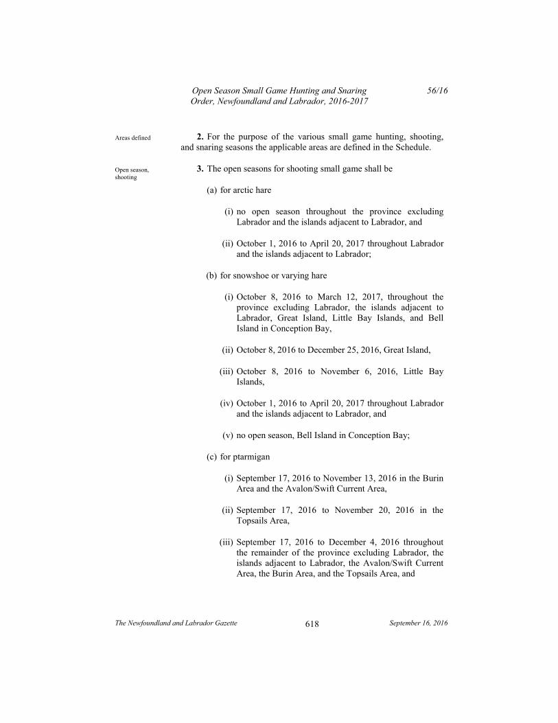
Open Season Small Game Hunting and Snaring Order, Newfoundland and Labrador, 2016-2017
56/16
The Newfoundland and Labrador Gazette September 16, 2016
618
2. For the purpose of the various small game hunting, shooting, and snaring seasons the applicable areas are defined in the Schedule.
3. The open seasons for shooting small game shall be
(a) for arctic hare
(i) no open season throughout the province excluding Labrador and the islands adjacent to Labrador, and
(ii) October 1, 2016 to April 20, 2017 throughout Labrador and the islands adjacent to Labrador;
(b) for snowshoe or varying hare
(i) October 8, 2016 to March 12, 2017, throughout the province excluding Labrador, the islands adjacent to Labrador, Great Island, Little Bay Islands, and Bell Island in Conception Bay,
(ii) October 8, 2016 to December 25, 2016, Great Island,
(iii) October 8, 2016 to November 6, 2016, Little Bay Islands,
(iv) October 1, 2016 to April 20, 2017 throughout Labrador and the islands adjacent to Labrador, and
(v) no open season, Bell Island in Conception Bay;
(c) for ptarmigan
(i) September 17, 2016 to November 13, 2016 in the Burin Area and the Avalon/Swift Current Area,
(ii) September 17, 2016 to November 20, 2016 in the Topsails Area,
(iii) September 17, 2016 to December 4, 2016 throughout the remainder of the province excluding Labrador, the islands adjacent to Labrador, the Avalon/Swift Current Area, the Burin Area, and the Topsails Area, and
Areas defined
Open season, shooting
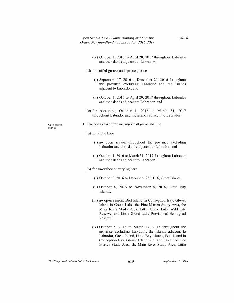
Open Season Small Game Hunting and Snaring Order, Newfoundland and Labrador, 2016-2017
56/16
The Newfoundland and Labrador Gazette September 16, 2016
619
(iv) October 1, 2016 to April 20, 2017 throughout Labrador and the islands adjacent to Labrador;
(d) for ruffed grouse and spruce grouse
(i) September 17, 2016 to December 25, 2016 throughout the province excluding Labrador and the islands adjacent to Labrador, and
(ii) October 1, 2016 to April 20, 2017 throughout Labrador and the islands adjacent to Labrador; and
(e) for porcupine, October 1, 2016 to March 31, 2017 throughout Labrador and the islands adjacent to Labrador.
4. The open season for snaring small game shall be
(a) for arctic hare
(i) no open season throughout the province excluding Labrador and the islands adjacent to Labrador, and
(ii) October 1, 2016 to March 31, 2017 throughout Labrador and the islands adjacent to Labrador;
(b) for snowshoe or varying hare
(i) October 8, 2016 to December 25, 2016, Great Island,
(ii) October 8, 2016 to November 6, 2016, Little Bay Islands,
(iii) no open season, Bell Island in Conception Bay, Glover Island in Grand Lake, the Pine Marten Study Area, the Main River Study Area, Little Grand Lake Wild Life Reserve, and Little Grand Lake Provisional Ecological Reserve,
(iv) October 8, 2016 to March 12, 2017 throughout the province excluding Labrador, the islands adjacent to Labrador, Great Island, Little Bay Islands, Bell Island in Conception Bay, Glover Island in Grand Lake, the Pine Marten Study Area, the Main River Study Area, Little
Open season, snaring
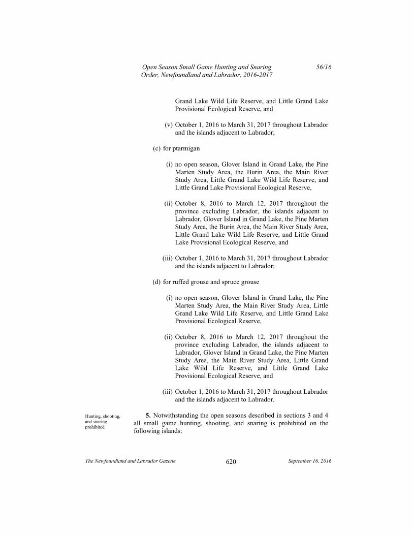
Open Season Small Game Hunting and Snaring Order, Newfoundland and Labrador, 2016-2017
56/16
The Newfoundland and Labrador Gazette September 16, 2016
620
Grand Lake Wild Life Reserve, and Little Grand Lake Provisional Ecological Reserve, and
(v) October 1, 2016 to March 31, 2017 throughout Labrador and the islands adjacent to Labrador;
(c) for ptarmigan
(i) no open season, Glover Island in Grand Lake, the Pine Marten Study Area, the Burin Area, the Main River Study Area, Little Grand Lake Wild Life Reserve, and Little Grand Lake Provisional Ecological Reserve,
(ii) October 8, 2016 to March 12, 2017 throughout the province excluding Labrador, the islands adjacent to Labrador, Glover Island in Grand Lake, the Pine Marten Study Area, the Burin Area, the Main River Study Area, Little Grand Lake Wild Life Reserve, and Little Grand Lake Provisional Ecological Reserve, and
(iii) October 1, 2016 to March 31, 2017 throughout Labrador and the islands adjacent to Labrador;
(d) for ruffed grouse and spruce grouse
(i) no open season, Glover Island in Grand Lake, the Pine Marten Study Area, the Main River Study Area, Little Grand Lake Wild Life Reserve, and Little Grand Lake Provisional Ecological Reserve,
(ii) October 8, 2016 to March 12, 2017 throughout the province excluding Labrador, the islands adjacent to Labrador, Glover Island in Grand Lake, the Pine Marten Study Area, the Main River Study Area, Little Grand Lake Wild Life Reserve, and Little Grand Lake Provisional Ecological Reserve, and
(iii) October 1, 2016 to March 31, 2017 throughout Labrador and the islands adjacent to Labrador.
5. Notwithstanding the open seasons described in sections 3 and 4 all small game hunting, shooting, and snaring is prohibited on the following islands:
Hunting, shooting, and snaring prohibited
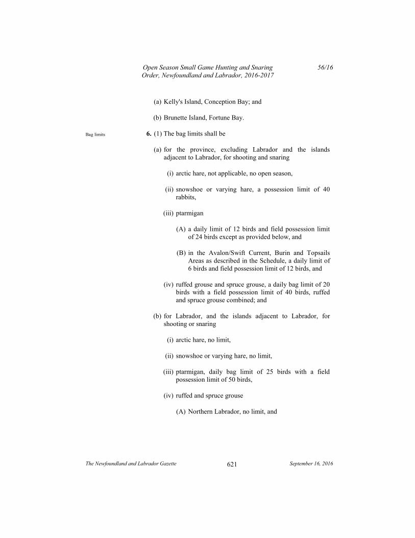
Open Season Small Game Hunting and Snaring Order, Newfoundland and Labrador, 2016-2017
56/16
The Newfoundland and Labrador Gazette September 16, 2016
621
(a) Kelly's Island, Conception Bay; and
(b) Brunette Island, Fortune Bay.
6. (1) The bag limits shall be
(a) for the province, excluding Labrador and the islands adjacent to Labrador, for shooting and snaring
(i) arctic hare, not applicable, no open season,
(ii) snowshoe or varying hare, a possession limit of 40 rabbits,
(iii) ptarmigan
(A) a daily limit of 12 birds and field possession limit of 24 birds except as provided below, and
(B) in the Avalon/Swift Current, Burin and Topsails Areas as described in the Schedule, a daily limit of 6 birds and field possession limit of 12 birds, and
(iv) ruffed grouse and spruce grouse, a daily bag limit of 20 birds with a field possession limit of 40 birds, ruffed and spruce grouse combined; and
(b) for Labrador, and the islands adjacent to Labrador, for shooting or snaring
(i) arctic hare, no limit,
(ii) snowshoe or varying hare, no limit,
(iii) ptarmigan, daily bag limit of 25 birds with a field possession limit of 50 birds,
(iv) ruffed and spruce grouse
(A) Northern Labrador, no limit, and
Bag limits
Open Season Small Game Hunting and Snaring Order, Newfoundland and Labrador, 2016-2017
56/16
The Newfoundland and Labrador Gazette September 16, 2016
622
(B) Southern Labrador, daily bag limit of 25 with field possession limit of 50 birds, spruce and ruffed grouse combined, and
(v) porcupine, a possession limit of one porcupine.
(2) Notwithstanding subparagraph (1)(a)(ii), the possession limit does not apply to persons licensed under the Food and Drug Act (Canada), who may exceed the bag limit for snowshoe hare on their business premises for commercial purposes.
7. A resident who has resided permanently in the Torngat Mountains Electoral District for a period of not less than 6 consecutive months immediately prior to applying for the licence, may be issued a small game licence free of charge.
8. Field possession limit refers to the number of birds a small game licence holder may carry while hunting or travelling in the country.
9. A person shall not transport or possess any firearm under the authority of a valid hunting licence without being in possession of an outdoor identification card, or non-resident equivalent, issued to the person.
10. Hunting with a firearm on Sundays shall be permitted across the entire province, beginning October 2, 2016 and ending April 30, 2017, for the species and during the seasons as described in this Order, including any prescribed season for wild geese, wild ducks and snipe.
11. Approved snaring devices for the province excluding Labrador and the islands adjacent to Labrador may only include
(a) single brass wire not larger than 22 gauge; and
(b) 6 strand braided wire.
12. The Open Season Small Game Hunting and Snaring Order, Newfoundland and Labrador, 2015-2016, Newfoundland and Labrador Regulation 62/15, is repealed.
Small game licence
Field possession limit
Prohibition
Sunday hunting
Approved snaring devices
Repeal

Open Season Small Game Hunting and Snaring Order, Newfoundland and Labrador, 2016-2017
56/16
The Newfoundland and Labrador Gazette September 16, 2016
623
Schedule
(a) Avalon/Swift Current Area
All that area of the Island of Newfoundland bounded by a line beginning at Friar Head in Fortune Bay;
Then northward following the eastern shoreline of Long Harbour and the Long Harbour River a distance of approximately 40 kilometres to the location where the Bay d'Espoir transmission line crosses the Long Harbour River;
Then following straight lines to the Tolt and the northern extremity of Whitehead Pond;
Then following the north shore of Whitehead Pond and the eastern shore of Pipers Hole River to Route 210;
Then following Route 210 to Goobies on the Trans Canada Highway;
Then following the Trans Canada Highway in a southerly direction to its junction with the local road providing access to the community of Sunnyside;
Then following the local road providing access to the Town of Sunnyside to the shoreline of Trinity Bay;
Then following the shorelines of Trinity, Conception, St. Mary's and Placentia Bays to the point where the shoreline meets the Piper's Hole River, thence following the eastern shoreline of the Piper's Hole River in a general northerly direction to the bridge that crosses the Burin Peninsula Highway, Route 210;
Then following Route 210 in a generally southerly direction to its intersection with the Terrenceville Highway;
Then following the north side of the Terrenceville highway to the shoreline of Fortune Bay;
Open Season Small Game Hunting and Snaring Order, Newfoundland and Labrador, 2016-2017
56/16
The Newfoundland and Labrador Gazette September 16, 2016
624
Then following the shoreline of Fortune Bay to the point of commencement, including all offshore islands lying counter-clockwise from Friar Head, Fortune Bay, to the community of Sunnyside, Trinity Bay.
(b) Burin Area
All that area of the Island of Newfoundland bounded by a line beginning at the community of Terrenceville;
Then following the Terrenceville Highway to its intersection with the Burin Peninsula Highway Route 210;
Then following Route 210 in a generally northerly direction to where it crosses the bridge on the Piper's Hole River;
Then following the eastern shore of Piper's Hole River in a southerly direction to its mouth in Placentia Bay;
Then following the shoreline of Placentia and Fortune Bay to the point of commencement, excluding all offshore islands.
(c) The Topsails
All that area of the Island of Newfoundland bounded by a line beginning at the mouth of Hinds Brook in Grand Lake;
Then following the southeastern shoreline of Grand Lake, Sandy Lake and Birchy Lake to the eastern end of Birchy Lake;
Then following a straight line to the closest point on the Trans Canada Highway;
Then following the Trans Canada Highway in a generally easterly and southerly direction to Badger;
Then following a straight line to the closest point on the south bank of the Exploits River;
Then following the Exploits River to Exploits Dam;
Open Season Small Game Hunting and Snaring Order, Newfoundland and Labrador, 2016-2017
56/16
The Newfoundland and Labrador Gazette September 16, 2016
625
Then following the shoreline of Red Indian Lake in first, a generally northerly direction and then, a westerly direction to the mouth of Buchan's Brook;
Then following Buchan's Brook to Buchan's Lake;
Then following the western shoreline of Buchan's Lake to its northwestern extremity;
Then following a straight line to the southeastern extremity of Hind's Lake;
Then following the eastern shoreline of Hind's Lake to its outlet in Hind's Brook;
Then following the south bank of Hind's Brook to the point of commencement.
(d) Northern Labrador Zone
All that portion of Labrador, including adjacent islands, north of a line commencing at a point on the Labrador coast at 54° north latitude;
Then following the westerly line of 54° north latitude to a point where this line intersects with 62° west longitude;
Then following a northerly direction along the 62° west longitude line to a point where it intersects with the 55° north latitude line;
Then following the 55° north latitude line in a westerly direction to a point where it intersects with the Quebec/Labrador border;
Then following the Labrador-Quebec Boundary in a northerly and easterly direction to a point where this boundary intersects 58° 26' 37.8" north latitude;
Then following a straight line in a south-easterly direction for 11941 metres to a point located at 58° 22' 14.2" north latitude and 63° 42' 2.3" west longitude;
Open Season Small Game Hunting and Snaring Order, Newfoundland and Labrador, 2016-2017
56/16
The Newfoundland and Labrador Gazette September 16, 2016
626
Then following a straight line in a north-easterly direction for 15097 metres to a point located at 58° 25' 31.5" north latitude and 63° 27' 51.9" west longitude;
Then following a straight line for 8960 metres in a north-easterly direction to a point where this boundary intersects 58° 28' 12.5" north latitude and coast line of mainland Labrador.
(e) Southern Labrador Zone
All that portion of Labrador, including adjacent islands, lying to the south of a line commencing at a point on the Labrador coast at 54° north latitude;
Then following the westerly line of 54° north latitude to a point where this line intersects with 62° west longitude;
Then following a northerly direction along the 62° west longitude line to a point where it intersects with the 55° north latitude line;
Then following the 55° north latitude line in a westerly direction to a point where it intersects with the Quebec/Labrador border.
(f) Pine Marten Study Area
All that part of the Island of Newfoundland bounded by a line beginning at the intersection of the Trans Canada Highway, Route 1, and the Camp 33 Road;
Then following the Camp 33 Road to the southwestern extremity of Grand Lake;
Then following the shoreline of Grand Lake to the mouth of Red Indian Brook;
Then following the southern bank of Red Indian Brook a distance of approximately 15 kilometres to a small lake on its headwaters;
Open Season Small Game Hunting and Snaring Order, Newfoundland and Labrador, 2016-2017
56/16
The Newfoundland and Labrador Gazette September 16, 2016
627
Then following a straight line in a generally southeasterly direction to the southeastern extremity of Lake of the Hills;
Then following the western bank of the brook flowing out of Lake of the Hills to Otter Pond;
Then following the western shore of Otter Pond and the western bank of the brook flowing out of Otter Pond into Lloyds River;
Then following the northern bank of Lloyds River and the northern shore of Lloyds Lake and the northern bank of Lloyds River, west of Lloyds Lake, to the mouth of the brook flowing out of Cormacks Lake;
Then following the eastern or northern bank of this brook to Cormacks Lake;
Then following a straight line in a generally northerly direction approximately 8 kilometres to a point on the headwaters of Little Barachois Brook;
Then following the northern bank of Little Barachois Brook to its intersection with the eastern boundary of the Barachois Pond Provincial Park;
Then following the eastern and northern boundaries of the park to the Trans Canada Highway;
Then following the Trans Canada Highway to the point of commencement.
(g) Main River Study Area
All that area of the Island of Newfoundland, commencing at a tributary on Main River UTM 481,975 metres east 5,522,600 metres north;
Then following this tributary in a generally northerly direction to UTM 483,840 metres east 5,528,225 metres north;
Open Season Small Game Hunting and Snaring Order, Newfoundland and Labrador, 2016-2017
56/16
The Newfoundland and Labrador Gazette September 16, 2016
628
Then following a straight line in a southeasterly direction to UTM 488,460 metres east 5,525,000 metres north;
Then following a straight line in an easterly direction to the eastern extremity of a small pond at UTM 498,485 metres east 5,525,000 metres north;
Then following the eastern shoreline of the pond to its outlet;
Then following a chain of brooks in a southerly direction to UTM 498,771 metres east 5,522,615 metres north;
Then following a straight line in a generally southeasterly direction to UTM 502,332 metres east 5,518,590 metres north;
Then following a straight line in a generally southwesterly direction to UTM 499,538 metres east 5,516,260 metres north;
Then following a straight line in a southerly direction to the outlet of a small pond at UTM 499,615 metres east 5,513,620 metres north;
Then following a stream that flows in a southerly direction to Main River;
Then following Main River in a westerly direction to a small tributary at UTM 495,570 metres east 5,510,540 metres north;
Then following the tributary and a chain of ponds in a generally westerly direction to where a small stream is intersected by the Upper Humber Forest Access Road at UTM 480,650 metres east 5,509,735 metres north;
Then following a straight line in a westerly direction to the east shore of a small pond at UTM 469,023 metres east 5,510,070 metres north;
Then following the north side of the pond and a connecting tributary in a northwesterly direction to its intersection with
Open Season Small Game Hunting and Snaring Order, Newfoundland and Labrador, 2016-2017
56/16
The Newfoundland and Labrador Gazette September 16, 2016
629
the eastern boundary of Gros Morne National Park at UTM 466,335 metres east 5,510,602 metres north;
Then following the boundary of the park in a northerly direction to where it intersects a lake at UTM 461,750 metres east 5,529,000 metres north;
Then following the south shoreline of the lake in an easterly direction to its most eastern extremity;
Then following a straight line in an easterly direction to UTM 466,087 metres east 5,528,540 metres north;
Then following the southern shore of Parsons Pond River in an easterly direction to the point of commencement.
(h) Northwest Grand Lake Area
All that area of the Island of Newfoundland bounded by a line beginning at the intersection of the Trans Canada Highway, TCH, Route 1 and Camp 33 Road;
Then following Camp 33 Road to the southwest extremity of Grand Lake;
Then following the north shoreline of Grand Lake in a northeasterly direction to the Humber Canal;
Then following the south bank of the Humber Canal to its intersection with the TCH at Deer Lake;
Then following the TCH in a southwesterly direction to the point of commencement.
(i) Terra Nova Area
All that area of the Island of Newfoundland bounded by a line beginning at the intersection of North West River and the Terra Nova National Park, TNNP, boundary at UTM coordinates 706,250 metres east and 5,365,250 metres north;
Open Season Small Game Hunting and Snaring Order, Newfoundland and Labrador, 2016-2017
56/16
The Newfoundland and Labrador Gazette September 16, 2016
630
Then following the north bank of the said river in a westerly direction to UTM coordinates 664,125 metres east and 5,346,625 metres north;
Then following a straight line in a northwesterly direction to UTM coordinates 663,750 metres east and 5,353,125 metres north;
Then following a straight line in a westerly direction to the northeastern extremity of Kepenkeck Lake;
Then following a straight line in a northwesterly direction to the eastern extremity of Newton's Lake;
Then following a straight line in a northerly direction to the eastern extremity of South West Pond;
Then following a straight line in a northeasterly direction to the western extremity of Dead Wolf Pond;
Then following the southern shoreline of Dead Wolf Pond to the mouth of a small stream entering the pond at its eastern extremity;
Then following this stream to its headwaters pond;
Then following a straight line for approximately 500 metres due east to an unnamed pond;
Then following a stream exiting this pond at its southeastern extremity;
Then following this stream in a southeasterly direction to its outflow in Riverhead Brook;
Then following this brook in an easterly direction to its mouth in Gambo Pond;
Then following the north shore of Gambo Pond to Gambo Brook;
Then following the west bank of Gambo Brook to its intersection with the Trans Canada Highway, TCH, Route l;

Open Season Small Game Hunting and Snaring Order, Newfoundland and Labrador, 2016-2017
56/16
The Newfoundland and Labrador Gazette September 16, 2016
631
Then following the TCH in an easterly direction to its intersection with the TNNP boundary;
Then following the western boundary of TNNP in a southerly direction to the point of commencement.
(j) Charlottetown Enclave Area
All that area of the island of Newfoundland bounded by a line beginning at the intersection of the Terra Nova National Park, TNNP, boundary and the north shoreline of Clode Sound, Bonavista Bay at UTM coordinates 720,554 metres east and 5,367,279 metres north;
Then following the TNNP boundary in a northerly direction to UTM coordinates 720,507 metres east and 5,370,209 metres north;
Then following the TNNP boundary in a northeasterly direction to UTM coordinates 721,554 metres east and 5,371,792 metres north;
Then following the TNNP boundary in a southeasterly direction to its intersection with the north shoreline of Clode Sound, Bonavista Bay at UTM coordinates 722,550 metres east and 5,369,850 metres north;
Then following the shoreline of Clode Sound, Bonavista Bay in a southwesterly direction to the point of commencement.
(k) Red Indian Lake Area
All that area of the Island of Newfoundland bounded by a line beginning at the mouth of Victoria River and Red Indian Lake;
Then following the north bank of Victoria River in a southwesterly direction to Victoria Lake;
Then following a mid-way line between the north and south shorelines of Victoria Lake to the mouth of a small river entering Victoria Lake at its southwestern extremity;
Open Season Small Game Hunting and Snaring Order, Newfoundland and Labrador, 2016-2017
56/16
The Newfoundland and Labrador Gazette September 16, 2016
632
Then following the north bank of the Victoria River to a point opposite the mouth of a brook flowing from Peter Strides Pond;
Then following a straight line in a northerly direction to the intersection of the Pine Marten Study Area and Lloyds River at the mouth of the brook flowing from Cormack Lake;
Then following the Pine Marten Study Area boundary along Lloyds River in a northeasterly direction to the mouth of Otter Pond Brook;
Then following the western bank of Otter Pond Brook, the western shore of Otter Pond and the west bank of Otter Pond Brook to Lake of the Hills;
Then following a straight line in a northwesterly direction to UTM co-ordinates 471,250 metres east and 5,379,000 metres north;
Then following a straight line in a northeasterly direction to its intersection with Clench Brook at UTM co-ordinates 500,875 metres east and 5,401,000 metres north;
Then following the south bank of Clench Brook to its mouth on Red Indian Lake;
Then following a straight line in an easterly direction to the point of commencement.
(l) Little Grand Lake Provisional Ecological Reserve
All those pieces or parcels of land situate and being in the Grand Lake Area in the Electoral Districts of St. George's-Stephenville East, Grand Falls-Buchans, Humber East and Humber West abutted and bounded as follows:
Beginning at a point on the northerly bank of a brook, that point having scaled UTM coordinates of north 5,389,704 metres and east 475,606 metres;
Then running along the northerly bank of the brook in a northwesterly direction to a point where a brook flows from
Open Season Small Game Hunting and Snaring Order, Newfoundland and Labrador, 2016-2017
56/16
The Newfoundland and Labrador Gazette September 16, 2016
633
another pond having scaled UTM coordinates of north 5,391,161 metres and east 471,747 metres;
Then running along the northerly shoreline of the pond at low water to a point where a brook flows into the pond having scaled UTM coordinates of north 5,391,994 metres and east 468,930 metres;
Then running in a northwesterly direction to a point having scaled UTM coordinates of north 5,393,183 metres and east 465,520 metres;
Then running in a northwesterly direction to a point having scaled UTM coordinates of north 5,400,550 metres and east 461,818 metres;
Then running in a northwesterly direction to a point having scaled UTM coordinates of north 5,401,539 metres and east 459,751 metres;
Then running in a southwesterly direction to a point on the southerly bank of Red Indian Brook having scaled UTM coordinates of north 5,399,545 metres and east 458,685 metres;
Then running in a southerly direction to a point on the northeasterly shoreline of a pond at low water having scaled UTM coordinates of north 5,393,776 metres and east 458,755 metres;
Then running in a southerly direction to a point on the easterly shoreline of a pond at low water having scaled UTM coordinates of north 5,393,397 metres and east 458,545 metres;
Then running in a southwesterly direction to a point on the northwest corner of a pond at low water having scaled UTM coordinates of north 5,391,346 metres and east 456,746 metres;
Then running along the westerly shoreline of the pond at low water to a point having scaled UTM coordinates of north 5,390,383 metres and east 456,748 metres;
Open Season Small Game Hunting and Snaring Order, Newfoundland and Labrador, 2016-2017
56/16
The Newfoundland and Labrador Gazette September 16, 2016
634
Then running in a southwesterly direction to a point in the southeast corner of a pond at low water having scaled UTM coordinates of north 5,387,341 metres and east 454,904 metres;
Then running in a southwesterly direction to a point on the northerly shoreline of a pond at low water having scaled UTM coordinates of north 5,385,866 metres and east 454,268;
Then running in a southwesterly direction to a point having scaled UTM coordinates of north 5,385,659 metres and east 453,667 metres;
Then running in a northwesterly direction to a point on the easterly shoreline of a pond at low water having scaled UTM coordinates of north 5,386,696 metres and east 453,239 metres;
Then running in a southwesterly direction to a point on the easterly shoreline of Little Lake at low water having scaled UTM coordinates of north 5,385,557 metres and east 450,243 metres;
Then running along the southerly shoreline of Little Lake at low water to a point on the westerly shoreline having scaled UTM coordinates of north 5,385,020 metres and east 449,247 metres;
Then running in a northwesterly direction to a point on the easterly shoreline of a pond at low water having scaled UTM coordinates of north 5,389,792 metres and east 443,369 metres;
Then running in a westerly direction to a point having scaled UTM coordinates of north 5,389,495 metres and east 442,190 metres;
Then running in a northeasterly direction to a point having scaled UTM coordinates of north 5,390,412 metres and east 442,989 metres;
Open Season Small Game Hunting and Snaring Order, Newfoundland and Labrador, 2016-2017
56/16
The Newfoundland and Labrador Gazette September 16, 2016
635
Then running in a northeasterly direction to a point on the southeasterly shoreline of Grand Lake at low water having scaled UTM coordinates of north 5,391,958 metres and east 444,342 metres;
Then running in a southwesterly direction along the southeasterly shoreline of Grand Lake at low water and along the mouth of Lewaseechjeech Brook to a point on the westerly bank of the Lewasheechjeech Brook having scaled UTM coordinates of north 5,386,804 metres and east 430,235 metres;
Then running along the westerly bank of Lewaseechjeech Brook at low water in a southerly direction to a point on the westerly bank of a brook flowing into the Lewaseechjeech Brook having scaled UTM coordinates of north 5,385,643 metres and east 429,908 metres;
Then running along the westerly bank of the brook and along the westerly shoreline of a pond at low water in a southerly direction to a point on the southerly shoreline of the pond having scaled UTM coordinates of north 5,383,359 metres and east 429,072 metres;
Then running in a southerly direction to a point on the northerly shoreline of another pond at low water having scaled UTM coordinates of north 5,382,971 metres and east 428,980 metres;
Then running along the westerly shoreline of the pond at low water and along the westerly bank of a brook in a southerly direction to a point on the westerly shoreline of a small pond having scaled UTM coordinates of north 5,379,559 metres and east 428,242 metres;
Then running in a southeasterly direction to a point on the northwest corner of the shoreline at low water of a pond contained in Bottom Brook having scaled UTM coordinates of north 5,377,444 metres and east 428,570 metres;
Then running along the westerly shoreline at low water of the pond in a southerly direction to a point on the southwest

Open Season Small Game Hunting and Snaring Order, Newfoundland and Labrador, 2016-2017
56/16
The Newfoundland and Labrador Gazette September 16, 2016
636
corner having scaled UTM coordinates of north 5,377,244 metres and east 428,647 metres;
Then running in a southeasterly direction to a point on the northerly shoreline of a pond at low water where a brook flows into the pond having scaled UTM coordinates of north 5,375,629 metres and east 429,663 metres;
Then running in a northerly direction to a point on the southerly bank of Bottom Brook having scaled UTM coordinates of north 5,377,651 metres and east 429,375 metres;
Then running along the southerly bank of Bottom Brook in a northeasterly direction to a point on the western shoreline of a pond at low water having scaled UTM coordinates of north 5,378,006 metres and east 429,789 metres;
Then running in a southeasterly direction to a point on the westerly shoreline of Island Pond at low water having scaled UTM coordinates of north 5,376,000 metres and east 434,641 metres;
Then running along the westerly shoreline of Island Pond at low water in a southeasterly direction to a point having scaled UTM coordinates of north 5,374,939 metres and east 435,872 metres;
Then running in a southeasterly direction to a point on the southerly shoreline of Island Pond at low water having scaled UTM coordinates of north 5,374,236 metres and east 437,560 metres;
Then running along the southerly shoreline of Island Pond at low water to a point having scaled UTM coordinates of north 5,374,019 metres and east 438,975 metres;
Then running in a southeasterly direction to a point on the southerly shoreline of a pond at low water having scaled UTM coordinates of north 5,373,738 metres and east 441,754 metres;
Open Season Small Game Hunting and Snaring Order, Newfoundland and Labrador, 2016-2017
56/16
The Newfoundland and Labrador Gazette September 16, 2016
637
Then running in a southeasterly direction to a point on the westerly shoreline of a pond at low water having scaled UTM coordinates of north 5,373,680 metres and east 443,916 metres;
Then running along the northerly shoreline of the pond to a point having scaled UTM coordinates of north 5,373,688 metres and east 444,159 metres;
Then running in a northeasterly direction to a point on the westerly shoreline of a pond at low water having scaled coordinates of north 5,374,221 metres and east 447,675 metres;
Then running along the northerly shoreline of the pond at low water to a point on the easterly shoreline having scaled UTM coordinates of north 5,374,053 metres and east 448,399 metres;
Then running in a southeasterly direction to a point on the easterly shoreline of a pond at low water having scaled UTM coordinates of north 5,373,326 metres and east 452,037 metres;
Then running in a southeasterly direction to a point on the southerly bank of a brook flowing into Little Grand Lake having scaled UTM coordinates of north 5,373,018 metres and east 458,454 metres;
Then running along the southerly bank of the brook and along the southeasterly shoreline of a pond at low water in a northeasterly direction to a point having scaled UTM coordinates north 5,374,178 metres and east 464,746 metres;
Then running in a northeasterly direction to a point on a hilltop having scaled UTM coordinates of north 5,380,135 metres and east 470,561 metres;
Then running in a northeasterly direction to the point of beginning;
The above described piece or parcel of land containing an area of 692.97 kilometres squared, more or less;
Open Season Small Game Hunting and Snaring Order, Newfoundland and Labrador, 2016-2017
56/16
The Newfoundland and Labrador Gazette September 16, 2016
638
Also, all that other piece or parcel of land containing an area of 1.67 kilometres squared, more or less; abutted and bounded as follows:
Beginning at a point on the westerly bank of the Lewaseechjeech Brook at low water, the point having scaled UTM coordinates of north 5,386,804 metres and east 430,235 metres;
Then running along the westerly bank of Lewaseechjeech Brook and along the southwesterly shoreline of Grand Lake at low water in a northwesterly direction to a point on the southerly shoreline having scaled UTM coordinates of north 5,389,218 metres and east 427,412 metres;
Then running in a southeasterly direction to a point on the northerly shoreline of a pond at low water having scaled UTM coordinates of north 5,388,300 metres and east 428,197 metres;
Then running along the northerly shoreline of the pond at low water in a southeasterly direction to a point on the southerly shoreline of the pond where a brook flows from the pond having scaled UTM coordinates of north 5,388,234 metres and east 428,300 metres;
Then running in a northeasterly direction to a point on a hill having scaled UTM coordinates of north 5,388,465 metres and east 429,523 metres;
Then running in a southeasterly direction to the point of beginning;
Also, all that other piece or parcel of land containing an area of 34.46 kilometres squared, more or less, abutted and bounded as follows:
Beginning at a point in the northwesterly shoreline of Grand Lake at low water, the point being located west of Sandy Point on the east bank of a brook flowing into Grand Lake and having scaled UTM coordinates of north 5,391,015 metres and east 427,053 metres;
Open Season Small Game Hunting and Snaring Order, Newfoundland and Labrador, 2016-2017
56/16
The Newfoundland and Labrador Gazette September 16, 2016
639
Then running in a northeasterly direction to a point having scaled UTM coordinates of north 5,391,686 metres and east 428,921 metres;
Then running in a northeasterly direction to a point located on the top of a hill and having scaled UTM coordinates of north 5,392,323 metres and east 429,476 metres;
Then running in southeasterly direction to a point having scaled UTM coordinates of north 5,391,432 metres and east 429,759 metres;
Then running in a southeasterly direction to a point having scaled UTM coordinates of north 5,391,495 metres and east 430,805 metres;
Then running in a northeasterly direction to a point in the centre of a brook flowing into Grand Lake having scaled UTM coordinates of north 5,393,643 metres and east 433,459 metres;
Then running in a northeasterly direction to a point in the centre of a brook flowing into Grand Lake having scaled UTM coordinates of north 5,397,098 metres and east 437,193 metres;
Then running in a northeasterly direction to a point in the centre of a brook flowing into Grand Lake having scaled UTM coordinates of north 5,399,507 metres and east 439,105 metres;
Then running in a northeasterly direction to a point having scaled UTM coordinates of north 5,401,328 metres and east 440,774 metres;
Then running in a northerly direction to a point on a hill having scaled UTM coordinates of north 5,401,885 metres and east 440,743 metres;
Then running in a northeasterly direction to a point in the centre of a brook having scaled UTM coordinates of north 5,402,675 metres and east 441,768 metres;
Open Season Small Game Hunting and Snaring Order, Newfoundland and Labrador, 2016-2017
56/16
The Newfoundland and Labrador Gazette September 16, 2016
640
Then running in a northeasterly direction to a point in the centre of a brook having scaled UTM coordinates of north 5,404,217 metres and east 442,789 metres;
Then running in a northeasterly direction to a point on the southwesterly shoreline of a pond at low water having scaled UTM coordinates of north 5,406,758 metres and east 443,055 metres;
Then running along the southerly shoreline of the pond, along the southerly bank of a brook flowing into the pond, and along the southerly shoreline of another pond at low water to a point at the northern end of the pond having scaled UTM coordinates of north 5,409,299 metres and east 444,989 metres;
Then running in a northeasterly direction to a point on the southerly shoreline of a pond at low water having scaled UTM coordinates of north 5,410,781 metres and east 446,292 metres;
Then running along the southerly shoreline of the pond in a northeasterly direction to a point on the easterly shoreline of the pond having scaled UTM coordinates of north 5,411,049 metres and east 446,880 metres;
Then running in an easterly direction to a point on a hill having scaled UTM coordinates of north 5,411,266 metres and east 448,884 metres;
Then running in a northeasterly direction to a point having scaled UTM coordinates of north 5,413,070 metres and east 450,727 metres;
Then running in a northeasterly direction to a point on a hill having scaled UTM coordinates of north 5,415,357 metres and east 451,840 metres;
Then running in a northwesterly direction to a point on the westerly bank of a brook flowing into the Grand Lake having scaled UTM coordinates of north 5,416,303 metres and east 451,029 metres;

Open Season Small Game Hunting and Snaring Order, Newfoundland and Labrador, 2016-2017
56/16
The Newfoundland and Labrador Gazette September 16, 2016
641
Then running along the westerly bank of the brook in a southerly direction to a point on the northerly shoreline of north Northern Harbour, Grand Lake, at low water having scaled UTM coordinates of north 5,415,033 metres and east 452,861 metres;
Then running along the northerly shoreline of Grand Lake at low water in a southwesterly direction to the point of beginning;
Also, all that other piece or parcel of land containing an area of 2.05 kilometres squared abutted and bounded as follows:
Beginning at a point in the northwesterly shoreline of Grand Lake at low water, at the eastern bank of the mouth of a brook flowing into Northern Harbour, the point having scaled UTM coordinates of north 5,416,118 metres and east 453,821 metres;
Then running in a northeasterly direction, perpendicular to the shoreline, to a point having scaled UTM coordinates of north 5,416,284 metres and east 453,857 metres;
Then running in general southerly and northeasterly directions, parallel to and perpendicularly distant 200 metres from the low water mark of Grand Lake, to a point on the westerly bank of Porters Brook having scaled UTM coordinates of north 5,419,213 and east 459,778 metres;
Then running along the low water mark of the westerly bank of Porters Brook to a point where the brook flows into Bucket Cove, Grand Lake, having scaled UTM coordinates of north 5,419,008 metres and east 459,797 metres;
Then running along the northwesterly shoreline of Grand Lake at low water in southwesterly and northeasterly directions to the point of beginning;
The above described piece or parcel of land being subject to a Newfoundland and Labrador Hydro Line Easement, 152.4 metres wide, extending through the parcel;
Open Season Small Game Hunting and Snaring Order, Newfoundland and Labrador, 2016-2017
56/16
The Newfoundland and Labrador Gazette September 16, 2016
642
Reserving nevertheless, out of the above described pieces or parcels of land all roads and adjacent rights of way crossing the parcels;
The above described pieces or parcels of land containing in all an area of 731.15 kilometres squared, more or less.
All bearings being referred to zone 21 of the Universal Transverse Mercator Projection, NAD83.
(m) The Little Grand Lake Wild Life Reserve
All those pieces or parcels of land situate and being south of Grand Lake in the Electoral Districts of St. George's-Stephenville East, Grand Falls-Buchans, and Burgeo and LaPoile abutted and bounded as follows:
Beginning at a point in the southeasterly shoreline of Grand Lake at the low water mark, the point having scaled UTM coordinates of north 5,414,968 metres and east 463,731 metres;
Then running in a southeasterly direction to a point on the westerly bank of a river, the point having scaled UTM coordinates of north 5,393,331 metres and east 477,337 metres;
Then running in a southwesterly direction to a point on the northerly bank of brook, the point having scaled UTM coordinates of north 5,389,704 metres and east 475,606 metres;
Then running along the northerly bank of the brook in a northwesterly direction to a point where the brook flows from a pond having scaled UTM coordinates of north 5,391,161 metres and east 471,747 metres;
Then running along the northerly shoreline of the pond at low water to a point where a brook flows into the pond having scaled UTM coordinates of north 5,391,994 metres and east 468,930 metres;

Open Season Small Game Hunting and Snaring Order, Newfoundland and Labrador, 2016-2017
56/16
The Newfoundland and Labrador Gazette September 16, 2016
643
Then running in a northwesterly direction to a point having scaled UTM coordinates of north 5,393,183 metres and east 465,520 metres;
Then running in a northwesterly direction to a point having scaled UTM coordinates of north 5,400,550 metres and east 461,818 metres;
Then running in a northwesterly direction to a point having scaled UTM coordinates of north 5,401,539 metres and east 459,751 metres;
Then running in a southwesterly direction to a point on the northerly bank of Red Indian Brook having scaled UTM coordinates of north 5,399,545 metres and east 458,685 metres;
Then running in a southerly direction to a point on the northeasterly shoreline of a pond at low water having scaled UTM coordinates of north 5,393,776 metres and east 458,755 metres;
Then running along the easterly shoreline of the pond at low water to a point on the southern shoreline having scaled UTM coordinates of north 5,393,397 metres and east 458,545 metres;
Then running in a southwesterly direction to a point on the northwest corner of a pond at low water having scaled UTM coordinates of north 5,391,346 metres and east 456,746 metres;
Then running along the westerly shoreline of the pond at low water to a point having scaled UTM coordinates of north 5,390,383 metres and east 456,748 metres;
Then running in a southwesterly direction to a point in the southeast corner of a pond at low water having scaled UTM coordinates of north 5,387,341 metres and east 454,904 metres;
Then running in a southwesterly direction to a point on the northerly shoreline of a pond at low water having scaled
Open Season Small Game Hunting and Snaring Order, Newfoundland and Labrador, 2016-2017
56/16
The Newfoundland and Labrador Gazette September 16, 2016
644
UTM coordinates of north 5,385,866 metres and east 454,268 metres;
Then running in a southwesterly direction to a point having scaled UTM coordinates of north 5,385,659 metres and east 453,667 metres;
Then running in a northwesterly direction to a point on the easterly shoreline of a pond at low water having scaled UTM coordinates of north 5,386,696 metres and east 453,239 metres;
Then running in a southwesterly direction to a point on the easterly shoreline of Little Lake at low water having scaled UTM coordinates of north 5,385,557 metres and east 450,243 metres;
Then running along the southerly shoreline of Little Lake at low water to a point on the westerly shoreline having scaled UTM coordinates of north 5,385,020 metres and east 449,247 metres;
Then running in a northwesterly direction to a point on the easterly shoreline of a pond at low water having scaled UTM coordinates of north 5,389,792 and east 443,369 metres;
Then running in a westerly direction to a point having scaled UTM coordinates of north 5,389,495 metres and east 442,190 metres;
Then running in a northeasterly direction to a point having scaled UTM coordinates of north 5,390,412 metres and east 442,989 metres;
Then running in a northeasterly direction to a point on the southeasterly shoreline of Grand Lake at low water having scaled UTM coordinates north 5,391,958 metres and east 444,342 metres;
Then running along the southeasterly shoreline of Grand Lake at low water mark to the point of beginning;
Open Season Small Game Hunting and Snaring Order, Newfoundland and Labrador, 2016-2017
56/16
The Newfoundland and Labrador Gazette September 16, 2016
645
The above described piece or parcel of land being subject to a Newfoundland Hydro Line Easement, 152.4 metres wide, extending through the land;
And containing an area of 391.44 kilometres squared, more or less;
Also, all that other piece or parcel of land containing an area of 172.26 kilometres squared, more or less; abutted and bounded as follows:
Beginning at a point in the southeasterly shoreline of a pond at low water, the point having scaled UTM coordinates of north 5,374,178 metres and east 464,746 metres;
Then running in a southwesterly direction to a point on the southerly shoreline of Padille Pond at low water, the point having scaled UTM coordinates of north 5,369,364 metres and east 458,323 metres;
Then running in a northeasterly direction along the westerly shoreline of Padille Pond to a point on the shoreline at low water having scaled UTM coordinates of north 5,371,058 metres and east 459,214 metres;
Then running in a northwesterly direction to a point on the southerly shoreline of a pond at low water having scaled UTM coordinates of north 5,371,300 metres and east 458,353 metres;
Then running in a southwesterly direction to a point near the eastern shoreline of Bottle Lake having scaled UTM coordinates of north 5,370,708 and east 456,118 metres;
Then running in a southwesterly direction to a point on the northerly shoreline of Puddle Pond at low water having scaled UTM coordinates of north 5,369,402 metres and east 455,632 metres;
Then running along the northerly shoreline of Puddle Pond to a point having scaled UTM coordinates of north 5,369,249 metres and east 457,983 metres;

Open Season Small Game Hunting and Snaring Order, Newfoundland and Labrador, 2016-2017
56/16
The Newfoundland and Labrador Gazette September 16, 2016
646
Then running in a southwesterly direction to a point on the northerly limit of the Newfoundland and Labrador Hydro Transmission line easement, 30 metres wide, having scaled UTM coordinates of north 5,365,128 metres and east 452,633 metres;
Then running along the northerly limit of the transmission line easement in a northwesterly direction to a point on the northerly bank of Southwest Brook at low water having scaled UTM coordinates of north 5,367,004 metres and east 443,702 metres;
Then running along the northerly bank of Southwest Brook at low water in a northwesterly direction to a point where a brook flows into Southwest Brook having scaled UTM coordinates of north 5,368,321 metres and east 441,104 metres;
Then running along the easterly bank of the brook at low water in a northerly direction to a point on the southwesterly shoreline of a pond at low water having scaled UTM coordinates of north 5,368,721 metres and east 441,363 metres;
Then running along the westerly shoreline of the pond at low water to a point on the northerly bank of a brook flowing into the pond having scaled UTM coordinates of north 5,368,804 metres and east 441,312 metres;
Then following the northerly bank of the brook in a northwesterly direction to a point on the southerly shoreline of a pond at low water having scaled UTM coordinates of north 5,370,103 metres and east 440,488 metres;
Then running along the southerly shoreline of the pond in a westerly direction at low water to a point having scaled UTM coordinates of north 5,370,113 metres and east 440,319 metres;
Then running in a westerly direction to a point on the southerly shoreline of a pond at low water having scaled UTM coordinates of north 5,370,006 metres and east 437,505 metres;
Open Season Small Game Hunting and Snaring Order, Newfoundland and Labrador, 2016-2017
56/16
The Newfoundland and Labrador Gazette September 16, 2016
647
Then running along the northerly bank of a brook flowing from the pond to a point where the brook meets another brook and both brooks converge and flow into Southwest Brook having scaled UTM coordinates of north 5,368,550 metres and east 435,535 metres;
Then following the northerly bank of the converging brook at low water in a general northwesterly direction to a point having scaled UTM coordinates of north 5,369,891 metres and east 434,472 metres;
Then running in a northwesterly direction to a point having southerly shoreline of North Lake at low water having scaled UTM coordinates of north 5,371,193 metres and east 433,389 metres;
Then running along the westerly shoreline of North Lake at low water in a northwesterly direction to a point at the northwest corner of North Lake having scaled UTM coordinates of north 5,374,841 metres and east 432,517 metres;
Then running in a northwesterly direction to a point in the southerly shoreline of a pond at low water having scaled UTM coordinates of north 5,375,300 metres and east 432,269 metres;
Then following the northerly bank of a brook flowing from the southerly shoreline of the pond at low water in a westerly direction to the point where the brook flows into the easterly shoreline of another pond having scaled UTM coordinates of north 5,375,545 metres and east 430,361 metres;
Then running along the northerly shoreline of the pond at low water to a point where a brook flows into the pond having scaled UTM coordinates of north 5,375,629 metres and east 429,663 metres;
Then running in a northerly direction to a point on the southerly bank of Bottom Brook having scaled UTM coordinates of north 5,377,651 metres and east 429,375 metres;
Open Season Small Game Hunting and Snaring Order, Newfoundland and Labrador, 2016-2017
56/16
The Newfoundland and Labrador Gazette September 16, 2016
648
Then running along the southerly bank of Bottom Brook in a northeasterly direction to a point on the westerly shoreline of a pond at low water having scaled UTM coordinates of north 5,378,006 metres and east 429,789 metres;
Then running in a southeasterly direction to a point on the westerly shoreline of Island Pond at low water having scaled UTM coordinates of north 5,376,000 metres and east 434,641 metres;
Then running along the westerly shoreline of Island Pond at low water in a southeasterly direction to a point having scaled UTM coordinates of north 5,374,939 metres and east 435,872 metres;
Then running in a southeasterly direction to a point on the southerly shoreline of Island Pond at low water having scaled UTM coordinates of north 5,374,236 metres and east 437,560 metres;
Then running along the southerly shoreline of Island Pond at low water to a point having scaled UTM coordinates of north 5,374,019 metres and east 438,975 metres;
Then running in a southeasterly direction to a point on the southerly shoreline of a pond at low water having scaled UTM coordinates of north 5,373,738 metres and east 441,754 metres;
Then running in a southeasterly direction to a point of the westerly shoreline of a pond at low water having scaled UTM coordinates of north 5,373,680 metres and east 443,916 metres;
Then running along the northerly shoreline of the pond at low water to a point on the easterly shoreline having scaled UTM coordinates of north 5,373,688 metres and east 444,159 metres;
Then running in a northeasterly direction to a point on the westerly shoreline of a pond at low water having scaled UTM coordinates of north 5,374,221 metres and east 447,675 metres;
Open Season Small Game Hunting and Snaring Order, Newfoundland and Labrador, 2016-2017
56/16
The Newfoundland and Labrador Gazette September 16, 2016
649
Then running along the northerly shoreline of the pond at low water to a point on the easterly shoreline having scaled UTM coordinates of north 5,374,053 metres and east 448,399 metres;
Then running in a southeasterly direction to a point on the easterly shoreline of a pond at low water having scaled UTM coordinates of north 5,373,326 and east 452,037 metres;
Then running in a southeasterly direction to a point on the southerly bank of a brook flowing into Little Grand Lake having scaled UTM coordinates of north 5,373,018 metres and east 458,454 metres;
Then running along the southerly bank of the brook and along the southerly shoreline of a pond at low water in a northeasterly direction to the point of beginning;
Also all that other piece or parcel of land containing an area of 5.10 kilometres squared, more or less, abutted and bounded as follows:
Beginning at a point on the southerly shoreline of Padille Pond at low water, the point having scaled UTM coordinates of north 5,369,364 metres and east 458,323 metres;
Then running in a northeasterly direction along the westerly shoreline of the Padille Pond to a point on the shoreline at low water having scaled UTM coordinates of north 5,371,058 metres and east 459,214 metres;
Then running in a northwesterly direction to a point on the southerly shoreline of a pond at low water having scaled UTM coordinates of north 5,371,300 and east 458,353 metres;
Then running in a southwesterly direction to a point near the eastern shoreline of Bottle Lake having scaled UTM coordinates of north 5,370,708 and east 456,118 metres;
Then running in a southwesterly direction to a point on the northerly shoreline of Puddle Pond at low water having

Open Season Small Game Hunting and Snaring Order, Newfoundland and Labrador, 2016-2017
56/16
The Newfoundland and Labrador Gazette September 16, 2016
650
scaled UTM coordinates of north 5,369,402 metres and east 455,632 metres;
Then running along the northerly shoreline of Puddle Pond at low water to a point having scaled UTM coordinates of north 5,369,249 metres and east 457,983 metres;
Then running in a northeasterly direction to the point of beginning;
Reserving nevertheless out of the above described pieces or parcels of land all roads and adjacent rights of way crossing the parcels;
The above described pieces or parcels of land containing in all an area of 568.80 kilometres squared, more or less;
All bearings being referred to zone 21 of the Universal Transverse Mercator Projection, NAD83.
©Queen's Printer
THE NEWFOUNDLAND AND LABRADOR GAZETTE September 16, 2016
651
Index
PART I
Canada-Newfoundland and Labrador Atlantic Accord Implementation Act and Canada-Newfoundland Atlantic Accord Implementation Newfoundland and Labrador Act – Notice ........................................ 289 Embalmers and Funeral Directors Act, 2008 – Notices ................................................................................................................ 292 Lands Act – Notice ...................................................................................................................................................................... 295 Mineral Act – Notice .................................................................................................................................................................... 290 Trustee Act – Notice ..................................................................................................................................................................... 295
PART II
CONTINUING INDEX OF SUBORDINATE LEGISLATION
Title of Act and Subordinate Legislation CNLR or NL Gazette made thereunder NL Reg. Amendment Date & Page No.
Wildlife Regulations and Wild Life Act Big Game Caribou Order, NLR 49/16 R&S Sept.16/16 p. 451 Labrador, 2016-2017 NLR 55/15 Coyote Hunting Order, NLR 50/16 R&S Sept.16/16 p. 453 Newfoundland and Labrador, NLR 56/15 2016-2017 Furbearing Animals NLR 51/16 R&S Sept.16/16 p. 455 Trapping and Shooting NLR 57/15 Order, Newfoundland and Labrador, 2016-2017 Open Season Big Game NLR 52/16 R&S Sept.16/16 p. 481 Black Bear Hunting NLR 58/15 and Snaring Order, Labrador, 2016-2017 Open Season Big Game NLR 53/16 R&S Sept.16/16 p. 487 Caribou Hunting Order, NLR 59/15 Newfoundland, 2016-2017 Open Season Big Game NLR 54/16 R&S Sept.16/15 p. 509 Moose Hunting Order, NLR 60/15 Labrador, 2016-2017 Open Season Big Game NLR 55/16 R&S Sept.16/16 p. 541 Moose Hunting Order, NLR 61/15 Newfoundland, 2016-2017 Open Season Small Game NLR 56/16 R&S Sept.16/16 p. 617 Hunting and Snaring Order, NLR 62/15 Newfoundland and Labrador, 2016-2017
THE NEWFOUNDLAND AND LABRADOR GAZETTE September 16, 2016
652
All other public notices required by law to be published in The Newfoundland and Labrador Gazette, eg., Corporations Act, Municipalities Act, Quieting of Titles Act, Urban and Rural Planning Act, etc., are priced according to size: for Single Column $3.47 per cm or Double Column $6.93 per cm, plus 15% HST.
The Newfoundland and Labrador Gazette is published from the Office of the Queen’s Printer.
Copy for publication must be received by Friday, 4:30 p.m., seven days before publication date to ensure inclusion in next issue.
Advertisements must be submitted in either PDF format or as a MSWord file. When this is not possible, advertisements must be either, typewritten or printed legibly, separate from covering letter. Number of insertions required must be stated and the names of all signing officers typewritten or printed.
Copy may be mailed to the address below, faxed to (709) 729-1900 or emailed to [email protected].
Subscription rate for The Newfoundland and Labrador Gazette is $144.38 for 52 weeks plus 15% HST ($166.04). Weekly issues, $3.47 per copy, plus 15% HST ($3.99) payable in advance.
All cheques, money orders, etc., should be made payable to THE NEWFOUNDLAND EXCHEQUER ACCOUNT and all correspondence should be addressed to: Office of the Queen’s Printer, P. O. Box 8700, Ground Floor, East Block, Confederation Building, St. John’s, NL A1B 4J6, Telephone: (709) 729-3649, Fax: (709) 729-1900.
Web Site: http://www.servicenl.gov.nl.ca/printer/index.html
The Newfoundland and Labrador Gazette
Advertising Rates Prices effective July 1, 2016
Notices Rate 15% HST Total Lands Act - Notice of Intent - 1 week $31.13 $4.67 $35.80 Motor Carrier Act - Notice - 1 week $39.90 $5.99 $45.89 Trustee Act - Estate Notice - 1 week $34.65 $5.20 $39.85 Trustee Act - Estate Notice - 2 weeks $62.37 $9.36 $71.73 Trustee Act - Estate Notice - 3 weeks $91.25 $13.69 $104.94 Trustee Act - Estate Notice - 4 weeks $118.97 $17.85 $136.82
For quotes please contact the Office of the Queen's Printer [email protected]
Government Information Product
Publication Rate Mail G.S.T. # R107442683