THE NATIONAL ROUTEING GUIDE IN DETAIL -...
20
F1 THE NATIONAL ROUTEING GUIDE IN DETAIL (examples do not use current Routing Guide data) The National Routeing Guide has 6 sections, A, B, C, D, E and F. Section A explains the rules and procedures for using the Routeing Guide and lists routeing point groups created to improve interchange opportunities by offering a wider choice of train services and station amenities. Section B (the pink pages) lists all stations. Some stations are routeing points. Some are members of routeing points groups. The rest are related stations. Stations which are routeing points or members of a routeing point group are printed in capitals. To look up a journey in the Routeing Guide, an origin and destination routeing point are needed. If a journey does not have an origin routeing point and a destination routeing point, its permitted route is (1) the shortest route served by a regular passenger service or (2) a route no more then 3 miles longer or (3) any other route permitted by an easement. A related station cannot be used to look up permitted routes in the Routeing Guide. Only routeing points can be used for that. All related stations are therefore associated with the nearest routeing point or routeing point group in each direction. A related station may have up to 4 associations. Example 1 Penarth has one routeing point, Cardiff Central. Journeys from Penarth to stations beyond Grangetown must go through the routeing point. Station name Associated routeing points 1 2 3 4 Penarth Cardiff Central CARDIFF CENTRAL Penarth Barry Island Grangetown
Transcript of THE NATIONAL ROUTEING GUIDE IN DETAIL -...
F1
THE NATIONAL ROUTEING GUIDE IN DETAIL (examples do not use current Routing Guide data) The National Routeing Guide has 6 sections, A, B, C, D, E and F.
Section A explains the rules and procedures for using the Routeing Guide and listsrouteing point groups created to improve interchange opportunities by offering awider choice of train services and station amenities.
Section B (the pink pages) lists all stations. Some stations are routeing points. Someare members of routeing points groups. The rest are related stations. Stations whichare routeing points or members of a routeing point group are printed in capitals.
To look up a journey in the Routeing Guide, an origin and destination routeing pointare needed. If a journey does not have an origin routeing point and a destinationrouteing point, its permitted route is (1) the shortest route served by a regularpassenger service or (2) a route no more then 3 miles longer or (3) any other routepermitted by an easement.
A related station cannot be used to look up permitted routes in the Routeing Guide.Only routeing points can be used for that. All related stations are thereforeassociated with the nearest routeing point or routeing point group in each direction.A related station may have up to 4 associations.
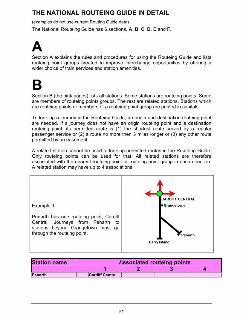
Example 1
Penarth has one routeing point, CardiffCentral. Journeys from Penarth tostations beyond Grangetown must gothrough the routeing point.
Station name Associated routeing points1 2 3 4
Penarth Cardiff Central
CARDIFF CENTRAL
Penarth
Barry Island
Grangetown
F2
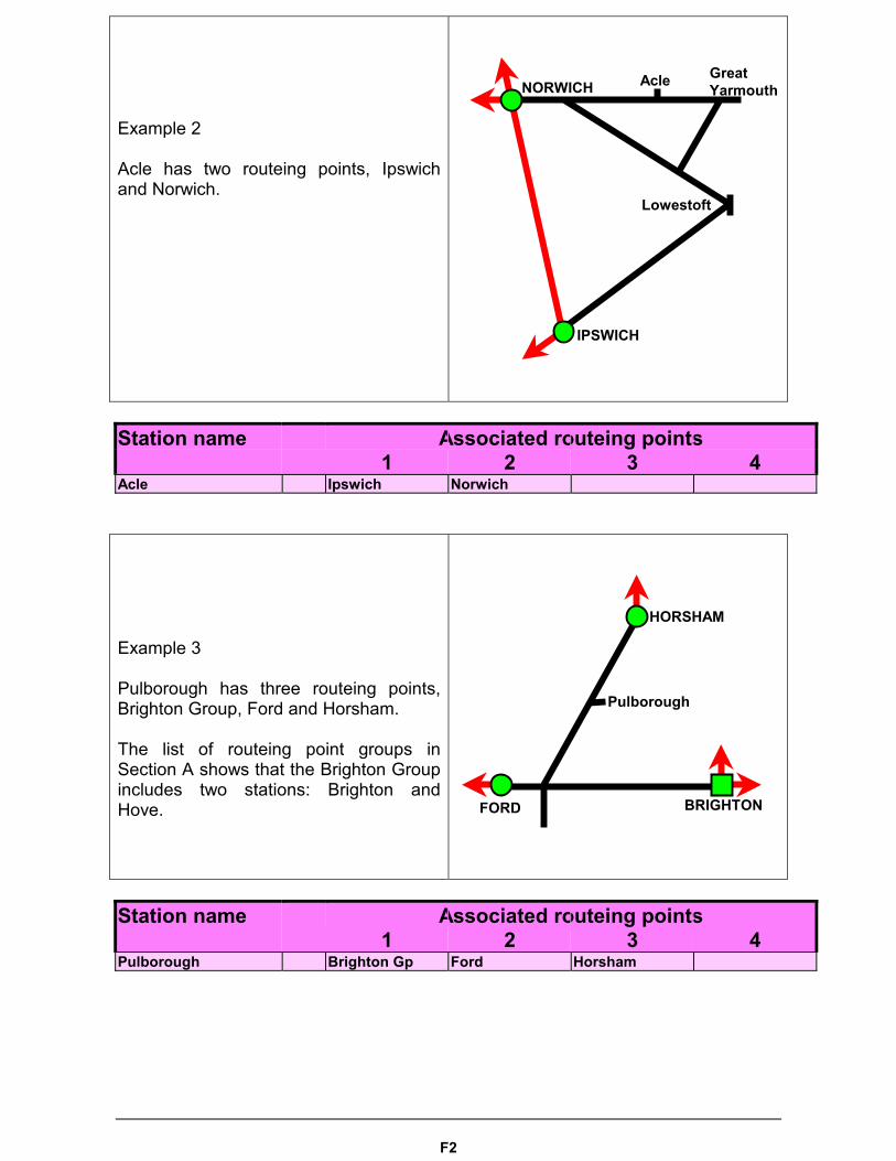
Example 2
Acle has two routeing points, Ipswichand Norwich.
Station name Associated routeing points1 2 3 4
Acle Ipswich Norwich
Example 3
Pulborough has three routeing points,Brighton Group, Ford and Horsham.
The list of routeing point groups inSection A shows that the Brighton Groupincludes two stations: Brighton andHove.
Station name Associated routeing points1 2 3 4
Pulborough Brighton Gp Ford Horsham
NORWICH Acle GreatYarmouth
IPSWICH
Lowestoft
HORSHAM
FORD BRIGHTON
Pulborough
F3
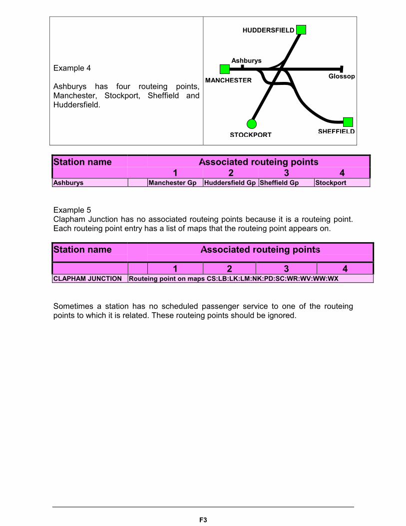
Example 4
Ashburys has four routeing points,Manchester, Stockport, Sheffield andHuddersfield.
Station name Associated routeing points1 2 3 4
Ashburys Manchester Gp Huddersfield Gp Sheffield Gp Stockport
Example 5Clapham Junction has no associated routeing points because it is a routeing point.Each routeing point entry has a list of maps that the routeing point appears on.
Station name Associated routeing points
1 2 3 4CLAPHAM JUNCTION Routeing point on maps CS:LB:LK:LM:NK:PD:SC:WR:WV:WW:WX
Sometimes a station has no scheduled passenger service to one of the routeingpoints to which it is related. These routeing points should be ignored.
MANCHESTER
Ashburys
STOCKPORT
HUDDERSFIELD
SHEFFIELD
Glossop
F4
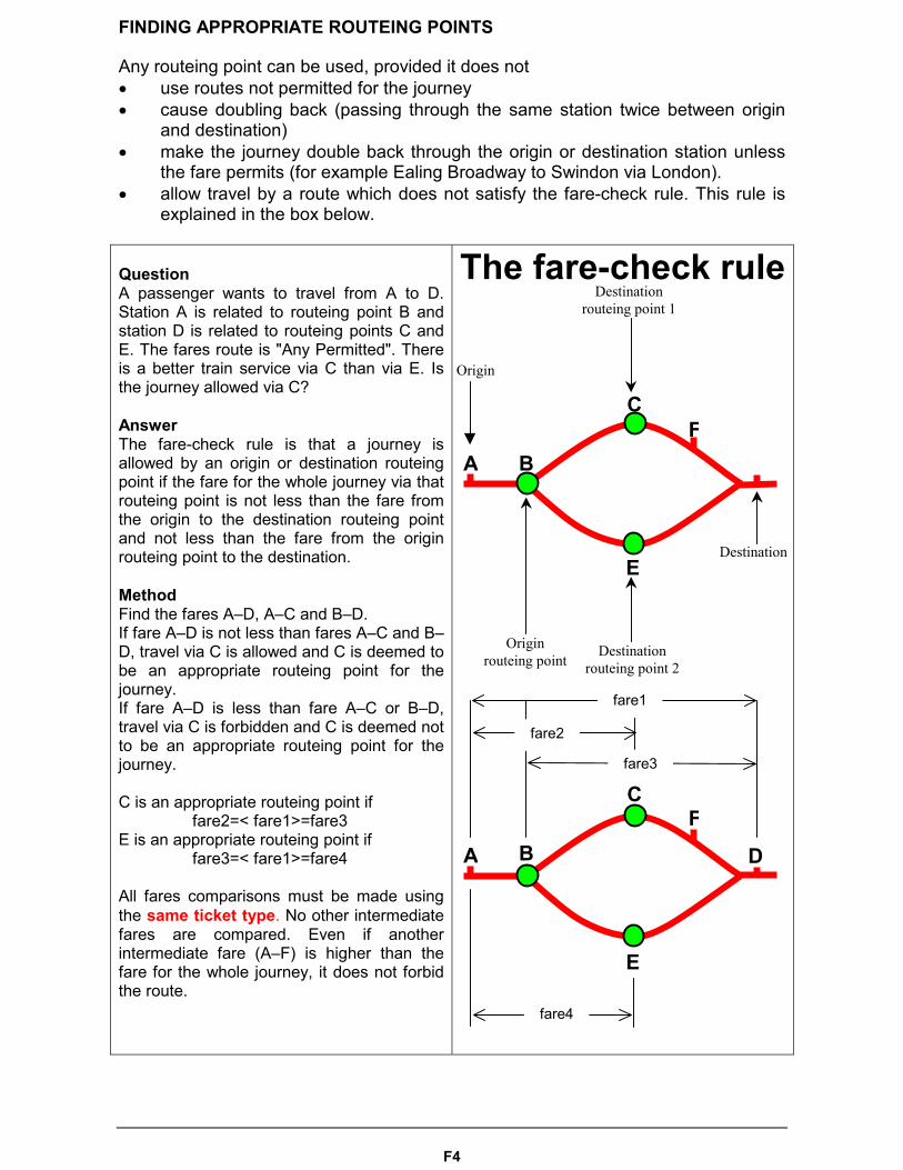
FINDING APPROPRIATE ROUTEING POINTS
Any routeing point can be used, provided it does not� use routes not permitted for the journey� cause doubling back (passing through the same station twice between origin
and destination)� make the journey double back through the origin or destination station unless
the fare permits (for example Ealing Broadway to Swindon via London).� allow travel by a route which does not satisfy the fare-check rule. This rule is
explained in the box below.
QuestionA passenger wants to travel from A to D.Station A is related to routeing point B andstation D is related to routeing points C andE. The fares route is "Any Permitted". Thereis a better train service via C than via E. Isthe journey allowed via C?
AnswerThe fare-check rule is that a journey isallowed by an origin or destination routeingpoint if the fare for the whole journey via thatrouteing point is not less than the fare fromthe origin to the destination routeing pointand not less than the fare from the originrouteing point to the destination.
MethodFind the fares A–D, A–C and B–D.If fare A–D is not less than fares A–C and B–D, travel via C is allowed and C is deemed tobe an appropriate routeing point for thejourney.If fare A–D is less than fare A–C or B–D,travel via C is forbidden and C is deemed notto be an appropriate routeing point for thejourney.
C is an appropriate routeing point if fare2=< fare1>=fare3E is an appropriate routeing point if
fare3=< fare1>=fare4
All fares comparisons must be made usingthe same ticket type. No other intermediatefares are compared. Even if anotherintermediate fare (A–F) is higher than thefare for the whole journey, it does not forbidthe route.
The fare-check rule
C
BA
E
Originrouteing point
Destinationrouteing point 2
Destinationrouteing point 1
Destination
Origin
F
D
C
BA
E
F
fare1
fare2
fare3
fare4
F5
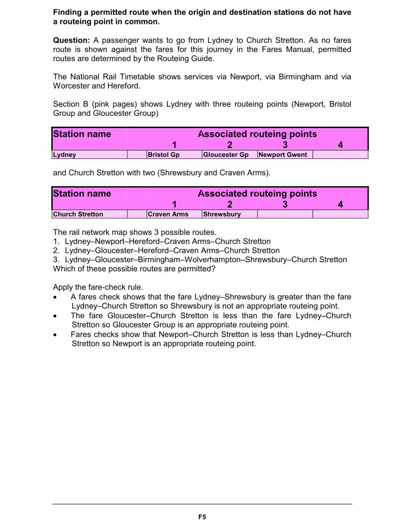
Finding a permitted route when the origin and destination stations do not havea routeing point in common.
Question: A passenger wants to go from Lydney to Church Stretton. As no faresroute is shown against the fares for this journey in the Fares Manual, permittedroutes are determined by the Routeing Guide.
The National Rail Timetable shows services via Newport, via Birmingham and viaWorcester and Hereford.
Section B (pink pages) shows Lydney with three routeing points (Newport, BristolGroup and Gloucester Group)
Station name Associated routeing points1 2 3 4
Lydney Bristol Gp Gloucester Gp Newport Gwent
and Church Stretton with two (Shrewsbury and Craven Arms).
Station name Associated routeing points1 2 3 4
Church Stretton Craven Arms Shrewsbury
The rail network map shows 3 possible routes.1. Lydney–Newport–Hereford–Craven Arms–Church Stretton2. Lydney–Gloucester–Hereford–Craven Arms–Church Stretton3. Lydney–Gloucester–Birmingham–Wolverhampton–Shrewsbury–Church StrettonWhich of these possible routes are permitted?
Apply the fare-check rule.� A fares check shows that the fare Lydney–Shrewsbury is greater than the fare
Lydney–Church Stretton so Shrewsbury is not an appropriate routeing point.� The fare Gloucester–Church Stretton is less than the fare Lydney–Church
Stretton so Gloucester Group is an appropriate routeing point.� Fares checks show that Newport–Church Stretton is less than Lydney–Church
Stretton so Newport is an appropriate routeing point.
F6
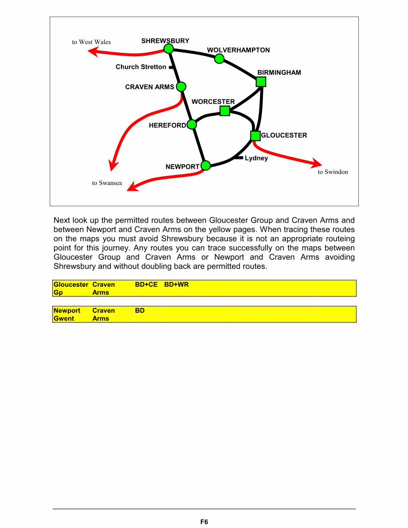
Next look up the permitted routes between Gloucester Group and Craven Arms andbetween Newport and Craven Arms on the yellow pages. When tracing these routeson the maps you must avoid Shrewsbury because it is not an appropriate routeingpoint for this journey. Any routes you can trace successfully on the maps betweenGloucester Group and Craven Arms or Newport and Craven Arms avoidingShrewsbury and without doubling back are permitted routes.
GloucesterGp
CravenArms
BD+CE BD+WR
NewportGwent
CravenArms
BD
SHREWSBURYWOLVERHAMPTON
BIRMINGHAM
CRAVEN ARMS
HEREFORD
NEWPORT
WORCESTER
GLOUCESTER
Church Stretton
Lydney
to Swansea
to West Wales
to Swindon
F7
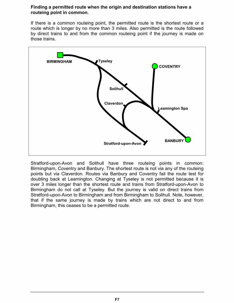
Finding a permitted route when the origin and destination stations have arouteing point in common.
If there is a common routeing point, the permitted route is the shortest route or aroute which is longer by no more than 3 miles. Also permitted is the route followedby direct trains to and from the common routeing point if the journey is made onthose trains.
Stratford-upon-Avon and Solihull have three routeing points in common:Birmingham, Coventry and Banbury. The shortest route is not via any of the routeingpoints but via Claverdon. Routes via Banbury and Coventry fail the route test fordoubling back at Leamington. Changing at Tyseley is not permitted because it isover 3 miles longer than the shortest route and trains from Stratford-upon-Avon toBirmingham do not call at Tyseley. But the journey is valid on direct trains fromStratford-upon-Avon to Birmingham and from Birmingham to Solihull. Note, however,that if the same journey is made by trains which are not direct to and fromBirmingham, this ceases to be a permitted route.
BIRMINGHAM
BANBURY
COVENTRYTyseley
Stratford-upon-Avon
Leamington Spa
Solihull
Claverdon
F8
Section C (the yellow pages) lists all journeys between pairs of routeing points andthe route codes for the permitted routes. Journeys are listed alphabetically by originand destination. As the permitted routes are the same in both directions of travel itmakes no difference which way round the journey is looked up. Sheffield toInverness has exactly the same permitted routes as Inverness to Sheffield and thesame is true of every other listed journey.
Sheffield Gp Inverness CE+ER CE+NE ER+PS LM+MM LM+MM+CS+PS LM+PSPS+ZZ
Inverness Sheffield Gp CE+ER CE+NE ER+PS LM+MM LM+MM+CS+PS LM+PSPS+ZZ
Route codes are strings of map names and plus signs. The simplest route code is asingle map. If your journey is Cambridge to Ipswich and the route code is CN thenthe whole journey can be traced on CN and no other map is allowed. Many journeyscannot be traced on a single map and need linking with other maps to allow acomplete tracing. Sheffield to Inverness has a route CE+ER which means use mapCE and then map ER. You may only trace journeys across maps at the points wherethey touch. CE and ER touch at Nottingham, Grimsby, Doncaster, Wakefield, Leeds,York, Hull, Goole and Selby so one of those locations must be in the journey.
Being able to trace the journey on a map or combination of maps does not mean agood train service follows the route of your choosing. Some will be better thanothers. To choose the best one for you, consult the National Rail Timetable.
Sheffield to Inverness has 7 different route codes. You may choose any route youcan find which does not double back, pass through a station forbidden by the faresroute, or avoid a station which the fares route demands.
Section D contains the maps referred to by route codes in Section C. Maps must not be used until the permitted routes have been identified in Section C.
If the route code is a single map, for example CS, then the only permitted routes arethose that can be traced between the origin and destination on that map alone.
If the route code has several maps, route tracing must observe the following rules:1. Tracing must start at one of the ends of the route code.2. All maps must be used.3. Maps must be used in strict sequence, first to last or last to first, according to the
end of the route code where reading began.4. Tracing may move from map to map only at a point where the two maps touch.5. Once route tracing has left a map it cannot return to it.6. Journeys may not double back except between stations which are members of a
routeing point group for interchange or unless an easement permits it.

F9
If there is a route “LONDON” as one of the permitted routes in the Routeing Guide,the range of permitted routes via London is discovered by the following method:1. Look up the permitted routes from the origin routeing point to London.2. Look up the permitted routes from London to the destination routeing point.3. Work out the range of permitted routes for the whole journey by combining any
route found in (1) with any route found in (2). All possible combinations arepermitted routes for the journey except those with a repeated map.
Example: Portsmouth–Derby has a route LONDON in the Routeing Guide. Section C(the yellow pages) has the following routes for the journey Portsmouth–London:
Portsmouth Gp London Gp CW+LB CW+SC CW+SC+LB CW+SD+LBMW+WX PD WW
and London–Derby:
London Gp Derby Gp CE+LM MM
Combining every route Portsmouth–London with every route London–Derby givesthe complete range of routes from which a permitted route may be picked:
CW+LB+LM+CE CW+LB+MMCW+SC+LM+CE CW+SC+MMCW+SC+LB+LM+CE CW+SC+LB+MMCW+SD+LB+LM+CE CW+SD+LB+MMMW+WX+LM+CE MW+WX+MMPD+LM+CE PD+MMWW+LM+CE WW+MM
If combining maps gives a route code with a repeated map, for exampleWX+LM+CS+LM, that would not be permitted because it breaks rule 5 of the routetracing procedure that a map once left cannot be returned to.
Routes created from the route LONDON in the yellow pages do not oblige you tochange in London. For example Oakham to Brighton has the route LONDON whichyields LB+MM. This allows the journey Oakham – Leicester – Bedford – Brighton,changing at Bedford and continuing via Thameslink to Brighton.
Sometimes origin and destination are on the same map, but the permitted routebetween them is not permitted by that map. For example, both Ashford Internationaland Lincoln appear on map CS, but the permitted route between AshfordInternational and Lincoln is not CS.
Section E lists easements which apply to routeings.An easement that extends permission is a positive easement. An easement which narrows permission is a negative easement.
F10
Easement types:
� Local easements, which allow a longer journey to the origin routeing point orfrom the destination routeing point, or which allow doubling back on this part ofthe journey. They may also forbid doubling back on this part of the journey.
� Routeing point easements, which allow a routeing point to be used which the
fares check would otherwise forbid. They may also disallow a routeing pointwhich the ordinary rules of the Routeing Guide would permit.
� Doubleback easements, which permit passing twice through the same station
on the portion of the journey between the origin and destination routeing points.
� Map easements, which allow journeys that routes permitted by maps do not
include.
� Fare route easements, which permit a journey which does not pass through the
station named in the fares route.
� Manual easements, which exist only as text in the computerised version of the
Routeing Guide� Circuitous route easements, which are applied to valid journeys to make them
invalid because they go by roundabout routes.
Map, double-back and fare route easements are always positive. Circuitous route easements are always negative. Other kinds of easements can be positive or negative.
When you have chosen your journey, look to see if an easement applies to it.
Journeys between the stations shown on the ticket by direct trains; or by the shortest route which can be used by scheduled passenger services (including change of trains); are always following a permitted route. Journeys following a route given by the Routeing Guide are following a permitted route.
A journey not obeying these rules is not taking a permitted route unless a positive easement allows it.
A journey which follows a route otherwise permitted by the Routeing Guide may be forbidden by a negative easement.
F11
JOURNEY EXAMPLES (not current Routeing Guide data)
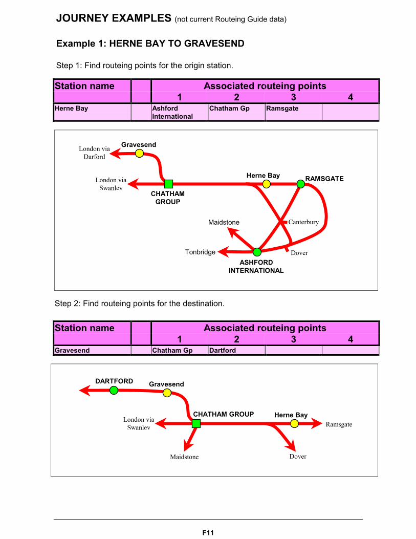
Example 1: HERNE BAY TO GRAVESEND
Step 1: Find routeing points for the origin station.
Station name Associated routeing points1 2 3 4
Herne Bay AshfordInternational
Chatham Gp Ramsgate
Step 2: Find routeing points for the destination.
Station name Associated routeing points1 2 3 4
Gravesend Chatham Gp Dartford
Gravesend
CHATHAMGROUP
Herne Bay
ASHFORDINTERNATIONAL
RAMSGATE
London viaDarford
London viaSwanley
Maidstone
Tonbridge Dover
Canterbury
Maidstone
Gravesend
CHATHAM GROUP Herne BayLondon viaSwanley
DARTFORD
Ramsgate
Dover
F12
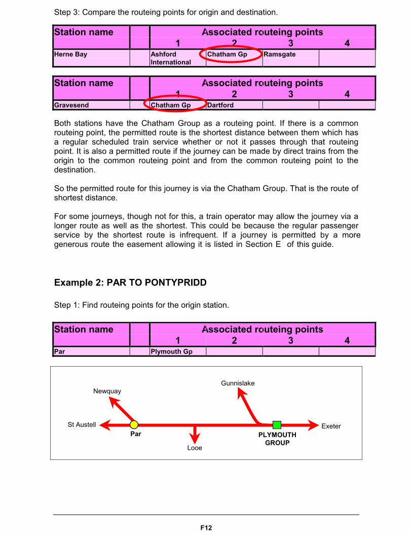
Step 3: Compare the routeing points for origin and destination.
Station name Associated routeing points1 2 3 4
Herne Bay AshfordInternational
Chatham Gp Ramsgate
Station name Associated routeing points1 2 3 4
Gravesend Chatham Gp Dartford
Both stations have the Chatham Group as a routeing point. If there is a commonrouteing point, the permitted route is the shortest distance between them which hasa regular scheduled train service whether or not it passes through that routeingpoint. It is also a permitted route if the journey can be made by direct trains from theorigin to the common routeing point and from the common routeing point to thedestination.
So the permitted route for this journey is via the Chatham Group. That is the route ofshortest distance.
For some journeys, though not for this, a train operator may allow the journey via a longer route as well as the shortest. This could be because the regular passenger service by the shortest route is infrequent. If a journey is permitted by a more generous route the easement allowing it is listed in Section E of this guide.
Example 2: PAR TO PONTYPRIDD
Step 1: Find routeing points for the origin station.
Station name Associated routeing points1 2 3 4
Par Plymouth Gp
ExeterPLYMOUTH
GROUP
Newquay
St Austell
Looe
Gunnislake
Par
F13
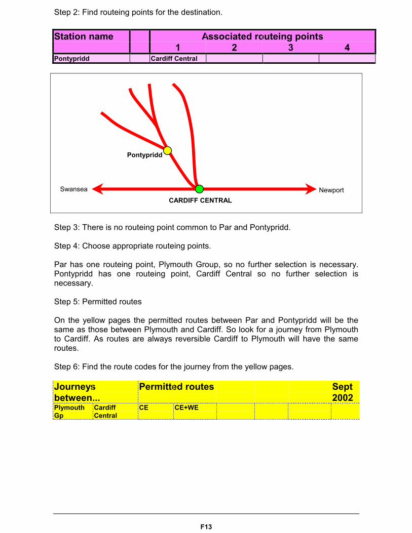
Step 2: Find routeing points for the destination.
Station name Associated routeing points1 2 3 4
Pontypridd Cardiff Central
Step 3: There is no routeing point common to Par and Pontypridd.
Step 4: Choose appropriate routeing points.
Par has one routeing point, Plymouth Group, so no further selection is necessary.Pontypridd has one routeing point, Cardiff Central so no further selection isnecessary.
Step 5: Permitted routes
On the yellow pages the permitted routes between Par and Pontypridd will be thesame as those between Plymouth and Cardiff. So look for a journey from Plymouthto Cardiff. As routes are always reversible Cardiff to Plymouth will have the sameroutes.
Step 6: Find the route codes for the journey from the yellow pages.
Journeysbetween...
Permitted routes Sept2002
PlymouthGp
CardiffCentral
CE CE+WE
CARDIFF CENTRAL
Pontypridd
NewportSwansea
F14
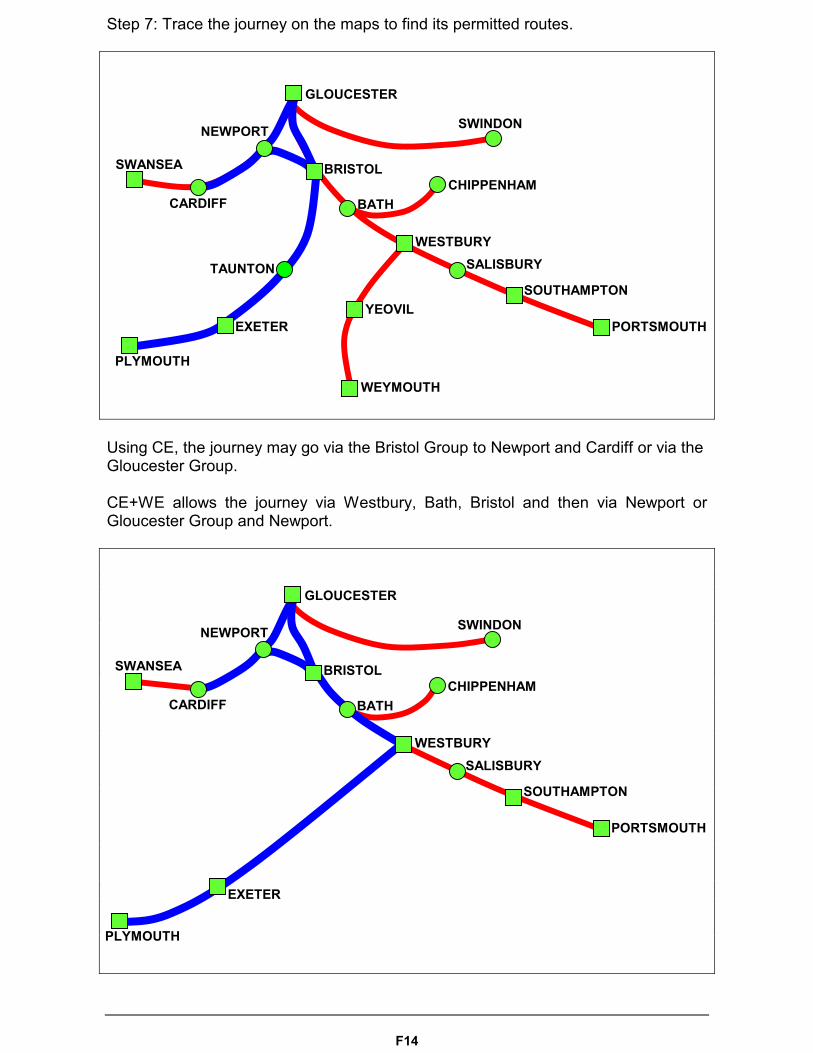
Step 7: Trace the journey on the maps to find its permitted routes.
Using CE, the journey may go via the Bristol Group to Newport and Cardiff or via theGloucester Group.
CE+WE allows the journey via Westbury, Bath, Bristol and then via Newport orGloucester Group and Newport.
BRISTOL
GLOUCESTER
SWANSEA
SALISBURY
NEWPORT
BATH
WESTBURY
SOUTHAMPTON
PORTSMOUTH
PLYMOUTH
EXETER
CARDIFF
SWINDON
CHIPPENHAM
GLOUCESTER
SWANSEA
SALISBURY
NEWPORT
BRISTOL
BATH
WESTBURY
SOUTHAMPTON
PORTSMOUTH
PLYMOUTH
EXETER
WEYMOUTH
YEOVIL
CARDIFF
SWINDON
CHIPPENHAM
TAUNTON
F15
When tracing the journey you may not double back (travel through the same stationtwice) unless an easement allows it. The permitted route is via the shortest distanceto the first routeing point over which a scheduled train service runs, then via thepermitted route, then via the shortest distance with a scheduled train service fromthe destination routeing point to the destination.
Step 8: Easements
No easements apply to this journey.

F16
Example 3: LONDON TO HUDDERSFIELD
Step 1: Find routeing points for the origin station.
Station name Associated routeing points1 2 3 4
LONDONBLACKFRIARS
London Group routeing point on mapsAS:CS:EA:EE:ER:GC:LB:LK:LM:MM:NK:PD:SC:TS:WA:WE:WR:WV:WW:WX:ZZ
LONDON BRIDGE London Group routeing point on mapsAS:CS:EA:EE:ER:GC:LB:LK:LM:MM:NK:PD:SC:TS:WA:WE:WR:WV:WW:WX:ZZ
LONDON CANNONSTREET
London Group routeing point on mapsAS:CS:EA:EE:ER:GC:LB:LK:LM:MM:NK:PD:SC:TS:WA:WE:WR:WV:WW:WX:ZZ
LONDON CHARINGCROSS
London Group routeing point on mapsAS:CS:EA:EE:ER:GC:LB:LK:LM:MM:NK:PD:SC:TS:WA:WE:WR:WV:WW:WX:ZZ
LONDON EUSTON London Group routeing point on mapsAS:CS:EA:EE:ER:GC:LB:LK:LM:MM:NK:PD:SC:TS:WA:WE:WR:WV:WW:WX:ZZ
LONDON FENCHURCHSTREET
London Group routeing point on mapsAS:CS:EA:EE:ER:GC:LB:LK:LM:MM:NK:PD:SC:TS:WA:WE:WR:WV:WW:WX:ZZ
London Fields Cambridge Highbury &Islington
London Gp Stratford London
LONDON KINGSCROSS
London Group routeing point on mapsAS:CS:EA:EE:ER:GC:LB:LK:LM:MM:NK:PD:SC:TS:WA:WE:WR:WV:WW:WX:ZZ
LONDON LIVERPOOLSTREET
London Group routeing point on mapsAS:CS:EA:EE:ER:GC:LB:LK:LM:MM:NK:PD:SC:TS:WA:WE:WR:WV:WW:WX:ZZ
LONDONMARYLEBONE
London Group routeing point on mapsAS:CS:EA:EE:ER:GC:LB:LK:LM:MM:NK:PD:SC:TS:WA:WE:WR:WV:WW:WX:ZZ
LONDONPADDINGTON
London Group routeing point on mapsAS:CS:EA:EE:ER:GC:LB:LK:LM:MM:NK:PD:SC:TS:WA:WE:WR:WV:WW:WX:ZZ
London RoadBrighton
Brighton Gp Lewes
London RoadGuildford
Dorking Gp Epsom Guildford Surbiton
LONDON ST PANCRAS London Group routeing point on mapsAS:CS:EA:EE:ER:GC:LB:LK:LM:MM:NK:PD:SC:TS:WA:WE:WR:WV:WW:WX:ZZ
LONDON VICTORIA London Group routeing point on mapsAS:CS:EA:EE:ER:GC:LB:LK:LM:MM:NK:PD:SC:TS:WA:WE:WR:WV:WW:WX:ZZ
LONDON WATERLOO London Group routeing point on mapsAS:CS:EA:EE:ER:GC:LB:LK:LM:MM:NK:PD:SC:TS:WA:WE:WR:WV:WW:WX:ZZ
LONDON WATERLOOEAST
London Group routeing point on mapsAS:CS:EA:EE:ER:GC:LB:LK:LM:MM:NK:PD:SC:TS:WA:WE:WR:WV:WW:WX:ZZ
F17
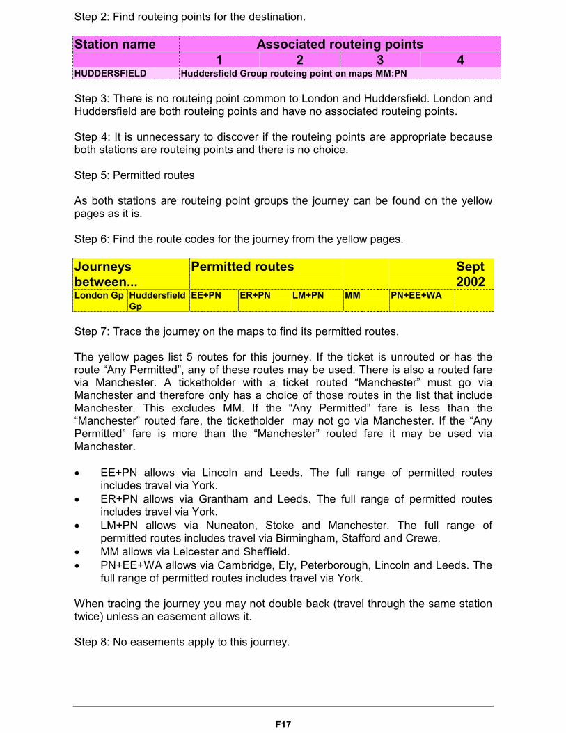
Step 2: Find routeing points for the destination.
Station name Associated routeing points1 2 3 4
HUDDERSFIELD Huddersfield Group routeing point on maps MM:PN
Step 3: There is no routeing point common to London and Huddersfield. London andHuddersfield are both routeing points and have no associated routeing points.
Step 4: It is unnecessary to discover if the routeing points are appropriate becauseboth stations are routeing points and there is no choice.
Step 5: Permitted routes
As both stations are routeing point groups the journey can be found on the yellowpages as it is.
Step 6: Find the route codes for the journey from the yellow pages.
Journeysbetween...
Permitted routes Sept2002
London Gp HuddersfieldGp
EE+PN ER+PN LM+PN MM PN+EE+WA
Step 7: Trace the journey on the maps to find its permitted routes.
The yellow pages list 5 routes for this journey. If the ticket is unrouted or has theroute “Any Permitted”, any of these routes may be used. There is also a routed farevia Manchester. A ticketholder with a ticket routed “Manchester” must go viaManchester and therefore only has a choice of those routes in the list that includeManchester. This excludes MM. If the “Any Permitted” fare is less than the“Manchester” routed fare, the ticketholder may not go via Manchester. If the “AnyPermitted” fare is more than the “Manchester” routed fare it may be used viaManchester.
� EE+PN allows via Lincoln and Leeds. The full range of permitted routesincludes travel via York.
� ER+PN allows via Grantham and Leeds. The full range of permitted routesincludes travel via York.
� LM+PN allows via Nuneaton, Stoke and Manchester. The full range ofpermitted routes includes travel via Birmingham, Stafford and Crewe.
� MM allows via Leicester and Sheffield.� PN+EE+WA allows via Cambridge, Ely, Peterborough, Lincoln and Leeds. The
full range of permitted routes includes travel via York.
When tracing the journey you may not double back (travel through the same stationtwice) unless an easement allows it.
Step 8: No easements apply to this journey.
F18
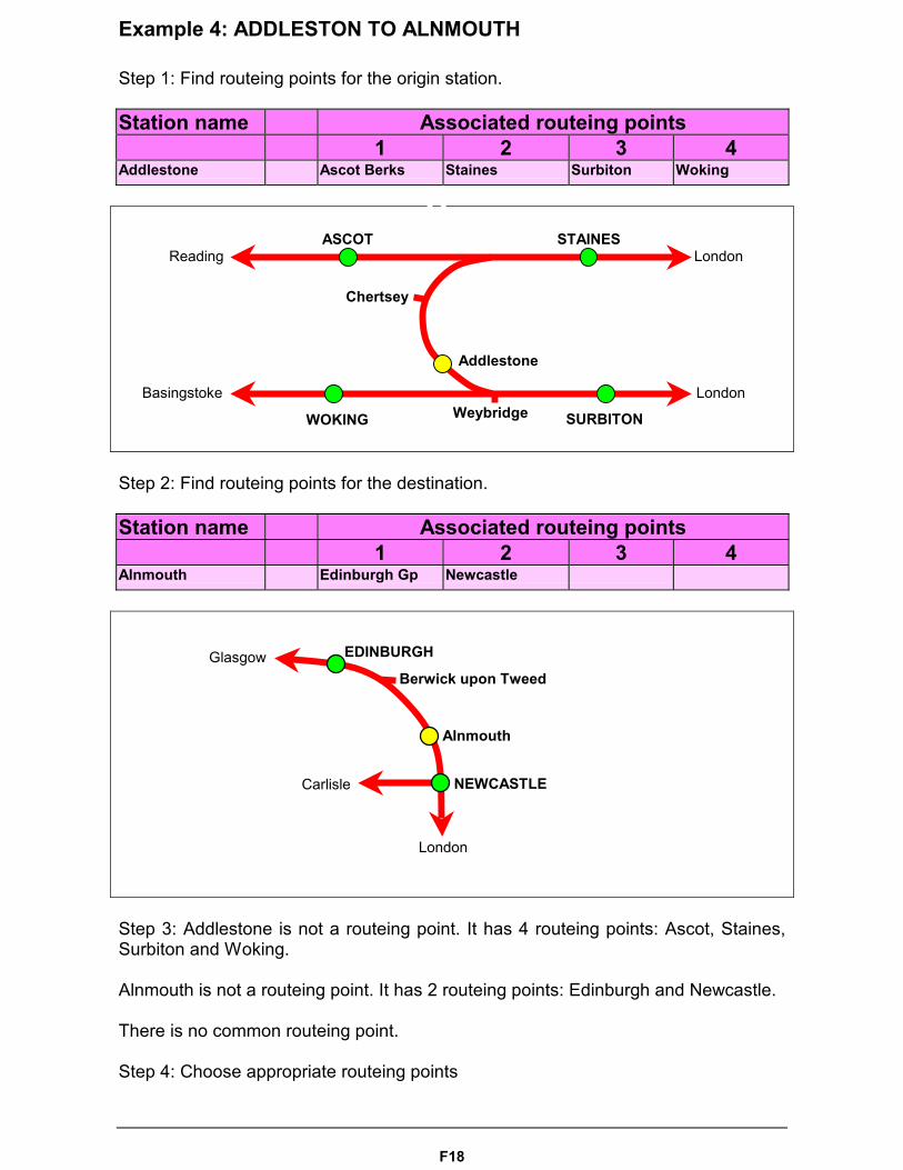
Example 4: ADDLESTON TO ALNMOUTH
Step 1: Find routeing points for the origin station.
Station name Associated routeing points1 2 3 4
Addlestone Ascot Berks Staines Surbiton Woking
Step 2: Find routeing points for the destination.
Station name Associated routeing points1 2 3 4
Alnmouth Edinburgh Gp Newcastle
Step 3: Addlestone is not a routeing point. It has 4 routeing points: Ascot, Staines,Surbiton and Woking.
Alnmouth is not a routeing point. It has 2 routeing points: Edinburgh and Newcastle.
There is no common routeing point.
Step 4: Choose appropriate routeing points
EDINBURGH
NEWCASTLE
Alnmouth
Berwick upon TweedGlasgow
Carlisle
London
London
London
Reading
Basingstoke
Addlestone
Chertsey
STAINES
SURBITONWOKING
ASCOT
Weybridge
F19
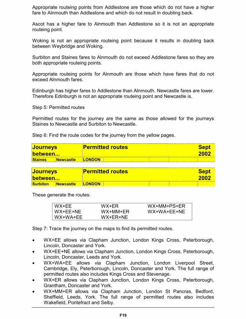
Appropriate routeing points from Addlestone are those which do not have a higherfare to Alnmouth than Addlestone and which do not result in doubling back.
Ascot has a higher fare to Alnmouth than Addlestone so it is not an appropriaterouteing point.
Woking is not an appropriate routeing point because it results in doubling backbetween Weybridge and Woking.
Surbiton and Staines fares to Alnmouth do not exceed Addlestone fares so they areboth appropriate routeing points.
Appropriate routeing points for Alnmouth are those which have fares that do notexceed Alnmouth fares.
Edinburgh has higher fares to Addlestone than Alnmouth. Newcastle fares are lower.Therefore Edinburgh is not an appropriate routeing point and Newcastle is.
Step 5: Permitted routes
Permitted routes for the journey are the same as those allowed for the journeysStaines to Newcastle and Surbiton to Newcastle.
Step 6: Find the route codes for the journey from the yellow pages.
Journeysbetween...
Permitted routes Sept2002
Staines Newcastle LONDON
Journeysbetween...
Permitted routes Sept2002
Surbiton Newcastle LONDON
These generate the routes:
WX+EE WX+ER WX+MM+PS+ERWX+EE+NE WX+MM+ER WX+WA+EE+NEWX+WA+EE WX+ER+NE
Step 7: Trace the journey on the maps to find its permitted routes.
� WX+EE allows via Clapham Junction, London Kings Cross, Peterborough,Lincoln, Doncaster and York.
� WX+EE+NE allows via Clapham Junction, London Kings Cross, Peterborough,Lincoln, Doncaster, Leeds and York.
� WX+WA+EE allows via Clapham Junction, London Liverpool Street,Cambridge, Ely, Peterborough, Lincoln, Doncaster and York. The full range ofpermitted routes also includes Kings Cross and Stevenage.
� WX+ER allows via Clapham Junction, London Kings Cross, Peterborough,Grantham, Doncaster and York.
� WX+MM+ER allows via Clapham Junction, London St Pancras, Bedford,Sheffield, Leeds, York. The full range of permitted routes also includesWakefield, Pontefract and Selby.
F20
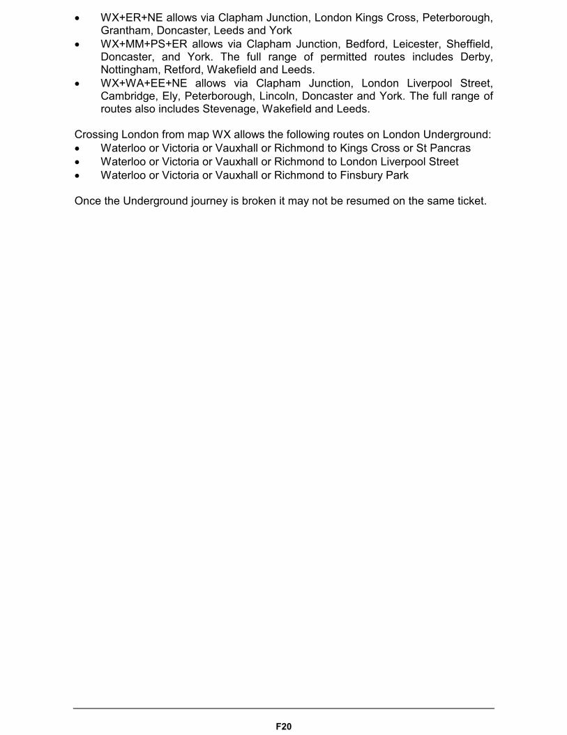
� WX+ER+NE allows via Clapham Junction, London Kings Cross, Peterborough,Grantham, Doncaster, Leeds and York
� WX+MM+PS+ER allows via Clapham Junction, Bedford, Leicester, Sheffield,Doncaster, and York. The full range of permitted routes includes Derby,Nottingham, Retford, Wakefield and Leeds.
� WX+WA+EE+NE allows via Clapham Junction, London Liverpool Street,Cambridge, Ely, Peterborough, Lincoln, Doncaster and York. The full range ofroutes also includes Stevenage, Wakefield and Leeds.
Crossing London from map WX allows the following routes on London Underground:� Waterloo or Victoria or Vauxhall or Richmond to Kings Cross or St Pancras� Waterloo or Victoria or Vauxhall or Richmond to London Liverpool Street� Waterloo or Victoria or Vauxhall or Richmond to Finsbury Park
Once the Underground journey is broken it may not be resumed on the same ticket.