The National Geodetic Survey toolkit: OPUS improvements ...
126
The National Geodetic Survey toolkit: OPUS improvements and plans Dr. Mark Schenewerk Edited & Presented by [email protected] National Geodetic Survey Silver Spring, MD SurvCon 2012, February 2, 2012 Bally's Park Place, Atlantic City, NJ
Transcript of The National Geodetic Survey toolkit: OPUS improvements ...
The National Geodetic Survey toolkit:
OPUS improvements and plans Dr. Mark Schenewerk
Edited & Presented by
[email protected] National Geodetic Survey
Silver Spring, MD
SurvCon 2012, February 2, 2012
Bally's Park Place, Atlantic City, NJ
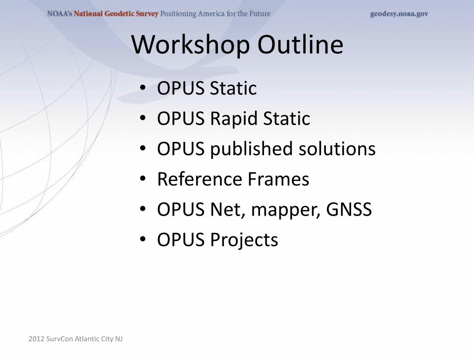
Workshop Outline
• OPUS Static
• OPUS Rapid Static
• OPUS published solutions
• Reference Frames
• OPUS Net, mapper, GNSS
• OPUS Projects
2012 SurvCon Atlantic City NJ
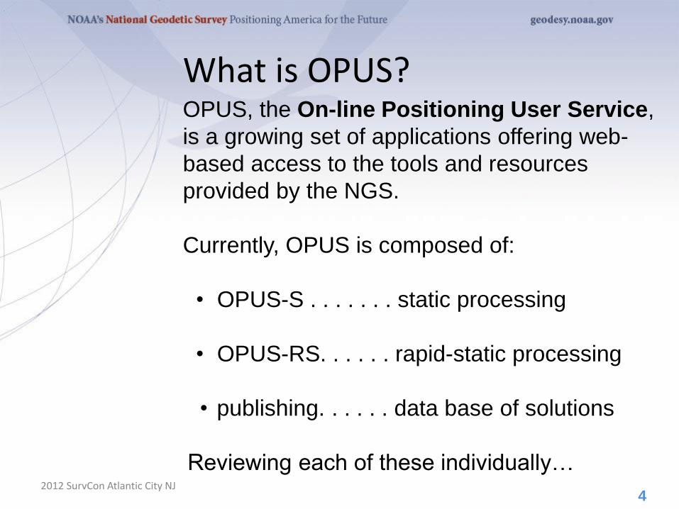
What is OPUS?
2012 SurvCon Atlantic City NJ
OPUS, the On-line Positioning User Service,
is a growing set of applications offering web-
based access to the tools and resources
provided by the NGS.
Currently, OPUS is composed of:
• OPUS-S . . . . . . . static processing
• OPUS-RS. . . . . . rapid-static processing
• publishing. . . . . . data base of solutions
Reviewing each of these individually…
4
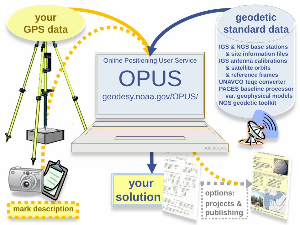
options:
projects &
publishing mark description
your
solution
Online Positioning User Service
OPUS geodesy.noaa.gov/OPUS/
JGE 2011v1
IGS & NGS base stations
& site information files
IGS antenna calibrations
& satellite orbits
& reference frames
UNAVCO teqc converter
PAGES baseline processor
var. geophysical models
NGS geodetic toolkit
your
GPS data
geodetic
standard data

A Little OPUS-S History
2012 SurvCon Atlantic City NJ
In the late 1990’s, a growing number of
organizations were making their Continuously
Operating Reference Station (CORS) data
publically available with a short latency.
Supporting products such as precise
ephemerides were improving and also
becoming available with a short latency.
Many organizations recognized that the time
seemed ripe for some sort of on-line,
processing service.
9
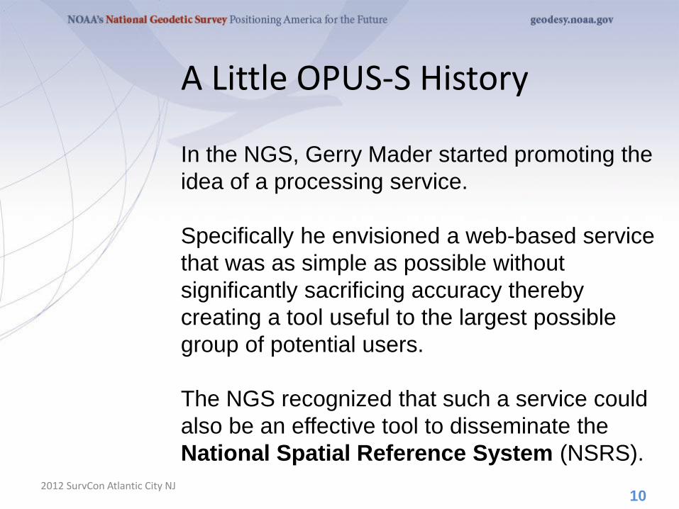
A Little OPUS-S History
2012 SurvCon Atlantic City NJ
In the NGS, Gerry Mader started promoting the
idea of a processing service.
Specifically he envisioned a web-based service
that was as simple as possible without
significantly sacrificing accuracy thereby
creating a tool useful to the largest possible
group of potential users.
The NGS recognized that such a service could
also be an effective tool to disseminate the
National Spatial Reference System (NSRS).
10
A Little OPUS-S History
2012 SurvCon Atlantic City NJ
Mader and Weston (NGS) cloistered
themselves and, with the help others too
numerous to be mentioned here, created
OPUS, now called OPUS-S, essentially as it
exists today.
After an extended trial period, OPUS was
formally made available to the public in 2002.
11
The OPUS-S Interface
2012 SurvCon Atlantic City NJ
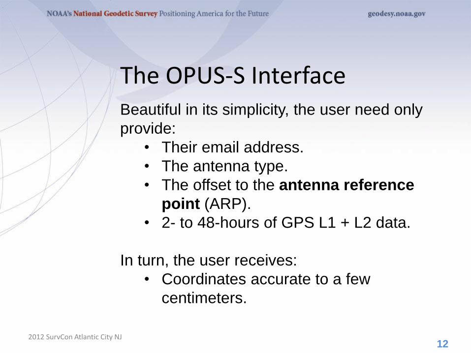
Beautiful in its simplicity, the user need only
provide:
• Their email address.
• The antenna type.
• The offset to the antenna reference
point (ARP).
• 2- to 48-hours of GPS L1 + L2 data.
In turn, the user receives:
• Coordinates accurate to a few
centimeters.
12
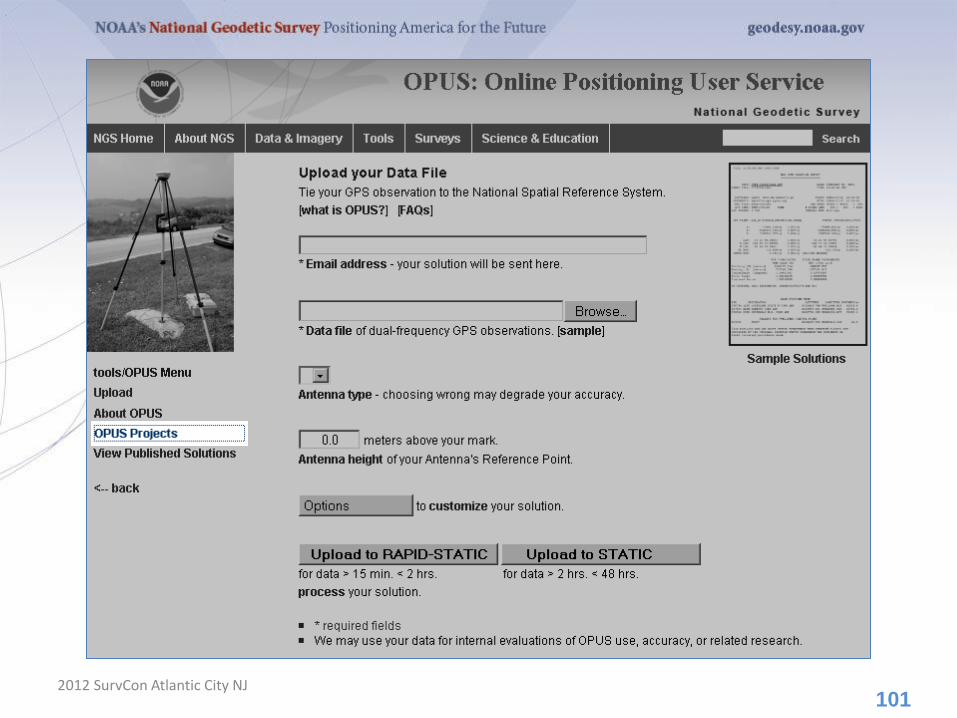
The OPUS-S Interface
2012 SurvCon Atlantic City NJ 13
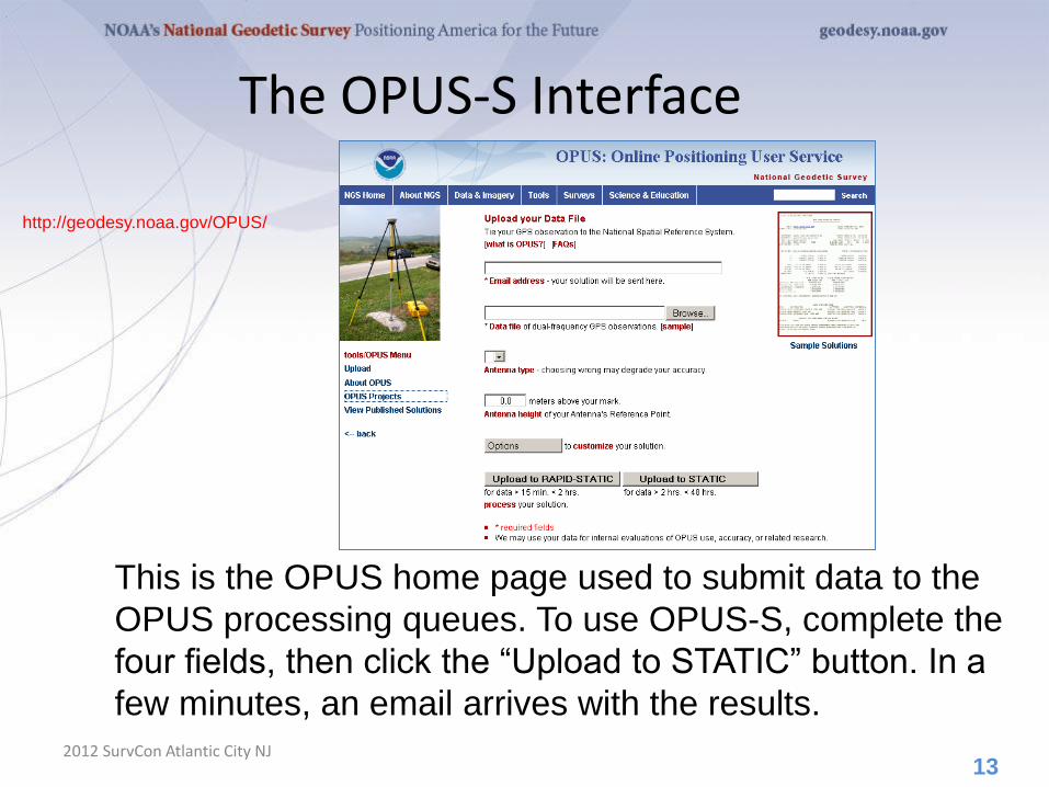
http://geodesy.noaa.gov/OPUS/
This is the OPUS home page used to submit data to the
OPUS processing queues. To use OPUS-S, complete the
four fields, then click the “Upload to STATIC” button. In a
few minutes, an email arrives with the results.
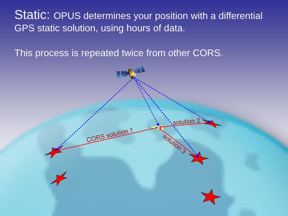
Static: OPUS determines your position with a differential
GPS static solution, using hours of data.
This process is repeated twice from other CORS.
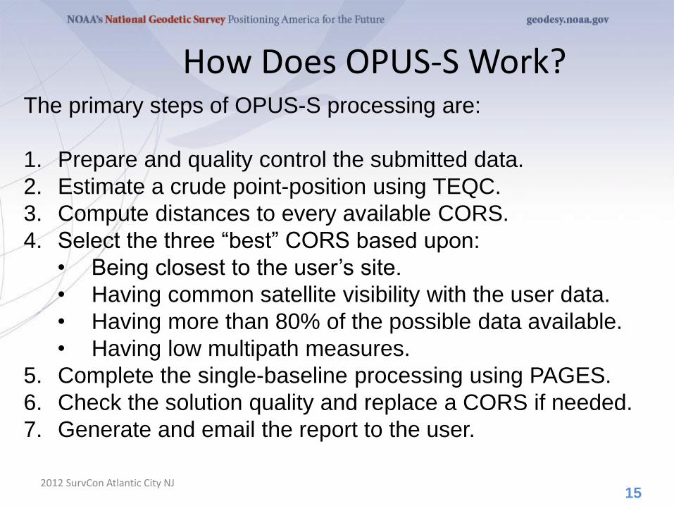
How Does OPUS-S Work?
2012 SurvCon Atlantic City NJ
The primary steps of OPUS-S processing are:
1. Prepare and quality control the submitted data.
2. Estimate a crude point-position using TEQC.
3. Compute distances to every available CORS.
4. Select the three “best” CORS based upon:
• Being closest to the user’s site.
• Having common satellite visibility with the user data.
• Having more than 80% of the possible data available.
• Having low multipath measures.
5. Complete the single-baseline processing using PAGES.
6. Check the solution quality and replace a CORS if needed.
7. Generate and email the report to the user.
15
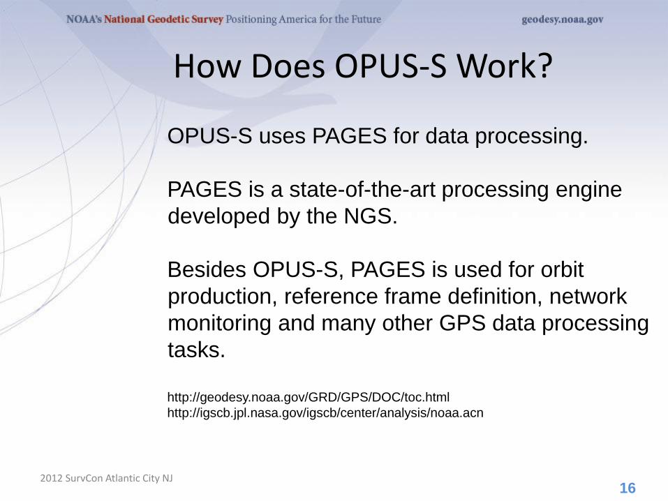
How Does OPUS-S Work?
2012 SurvCon Atlantic City NJ
OPUS-S uses PAGES for data processing.
PAGES is a state-of-the-art processing engine
developed by the NGS.
Besides OPUS-S, PAGES is used for orbit
production, reference frame definition, network
monitoring and many other GPS data processing
tasks.
http://geodesy.noaa.gov/GRD/GPS/DOC/toc.html
http://igscb.jpl.nasa.gov/igscb/center/analysis/noaa.acn
16
How Does OPUS-S Work?
2012 SurvCon Atlantic City NJ
OPUS-S modeling highlights:
• Satellite coordinates from the International GNSS Service
(IGS) precise ephemerides. http://igscb.jpl.nasa.gov/components/usage.html.
• CORS coordinates and hardware histories from the NGS
site information data base.
• Receiver antenna phase center offsets and variations from
the NGS absolute antenna model data base. http://geodesy.noaa.gov/ANTCAL/.
• International Earth Rotation Service (IERS) 2003 solid
Earth tide model. http://www.iers.org/nn_11216/IERS/EN/Publications/TechnicalNotes/tn32.html.
• Surface met from a climatological model. Boehm et al., “Short Note: A global model of pressure and temperature for geodetic applications”,
J. Geod., 2007.
17
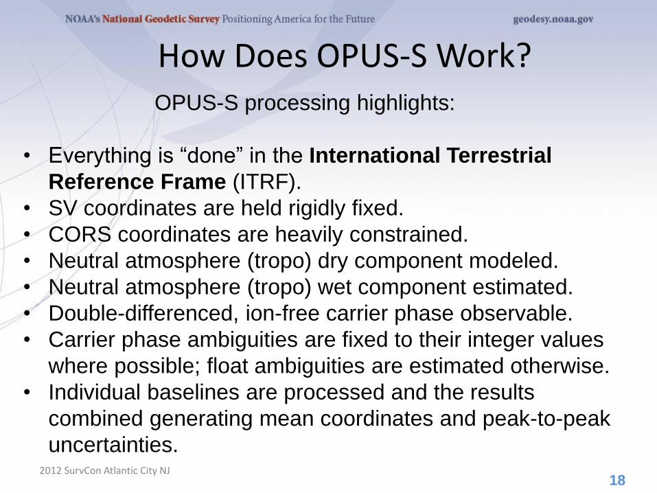
How Does OPUS-S Work?
2012 SurvCon Atlantic City NJ
OPUS-S processing highlights:
• Everything is “done” in the International Terrestrial
Reference Frame (ITRF).
• SV coordinates are held rigidly fixed.
• CORS coordinates are heavily constrained.
• Neutral atmosphere (tropo) dry component modeled.
• Neutral atmosphere (tropo) wet component estimated.
• Double-differenced, ion-free carrier phase observable.
• Carrier phase ambiguities are fixed to their integer values
where possible; float ambiguities are estimated otherwise.
• Individual baselines are processed and the results
combined generating mean coordinates and peak-to-peak
uncertainties.
18
How Does OPUS-S Work?
2012 SurvCon Atlantic City NJ
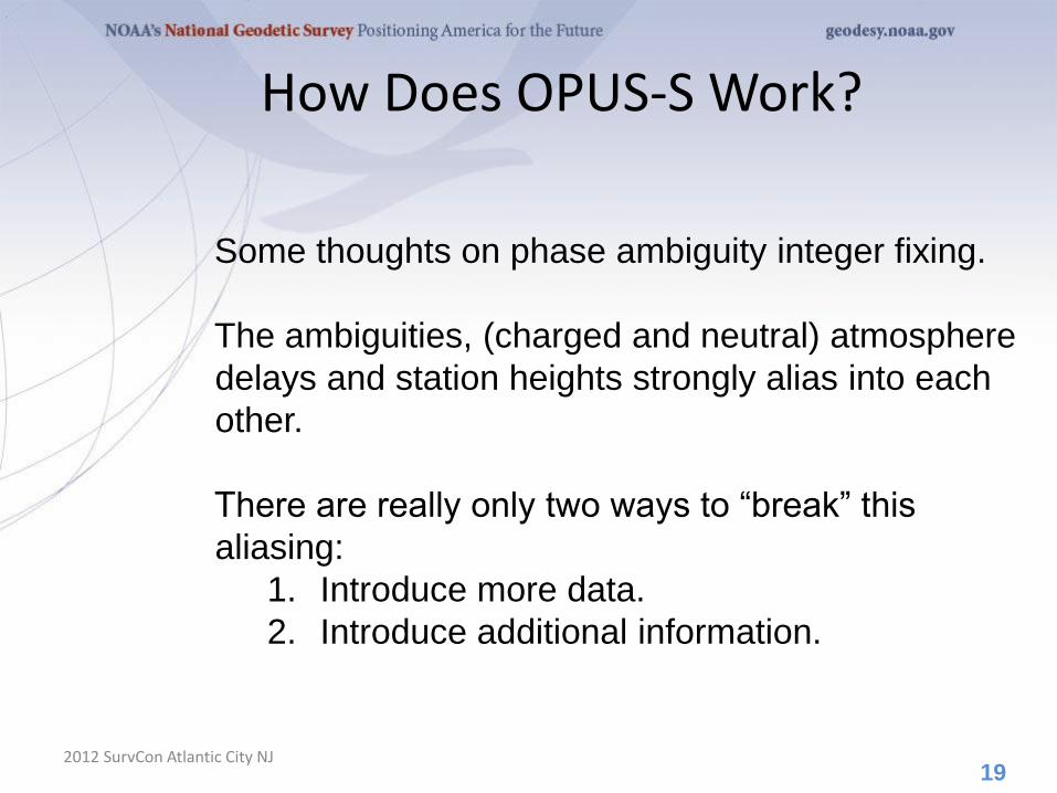
Some thoughts on phase ambiguity integer fixing.
The ambiguities, (charged and neutral) atmosphere
delays and station heights strongly alias into each
other.
There are really only two ways to “break” this
aliasing:
1. Introduce more data.
2. Introduce additional information.
19
How Does OPUS-S Work?
2012 SurvCon Atlantic City NJ
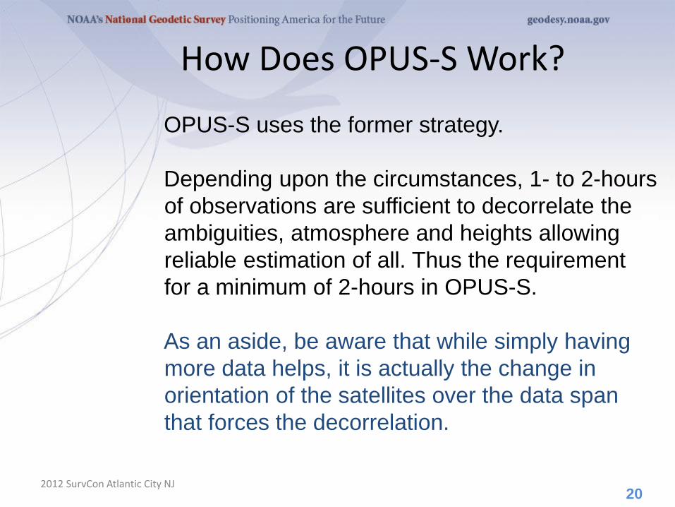
OPUS-S uses the former strategy.
Depending upon the circumstances, 1- to 2-hours
of observations are sufficient to decorrelate the
ambiguities, atmosphere and heights allowing
reliable estimation of all. Thus the requirement
for a minimum of 2-hours in OPUS-S.
As an aside, be aware that while simply having
more data helps, it is actually the change in
orientation of the satellites over the data span
that forces the decorrelation.
20
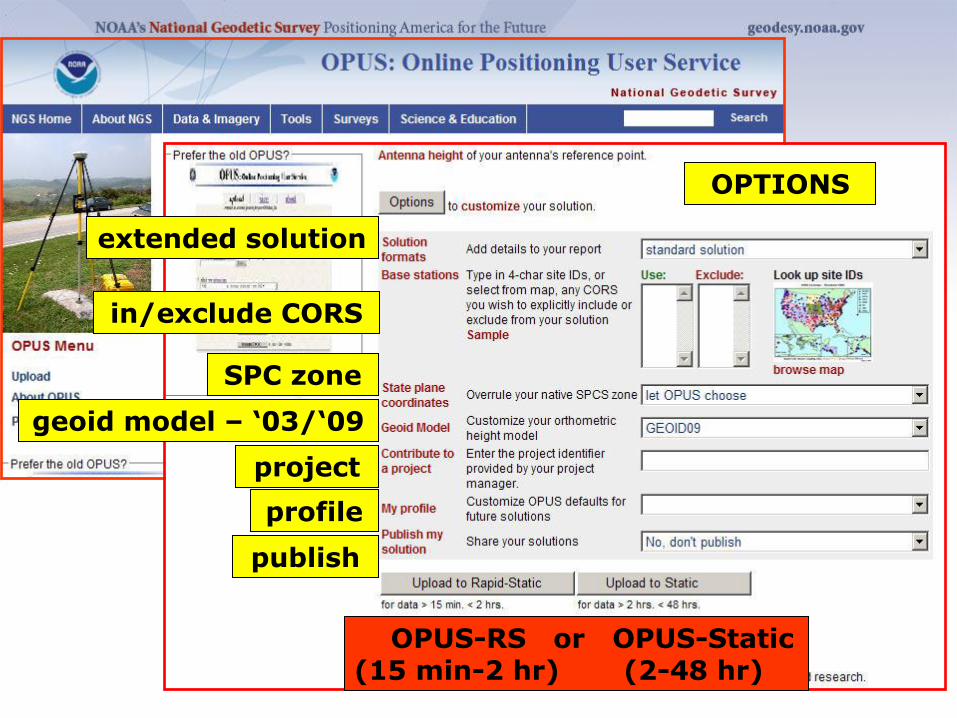
GPS file
antenna
antenna height
OPTIONS
in/exclude CORS
extended solution
SPC zone
geoid model – ‘03/‘09
project
profile
publish
OPUS-RS or OPUS-Static (15 min-2 hr) (2-48 hr)
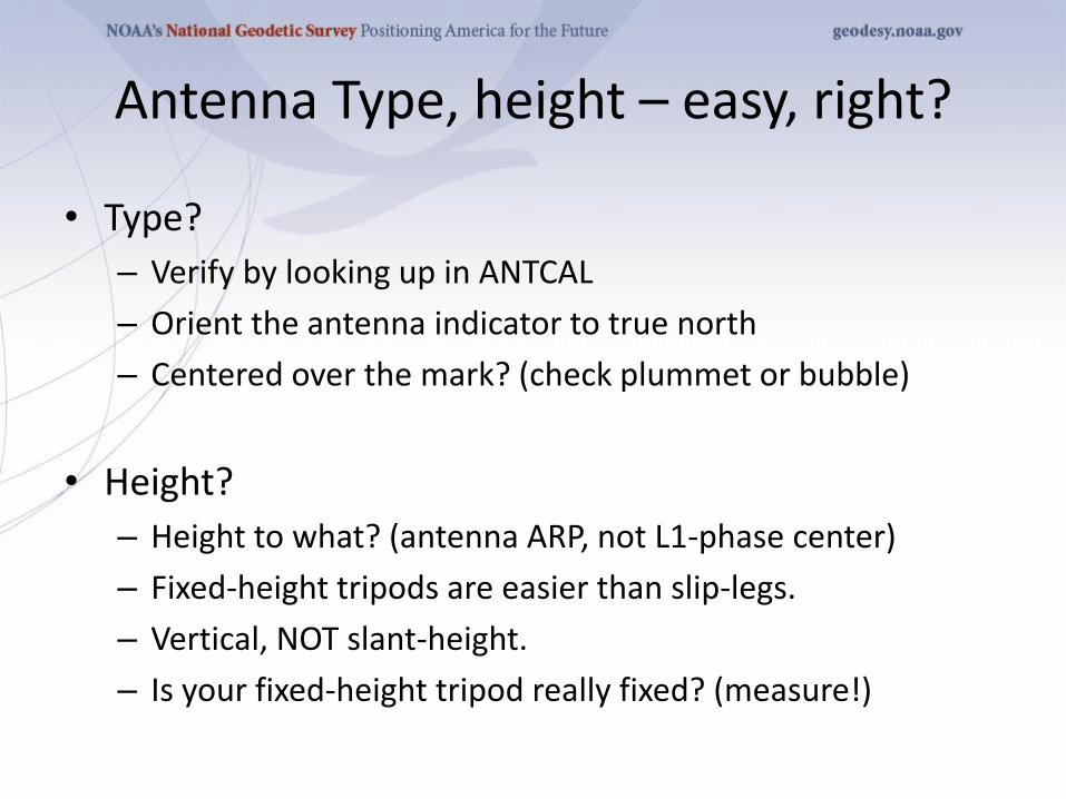
Antenna Type, height – easy, right?
• Type?
– Verify by looking up in ANTCAL
– Orient the antenna indicator to true north
– Centered over the mark? (check plummet or bubble)
• Height?
– Height to what? (antenna ARP, not L1-phase center)
– Fixed-height tripods are easier than slip-legs.
– Vertical, NOT slant-height.
– Is your fixed-height tripod really fixed? (measure!)
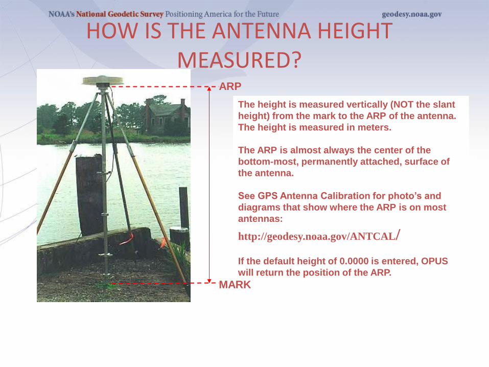
HOW IS THE ANTENNA HEIGHT MEASURED?
ARP
MARK
The height is measured vertically (NOT the slant
height) from the mark to the ARP of the antenna.
The height is measured in meters.
The ARP is almost always the center of the
bottom-most, permanently attached, surface of
the antenna.
See GPS Antenna Calibration for photo’s and
diagrams that show where the ARP is on most
antennas:
http://geodesy.noaa.gov/ANTCAL/
If the default height of 0.0000 is entered, OPUS
will return the position of the ARP.
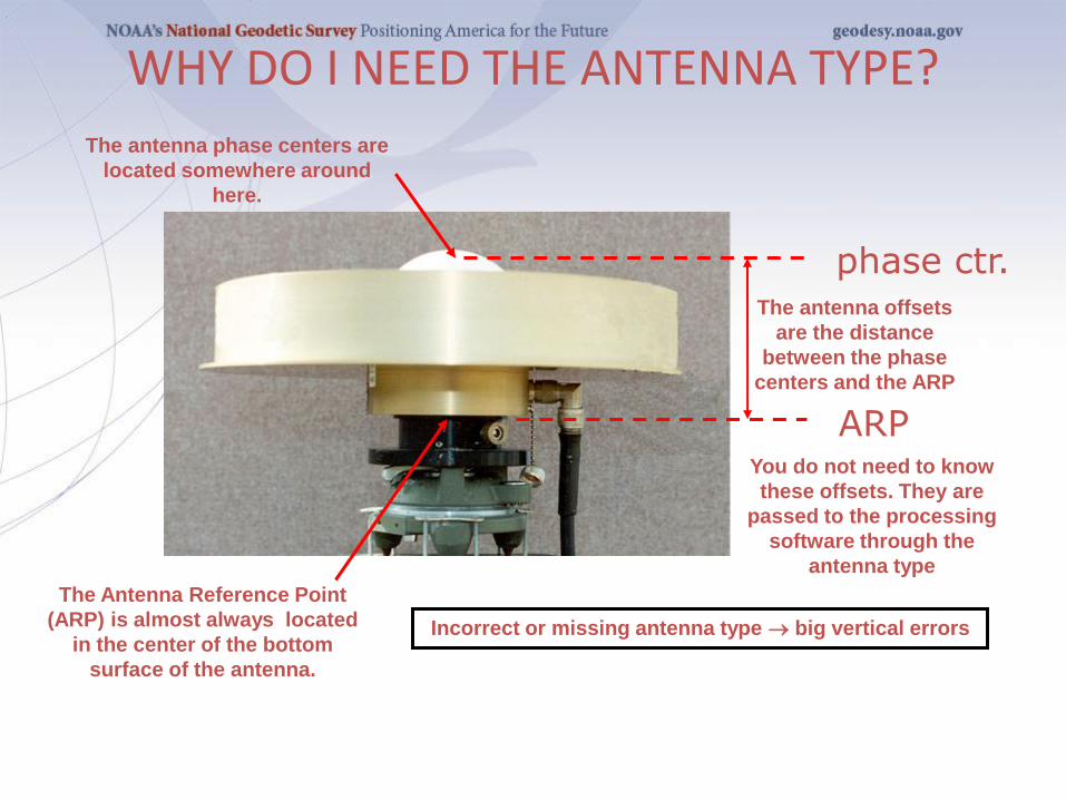
WHY DO I NEED THE ANTENNA TYPE?
The antenna phase centers are
located somewhere around
here.
The Antenna Reference Point
(ARP) is almost always located
in the center of the bottom
surface of the antenna.
The antenna offsets
are the distance
between the phase
centers and the ARP
You do not need to know
these offsets. They are
passed to the processing
software through the
antenna type
Incorrect or missing antenna type big vertical errors
ARP
phase ctr.
What else can go wrong?
• Site
– instability, multi-path
– mark ID (search database, check stamping)
• Weather
– wild, local troposphere issues?
– space weather: ionospheric issues?
• “Truth” (orbits, CORS, etc.)
– Rapid (next-day) orbits required for publishing
How Good Can I Do With OPUS-S?
2012 SurvCon Atlantic City NJ
OPUS-S reliably addresses the more historically
conventional requirements for GPS data
processing. It typically yields accuracies of:
1 – 2 cm horizontally
2 – 4 cm vertically
However, there is no guarantee that this stated
accuracy will result from any given data set.
Confirming the quality of the OPUS solution
remains the user’s responsibility. That’s the
“price” for automated processing.
26
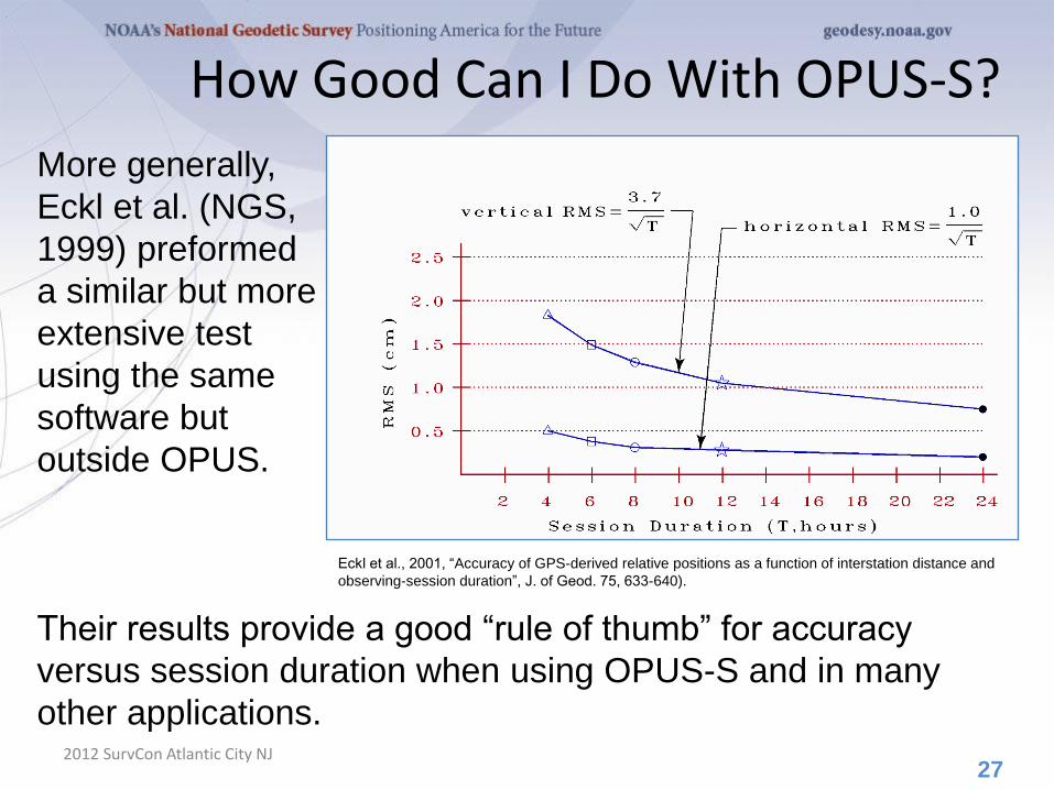
How Good Can I Do With OPUS-S?
2012 SurvCon Atlantic City NJ
More generally,
Eckl et al. (NGS,
1999) preformed
a similar but more
extensive test
using the same
software but
outside OPUS.
27
Eckl et al., 2001, “Accuracy of GPS-derived relative positions as a function of interstation distance and
observing-session duration”, J. of Geod. 75, 633-640).
Their results provide a good “rule of thumb” for accuracy
versus session duration when using OPUS-S and in many
other applications.
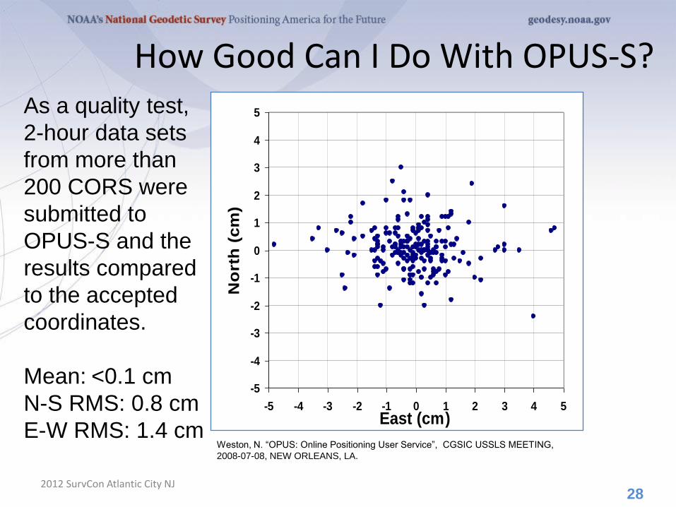
How Good Can I Do With OPUS-S?
2012 SurvCon Atlantic City NJ
As a quality test,
2-hour data sets
from more than
200 CORS were
submitted to
OPUS-S and the
results compared
to the accepted
coordinates.
Mean: <0.1 cm
N-S RMS: 0.8 cm
E-W RMS: 1.4 cm
28
-5
-4
-3
-2
-1
0
1
2
3
4
5
-5 -4 -3 -2 -1 0 1 2 3 4 5East (cm)
No
rth
(cm
)
Weston, N. “OPUS: Online Positioning User Service”, CGSIC USSLS MEETING,
2008-07-08, NEW ORLEANS, LA.
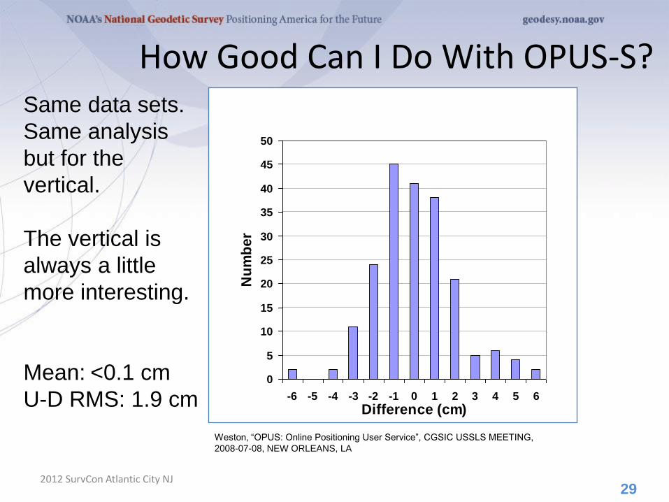
How Good Can I Do With OPUS-S?
2012 SurvCon Atlantic City NJ
Same data sets.
Same analysis
but for the
vertical.
The vertical is
always a little
more interesting.
Mean: <0.1 cm
U-D RMS: 1.9 cm
29
0
5
10
15
20
25
30
35
40
45
50
-6 -5 -4 -3 -2 -1 0 1 2 3 4 5 6
Difference (cm)
Nu
mb
er
Weston, “OPUS: Online Positioning User Service”, CGSIC USSLS MEETING,
2008-07-08, NEW ORLEANS, LA
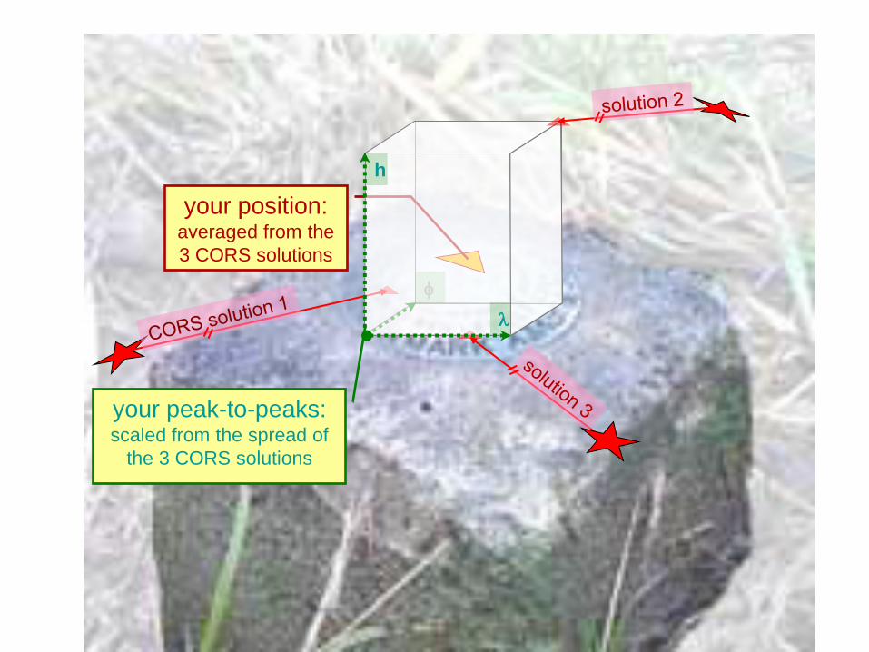
f
your position: averaged from the
3 CORS solutions
l
h
your peak-to-peaks: scaled from the spread of
the 3 CORS solutions
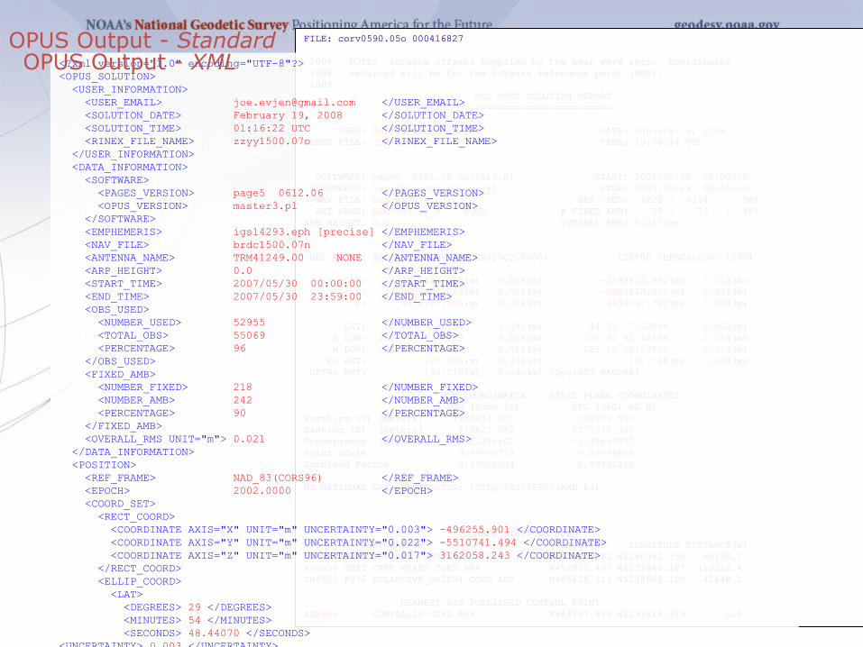
FILE: corv0590.05o 000416827
1008 NOTE: Antenna offsets supplied by the user were zero. Coordinates
1008 returned will be for the antenna reference point (ARP).
1008
NGS OPUS SOLUTION REPORT
========================
USER: [email protected] DATE: January 13, 2006
RINEX FILE: corv059f.05o TIME: 19:08:14 UTC
SOFTWARE: page5 0601.10 master3.pl START: 2005/02/28 05:00:00
EPHEMERIS: igs13121.eph [precise] STOP: 2005/02/28 06:59:30
NAV FILE: brdc0590.05n OBS USED: 4228 / 4314 : 98%
ANT NAME: ASH700936B_M NONE # FIXED AMB: 25 / 29 : 86%
ARP HEIGHT: 0.0 OVERALL RMS: 0.013(m)
REF FRAME: NAD_83(CORS96)(EPOCH:2002.0000) ITRF00 (EPOCH:2005.1596)
X: -2498423.165(m) 0.018(m) -2498423.872(m) 0.018(m)
Y: -3802822.048(m) 0.021(m) -3802820.836(m) 0.021(m)
Z: 4454737.695(m) 0.024(m) 4454737.792(m) 0.024(m)
LAT: 44 35 7.91054 0.002(m) 44 35 7.92698 0.002(m)
E LON: 236 41 43.48129 0.014(m) 236 41 43.42434 0.014(m)
W LON: 123 18 16.51871 0.014(m) 123 18 16.57566 0.014(m)
EL HGT: 107.485(m) 0.034(m) 107.108(m) 0.034(m)
ORTHO HGT: 130.010(m) 0.043(m) [Geoid03 NAVD88]
UTM COORDINATES STATE PLANE COORDINATES
UTM (Zone 10) SPC (3601 OR N)
Northing (Y) [meters] 4936954.907 105971.557
Easting (X) [meters] 475821.322 2277335.385
Convergence [degrees] -0.21381402 -1.98897497
Point Scale 0.99960719 0.99994603
Combined Factor 0.99959034 0.99992918
US NATIONAL GRID DESIGNATOR: 10TDQ7582136955(NAD 83)
BASE STATIONS USED
PID DESIGNATION LATITUDE LONGITUDE DISTANCE(m)
AH2489 NEWP NEWPORT CORS ARP N443506.072 W1240342.736 60138.7
AJ6959 CHZZ CAPE MEARS CORS ARP N452911.437 W1235841.187 113322.4
DH4503 P376 EOLARESVR_OR2004 CORS ARP N445628.313 W1230608.100 42648.2
NEAREST NGS PUBLISHED CONTROL POINT
AH2486 CORVALLIS CORS ARP N443507.910 W1231816.519 0.0
OPUS Output - Standard FILE: corv0590.05o 000416827
1008 NOTE: Antenna offsets supplied by the user were zero. Coordinates
1008 returned will be for the antenna reference point (ARP).
1008
NGS OPUS SOLUTION REPORT
========================
USER: [email protected] DATE: January 13, 2006
RINEX FILE: corv059f.05o TIME: 19:08:14 UTC
SOFTWARE: page5 0601.10 master3.pl START: 2005/02/28 05:00:00
EPHEMERIS: igs13121.eph [precise] STOP: 2005/02/28 06:59:30
NAV FILE: brdc0590.05n OBS USED: 4228 / 4314 : 98%
ANT NAME: ASH700936B_M NONE # FIXED AMB: 25 / 29 : 86%
ARP HEIGHT: 0.0 OVERALL RMS: 0.013(m)
REF FRAME: NAD_83(CORS96)(EPOCH:2002.0000) ITRF00 (EPOCH:2005.1596)
X: -2498423.165(m) 0.018(m) -2498423.872(m) 0.018(m)
Y: -3802822.048(m) 0.021(m) -3802820.836(m) 0.021(m)
Z: 4454737.695(m) 0.024(m) 4454737.792(m) 0.024(m)
LAT: 44 35 7.91054 0.002(m) 44 35 7.92698 0.002(m)
E LON: 236 41 43.48129 0.014(m) 236 41 43.42434 0.014(m)
W LON: 123 18 16.51871 0.014(m) 123 18 16.57566 0.014(m)
EL HGT: 107.485(m) 0.034(m) 107.108(m) 0.034(m)
ORTHO HGT: 130.010(m) 0.043(m) [Geoid03 NAVD88]
UTM COORDINATES STATE PLANE COORDINATES
UTM (Zone 10) SPC (3601 OR N)
Northing (Y) [meters] 4936954.907 105971.557
Easting (X) [meters] 475821.322 2277335.385
Convergence [degrees] -0.21381402 -1.98897497
Point Scale 0.99960719 0.99994603
Combined Factor 0.99959034 0.99992918
US NATIONAL GRID DESIGNATOR: 10TDQ7582136955(NAD 83)
BASE STATIONS USED
PID DESIGNATION LATITUDE LONGITUDE DISTANCE(m)
AH2489 NEWP NEWPORT CORS ARP N443506.072 W1240342.736 60138.7
AJ6959 CHZZ CAPE MEARS CORS ARP N452911.437 W1235841.187 113322.4
DH4503 P376 EOLARESVR_OR2004 CORS ARP N445628.313 W1230608.100 42648.2
NEAREST NGS PUBLISHED CONTROL POINT
AH2486 CORVALLIS CORS ARP N443507.910 W1231816.519 0.0
<?xml version="1.0" encoding="UTF-8"?>
<OPUS_SOLUTION>
<USER_INFORMATION>
<USER_EMAIL> [email protected] </USER_EMAIL>
<SOLUTION_DATE> February 19, 2008 </SOLUTION_DATE>
<SOLUTION_TIME> 01:16:22 UTC </SOLUTION_TIME>
<RINEX_FILE_NAME> zzyy1500.07o </RINEX_FILE_NAME>
</USER_INFORMATION>
<DATA_INFORMATION>
<SOFTWARE>
<PAGES_VERSION> page5 0612.06 </PAGES_VERSION>
<OPUS_VERSION> master3.pl </OPUS_VERSION>
</SOFTWARE>
<EMPHEMERIS> igs14293.eph [precise] </EMPHEMERIS>
<NAV_FILE> brdc1500.07n </NAV_FILE>
<ANTENNA_NAME> TRM41249.00 NONE </ANTENNA_NAME>
<ARP_HEIGHT> 0.0 </ARP_HEIGHT>
<START_TIME> 2007/05/30 00:00:00 </START_TIME>
<END_TIME> 2007/05/30 23:59:00 </END_TIME>
<OBS_USED>
<NUMBER_USED> 52955 </NUMBER_USED>
<TOTAL_OBS> 55069 </TOTAL_OBS>
<PERCENTAGE> 96 </PERCENTAGE>
</OBS_USED>
<FIXED_AMB>
<NUMBER_FIXED> 218 </NUMBER_FIXED>
<NUMBER_AMB> 242 </NUMBER_AMB>
<PERCENTAGE> 90 </PERCENTAGE>
</FIXED_AMB>
<OVERALL_RMS UNIT="m"> 0.021 </OVERALL_RMS>
</DATA_INFORMATION>
<POSITION>
<REF_FRAME> NAD_83(CORS96) </REF_FRAME>
<EPOCH> 2002.0000 </EPOCH>
<COORD_SET>
<RECT_COORD>
<COORDINATE AXIS="X" UNIT="m" UNCERTAINTY="0.003"> -496255.901 </COORDINATE>
<COORDINATE AXIS="Y" UNIT="m" UNCERTAINTY="0.022"> -5510741.494 </COORDINATE>
<COORDINATE AXIS="Z" UNIT="m" UNCERTAINTY="0.017"> 3162058.243 </COORDINATE>
</RECT_COORD>
<ELLIP_COORD>
<LAT>
<DEGREES> 29 </DEGREES>
<MINUTES> 54 </MINUTES>
<SECONDS> 48.44070 </SECONDS>
<UNCERTAINTY> 0.003 </UNCERTAINTY>
<UNCERTAINTY_UNIT>m </UNCERTAINTY_UNIT>
</LAT>
<EAST_LONG>
<DEGREES>264 </DEGREES>
<MINUTES>51</MINUTES>
<SECONDS>15.31122</SECONDS>
<UNCERTAINTY>0.002</UNCERTAINTY>
<UNCERTAINTY_UNIT>m</UNCERTAINTY_UNIT>
</EAST_LONG>
<EL_HEIGHT>
<VALUE>-7.199</VALUE>
<UNCERTAINTY>0.027</UNCERTAINTY>
<UNCERTAINTY_UNIT>m</UNCERTAINTY_UNIT>
</EL_HEIGHT>
</ELLIP_COORD>
</COORD_SET>
</POSITION>
<POSITION>
<REF_FRAME>ITRF00 (EPOCH:2007.4096)</REF_FRAME>
<EPOCH>2007.4096</EPOCH>
<COORD_SET>
<RECT_COORD>
<COORDINATE AXIS="X" UNIT="m" UNCERTAINTY="0.003">-496256.585</COORDINATE>
<COORDINATE AXIS="Y" UNIT="m" UNCERTAINTY="0.022">-5510740.027</COORDINATE>
<COORDINATE AXIS="Z" UNIT="m" UNCERTAINTY="0.017">3162058.057</COORDINATE>
</RECT_COORD>
<ELLIP_COORD>
<LAT>
<DEGREES>29</DEGREES>
<MINUTES>54</MINUTES>
<SECONDS>48.45813</SECONDS>
<UNCERTAINTY>0.003</UNCERTAINTY>
<UNCERTAINTY_UNIT>m</UNCERTAINTY_UNIT>
</LAT>
<EAST_LONG>
<DEGREES>264</DEGREES>
<MINUTES>51</MINUTES>
<SECONDS>15.28092</SECONDS>
<UNCERTAINTY>0.002</UNCERTAINTY>
<UNCERTAINTY_UNIT>m</UNCERTAINTY_UNIT>
</EAST_LONG>
<EL_HEIGHT>
<VALUE>-8.505</VALUE>
<UNCERTAINTY>0.027</UNCERTAINTY>
<UNCERTAINTY_UNIT>m</UNCERTAINTY_UNIT>
</EL_HEIGHT>
</ELLIP_COORD>
</COORD_SET>
</POSITION>
<ORTHO_HGT UNCERTAINTY="0.037" UNIT="m" SOURCE="[Geoid03 NAVD88]">20.154</ORTHO_HGT>
<PLANE_COORD_INFO>
<PLANE_COORD_SPEC TYPE="UTM" ZONE="15">
<NORTHING UNIT="m">3311130.625</NORTHING>
<EASTING UNIT="m">292843.826</EASTING>
<CONVERGENCE UNIT="deg">-1.07044705</CONVERGENCE>
<SCALE>1.00012949</SCALE>
<CF>1.00013062</CF>
</PLANE_COORD_SPEC>
<PLANE_COORD_SPEC TYPE="SPC" ZONE="4204(TXSC
)">
<NORTHING UNIT="m">4236668.327</NORTHING>
<EASTING UNIT="m">972105.452</EASTING>
<CONVERGENCE UNIT="deg">1.88824726</CONVERGENCE>
<SCALE>0.99991407</SCALE>
<CF>0.99991520</CF>
</PLANE_COORD_SPEC>
<USNG>15RTP9284411131(NAD 83)
</USNG>
</PLANE_COORD_INFO>
<BASE_STATION_USED>
<PID>DE5999</PID>
<STATION_ID>ADKS</STATION_ID>
<DESIGNATION>ADDICKS 1795 CORS ARP</DESIGNATION>
<LATITUDE>N294727.47185</LATITUDE>
<LONGITUDE>W0953511.04262</LONGITUDE>
<DISTANCE>44692.309</DISTANCE>
</BASE_STATION_USED>
<BASE_STATION_USED>
<PID>DJ8995</PID>
<STATION_ID>ROD1</STATION_ID>
<DESIGNATION>ROD1 CORS ARP</DESIGNATION>
<LATITUDE>N300420.45377</LATITUDE>
<LONGITUDE>W0953136.45801</LONGITUDE>
<DISTANCE>40769.489</DISTANCE>
</BASE_STATION_USED>
<BASE_STATION_USED>
<PID>DH3612</PID>
<STATION_ID>TXLI</STATION_ID>
<DESIGNATION>LIBERTY CORS ARP</DESIGNATION>
<LATITUDE>N300321.18092</LATITUDE>
<LONGITUDE>W0944615.67967</LONGITUDE>
<DISTANCE>39457.656</DISTANCE>
</BASE_STATION_USED>
<NGS_PUBLISHED_CONTROL_POINT>
<PID>AA9861</PID>
<DESIGNATION>LAKE HOUSTON 2050 CORS L1 PHS </DESIGNATION>
<LATITUDE>N295448.44005</LATITUDE>
<LONGITUDE>W0950844.68949</LONGITUDE>
<DISTANCE>0.000</DISTANCE>
</NGS_PUBLISHED_CONTROL_POINT>
<NOTE> This position and the above vector components were computed without any
knowledge by the National Geodetic Survey regarding the equiqment or
field operating procedure used. </NOTE>
</OPUS_SOLUTION>
OPUS Output - XML
Back To Our Quick Example
2012 SurvCon Atlantic City NJ
If you’re uncomfortable with your results (we’re
not, but speaking hypothetically), check your
data first.
• Your hardware manufacturer may provide
QC software.
• Use third-party software such as TEQC. Estes and Meertens, “TEQC: The Multi-Purpose Toolkit for GPS/GLONASS
Data”, 1999,
GPS Solutions, 3, 1, 42-49.
• Resubmit requesting the extended report.
If you’re still uncomfortable, consider checking
the CORS used in the OPUS processing. The
performance of the CORS is reflected in your
results.
32
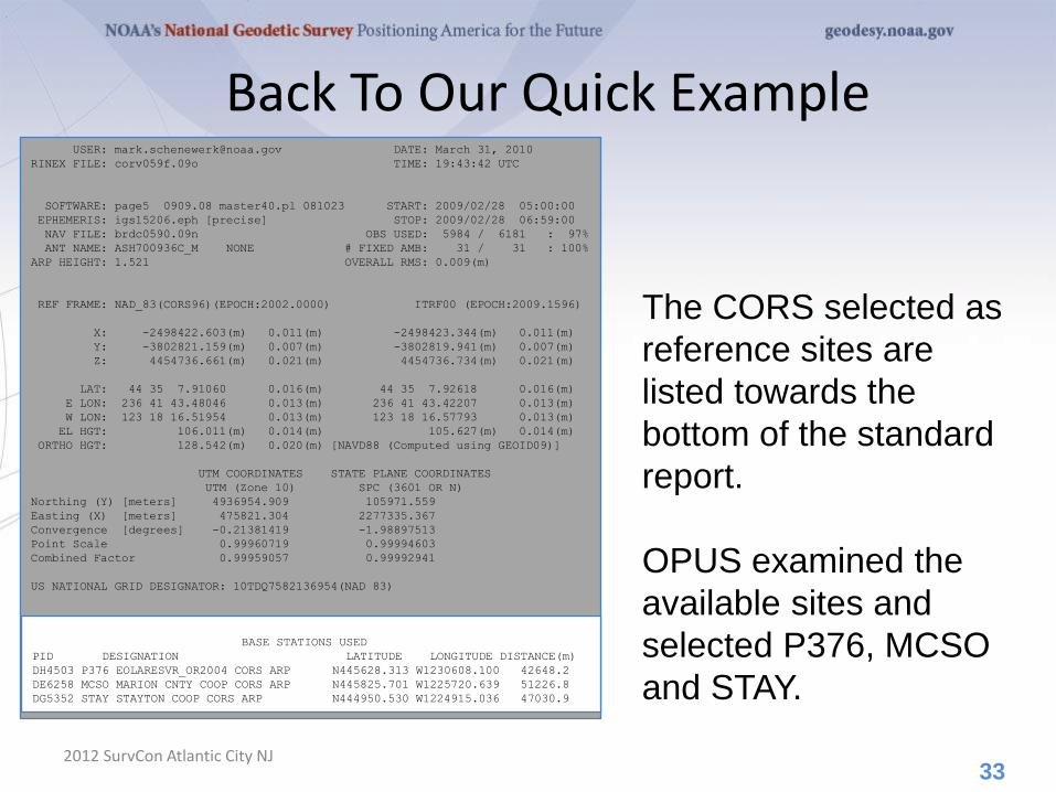
Back To Our Quick Example
2012 SurvCon Atlantic City NJ
The CORS selected as
reference sites are
listed towards the
bottom of the standard
report.
OPUS examined the
available sites and
selected P376, MCSO
and STAY.
33
USER: [email protected] DATE: March 31, 2010
RINEX FILE: corv059f.09o TIME: 19:43:42 UTC
SOFTWARE: page5 0909.08 master40.pl 081023 START: 2009/02/28 05:00:00
EPHEMERIS: igs15206.eph [precise] STOP: 2009/02/28 06:59:00
NAV FILE: brdc0590.09n OBS USED: 5984 / 6181 : 97%
ANT NAME: ASH700936C_M NONE # FIXED AMB: 31 / 31 : 100%
ARP HEIGHT: 1.521 OVERALL RMS: 0.009(m)
REF FRAME: NAD_83(CORS96)(EPOCH:2002.0000) ITRF00 (EPOCH:2009.1596)
X: -2498422.603(m) 0.011(m) -2498423.344(m) 0.011(m)
Y: -3802821.159(m) 0.007(m) -3802819.941(m) 0.007(m)
Z: 4454736.661(m) 0.021(m) 4454736.734(m) 0.021(m)
LAT: 44 35 7.91060 0.016(m) 44 35 7.92618 0.016(m)
E LON: 236 41 43.48046 0.013(m) 236 41 43.42207 0.013(m)
W LON: 123 18 16.51954 0.013(m) 123 18 16.57793 0.013(m)
EL HGT: 106.011(m) 0.014(m) 105.627(m) 0.014(m)
ORTHO HGT: 128.542(m) 0.020(m) [NAVD88 (Computed using GEOID09)]
UTM COORDINATES STATE PLANE COORDINATES
UTM (Zone 10) SPC (3601 OR N)
Northing (Y) [meters] 4936954.909 105971.559
Easting (X) [meters] 475821.304 2277335.367
Convergence [degrees] -0.21381419 -1.98897513
Point Scale 0.99960719 0.99994603
Combined Factor 0.99959057 0.99992941
US NATIONAL GRID DESIGNATOR: 10TDQ7582136954(NAD 83)
BASE STATIONS USED
PID DESIGNATION LATITUDE LONGITUDE DISTANCE(m)
DH4503 P376 EOLARESVR_OR2004 CORS ARP N445628.313 W1230608.100 42648.2
DE6258 MCSO MARION CNTY COOP CORS ARP N445825.701 W1225720.639 51226.8
DG5352 STAY STAYTON COOP CORS ARP N444950.530 W1224915.036 47030.9
BASE STATIONS USED
PID DESIGNATION LATITUDE LONGITUDE DISTANCE(m)
DH4503 P376 EOLARESVR_OR2004 CORS ARP N445628.313 W1230608.100 42648.2
DE6258 MCSO MARION CNTY COOP CORS ARP N445825.701 W1225720.639 51226.8
DG5352 STAY STAYTON COOP CORS ARP N444950.530 W1224915.036 47030.9
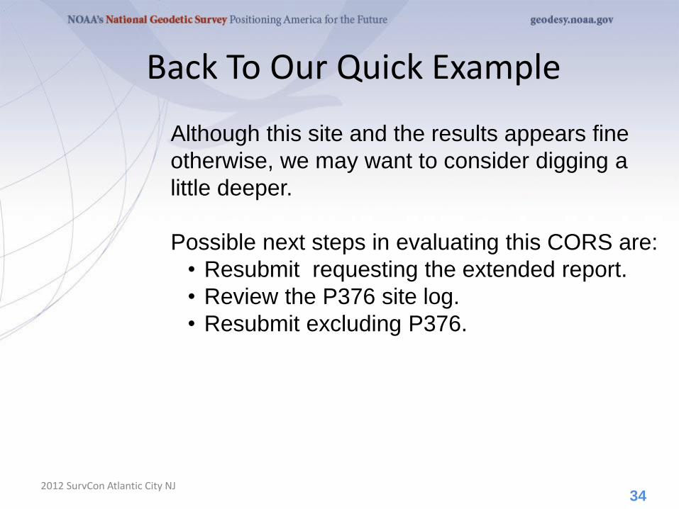
Back To Our Quick Example
2012 SurvCon Atlantic City NJ
Although this site and the results appears fine
otherwise, we may want to consider digging a
little deeper.
Possible next steps in evaluating this CORS are:
• Resubmit requesting the extended report.
• Review the P376 site log.
• Resubmit excluding P376.
34

OPUS-RS. . .rapid-static processing
2012 SurvCon Atlantic City NJ
• A Little OPUS-RS History.
• The OPUS-RS Interface.
• How Good Can I Do With OPUS-RS?
• A Quick Example (cont.).
• The Extended Report (cont.).
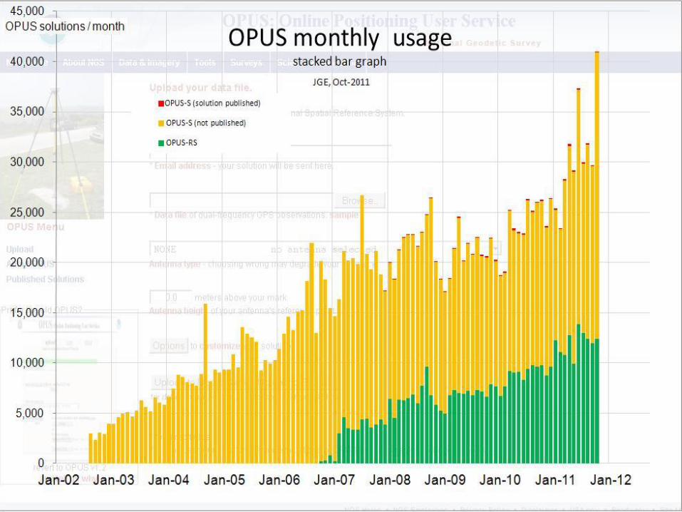
• How Does OPUS-RS Work?
• OPUS-S and OPUS-RS Uploads By Month.
35
A Little OPUS-RS History
2012 SurvCon Atlantic City NJ
Although successful, OPUS obviously does not
satisfy the needs of all users. Discussions with
the user community about future development
began almost immediately after OPUS was made
public.
These early discussions clearly indicated that the
most desired enhancement would be a tool
capable of producing a similar quality result from
a shorter data span.
36

A Little OPUS-RS History
2012 SurvCon Atlantic City NJ
Work by several groups demonstrated that
reliably producing results of similar quality to
OPUS from shorter data spans was possible.
Collaboration between the NGS and the Satellite
Positioning and Inertial Navigation (SPIN) group
at The Ohio State University enabled Schwarz
(DST) to implement a new processing engine
capable of generating those results.
In early 2007, OPUS-RS was made publically
available after its own trial period. To better
delineate uses, the original OPUS processing
stream was renamed OPUS-S.
37
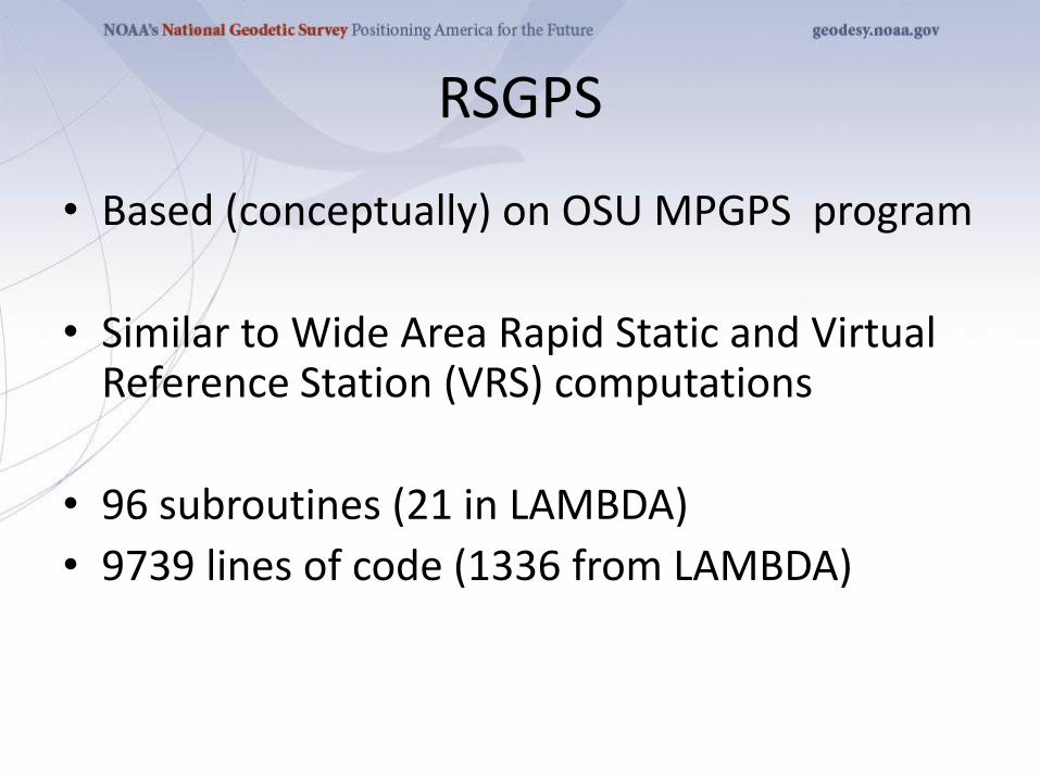
RSGPS
• Based (conceptually) on OSU MPGPS program
• Similar to Wide Area Rapid Static and Virtual Reference Station (VRS) computations
• 96 subroutines (21 in LAMBDA)
• 9739 lines of code (1336 from LAMBDA)
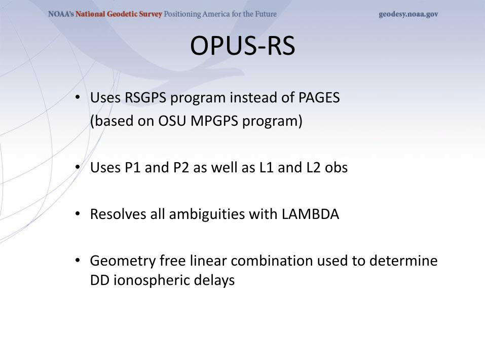
OPUS-RS
• Uses RSGPS program instead of PAGES
(based on OSU MPGPS program)
• Uses P1 and P2 as well as L1 and L2 obs
• Resolves all ambiguities with LAMBDA
• Geometry free linear combination used to determine DD ionospheric delays

Rapid-static: OPUS first creates an atmospheric delay
model from surrounding CORS data.
Your position is then quickly determined by differential GPS
static solution.
The OPUS-RS Interface
2012 SurvCon Atlantic City NJ
With OPUS-RS, the beautiful simplicity remained.
In fact the entry form is the same as for OPUS-S.
The user provides:
• Their email address.
• An antenna type.
• The vertical offset to the ARP.
• 15-minutes to 2-hours of GPS L1 + L2 data.
The user receives:
• Coordinates accurate to a few centimeters.
41

The same interface is used except one clicks the “Upload to
RAPID-STATIC” button instead.
The OPUS-RS Interface
2012 SurvCon Atlantic City NJ 42
http://geodesy.noaa.gov/OPUS/
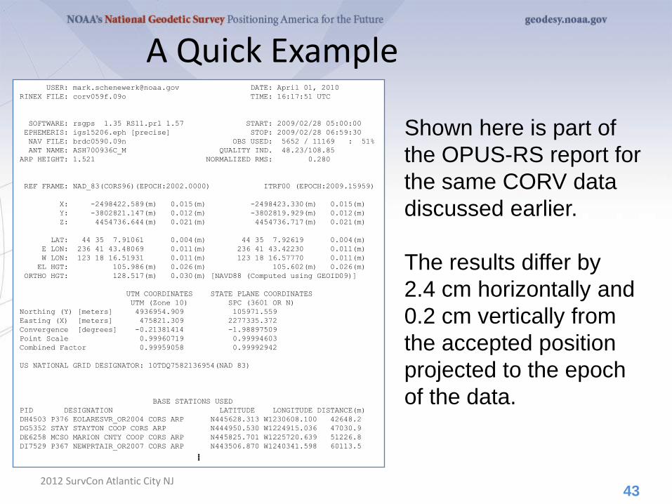
A Quick Example
2012 SurvCon Atlantic City NJ
Shown here is part of
the OPUS-RS report for
the same CORV data
discussed earlier.
The results differ by
2.4 cm horizontally and
0.2 cm vertically from
the accepted position
projected to the epoch
of the data.
43
USER: [email protected] DATE: April 01, 2010
RINEX FILE: corv059f.09o TIME: 16:17:51 UTC
SOFTWARE: rsgps 1.35 RS11.prl 1.57 START: 2009/02/28 05:00:00
EPHEMERIS: igs15206.eph [precise] STOP: 2009/02/28 06:59:30
NAV FILE: brdc0590.09n OBS USED: 5652 / 11169 : 51%
ANT NAME: ASH700936C_M QUALITY IND. 48.23/108.85
ARP HEIGHT: 1.521 NORMALIZED RMS: 0.280
REF FRAME: NAD_83(CORS96)(EPOCH:2002.0000) ITRF00 (EPOCH:2009.15959)
X: -2498422.589(m) 0.015(m) -2498423.330(m) 0.015(m)
Y: -3802821.147(m) 0.012(m) -3802819.929(m) 0.012(m)
Z: 4454736.644(m) 0.021(m) 4454736.717(m) 0.021(m)
LAT: 44 35 7.91061 0.004(m) 44 35 7.92619 0.004(m)
E LON: 236 41 43.48069 0.011(m) 236 41 43.42230 0.011(m)
W LON: 123 18 16.51931 0.011(m) 123 18 16.57770 0.011(m)
EL HGT: 105.986(m) 0.026(m) 105.602(m) 0.026(m)
ORTHO HGT: 128.517(m) 0.030(m) [NAVD88 (Computed using GEOID09)]
UTM COORDINATES STATE PLANE COORDINATES
UTM (Zone 10) SPC (3601 OR N)
Northing (Y) [meters] 4936954.909 105971.559
Easting (X) [meters] 475821.309 2277335.372
Convergence [degrees] -0.21381414 -1.98897509
Point Scale 0.99960719 0.99994603
Combined Factor 0.99959058 0.99992942
US NATIONAL GRID DESIGNATOR: 10TDQ7582136954(NAD 83)
BASE STATIONS USED
PID DESIGNATION LATITUDE LONGITUDE DISTANCE(m)
DH4503 P376 EOLARESVR_OR2004 CORS ARP N445628.313 W1230608.100 42648.2
DG5352 STAY STAYTON COOP CORS ARP N444950.530 W1224915.036 47030.9
DE6258 MCSO MARION CNTY COOP CORS ARP N445825.701 W1225720.639 51226.8
DI7529 P367 NEWPRTAIR_OR2007 CORS ARP N443506.870 W1240341.598 60113.5
⁞
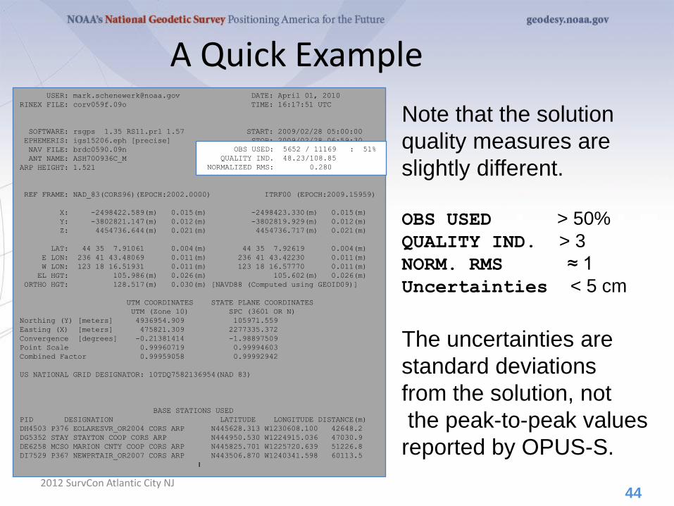
A Quick Example
2012 SurvCon Atlantic City NJ
Note that the solution
quality measures are
slightly different.
OBS USED > 50%
QUALITY IND. > 3
NORM. RMS ≈ 1
Uncertainties < 5 cm
The uncertainties are
standard deviations
from the solution, not
the peak-to-peak values
reported by OPUS-S.
44
USER: [email protected] DATE: April 01, 2010
RINEX FILE: corv059f.09o TIME: 16:17:51 UTC
SOFTWARE: rsgps 1.35 RS11.prl 1.57 START: 2009/02/28 05:00:00
EPHEMERIS: igs15206.eph [precise] STOP: 2009/02/28 06:59:30
NAV FILE: brdc0590.09n OBS USED: 5652 / 11169 : 51%
ANT NAME: ASH700936C_M QUALITY IND. 48.23/108.85
ARP HEIGHT: 1.521 NORMALIZED RMS: 0.280
REF FRAME: NAD_83(CORS96)(EPOCH:2002.0000) ITRF00 (EPOCH:2009.15959)
X: -2498422.589(m) 0.015(m) -2498423.330(m) 0.015(m)
Y: -3802821.147(m) 0.012(m) -3802819.929(m) 0.012(m)
Z: 4454736.644(m) 0.021(m) 4454736.717(m) 0.021(m)
LAT: 44 35 7.91061 0.004(m) 44 35 7.92619 0.004(m)
E LON: 236 41 43.48069 0.011(m) 236 41 43.42230 0.011(m)
W LON: 123 18 16.51931 0.011(m) 123 18 16.57770 0.011(m)
EL HGT: 105.986(m) 0.026(m) 105.602(m) 0.026(m)
ORTHO HGT: 128.517(m) 0.030(m) [NAVD88 (Computed using GEOID09)]
UTM COORDINATES STATE PLANE COORDINATES
UTM (Zone 10) SPC (3601 OR N)
Northing (Y) [meters] 4936954.909 105971.559
Easting (X) [meters] 475821.309 2277335.372
Convergence [degrees] -0.21381414 -1.98897509
Point Scale 0.99960719 0.99994603
Combined Factor 0.99959058 0.99992942
US NATIONAL GRID DESIGNATOR: 10TDQ7582136954(NAD 83)
BASE STATIONS USED
PID DESIGNATION LATITUDE LONGITUDE DISTANCE(m)
DH4503 P376 EOLARESVR_OR2004 CORS ARP N445628.313 W1230608.100 42648.2
DG5352 STAY STAYTON COOP CORS ARP N444950.530 W1224915.036 47030.9
DE6258 MCSO MARION CNTY COOP CORS ARP N445825.701 W1225720.639 51226.8
DI7529 P367 NEWPRTAIR_OR2007 CORS ARP N443506.870 W1240341.598 60113.5
⁞
OBS USED: 5652 / 11169 : 51%
QUALITY IND. 48.23/108.85
NORMALIZED RMS: 0.280
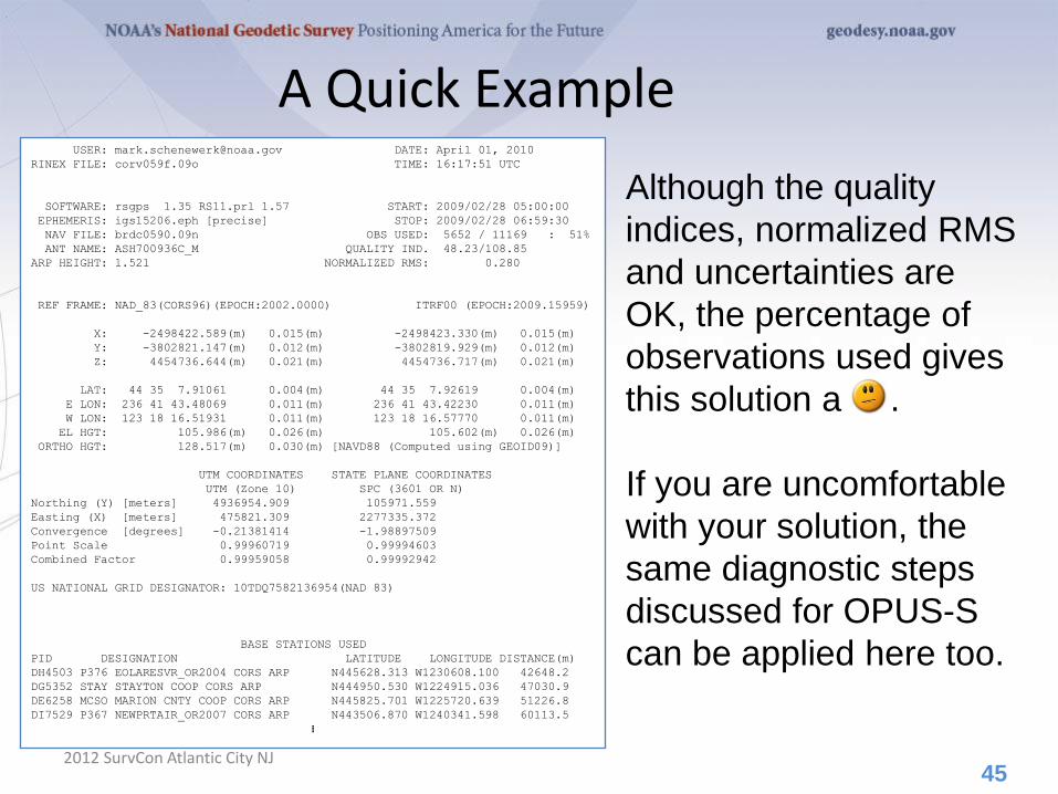
A Quick Example
2012 SurvCon Atlantic City NJ
Although the quality
indices, normalized RMS
and uncertainties are
OK, the percentage of
observations used gives
this solution a .
If you are uncomfortable
with your solution, the
same diagnostic steps
discussed for OPUS-S
can be applied here too.
45
USER: [email protected] DATE: April 01, 2010
RINEX FILE: corv059f.09o TIME: 16:17:51 UTC
SOFTWARE: rsgps 1.35 RS11.prl 1.57 START: 2009/02/28 05:00:00
EPHEMERIS: igs15206.eph [precise] STOP: 2009/02/28 06:59:30
NAV FILE: brdc0590.09n OBS USED: 5652 / 11169 : 51%
ANT NAME: ASH700936C_M QUALITY IND. 48.23/108.85
ARP HEIGHT: 1.521 NORMALIZED RMS: 0.280
REF FRAME: NAD_83(CORS96)(EPOCH:2002.0000) ITRF00 (EPOCH:2009.15959)
X: -2498422.589(m) 0.015(m) -2498423.330(m) 0.015(m)
Y: -3802821.147(m) 0.012(m) -3802819.929(m) 0.012(m)
Z: 4454736.644(m) 0.021(m) 4454736.717(m) 0.021(m)
LAT: 44 35 7.91061 0.004(m) 44 35 7.92619 0.004(m)
E LON: 236 41 43.48069 0.011(m) 236 41 43.42230 0.011(m)
W LON: 123 18 16.51931 0.011(m) 123 18 16.57770 0.011(m)
EL HGT: 105.986(m) 0.026(m) 105.602(m) 0.026(m)
ORTHO HGT: 128.517(m) 0.030(m) [NAVD88 (Computed using GEOID09)]
UTM COORDINATES STATE PLANE COORDINATES
UTM (Zone 10) SPC (3601 OR N)
Northing (Y) [meters] 4936954.909 105971.559
Easting (X) [meters] 475821.309 2277335.372
Convergence [degrees] -0.21381414 -1.98897509
Point Scale 0.99960719 0.99994603
Combined Factor 0.99959058 0.99992942
US NATIONAL GRID DESIGNATOR: 10TDQ7582136954(NAD 83)
BASE STATIONS USED
PID DESIGNATION LATITUDE LONGITUDE DISTANCE(m)
DH4503 P376 EOLARESVR_OR2004 CORS ARP N445628.313 W1230608.100 42648.2
DG5352 STAY STAYTON COOP CORS ARP N444950.530 W1224915.036 47030.9
DE6258 MCSO MARION CNTY COOP CORS ARP N445825.701 W1225720.639 51226.8
DI7529 P367 NEWPRTAIR_OR2007 CORS ARP N443506.870 W1240341.598 60113.5
⁞
The Extended Report
2012 SurvCon Atlantic City NJ
Of necessity, the OPUS-RS extended report is
larger than the corresponding OPUS-S solution.
Too large to be conveniently shown here. But
while seemingly intimidating, the OPUS-RS
extended report sections are basically the same
as those in the OPUS-S extended report.
Some additional sections include:
• A covariance matrix for the reference-station-
only solution.
• A correlation as well as a covariance matrix.
• Various Dilutions Of Precision (DOPs).
46
How Good Can I Do With OPUS-RS?
2012 SurvCon Atlantic City NJ
OPUS-RS can produce quality results from more challenging
“short” data sets, but it is slightly more restrictive in the data
sets allowed. Because of the restrictions, which will be
discussed later, the NGS recently made available the
“OPUS-RS Accuracy and Availability” tool (Choi, NGS).
Typical estimated and empirical accuracies within the
continental U.S. are comparable to OPUS-S.
Remember that the estimated accuracies suggested by this
tool are just that - estimates. Confirming the quality of the
OPUS solution remains the user’s responsibility.
47
How Good Can I Do With OPUS-RS?
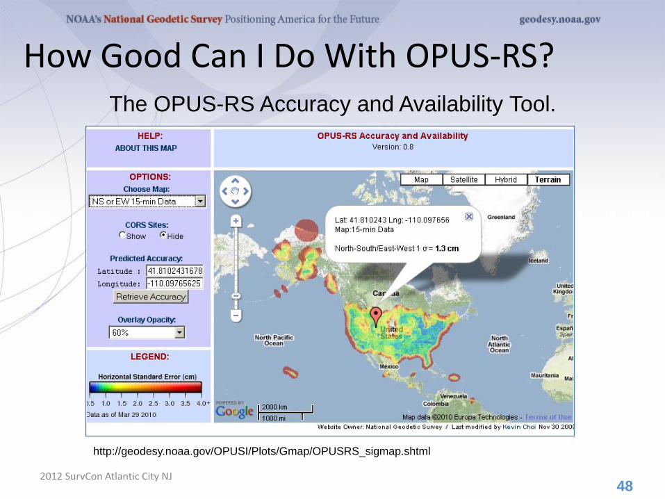
2012 SurvCon Atlantic City NJ
http://geodesy.noaa.gov/OPUSI/Plots/Gmap/OPUSRS_sigmap.shtml
48
The OPUS-RS Accuracy and Availability Tool.
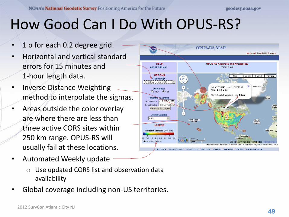
How Good Can I Do With OPUS-RS? • 1 σ for each 0.2 degree grid.
• Horizontal and vertical standard errors for 15 minutes and 1-hour length data.
• Inverse Distance Weighting method to interpolate the sigmas.
• Areas outside the color overlay are where there are less than three active CORS sites within 250 km range. OPUS-RS will usually fail at these locations.
• Automated Weekly update
o Use updated CORS list and observation data availability
• Global coverage including non-US territories.
2012 SurvCon Atlantic City NJ
49
How Does OPUS-RS Work?
2012 SurvCon Atlantic City NJ
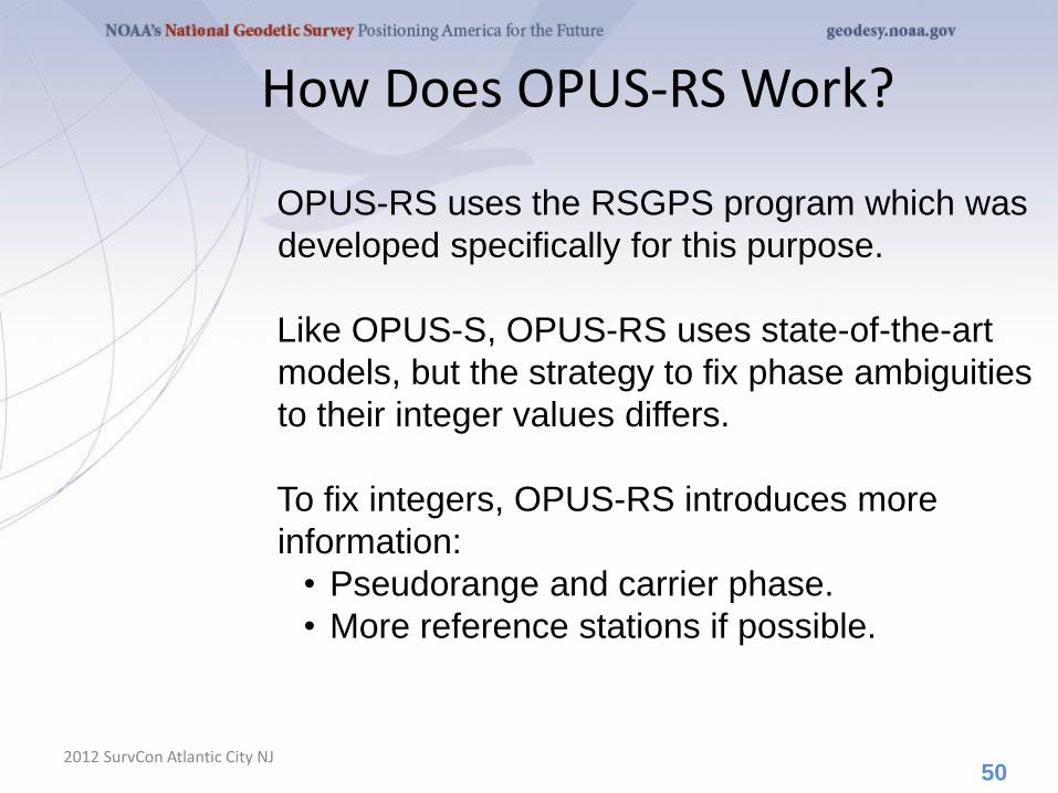
OPUS-RS uses the RSGPS program which was
developed specifically for this purpose.
Like OPUS-S, OPUS-RS uses state-of-the-art
models, but the strategy to fix phase ambiguities
to their integer values differs.
To fix integers, OPUS-RS introduces more
information:
• Pseudorange and carrier phase.
• More reference stations if possible.
50

How Does OPUS-RS Work?
2012 SurvCon Atlantic City NJ
OPUS-RS selects three to nine “best” CORS based upon:
• Having common satellite visibility with the user data.
• Having distances from the user’s site <250 km.
This is shown here graphically.
The star represents the user’s
site. The triangles are CORS.
No CORS farther than 250 km
from the user’s site will be
included.
The three CORS minimum is shown.
No more than nine are used.
51
s 250km
Choi, 2010, personal communication.
How Does OPUS-RS Work?
2012 SurvCon Atlantic City NJ
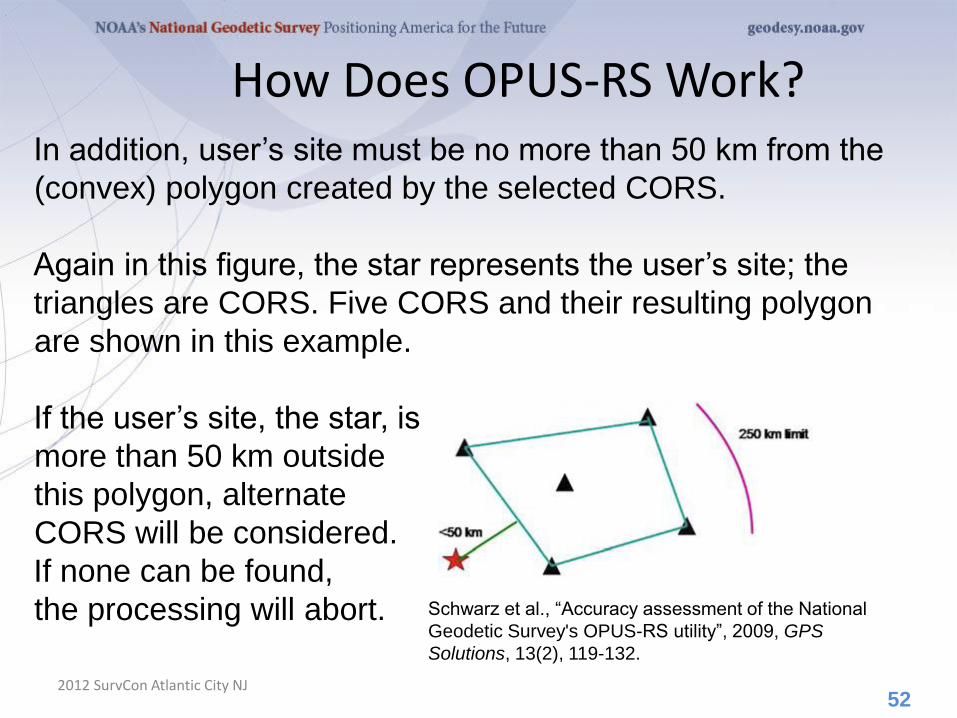
In addition, user’s site must be no more than 50 km from the
(convex) polygon created by the selected CORS.
Again in this figure, the star represents the user’s site; the
triangles are CORS. Five CORS and their resulting polygon
are shown in this example.
If the user’s site, the star, is
more than 50 km outside
this polygon, alternate
CORS will be considered.
If none can be found,
the processing will abort.
52
Schwarz et al., “Accuracy assessment of the National
Geodetic Survey's OPUS-RS utility”, 2009, GPS
Solutions, 13(2), 119-132.

How Does OPUS-RS Work?
2012 SurvCon Atlantic City NJ
OPUS-RS uses no less than 1-hour of CORS data and no
more than the submitted data’s span plus 15-minutes before
and after.
The CORS data are used to estimate the atmospheric delays
at each CORS and predict them at the user’s site.
OPUS-RS then processes each baseline to the user’s site
individually to produce an improved a priori position.
Switching modes, the previously determined values and all
data are used in an “integer-fixed” solution for the user’s site.
Schwarz et al., “Accuracy assessment of the National Geodetic Survey's OPUS-RS utility”, 2009, GPS
Solutions, 13(2), 119-132.
53

OPUS static vs. rapid static
static rapid static
input (dual-frequency GPS) 2-48 hours 15 minutes-2 hours
output normal, extended, XML
datasheet, project
normal, extended, XML
accuracy (95%confidence) 1-2 cm horizontal
3-6 cm ellipsoidal height
1-2 cm horizontal
4-8 cm ellipsoidal height
network geometry 3 CORS, preferably
within 1000 km of rover
3-9 CORS, surrounding &
within 250 km of rover
availability global
90% of CONUS (subject to CORS configuration)
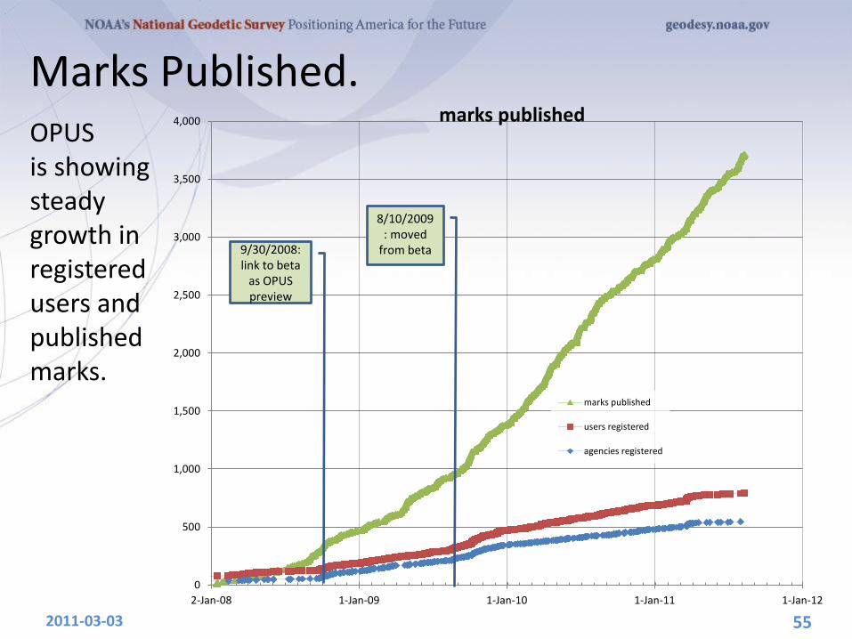
Marks Published.
2011-03-03 55
OPUS is showing steady growth in registered users and published marks.
0
500
1,000
1,500
2,000
2,500
3,000
3,500
4,000
2-Jan-08 1-Jan-09 1-Jan-10 1-Jan-11 1-Jan-12
marks published
marks published
users registered
agencies registered
9/30/2008: link to beta
as OPUS preview
8/10/2009: moved
from beta
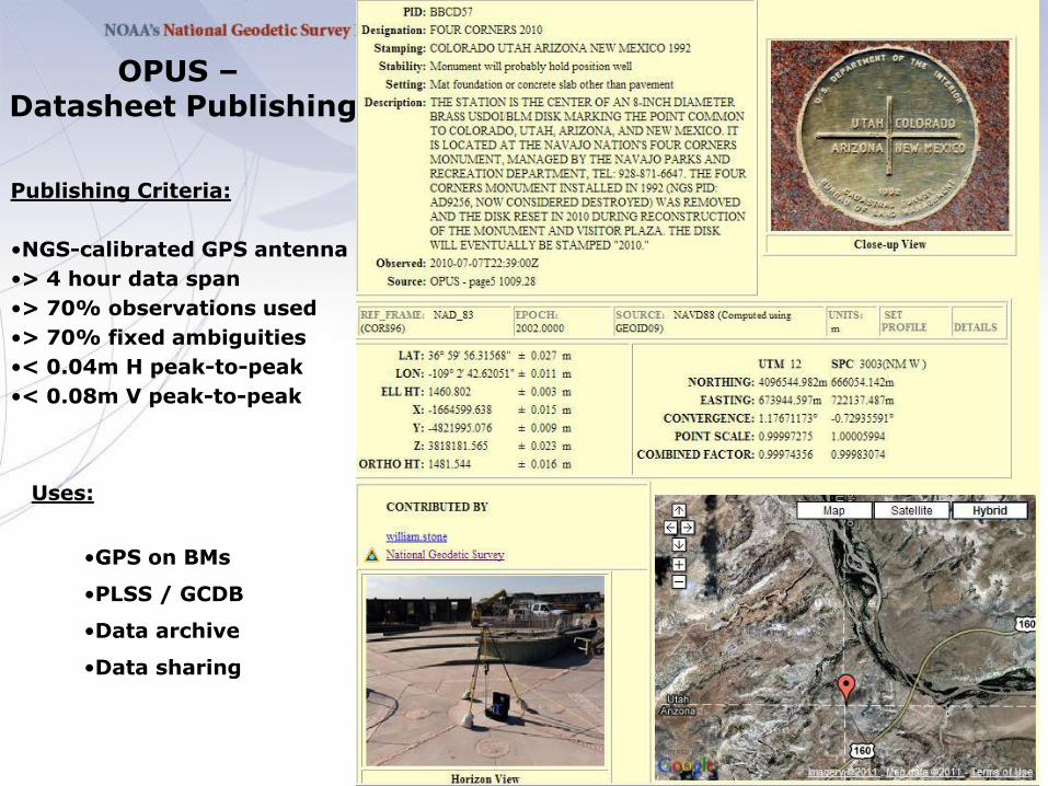
OPUS – Datasheet Publishing
Publishing Criteria:
•NGS-calibrated GPS antenna
•> 4 hour data span
•> 70% observations used
•> 70% fixed ambiguities
•< 0.04m H peak-to-peak
•< 0.08m V peak-to-peak
Uses:
•GPS on BMs
•PLSS / GCDB
•Data archive
•Data sharing
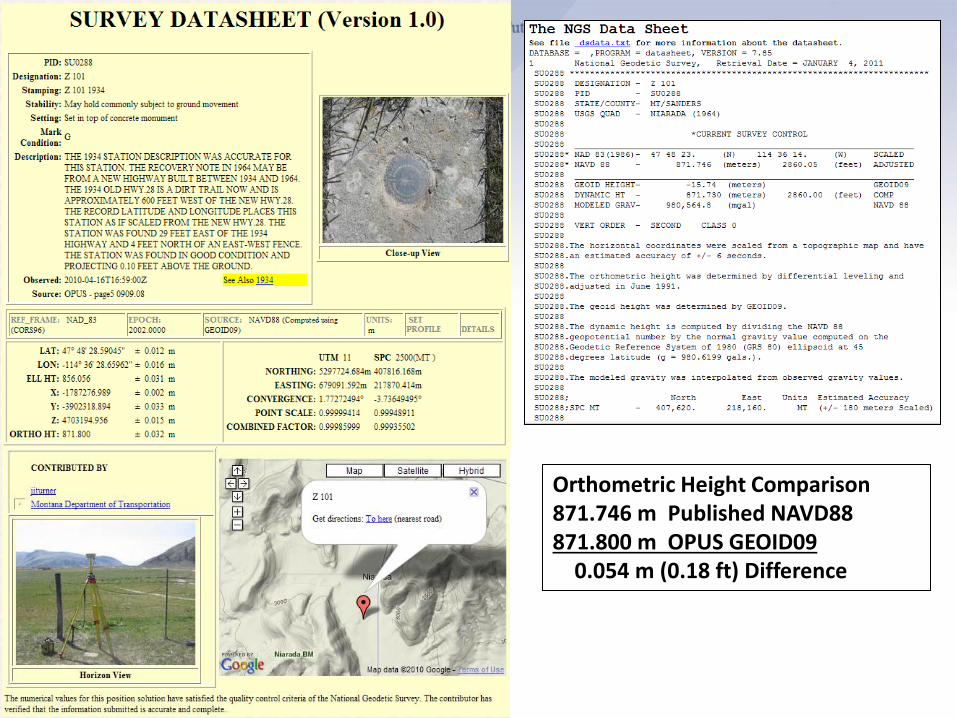
Orthometric Height Comparison 871.746 m Published NAVD88 871.800 m OPUS GEOID09 0.054 m (0.18 ft) Difference

ITRF2008, IGS08 AND NAD 83(2011)
2012 SurvCon Atlantic City NJ
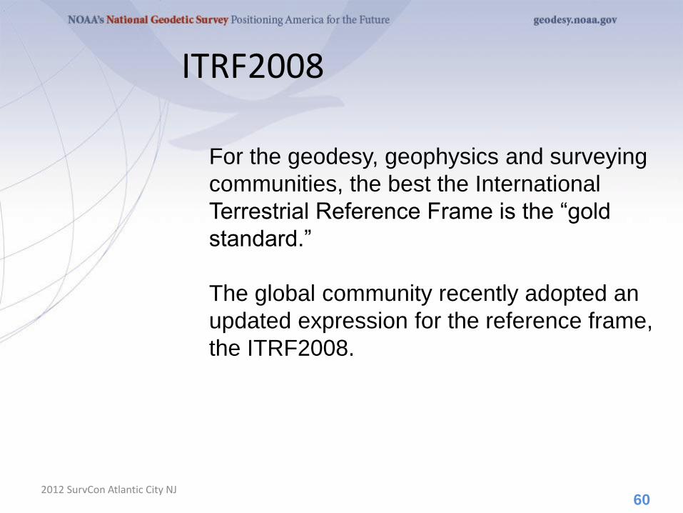
ITRF2008
2012 SurvCon Atlantic City NJ 60
For the geodesy, geophysics and surveying
communities, the best the International
Terrestrial Reference Frame is the “gold
standard.”
The global community recently adopted an
updated expression for the reference frame,
the ITRF2008.

Densification
2012 SurvCon Atlantic City NJ 61
The ITRF2008 is expressed through the
coordinates and velocities of marks on the
ground plus ancillary data.
Other organizations can take that information,
add additional marks, perform their own
adjustment and align their results to the
ITRF2008 (A.K.A. densifying).
The variants try to be as consistent with the
ITRF2008 as possible, but in the most formal
sense, they are unique from the ITRF2008.
Therefore, they are given unique names.

The IGS has densified reference frame with
much larger, global subset of GNSS tracking
sites thereby creating a GNSS-only expression
of the ITRF2008 called the IGS08. All IGS
products have been recreated so as to be
consistent with the IGS08 including GNSS
ephemerides and antenna models. Information
about the IGS08 can be found at the IGS web
sites: igscb.jpl.nasa.gov. I would suggest
starting with IGSMAIL‐6354, ‐6355 and ‐6356,
all dated 2011‐03‐07.
62
The IGS08
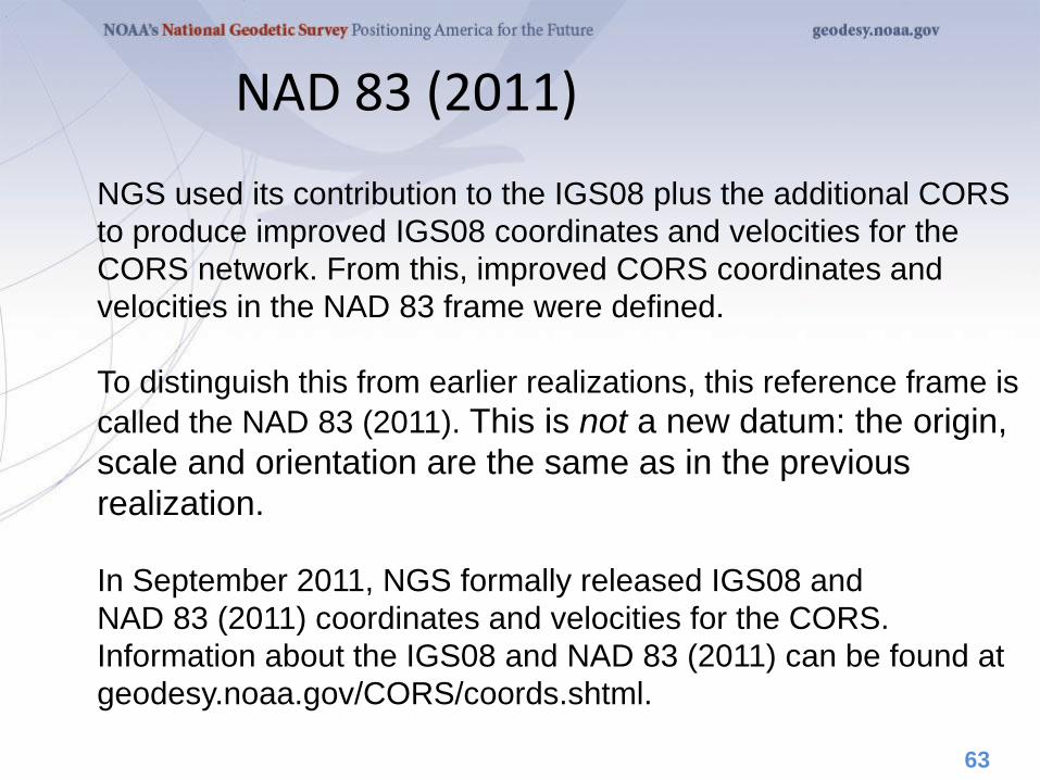
NGS used its contribution to the IGS08 plus the additional CORS
to produce improved IGS08 coordinates and velocities for the
CORS network. From this, improved CORS coordinates and
velocities in the NAD 83 frame were defined.
To distinguish this from earlier realizations, this reference frame is
called the NAD 83 (2011). This is not a new datum: the origin,
scale and orientation are the same as in the previous
realization.
In September 2011, NGS formally released IGS08 and
NAD 83 (2011) coordinates and velocities for the CORS.
Information about the IGS08 and NAD 83 (2011) can be found at
geodesy.noaa.gov/CORS/coords.shtml.
63
NAD 83 (2011)
64
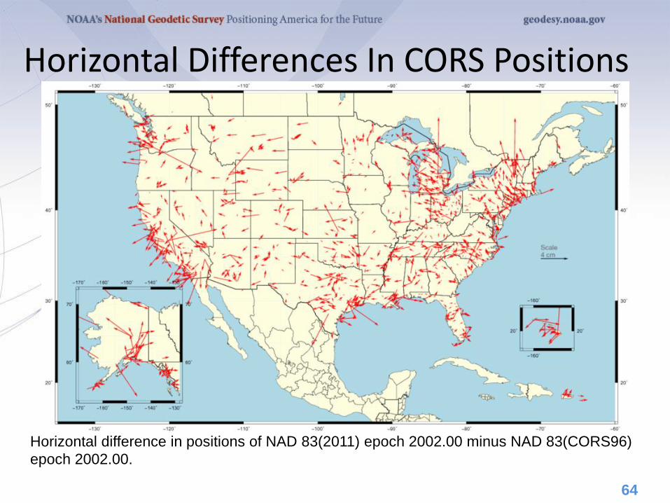
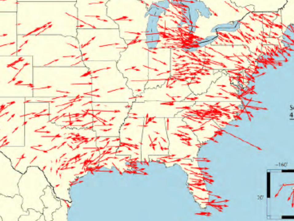
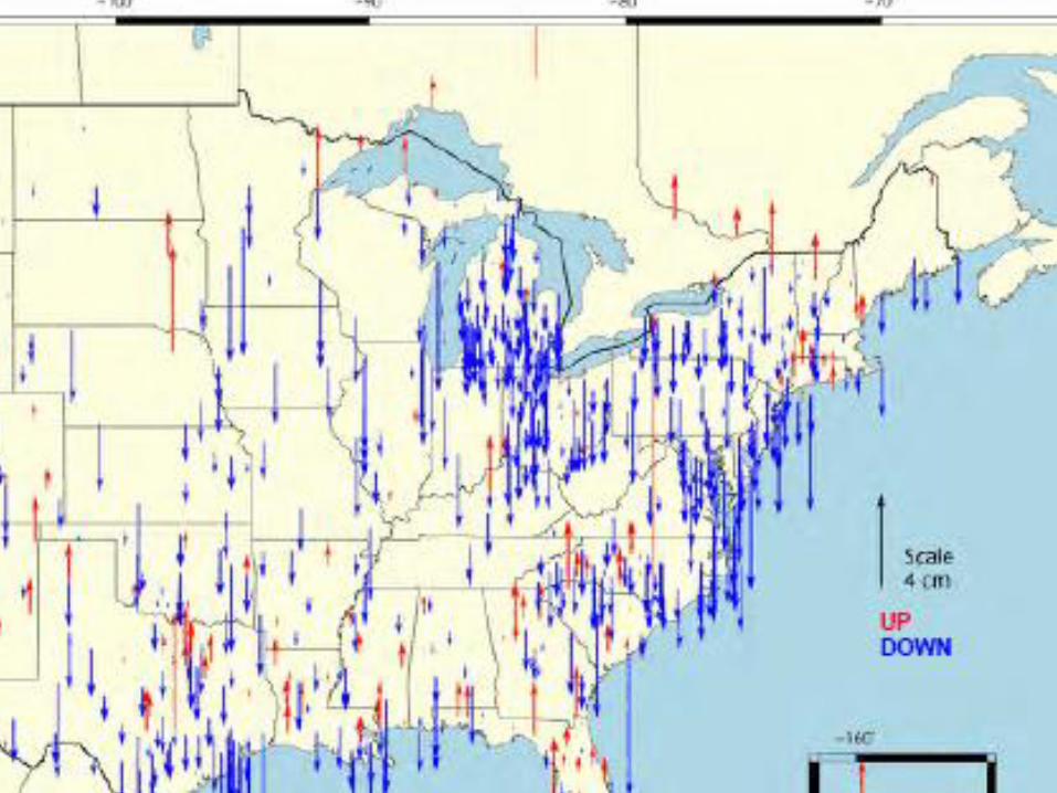
Horizontal Differences In CORS Positions
Horizontal difference in positions of NAD 83(2011) epoch 2002.00 minus NAD 83(CORS96)
epoch 2002.00.
65
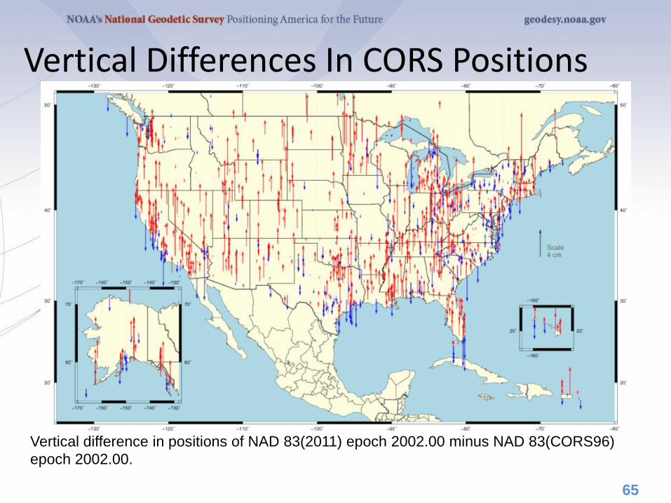
Vertical Differences In CORS Positions
Vertical difference in positions of NAD 83(2011) epoch 2002.00 minus NAD 83(CORS96)
epoch 2002.00.
The OPUS also began offering results in the IGS08 and
NAD 83(2011) reference frames in September 2011.
Although the NAD 83 (2011) is not a new datum, the CORS
coordinates used by OPUS in generating its results are different.
NGS recognizes that this change poses a challenge for some. To
help those users confidently switch to the new references frames,
OPUS users can choose to have their results reported in the
IGS08 and NAD 83(2011) or in the previous ITRF2000 and NAD
83 (CORS96). But users are strongly encouraged to switch to the
improved datum as soon as possible. This transition period will end
after a few months.
A short FAQ about this change can be found on the OPUS page:
geodesy.noaa.gov/OPUS/.
66
NAD 83 (2011) And OPUS
In addition, 80,000+ passive control marks are being readjusted to
provide the best possible consistency with the improved CORS
coordinates and velocities. Known as the National Adjustment of
2011 (NA2011), these results will be released by the end of 2011.
A new hybrid geoid model (likely named GEOID12) is being
produced too and will be released shortly after or in
conjunction with the NA2011 results.
For more information, visit
geodesy.noaa.gov/web/news/NA2011_Project.shtml
geodesy.noaa.gov/web/surveys/NA2011/NA2011_FAQ.shtml
67
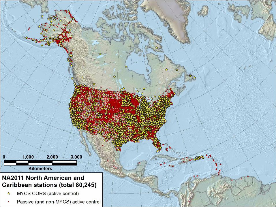
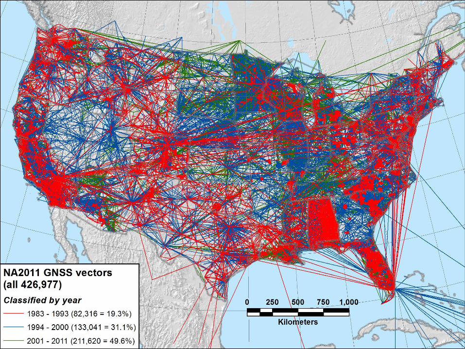
NAD 83 (2011) And Passive Control Marks
An improvement of the National Spatial Reference system.
NA2011 will yield updated NAD 83 coordinates on nearly 80,000 NGS passive control marks positioned using Global Navigation Satellite System (GNSS) technology.
Covering CONUS, AK, Caribbean, and Pacific region.
National Adjustment of 2011
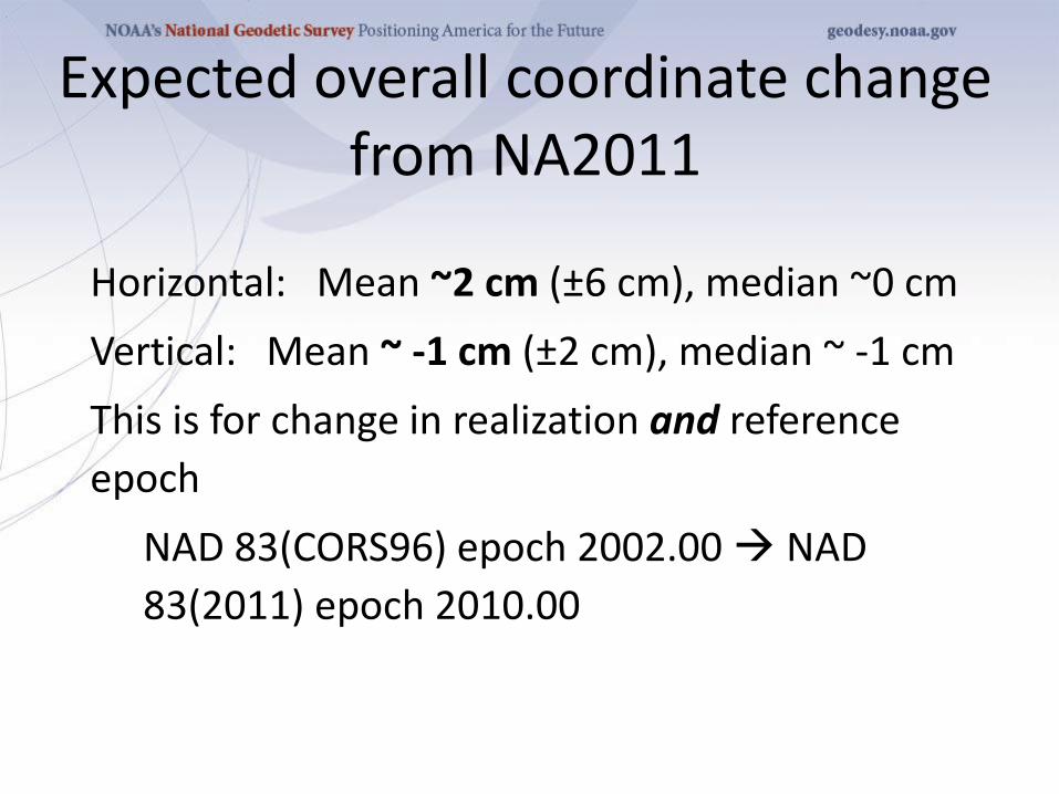
Horizontal: Mean ~2 cm (±6 cm), median ~0 cm
Vertical: Mean ~ -1 cm (±2 cm), median ~ -1 cm
This is for change in realization and reference
epoch
NAD 83(CORS96) epoch 2002.00 NAD
83(2011) epoch 2010.00
Expected overall coordinate change from NA2011
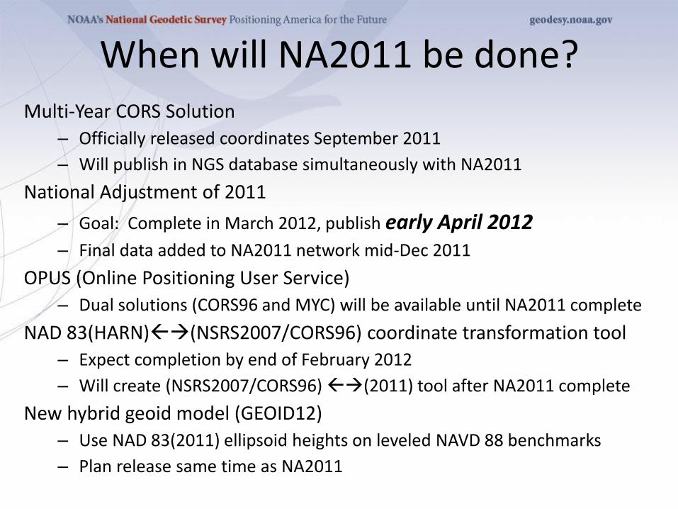
When will NA2011 be done? Multi-Year CORS Solution
– Officially released coordinates September 2011
– Will publish in NGS database simultaneously with NA2011
National Adjustment of 2011
– Goal: Complete in March 2012, publish early April 2012 – Final data added to NA2011 network mid-Dec 2011
OPUS (Online Positioning User Service)
– Dual solutions (CORS96 and MYC) will be available until NA2011 complete
NAD 83(HARN)(NSRS2007/CORS96) coordinate transformation tool
– Expect completion by end of February 2012
– Will create (NSRS2007/CORS96) (2011) tool after NA2011 complete
New hybrid geoid model (GEOID12)
– Use NAD 83(2011) ellipsoid heights on leveled NAVD 88 benchmarks
– Plan release same time as NA2011
OPUS-NET
2012 SurvCon Atlantic City NJ

OPUS-Net
2012 SurvCon Atlantic City NJ
Weston and Ray (NGS) have found that by more fully
implementing the available processing models in conjunction
with changing the CORS selection criteria, at a minimum the
scatter in the north and east components can be significantly
reduced with no degradation in the scatter in the height
produced by OPUS-S.
Moreover, the resulting coordinates agree better with other
sources such as the IGS weekly combinations.
Weston and Ray, “Test of the Use of Regional Networks for OPUS Processing”, 2010, EGU General
Assembly 2010, Geophysical Research Abstracts.
76
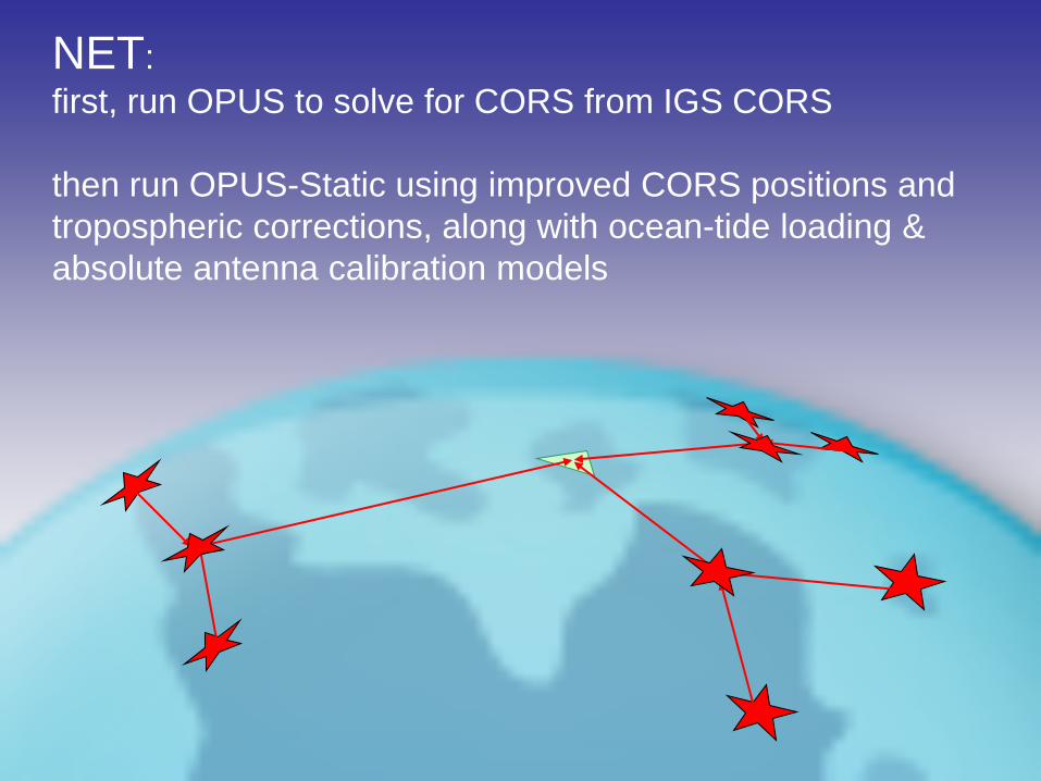
NET:
first, run OPUS to solve for CORS from IGS CORS
then run OPUS-Static using improved CORS positions and
tropospheric corrections, along with ocean-tide loading &
absolute antenna calibration models
OPUS-Net
2012 SurvCon Atlantic City NJ
This processing strategy was implemented in an
OPUS-like application, called OPUS-Net during its
testing phase. It includes
• An ocean-tide loading (OTL) model.
• Absolute antenna phase correction models.
• A combination of near-by and more-distant
CORS.
Let’s look at these individually.
78
OPUS-Net
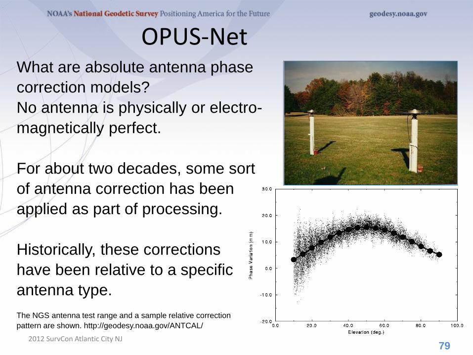
2012 SurvCon Atlantic City NJ
What are absolute antenna phase
correction models?
No antenna is physically or electro-
magnetically perfect.
For about two decades, some sort
of antenna correction has been
applied as part of processing.
Historically, these corrections
have been relative to a specific
antenna type.
The NGS antenna test range and a sample relative correction
pattern are shown. http://geodesy.noaa.gov/ANTCAL/
79
OPUS-Net
2012 SurvCon Atlantic City NJ
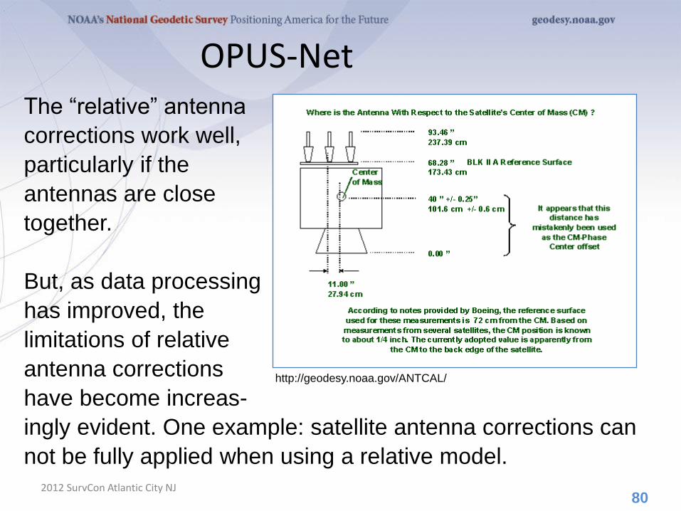
The “relative” antenna
corrections work well,
particularly if the
antennas are close
together.
But, as data processing
has improved, the
limitations of relative
antenna corrections
have become increas-
ingly evident. One example: satellite antenna corrections can
not be fully applied when using a relative model.
80
http://geodesy.noaa.gov/ANTCAL/
OPUS-Net
2012 SurvCon Atlantic City NJ
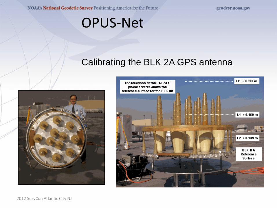
Calibrating the BLK 2A GPS antenna
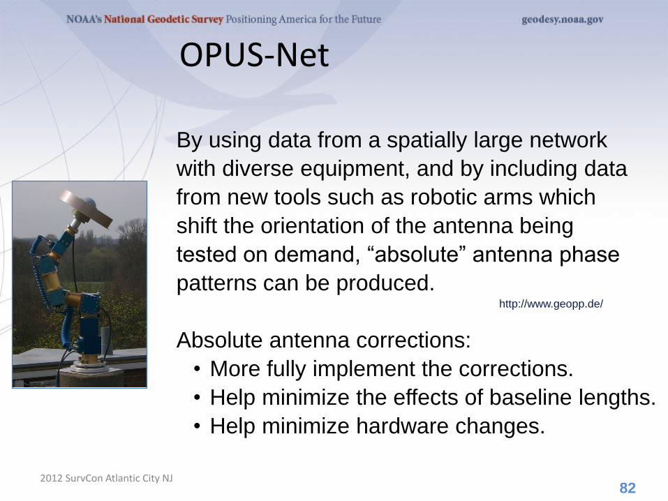
By using data from a spatially large network
with diverse equipment, and by including data
from new tools such as robotic arms which
shift the orientation of the antenna being
tested on demand, “absolute” antenna phase
patterns can be produced.
Absolute antenna corrections:
• More fully implement the corrections.
• Help minimize the effects of baseline lengths.
• Help minimize hardware changes.
OPUS-Net
2012 SurvCon Atlantic City NJ 82
http://www.geopp.de/
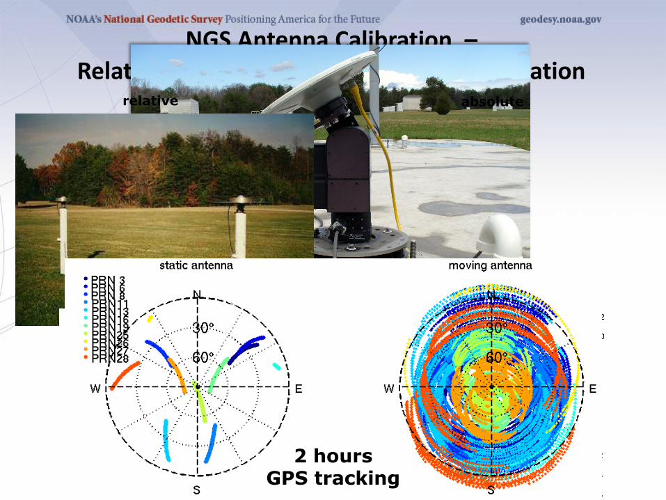
NGS Antenna Calibration – Relative vs. Absolute GNSS Antenna Calibration
relative absolute
2 hours GPS tracking
-0.01
-0.008
-0.006
-0.004
-0.002
0
0.002
0.004
0.006
0.008
0.01
-0.01 -0.008 -0.006 -0.004 -0.002 0 0.002 0.004 0.006 0.008 0.01
Phase center offset from ARP, meters
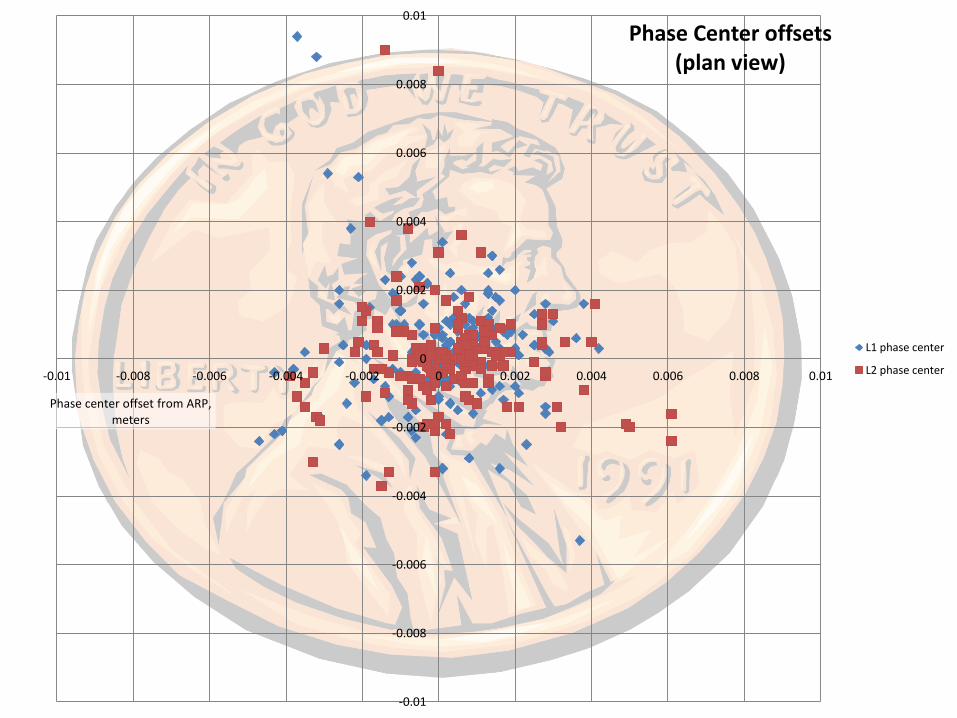
Phase Center offsets (plan view)
L1 phase center
L2 phase center
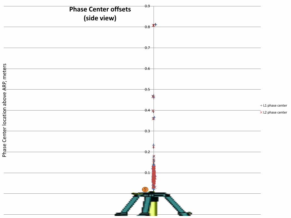
-0.1
0
0.1
0.2
0.3
0.4
0.5
0.6
0.7
0.8
0.9P
has
e C
ente
r lo
cati
on
ab
ove
AR
P, m
eter
s Phase Center offsets
(side view)
L1 phase center
L2 phase center
-0.03
-0.02
-0.01
0
0.01
0.02
0.03
0.04
0.05
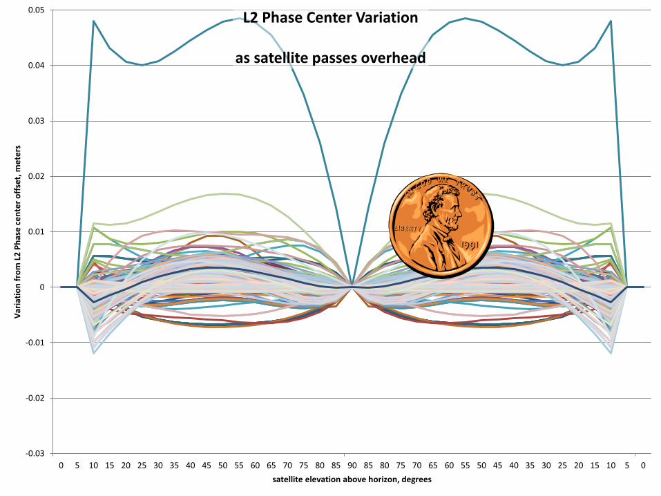
0 5 10 15 20 25 30 35 40 45 50 55 60 65 70 75 80 85 90 85 80 75 70 65 60 55 50 45 40 35 30 25 20 15 10 5 0
Var
iati
on
fro
m L
2 P
has
e c
en
ter
off
set,
me
ters
satellite elevation above horizon, degrees
L2 Phase Center Variation
as satellite passes overhead
Why use near-by and more-distant CORS?
Although it may seem counter-intuitive, using a
combination
of near and distant CORS has a number of
advantages.
• CORS “quality” can be emphasized as well
as data quantity.
• Longer baselines enable better atmosphere
corrections.
• More CORS minimizes the effects of missing
data and changes.
OPUS-Net
2012 SurvCon Atlantic City NJ 87
OPUS-MAPPER
2012 SurvCon Atlantic City NJ

Traditionally, NGS products have supported higher-accuracy
uses: conventional surveying, geodetic and geophysical
research, et cetera. Nevertheless, these products also support
other uses such as GIS, kinematic and hand-held tracking to
list a few.
To support activities that are dynamic by their very nature and
often depend upon short latency, OPUS seems an appropriate
gateway.
But, do we need another flavor of OPUS?
The answer is unclear, but may be yes. A limited accuracy
application fits nicely into NGS plans and may be a valuable
service to this large user community.
OPUS-Mapper
2012 SurvCon Atlantic City NJ 89

OPUS-Mapper
2012 SurvCon Atlantic City NJ 90
mm cm dm m dam hm km
# of
People
Who
Care
Position Accuracy
NGS
Works
Here
GIS
Works
Here
Mader and Weston, “An On-Line Positioning User Service For Geographic Information
Systems”, 2007, 2007 ESRI Survey & Engineering GIS Summit.
OPUS-Mapper
2012 SurvCon Atlantic City NJ 91
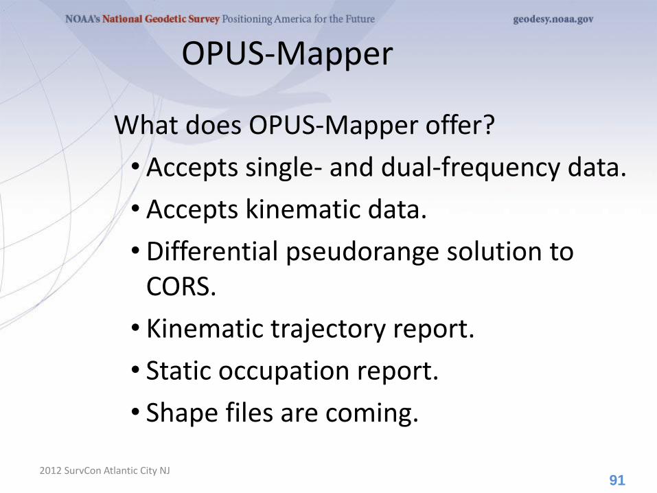
What does OPUS-Mapper offer?
• Accepts single- and dual-frequency data.
• Accepts kinematic data.
• Differential pseudorange solution to CORS.
• Kinematic trajectory report.
• Static occupation report.
• Shape files are coming.
OPUS-Mapper
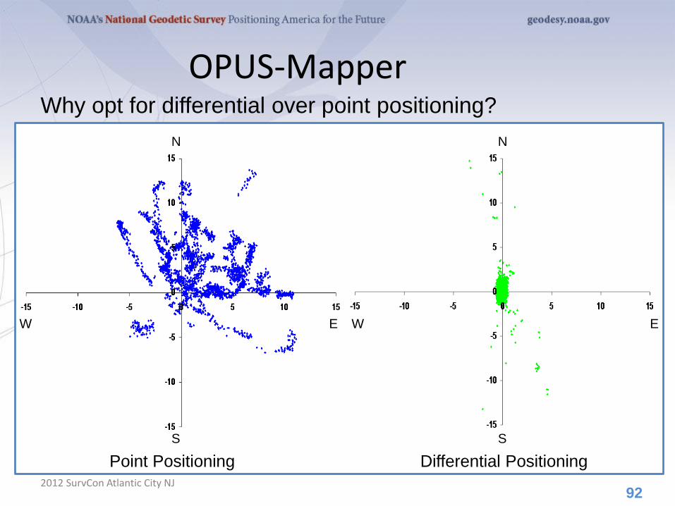
2012 SurvCon Atlantic City NJ 92
N N
S S
E E W W
Why opt for differential over point positioning?
Point Positioning Differential Positioning
OPUS-Mapper
2012 SurvCon Atlantic City NJ 93
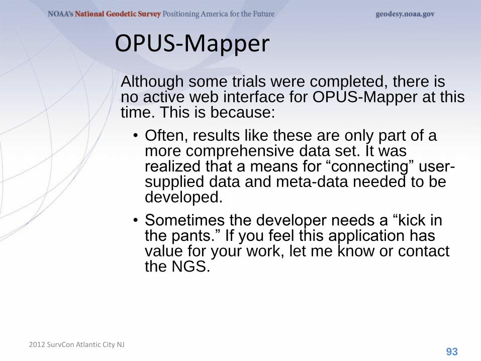
Although some trials were completed, there is no active web interface for OPUS-Mapper at this time. This is because:
• Often, results like these are only part of a more comprehensive data set. It was realized that a means for “connecting” user-supplied data and meta-data needed to be developed.
• Sometimes the developer needs a “kick in the pants.” If you feel this application has value for your work, let me know or contact the NGS.
OPUS-Mapper
2012 SurvCon Atlantic City NJ 94
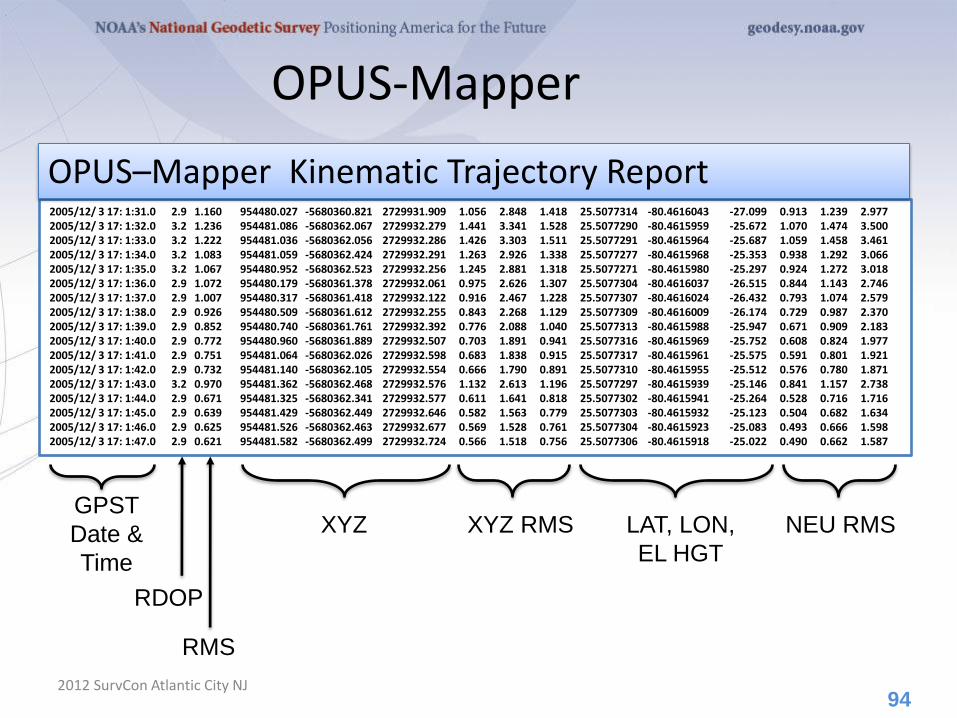
2005/12/ 3 17: 1:31.0 2.9 1.160 954480.027 -5680360.821 2729931.909 1.056 2.848 1.418 25.5077314 -80.4616043 -27.099 0.913 1.239 2.977 2005/12/ 3 17: 1:32.0 3.2 1.236 954481.086 -5680362.067 2729932.279 1.441 3.341 1.528 25.5077290 -80.4615959 -25.672 1.070 1.474 3.500 2005/12/ 3 17: 1:33.0 3.2 1.222 954481.036 -5680362.056 2729932.286 1.426 3.303 1.511 25.5077291 -80.4615964 -25.687 1.059 1.458 3.461 2005/12/ 3 17: 1:34.0 3.2 1.083 954481.059 -5680362.424 2729932.291 1.263 2.926 1.338 25.5077277 -80.4615968 -25.353 0.938 1.292 3.066 2005/12/ 3 17: 1:35.0 3.2 1.067 954480.952 -5680362.523 2729932.256 1.245 2.881 1.318 25.5077271 -80.4615980 -25.297 0.924 1.272 3.018 2005/12/ 3 17: 1:36.0 2.9 1.072 954480.179 -5680361.378 2729932.061 0.975 2.626 1.307 25.5077304 -80.4616037 -26.515 0.844 1.143 2.746 2005/12/ 3 17: 1:37.0 2.9 1.007 954480.317 -5680361.418 2729932.122 0.916 2.467 1.228 25.5077307 -80.4616024 -26.432 0.793 1.074 2.579 2005/12/ 3 17: 1:38.0 2.9 0.926 954480.509 -5680361.612 2729932.255 0.843 2.268 1.129 25.5077309 -80.4616009 -26.174 0.729 0.987 2.370 2005/12/ 3 17: 1:39.0 2.9 0.852 954480.740 -5680361.761 2729932.392 0.776 2.088 1.040 25.5077313 -80.4615988 -25.947 0.671 0.909 2.183 2005/12/ 3 17: 1:40.0 2.9 0.772 954480.960 -5680361.889 2729932.507 0.703 1.891 0.941 25.5077316 -80.4615969 -25.752 0.608 0.824 1.977 2005/12/ 3 17: 1:41.0 2.9 0.751 954481.064 -5680362.026 2729932.598 0.683 1.838 0.915 25.5077317 -80.4615961 -25.575 0.591 0.801 1.921 2005/12/ 3 17: 1:42.0 2.9 0.732 954481.140 -5680362.105 2729932.554 0.666 1.790 0.891 25.5077310 -80.4615955 -25.512 0.576 0.780 1.871 2005/12/ 3 17: 1:43.0 3.2 0.970 954481.362 -5680362.468 2729932.576 1.132 2.613 1.196 25.5077297 -80.4615939 -25.146 0.841 1.157 2.738 2005/12/ 3 17: 1:44.0 2.9 0.671 954481.325 -5680362.341 2729932.577 0.611 1.641 0.818 25.5077302 -80.4615941 -25.264 0.528 0.716 1.716 2005/12/ 3 17: 1:45.0 2.9 0.639 954481.429 -5680362.449 2729932.646 0.582 1.563 0.779 25.5077303 -80.4615932 -25.123 0.504 0.682 1.634 2005/12/ 3 17: 1:46.0 2.9 0.625 954481.526 -5680362.463 2729932.677 0.569 1.528 0.761 25.5077304 -80.4615923 -25.083 0.493 0.666 1.598 2005/12/ 3 17: 1:47.0 2.9 0.621 954481.582 -5680362.499 2729932.724 0.566 1.518 0.756 25.5077306 -80.4615918 -25.022 0.490 0.662 1.587
GPST
Date &
Time
RDOP
RMS
XYZ XYZ RMS LAT, LON,
EL HGT
NEU RMS
OPUS–Mapper Kinematic Trajectory Report
OPUS-Mapper
2012 SurvCon Atlantic City NJ 95
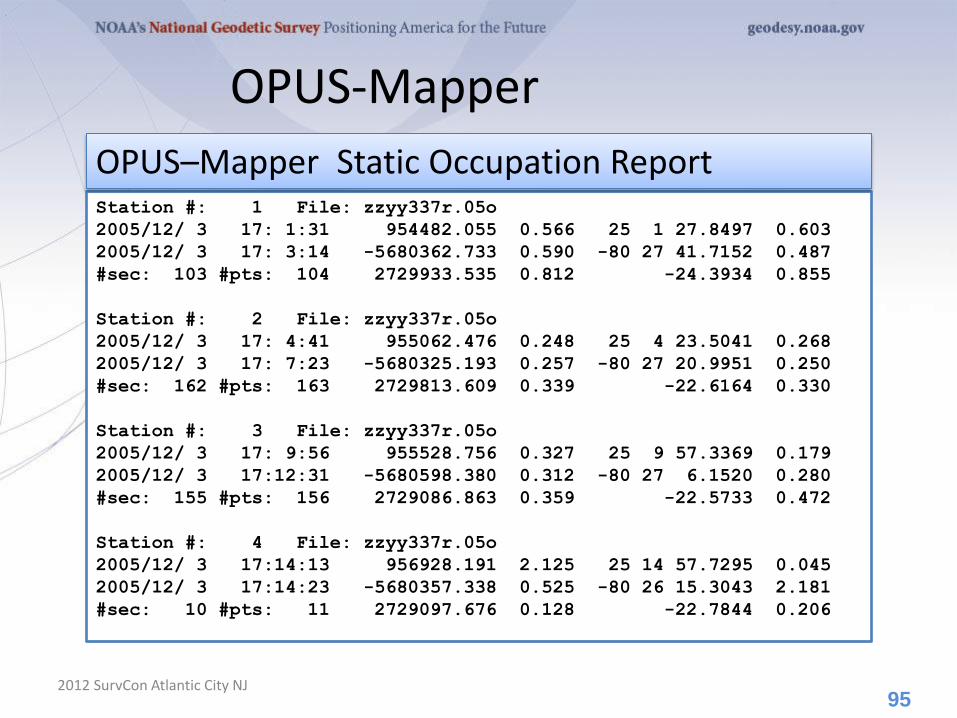
Station #: 1 File: zzyy337r.05o
2005/12/ 3 17: 1:31 954482.055 0.566 25 1 27.8497 0.603
2005/12/ 3 17: 3:14 -5680362.733 0.590 -80 27 41.7152 0.487
#sec: 103 #pts: 104 2729933.535 0.812 -24.3934 0.855
Station #: 2 File: zzyy337r.05o
2005/12/ 3 17: 4:41 955062.476 0.248 25 4 23.5041 0.268
2005/12/ 3 17: 7:23 -5680325.193 0.257 -80 27 20.9951 0.250
#sec: 162 #pts: 163 2729813.609 0.339 -22.6164 0.330
Station #: 3 File: zzyy337r.05o
2005/12/ 3 17: 9:56 955528.756 0.327 25 9 57.3369 0.179
2005/12/ 3 17:12:31 -5680598.380 0.312 -80 27 6.1520 0.280
#sec: 155 #pts: 156 2729086.863 0.359 -22.5733 0.472
Station #: 4 File: zzyy337r.05o
2005/12/ 3 17:14:13 956928.191 2.125 25 14 57.7295 0.045
2005/12/ 3 17:14:23 -5680357.338 0.525 -80 26 15.3043 2.181
#sec: 10 #pts: 11 2729097.676 0.128 -22.7844 0.206
OPUS–Mapper Static Occupation Report
96
A Little OPUS-Projects History
2012 SurvCon Atlantic City NJ
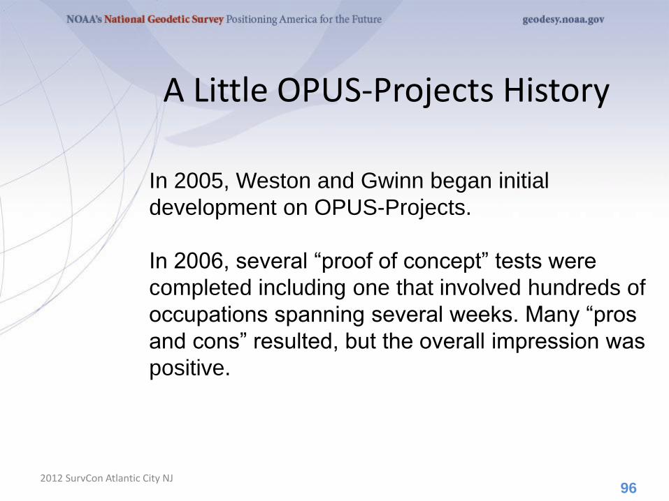
In 2005, Weston and Gwinn began initial
development on OPUS-Projects.
In 2006, several “proof of concept” tests were
completed including one that involved hundreds of
occupations spanning several weeks. Many “pros
and cons” resulted, but the overall impression was
positive.

What Is OPUS-Projects?
2012 SurvCon Atlantic City NJ
OPUS-Projects gives users web-based access to
simple visualization, management and processing
tools for multiple sites and multiple occupations.
These tools include:
• The advantages of data uploading through OPUS.
• Data visualization and management aids.
• Enhanced data processing using the PAGES suite.
• Solution visualization aids.
• Seamless connectivity with other OPUS tools.
97
What Is OPUS-Projects?
2012 SurvCon Atlantic City NJ
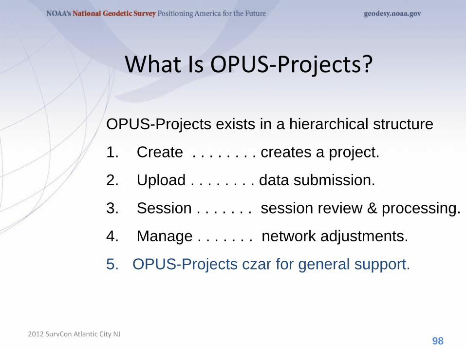
OPUS-Projects exists in a hierarchical structure
1. Create . . . . . . . . creates a project.
2. Upload . . . . . . . . data submission.
3. Session . . . . . . . session review & processing.
4. Manage . . . . . . . network adjustments.
5. OPUS-Projects czar for general support.
98
What Is OPUS-Projects?
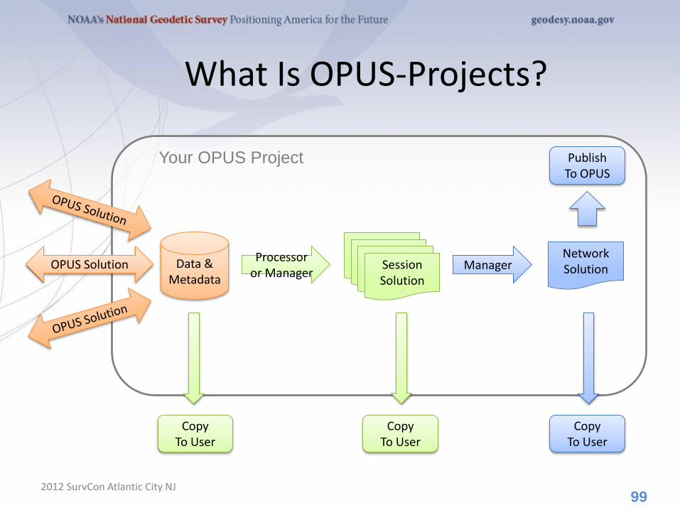
2012 SurvCon Atlantic City NJ 99
Processor or Manager
Data & Metadata
Network Solution Manager
Publish To OPUS
Session Solution
Session Solution
Session Solution
Session Solution
Copy To User
Your OPUS Project
Copy To User
Copy To User
OPUS Solution
The OPUS-Projects Interface
2012 SurvCon Atlantic City NJ
It’s probably easier to show the interface than
describe it, so let’s walk through some of the basic
steps in creating and reviewing a project.
100
Please be aware …
OPUS-Projects is actively being developed. The information shown here reflects many, but not all of the recent and pending changes.
101 2012 SurvCon Atlantic City NJ
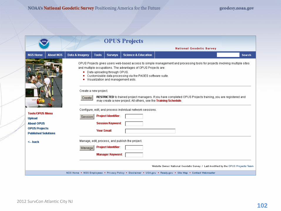
102 2012 SurvCon Atlantic City NJ

Your Project Identifier can be shared thereby permitting others to contribute data to your project.
103

UPLOADING DATA TO A PROJECT
2012 SurvCon Atlantic City NJ 104

The second step is to “Upload” data files to your
project.
At this time, this is done through OPUS-S implying
the same restrictions:
• Your data must be dual frequency pseudorange
and phase P1 (or C1), P2, L1 and L2.
• A minimum 2-hours data span for each
submission.
• A collection rate of 1, 2, 3, 5, 10, 15 or 30
seconds.
105
UPLOADING DATA TO A PROJECT
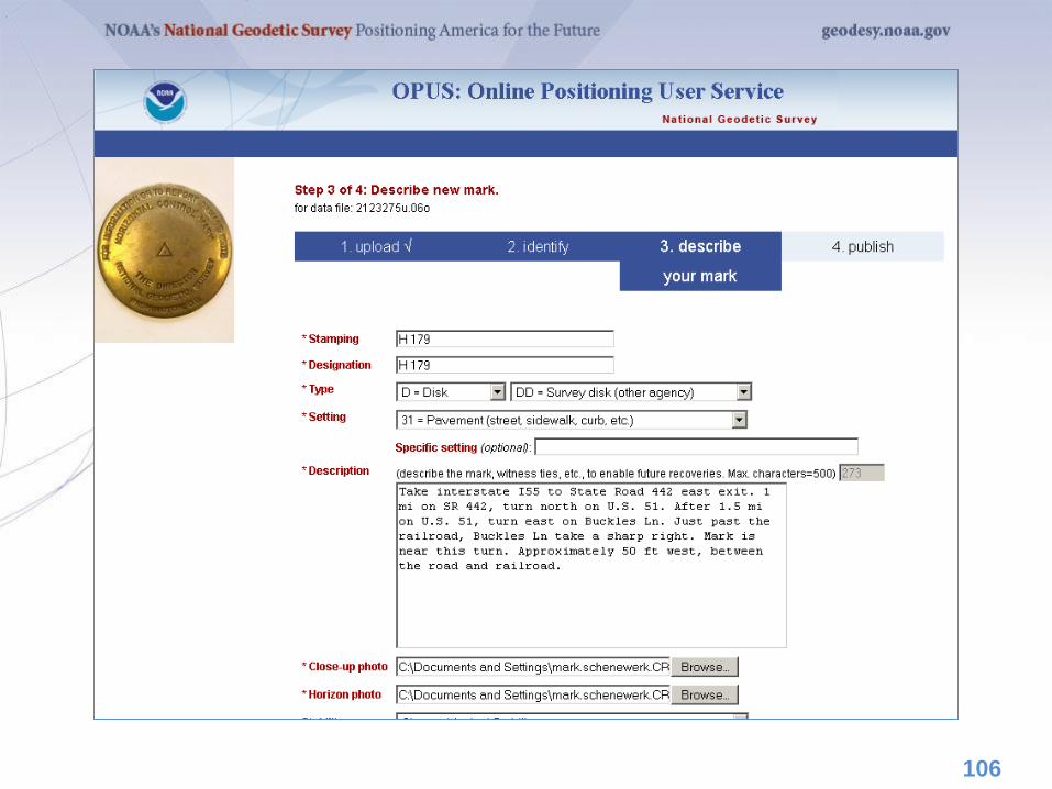
106
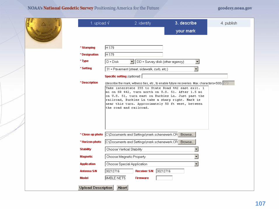
107
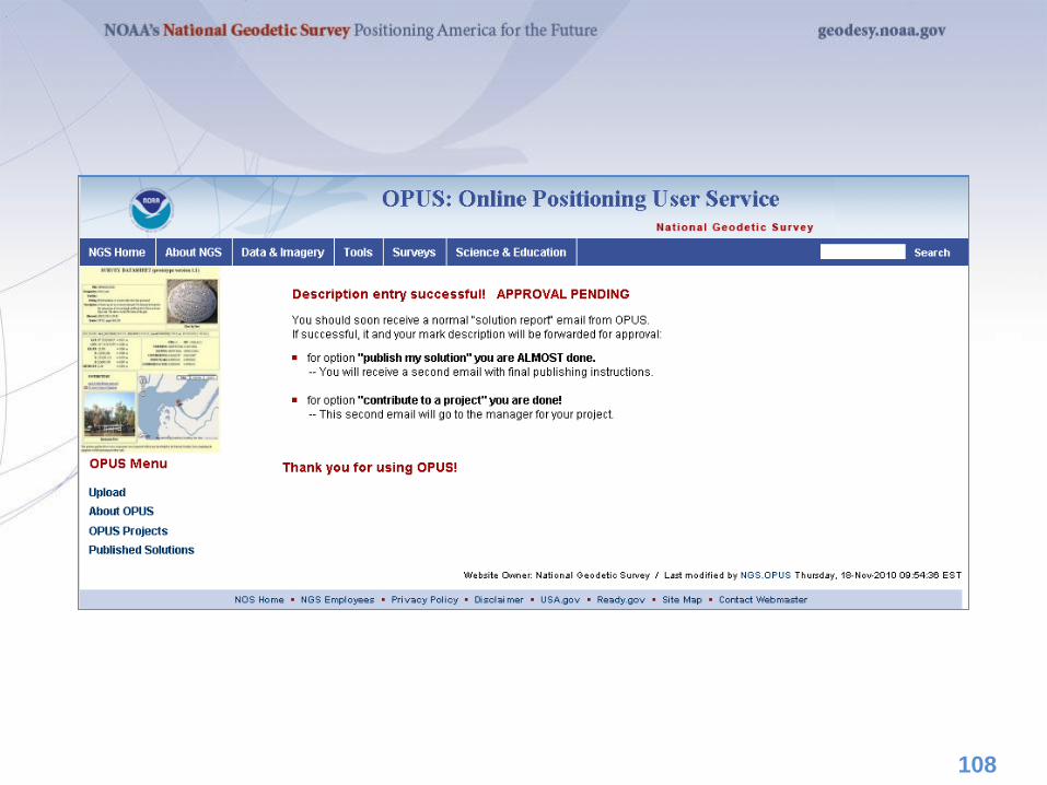
108
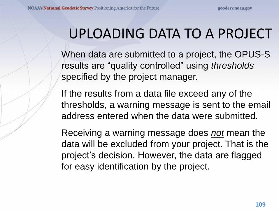
When data are submitted to a project, the OPUS-S
results are “quality controlled” using thresholds
specified by the project manager.
If the results from a data file exceed any of the
thresholds, a warning message is sent to the email
address entered when the data were submitted.
Receiving a warning message does not mean the
data will be excluded from your project. That is the
project’s decision. However, the data are flagged
for easy identification by the project.
109
UPLOADING DATA TO A PROJECT
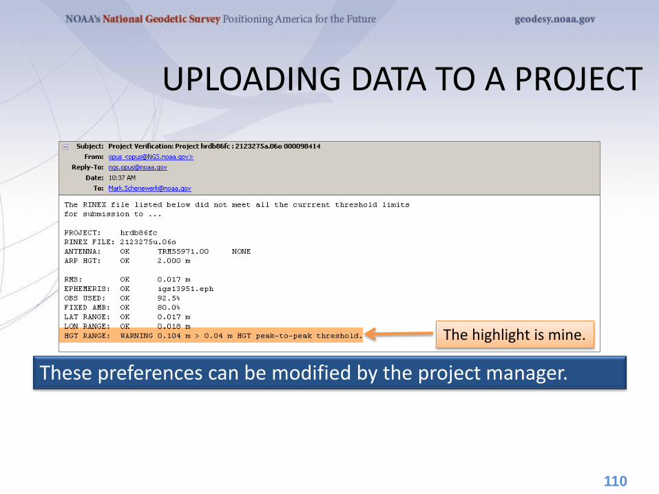
The highlight is mine.
110
These preferences can be modified by the project manager.
UPLOADING DATA TO A PROJECT
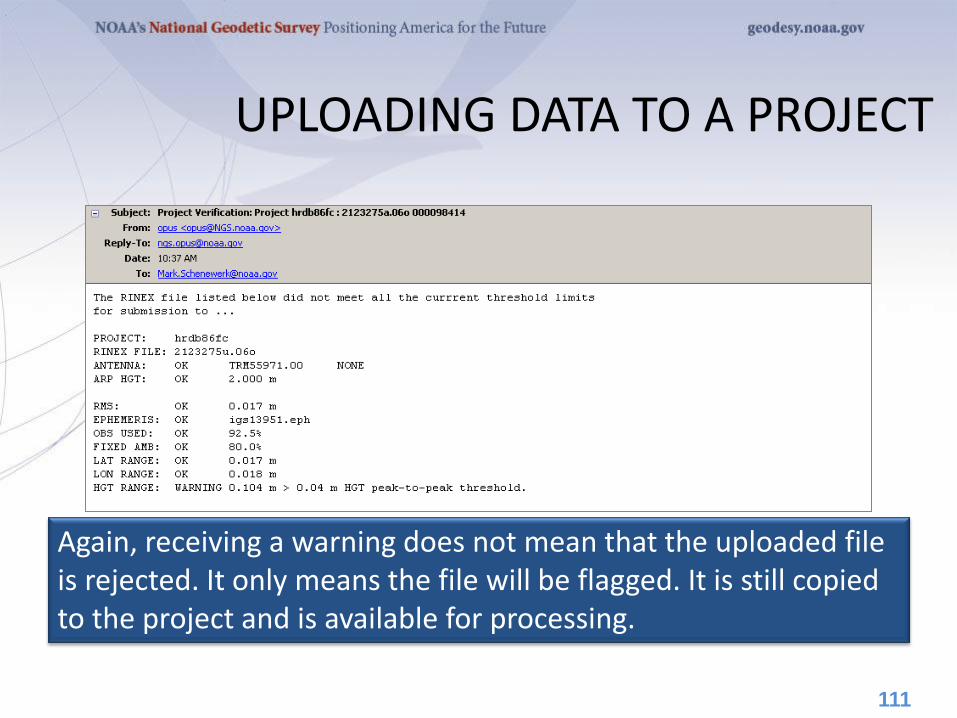
Again, receiving a warning does not mean that the uploaded file is rejected. It only means the file will be flagged. It is still copied to the project and is available for processing.
111
UPLOADING DATA TO A PROJECT
OPUS-Projects groups the data into sessions.
Sessions are groups of site occupations that overlap
significantly in time. Note that
• a site may appear in more than one session.
• as new data are submitted, the definitions of the
sessions may change.
Now that some data has been submitted to the
project, processing can begin.
112
VIEW & PROCESS A SESSION
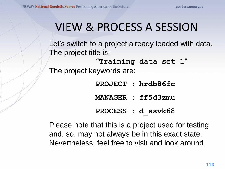
Let’s switch to a project already loaded with data. The project title is: “Training data set 1”
The project keywords are:
PROJECT : hrdb86fc
MANAGER : ff5d3zmu
PROCESS : d_ssvk68
Please note that this is a project used for testing
and, so, may not always be in this exact state.
Nevertheless, feel free to visit and look around.
113
VIEW & PROCESS A SESSION
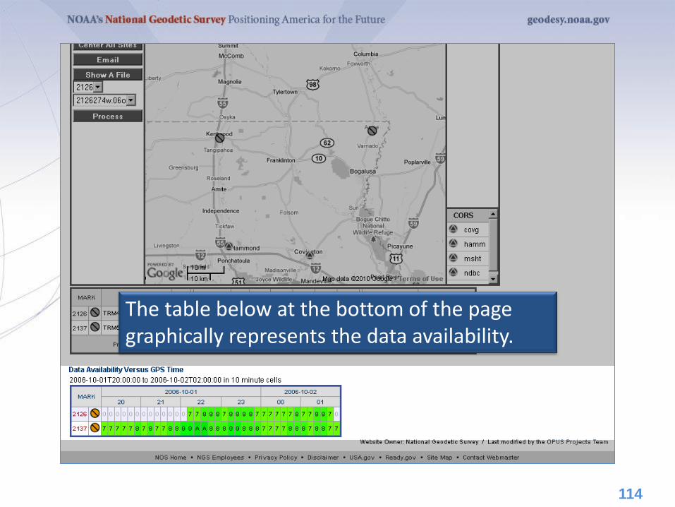
The table below at the bottom of the page graphically represents the data availability.
114
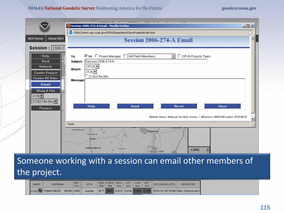
Someone working with a session can email other members of the project.
115
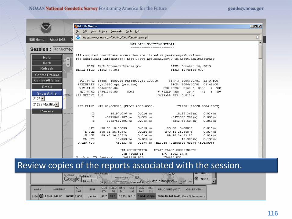
Review copies of the reports associated with the session.
116
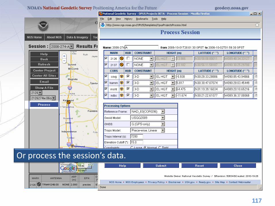
Or process the session’s data.
117
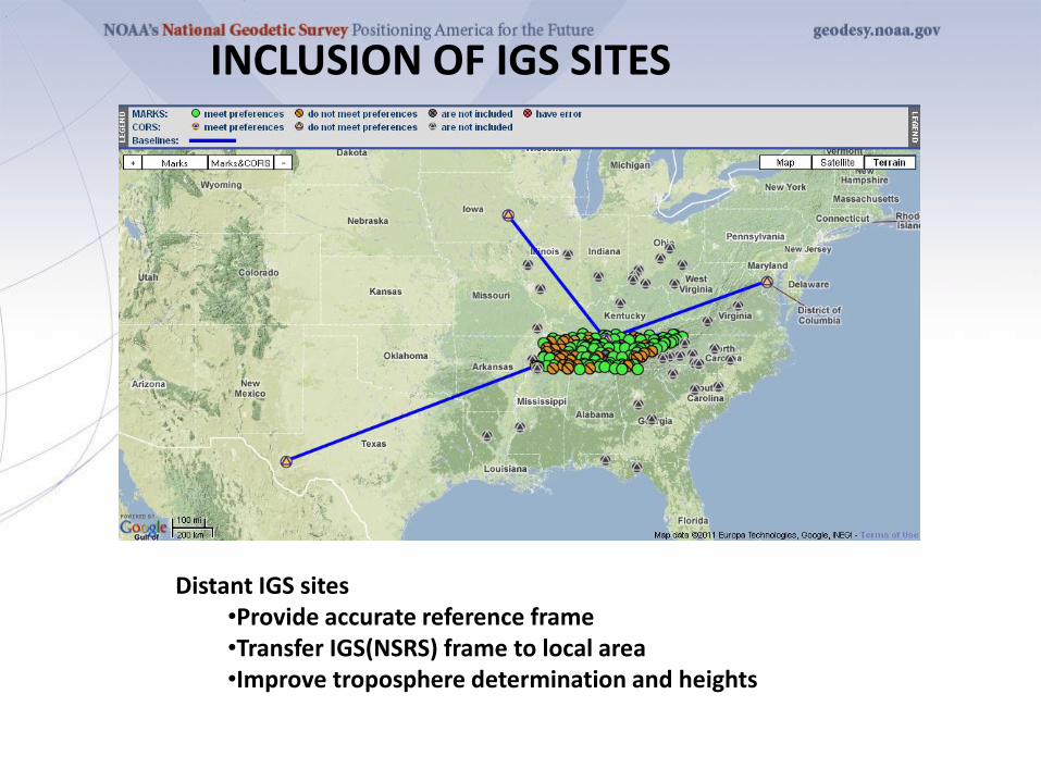
Distant IGS sites •Provide accurate reference frame •Transfer IGS(NSRS) frame to local area •Improve troposphere determination and heights
INCLUSION OF IGS SITES
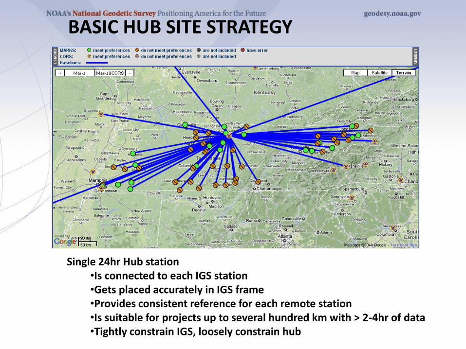
Single 24hr Hub station •Is connected to each IGS station •Gets placed accurately in IGS frame •Provides consistent reference for each remote station •Is suitable for projects up to several hundred km with > 2-4hr of data •Tightly constrain IGS, loosely constrain hub
BASIC HUB SITE STRATEGY
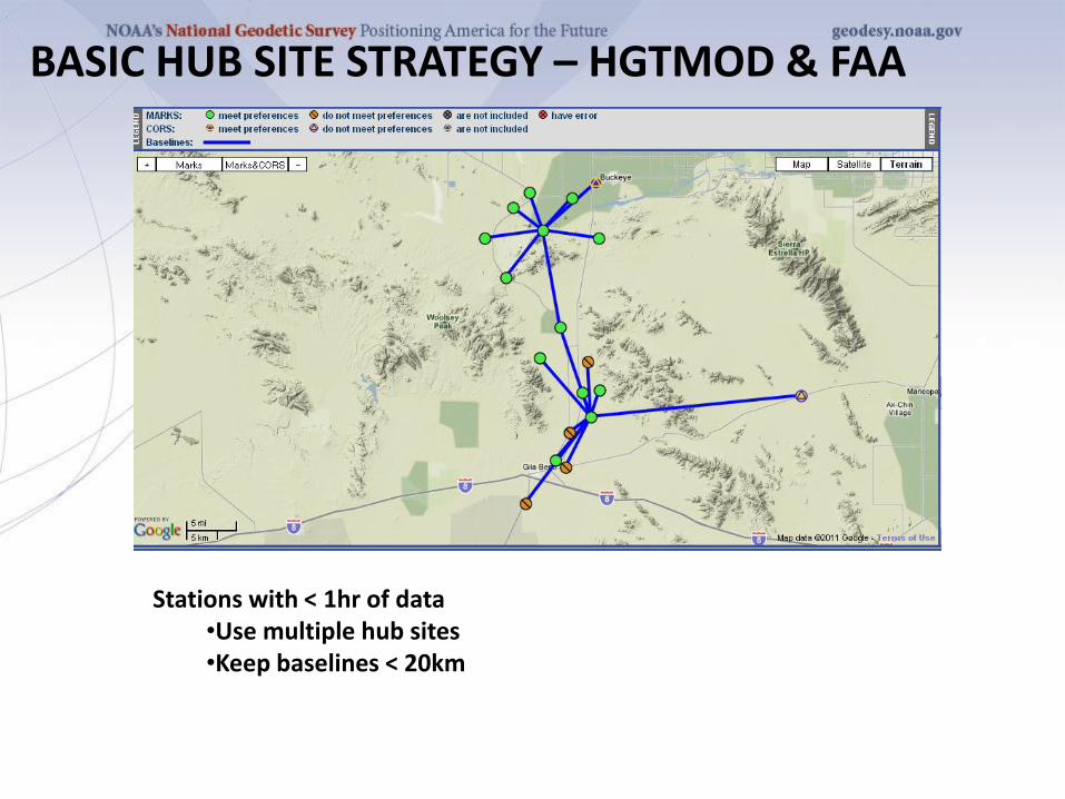
BASIC HUB SITE STRATEGY – HGTMOD & FAA
Stations with < 1hr of data •Use multiple hub sites •Keep baselines < 20km
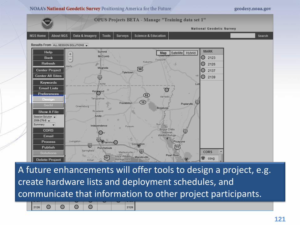
A future enhancements will offer tools to design a project, e.g. create hardware lists and deployment schedules, and communicate that information to other project participants.
121
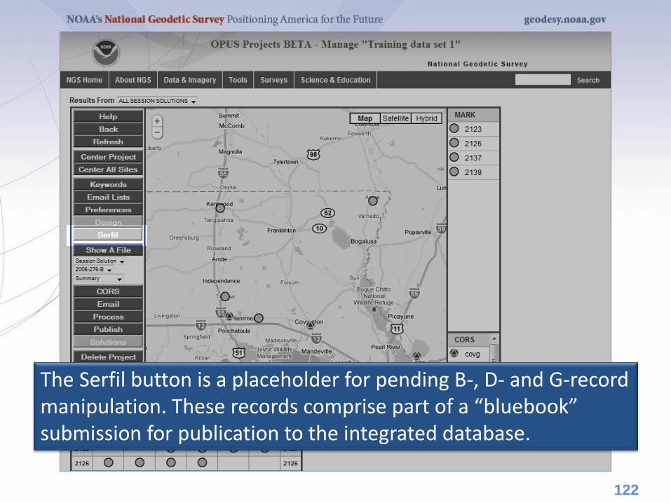
The Serfil button is a placeholder for pending B-, D- and G-record manipulation. These records comprise part of a “bluebook” submission for publication to the integrated database.
122
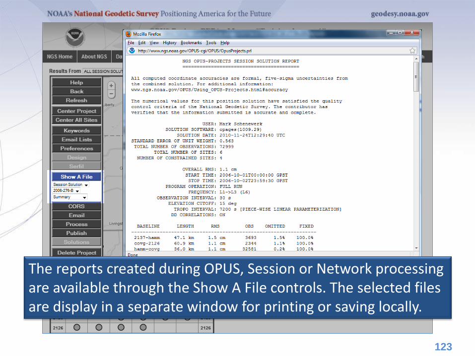
The reports created during OPUS, Session or Network processing are available through the Show A File controls. The selected files are display in a separate window for printing or saving locally.
123

Session solution matrices can be combined and solved creating an adjustment for this project.
124

Using the Publish button, a final network adjustment can be selected, and its results plus the associated mark metadata published.
125
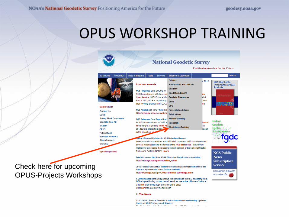
OPUS WORKSHOP TRAINING
Check here for upcoming
OPUS-Projects Workshops


![OPUS - Home | National Geodetic Survey€¦ · · 2017-05-16• The ephemeris used (OPUS will use the best available): ... How do I get help? ... EPHEMERIS: igs14143.eph [precise]](https://static.fdocuments.us/doc/165x107/5b0cb1197f8b9a6a6b8cbd51/opus-home-national-geodetic-survey-the-ephemeris-used-opus-will-use-the.jpg)