The NASA-ISRO SAR Mission: An International Partnership ... · area at 1 ha resolution of staple...
22
The NASA-ISRO SAR Mission: An International Partnership for Science and Society Paul A Rosen Jet Propulsion Laboratory California Institute of Technology Raj Kumar Space Applications Centre, ISRO Paul Siqueira University of Massachusetts, Amherst Feb 17, 2016 Tokyo, Japan
Transcript of The NASA-ISRO SAR Mission: An International Partnership ... · area at 1 ha resolution of staple...
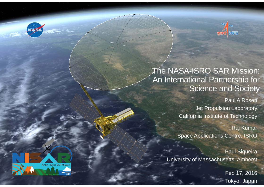
The NASA-ISRO SAR Mission: An International Partnership for
Science and Society Paul A Rosen
Jet Propulsion LaboratoryCalifornia Institute of Technology
Raj KumarSpace Applications Centre, ISRO
Paul SiqueiraUniversity of Massachusetts, Amherst
Feb 17, 2016Tokyo, Japan
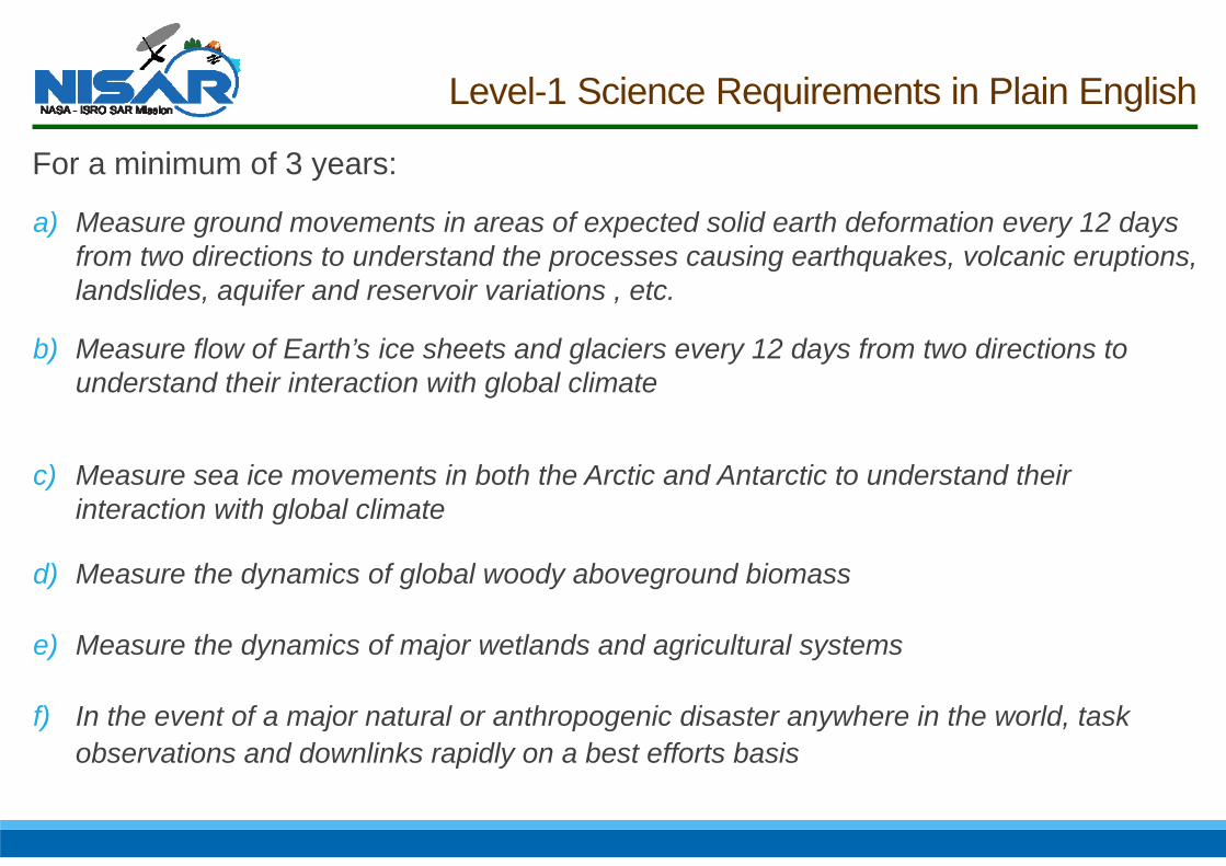
Level-1 Science Requirements in Plain English
For a minimum of 3 years:
a) Measure ground movements in areas of expected solid earth deformation every 12 days from two directions to understand the processes causing earthquakes, volcanic eruptions, landslides, aquifer and reservoir variations , etc.
b) Measure flow of Earth’s ice sheets and glaciers every 12 days from two directions to understand their interaction with global climate
c) Measure sea ice movements in both the Arctic and Antarctic to understand their interaction with global climate
d) Measure the dynamics of global woody aboveground biomass
e) Measure the dynamics of major wetlands and agricultural systems
f) In the event of a major natural or anthropogenic disaster anywhere in the world, task observations and downlinks rapidly on a best efforts basis

NISAR Ecosystems Science Drivers*
• Biomass Estimation
• Disturbance Monitoring
• Inundation Extent
• Agricultural Area Mapping
NISAR Ecosystems Science Drivers*
• Biomass Estimation
• Disturbance Monitoring
• Inundation Extent
• Agricultural Area Mapping
Aboveground woody vegetation biomass annually at the hectare scale (1 ha) to an RMS accuracy of 20 Mg/ha for 80% of areas of biomass less than 100 Mg/ha.
NISAR Ecosystems Science Drivers*
• Biomass Estimation
• Disturbance Monitoring
• Inundation Extent
• Agricultural Area Mapping
NISAR will detect, annually, changes in Vegetation Canopy Cover (VCF) of 0.5 or greater at the hectare scale (1 ha) with a classification accuracy of 80%
NISAR Ecosystems Science Drivers*
• Biomass Estimation
• Disturbance Monitoring
• Inundation Extent
• Agricultural Area Mapping
Inundation extent within inland and coastal wetlands areas at a resolution of 1 hectare every 12 days

NISAR Ecosystems Science Drivers*
• Biomass Estimation
• Disturbance Monitoring
• Inundation Extent
• Agricultural Area Mapping
Classification of active agriculture area at 1 ha resolution of staple crops will be reported every three months.
NISAR Ecosystems Science Drivers*
• Biomass Estimation
• Disturbance Monitoring
• Inundation Extent
• Agricultural Area Mapping
• * Science drivers are different than the many uses of NISAR for Ecosystems Applications
Classification of active agriculture area at 1 ha resolution of staple crops will be reported every three months.
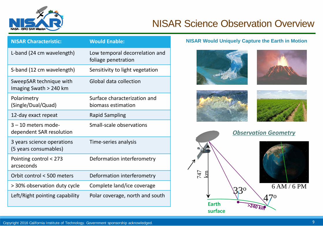
NISAR Science Observation Overview
NISAR Uniquely Captures the Earth in Motion
NISAR Characteristic: Would Enable:
L‐band (24 cm wavelength) Low temporal decorrelation and foliage penetration
S‐band (12 cm wavelength) Sensitivity to light vegetation
SweepSAR technique withImaging Swath > 240 km
Global data collection
Polarimetry (Single/Dual/Quad)
Surface characterization and biomass estimation
12‐day exact repeat Rapid Sampling
3 – 10 meters mode‐dependent SAR resolution
Small‐scale observations
3 years science operations (5 years consumables)
Time‐series analysis
Pointing control < 273arcseconds
Deformation interferometry
Orbit control < 500 meters Deformation interferometry
> 30% observation duty cycle Complete land/ice coverage
Left/Right pointing capability Polar coverage, north and south
NISAR Would Uniquely Capture the Earth in Motion
9
747
kmEarth surface
Observation Geometry
33o47o
6 AM / 6 PM
Copyright 2016 California Institute of Technology. Government sponsorship acknowledged.
NISAR Observation Concept
NISAR* Science Definition Team has adopted an observation strategy to accommodate three major science disciplines with nominally different needs:
•Minimize radar mode contention
•Apply fixed observation plan over each 12-day repeat cycle**
•Cull excessive overlap by thinning observations over the cycle
•Allow for urgent request
10
** To the extent possible
Copyright 2016 California Institute of Technology. Government sponsorship acknowledged.
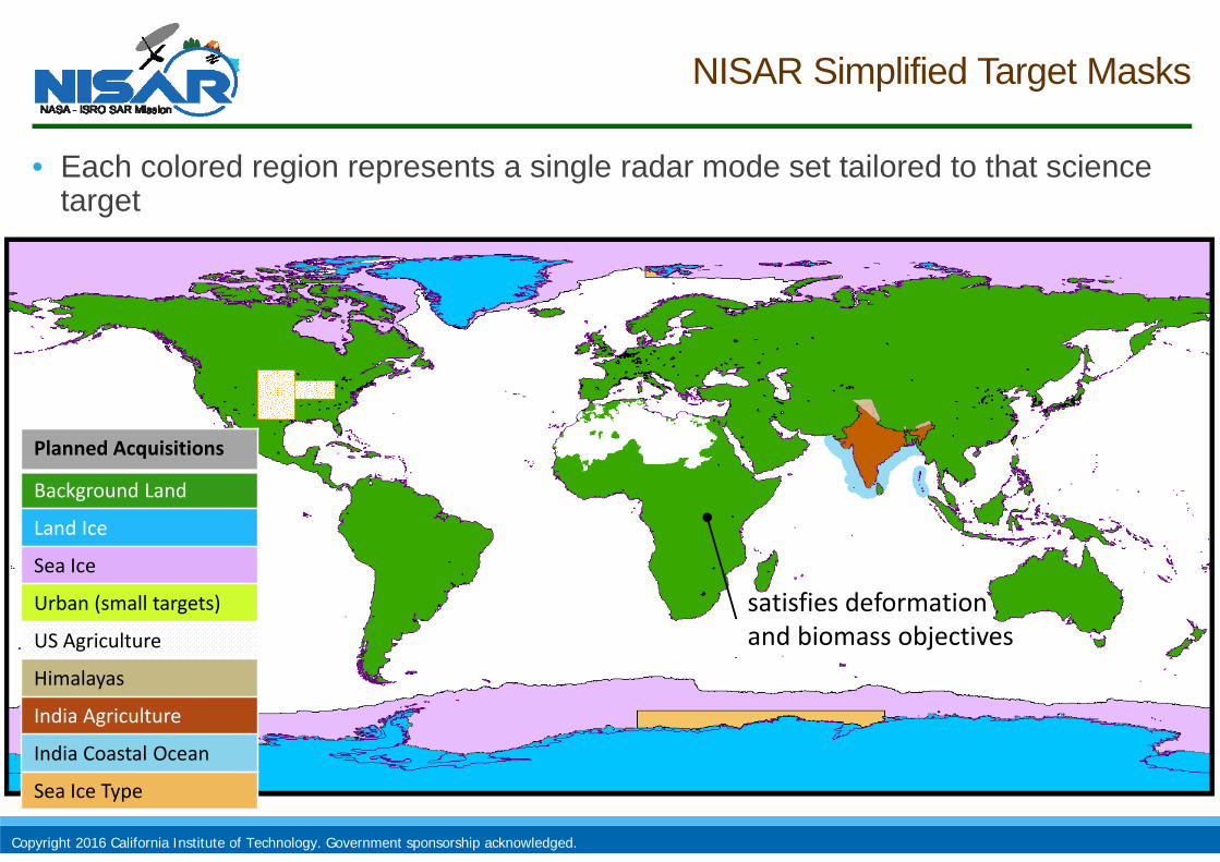
NISAR Simplified Target Masks
• Each colored region represents a single radar mode set tailored to that science target
satisfies deformation and biomass objectives
Planned Acquisitions
Background Land
Land Ice
Sea Ice
Urban (small targets)
US Agriculture
Himalayas
India Agriculture
India Coastal Ocean
Sea Ice Type
Copyright 2016 California Institute of Technology. Government sponsorship acknowledged.
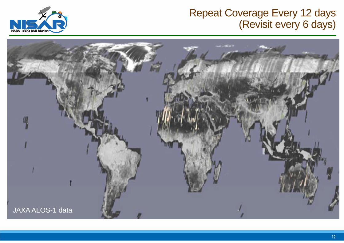
Repeat Coverage Every 12 days(Revisit every 6 days)
12
JAXA ALOS-1 data
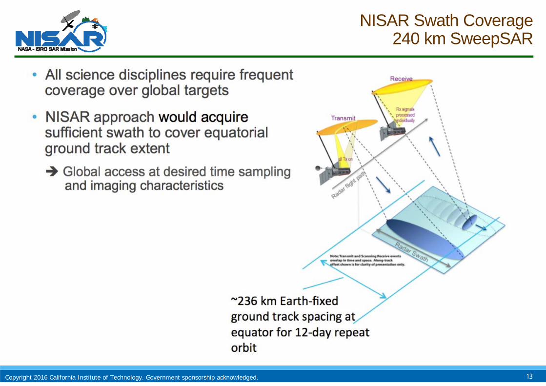
NISAR Swath Coverage240 km SweepSAR
13Copyright 2016 California Institute of Technology. Government sponsorship acknowledged.
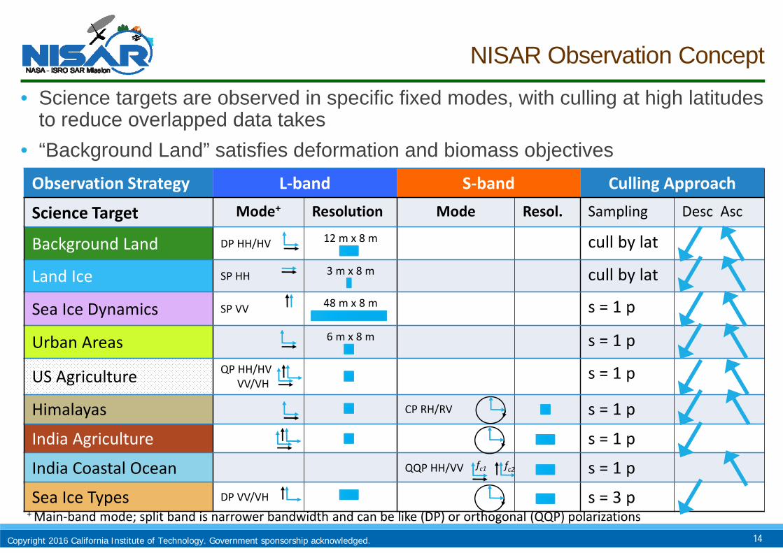
NISAR Observation Concept
• Science targets are observed in specific fixed modes, with culling at high latitudes to reduce overlapped data takes
• “Background Land” satisfies deformation and biomass objectives Observation Strategy L‐band S‐band Culling Approach
Science Target Mode+ Resolution Mode Resol. Sampling Desc Asc
Background Land DP HH/HV 12 m x 8 m cull by lat
Land Ice SP HH 3 m x 8 m cull by lat
Sea Ice Dynamics SP VV 48 m x 8 m s = 1 p
Urban Areas 6 m x 8 m s = 1 p
US Agriculture QP HH/HVVV/VH
s = 1 p
Himalayas CP RH/RV s = 1 p
India Agriculture s = 1 p
India Coastal Ocean QQP HH/VV s = 1 p
Sea Ice Types DP VV/VH s = 3 p
14
fc1 fc2
+ Main‐band mode; split band is narrower bandwidth and can be like (DP) or orthogonal (QQP) polarizations
Copyright 2016 California Institute of Technology. Government sponsorship acknowledged.
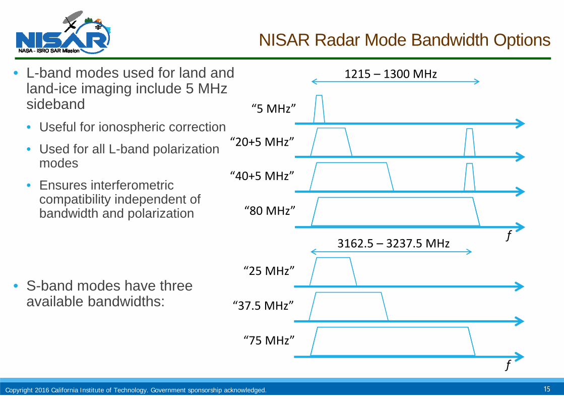
NISAR Radar Mode Bandwidth Options
• L-band modes used for land and land-ice imaging include 5 MHz sideband • Useful for ionospheric correction
• Used for all L-band polarization modes
• Ensures interferometric compatibility independent of bandwidth and polarization
15
“5 MHz”
“20+5 MHz”
“40+5 MHz”
“80 MHz”
1215 – 1300 MHz
f
• S-band modes have three available bandwidths:
“25 MHz”
“37.5 MHz”
“75 MHz”
f
3162.5 – 3237.5 MHz
Copyright 2016 California Institute of Technology. Government sponsorship acknowledged.
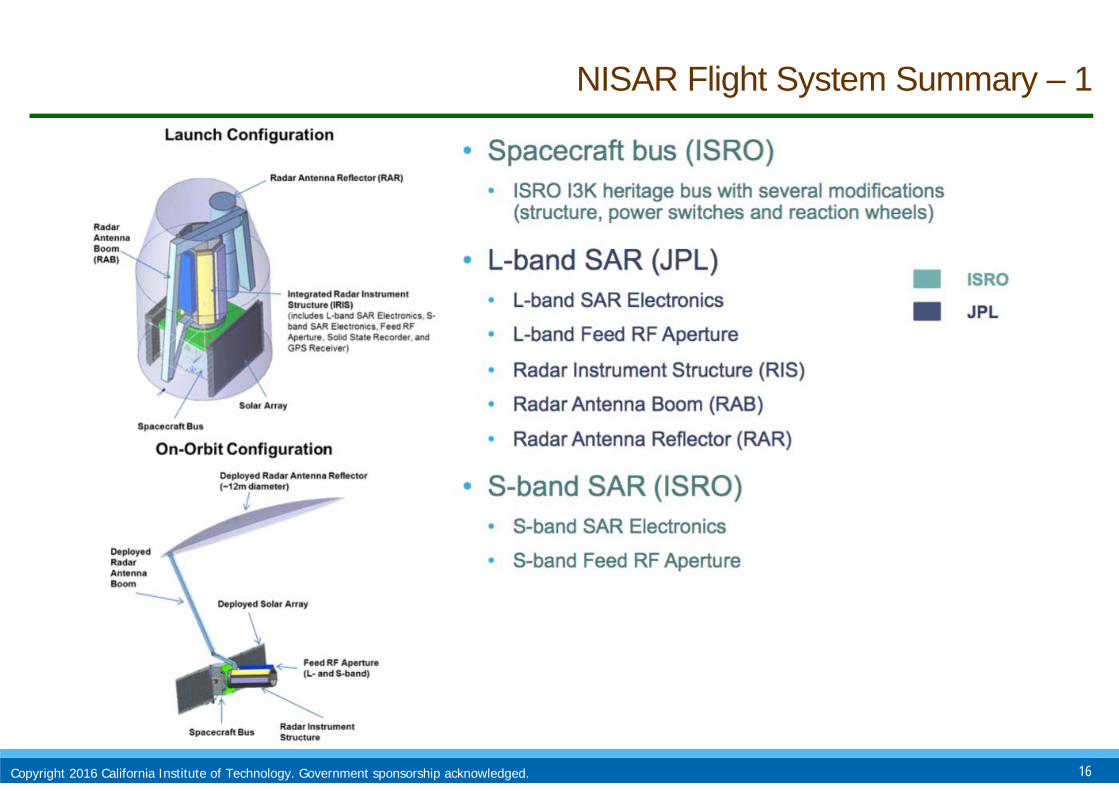
NISAR Flight System Summary – 1
16Copyright 2016 California Institute of Technology. Government sponsorship acknowledged.

NISAR Flight System Summary – 2
17Copyright 2016 California Institute of Technology. Government sponsorship acknowledged.

NISAR Stowed Configuration
18Copyright 2016 California Institute of Technology. Government sponsorship acknowledged.
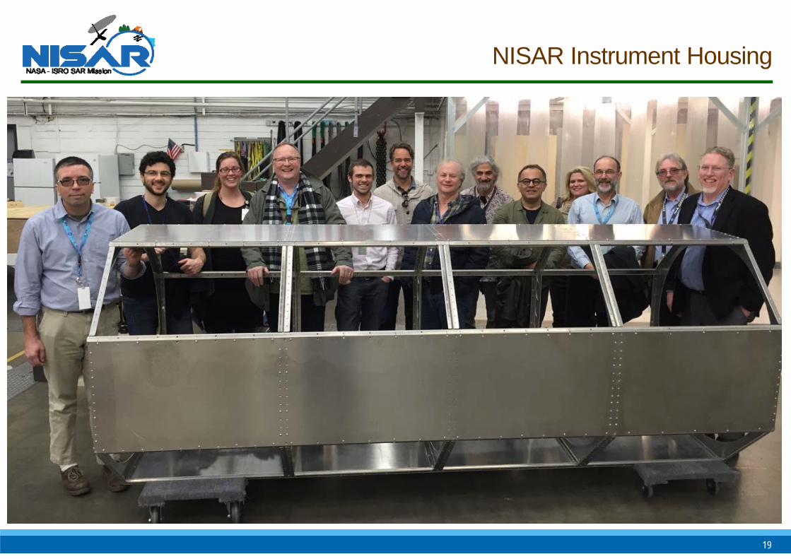
NISAR Instrument Housing
19

• NASA deploying UAVSAR & LVIS in February• ONERA deployed Sethi on Falcon-20
• DLR currently deployed in Gabon (SAR and Tandem-X acquisitions
AfriSAR CAL/VAL Campaign in Tropical Forests
20

21

NISAR Programmatic Status
• Mission Concept Review completed successfully in Oct 2013
• Phase A started May 2014 (Key Decision Point A in Mar 2014)
• Implementing Arrangement between NASA and ISRO signed Sep 2014
• System Requirements Review/Mission Definition Review completed successfully in Dec 2014
• Phase B started Mar 2015 (Key Decision Point B in Feb 2015)
• ASF Selected as Data Node: January 2016
• Science peer review completed April 2016
• BIOMASS/ICESAT-2/GEDI/NISAR Joint Cal/Val Workshop in May 2016
• NASA PDR in June 2016
• NASA Applications workshop held annually (October)
• ISRO Applications workshop held annually (November)
• Launch late 2020
22