
The multilevel systemic consistency of urban planning: … _SYST_CONSISTENC… · The multilevel...
24
The multilevel systemic consistency of urban planning: a tool for the European “cohesion policy” Part I: the planning strategy 1 [A..2007-04 E] XXI AESOP Conference Naples, July 11-15 2007 Track:4-4: Spatial planning and economic development The multilevel systemic consistency of urban planning: a tool for the European “cohesion policy” by Franco Archibugi Planning Studies Centre Rome 00134 Italy, Via Federico Cassitto 110, Tel. (also fax) +39-06-71354200 Email: [email protected] Webpage:www.planningstudies.org Prof. Franco Archibugi Email: [email protected] Web-page: www.francoarchibugi.it Tel.:+39-06-71354004 Rome 00134, Italy,Via Antonio Zanoni 52. Abstract It is inconceivable in the planning theory a relationship between planning decisions at `global' scale and at `local' scale(according numerous recent analysis which postulate and sustain something called `glocal approach' ) unless by running through all the path which links from a systemic viewpoint the `local' to the `global scale and vice-versa. In other terms this relationship must be based on other different intermediary levels that need to be connected between the two scales. In fact any global/local impact has to be valuated through `intermediary' levels and a more close and ‘concatenated’ relationship between each of these intermediary level '. The evaluation method can be applied by the instruments of the well known planning system consistency. The cohesion policy which some time ago the European Union has promoted as general strategic goals of its own existence and task, can be considered a case study in which the planning systemic consistency may constitute a useful, even necessary tool for the achievement of that goal. In this paper one discuss the ways and means through which the socio-economic cohesion and the planning consistency can be a happy occasion of interdependence and interaction, in the filed of urban planning. This is discussed at the light of the findings and results of a European research (within the Framework Programme of Research and Innovation); this research has been carried on in four member countries of EU by the Rome' PlanningStudies Centre in cooperation of six other research institutions in the four countries: France, Germany, Italy and United Kingdom.
Transcript of The multilevel systemic consistency of urban planning: … _SYST_CONSISTENC… · The multilevel...

The multilevel systemic consistency of urban planning: a tool for the European “cohesion policy”
Part I: the planning strategy
1
[A..2007-04 E]
XXI AESOP Conference Naples, July 11-15 2007
Track:4-4: Spatial planning and economic development
The multilevel systemic consistency of urban planning:
a tool for the European “cohesion policy”
by Franco Archibugi
Planning Studies Centre Rome 00134 Italy, Via Federico Cassitto 110, Tel. (also fax) +39-06-71354200 Email: [email protected] Webpage:www.planningstudies.org Prof. Franco Archibugi Email: [email protected] Web-page: www.francoarchibugi.it Tel.:+39-06-71354004 Rome 00134, Italy,Via Antonio Zanoni 52.
Abstract
It is inconceivable in the planning theory a relationship between planning decisions at
`global' scale and at `local' scale(according numerous recent analysis which postulate and sustain something called `glocal approach' ) unless by running through all the path which links from a systemic viewpoint the `local' to the `global scale and vice-versa. In other terms this relationship must be based on other different intermediary levels that need to be connected between the two scales. In fact any global/local impact has to be valuated through `intermediary' levels and a more close and ‘concatenated’ relationship between each of these intermediary level '. The evaluation method can be applied by the instruments of the well known planning system consistency.
The cohesion policy which some time ago the European Union has promoted as general strategic goals of its own existence and task, can be considered a case study in which the planning systemic consistency may constitute a useful, even necessary tool for the achievement of that goal. In this paper one discuss the ways and means through which the socio-economic cohesion and the planning consistency can be a happy occasion of interdependence and interaction, in the filed of urban planning. This is discussed at the light of the findings and results of a European research (within the Framework Programme of Research and Innovation); this research has been carried on in four member countries of EU by the Rome' PlanningStudies Centre in cooperation of six other research institutions in the four countries: France, Germany, Italy and United Kingdom.

The multilevel systemic consistency of urban planning: a tool for the European “cohesion policy”
Part I: the planning strategy
2
The multilevel systemic consistency of urban planning: a tool for the European ‘cohesion policy’
Part I
The planning strategy
Contents Abstract...................................................................................................................1 Part I The Planning Strategy 3 1. Introduction........................................................................................................3 1.1 Spatial planning at a multi-national scale ..........................................................3 1.2 The case of the ESDP and its limitations...........................................................5 1.3 The critical foundations of a selected lexicon ...................................................8 2. Towards research into a multinational city effect of reference. ..................10 2.1 The set of urban indicators...............................................................................11 2.2. A reference taxonomy for the ‘urban system’s model....................................12 2.3 The traditional pattern......................................................................................12 3. A typology according the planning strategy..................................................18 3.1 An essential typology of strategic role ............................................................18 3.2 Typology of pattern according to plan’s strategy ............................................21 3.3 .The strategy as interdependency between ‘urban systems’ ............................21 References of the Part I .......................................................................................22

The multilevel systemic consistency of urban planning: a tool for the European “cohesion policy”
Part I: the planning strategy
3
Part I The Planning Strategy 1. Introduction
1.1 Spatial planning at a multi-national scale
Once upon a time, spatial planning was born in the bed of town planning. It was, essentially, a physical form of planning. Town plans or territorial plans, called “masterplans”, have always been essentially physical, in the sense that they have occupied themselves with the design of a physical use of land-space or (which means the same) with the design of the use of physical land-space (if we start with the concept that the “space” is only a physical element).
However, since some time ago – maybe we can agree that this has been happening since the end of World War Two – the traditional town planners have extended their vision; it is not possible – they have said – to determine a “physical spatial” optimum, if not in relation to non-spatial (socio-economic-institutional) conditions and constraints1.
This provoked (as it should have) a great change in the theory and the practice of spatial planning. In fact, from it has been derived a vast extent of researches, the main ones having been the regional economics (or more generally, “the regional science”), which have explored, largely, the inter-relations between the traditional physical-spatial planning with the non-spatial socio-economic aspects; and “the planning theory”, which covered the inter-relations between traditional physical spatial planning and the non-spatial institutional aspects (like procedural aspects, decision theory, theory and sociology of communications, theory and philosophy of law, etc.).
But old habits die hard. The systemic integration between spatial and non- spatial phenomena has not quite been assimilated in the forma mentis of the land-spatial planning scholars. The extensions of vision on the part of the traditional town planners, to which we have referred, remained in the state of…mere extensions. They didn’t give way to a real meta-disciplinary reconsideration, to a new generalist approach to planning, which come not only – as is the case, for instance, of our planning school associations – from the ancient planning schools intended for the most as town planning schools, which are mostly located in the traditional schools of architecture as urban and regional departments.2 The core of these extensions is always town planning, which is only with difficulty related to the other planning levels, the national and multi-national ones, which are by now so influential on local life.3
1 I wish remember some old stimulations on the subject: first, in the magistral way, from Walter Isard , (the ‘father’ of the Regional Science) (1969; see also 1998); and in the circle of town-planners, from M.M.Webber,(1964) and R.A.Bird (1968) and more recently from P.Hall (1996). 2 In some universities (for instance, in the University of South California at Los Angeles) the traditional department of urban and regional planning has merged with the department of public administration. This is the right way to renew the approach! 3 It seems to me dutiful, however, to remark, within these observations on the “systemic shortcomings” of the above-mentioned “extensions” on the part of the town-planners, that similar

The multilevel systemic consistency of urban planning: a tool for the European “cohesion policy”
Part I: the planning strategy
4
Attempting to respond to that imperative of systemic vision, the planning schools – even while remaining in their own beds – have been spread in many different directions. Among these directions has been the application of physical planning on different scales, including national and multi-national scales (and I think that the pressures, in the time in which we live, of the phenomenon of so-called globalisation, are inducing town planners to bring their attention also to the global scale).4
In the European area (which is the area in which I live, and which I know better), there have been many attempts of physical planning at the national scale. Although, I repeat, the core of these attempts has always been the land use, they have tried to be open also to socio-economic considerations of a “national” kind. This, in spite of the fact that none of them has been conceived in terms of strict coordination with national socio-economic plans, where existent. Nor, therefore, have these attempts ever achieved the character of components incorporated in national initiatives of integrated planning, as spatial dimensions of them.
In the European area, people have also even had a very important example of physical town planning officially brought to the multi-national scale: The European Spatial Development Perspective (ESDP)5. This event, the “construction” of these perspectives (which have never been conceived as a master plan) can assume an indicative and significant value, very important for
shortcomings have been registered within the other disciplinary approaches which should have contributed (and should still be contributing), to an integrative and complete form of planning, and to its teaching. In any case, the traditional planning schools have been more open to the other different approaches than the other disciplinary schools such as economics, sociology, administration and management sciences, etc. This argument, which is outside the scope of this paper, has been the object of many of my other writings (Archibugi, 1980;1992; 1994, 1995a, 2003). It has also been the subject of a first authentically interdisciplinary conference in 1992 (Palermo: the First World Conference of the Planning Science on the theme of Planning Techniques and Institutions), promoted by the Planning Studies Centre and the sponsorship of the UNESCO, the United Nations University and the European University Institute) We can say that this conference has been so interdisciplinary - with the attendance of many scholars coming from so many different strands - that it has failed to get continuity for further work or for the construction of a network for the reconstruction of an integrative (spatial and non-spatial) methodology of planning. 4 This scale has already been approached by many town planners, especially those of a “Marxist” background, who have interpreted and described the evolution of the concentration of capitalist system interests at the world-wide scale as the key factor within which an unbalanced growth of power has developed between some great cities, as centers of world power, to the detriment of the other cities that are suffering an ongoing impoverishment of their urban values. I refer to some others (with many followers) like David Harvey (1973, 1985, 2003, 2006), Saskia Sassen (1994, 1996, 2002) and many others. This vision (or paradigm?) in my opinion contradicts another trend of scholars of the urban evolution, which on the contrary has shone a light on how the spatial impact of the modern technology (especially the ITC) favours the diffusion of the urban values in the territory, a phenomenon that has sometimes been called “de-urbanisation” or even “counter-urbanisation” (See for instance Berry (1980), Kunzman and Wegener (1991)). But, in these visions, it is difficult to distinguish the effects from their interpretation or “reading keys” and therefore, I think, that we must consider them very questionable. Anyway, they are not the subject of this paper. 5 European Commission, 1997. See also by the European Commission the Reports (1999a, 1999b, 2000, 2001).

The multilevel systemic consistency of urban planning: a tool for the European “cohesion policy”
Part I: the planning strategy
5
European policy as a whole and, for the national land use policies. It is a significant event which deserves the greatest consideration.
However, the object of my paper is another: it is not to enlighten regarding the ESDP’s merits and its progressive political meaning. It is, on the contrary, to enlighten regarding its defects. Starting from the ascertainment that the contents of the ESDP, and the way with which people have arrived at its definition, is that of the traditional way to consider physical planning, even on the other, more usual, scales (the urban and the regional ones), my opinion is that this character put it in the condition of: (a) to be poorly useful to the implementation of its strategic objectives (the socio-economic cohesion); (b) to be based on evaluation presuppositions which are very unclear and fallacious enough; (c) to delay instead of hastening an experience of unitary and integrative approach to planning.
1.2 The case of the ESDP and its limitations.
I will not judge the experience that I have taken as an example, the ESDP, from the point of view of its political effectiveness, which has been the angle from which it has, for the most part, already been assessed.6 I intend to assess it from the point of view of its “scientific” effectiveness. In effect, I think that any kind of plan – even the plans that don’t intend to be executive or master plans, but only indicative and propositional in order to be taken into account in the heap of general political decisions - cannot avoid knowing its impact, even with other dimensions incorporated in the planning itself: the socio-economic dimension, the sectorial one, the institutional one. All this on the assumption – not always justified – that the physical spatial dimension includes (or better, blends) with itself, even the full consideration of the effects by any kind of socio-economic decision on the physical environment.
The scarce familiarity of the “constructors” of the ESDP with the concept and the method of planning multi-dimensionality is rendered evident particularly in the scarcity of references to a shared concept of cities, whether in the official documents through which people arrived at the ESDP or in the preparatory studies that the European Commission has developed in the aim of coming to the elaboration of such documents.
The European Economic Community (today Union) has, for since time, promoted a policy of “social and economic cohesion” among the member countries.7 This implies also that we should start from the shared definition of the 6 The ESDP has been object in the last few years of a great quantity of analysis and debate. And it has had the honour (I am not sure if deserved), of much interest from the most influential man among the planning theorists, Andreas Faludi. Leaving aside a wealthy bibliography of comments and analysis of the ESDP made by Faludi in his papers (some forty of them), his historical critical reconstruction of the process of making this important political document of the European authorities (written in cooperation with Bas Waterhout) (2002), will remain a basic source for anybody wanting to talk in the future about ESDP. 7 It is in the Single European Act of 1988 that this policy began, with further little steps in the Treaty of Maastricht (1991), and those of Amsterdam and Nice (1997 and 2000).

The multilevel systemic consistency of urban planning: a tool for the European “cohesion policy”
Part I: the planning strategy
6
basic criteria with which one evaluates such “cohesion” (values, methods, measures).
In the “socio and economic cohesion” we can flow together all the decisions which define the non-spatial, i.e. which are not aimed at the physical-spatial use of the territory: social welfare, economic development, quality of life, quality of work, quality of services, security, technologies, criminality, etc. It is difficult to sustain that something of the decisions or actions at which is aimed such a policy of “social and economic cohesion” could not have a relationship with the physical spatial land use of the territory and, vice versa, that every decision aimed at a better use of territory could not have a relationship, and an impact, on the multiple factors of the social cohesion. Nevertheless, in the process which has led to the ESDP, we are very far from the proposal of “perspective” that could be the result of a full integration of two points of view.
In some official documents of the European Economic Commission, “territorial cohesion” is spoken of as a synonym of spatial planning.8 We are not going much more beyond vague expressions, no further specified, in order to avoid their use in different concepts. But what are the points of real contact between the territorial policy and action with the social and economic cohesion policy? Not one of the historical ESDP documents tells us.
In my opinion, an important (perhaps the most important) point of the suture or pivot, between the two policies, is the city, where are developed the majority of those things that concern the individual and the social welfare of the people. At least, as long as mankind does not lose its stationary state of living (and doesn’t become again nomadic and ubiquitous), the city – as a concept and as reality – will remain (against all its great transformations) the place in which are materialised the greatest number of the interpersonal relations for the majority of the population. It is also the place in which the worries of the physical planner and of the socio-economic one, are unified and are integrated. The place in which the physical welfare and the socio-economic one are implemented.9
Moreover, the city is also the place in which the greatest risks of modern life are terribly homologising themselves, instead of differentiating themselves according to geography, history, the climate and economic development: pollution of every kind (atmospheric, water, air, waste, noise) health organisation, traffic, various kinds of congestion, accessibility to services (today ever more personal services), etc..
A socio-economical and territorial cohesion between countries and national societies, cannot but start from a greater cohesion intending and harmonising the concept of the city itself, its requirements, that which optimizes the services and 8 For instance, the term has been introduced by the Amsterdam treaty. 9 A good deal of the works by Peter Hall ( for instance, 1995a and 1995b), 1999, are oriented in this direction. A rare exemple in planning literature of research towards a real integration of physical and socio-economic approach is the work of Phil Cooke (1984), work that go far beyond what I called - above - ‘extension’ of mere physical planning, and trying a true effort in a ‘meta-disciplinary’ approach focused – however – in a still undefined ‘regional’ ambit and the factors of its ‘innovation’. (about which he became a well-known scholar). The Cooke’s true meta-disciplinary approach has been perhaps the factor of his regrettable lack of influence in subsequent planning theorist’s literature.

The multilevel systemic consistency of urban planning: a tool for the European “cohesion policy”
Part I: the planning strategy
7
the quality of life. This is something that has value for any kind of multinational political approach.
In a multinational approach, this is not conceivable without a hypothesis of multinational policy. Neither is a multinational policy conceivable without any kind of form (from the weakest to the strongest) of supra-national authority. Also inconceivable is an authority which intends to get the strategic objective of a greatest socio-economic cohesion, but does not establish some references, some standards, some targets and instrumental objectives, which could be commonly accepted. From the other end, if such authorities have some sustainable powers for the achievement of a greatest cohesion (for instance, the financial means, like the structural funds, in the case of the ESDP), it cannot but have a homogenous method for the measurement of the success of its action, if such funds are spent well or poorly, if they are addressed to obtain results adequate for the cost.
If all this must be pursued, it is not reasonable to have a method of measuring that is incapable of comparing situations that are analogous and comparable; otherwise, it means comparing objects that are incomparable (say, ‘cities’). The demographic and territorial requirements of cities, in order to compare their character, for instance the needs or the welfare levels, must be equal. Otherwise the comparison is foolish and fallacious, and leads to evaluations and decisions which are totally misleading.
Regarding this need and this imperative, we find no trace in all the paths which have led to the ESDP in Europe. I believe, on the contrary, that it is an essential requirement for every multi-national approach of planning (meants of course, as ‘integrative’ socio-economic planning).
Naturally, the concept of city, and of what produces the city effect, or cityness has been through history in a permanent transformation; probably, in recent times it has been more rapid, and in the future it will be even more so. However, is it possible to avoid it if we wish to have an idea about what to do in order to improve the urban condition and to render it more cohesive at a multi-national level? A good deal of the political – and, alas, also the academic – speeches that people make on this subject are pervaded with implicit and self-referential statements, and when people try to make their references explicit, the speeches are dissolved in a series of arcane, uncontrollable notions, that are not measurable. This turns the town planning discourse into nothing more than a pretty chat. The contribution that spatial or town planning must make to the political decision is that of providing a homogenous reference framework which could allow adequate evaluation and rational decisions; and, I insist, it should do so independently from the degree of enforcement that the public authorities of the superior level can, as a matter of choice or a result of circumstances, exercise on the public authorities of inferior level.
The multilevel systemic consistency of urban planning: a tool for the European “cohesion policy”
Part I: the planning strategy
8
1.3 The critical foundations of a selected lexicon From what we have said can be derived the reasons for a preferred lexicon,
which deserves to be rapidly outlined, in order to avoid the dangerous subjective use of the terms.
In my opinion, when we (planners) use the word “planning”, we should conceive it without adjectives. If we should accept some adjectives, they should be only the procedural and / or methodological ones - such as integrated, systemic, unified, strategic, comprehensive and others - which are not true substantive attributes, because the concept that they express is already included in the word that they should be illustrating. These are different from the adjectives that add something substantive to the above nude and crude concept of planning (as we say: physical, urban or spatial planning, versus economic, environmental, social, transport, tourism, etc. planning). When we say that the attribute is already included in the concept – in our case, the concept of planning – it means that if the attribute would fail, the concept itself would also fail; in our case, if planning would not be together, integrated, systemic, unified, etc, it would no longer be a real true planning, and it would not deserve to be called such.
From all this it can be derived that spatial or territorial planning (risen from the logical ashes of the physical territorial one, which is on the contrary still thriving on the professional level of the city architects), is a delimitation that is damaging to the concept of planning, because it adds to it something specific, and risks taking away from it the capacity to be effective, because it is shorn of functional, systemic relationships with many other non-spatial factors that, if ignored, influence strongly the result.10 How many physical spatial plans, apparently rational, fail only because they have not taken into account the economic financial constraints or the availability of the stake holders for which they have been conceived? Is it not almost all of them?11
10 Here is one of the basic reasons for the failure of spatial planning of professional origin, where it has not yet penetrated the critical spirit of the planning theory, despite the fact that even this planning theory has not been liberated from its own “spatial” origins. In my opinion, the reasons for the crisis of planning must be sought in the missed acquisition of a new meta-disciplinary or neo-disciplinary identity of planning. [I have developed this concept in my work Planning Theory: from the politological debate to the methodological reconstruction (Italian edition 2003, English edition forthcoming.)] In a congress of planning schools (tout court) such as that in which we are, we should find ourselves in an environment free from the spatial and physical-urban influence, but this is not the case. On the contrary, I have the strong feeling that here the spatial bias predominates. 11 I cannot liberate my head from the idea that the ESDP conclusions to which I refer myself are destined to have little impact in positive terms on the policies, or at least they are no more than a reflection ex ante of trends that would take place even without the ESDP. (This would besides largely justify the victory, achieved in the long period of elaboration, that has imposed on the title of the ESDP the word “development” against those that would prefer in its place the word “plan”.) A nice immersion in the language confusion about the land use policies in the various European countries, is the reading of the European Commission’s document “On the Systems and Policies of Spatial Planning” (European Commission, 1997)

The multilevel systemic consistency of urban planning: a tool for the European “cohesion policy”
Part I: the planning strategy
9
Even regarding the concept of “city” we need finally to arrive at a univocal concept, just to avoid misunderstanding. Here the enterprise seems to me easier because for some time people have identified the city12 in a set of functions which concerns the welfare of its inhabitants (of course, changing over time, but not for this reason indefinable). At the same time, the fact that we have given to this concept a normative flavour – the achievement of a standard of urban welfare coming from the presence of those functions – has simplified its concept in respect of all the infinite attributions that the geographical descriptive analysis has believed to introduce. In the face of the numerous variables, urban patterns and conditions, the city concept problem is reduced to the definition and quantification of a theoretical model of city.13
Thus, this model became an unavoidable element of evaluation and measurement for a policy of urban welfare. In fact, it is difficult to conceive of an urban policy and planning without a reference to this model, which indicates the priorities of the improving interventions.
The terms most used to qualify this concept of city in the most modern way are “urban system”, “optimal city”, “sustainable city”, “cityness”, “city effect”, “optimal urban centrality” and a legion of other terms. Even here, it should be clear that – taking a distance from the descriptivist obsession – all these terms mean the same thing, the same concept: a set of functions for the citizen, - optimised, given the circumstances; a set of functions which give to the citizen the sensation of living in a complete city, in a territorial or spatial system, in which it is possible to evaluate and measure (within the limits concerning the functionality of the spatial level in question and in comparison with those of other systems of its own level) merits and defects, advantages and disadvantages, presence or shortcomings of functions, through appropriate indicators.
Between all those terms, maybe the most “neutral” and more adherent to a modern concept is that of “urban system”.14 12 Beginning from the celebrated ‘school of Chicago’ – essentially of urban sociologists – in the ‘20 and ’30 of the last century. 13 Of course a city conceived with the latest characters of the ‘modern’ city (P.Hall, 1997 and 1999, J.Rautsi 1993). 14 The term “city”, on the contrary, immediately stimulates a historical descriptive casuistics, and it risks losing us in the dimensional lexicons dear to the geographers – from the micropolis to the megalopolis – which have always had little meaning of substance. The discontinuous use of these terms, although I declared that they have the same meaning, (at least in their normative flavor), can be sometimes motivated by the need to accentuate – in determined circumstances of environment or of argument – some shades of meaning which we need to employ. This is the case, for instance, of the title of this paper, in which I have preferred to use the term (not the concept that it is the same) “city effect” rather than “urban system”, because it seemed to me immediately more perceptive of the specific political content that I wished to give to the concept. The term “urban system” has been used in literature with several other meanings, among them even meanings different from the use that I would make here. [For a general glance at the several uses made, within a “systemist” conception, I would have nothing better than to refer the reader to some collective works by C. Sergio Bertuglia (1987, 1990, 1994, 1998)] Therefore, its use would require a long reconsideration of the term that I do not here have the time to make. However, in presenting, in the following sections, the results of a multi-national research on the urban future in Europe, the research participants agreed to maintain the term “urban system”, used with the same meaning as “urban effect”, normatively meant, in the same research, because there they had the

The multilevel systemic consistency of urban planning: a tool for the European “cohesion policy”
Part I: the planning strategy
10
The definition of such an urban model (or system) of reference, beginning from its territorial or demographic dimensions, is an indispensable or unavoidable premise (in order to make sense) of an urban multinational policy (also national or regional ones).
2. Towards research into a multinational city effect of reference.
Introducing this substantive vision of town planning at a multinational scale, the intent of this paper is to present the findings of a research implemented – exactly – at a multinational scale, which was just aimed at providing a frame of homogenous references for the elaboration of a unitary and integrated notion (or concept) of urban systems (or “city effect” or “cityness”). First of all, it is worth saying that this research, even if addressed to the improvement of the spatial planning procedures in the European Union, and even if funded by the framework program of research and development of the union that is periodically promoted, has been applied only to four countries of the union: France, Germany, Italy and the UK.15
The pivots of the research are simply two: 1. The identification of a set of urban indicators capable of helping to build a
model of the urban system that is acceptable at the multinational scale. 2. The identification of a territorial distribution – on a concrete national territory
of each of the four countries – of urban systems capable of meeting the requirements of the formulated model of the urban system.
Such distribution is presented as a proposal to the national government (and at
the same time to the regional and local government), concerning an organisation by the urban system of all policies having a spatial dimension.
On these two pivots has turned all of the research approach and process. 16 The (theoretical) concept of the urban system (alias “city effect” or “cityness”)
has strongly conditioned the research on the factors of urban welfare, giving them a reasonable quantitative proportion.
time to relate its correct meaning, which pervades all the research. (For more arguments, see Archibugi, 1995a e b) 15 The project considered a further extension of the research to other significant countries of the European Union, but, although this was not done, the research authors still think that the urban system model and the urban indicators that have been found with the research can have a validity for a good part of the other European countries and also non-European countries in the same advanced state of development. In Appendix no.2 of this paper there is the schedule of the entire staff of six European Research Institutes that have cooperated in the research (under the guidelines of the Planning Study Centre of Rome, which elaborated the research project approved by the tender by the European Commission). 16 This research has been published in a synthetic edition(and limited copies) by the Planning Studies Centre, under the editorship of Franco Archibugi, with the title The Future of the Urban Quality in Europe: Towards a New Concept and Strategy of “European Urban System” (Rome 2003, second edition). In the remainder of this paper, quotation of the research will be made with reference to this publication.

The multilevel systemic consistency of urban planning: a tool for the European “cohesion policy”
Part I: the planning strategy
11
At the same time, the exploration of the situation in some selected cities, by means of the surveying of some indicators of state, on the list of those considered significant to give substance to the urban system concept, allowed us to give to the urban systems some reference spatial objectives.
The reference to such objectives approximately quantified, has helped the researchers in the formulation of the proposals of territorial urban aggregation, on which to articulate later the territorial and distributional policies in every country.
Thus the urban systems designed have become (where possible) the statistical surveying units, appropriate to the chosen set of indicators. Any other statistical units have been considered misleading and fallacious. However, the chosen indicators have become the instruments of control of the consistency of the territorial areas to become the “urban system of reference” for a national policy of interventions. With respect to the logic adopted, any other territorial policy of intervention becomes arbitrary, disordered and chaotic, not conscious of the real effect achievable and achieved; certainly, not deserving of the qualification of rational plan.
Posed in these terms, the setting up of the research gave the following results. 2.1 The set of urban indicators
The research has tried to identify what phenomena and urban services could
guarantee an appropriate city effect.17 Agreed on such lists, the researchers have explored – each with the means
available to him – in the chosen sample cities, 18 which could be the functional level of access and fruition to the phenomena and service of the list.
From this enquiry19 a framework has been born for every country, from which the researchers have “negotiated” among themselves a frame valid at a multi-national scale.20
17 Table 1 [6.2 in the research text already indicated, PSC, 2003] shows the list of the “central” indicators on which the research turns, after a vast analytical procedure and debate on them. (See chapter six of research in the quoted volume). 18 There were twenty sample cities (five for each of the four countries investigated). The selection of the sample cities has been made as follows: Two cities chosen from among the “large” cities, (one with a more “developed” economic
context and the other less developed economically). Two cities chosen to represent “medium and small-sized cities”,(one with a more “developed”
economic context and the other less developed economically). One city with a strong individual character. The choice criteria of the cities recommended to the researchers has been: The representation of certain general factors in common to all the centralities (such as city
size or other factors of differing geography). The diversity of lifestyles. The exclusion of those cities with specific factors that would create a distortion of the sought-
after theoretical centrality (such as the capital city, or administrative centre of this type. 19 In the investigation the national researchers have searched, as far as possible, to consider (and therefore to draw) column A: state indicators; B: standards, needs and lag indicators; C: target and

The multilevel systemic consistency of urban planning: a tool for the European “cohesion policy”
Part I: the planning strategy
12
In the research process, the negotiation among researchers has simulated a political institutional process. Obviously, the simulation has been largely easier than that which could be in a real political institutional process. However, the modalities of the stage could be not very different, and their clearness (in a technical level) could not but facilitate the real process.
2.2. A reference taxonomy for the ‘urban system’s model In formulating a theoretical model of reference of urban systems,21 one must
face the problem of the different types (or patterns) of city. In fact, we can ask ourselves: does the urban pattern have an impact on the possible urban policy that we have to identify at the multi-national scale (in the end to obtain a greater social and economic cohesion, the main objective of the European Union)?
The conclusion to which we have arrived is that the urban pattern has no direct impact on the socio-economic cohesion and on the citizens’ welfare. However, the organised existence of true ‘urban systems’ (city effect, cityness, etc.) does have such direct impact. In fact, that existence is its condition. And, since the urban pattern can often have a strong influence on the application itself of an urban systems policy, aimed at their creation and at their territorial balance, then the urban pattern can have an indirect influence on that cohesion and that welfare. So, its impact on the socio-economic cohesion can be defined as indirect. For this reason, within the logic and policy of the urban system it is advisable to include also the consideration of the urban patterns.
For this reason also in the research it was first tried to build a sort of possible taxonomy of urban system patterns, to help not only in the classification ex post of the urban system both identified or created, but also to help ex ante in the identification of possible optimal configuration of such systems and of the policies aimed at their organisation.
2.3 The traditional pattern A first, very simplified taxonomy has been drawn – in the research – by a very
traditional pattern of spatial characters.22
goal indicators, D: input indicators; E: process (throughput) indicators (efficiency, effectiveness, etc.); F: output (achievement) indicators. 20 In Table 2 [10.4 in the quoted publication] are shown the indicators both of city effect and overloading considered acceptable by the team of researchers at the conclusion of the exploration of situation in the twenty cities investigated. For further information on the modalities of the research on the indicators, and about the negotiations related to them, see chapter from 7 to 10 of the quoted volume. 21 About such models, see chapters 11, 12 & 13 of the research volume (PSC, 2003). 22 Among different classifications, I have chosen the most simple. It has been drawn by an old didactic work (Archibugi, 1980) and improved more recently I other work (Archibugi(1995a) to which I refer the reader for wider discussion.

The multilevel systemic consistency of urban planning: a tool for the European “cohesion policy”
Part I: the planning strategy
13
First, the research has classified and articulated the diversity and multiplicity of the urban systems model, with regard to
a. Structure b. Form (or morphology) c. Quality (obviously urban)
a. Structure The word “structure” is used here only to mean the nuclear physical structure
of the built-up area of settlements (thus, the word could be considered inadequate, but for the moment, nothing better has been found.) The diversities in structure can be reduced to three fundamental types:
1. the concentric (or mono-concentric) structure23 2. the polycentric structure24 3. the diffuse structure25 It is obvious that the distinction suggested is applied to structures (urban
systems) of an equivalent level or territorial scale (in our case, the “urban system” distinguished by the common requirements and structural components previously discussed). At different territorial levels or scales, the structures cannot be compared, and probably change in type: a concentric structure could become polycentric, a polycentric one could become diffuse, a diffuse one may show concentric features.
This is why one structure cannot be “preferred” to another, unless there is a strict correspondence with historical, geographical and – above all – functional circumstances in which they are manifest, or to which they can be applied.26
23 The concentric structure is based on settlements with a concentrated nucleus, which is extended to a greater, or lesser extent, intensity and density. It is a structure whose compact mass has a strong capacity for centripetal gravitation up to the level of saturation, and centrifugal gravitation beyond that. 24 The polycentric structure is based on the presence of several (more or less concentric) nuclei, of which none is so clearly superior to another in gravitational force as to make the latter hierarchically inferior. Rather, these nuclei maintain a certain interaction between them, in terms of the reciprocal inter-action of functions. 25 The diffuse structure is based on the presence of a large number of nuclei of different sizes and hierarchical levels, none of which is so important as to have an exclusive gravitational force on its territory. 26 More information and evaluations on the urban structure can be found in the work on “Theory of Urbanistics” already quoted (Archibugi 1995a).

The multilevel systemic consistency of urban planning: a tool for the European “cohesion policy”
Part I: the planning strategy
14
Thematic Area City Effect Indicators Economies of scale GDP per capita compared with national average
Localisation economies Proportion of employees in the tertiary sector
Centrality Retail commercial area m2 per capita
Critical mass Service threshold
Innovation potential 1) Number of firms established per capita and per year 2) R&D employment
Supra regional / international interlacement
Number of international congresses, fairs, and exhibitions held per year
Socio-cultural diversity 1) Number of workers in the arts 2) Nationally or internationally relevant live performances
Accessibility/availability of public services
Number of ecography machines and computerised axial tomography scanners operating
Social mobility University graduates
Urban morphology Provision of open public space
Subjective contentment Degree of satisfaction
Public opinion/image of the city City image in national media
Demographic attraction Annual immigration rate
Thematic Area Overload Indicators
Impacts on natural environment 1) Air pollution 2) Tons of waste produced yearly compared with national data
Impacts on economy Level of commercial rent Impacts on housing conditions Average housing rent to income ratio compared with
national data
Congestion of transport system Average commuting time to work Social disintegration Number of one person households Sociological and psychological consequences
Number of persons with mental illness
Consequences of impacts on physical health
Life expectancy
Demographic consequences Fertility rate Danger to life Violent crimes Accessibility/availability of public services
Average duration of waiting lists for surgery in hospitals
Impacts on participation Electoral participation Congestion of administration Average duration of civil proceedings
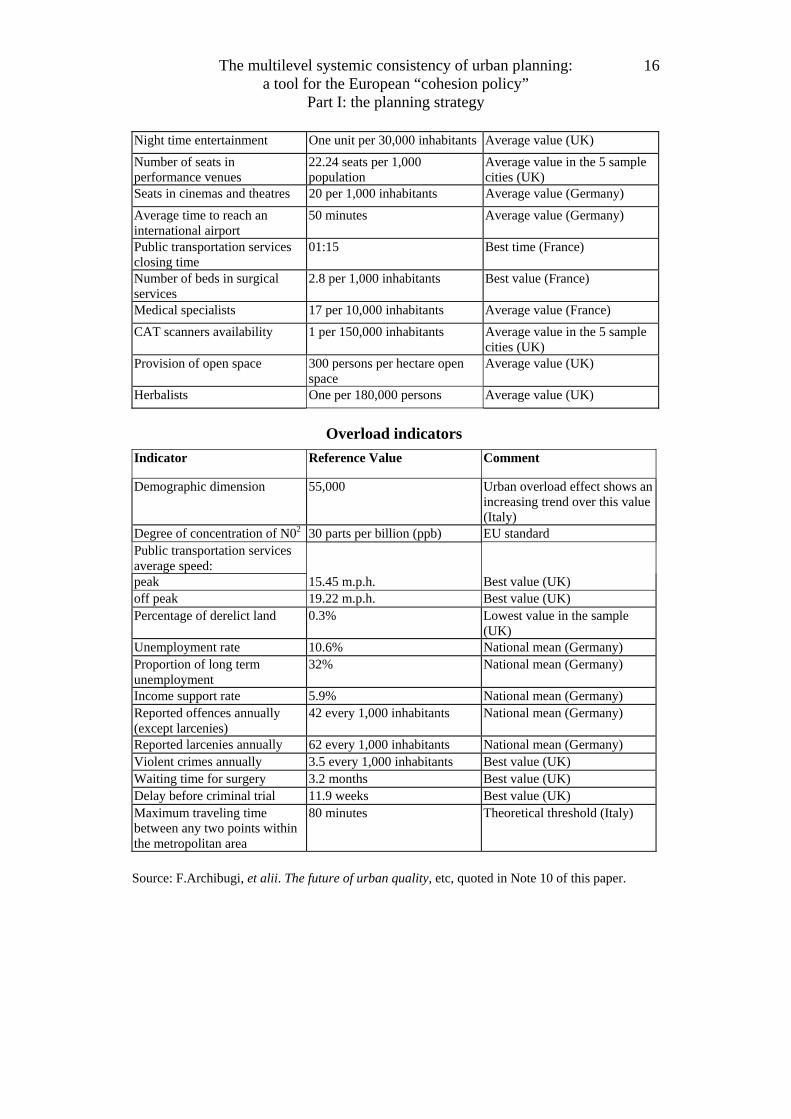
Source: F.Archibugi, et alii. The future of urban quality, etc, quoted in Note 10 of this paper.

The multilevel systemic consistency of urban planning: a tool for the European “cohesion policy”
Part I: the planning strategy
15
City Effect Indicators Indicator Reference Value Comment
Population density 10.5 persons per hectare Average value in the 5 sample cities, short of external standards (UK)
Demographic dimension 361,000 inhabitants (higher thresholds if tertiary activity is more than 49%)
City Effect increases with urban size up to a certain point (361,000 inhabitants) and then decreases. Higher threshold if tertiary activity is more than 49% (Italy)
Headquarters location: number of trading premises (headquarter sites of companies located in the area with turnover of more than £20 million relative to population size)
4800 persons per company Average value in the 5 sample cities, short of external standards (UK)
New firm formation 0.003 registrations per head of population
A surrogate for the level of entrepreneurial activity. Average value in the 5 sample cities, short of external standards (UK)
Number of applications for business start-up loans
23 per 10,000 heads of population
Average value, short of external standards (Germany)
Level of employment in the tertiary sector
Over 75% Average national value (UK)
R&D employment 10 per 100 heads of population Relative level of technological development and entrepreneurship. Average value in the 5 sample cities (UK)
Occupation in the arts 13 per 10,000 heads of population
Average value in the 5 sample cities (UK)
Art galleries One service unit per 33,400 heads of population
Value of the urban system used as exemplary (Italy)
Share of population that can reach the following facilities within 10 minutes (%):
Best value for cities over 500,000 inhabitants (Germany)
Retail shop/supermarket over 90%
Physician 88.1%
School over 80%
Kindergarten over 75%
Public transport connection 99%
Pub over 95%
Park over 85%
Retail sales area over 1.5 sq. m. per inhabitant National mean (Germany)
The multilevel systemic consistency of urban planning: a tool for the European “cohesion policy”
Part I: the planning strategy
16
Night time entertainment One unit per 30,000 inhabitants Average value (UK)
Number of seats in performance venues
22.24 seats per 1,000 population
Average value in the 5 sample cities (UK)
Seats in cinemas and theatres 20 per 1,000 inhabitants Average value (Germany)
Average time to reach an international airport
50 minutes Average value (Germany)
Public transportation services closing time
01:15 Best time (France)
Number of beds in surgical services
2.8 per 1,000 inhabitants Best value (France)
Medical specialists 17 per 10,000 inhabitants Average value (France)
CAT scanners availability 1 per 150,000 inhabitants Average value in the 5 sample cities (UK)
Provision of open space 300 persons per hectare open space
Average value (UK)
Herbalists One per 180,000 persons Average value (UK)
Overload indicators
Indicator Reference Value Comment
Demographic dimension 55,000 Urban overload effect shows an increasing trend over this value (Italy)
Degree of concentration of N02 30 parts per billion (ppb) EU standard Public transportation services average speed:
peak 15.45 m.p.h. Best value (UK) off peak 19.22 m.p.h. Best value (UK) Percentage of derelict land 0.3% Lowest value in the sample
(UK) Unemployment rate 10.6% National mean (Germany) Proportion of long term unemployment
32% National mean (Germany)
Income support rate 5.9% National mean (Germany) Reported offences annually (except larcenies)
42 every 1,000 inhabitants National mean (Germany)
Reported larcenies annually 62 every 1,000 inhabitants National mean (Germany) Violent crimes annually 3.5 every 1,000 inhabitants Best value (UK) Waiting time for surgery 3.2 months Best value (UK) Delay before criminal trial 11.9 weeks Best value (UK) Maximum traveling time between any two points within the metropolitan area
80 minutes Theoretical threshold (Italy)
Source: F.Archibugi, et alii. The future of urban quality, etc, quoted in Note 10 of this paper.
The multilevel systemic consistency of urban planning: a tool for the European “cohesion policy”
Part I: the planning strategy
17
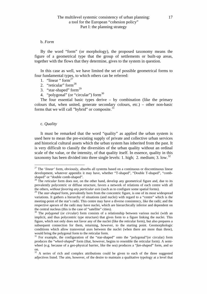
b. Form By the word “form” (or morphology), the proposed taxonomy means the
figure of a geometrical type that the group of settlements or built-up areas, together with the flows that they determine, gives to the system in question.
In this case as well, we have limited the set of possible geometrical forms to
four fundamental types, to which others can be referred: 1. “linear “ form27 2. “reticular” form28 3. “star-shaped” form29 4. “polygonal” (or “circular”) form30 The four essential basic types derive – by combination (like the primary
colours that, when united, generate secondary colours, etc.) – other non-basic forms that we will call ”hybrid” or composite.31
c. Quality It must be remarked that the word “quality” as applied the urban system is
used here to mean the pre-existing supply of private and collective urban services and historical cultural assets which the urban system has inherited from the past. It is very difficult to classify the diversities of the urban quality without an ordinal scale of the value, or the intensity, of that quality itself. In essence, quality in this taxonomy has been divided into three single levels: 1. high; 2. medium; 3. low.32
27 The ‘linear’ form, obviously, absorbs all systems based on a continuous or discontinuous linear development, whatever appendix it may have, whether “T-shaped”, “Double T-shaped”, “comb-shaped” or “double comb-shaped”. 28 The reticular form does not, on the other hand, develop any geometrical figure and, due to its prevalently polycentric or diffuse structure, favors a network of relations of each centre with all the others, without favoring any particular axis (such as to configure some spatial forms). 29 The star-shaped form, prevalently born from the concentric figure, is one of its most widespread variations. It gathers a hierarchy of situations (and nuclei) with regard to a “centre” which is the meeting-point of the star’s radii. This centre may have a diverse consistency, like the radii; and the respective apexes of the radii may have nuclei, which are hierarchically inferior and dependent on the central nucleus (this is the case of “satellite” cities). 30 The polygonal (or circular) form consists of a relationship between various nuclei (with an implicit, and thus polycentric type structure) that gives form to a figure linking the nuclei. This figure, which not only does not favor any of the nuclei (like the reticular form), but also prepares a subsequent connection for them, returning, however, to the starting point. Geomorphologic conditions which allow transversal axes between the nuclei (when there are more than three), would bring the polygonal form to the reticular form. 31 For example, the configuration of the “star-shaped” onto the “polygonal”(or circular) form produces the “wheel-shaped” form (that, however, begins to resemble the reticular form). A semi-wheel (e.g. because of a geo-physical barrier, like the sea) produces a “fan-shaped” form, and so on. 32 A series of rich and complex attributions could be given to each of the three suggested adjectives listed. The aim, however, of the desire to maintain a qualitative typology at a level that
The multilevel systemic consistency of urban planning: a tool for the European “cohesion policy”
Part I: the planning strategy
18
The typology of the urban system according to structure, form and quality, provides a polyhedral set of cases that correspond to the connection of the various types.33
3. A typology according the planning strategy But the most important feature of the adopted taxonomy in the research has
been the introduction of a “policy-oriented” pattern: the “strategic” pattern, where strategy means the planning (or programming) intervention or approach, suggested by the urban system policy aimed at the city effect re-equilibrium (or greater cohesion).
This type of planning intervention or approach grasps the diversity between the various urban systems from the point of view – as said – of strategy. This classification has become a very important instrument for the purposes of any urban systems policy.
3.1 An essential typology of strategic role Wishing, however, to reduce to a minimum this classification of the
interventions regarding this latter strategy, we have considered it worthwhile to define only three types of strategy.
1. “polarisation” strategy; 2. “de-polarisation” strategy; 3. “rationalisation” strategy;
is at the same time, both sufficiently general and linked to the classification of requirements, that suggested limiting the attribution in the following way: - the “high” level has all the superior urban services which are capable of producing the city
effect; - the “medium” level has many of the above, but not all; - the “low” level has only a few, or none at all. 33 Three types of structure by four types of form by three types of quality give exactly thirty-six theoretically possible connections, and thus ideal typical models of the urban systems. Some of the theoretical connections between the types of structure-form-quality have, however, an intrinsic contradiction, conceptual in nature that renders their identification in concrete cases very improbable. For example, it is rather difficult to imagine a concentric-shaped system that has a continuously reticular morphology, or a system with a diffuse structure, with a co-terminal star-shaped morphology. Nevertheless, connections in the great majority of cases are possible, even if they are not all found in a given particular national case. Geomorphologic conditions will strongly condition the presence or absence of this or that group of typologies. For example, it is doubtful whether typologies with a constantly present reticular form can be produced in geomorphologic conditions that have a high aerographical presence or with altitude differences. The polyhedron that arises from the set of interconnections between structural, formal and qualitative typologies constitutes a multi-dimensional matrix in which – as mentioned – not all the cells are likely to be filled; and there will not be (even theoretically) the urban systems that are susceptible to being ascribed to any of those cells. (More considerations on this matter are in the already quoted book by F Archibugi, 1995a.)

The multilevel systemic consistency of urban planning: a tool for the European “cohesion policy”
Part I: the planning strategy
19
The “polarisation” strategy is characteristic of all those systems which have a future potential to reach, with a strategic intervention, the requirements of the urban system and thus of the “city effect”. This is particularly true if they manage to overcome the present centrifugal dispersion of many areas and nuclei towards “poles” that are external to the identified system. Therefore, the “polarisation” strategy concerns these urban systems that can be seen in terms of “re-equilibrium”, in as much as they were more or less adjacent to already consolidated metropolitan systems to which they have to represent an alternative in order to “overturn” the gravitation, at least in their more peripheral parts.
The “de-polarisation” strategy, on the other hand, is characteristic of all those systems whose supporting axis currently suffers from an excessive centripetal gravitational capacity, producing an effect of congestion which risks paralysing the functioning of the system itself and produces a “periphery” effect in the same over-extended system. The strategy of “de-polarisation” concerns, in essence, those urban systems “based on the current metropolitan areas”.
The “rationalisation” strategy is characteristic of all the systems which, while there is not excessive polarisation and thus no need for “de-polarisation”, still do not have equilibrium in the functional distribution of activities, (and therefore of flows) within their territory. These systems, while being potentially autonomous towards the outside, must still reach the type of internal “organisation” that can allow them to achieve the critical threshold of functional integration for the installation of superior urban services.
The intervention or approach concerns, obviously, the transition of a certain territory already configured, or only configurable, as an (urban) system from a present state to a future (programmatic) state. The transition is, in fact, realised by the planning intervention and approaches (and not by a mere spontaneous evolution of the circumstances). 34
This is why the typology of urban systems according to the strategy to be adopted for them, constitutes the “core” of an urban systems policy (as understood in this research).35
However, this brings about some further considerations regarding the relationship between characterisation of urban systems by type (typology) and their strategic planning.
34 In chapter 15 of the quoted research book is outlined how the strategy for the realization of urban systems presents itself. I reproduce in Table 3 an example of diversification of strategy according to the structure of systems in question. 35 More arguments on the roll of the typology of urban systems according to the strategy for an urban policy are debated in chapters 11 & 12 of the quoted research book.

The multilevel systemic consistency of urban planning: a tool for the European “cohesion policy”
Part I: the planning strategy
20
[As derived from the cross-section of ‘strategic’ and structural characters of the typology proposed]
Plan’s strategy A. Polarization B. De-polarization C. Rationalization
Structural character General Objective: Discouraging extra-systemic gravitations.
General Objectives: Encouraging extra-systemic gravitation. Privileging infra-systemic gravitation.
General Objective: Increasing the quality of the infra-systemic functional integration.
I. Concentric I-A. (very rare case) Privileging the main Nucleus and concentrating the rare services there.
I-B Diminishing the specific weight of the concentric Nucleus. Creating extra-systemic alternative polarities. Discouraging communications with adjacent Systems. Dismembering cases of gigantism in the service Units. Protecting the free areas of the System.
I-C Researching alternative polarities within the System. Dismembering the superior service Units, excessively concentrated (giants) and de-localising them in the territory. Protecting the balance between intensive zones and free areas. Strenuously protecting the last free areas.
II. Polycentric II-A Concentrating rare Services into few Nuclei or Centres of the bearing-Axis. Discouraging extra-systemic gravitations
II-B Increasing the ‘reciprocity’ flows between Nuclei and Centre of the System. Interrupting or disturbing the extra-systemic gravitations. Specializing the functions of Nuclei.
II-C Specializing the functions of Nuclei. Assuring circular fluidity of the extra-systemic relations.
III. Diffuse III-A Concentrating (new) rare Services only in a Nucleus or Centre of the bearing-Axis. Privileging the acquisition of clear formal characters.
III-B (An extremely improbable case)
III-C (very rare case) Ensuring broad access to all services. Encouraging the acquisition of character and identity.
Source: F.Archibugi, Teoria dell’Urbanistica, Rome 1996. Table 11.1
3.2 Typology of pattern according to plan’s strategy This typology is an instrument for the “reading” of the city, or the urban
system. It is indifferent, however, to the type of reading carried out, whether of the existing reality (present) or of the plan reality (future). 36
In town planning, the typology may concern both of these types of reading. The typology (structure, form, quality) may help to describe the present reality of the urban system (once the requirements have been identified and ratified), or to describe the reality of the plan, i.e. the future reality as designed from the plan .
The type according to strategy, however, only concerns the transition between present reality and plan reality; thus it is not divided – like the other typologies – according to the reading of the present or of the plan.
The transition between present reality and that of the plan, which gives meaning to the “designability” of town planning, implies the need never to confuse a typology of the present with one of the plan, except in the strategic case.
3.3 .The strategy as interdependency between ‘urban systems’ Strategies are articulated into two aspects:
1. The strategy concerning the desired programmatic and future “consolidation” of the urban system in question, on the foundation of functional components which it must acquire as an essential requirements for being an “urban system”;37
2. The strategy concerning the salient features of interdependency between the urban systems and of the interventions proper to each urban system, to give it a configuration coherent with the general strategy described in point 1 above. The first aspect of the strategy is general and common to all the identified
urban systems: it is a question only of indicating, configuring and designing the geomorphologic circumstances and pre-existence of each. The second aspect of the strategy implies a “diversification” of the type of intervention and thus of the strategy itself (albeit in general terms). This gives rise to a real typology of urban systems regarding the strategy of interdependence of these systems.
Instead of developing the specific urban policy suitable for each of the two types of strategies that the research tried to identify, I consider it more useful
36 On the question of the “reading” of plans there are some interesting reflections in Mandelbaum (1985, 1990). 37 In other words, the strategy indicates the load-bearing axis, the free area, the service centres, the support infrastructural lines, the sub-systems of environmental and heritage-cultural recovery, etc. all of which constitute the components of a programmatic urban system, even in the case in which these components are not yet actual. (For more information on these components see my work on the foundations of city planning; (Archibugi, 1995a.)
here38 to illustrate concretely how the scenario of territorial reorganisation by urban systems has been formulated for the four countries considered.
In fact, it is perhaps opportune for the reader to assess the strategic typology and the subsequent policies while having in hand, as a reference, the actual territorial units which should be the object of this strategy (and thus, the object of the urban policy), which this research has aimed at outlining in general.
This is what will be seen in the Part II of this paper.
References of the Part I Archibugi F. (1980). Principi di pianificazione regionale. 2 vols. Milano, Franco
Angeli. Archibugi F. (1992). Towards a New Discipline of Planning. The First World-
wide Conference on Planning Science, Palermo, 8-11 September 1992; published in: Socio-economic planning sciences, vol.30, n.2, pp.81-102, 1996.
Archibugi Franco (1994). “Ecological Equilibrium and Territorial Planning: The Italian Case.” European Planning Studies 2(2): 175-91.
Archibugi F.(1995a). The Theory of Urbanistics: Lectures on a Reappraisal of City Planning Methodology (Summer Course on Development and Conservation Strategies for Very Large Cities, University of Pennsylvania, University of Southern California ant the Planning Studies Centre, Rome 1-30 June 1995). Rome, Planning Studies Centre.
Archibugi F. (1995b). A Strategy for the Modern City: Research Guideline Oriented to the Identification of the "Optimal Centrality", (IX AESOP Congress, Glasgow). Glasgow.
Archibugi F. (1997). The Ecological City and the City Effect. Essays on the Urban Planning Requirements of the Sustainable City. London, Ashgate Publishing.
Archibugi, 2003, Planning theory: from the politological debate to the methodological reconstruction, (It.ed.Firenze, Alinea)(Eng. Edit., forthcoming).
Berry B. J. L. (1980). “Urbanization and Counter-Urbanization.” Annals of Association of American Geographers, 457: 13-20.
Bertuglia C. S.et alii eds, Ed. (1987). Urban systems: contemporary approaches to modeling. London-New York, Croom Helm.
Bertuglia C.S. Leonardi G. Wilson A.G. eds, Ed. (1990). Urban dynamics: designing an integrated model. London-New York, Routledge.
Bertuglia C. S. G.P.Clark and A.G.Wilson, Eds. (1994). Modelling the City: Performance, Policy and Planning. London, Routledge.
Bertuglia C. S. Bianchi G. Mela A. eds, Ed. (1998). The city and its sciences. Heidelberg/New York, Physica-Verlag.
38 A broader discussion on the criteria and the methodology from which to derive the urban policies, through the cross-section of formal and strategic models and patterns (at the scale of urban systems), would take too much space and has already been developed in my work, repeatedly quoted, on the foundations of city planning (Archibugi 1995a).

Bird R. A. (1968). The Relationship of Economic and Physical Planning (Paper presented at Town and Country Planning Summer School). Manchester, University of Manchester.
Bird J. H. (1977). Centrality and Cities. London, Routledge. Cooke Ph., (1984). Theories of Planning and Spatial Development (The Living
Environment) London, Hutchinson, European Commission (1996). Prospects for the Development of the Central and
Capital Cities and Regions. Brussels, European Commission. European Commission , (1997), On the Systems and Policies of Spatial Planning”
Bruxelles. European Commission (1999a). The structural Funds and their Coordination with
the Cohesion Fund. Guideline for Programmes in the Period 2000-2006. Luxembourg.
European Commission (1999b). European Spatial Development Perspective: Towards Balanced and Sustainable Development of the Territory of the EU. Luxembourg.
European Commission (2000). Spatial Perspective for the Enlargement of the European Union (Regional Development Studies no.36) . Luxembourg.
European Commission (2001). Second Report on Economic and Social Cohesion 2001. Luxembourg.
Faludi A. (1986). Critical Rationalism and Planning Methodology. London, Pion Press.
Faludi A. (1987). A Decision-Centered View of Environmental Planning. Oxford, Pergamon.
Faludi A. and Waterhout, B. (2002). The making of the European spatial development perspective: No Masterplan. London, New York, Routledge.
Hall P.(1979). Growth and Transformation of the Modern City. I. The European City in the Year 2000.Hammarstrom. Stockholm.
Hall P.(1995a). The European City: Past and Future. In: P. Hall , ed, The European City: Sustaining Urban Quality. Copenhagen.
Hall P (1995b). “The future of cities in Western Europe.” European Review,Vol.3 No.2,161-169.
Hall P. (1996). “Revisiting the Nonplace Urban Realm: Have We Come Full Circle?” International Planning Studies.
Hall P. (1997). “Modelling the post-industrial city.” Futures 29(4/5): 311-322. Hall P.(1999). “The future of cities.” Computers, Environment and Urban System Hall P. and Hay, D. (1971). Urban Regionalisation of Great Britain. Reading,
University Reading, Geography Department. Harvey D.(1973), Social justice and the city. London, Edward Arnold, 1973 Harvey D.(1985) The urbanization of capital : studies in the history and theory of
capitalist urbanization Baltimore, Md. : John Hopkins University Press. Harvey D. (2003). The New Imperialism. Oxford, Oxford University Press. Harvey D, (2006). Spaces of global capitalism : a theory of uneven geographical
development. London ; New York, NY : Verso.

Isard W. et alii (1969). General Theory: Social, Political, Economic, and Regional, with Particular Reference to Decision- Making Analysis. Cambridge, Mass., MIT Press.
Isard W. et alii, Ed. (1998). Interregional and Regional Science Methods: An Introduction to Regional Science. Hampshire, Ashgate.
Kunzmann K.R. and Wegener M. (1991). The pattern of urbanisation in western Europe 1960-1990. Dortmund, Institut fur Raumplanung Universitat Dortmund.
Mandelbaum S.J. (1985). “Historians and planners: the construction of pasts and futures.” Journal of the APA 51: 185.188.
Mandelbaum S. J. (1990). “Reading Plans.” Journal of the American Planning Association 56: 350-356.
Planning Studies Centre (PSC), The Future of the Urban Quality in Europe: Towards a New Concept and Strategy of “European Urban System” Editor: F.Archibugi. (Rome 2003, second edition)
Rautsi J., Ed. (1993). The European City Today: The Helsinki Round Table on Urban Improvement Strategies. Helsinki, Ministry of the Environment.
Sassen S. (1994). ‘A new geography of centers and margins: summary and implications’. from: Cities in a world economy. In R.T.LeGates and F.Stout, eds, The city reader (readings) (1996) London, Routledge.
Sassen S. (1996). The Global City. In: Susan Feinstein and S. Campbell eds., Urban Theory. London, Blackwell.
Sassen S., Ed. (2002). Global Networks, Linked Cities, Spon Press. Webber M. M. (1964). ‘The Urban Place and the Non-Place Urban Realm’. In
M.M-Webber ed. Explorations into Urban Structure. Philadelphia, University of Pennsylvania Press.