The Middle Atlas Domain of Morocco: Geoheritage ...
4
Proceedings of the 5 th International YES Congress DOI: 10.2312/yes19.24 © CC-BY 4.0, except where otherwise noted. The Middle Atlas Domain of Morocco: Geoheritage Conservation Allowing Development In A Sustainable Manner Souhail Mounir 1,* , Naoufal Saoud 1 , Kaoutar Mounir 2 , Jaouad Choukrad 1 , Abir Berbeche 3 , Mohamed Charroud 1 1 Faculty of Sciences and Technologies Fez (FSTF), Fez, Morocco 2 Faculty of Science Dhar El Mahraz Fez (FSDM), Fez, Morocco 3 National School of Applied Sciences Fez (ENSAF), Fez, Morocco * [email protected] Keywords: Geo-heritage, Georesources management, Conservation, Central Middle Atlas 1. Introduction Many natural sites in Morocco are geologically rich, especially in the Atlasic area. The potential of these geosites with their geologically diverse and complex features has been recognized by geologists world- wide. Yet, studies in geotourism and the sustainable development of these sites are generally lacking. Su- manapala and Wolf (2020), who reviewed the field of geotourism, found that although geotourism clearly constitutes an emerging sub-sector of nature-based tourism with great potential, only 26 studies have been published in this field in peer reviewed journals to date. A lack of knowledge on how to assess the potential of geotourism sites has impeded their de- velopment as opportunities are not fully recognized. Assessments of the strength and weaknesses, along with opportunities and threats of geosites were rec- ommended (Mounir, 2020). Here we contribute to filling this gap by discussing the Middle Atlas in Morocco as a potential geotourism site. We evaluate the socio-economic, cultural and environmental conditions as they provide opportuni- ties for development, and discuss the threats that im- pede such a development. Figure 1: Geological Map of the Middle Atlas (after Mounir, 2020)
Transcript of The Middle Atlas Domain of Morocco: Geoheritage ...

Proceedings of the 5th International YES CongressDOI: 10.2312/yes19.24© CC-BY 4.0, except where otherwise noted.
The Middle Atlas Domain of Morocco: Geoheritage Conservation Allowing Development In A Sustainable Manner
Souhail Mounir1,*, Naoufal Saoud1, Kaoutar Mounir2, Jaouad Choukrad1, Abir Berbeche3, Mohamed Charroud1
1 Faculty of Sciences and Technologies Fez (FSTF), Fez, Morocco2 Faculty of Science Dhar El Mahraz Fez (FSDM), Fez, Morocco3 National School of Applied Sciences Fez (ENSAF), Fez, Morocco * [email protected]
Keywords: Geo-heritage, Georesources management, Conservation, Central Middle Atlas
1. IntroductionMany natural sites in Morocco are geologically rich,
especially in the Atlasic area. The potential of these geosites with their geologically diverse and complex features has been recognized by geologists world-wide. Yet, studies in geotourism and the sustainable development of these sites are generally lacking. Su-manapala and Wolf (2020), who reviewed the field of geotourism, found that although geotourism clearly constitutes an emerging sub-sector of nature-based tourism with great potential, only 26 studies have been published in this field in peer reviewed journals
to date. A lack of knowledge on how to assess the potential of geotourism sites has impeded their de-velopment as opportunities are not fully recognized. Assessments of the strength and weaknesses, along with opportunities and threats of geosites were rec-ommended (Mounir, 2020).
Here we contribute to filling this gap by discussing the Middle Atlas in Morocco as a potential geotourism site. We evaluate the socio-economic, cultural and environmental conditions as they provide opportuni-ties for development, and discuss the threats that im-pede such a development.
Figure 1: Geological Map of the Middle Atlas (after Mounir, 2020)

We highlight how the varied geomorphological and related elements of this geographic area showcase the geologically complex evolution of the Middle Atlas during the Meso-Cenozoic and the Quaternary. The rich portray of geological evolution lends itself to mar-keting and promotion of this site for geotourism.
2. Location and settingThe Middle Atlas (study area) is a part of the Atlasic
domain. It is limited in the North by the South-Rifain corridor, in the East by the valley of the Middle Mou-louya, in the South by the High Atlas of Beni Mellal,
and in the West by the central land (Western Meseta). The Middle Atlas is essentially represented by an-
ticlinal rifts intruded by gabbroic formations, and with separate large synclinal basins that translate a com-plex geological history during the Meso-Cenozoic and the Quaternary (Termier, 1936; Choubert and Faure-Muret, 1962; Charroud, 1990; Michard et al., 2008, Hinaje et al., 2015, Mounir et al., 2019).
The mountainous region is formed by a juxtaposi-tion of two major structural domains. The Tabular Mid-dle Atlas (Middle Atlasic causse) formed essentially by the carbonate formations of the Lias in the form by layered plateaus. The North Middle Atlasic fault (NMAF) separates the tabular domain from the folded Middle Atlas. The latter is marked by a series of folds and faults forming ripples separated by synclines with marine and continental Dogger formations (Figure 1).
3. Geo-heritage processThe heritage process is subject to several stages of
characterization, preservation, reclamation and geo-
Figure 2: The main approaches, methods and interventions in the heritage industry process.
Figure 3: Examples of geological sites of special interest in the Middle Atlas. a-b. The Middle Atlas Heritage Interpretation Centre. c. Guigou meander (Taferdoust Kasbah). d. The Sources Oum er-Rbia Waterfall. e. Aguelmam Azigza National Park. f. The bathonian Theropod Trackways of the Central Middle Atlas. g. Karst reliefs and landforms. h. Azurite and malachite. i-j. The Plio-Quaternary volcanism of the Middle Atlas.
logically remarkable trail display. It reflects the emer-gence of a specific mode of territorial development and ensures a holistic approach to geoconservation (Mounir et al., n. d.).
The main purpose of this work is to present a gener-al perspective on geological heritage, focusing mainly on concepts, terminology and methods of identifica-tion and evaluation, to understand and give a general overview of the spatial and temporal evolution of the geological history of the Middle Atlas, thus bringing new scientific and socio-cultural approaches to the region (Figure 2).
4. The geological heritage of the Middle Atlas and its opportunities and strengths as a geotourism area
The Middle Atlas is a well-known outcrop set be-cause of its stratigraphic relevance, which reflects the geodynamic history of the region. The diversity of these outcrops justifies the implementation of several strategies aimed at prioritizing geosites as a scientific place, educational, aesthetic and cultural interest. For this purpose, a systematic identification, characteri-zation and evaluation of the geosites was carried out, taking into consideration the assessed interest, the rarity and the exceptional conservation status that the Middle Atlasic domain represents.
The geological heritage must be appreciated by the community; therefore the engagement with a large section of the society, through geotourism, may be an effective way to expand the importance of geological heritage as a valued part of the natural world (Sharp-les, 2002; Crofts and Gordon, 2015).
Consequently, after an analysis of the relationships between geological heritage and geotourism, Figure 3 illustrates several examples of the Middle Atlasic geoheritage in different geological contexts.
5. The threats and weaknesses of the Middle Atlas as a geotourism area
Geosciences are still poorly displayed in Morocco, or not at all concerned by administrative acts. The speech is strongly aimed to MEM ministries by geo-science scientists and researchers during the last na-tional and international meetings.
However, Morocco still has no law for the protection of its geological heritage, especially its internationally important fossil sites of Paleo-Mesozoic age, which are very vulnerable and at risk of disappearing due to their over-exploitation as ornamental rocks and fossil sites (Mounir, 2020).
6. Concluding remarks about the future of the Middle Atlas as geotourism region
A positive development was noted recently in the creation of the ‘Geology Direction’ framework and the integration of a geological heritage service and mu-seums in a national road framework for the develop-ment of geological and geothematic infrastructure for the period 2015–2025 (MEMEE, 2015; Mounir, 2020).
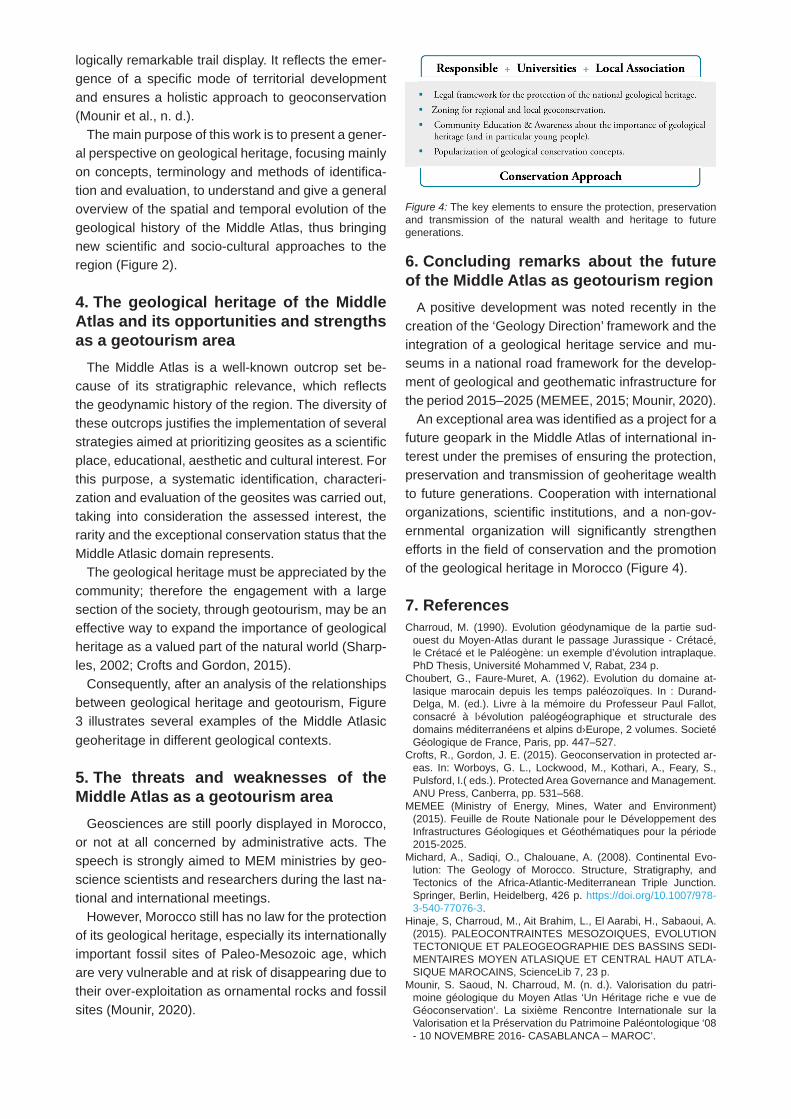
An exceptional area was identified as a project for a future geopark in the Middle Atlas of international in-terest under the premises of ensuring the protection, preservation and transmission of geoheritage wealth to future generations. Cooperation with international organizations, scientific institutions, and a non-gov-ernmental organization will significantly strengthen efforts in the field of conservation and the promotion of the geological heritage in Morocco (Figure 4).
7. ReferencesCharroud, M. (1990). Evolution géodynamique de la partie sud-
ouest du Moyen-Atlas durant le passage Jurassique - Crétacé, le Crétacé et le Paléogène: un exemple d’évolution intraplaque. PhD Thesis, Université Mohammed V, Rabat, 234 p.
Choubert, G., Faure-Muret, A. (1962). Evolution du domaine at-lasique marocain depuis les temps paléozoïques. In : Durand-Delga, M. (ed.). Livre à la mémoire du Professeur Paul Fallot, consacré à l›évolution paléogéographique et structurale des domains méditerranéens et alpins d›Europe, 2 volumes. Societé Géologique de France, Paris, pp. 447–527.
Crofts, R., Gordon, J. E. (2015). Geoconservation in protected ar-eas. In: Worboys, G. L., Lockwood, M., Kothari, A., Feary, S., Pulsford, I.( eds.). Protected Area Governance and Management. ANU Press, Canberra, pp. 531–568.
MEMEE (Ministry of Energy, Mines, Water and Environment) (2015). Feuille de Route Nationale pour le Développement des Infrastructures Géologiques et Géothématiques pour la période 2015-2025.
Michard, A., Sadiqi, O., Chalouane, A. (2008). Continental Evo-lution: The Geology of Morocco. Structure, Stratigraphy, and Tectonics of the Africa-Atlantic-Mediterranean Triple Junction. Springer, Berlin, Heidelberg, 426 p. https://doi.org/10.1007/978-3-540-77076-3.
Hinaje, S, Charroud, M., Ait Brahim, L., El Aarabi, H., Sabaoui, A. (2015). PALEOCONTRAINTES MESOZOIQUES, EVOLUTION TECTONIQUE ET PALEOGEOGRAPHIE DES BASSINS SEDI-MENTAIRES MOYEN ATLASIQUE ET CENTRAL HAUT ATLA-SIQUE MAROCAINS, ScienceLib 7, 23 p.
Mounir, S. Saoud, N. Charroud, M. (n. d.). Valorisation du patri-moine géologique du Moyen Atlas ‘Un Héritage riche e vue de Géoconservation’. La sixième Rencontre Internationale sur la Valorisation et la Préservation du Patrimoine Paléontologique ‘08 - 10 NOVEMBRE 2016- CASABLANCA – MAROC’.
Figure 4: The key elements to ensure the protection, preservation and transmission of the natural wealth and heritage to future generations.

Mounir, S., Saoud, N., Charroud, M., Mounir, K., Choukrad, J. (2019). The Middle Atlas Geological karsts forms: Towards Ge-osites characterization. Oil & Gas Science and Technology - Rev. IFP Energies nouvelles 74(17), 9 p. https://doi.org/10.2516/ogst/2018089.
Mounir, S. (2020). Le patrimoine géologique du Moyen Atlas et la Haute Moulouya: identification, caractérisation et valorisation. PhD Thesis, Université Sidi Mohammed Ben Abdellah, Fez, 350 p.
Sharples, C. (2002). Concepts and Principles of Geoconservation (version 3). Tasmanian Parks & Wildlife Service, Hobart, 79 pp.
Sumanapala, D., Wolf, I. D. (2020). Man-Made Impacts on Emerg-ing Geoparks in the Asian Region. Geoheritage 12(3), 1–9. https://doi.org/10.1007/s12371-020-00493-0.
Termier H. (1936). Etudes géologiques sur le Maroc central et le Moyen Atlas septentrional, 4 volumes. Notes et mémoires (Mo-rocco. Service des mines et de la carte géologique) 33, Imprim-erie officielle, Rabat.