THE MASTER PLAN STUDY ON RESTORATION ...open_jicareport.jica.go.jp/pdf/11780624_01.pdfKhawr Hajar -...
146
Japan International Cooperation Agency (JICA) Ministry of Regional Municipalities, Environment and Water Resources (MRMEWR) The Sultanate of Oman THE MASTER PLAN STUDY ON RESTORATION, CONSERVATION AND MANAGEMENT OF MANGROVE IN THE SULTANATE OF OMAN Final Report Vol. 1 Main Report July 2004 Pacific Consultants International Appropriate Agriculture International Co., Ltd No. 04-035 JR G E
Transcript of THE MASTER PLAN STUDY ON RESTORATION ...open_jicareport.jica.go.jp/pdf/11780624_01.pdfKhawr Hajar -...

Japan International Cooperation Agency (JICA) Ministry of Regional Municipalities, Environment and Water Resources (MRMEWR) The Sultanate of Oman
THE MASTER PLAN STUDY ON
RESTORATION, CONSERVATION AND MANAGEMENT OF MANGROVE
IN THE SULTANATE OF OMAN
Final Report
Vol. 1 Main Report
July 2004
Pacific Consultants International Appropriate Agriculture International Co., Ltd
No.
04-035
JR
G E

Japan International Cooperation Agency (JICA) Ministry of Regional Municipalities, Environment and Water Resources (MRMEWR) The Sultanate of Oman
THE MASTER PLAN STUDY ON
RESTORATION, CONSERVATION AND MANAGEMENT OF MANGROVE
IN THE SULTANATE OF OMAN
Final Report
Vol. 1 Main Report
July 2004
Pacific Consultants International Appropriate Agriculture International Co., Ltd

The exchange rate applied in this study is R.O.1=JPY275.9 (As of January 2004)

PREFACE
In response to a request from the Government of the Sultanate of Oman, the Government of Japan decided to conduct the study to develop the master plan for restoration, conservation and management of mangrove in the Sultanate of Oman. JICA selected and dispatched the study team headed by Mr. Tadashi Kume of Pacific Consultants International and consisting of Pacific Consultants International and Appropriate Agriculture International Co., Ltd. to Oman between June 2002 and July 2004. It is with great pleasure that I acknowledge the close collaboration between the Ministry of Regional Municipalities, Environment and Water Resources and the JICA study team, which resulted in the formulation of the master plan. I strongly wish that this master plan, formulated with under the strong initiative of the Ministry of Regional Municipalities, Environment and Water Resources, will contribute to the restoration, conservation and management of mangroves in the Sultanate of Oman. Finally, I wish to express my sincere appreciation to all the officials concerned of the Government of Oman for their cooperation and support extended to the team. July 2004 Etsuo Kitahara Vice President Japan International Cooperation Agency

Mr. Etsuo KITAHARA July 2004 Vice President Japan International Cooperation Agency Tokyo, Japan
Letter of Transmittal Dear Sir, We are pleased to formally submit herewith the Final Report of “The Master Plan Study on Restoration, Conservation and Management of Mangrove in the Sultanate of Oman.”
This report compiles the results of the study, which was conducted from June 2002 through July 2004 by the study team organized by Pacific Consultants International and Appropriate Agriculture International Co., Ltd. under the contract with JICA.
The study team compiled this report, which proposed the future conservation and management scenario and master plan up to 2024, and short-term, medium-term, and long-tem action plans up to 2006, 2009, and 2014 respectively, through close consultations with officials of the Ministry of Regional Municipalities, Environment and Water Resources and other authorities concerned.
We would like to express our sincere gratitude and appreciation to the officials of your agency and the JICA advisory committee. We also would like to send our great appreciation to all those who extended their kind assistance and co-operation to the study team, in particular to the Ministry of Regional Municipalities, Environment and Water Resources and regional officials concerned.
We hope that the master plan will be able to contribute significantly to the development of the mangrove conservation and management system in Oman.
Very truly yours,
Tadashi KUME Team Leader, The Master Plan Study on Restoration, Conservation and Management of Mangrove in the Sultanate of Oman

Abbreviations
CAD Computer-Aided Design COD Chemical Oxygen Demand DG Director General DO Dissolved Oxygen EEZ Exclusive Economic Zone EIA Environmental Impact Assessment GCC Gulf Co-operation Council GIS Geographical Information System GOJ Government of Japan GOO Government of Oman GPS Geographical Positioning System HTML Hypertext Makeup Language IUCN International Union for the Conservation of Nature and Natural
Resources (The World Conservation Union) JICA Japan International Cooperation Agency MAF Ministry of Agriculture and Fisheries MCI Ministry of Commerce and Industry MD Ministerial Decision MPCZMS Marine Pollution and Coastal Zone Management Section MPEC Mangrove Plantation Experimental Centre MRMEWR Ministry of Regional Municipalities, Environment and Water
Resources NR Nature Reserve QEIC Qurm Environmental Information Centre RA Recreation Area RD Royal Decree RDA Recreational Development Area ROPME Regional Organisation for the Protection of the Marine Environment RTK Real Time Kinematics of Oman SQU Sultan Qaboos University SR Scenic Reserve UAE United Arab Emirates UNESCO United Nations Educational, Scientific and Cultural Organisation

English Spelling of Place-names in the Report
There were some difficulties in writing in English the Arabic names for the Region/Governorate, Wilayat, Locality and Study Sites. One place was spelled in different ways in official documents and maps in Oman. In order to avoid any misunderstanding, all the names in English have been standardised based on discussion between the JICA Study Team and the Omani Counterpart team. The "Socio-Economic Atlas, Ministry of Development, Information & Documentation Centre, November 1996" provided by the Ministry of National Economy has been used for the names of the Region/Governorate, Wilayat, Locality, while the “Map of the Sultanate of Oman” prepared by NSA (National Survey Authority) has been used for the Study Site names as follows:
Governorate/Region Wilayat Locality Study Site Zone
1. Mutrah Murtafaat Al Qurm 5. Khawr Qurm 5. Muscat Al Khayran 6. Bandar Khayran
1. Governorate of Muscat
6. Qurayyat 7. Qurayyat
Muscat
3. Shinas Tarif Al Makhamrah 1. Khawr Shinas 4. Liwa Harmul 2. Khawr Harmul/Nabr
Al Sawadi As Sahil 3. Khawr Sawadi
2. Al Batinah Region
12. Al Barka Al Haradi 4. Khawr Haradi
Batinah
Sur 8. At Tina 9. Batah
1. Sur
Ras Al Had 10. Khawr Quq 11. Khawr Hajar - East Shore
Sharqiyah 6. Ash Sharqiyah Region
11. Masirah 12. Wadi Muraysis Wusta 7. Al Wusta Region Falam 13. Filim - Eastern Beach
2. Muhut Jazirat Muhut 14. Mahawt Island
18. Khawr Dahariz 19. Khawr Balid 20. Khawr Kabir
1. Salalah
21. Khawr Saghir 3. Taqah Taqah 17. Qurm Taqah
15. Al Demer Beach
8. Governorate of Dhofar
4. Mirbat 16. Khawr Rowri Dhofar

Composition of the Reports
This report presents all results of the studies conducted during the studies in Japan and Oman. The Report consists of the following:
• Volume 1: Main Report • Part 1: Master Plan Study
• Part 2: Appendix
• Volume 2: Technical Specifications of Afforestation, Conservation and Management

1
ABSTRACT
Introduction
The Sultanate of Oman has a coastline of approximately 3,000 km, which was thought extensively being covered by mangroves in the past. However, mangroves conceivably have been decreasing due to deforestation for firewood, grazing, and other factors related to human activities. At present, there are mangroves in Northern Batinah, Capital area (Muscat), Eastern Sharqiyah, Mahawt Island and Salalah. The current forest cover of mangroves in Oman is estimated at 1,100 ha.
Although mangroves were planted in Oman twice, this did not bring concrete results owing to the lack of technical knowledge and skills for mangrove afforestation. Hence, the Government of Oman (hereinafter referred to as “GOO”) requested technical co-operation from the Government of Japan (hereinafter referred to as “GOJ”). In response to the request, the GOJ decided to conduct a Master Plan Study on Restoration, Conservation and Management of Mangrove in the Sultanate of Oman (hereinafter referred to as “the Study”). The objectives of the Study were set as follows:
(1) To formulate a master plan on restoration, conservation and management of mangroves, comprising site-specific plans in the priority sites as well as public awareness programmes, based on the natural and socio-economic characteristics of the mangroves sites. The master plan shall also cover a capacity building programme for the parties concerned covering restoration, conservation and management of mangrove.
(2) To transfer the relevant technology to the assigned counterpart personnel through on-the-job training in the course of the Study.
The JICA Study Team held meetings with the Omani side and an agreement was reached in July 2002 on the proposed study area and sites for the Study. In December 2002, the Omani side requested that Duqm site be deleted because of port development. Thus, the study area covers 15 sites consisting of 21 khawrs/ islands.
Zoning of Coastal Area in Oman
As a result of the survey on existing conditions covering geographical features, climate, wind/ wave and economic activity/ land use, it was decided that the study areas should be categorised into the following 5 zones.
• Batinah Zone
• Muscat Zone
• Sharqiyah Zone
• Wusta Zone (including Masirah Island)
• Dhofar Zone

2
Value of Mangrove
The main values of mangrove in Oman consist of non-consumptive use, indirect use and non-use. The function to maintain biodiversity is one of the most important values in Oman. From the worldwide biological point of view, Oman plays a very important role in providing a connection for wildlife between Africa and Asia. In the Study, this point was considered carefully.
Mangrove in Oman comprises one species and also is spread on a very small scale. Therefore, the value of mangrove ecosystem in Oman is limited mainly to that of the resources for tourism/ recreation, education, heritage, scientific research, and the maintenance of biodiversity. Nonetheless, its value as greenery is particularly significant for this “desert country”.
Issues and Strategy
The current situation in Oman is that many natural habitats, including those of mangrove lagoons and other khawrs (khayraan), are subject to damage from rapid development; they are not being “left alone” and thus active management measures are essential. In particular, protective management measures are required to manage/ control those development activities, in order to minimise their impact. In addition, creative management measures (such as rearing and planting of mangrove seedlings) are also necessary in order (i) to mitigate existing damages and (ii) to create new mangrove habitats for their support to the conservation of biodiversity and their direct and indirect role in providing exploitable natural resources.
Therefore, in simple terms, the overall strategy for the “restoration, conservation and management of mangroves” has two separate approaches:
• Protective Management Measures that ensure the security of existing mangrove ecosystems from inappropriate development activities and management practices.
• Creative Management Measures that create new mangrove ecosystems at appropriate locations, and that enhance existing mangrove ecosystems, primarily by plantation of mangrove seedlings.
Furthermore, it is indispensable for institutions and personnel to be able to carry out effective protection and creation activities for mangrove habitats. Therefore, some Supporting Measures to rectify the lack of trained Omani personnel and to provide easy-to-use information storing/ sharing systems and other facilities, and so on are also required to deal with these issues.
3
Mangrove Conservation and Management
It is highly desirable to conserve and manage mangrove ecosystems and other coastal areas for the benefit of present and future Omani generations. The following legal instruments and measures are among those which may be required for successful conservation and management; some are already in place:
• Arrangement of laws and regulations related to the conservation activities
• Execution of patrol and enforcement
• Daily patrol by police of each Wilayat
• Inspection of facility conditions and waste disposal on the ground and water by implementing agency of conservation and management
• Establishment of signs and information boards (direction signs, guide signs and information boards for visitors, etc.)
• Implementation of restoration and rehabilitation work
• Implementation of public awareness programmes such as education and campaigns
• Plantation of new mangrove areas
• Maintenance of nursery and facilities
• Implementation of monitoring activities
Conservation of natural environment as well as restoration of plantation areas should be implemented at various levels of administration, organisations and peoples of Oman. Participation and co-ordination of all relevant agencies and peoples are most important for effective conservation activities. The establishment of the Qurm Environmental Information Centre (QEIC) will provide the opportunity to coordinate activities for all people and organisations.
QEIC will carry out the following activities.
• Establish an information and monitoring centre to collect and compile necessary information and data concerning conservation and management of the mangrove forests in Oman.
• Provide necessary facilities and materials for implementation of public awareness and education programmes on mangrove and coastal environment for school children as well as residents, visitors, and tourists.
• Co-operate with or assist those who study and investigate mangrove and the coastal environment of Oman.
• Train personnel engaged in the activities concerning mangrove ecosystem conservation.

4
Action Plan
After deliberate consideration, the Study proposes the 33 projects and programmes as follows:
Type of Projects and Programmes No. of Projects and Programmes
1. Legal Set up Programme 3
2. Stakeholder Co-ordination Programme 1
3. Facility Development Control Programme 1
4. Facility Development Project 8
5. Restoration and Afforestation Project 4
6. Monitoring Programme 9
7. Public Awareness Programme 5
8. Implementation Programme of Further Study 2
Total 33
These projects and programmes are to be implemented to form the basic framework and core roles of the Master Plan. The implementation schedule of the projects and programmes are divided into the following three terms:
• Short term (2 years): Up to 2006
• Mid term (5 years): Up to 2009
• Long term (10 years): Up to 2014
Detailed implementation plan for each project/ programme is compiled as the Technical Specifications for each study site included in this study.
For the implementation of these projects/ programmes, quick response to set up institutional arrangement is the most important matter. It is especially urgent to implement the institutional arrangements for QEIC. The cost for these projects/ programmes is estimated at about R.O. 4.5 million.

THE MASTER PLAN STUDY ON RESTORATION, CONSERVATION AND MANAGEMENT OF MANGROVE IN THE SULTANATE OF OMAN
- i -
Final Report Vol. 1 Main Report
Table of Contents
Preface Letter of Transmittal Abbreviations English Spelling of the Place-name in the Reports Composition of the Reports Abstract Table of Contents List of Tables and Figures
Page
Part 1: Master Plan Study
1. Introduction................................................................................................. 1 - 1
1.1 Foreword.............................................................................................. 1 - 1 1.2 Background of the Study ...................................................................... 1 - 1 1.3 Study Objectives................................................................................... 1 - 2 1.4 Study Area and Study Site .................................................................... 1 - 2 1.5 Study Organisation ............................................................................... 1 - 5 1.6 Schedule of the Study ........................................................................... 1 - 7 1.7 Other Activities for the Study ............................................................... 1 - 7
1.7.1 Support for Input of GIS Data................................................... 1 - 7 1.7.2 The Results of the Sub-contract Survey..................................... 1 - 8
2. Existing Condition of Coastal Area in Oman............................................. 2 - 1
2.1 Natural Conditions................................................................................ 2 - 1 2.1.1 Geography................................................................................ 2 - 1 2.1.2 Climate..................................................................................... 2 - 1 2.1.3 Soil and Water .......................................................................... 2 - 6 2.1.4 Ecosystem (General Flora and Fauna associated
with Mangroves in Oman) ........................................................ 2 -12 2.2 Mangrove ............................................................................................. 2 -14
2.2.1 Past Activities in Oman ............................................................ 2 -14 2.2.2 Future Plan ............................................................................... 2 -14

Table of Contents
- ii -
2.3 Social Conditions..................................................................................... 2 -17 2.3.1 Socio-economic Condition in Oman........................................... 2 -17 2.3.2 Fishery Status in Oman ............................................................... 2 -21
2.4 Institutional Setting ................................................................................. 2 -24 2.4.1 Environmental Legislation.......................................................... 2 -24 2.4.2 Organisations .............................................................................. 2 -28
2.5 Zoning of Coastal Area ........................................................................... 2 -34
3. Value of Mangrove ......................................................................................... 3 - 1
3.1 Value of Mangrove in General ................................................................ 3 - 1 3.2 Social Conditions Related to the Mangrove............................................ 3 - 1 3.3 Value of Mangrove in Oman................................................................... 3 - 5
3.3.1 Valuation Criteria........................................................................ 3 - 5 3.3.2 Value Recognised by Zone/Study Site and Management
Direction...................................................................................... 3 - 5
4. Issues and Strategy ......................................................................................... 4 - 1
4.1 Introduction - Protective and Creative Management of Mangroves ....... 4 - 1 4.2 Protective Management Measures for Mangroves .................................. 4 - 2
4.2.1 Protection Against Coastal Development ................................... 4 - 2 4.2.2 Protection Against the Impacts of Tourism and Recreation ....... 4 - 5 4.2.3 Protection from Solid Waste and Water Pollution...................... 4 - 6 4.2.4 Sustainable Utilisation of Mangroves and Mangrove
Ecosystems (including Fisheries) and Biodiversity Protection .. 4 - 8 4.3 Planting Issues and Strategy.................................................................... 4 -12
4.3.1 Conservation of Existing Mangroves.......................................... 4 -12 4.3.2 New Plantations .......................................................................... 4 -12
4.4 Management Activities at Mangrove Sites ............................................. 4 -15 4.4.1 Monitoring .................................................................................. 4 -15 4.4.2 Educational Awareness Programmes.......................................... 4 -18 4.4.3 Facilities Development ............................................................... 4 -19
4.5 Institutional Context ................................................................................ 4 -20 4.5.1 Information Sharing and Communication................................... 4 -20 4.5.2 National & International Co-ordination Network
for Mangrove Ecosystems........................................................... 4 -22 4.5.3 Omanisation and Training........................................................... 4 -24

THE MASTER PLAN STUDY ON RESTORATION, CONSERVATION AND MANAGEMENT OF MANGROVE IN THE SULTANATE OF OMAN
- iii -
5. Mangrove Conservation and Management.................................................. 5 - 1
5.1 Conservation and Management Programme ........................................... 5 - 1 5.2 Planting Plan............................................................................................ 5 - 2
5.2.1 Planting Schedule........................................................................ 5 - 2 5.2.2 Seedling Supply and Nursery Plan.............................................. 5 - 3
5.3 Monitoring Programme ........................................................................... 5 - 7 5.3.1 Environmental Monitoring.......................................................... 5 - 7 5.3.2 Establishment of Computerised Environmental Monitoring
System......................................................................................... 5 -12 5.4 Institutional Arrangement........................................................................ 5 -12
5.4.1 Establishment of Information Centre .......................................... 5 -12 5.4.2 Organisation in MRMEWR ........................................................ 5 -15 5.4.3 Relevant Agencies and Organisation .......................................... 5 -19 5.4.4 Public and Private Participation.................................................. 5 -20
6. Action Plan ...................................................................................................... 6 - 1
6.1 Projects and Programmes ........................................................................ 6 - 1 6.2 Contents of Projects and Programmes..................................................... 6 - 6
Part 2: Appendix
1. Study Area and Field Survey........................................................................ A1 - 1 2. GIS on Restoration, Conservation and Management of Mangrove ......... A2 - 1 3. Results of Social Survey ................................................................................ A3 - 1 4. Analysis of Microbes ..................................................................................... A4 - 1 5. Proposed Projects and Programmes by Study Site .................................... A5 - 1 6. Qurm Environmental Information Centre (QEIC) Development Plan ... A6 - 1 7. References ...................................................................................................... A7 - 1

List of Tables and Figures
- iv -
List of Tables
Page
Table 1.4.1 List of Study Area/Site.................................................................... 1 - 3 Table 1.5.1 Members of the Steering Committee .............................................. 1 - 5 Table 1.5.2 Members of the JICA Advisory Committee ................................... 1 - 6 Table 1.5.3 Members of the JICA Study Team.................................................. 1 - 6 Table 1.5.4 Members of the Omani Counterpart Team ..................................... 1 - 6 Table 2.1.1 Annual Rainfall ............................................................................. 2 - 4 Table 2.1.2 Monthly Total Rainfall with more than 150mm ............................. 2 - 5 Table 2.1.3 General Observation in Batinah Zone............................................. 2 - 7 Table 2.1.4 General Observation in Muscat Zone ............................................. 2 - 8 Table 2.1.5 General Observation in Sharqiyah Zone......................................... 2 - 9 Table 2.1.6 General Observation in Wusta Zone............................................... 2 -10 Table 2.1.7 General Observation in Dhofar Zone.............................................. 2 -11 Table 2.1.8 Numbers of Water Bird species, Oman Bird Record Database ...... 2 -13 Table 2.2.1 Planting/Transplanting Activities in Oman..................................... 2 -16 Table 2.2.2 Construction of Mangrove Nursery in Oman ................................. 2 -17 Table 2.3.1 Population by Governorate/Region and Wilayat
of Survey Site in 1993 and 2001..................................................... 2 -19 Table 2.3.2 Regional Distribution of the Investment Programme
in the Sixth Five-Year Development Plan ...................................... 2 -19 Table 2.3.3 Traditional and Industrial Fisheries: Total Landing by Region
and Sector during 2001 ................................................................... 2 -22 Table 2.3.4 Traditional and Industrial Fisheries: Total Landing from
1985 to 2001.................................................................................... 2 -24 Table 2.4.1 List of Protected Areas.................................................................... 2 -28 Table 2.4.2 Local Government System.............................................................. 2 -33 Table 2.5.1 Characteristics of Each Zone .......................................................... 2 -34 Table 3.2.1 Common Situations to be seen in All Sites..................................... 3 - 2 Table 3.2.2 Unique Characteristics in Individual Site ....................................... 3 - 3 Table 3.2.3 Measures to Utilise the Advantages and Disadvantages................. 3 - 4 Table 3.3.1 Criteria of the Values of Mangrove ................................................ 3 - 5

THE MASTER PLAN STUDY ON RESTORATION, CONSERVATION AND MANAGEMENT OF MANGROVE IN THE SULTANATE OF OMAN
- v -
Table 3.3.2 Valuation of Mangrove Ecosystem by Zone................................... 3 - 6 Table 3.3.3 Valuation of Mangrove Ecosystem by Study Site .......................... 3 – 6 Table 3.3.4 Type of the Khawr Site ................................................................... 3 – 8 Table 5.1.1 Conservation and Management Programme ................................... 5 - 2 Table 5.2.1 Potentiality for Mangrove Plantation in Each Proposed Site.......... 5 - 3 Table 5.2.2 Location of Seed Collection/Nursery and Implementing Agencies ... 5 - 4 Table 5.2.3 Plantation Schedule......................................................................... 5 - 6 Table 6.1.1 Lists of Projects and Programmes................................................... 6 - 3 Table 6.1.2 List of Cost for Projects and Programmes ...................................... 6 - 4 Table 6.1.3 List of Cost for Projects and Programmes by Implementing Agency 6 - 5

List of Tables and Figures
- vi -
List of Figures
Page
Figure 1.4.1 Study Area/Site ............................................................................... 1 - 4 Figure 1.5.1 Overall Study Organisations ........................................................... 1 - 5 Figure 1.6.1 Work Schedule ................................................................................ 1 - 7 Figure 2.1.1 Annual Total Rainfall and Monthly Total Rainfall in Years
with more than 150mm ................................................................... 2 - 3 Figure 2.4.1 Organisation Chart of MRMEWR .................................................. 2 - 31 Figure 2.5.1 Classifications of the Study Area and Cross Section...................... 2 - 35 Figure 3.1.1 Value of Mangrove Forest .............................................................. 3 - 1 Figure 3.3.1 Types of the Khawr Site.................................................................. 3 - 9 Figure 4.2.1 Location of where the Mouth of Khawr Harmul has Moved
Following Construction of Sohar Port ............................................ 4 - 3 Figure 4.2.2 a. Bandar Khayran - the existing graded road may be replaced
by a larger coastal road.............................................................. 4 - 4 b. Filim to Mahawt Island - a new road/causeway has been
proposed .................................................................................... 4 - 4 Figure 4.2.3 Khawr Shinas - environmentally damaging and unsafe
construction of a bridge, illustrating need for better design of footpaths and other facilities ........................................................... 4 - 6
Figure 4.2.4 Blue-green alga Lyngbya majascula smothering young mangroves at Sur; a sign of eutrophication..................................... 4 - 7
Figure 4.2.5 Camels at Khawr Taqah; a clear browse line is visible .................. 4 - 9 Figure 4.2.6 Jazirat Muraysis (top) has mangroves and a large population of
breeding birds, while Mahawt Island (bottom) has extensive mangroves and is rich in invertebrates. Both have potential for eco-tourism................................................................................ 4 -10
Figure 5.4.1 Qurm Nature Reserve Conservation and the QEIC Development ..... 5 -17 Figure 5.4.2 Arrangement of Organisation Chart of MRMEWR........................ 5 -18 Figure 5.4.3 Organisation Chart of QEIC ........................................................... 5 -19

THE MASTER PLAN STUDY ON RESTORATION, CONSERVATION AND MANAGEMENT OF MANGROVE IN THE SULTANATE OF OMAN
- vii -
Figure 6.2.1 The Existing Pedestrian Bridge at Khawr Shinas ........................... 6 - 7 Figure 6.2.2 The Proposed Pedestrian Bridges at Khawr Shinas and
Harmul/Nabr ................................................................................... 6 - 8 Figure 6.2.3 The Proposed Tourism Development Plan in Mahawt Island ........ 6 -10 Figure 6.2.4 Proposed Training Dyke at Qurayyat.............................................. 6 -11 Figure 6.2.5 Location of Proposed Mangrove Research Centre ......................... 6 -14 Figure 6.2.6 Cross Section of Proposed Mangrove Research Centre.................. 6 -14 Figure 6.2.7 Proposed Plan of Mangrove Research Centre................................. 6 -15

PART 1: MASTER PLAN STUDY

Chapter 1: Introduction

THE MASTER PLAN STUDY ON RESTORATION, CONSERVATION AND MANAGEMENT OF MANGROVE IN THE SULTANATE OF OMAN
1-1
1. Introduction
1.1 Foreword
In response to the request of the Government of the Sultanate of Oman (hereinafter referred to as “GOO”), the Government of Japan (hereinafter referred to as “GOJ”) decided to conduct a Master Plan Study on Restoration, Conservation and Management of Mangrove in the Sultanate of Oman (hereinafter referred to as “the Study”), together with GOO in accordance with the relevant laws and regulations in force in Japan.
Accordingly, the Japan International Cooperation Agency (hereinafter referred to as “JICA”), the official agency responsible for the implementation of the technical co-operation programmes of the GOJ, undertook the Study in close co-operation with the authorities concerned with the GOO.
1.2 Background of the Study
The Sultanate of Oman has a coastline of 3,165km, which was thought extensively being covered by mangroves in the past. However, mangroves have been decreasing due to deforestation for firewood, grazing, and other factors related human activities. At present, there are mangroves in Northern Batinah, Capital area (Muscat), Eastern Sharqiyah, Mahawt Island, and Salalah. The current forest cover of mangroves in Oman is estimated at 1,100 ha.
The related sections in the Ministry of Regional Municipalities, Environment and Water Resources (MRMEWR), and the Sultan Qaboos University (SQU) have carried out fundamental research on mangrove. The mangrove ecosystem has some important functions such as protection against erosion, cultivation of fishery resources, preservation of biodiversity, and tourism resources. The socio-economic importance and vulnerability of the mangrove ecosystem are described in the Coastal Zone Management in Oman (1991), in which the management system for mangroves is planned. The mangrove ecosystem of Oman is one of the important elements of the coastal zone. Although mangroves were planted in Oman twice, this did not bring concrete results owing to the lack of technical knowledge and skills for mangrove afforestation.
The Government of Japan (GOJ) dispatched an expert for mangrove afforestation to the MRMEWR in April 2000, and the afforestation of Avicennia marina and technical transfer for the staff in MRMEWR has been implemented.
In this situation, the Government of Oman (GOO) requested technical co-operation from the GOJ. Japan International Cooperation Agency (JICA) dispatched a preparatory study team in February 2002 and made an agreement on the scope of work with the MRMEWR of the GOO on 5 February 2002.

Chapter 1 Introduction
1-2
1.3 Study Objectives
The objectives of the Study were set as follows:
(1) To formulate a master plan on restoration, conservation and management of mangroves, comprising site-specific plans in the priority sites as well as public awareness programmes, based on the natural and socio-economic characteristics of the mangroves sites. The master plan shall also cover a capacity building programme for the parties concerned with restoration, conservation and management of mangrove.
(2) To transfer the relevant technology to the assigned counterpart personnel through on-the-job training in the course of the Study.
1.4 Study Area and Study Site
At the Scope of Work stage of this Study, it was decided that the study area should cover 16 sites, consisting of 21 khawrs (khawr is an Arabic word for wadi estuary and lagoon, including both with and without mangrove) including their surrounding coastal areas along the Batinah Coast, Muscat, Qurayyat, Sharqiyah, Masirah - Mahawt - Duqm and Dhofar (Salalah Coast) in the Sultanate of Oman as shown in Appendix 1.1. The names of the 16 sites with mangrove (hereinafter referred to as “mangrove sites”) and without mangrove (hereinafter referred to as “potential khawrs”) are shown in Appendix 1.2.
At the beginning stage of the Study, the JICA Study Team met the Counterpart Team to discuss the study area and study sites. In this meeting, the following points were made.
• decision on specific study sites
• Barka (2 Khawrs)
• Suwaiq (2 Khawrs)
• Salalah (4 Khawrs)
• confirmation of the potential of mangrove afforestation at the sites ‘Potential Khawrs,’ which were selected at the Scope of Work for this Study,
• confirmation of the intention for each area,
• inspection of the characteristics of each area.
From the end of June to the beginning of July in 2002, the JICA Study Team carried out the quick survey at 47 sites including 21 sites decided in the Scope of Work. The results of this quick survey are shown in Appendix 1.3. The main points of the survey are as follows:

THE MASTER PLAN STUDY ON RESTORATION, CONSERVATION AND MANAGEMENT OF MANGROVE IN THE SULTANATE OF OMAN
1-3
• some ‘Potential Khawrs’ are not suitable for mangrove afforestation,
• some important sites are not included in the study sites (such as Qurm, which has a nursery and is a candidate site for the Mangrove Information Centre, and Harmul, which is one of most important sites of existing mangroves),
• related agencies in Wusta Region strongly requested to JICA Study Team to implement the mangrove afforestation in the Mahawt Island and Filim area as fishery is a main industry in this region,
• related agencies in Dhofar Governorate strongly requested to JICA Study Team to establish plans not only for the mangrove area in conjunction with a wider area, such as basin management plan and coastal management plan.
The JICA Study Team held the meetings with the Omani side and an agreement was reached in July 2002 on the proposed study area and sites for the Study. In December 2002, the Omani side requested that Duqm site be deleted because of port development. Thus, the study area covers 15 sites consisting of 21 khawrs/ islands as shown in Figure 1.4.1 and Table 1.4.1.
Table 1.4.1 List of Study Area/Site
Study Area Study Site Study Khawr/ Island Mangrove Area (ha)
1. Shinas 1. Khawr Shinas 53 2. Liwa 2. Khawr Harmul & Nabr 56 3. Sawadi 3. Khawr Sawadi 0 4. Barka 4. Khawr Haradi 0 5. Qurm 5. Khawr Qurm 74 6. Bandar Khayran 6. Bandar Khayran 83 7. Qurayyat 7. Qurayyat 80
8. At Tina 0 8. Sur 9. Batah 58 10. Khawr Quq 0 9. Ras Al Had 11. Khawr Hajar – East Shore 0
10. Masirah Island 12. Wadi Muraysis 0 11. Filim 13. Filim – Eastern Beach 10 12. Mahawt Island 14. Mahawt Island 162
15. Al Demer Beach 0 13. Salalah (4 Khawrs) 16. Khawr Rowri 0
14. Salalah (Taqah) 17. Qurm Taqah 1.6 18. Khawr Dahariz 0 (13. Salalah (4 Khawrs)) 19. Khawr Balid 0 20. Khawr Kabir 4.2 15. Salalah (Khawr Kabir & Khawr Saghir) 21. Khawr Saghir 1.7
Source: ”Status of Mangrove Resources in the Sultanate of Oman (Moustafa M. Fouda, 1995)”


THE MASTER PLAN STUDY ON RESTORATION, CONSERVATION AND MANAGEMENT OF MANGROVE IN THE SULTANATE OF OMAN
1-5
1.5 Study Organisation
The Study was carried out by the JICA Study Team, which closely collaborated with the Omani counterpart organised by the GOO. The Steering Committee was organised for the implementation of the Study. At large, the Omani counterpart played a core role for the Study, and the Steering Committee actively interacted with the Study Team, which helped increase their sense of ownership towards the Project.
Figure 1.5.1 shows the overall study organisation whereas names and assignments/titles of the Steering Committee, JICA Advisory Committee, JICA Study Team, and Omani Counterpart Team are listed in Table 1.5.1 ~ Table 1.5.4.
Figure 1.5.1 Overall Study Organisation
Table 1.5.1 Members of the Steering Committee
Title Name 1 Chair/ D.G. for Environmental Affairs, MRMEWR (Jun. 2002 ~ Mar. 2003) Mr. Mohammed Bin Khamis
Al-Araimi 2 Chair/ D.G. for Environmental Affairs, MRMEWR (Mar. 2003 ) Mr. Mohammed Bin Abdullah
Al-Muharrami 3 D.G. for Nature Conservation and Biodiversity, MRMEWR Mr. Ali Bin Amer Al-Kiyumi 4 Deputy D. G. of Fisheries, Ministry of Agriculture & Fisheries Mr. Ibrahim Al-Busaidi 5 Marine Science and Fisheries Centre, Ministry of Agriculture & Fisheries Ms. Lamiya Bint Sinan Al Kiyumi 6 Department of Marine Science and Fisheries, College of Agricultural and
Marine Science, Sultan Qaboos University (Jun. 2002 ~ Aug. 2003) Dr. Peter Cookson
7 Department of Marine Science and Fisheries, College of Agricultural and Marine Science, Sultan Qaboos University (Aug. 2003 ~)
Dr. Hamd Al Oufi
8 Department of Marine Science and Fisheries, College of Agricultural and Marine Science, Sultan Qaboos University (Aug. 2003 ~)
Dr. Malik Al Wardi
9 Director of Afforestation & Parks, Muscat Municipality Mr. Mohammed Bin Gharib Al Kishri 10 Ministry of Culture and National Heritage 11 Adviser for Conservation of the Environment, Diwan of Royal Court Dr. Andrew Spalton
T h e G o v ernment ofS u l t a n a t e of Oman
The Governmentof Japan
( G OO) (GOJ)
M i n i s t r y of RegionalM u n i cipalities,
E n v i r o nment andW a t e r Resources
( M RMEWR)
O maniC o u n t e r part Team
Japan InternationalCooperation Agency
(JICA)
JICA Study Team
Study Executing Team
Stee r i n g C omm i t t e e Advi s o r y
Comm i t t e e
T e c hnical transfer to the counterpart will be madeb y OJT during the execution of the study.

Chapter 1 Introduction
1-6
Table 1.5.2 Members of the JICA Advisory Committee
Assignment Name 1 Team Leader/Mangrove Plantation Technique Mr. Yoshihisa SETO 2 Coastal Environment Mr. Nobuo ICHIHARA 3 Regional Society Mr. Hisao USHIKI 4 Ecological Conservation Prof. Ken YOSHIKAWA
Table 1.5.3 Members of the JICA Study Team
Assignment Name 1 Team Leader/Regional Development Plan Mr. Tadashi KUME 2 Deputy Team Leader/Monitoring/Administration/Organisation Mr. Osamu ISODA 3 Mangrove Afforestation-1 Mr. Chiharu MIYAMOTO 4 Mangrove Afforestation-2 Dr. Robert WHITCOMBE 5 Ecosystem Dr. Nicholas CLARKE 6 Fishery Mr. Motohiro OHASHI 7 Soil/Water Analysis Mr. Yoshihisa ZAITSU 8 Social-Economy/Ethnology Dr. Nahoko NAKAZAWA 9 Land Survey/GIS/Remote Sensing-2 Mr. Manabu KAWAGUCHI 10 GIS/Remote Sensing-1 Mr. Hiroyasu OHNUMA 11 Facility Design Mr. Kenji ASAKAWA 12 Administration (Jun. 2002 ~ Feb. 2003) Mr. Motohiro YASUHISA 13 Administration (Mar. 2003 ~) Mr. Ryo HAMAGUCHI
Table 1.5.4 Members of the Omani Counterpart Team
Title Name 1 D.G. for Environmental Affairs, MRMEWR Mr. Mohammed Bin Abdullah
Al-Muharrami 2 Deputy D.G. for Environmental Affairs, MRMEWR Mr. Ibrahim Bin Ahmed Al-Ajmi 3 Head of Marine Pollution & Coastal Zone Management Section, MRMEWR Mr. Musallam Bin Mubarak
Al-Jabri 4 Environmental Inspector, Marine Pollution & Coastal Zone Management
Section, MRMEWR Mr. Mohammed Khamis Saif Al-Mazaiyani
5 Environmental Specialist, Marine Pollution & Coastal Zone Management Section, MRMEWR
Ms. Thrraya Al-Sariri
6 Environmental Technician, Marine Pollution & Coastal Zone Management Section, MRMEWR
Mr. Bader Al-Balushi
7 Environmental Technician, Marine Pollution & Coastal Zone Management Section, MRMEWR
Mr. Adel Al-Omari
8 Marine Expert, Marine Pollution & Coastal Zone Management Section, MRMEWR
Dr. Barry P. Jupp
9 Environmental Adviser, Marine Pollution & Coastal Zone Management Section, MRMEWR
Dr. Vanda Mendoca
10 Remote sensing specialist, GIS Section, MRMEWR Mr. Addulaziz Abdulla Sulaiman Al Balushi
11 Remote sensing specialist, GIS Section, MRMEWR Mr. Saleh Sulaiman Mahammed Al Adhary

THE MASTER PLAN STUDY ON RESTORATION, CONSERVATION AND MANAGEMENT OF MANGROVE IN THE SULTANATE OF OMAN
1-7
1.6 Schedule of the Study
The Study comprised the following study tasks. The basic work flow is shown in Figure in 1.6.1.
Figure 1.6.1 Work Schedule
1.7 Other Activities for the Study
1.7.1 Support for Input of GIS Data
a. Preparation of GIS
In order to organise the information collected during the current master plan study, a GIS was prepared mainly based on the survey data on topography, mangrove trees, soil property and water quality. This system can be utilised as baseline data for the future monitoring practice. This is therefore including various information such as survey results, panoramic views of remarkable points and the photographs of selected monitoring trees for all survey sites. Monitoring data should be added to this system for observing the changes of selected environmental elements. The system should thus be developed along with the availability of survey data during the monitoring period. For the effective sharing of the information, it is recommended to upload the system to Internet through IMS (Internet Map Server) as a future programme.
The First Year The Second Year The Third Year
Prep
arat
ion
of In
cept
ion
Rep
ort
Collection of data and information Analysis of current conditions Implementation of tide measuring and leveling survey Preparation of guidelines of afforestation
Implementation of a tide surveys, water and soil quality, and social environment Preparation of specifications of Afforestation, Conservation and Management
Implementation of socio-economic survey
Monitoring of mangrove conservation projects by Oman
Preparation of the master plan for restoration, conservation and management of mangroves (including Support for input of GIS data Preparation of action plans
Preparation of Final Report
IC/ PR/R- IT/R PR/R- DF/R F/R

Chapter 1 Introduction
1-8
b. Structure of GIS
ArcView (Version 3.2) was selected as the most prevailing GIS software for the operation of the system. All the information collected during the study was stored in the following manner.
Main Directory Sub-Directory Files ¥project Project files for each mangrove site and the distribution of all sites
prepared by ArcView ¥image Geo-referenced remote-sensing image for each site based on
Ikonos or LandSat Image ¥existingforest Polygon data of existing mangrove forest prepared by the GIS
section ¥general General information on administrative border, population, road
network and major towns ¥faunaflora Description of present condition on fauna, flora and pollution for
each mangrove site ¥mapdata Topographic survey data prepared under the subcontract of
master plan study ¥panoramadata Photographs of panoramic view taken at the remarkable points in
each site ¥sitephoto Photographs of each site on general condition, mangrove
condition and soil condition ¥soildata Results of soil analysis such as texture, colour, hardness of
sample soil and underground water condition ¥soilprofile Description of soil profile for typical soil pits in each site ¥treedata Results of tree survey such as height, diameter and remarks on
each sample tree ¥treephoto Photographs of distant and near view of sample trees selected for
future monitoring
C:¥mangrove
¥data
¥waterdata Results of water analysis such as colour/visibility, pH, salinity, temperature, DO, COD and NO3
1.7.2 The Results of the Sub-contract Survey
a. Tide Measuring and Levelling Survey
With respect to the tide measuring and levelling survey, subcontract was concluded and field identification has been conducted at 22 survey sites in the following manner.
With respect to tide measuring, tide level at the standard port adjacent to each survey site has been established using “Tide Table of Oman, 2002 edition”, based on the chart datum established by Oman National Hydrographic Office. In addition, measurement was made every hour continuously for 24 hours. The results of tide measuring are shown in the following table.

THE MASTER PLAN STUDY ON RESTORATION, CONSERVATION AND MANAGEMENT OF MANGROVE IN THE SULTANATE OF OMAN
1-9
All heights in metres above CD*1 No. Site Name MSL *2 MHHW *3 MLLW *4
MHHW above MSL Derived From
1 Shinas 2.10 2.67 0.83 0.57 Saham/Ras Dillah 2 Liwa 2.10 2.67 0.83 0.57 Saham/Ras Dillah 3 Sawadi 1.86 2.62 0.93 0.76 Sawadi 4 Barka – Khawr Haradi 1.86 2.62 0.93 0.76 Sawadi 5 Khawr Qurm 1.96 2.84 1.01 0.88 Marsa Al Murjan 6 Bandar Khayran 1.84 2.64 0.91 0.80 Bandar Jissah 7 Qurayyat 1.89 2.27 0.63 0.38 Daghmar
8/9 Sur – all 5 sites 1.77 2.57 0.83 0.80 Qalhat 10 Ras Al Had – Khawr Quq 1.67 2.27 0.93 0.60 Khawr Al Hajar 23 Ras Al Had – Khawr Hajar 1.67 2.27 0.93 0.60 Khawr Al Hajar 25 Masirah 1.79 2.36 0.75 0.57 Ras Hilf/Rounders Bay 29 Filim 1.79 2.56 0.80 0.77 Mahawt 31 Mahawt 1.79 2.56 0.80 0.77 Mahawt 32 Duqm 1.71 2.36 0.70 0.65 Sirab 35 Dhofar – Khawr Rowri 1.30 1.68 0.65 0.38 Port Salalah 37 Dhofar – Qurm Taqah 1.30 1.68 0.65 0.38 Port Salalah 43 Dhofar – Khawr Dahariz 1.30 1.68 0.65 0.38 Port Salalah 44 Dhofar – Khawr Balid 1.30 1.68 0.65 0.38 Port Salalah 45 Dhofar – Khawr Kabir 1.30 1.68 0.65 0.38 Port Salalah 46 Dhofar 1.30 1.68 0.65 0.38 Port Salalah
*1: CD; Chart Datum, *2: MSL; Mean Sea Level, *3: MHHW; Mean Higher High Water, *4: MLLW; Mean Lower Low Water
With regard to the levelling survey, it installed the following new control points for each survey site, on the basis of existing control points of Oman National Survey Bureau. Surveys method adopted “Real Time Kinematics (RTK)”, using GPS, in order to efficiently comprehend the coastal landform. The results of the survey will also be used as GIS base maps after converting to a digital topographic map, using CAD software. The results of the levelling survey are shown in the following table.
No. Site Name Existing Survey Control Stations New Survey Control Stations 1 Khawr Shinas 986-56, BKS-83054, BM-03 1680-09 2 Khawr Harmul and Nabr NSA-4076, PGM-014 1680-07, 1680-08 3 Khawr Sawadi NSA-1006, 85-1-034, JT-71, 85-1-035, 85-1-036 1680-03, 1680-04 4 Khawr Haradi 968-06, BM-01 1680-05, 1680-06 5 Khawr Qurm NSA-1008, 1386-03 1680-33, 1680-34 6 Bandar Khayran 1652-05, BM-02 1680-01, 1680-02 7 Qurayyat NSA-1012 1680-21, 1680-32
8 / 9 Sur-Site 1 NSA-1015, BM-921 1680-22 8 / 9 Sur-Site 2 NSA-1015, BM-921 1680-23, 8 / 9 Sur-Site 3 NSA-1015, BM-921 1680-24 8 / 9 Sur-Site 4 NSA-1015, BM-921 1680-25, 1680-28 8 / 9 Sur-Site 5 NSA-1015, BM-921 1680-26 10 Ras Al Had - Khawr Quq NSA-1015, BM-1 1680-27, 1680-30 23 Ras Al Had - Khawr Hajar NSA-1015, BM-1 1680-29 25 Masirah Island - Wadi Muraysis NSA-1085 1680-10, 1680-11, 1680-12 29 Filim – Eastern Beach MWR94149 1680-13 31 Mahawt MWR94149 1680-14 32 Sabkha A’Duqm NSA-1079, MOF89009, MOF89008 1680-31 35 Dhofar - Khawr Rowri NSA-5007, NSA-5184 1680-20 37 Dhofar - Qurm Taqah NSA-5007, NSA-5184 1680-19 43 Dhofar - Khawr Dahariz NSA-5007, NSA-5184 NSA-5303 44 Dhofar - Khawr Balid NSA-5007, NSA-5184 1680-17 45 Dhofar - Khawr Kabir NSA-5007, NSA-5184 1680-16 46 Dhofar - Khawr Saghir NSA-5007, NSA-5184 1680-15

Chapter 1 Introduction
1-10
b. Topographic Survey in Khawr Qurm
The subcontracted survey for detailed topographic survey in Khawr Qurm was concluded in August 2003. The results provide the basic data for the planning and designing of the proposed Qurm Environmental Information Centre.
c. Socio-economic Survey
The subcontracted socio-economic survey in Oman was concluded in June 2003. The socio-economic survey was conducted to find out the local needs and awareness of the local people to the existing mangrove ecosystem. In general many people realises the importance of the mangrove forest conservation, and also they are willing to join the conservation and restoration activities. The results of the survey are shown in Appendix 3.
d. Analysis of Microbes
The microbiological survey of soils in mangrove forest in the Sultanate of Oman was carried out. Soil samples were collected and divided into upper layer (aerobic layer) and lower layer (anaerobic layer) from 2 different places (Site A and Site B) in mangrove forest. These samples were measured for ignition loss, number of heterotrophic bacteria, number of anaerobic bacteria and number of sulphate reducing bacteria. Several isolates were obtained from incubation plates of heterotrophic bacteria, which analysed for biochemical characteristics.
The soil sample on Site A was silt and on Site B it was sand. Ignition loss of samples were upper layer on Site A 11%, lower layer 7.7%, upper layer on Site B 6.5%, and lower layer 5.6%. The number of heterotrophic bacteria of the upper layer sample on Site A was 6.8 x 10⁶ Colony Forming Units (CFU)/g and that on Site B was 3.2 x 10⁷ CFU/g. On the other hand, the number of sulphate reducing bacteria on Site A was 4.4 x 10⁶ Most Probable Number (MPN)/g and that on Site B was 3.9 x 10⁴ MPN/g. These data of microbial numbers agreed with the nature of sample soils.
Six isolates of heterotrophic bacteria from Site A and 4 isolates from Site B were obtained. These isolates were observed under a photomicroscope after Gram-stained and analysed biochemical characteristics. These results suggested that isolate A-A belongs to Vibrionaceae, isolate A-B belongs to Cytophagales and isolate A-E belongs to Bacillus sp. The detail result is shown in Appendix 4.

Chapter 2: Existing Conditions of Coastal Area in Oman

THE MASTER PLAN STUDY ON RESTORATION, CONSERVATION AND MANAGEMENT OF MANGROVE IN THE SULTANATE OF OMAN
2-1
2. Existing Condition of Coastal Area in Oman
2.1 Natural Conditions
2.1.1 Geography
Oman includes some of the most varied landscapes in the Gulf region; ‘sabkha’ (salt-flats), ‘khawrs’ (lagoons), oases and stretches of sand and gravel plain, which are dominated by mountain regions. The Hajar Mountains are the largest range, running from Mussandam through northern Oman, rising to almost 3,000 m at Jabel Shams: the highest peak in the country. The countryside is crossed by ‘wadis’ (riverbeds), which are formed by the force of torrents of water during the rainy season. Off the coast, there are several islands, and the largest of which is Masirah Island in the southeast.
Wide areas of desert are a feature of Oman covering large parts of the country. The seemingly endless Rub Al Khali (Empty Quarter) continues into Saudi Arabia and the UAE. The other main desert area is the Wahiba Sands. In contrast to the desert, the Dhofar region in the south of the country is famous for its green, tropical appearance and monsoon season with relatively high rainfall.
2.1.2 Climate
a. General
Oman’s climate varies considerably with the different regions, but the country as a whole has sunny weather and hot temperatures for most of the year. In summer, humidity is quite high.
The north is hot and humid during the summer, with June and July temperatures often reaching 48 °C during the day and averaging about 32 °C at night. Humidity rises to 90%. Between October and March, temperatures are far lower, averaging about 30 °C. The interior is usually hotter than the coastal area, although at altitude in the mountains, temperatures fall to around 5 °C at night. Rainfall is infrequent and irregular mainly in winter, November to March. Annual rainfall in the Muscat area is 100 mm.
In the south, the Dhofar region commonly has high humidity even in winter. Between June and September, the area receives light monsoon rains, creating very different environmental conditions from the rest of Oman. In summer, the area around Salalah has green fields because of its cooling mist. The landscape image is different from the deserts and bare rocky mountains found elsewhere in Oman.

Chapter 2 Existing Condition of Coastal Area in Oman
2-2
b. Flood Condition
Figure 2.1.1 shows annual total rainfall and monthly total rainfall in years with more than 150 mm annual total rainfall in three coastal areas in the north of Oman and two coastal areas in the centre and south part of the country. There are some regional differences in the pattern of rainfall between the north and the south and centre. As shown in Figure 2.1.1 f-j, in the north rainfall occurs during the winter (November-April), while in the centre and south it is a result of seasonal summer storms (April-September). Moreover, Figure 2.1.1 a-e describes that northern areas have a comparatively stable annual total rainfall (0-3 times larger than the average), whereas central and southern areas records steeper ups and downs (0-5 times larger than the average) on the figure.
These five areas, however, have a similarity in the feature of total monthly rainfall. Most of years with more than 150mm annual total rainfall have at least one month whose monthly total rainfall exceeds the average annual total rainfall, as described in Figure 2.1.1 f-k. In addition, most of years with less than 150mm annual total rainfall do not have such a month (see Table 2.1.1). According to the monthly climatological summary at Seeb Airport (see Table 2.1.2) including daily and hourly rainfall data from October 2000 to September 2001, in such a month much of total rainfall (more than 100mm) concentrates on a very short period (this is the only data source which the study team could obtain for the finer investigation of rainfall patterns). It is said that, therefore, in nearly all wadis surface runoff occurs only for some hours or up to few days after a storm in the form of rapidly rising and falling flood flows. This is known as a flash flood which sweeps huge boulders away and kills many people.
These facts explain that most of flash floods can occur in one month in years with more than 150mm annual total rainfall. Accordingly, the cycle of flash flood is likely to be correspondent with that of years with more than 150mm annual total rainfall. This is not uniform to all cases in Oman. In Dhofar region for instance the average total rainfall for two days during the tropical storm (cyclone) that happened in Dhofar region (9~10 May 2002) was almost more than 300mm in Qara mountains and more than 150mm in Salalah plain. 150mm annual total rainfall can be considered as a rough criterion of the incidence of a flash flood. Figure 2.1.1 a-e. depicts that each area has differences in the cycle of flash floods. It ranges from 5 to 10 years depending on locations.

THE MASTER PLAN STUDY ON RESTORATION, CONSERVATION AND MANAGEMENT OF MANGROVE IN THE SULTANATE OF OMAN
2-3
Figure 2.1.1 Annual Total Rainfall and Monthly Total Rainfall in Years with more than 150mm

Chapter 2 Existing Condition of Coastal Area in Oman
2-4
Year Batinah Region(Majis)
MuscatMunicipality
(Seeb Airport)
Sharqiyah Region(Sur)
Wusta Region(Masirah)
Governorateof Dhofar(Salalah)
1975 - 76.6 - 5 41.61976 - 152.3 - 45.1 76.41977 - 182.6 158.1 440.9 393.11978 - 41.9 119.5 59 71.91979 - 19.5 16.5 80.6 118.51980 7.9 3.7 3 4.1 80.51981 33.1 109.7 100.5 19.6 53.41982 217.6 132.5 175.4 98.4 147.41983 122.4 80.3 254.6 278.9 360.21984 14.7 2.4 11.5 7.4 73.71985 1.3 10.7 54.91986 95.2 94.4 119.9 6.6 72.81987 142.5 194.3 109.7 82.8 66.11988 260.5 62.5 30.1 28.3 144.71989 143 69.9 66.6 16.2 120.41990 120.6 78.8 163.5 47.4 83.21991 76.5 44.8 5 7.9 72.11992 102.9 100.5 145.1 185.2 97.41993 53.3 30.7 42.2 23.3 44.91994 76.3 44.3 129 17.2 61.91995 306.1 219 187.5 140.1 1201996 131.1 43 93.3 95 310.61997 261 237.1 205.9 117.4 93.21998 137.3 78.6 17.9 13.4 66.61999 96.3 61.1 80.1 12.1 118.92000 19.6 6.9 3 6.1 412001 23.4 17.2 9.7 1.3 32.42002 53.2 32.1 5.8 5.6 -
Table 2.1.1 Annual Rainfall (mm)

THE MASTER PLAN STUDY ON RESTORATION, CONSERVATION AND MANAGEMENT OF MANGROVE IN THE SULTANATE OF OMAN
2-5
1982 1988 1995 1997 1976 1977 1987 1995 1997Jan 0.0 0.0 0.0 24.7 Jan 16.0 50.5 0.0 0.3 19.5Feb 135.3 235.3 5.3 0.0 Feb 42.5 27.0 32.7 22.3 0.0Mar 57.3 0.0 46.2 74.8 Mar 57.0 4.6 67.9 11.5 145.4Apr 2.1 22.3 13.5 Apr 30.3 14.0 67.3 4.3 35.4May 0.0 0.0 0.0 0.0 May 0.0 0.9 0.0 0.0Jun 0.0 0.0 0.0 0.0 Jun 0.0 9.9 0.0 0.0 0.0Jul 0.0 0.2 45.3 0.0 Jul 2.4 0.0 68.3 0.0Aug 0.0 0.0 0.9 0.0 Aug 0.0 0.0 0.0Sep 0.0 0.0 0.0 0.0 Sep 0.0 0.0 0.0 0.0 0.0Oct 0.0 0.0 12.2 127.2 Oct 0.0 13.0 0.0 7.0Nov 13.8 0.0 8.8 12.2 Nov 0.0 75.7 0.0 0.0 24.4Dec 9.1 2.7 187.4 8.6 Dec 4.1 13.4 112.3 5.4
To. 217.6 260.5 306.1 261.0 To. 152.3 182.6 194.3 219.0 237.1
1977 1982 1983 1990 1995 1997 1977 1983 1992Jan 17.3 21.8 18.3 35.8 5.7 Jan 0.0 6.2 60.2Feb 33.0 95.8 197.1 104.6 0.5 0.0 Feb 0.0 187.2 0.0Mar 3.7 1.8 0.0 25.1 103.6 Mar 0.0 3.6 0.7Apr 10.1 21.0 36.4 40.6 14.4 3.7 Apr 0.0 29.8 82.0May 0.0 0.0 0.0 0.0 May 0.0 0.0 0.0Jun 30.1 0.0 0.0 0.0 0.6 Jun 430.6 0.0 0.0Jul 0.0 0.0 28.0 0.0 Jul 0.0 3.5 0.2Aug 0.7 0.0 19.1 0.0 0.0 0.0 Aug 0.0 45.6Sep 0.0 0.0 0.0 0.0 0.0 Sep 1.2 0.0Oct 0.0 0.0 0.0 0.0 26.9 Oct 0.0 0.0 41.8Nov 66.9 3.2 0.0 0.0 53.4 Nov 9.1 0.0 0.0Dec 29.9 0.2 0.0 83.7 12.0 Dec 3.0 0.0
To. 158.1 175.4 254.6 163.5 187.5 205.9 To. 440.9 278.9 185.2
1977 1983 1988 1996Jan 0.7 24.8 0.0Feb 0.0 77.4 0.0 0.0Mar 0.2 0.0 30.2Apr 123.0 150.9 42.1 7.8May 59.6 27.5 0.0 0.0Jun 124.0 0.4 0.5Jul 27.3 13.0 41.7 46.0Aug 23.6 59.5 52.4 35.4Sep 0.9 6.5 8.5 0.1Oct 34.0 0.0 0.0 0.0Nov 0.0 0.0 0.0 0.0Dec 0.0 0.0 0.0 0.0
To. 393.1 360.2 144.7 310.6
Table 2.1.2 Monthly Total Rainfall With More Than 150mm (Unit: mm)
Batinah Region (Majis)
Sharqiyah Region (Sur)
Governorate of Dhofar (Salalah)
Wusta Region (Masirah)
Muscat Municipality (Seeb Airport)
Table 2.1.2 Monthly Total Rainfall with more than 150mm (Unit: mm)

Chapter 2 Existing Condition of Coastal Area in Oman
2-6
2.1.3 Soil and Water
a. Batinah Zone
All khawrs are located on the mouth of wadis coming from Al Hajar al Gharbi mountains and lies on alluvial plain along Batinah coast. There are many khawrs where the surface waters have dried up in this zone. Some of the observed khawrs are completely dried up and some of them have stagnant water. These stagnant waters are generally muddy and cloudy, and have algae. Theses khawrs are washed away during flooding occasionally but the mouth of these khawrs are closed by the sedimentation of sands.
The soils in the khawrs where mangrove vegetations existed showed similar conditions. Mangrove vegetations mainly exist on the soils along water channel of the khawrs. Surface soils near the mouths of khawrs are basically sands. On the other hand, silty or clayey soils lie on the upper places of khawrs in surface. However, deeper soils in the subsurface are sandy everywhere. All khawrs where mangrove vegetations have existed are opened to sea. The waters near the beach in these khawrs generally have high visibilities (clear).
In the back areas of water channels of Khawr Shinas and Khawr Kalba, new mangrove vegetation has been developing. The soils on these areas are generally sandy through soil layers.
Halophytic plants are growing around the khawrs in many places. The soils of these areas are compact in surface and have salt accumulation. Soil textures are generally silty at surface with sandy soil below. General conditions in each khawrs are summarised in Table 2.1.3.
Khawr Shinas Harmul & Nabr Khawr Sawadi

THE MASTER PLAN STUDY ON RESTORATION, CONSERVATION AND MANAGEMENT OF MANGROVE IN THE SULTANATE OF OMAN
2-7
Table 2.1.3 General Observation in Batinah Zone
Surface water Name of Site Salinity
(%) pH General observation
Khawr Kalba* - - Located at the border of UAE.
Khawr Shinas* 3.5 - 4.0 7.8 - 8.1 Two main channels; Sandy soil with aerobic condition at mouth of khawrs; silty and muddy surface soil with anaerobic condition at upper channel of south khawrs; extend sand channel on north khawr
Khawr Harmul & Nabr* 3.5 - 4.3 7.5 - 8.2
Meandering channels; strong sand sedimentation along beach, many mangrove areas under no surface water; sandy soil along beach; silty surface soil in middle and upper channel of khawr
Khawr Milh (Khaburah)
Silty surface soil with aerobic condition; many gravels from wadi
North Khaburah (Khaburah)
Sandy soil near beach; silty surface soil in lower terrace of khawr; no surface water in the area
Khawr Za'ab (Khaburah) 6.4
Silty and humic surface soil near channel of khawr; sandy soil near beach and surrounding areas of water channel; humic stagnant water on the surface
North Suwayq (Suwayq)
- - Sandy soil with aerobic condition, no surface water in the area
Khawr Qizmi (Suwayq) 6.2 - Sandy soil near beach, silty and humic soil in surface near channel of
khawr; humic stagnant water on the surface
Khawr Sawadi* 4.1 – 4.7 - Wide tidal area; meandering khawrs; deep sandy soil with aerobic condition at most area except on some water channels; (new planted mangrove vegetation)
Khawr Hafri (Barka)
Sandy soil at whole area, no surface water in the area
Khawr Haradi (Barka) 4.8 -
Black and silty surface soil near surface stagnant water, sandy soil near beach and along the khawr, and silty soil at banked area, humic stagnant water on the surface
Wadi Buhayyis (Seeb)
0.2/upper 1.3/mouth - Relaxation area as rural park, artificial bank protection by rocks along
khawrs *: Existing mangrove forest Soil Texture was classified based on visual and touching observation at field.
b. Muscat Zone
There are three sites including Khawr Qurm, Bandar Khayran and Qurayyat in this zone. The khawrs are located at the mouth of wadis and are basically surrounded by rock outcrop.
Khawr Qurm is located in Muscat. Sabkha occurs on the centre of khawr. Mangroves are located at the both shores along water channels. The soils of these areas are basically silty or muddy in surface. Khawr Qurayyat was closed to the sea by the sedimentation of the sandbar. Water in the khawr has not circulated unless there is water supply by heavy rain and/or seawater inflowing by spring tide. Therefore, waters in the khawr are getting muddy and cloudy. Soils on this area are sandy except areas near upper water channel. Mangroves are surviving on sand deposition. Bandar Khayran has a unique form of mangrove vegetation. Mangroves are scattered along the narrow shores with shallow soils in bay, but form relatively large areas in the

Chapter 2 Existing Condition of Coastal Area in Oman
2-8
inner bay. Soils in this area are comparatively deep and sandy. General conditions in each khawrs are summarised in Table 2.1.4.
Khawr Qurm Qurayyat Bandar Khayran
Table 2.1.4 General Observation in Muscat Zone
Surface water Name of Site Salinity
(%) pH General observation
Khawr Qurm* 2.5-3.9 7.5-8.2 Two different main khawrs; deep sandy soil at mouth of khawrs; silty and clayey surface soils with humous along middle and upper channels; open place with halophyte at centre of area
Bandar Khayran* 2.8-4.6 7.9-8.0 Scattered mangrove vegetated areas, silty soils at vegetated area;
sandy and gravel soil at back areas of vegetations
Qurayyat* 4.5 8.1 Strong sedimentation affected by current; sandy soil at seaside and higher lands with aerobic condition; silty and organic surface soil around water channel with anaerobic condition
*: Existing mangrove forest Soil Texture was classified based on visual and touching observation at field.
c. Sharqiyah Zone
There are four sites including At Tina and Batah in Sur Bay, and Khawr Hajar and Khawr Quq in Ras Al Had. These areas are surrounded by rock outcrops.
In Sur, the soils near mouth of khawr are sandy, but silty or muddy in inner places of khawr in general. In Batah area, there are some natural vegetations of mangrove. The soils under mangrove vegetation are silty in surface and sandy in sub-surface samples. Salinities of water in the khawr have higher values in the inner areas of the khawr becoming lower towards the mouth.
At Ras al Had, there are no places of mangrove vegetation. Wide and gentle beach cover the khawr. Soils in north and south shore in Khawr Hajar are shallow but relatively deep at eastern shore on rocky base. This area is covered by coarse sand. Khawr Quq located on the south-west shore near mouth of bay and their soils are deep and sandy. General conditions in each khawr are summarised in Table 2.1.5.

THE MASTER PLAN STUDY ON RESTORATION, CONSERVATION AND MANAGEMENT OF MANGROVE IN THE SULTANATE OF OMAN
2-9
Batah (Sur) Khawr Quq Khawr Hajar
Table 2.1.5 General Observation in Sharqiyah Zone
Surface water Name of Site Salinity
(%) pH General observation
Batah * (Sur)
7.4/mud 4.1/sand Sandy at Sukeikra area; silty surface soil and salty soil at upper khawrs
At Tina (Sur)
4.6 at nursery 4.2/Q-E
8.5/nurs. Basically sandy soil; silty soil near the area of transplanted vegetation
Khawr Quq (Ras al Had) 3.9 8.2 Sandy soil at whole khawr; isolated sub- khawr
Khawr Hajar (Ras Al Had)
3.6 /sea 3.6-3.8 /upper khawr
8.2 /sea 8.2-8.3 /upper khawr
Sandy soil at whole khawr; shallow soils near rocky surface areas on both north and south shores
*: Existing mangrove vegetation Soil Texture was classified based on visual and touching observation at field.
d. Wusta Zone
Relatively large-scale intertidal areas extend along the coast. At Filim, very large tidal flats extend from east to west. Sabkha surrounds these coastal areas. Soils in these areas, however, show different feature. The soils at the eastern coast of Filim are relatively sandy but at the western coast they are clayey and silty with anaerobic conditions. Groundwater has high salinity due to the intrusion of salty water from upper wadi. Duqm also has large tidal areas with large salt marsh behinds. Soils in this area are sandy.
The tidelands in Wadi Muraysis and Umm Al-Rusay lie along the eastern coast of Masirah Island. The tideland in Wadi Muraysis is larger than at Umm Al-Rusay. Soils of these areas are sandy but deeper in Wadi Muraysis. Groundwater has high salinity due to the intrusion of salty water from upper wadi. The mangroves in Jazirat As Shaghaf grow on shallow sandy soils along a narrow shore. General conditions in each khawr are summarised in Table 2.1.6.

Chapter 2 Existing Condition of Coastal Area in Oman
2-10
Filim Wadi Muraysis Duqm
Table 2.1.6 General Observation in Wusta Zone
Surface water Name of Site Salinity
(%) pH General observation
Umm As Rusay (Masirah Island) - - Sandy and shallow soils at whole sea shore in narrow beach,
Wadi Muraysis (Masirah Island) - - Sandy and deep soils at whole sea shore, harder soil in north-west and
softer soil in south-east area Jazirat a' Shaghaf* (Jazirat Muraysis)
3.9 - Shallow and sandy soil along narrow beach, high salt contents in upper Mangrove areas
Wadi Halfayn 2.5 8.1 Northern Khawr of Filim area, silty and shallow soil Filim* (Eastern Beach) 3.8 8.2 Wide extended coastal beach; basically sandy soil, silty and relatively
humous soil along channels of khawrs Filim* (Western Beach) 3.8 8.2 Wide extended coastal beach; clayey and silty soil with anaerobic
condition;
Duqm 4.9 8.7 Wide extended salt marsh area; sandy soil along beach, relatively harder soils in tidal pools
*: Existing mangrove vegetation Soil Texture was classified based on visual and touching observation at field.
e. Dhofar Zone
Along the coastline in Dhofar region, many small khawrs are scattered near seashore. Thirteen khawrs located between Mirbat and Salalah were observed for the preliminary survey. The observed khawrs and their characteristics are listed in the Table below. According to the information in Salalah, the sandbars of the some khawrs were flushed away and opened to the sea by typhoon during the spring season in 2002. However, most khawrs were now closed by sedimentation of beach sand, except Khawr Jnawf-west and Khawr Shaah at the time of the survey.
Salinity of water in Khawrs Rowri, Taqah, Qurm Taqah, Sawli, Balid, Awqad, Kabir and Saghir showed lower values ranging from 0.3 to 2.6%. The inflows of ground water to khawrs would be expected from the mountains situated in the north of Salalah area. There are no mangroves in these khawrs except Khawrs of Qurm Taqah, Jnawf, Asis, Sha’a, Rzat, Saghir and Kabir. But several vegetations including halophytes and reeds are observed in many khawrs.
The surface waters where the mangrove and other vegetations have existed are relatively cloudy by the accumulation of organics and/or mud. And soils in these

THE MASTER PLAN STUDY ON RESTORATION, CONSERVATION AND MANAGEMENT OF MANGROVE IN THE SULTANATE OF OMAN
2-11
khawrs are basically silty in the surface and sandy in sub-surface. The soils at the mouth of khawrs are deep sand. The areas under mangrove and other plantation have fine textured soils with humic substances on surface and sandy in sub-surface.
Much organic matters floated on the surface water of Khawr Kabir and Khawr Saghir, which would be carried in during cyclone floods. General conditions in each khawr are summarised in Table 2.1.7.
Khawr Rowri Qurm Taqah Khawr Balid
Table 2.1.7 General Observation in Dhofar Zone
Surface water Name of Site Salinity
(%) pH General observation
Khawr Hino 4.0 8.0 Sandy soil along beach; constant surface water from sea
Khawr Rowri 1.0-1.6 7.9 Blackish and silty surface soil at upper khawr; sandy or silty surface soil at beach side
Khawr Taqah 0.3 7.7 Silty surface soil at upper khawr Qurm Taqah * 2.0 Silty surface soils along khawr
Khawr Sawli 1.9 8.1 Silty and organic accumulated surface soil with anaerobic condition; humic surface water
Khawr Jnawf* 4.2 8.2 Silty soil near mouth of khawr Khawr Jnawf-west* 3.9 8.1 Silty and organic accumulated surface soil with anaerobic condition;
humic surface water
Khawr Shaah* 3.9 7.9 Silty and organic accumulated surface soil with anaerobic condition; humic surface water
Khawr Dahariz 3.4 8.1 Sandy soil at beach side, many Prosopis juliflora trees at upper khawr Khawr Balid 2.1 7.8 Silty and organic surface with anaerobic condition in upper khawr Khawr Awqad 2.6 - Sandy soil near mouth of khawr
Khawr Kabir* 3.5 7.8
Sandy soil with aerobic condition at beach side; silty soil and organic matter in surface with anaerobic condition at upper khawr, relatively high COD (5 to 10 ppm)
Khawr Saghir* 1.3 7.4 Silty and organic matter in surface with anaerobic condition at upper khawr; smelly water and many floating organic matters by flooding; high COD
*: Existing mangrove vegetation Soil Texture was classified based on visual and touching observation at field.

Chapter 2 Existing Condition of Coastal Area in Oman
2-12
2.1.4 Ecosystem (General Flora and Fauna associated with Mangroves in Oman)
a. Plants
Plants associated with mangroves include species that grow in the lagoon or tidal channels, along the wet edges and in the surrounding saline soils. Plants that are subtidal include seagrasses and algae while the channels and lagoons include waterplants adapted to brackish water. Plants that emerge from shallow water at the edges of less saline khawrs are mostly reeds and sedges. A zone of salt tolerant plants (halophytes) often occurs in wet saline mud adjacent to the mangroves. Drier saline areas support sabkha vegetation with a variety of succulent species. In the Central Region, there is an endemic halophyte on coastal areas (Suaeda moschata) and a woody species is characteristic of the small islands (Suaeda monoica on Mahawt and Muraysis). Watercourses leading into the khawrs often have clumps of spikey rushes as well as typical wadi vegetation. Vegetation zones at Al Qurm, Muscat, and in the khawrs of Dhofar have been studied in detail (Kurschner 1986, TS-PCDEGD 1993). Plants are described in more detail in the appendices and site descriptions.
b. Birds
Oman’s coastal zone supports huge numbers of wintering and migrating waterbirds and seabirds. Khawrs and mangrove areas form important feeding and resting sites for migrant birds as well as breeding sites for many resident birds. There are massive concentrations of waders over winter at Barr al Hikman and these were described by Green et al (1992) who recorded 26 species of waders, 5 species of gulls and 7 species of terns. Erikson (1994) gave mean annual winter counts recorded over five years. The most numerous species was the Dunlin (over 30,000 birds) while over 1% of the world population was recorded for 11 species. Roosts of hundreds of seabirds (gulls and terns) are common at khawrs as well as along the beaches.
In Dhofar, waterfowl (ducks) such as pintail, wigeon, gadwell, mallard, teal and garganey are common on the larger khawrs as well as moorhen and coot.
The endemic Arabian collared kingfisher is regularly seen at Khawrs Nabr, Shinas and Kalba in Oman and it is considered rare (small, localised population) and vulnerable (depleted population that is not protected), (Salm & Jensen, 1991). Another mangrove specialist is Syke’s Warbler (a subspecies of the booted warbler) found mainly at Liwa and Shinas. The recently discovered Oriental White-Eye lives only in the mangroves of Mahawt Island. The Crab Plover is commonly seen at Ras al Had lagoons, Barr al Hikman, Masirah and Duqm but is rare elsewhere. A summary of numbers of species for each site is given in Table 2.1.8. Generally the khawrs of Dhofar support the greatest number of species. This is because of the high number of birds, especially ducks, which use these freshwater/brackish khawrs during the winter. Al Qurm also has a high score but this is partly due to the greater number of observations at this site.

THE MASTER PLAN STUDY ON RESTORATION, CONSERVATION AND MANAGEMENT OF MANGROVE IN THE SULTANATE OF OMAN
2-13
Table 2.1.8 Numbers of Water Bird Species, Oman Bird Record Database
Site Abundance 1 2 3 5 7 8,9 10,11 12 13,14 15 17 18 19 Abundant species 5 9 5 26 7 3 11 2 17 8 19 15 28 Common species 27 9 22 27 27 31 13 20 21 14 31 12 14 Fairly common 10 11 13 8 22 13 1 24 3 15 18 40 38 Common species Subtotal
42
29 40 61 56 47 25 46 41 37 68 67 80
Uncommon Spp. 37 18 32 19 32 18 24 9 14 5 25 25 12 Rare species 20 12 10 48 30 33 20 24 42 19 42 37 43 Vagrant species 0 0 1 10 2 0 0 0 4 0 9 13 14 Total water bird Species 99 59 83 138 120 98 69 79 101 61 144 142 159 Total of all bird spp. 172 95 164 254 214 166 96 134 170 99 260 249 241 1-Shinas; 2-Liwa; 3-Sawadi+Ras; *4-Haradi; 5-Qurm; *6-B.Khayran; 7-Qurayyat; 8,9-Sur; 10,11-Hajar/Quq+Jaramah; 12-Masirah Sur; 13,14-Filim/Barr al Hikman; 15-Duqm; *16-Demr; 17-Rawri; 18-Taqah+Khawr; 19-Dahariz; *20-Balid; *21-Kabir; *22-Saghir. *=no data
c. Fish
Many fish species are associated with the mangroves and khawrs of Oman. The small pupfish, Aphanius dispar, is very common and breeds in khawrs as well as freshwater springs. The mudskipper, Periophthalmus koelreuteri, is only recorded from Mahawt Island although it was seen at Filim during this study. In Dhofar, the Flathead Sleeper, Ophiocara porocephala, can breed in low salinity conditions. Typical residents of mangroves include milkfish, mullet, glassfish, Ambassis natalensis, gobies, grunts, and tigerperch, (Terapon jarbua). While living in water of variable salinity they still enter the sea to breed. Other groups usually associated with mangroves, especially as juveniles, include snapper, shad, tenpounders, juvenile carangids and seabream. Several of these species form part of the commercial catch of the local fishery. At Al Qurm, 40 species of fish were recorded while at Mahawt 41 species were recorded (Fouda & Al Muharami 1995). Environmental monitoring at Liwa recorded 20 species of fish (Atkins 2002).
Potentially commercial species such as milkfish, Chanos chanos, white shrimp, Penaeus indicus, and mud crabs, Scylla serrata, found in mangrove areas can appear abundant, but the populations in such small ecosystems are fragile and cannot sustain a commercial fishery. The mangroves should be regarded as marine protection areas, which can serve to enhance biodiversity, as well as supplementing fisheries, by migration of adults into surrounding coastal waters. An exception is found at Ghubbat Hashish where Mahawt Island forms part of a large shallow bay system and provides a nursery ground for the commercial white shrimp fishery as discussed in Appendix 5.
d. Crustacea
So far 43 crustacean species have been recorded in mangrove areas of Oman, although many of these are also found in other intertidal habitats such as mudflats and rocky shores. Different species occupy different zones within the mangrove habitat with

Chapter 2 Existing Condition of Coastal Area in Oman
2-14
swimming crabs found in water channels, burrowing crabs found in the mud around the trees and marsh crabs actively moving over the mud and trees.
Differences between regions of Oman include the large land crab, Cardisoma carnifex, which is a resident of the khawrs of Dhofar but is absent further north. Tidal inlets normally support the sand crabs, Dotilla and Scopimera, in the north but these species are absent in the south. One large marsh crab species (Neosarmatium meinerti) found on trees at Mahawt was not recorded at other sites.
e. Molluscs
A total of 58 species are recorded from the mangroves of Oman, however, many of these are not mangrove specific and are also found in other habitats.
Most mollusc species are found in the tidal channels. The gastropods included cowries, ceriths, dog whelks, dove shells, olives, moon shell and conch, while bivalves include venus clams and ark shells. Species attached to mangrove roots include oysters, vermitids and rock shells. Species on mud and in pools included the horn shells.
The large horn shell or mud snail, Terebralia palustris, is characteristic of mangroves in the northwest but was not found surviving elsewhere. Semi-fossilized shells were found on Mahawt and dead shells were found at Bandar Khayran so the population may be in decline. The pulmonate Onchidium, which has no shell, is found at Mahawt and at Al-Qurm.
2.2 Mangrove
2.2.1 Past Activities in Oman
Mangrove was planted in Oman at various times from 1983 to 1985, however they did not produce concrete results (Table 2.2.1). The reason they did not succeed is the lack of experience on technical knowledge and skill for mangrove afforestation.
The JICA Expert for mangrove afforestation was dispatched to MRMEWR in April 2000. The mangrove nurseries were constructed at Qurm, Sur and Salalah from 2000 to 2001 (Table 2.2.2). The transplanting of Avicennia marina made at nurseries is successful.
2.2.2 Future Plan
a. Transplanting of Avicennia marina
The Omani counterpart section intends to transplant Avicennia marina at some sites, such as Sawadi, Sur and Salalah regularly. Recently, the Omani staff found some sites suitable for mangrove planting. They will implement mangrove plantation in the near future.

THE MASTER PLAN STUDY ON RESTORATION, CONSERVATION AND MANAGEMENT OF MANGROVE IN THE SULTANATE OF OMAN
2-15
b. Introduction of Other Species
Before any introduction of an animal or plant species into the wild takes place evidence of its previous existence in that habitat is needed. Lézine A-M. et al. (2002, Late Holocene Mangroves of Oman: Climatic Implications and Impact on Human Settlements, Journal of Archaeobotany and Palynology, 141, pp. 221-232) carried out pollen analyses on sediments from Suwayh south of Ras Al Had. The Suwayh depression belongs to a series of fossil lagoons along this coastline. The analysis provides evidence linking environmental changes to the extent of the summer monsoon rains and sea-level variation. Sediments from about 6000 years ago, contained pollen from Avicennia marina and Rhizophora mucronata mangroves. Pollen from freshwater plants (e.g. Typha) suggests input from wadis and the presence of oysters and marine plankton (foraminifera) demonstrate a sea connection.
The absence of pollen from Prosopis cineraria, a tree characteristic of the semi-desert conditions around Suwayh today, supports the idea of wetter conditions. After 5000 years ago, the sediments show a sequence of saline conditions suggesting successive periods of drought and rainfall with unstable conditions up to the present day. Avicennia only disappeared from Suwayh relatively recently. The presence of Amiantis shells indicates a brackish lagoon as found at Khawr al-Jaramah today where Avicennia occurs as a relict population. The change from a summer rain to a winter rain climate occurred after 5000 before present. Shells and fish remains from archaeological sites confirm the picture as species associated with mangroves (Terebralia, Isognomon) were replaced by shells of brackish lagoon species (Amiantis) at about 4000-5000 years ago. This research indicates that the disappearance of Rhizophora and the decline of Avicennia were caused by a change in climate, possibly accelerated by recent impacts from man.

Chapter 2 Existing Condition of Coastal Area in Oman
2-16
Table 2.2.1 Planting/ Transplanting Activities in Oman
Year Species Plantation Method Area Scale Implementing Agency Results
1983 Rhizophora stylosa or Rhizophora mucronata/ Lumnitzera racemosa/ Conocarpus erectus
Direct sowing Balid Oman/ Japan produced concrete results partially
1983 Rhizophora stylosa Direct sowing Qurm Oman/ Japan not produced concrete results
1983 Rhizophora stylosa/ Bruguiera gymnorrhiza
Direct sowing Salalah Oman/ Japan not produced concrete results
1984 Sep.
Avicennia marina Using seedling taken at Qurm
Barka 1,200 seedlings
Oman/ Japan not produced concrete results
1985 Rhizophora stylosa Direct sowing Qurm Oman/ Japan not produced concrete results
1985 Rhizophora stylosa/ Bruguiera gymnorrhiza
Direct sowing Salalah Oman/ Japan not produced concrete results
2001 Feb.- Mar.
Avicennia marina Transplanting using pots seedlings made at Qurm mangrove nursery
Sawadi (1.15 ha) 11,500 seedlings
Oman/ JICA Success
2001 Nov.
Avicennia marina Transplanting using pots seedlings made at Qurm mangrove nursery
Sur (1.2 ha) 12,000 seedlings
Oman/ JICA Success
2002 Avicennia marina Transplanting using pots seedlings made at Sur mangrove nursery
Sur Oman/ JICA On-going
2003 Jan.
Avicennia marina Transplanting using pots seedlings made at Salalah mangrove nursery
Salalah Oman/ JICA On-going
2003 Feb.
Avicennia marina Transplanting using pots seedlings made at Qurm mangrove nursery
Sawadi Oman/ JICA On-going
2003 Feb.
Avicennia marina Transplanting using pots seedlings made at Sur mangrove nursery
Sur 12,000 seedlings
Oman/ JICA On-going
2003 Mar.
Avicennia marina Transplanting using pots seedlings made at Salalah mangrove nursery
Salalah 7,200 seedlings
Oman/ JICA On-going
2003 May
Avicennia marina Transplanting using pots seedlings made at Qurm mangrove nursery
Musanaa 10,000 seedlings
Oman/ JICA On-going
2004 Jan.
Avicennia marina Transplanting using pots seedlings made at Qurm mangrove nursery
Sawadi 12,000 seedlings
Oman/ JICA On-going
2004 Jan.
Avicennia marina Transplanting using pots seedlings made at Salalah mangrove nursery
Salalah 4,800 seedlings
Oman/ JICA On-going
2004 Jan.
Avicennia marina Transplanting using pots seedlings made at Qurm mangrove nursery
Shinas 9,750 seedlings
Oman/ JICA On-going
2004 Feb.
Avicennia marina Transplanting using pots seedlings made at Qurm mangrove nursery
Musanaa 3,250 seedlings
Oman/ JICA On-going
2004 Feb.
Avicennia marina Transplanting using pots seedlings made at Sur mangrove nursery
Sur 12,000 seedlings
Oman/ JICA On-going
2004 Feb.
Avicennia marina Transplanting using pots seedlings made at Salalah mangrove nursery
Salalah 2,100 seedlings
Oman/ JICA On-going

THE MASTER PLAN STUDY ON RESTORATION, CONSERVATION AND MANAGEMENT OF MANGROVE IN THE SULTANATE OF OMAN
2-17
Table 2.2.2 Construction of Mangrove Nursery in Oman
Year Species Irrigation System Area Capacity Implementing Agency Remarks 2000 Avicennia marina Pump-up Qurm 12,000 pots Oman Renovated in 2001 2001 Avicennia marina Tidal Qurm 13,000 pots Oman 2001 Avicennia marina Tidal Sur 13,000 pots Oman 2001 Avicennia marina Pump-up Salalah 13,000 pots Oman
Today the nearest Rhizophora mangrove is found on the southwestern end of the Arabian Peninsula in Yemen and in the Sirik estuary of Iran (World Mangrove Atlas, 1997). The mangrove species, Bruguiera gymnorrhiza, is recorded as extinct in Yemen though still present in Somalia.
Because of the complicated causes of mangrove degradation in Oman, the wide-ranging introduction of Rhizophora mucronata to the present natural ecosystem in Oman has not been justified yet.
Oman already has problems with exotic species, such as Prosopis juliflora, which was introduced as roadside trees, and conflict with local species especially at Salalah. The Oman Government is concerned about extermination of this species. Therefore, the Oman Government is reluctant to introduce other exotic species. The JICA Study Team also cannot recommend introducing them.
2.3 Social Conditions
2.3.1 Socio- economic Condition in Oman
a. Population
Statistical data is limited and only the National Census was implemented in 1993 and the Statistical Year Book is available at the national level. The second National Census was conducted in December 2003. Population by Governorate/Region and Wilayat, where the survey sites are located, is shown in Table 2.3.1. Every area has a large increase of population (between 1993 to 2001), and an outstanding increase can be seen especially in wilayats of Barka, Mutrah, Muscat, Sur, and Salalah. The concentration of people in wilayats of Salalah and Mahawt is obvious. This can be said to put some impacts of population increase on the survey sites. The share of the total Oman population in this region and the wilayats has not changed so much. Also, the share of Omanis in total region and wilayat populations has not changed so much. With unchanged distribution of population in the country, population as a whole has been increasing.
The largest part of the population is located in Al Batinah Region, which constitutes about 28% of the total population in Oman, followed by Muscat Governorate, with almost the same share of the total population. Although Al Wusta Region is very large in terms of area, it has the lowest population percentage, which amounts to less than 1% of the total population, as shown in the following Table. Omanis constitute 74% of the

Chapter 2 Existing Condition of Coastal Area in Oman
2-18
total population of the Sultanate. With each region/governorate the percentages of Non-Omani show a vast degree of variation. Generally, with the exception of Muscat and Dhofar Governorates, the percentage of Non-Omanis is lower than the general average for the Sultanate in all other governorates and regions.
The results of statistics in 2001 confirmed that the Omani society is a young one. The percentage of Omani population who are less than 15 years old has almost reached 42% of the total Omani population. This means that education and awareness among the young generation is a key factor for development programmes.
b. Regional Development
The Sixth Five-Year Development Plan (2001-2005) states that the most prominent regional consideration is the necessity of benefiting from the diverse resources and ecological variation and utilising it for the best interest of the development process. The Plan aims at producing comparable levels of development in the different regions of the Sultanate through adopting specific policies and mechanisms package. The most important is the use of regional balance of development as one of the basic criteria for distributing the investments of the Plan Investment Programme. The package above includes provision of basic services of education, health, and clean water for remote and least developed regions. Promotion of access to remote areas through paving of roads, encouragement of industries and services may help upgrade the least developed areas and provide suitable employment opportunities for the citizens of those regions. Such services include tourism services of various types, tourism products such as handicrafts and fishing. It is expected that, the share of the regional investment in the Sixth Five-Year Development Plan investment programme – as shown in Table 2.3.2, will be about O.R. 2,724.9 million, representing about 40.7% of the total investments. The relative shares varied for each region. It reaches the highest of 48.5% for Al Batinah Region. As density of population is considered an effective factor in defining the volume of investments per region/area, the indicator for per capita investments allocated to region/area, is considered a more precise equity index for investments distribution between different regions. The top of the regions arranged according to the per capita investment is Al Wusta region (O.R. 2,905), which is the least developed, followed by Al Batinah where the per capita is expected to reach about O.R. 1,982 and Ash Sharqiyah (about O.R. 1,720).
c. Economic Activities
Data of regional products and labour force by industry, by region/wilayat are not available. The National Census in1993 and some other references provide the following information.
(a) Al Batinah
A percentage of 76% of the Omani labour force in the Region works in the public sector, while 24% works in the private sector, of this 32% works in agriculture, 17% in fishing and 16% in commerce based on the National Census 1993.

THE MASTER PLAN STUDY ON RESTORATION, CONSERVATION AND MANAGEMENT OF MANGROVE IN THE SULTANATE OF OMAN
2-19
Table 2.3.1 Population by Governorate/Region and Wilayat of Survey Site in 1993 and 2001
Total (persons)
Share of Omani in Total
Region/Wilayat (%)
Share of Wilayat in Region (%)
Share of Region in Oman Total (%)
Governorate/ Region/Wilayat
1993 2001 1993 2001 1993 2001 1993 2001 Al Batinah Shinas Liwa Barka
564,677 44,313 22,667 64,526
686,284 53,851 27,544 78,468
83.6 84.8 85.8 75.3
83.5 84.7 85.7 75.1
100.0 7.8 4.0
11.4
100.0 7.8 4.0
11.4
28.0 27.7
Muscat Mutrah Muscat Qurayyat
549,273 173,908 40,856 34,405
685,676 215,092 51,580 43,047
53.8 35.2 75.7 88.5
48.7 36.3 75.3 88.9
100.0 31.7 7.4 6.3
100.0 31.4 7.5 6.3
27.2 27.7
Ash Sharqiyah Sur Masirah
258,665 53,381 8,299
315,584 65,368 10,139
84.9 80.3 74.3
84.9 80.3 74.3
100.0 20.6 3.2
100.0 20.7 3.2
12.8 12.7
Al Wusta Muhut
16,623 7,369
21,019 9,622
79.5 92.6
80.0 92.9
100.0 44.3
100.0 45.8
0.8 0.8
Dhofar Salalah Taqah Mirbat
189,094 131,813 15,677 11,280
232,563 162,021 19,321 13,905
66.4 86.0 84.9 61.4
66.7 86.1 85.0 61.7
100.0 69.7 8.3 6.0
100.0 69.7 8.3 6.0
9.4 9.4
Musandam 28,727 35,945 78.2 78.3 1.4 1.4 Adh Dhahirah 181,224 221,687 74.6 74.7 9.0 8.9 Ad Dakhliyah 229,791 279,829 86.8 86.7 11.4 11.3 Sultanate of Oman 2,018,074 2,477,687 73.5 73.7 100.0 100.0 Source: Socio-economic Atlas, November 1996 (based on the 1993 national Census), Ministry of Development
Statistical Year Book, August 2001, Ministry of National Economy
Table 2.3.2 Regional Distribution of the Investment Programme in the Sixth Five-Year Development Plan
Governorate/Region
Planned Investment (Mn. R.O.)
Region’s Share in Total
Investment (%)
Region’s Share in Regionally Allocated
Investment (%)
Per Capita Investment
(R.O.)
Muscat 277.9 4.2 10.2 420.4 Al Batinah 1,322.1 19.8 48.5 1,982.2 Ash Sharqiyah 528.2 7.9 19.4 1,720.4 Al Wusta 58.1 0.9 2.1 2,905.0 Dhofar 251.1 3.8 9.2 1,116.2 Musandam 30.4 0.5 1.1 894.1 Adh Dhaira 76.2 1.1 2.8 354.4 Ad Dakhliyah 180.9 2.7 6.7 665.1 Total Approved Investments for the Regions 2,724.9 40.7 100.0 1,134.4 National Projects 3,962.8 59.3 Total Investment 6,687.7 100.0 Source: The General Framework of the Sixth Five-Year Development Plan 2001-2005, Ministry of National
Economy, February 2002

Chapter 2 Existing Condition of Coastal Area in Oman
2-20
Fishing and agricultural activities were popular but rapidly changed to sectors of commerce and industry following the policy of economic diversification. Traditionally farmers and fishermen, the occupations of the Batinah citizens, are now supplemented by jobs in commerce and industry. The population is well dispersed along the coast and villages sprawl one after the other along its spacious beaches. Date plantations and small fruit and vegetable farms stretch almost continuously along the coast. Although there is a long stretch of fertile land under cultivation, the region has faced the problem of salinity over the past few years. The heavy consumption of water has reduced the underground reserves, causing saline intrusion along the coast.
(b) Governorate of Muscat
The Census results showed that 68% of the Omani labour force in the Governorate of Muscat works in the public sector, while 32% is engaged in the private sector. Most of those employed by the private sector work in commerce, amounting to 22%, followed by 16% in the mining sector and 14% in banks.
In Qurayyat, fishing and agriculture used to be main occupations of the residents and whilst they still are, they are now supplemented by trade and government jobs.
(c) Ash Sharqiyah Region
Sixty-eight percent of the Omani labour force in the Region works for the public sector. Workers in the private sector make up 32% and are distributed among various activities: 37% of them work in agriculture; 21% in fishing; and 16% in commerce.
The population is concentrated in Ibra and Sur. There are small fishing villages scattered along the coastline. The people of Sur are sailors and fishermen and some of them are engaged in boat building and agriculture. Sur is still an active shipbuilding centre, with dhows constructed directly on the beach.
(d) Al Wusta Region
Nineteen percent of Omanis in the Region of Al Wusta work in the public sector and 81% in the private sector in various economic activities. Fifty-eight percent of those in the private sector work in fishing, and 14% in agriculture and grazing, the rest work in other activities according to the National Census.
The major economic activity is still fishery and animal husbandry. This region is peopled largely by semi-nomadic Bedouins while those who live on the coast are fishermen and own livestock. The Mahawt Island is an important part of the prawn fishery industry.
(e) Governorate of Dhofar
Eighty-three percent of the Omani labour force in the Governorate of Dhofar works in the public sector and the remaining 17% in the private sector. The private sector workers are distributed among all the activities; 22% are in agriculture, 22% in mining, 15% and 14% work in commerce and fishing activities, respectively.

THE MASTER PLAN STUDY ON RESTORATION, CONSERVATION AND MANAGEMENT OF MANGROVE IN THE SULTANATE OF OMAN
2-21
Most of the area is under pastoral land use based on cattle, camels and goats. Grazing pressure is high. Apart from long-established coastal settlements, dependent mainly on fishing, the area was exclusively pastoral prior to oil development. To some extent these forms of land use still persist, but the advent of oil development has brought transport, water and other forms of income and occupation, so that fewer people now move with and depend on their livestock. However, camels are still important and goats and sheep increasingly so, both in coastal and pastoral settlements; money is being spent on fodder now. Nowadays there is marketing for camels as per government subsidies for 2 years started from June 2003. The government plan is to receive 95% of the camels from Wilayats Dalkut, Rakhut, Salalah, Mirbat, Saddah and Taqah during this period of time.
2.3.2 Fishery Status in Oman
The Sultanate of Oman occupies the southeastern corner of the Arabian Peninsula and has a coastline extending 3,165 km. It overlooks three seas, the Arabian Gulf, the Gulf of Oman and the Arabian Sea. The Exclusive Economic Zone (EEZ) declared in 1981 covers an area of 350,000 km2.
The combination of the marine topography with the summer monsoons leads to the phenomenon of coastal upwelling in the southern region. As a result, the surface waters are replenished by the cold and nutrient-rich deep waters, which result in enhanced fishery stocks mainly in the Dhofar and subsequently Wusta and Sharqiyah coastal region.
During 2001, the total fish landings remained steady at about 130,000 metric tons (mt). Sardines with a total catch recorded at 56,335 mt, comprised 85% of the small pelagic landings, and 43% of total Omani landings. The large pelagic, represented largely by yellow fin tuna followed by longtail tuna and kingfish were harvested by both traditional and industrial fisheries, and yielded a total catch of 25,528 mt, or 20% of total fish landed. The demersal fisheries on emperor, seabream, grouper and so on contributed 20% of the total catch recorded to be 25,941 mt (Table 2.3.3). The relative share of the traditional and industrial sectors was approximately 96% and 4%, respectively. The industrial landings which are allocated a capable limit of 80,000 tons’ catch per year by the authority have gradually decreased since 1998 (Table 2.3.4). Omani fishermen also catch substantial amounts of lobster, shrimp and abalone that are all highly quoted on the international market.
Oman is self-sufficient in fishery resources and has surplus for export to GCC and European countries. The share of domestic consumption and export was 60% and 40% in 2001. Although resources such as lobster, abalone, cuttlefish and kingfish are being subjected to rather fishing pressure, Oman is still not fully utilising other available resources, which appear to have potential for future development.

Chapter 2 Existing Condition of Coastal Area in Oman
2-22
Table 2.3.3 Traditional and Industrial Fisheries: Total Landing by Region and Sector during 2001

THE MASTER PLAN STUDY ON RESTORATION, CONSERVATION AND MANAGEMENT OF MANGROVE IN THE SULTANATE OF OMAN
2-23
While aquaculture is still in its infancy in Oman, interest in mariculture as an alternative source of high quality protein has increased. Ministry of Agriculture and Fisheries established the aquaculture laboratory at Marine Science & Fisheries Centres in 1992 in order to promote aquaculture growth. The aquaculture laboratory has conducted the following projects in co-operation with private company or JICA.
• Preliminary site survey for aquaculture possibilities
• Experimental shrimp & shellfish culture (Pnaeus indicus, P. monodon, P. japonicus, Pinctada magaritifera, P. radiat, Mytilus pictus)
• Finfish cage culture (Sparus aurata, Acanthopagrus cuvieri)
• Abalone pilot seed production (Haliot mariae)
The private sector already started finfish cage culture in Muscat and Bandar Khayran after the successful research project by the aquaculture laboratory. The projects to start aquaculture business were consulted in recent years as follows.
The fishery resources have a good development potential to diversify possibly from the Sultanate’ s dependence on oil resources alone.
Maximum Sustainable Yield (MSY) in the Oman Bay and The Arabian Gulf
MSY Yield in 2001
Large pelagics 78,000 25,500Small pelagics 250,000 66,600Demersal 58,000 25,900Sharks & Rays 14,000 3,800Crustaceans 19,000 8,000
Total 419,000 129,800
Source: "The challenge of optimizing the development of Omanis fisheries sector (1989)"
Present and planned aquaculture project by private sector in Oman
Project Area Number RemarksFinfish cage culture Musadandam 1 PlanFinfish cage culture Muscat 1 PresentFinfish cage culture Bandar Khairan 1 PresentFinfish cage culture Qalhat (Al-Sharqiuah region) 1 PlanEarthern pond for shrimp Shinas (Al-Batinah region) 3 PlanEarthern pond for shrimp Liwa (Al-Batinah region) 1 PlanEarthern pond for shrimp Musaniah (Al-Batinah region) 2 PlanEarthern pond for shrimp Quriyat 1 PlanEarthern pond for shrimp Masirah island 1 PlanMullet culture Masirah island 1 PlanEarthern pond for shrimp Bintot (Al-Wusta region) 1 PlanAbalone culture in plastic tank Mirbat 1 Plan

Chapter 2 Existing Condition of Coastal Area in Oman
2-24
Table 2.3.4 Traditional and Industrial Fisheries: Total Landing (mt) from 1985 to 2001
2.4 Institutional Setting
2.4.1 Environmental Legislation
a. General Environmental Protection
The following Royal Decrees (RD), Ministerial Decisions (MD), and regulations are relevant to coastal issues.
• RD 6/2003. Law on Nature Reserves and Wildlife Conservation (replaces RD 26/79 Law on National Parks and Protected Areas). See 2.4.1 b. for further details.
• RD114/2001. The Law on Conservation of the Environment and Prevention of Pollution (replaces RD 10/1982).
• RD 53/81. Law of Sea Fishing and the Protection of Marine Biological Wealth.
• RD 26/79. Law on National Parks and Protected Areas (now replaced by RD 6/2003).
• MD187/2001. This regulates issuance of Environmental Approvals and the Final Environmental Permits.
• MD 200/2001. This regulates permits for crushers, quarries and mining sand from wadis and beaches.
• MD 207/93. Bans hunting, trapping or shooting animals or birds in the Sultanate.

THE MASTER PLAN STUDY ON RESTORATION, CONSERVATION AND MANAGEMENT OF MANGROVE IN THE SULTANATE OF OMAN
2-25
• MD 128/93. Bans cutting green trees.
• MD 20/90. Establishes a System for Coastal Setbacks for new construction along the coastline. Natural coastline setback 300m, sandy beach around khawrs 150m, sandy beaches 50m.
• MD 40/81. Building Code for Oman. Defines buildings, permanent buildings, temporary buildings, requirement for building permits, setback, and inspections and violations.
RD 114/2001 enables the Minister of Regional Municipalities, Environment and Water Resources to set regulations to protect the environment and control pollution. Any development that may impact on the environment must obtain a permit from the Ministry. Before issuing a permit, the MRMEWR may require that an environmental impact assessment study be conducted.
An environmental impact assessment must be applied as early as possible in a project’s planning stage and before irrevocable decisions are made. Making information available to the public is an important part of an open and balanced EIA process.
• Guidelines for obtaining environmental permits have been set out for the following types of projects:
• Industrial; Mining; Agricultural; Food; Tourism; and Light industries.
• Service projects include roads, and designs for roads crossing wadis and tributaries, which must be submitted to the Ministry for approval.
• Marine and coastal projects must take care to protect vulnerable areas such as mangroves, khawrs and coral reefs.
• Provisions of these Laws relevant to mangroves include the following:
It is not allowed to: Cut down or damage trees in public forests without obtaining a permit; Remove stones, soil, sand, or uproot trees, shrubs or grass from watercourses, beaches, wadis, ponds without a permit. No waste can be dumped into the marine environment without a permit. It is an offence to damage nature conservations areas or wildlife, particularly species listed in appendix 1 and 2 of RD 114/2001 (this includes sea turtles, flamingo, pelican, gull and tern species, and all wild mammal species).
Oman is also a signatory to the Convention on Biological Diversity, ratified by Royal Decree (119/94). In 2001, the Ministry of Regional Municipalities, Environment and Water Resources published the National Biodiversity Strategy and Action Plan with input from relevant government and private institutions. Among the objectives of the convention are the conservation of biodiversity and the sustainable use of biological resources.

Chapter 2 Existing Condition of Coastal Area in Oman
2-26
b. Protected Areas
Further to earlier laws on wildlife protection such as MD 207/93, which banned the hunting, trapping or shooting of animals or birds in the Sultanate (in effect superseded by RD 114/2001) and MD 128/93, which banned cutting green trees, the following law enables specific habitats and species to be protected.
• Royal Decree 6/2003. The Law on Nature Reserves and Wildlife Conservation (which replaced Royal Decree 26/79, the Law on National Parks and Protected Areas).
This law allows for Nature Reserves to be established by Royal Decree according to proposals from a committee with representatives of certain Ministries. Making any alteration to the reserve’s boundaries, classification or buffer zone is not permitted, except by Royal Decree. An important new article in this law is the provision for the Minister of Regional Municipalities, Environment and Water Resources, after approval by cabinet, to establish a Temporary Protected Area or an Area of Special Significance. This should allow the more rapid legal protection of a sensitive area until full Nature Reserve status can be established by Royal Decree. Under the original RD 26/79 several protected areas have been declared:
• Royal Decree 04/94 proclaimed the Arabian Oryx Sanctuary. The boundary at present recognised by the MRMEWR covers 24,785 km2 of the central plateau, which is home to the reintroduced Arabian Oryx and other mammals, as well as having important geological and archaeological sites. The sanctuary was listed as a UNESCO World Heritage Site in 1994.
• Royal Decree 23/96 proclaimed Dimaniyat Islands Nature Reserve. The reserve covers 203 km2 distributed over 9 islands, 16-18 km from the coast. The conservation objectives are to protect turtle nesting beaches, coral reefs, birds and plants and to promote ecotourism. A permit is required to visit the islands.
• Royal Decree 25/96 proclaimed Ra's al Had Turtle Reserve. The reserve covers 120 km2 of beaches, coastal lands, seabed and Khawrs al Hajar (including Quq) and Khawr Jaramah. Conservation of turtles and their nesting beaches is given first priority under the management plan, but it also deals with the needs of the fishermen. Various options for tourism, which benefit the local people, without causing damage to the biological resources, are also addressed. A permit is required to visit the nesting beaches.

THE MASTER PLAN STUDY ON RESTORATION, CONSERVATION AND MANAGEMENT OF MANGROVE IN THE SULTANATE OF OMAN
2-27
• Royal Decree 48/97 proclaimed Jebel Samhan Nature Reserve. The reserve covers 4,500 km2 of barren mountain peaks and deep canyons. It includes the escarpment overlooking the foothills and coastal plain, as well as an escarpment towards the east, which reaches the shore. One of the aims is to conserve the coastal environment and use it sustainably.
• Royal Decree 49/97 proclaimed The Khawrs Reserve of Dhofar Coast. The areas of the khawrs vary from a few hectares to a hundred hectares. The main conservation objective is the sustainable use of the resources. Several khawrs have been fenced to protect against overgrazing, while controlled harvesting will be allowed. The eradication of invasive exotic plant species is also planned. Excavation and restoration of the main archeological sites is planned. Khawrs mentioned specifically include: Mughsayl, Dahariz, Balid, Awqad, Qurm as Saghir and Qurm al Kabir, Sawli, Taqah and Rowri. Khawr Rowri is the largest of the proclaimed khawrs. It has been proposed that the area be fenced and, as soon as there is a recovery in vegetation, that some indigenous wild animals could be introduced. Limited visitor facilities are also proposed with an information centre at the archaeological site.
• Royal Decree 50/97 proclaimed As Saleel National Park. It covers 220 km2 of alluvial plain and protects a variety of wildlife.
It has been proposed by MRMEWR that the coastal area of Barr al Hikman and the shallow water surrounding Mahawt Island be established as a Nature Reserve by Royal Decree. As of early 2004, decisions were made that the proposed boundaries and zones should be reviewed and clarified and that there should be consultations with the local people regarding the proposal. It is expected that management plans for this area would include the protection of fishery resources and wildlife, particularly turtles and birds.
Several study sites chosen for the JICA mangrove study fall within the boundaries of declared protected areas and any master plan will need to take account of existing management plans for these areas. These study sites include: Al Qurm – originally designated as a Protected Area in 1975 (and now managed as such with the agreement of Muscat Municipality), Khawr Quq, Khawr Hajar, Film shoreline, Mahawt Island, Khawr Rowri, Khawr Dahariz, Khawr Balid, Qurm Kabir and Qurm Saghir.
The GIS Remote Sensing Office of the Ministry possesses the following satellite image data and the Study Team was granted permission to make data linkage between the satellite image data and the data of this survey. The list of protected Area is shown in Table 2.4.1.

Chapter 2 Existing Condition of Coastal Area in Oman
2-28
Table 2.4.1 List of Protected Areas
No. Name of Protected Area Category Satellite Image Scene No. Image Date 1 The Arabian Oryx Sanctuary Reserve LandSat TM 158/046 28/01/1985 158/047 02/11/1993 2 As Saleed Natural Park National Park LandSat TM 157/044 14/04/1992 157/045 14/04/1992 3 Ra's al Had Turtle Reserve Reserve LandSat TM 157/044 14/04/1992 157/045 14/04/1992 4 Jebel Samhan Nature Reserve Reserve LandSat TM 159/048 04/08/2001 5 Dimaniyat Islands Nature Reserve Reserve LandSat TM 158/044 08/07/2000 6 Barr Al Hikman Reserve Reserve LandSat TM 157/046 10/03/1985 7 Khawr Taqah Reserve Reserve LandSat TM 159/048 04/08/2001 8 Khawr Sawli Reserve Reserve LandSat TM 159/048 04/08/2001 9 Khawr Rowri Reserve Reserve LandSat TM 159/048 04/08/2001 10 Khawr Mughsayl Reserve Reserve LandSat TM 159/048 04/08/2001 11 Khawr Dahareez Reserve Reserve Ikonos ---- --/12/2000 12 Khawr Balid Reserve Reserve Ikonos ---- --/12/2000 13 Khawr Awqad Reserve Reserve Ikonos ---- --/12/2000 14 Khawr Saghir Reserve Reserve Ikonos ---- --/12/2000 15 Khawr Kabir Reserve Reserve Ikonos ---- --/12/2000
In order to carry out mangrove prevention management in the future, the topographic map of each site, which was prepared by subcontract, will be imported as a GIS base map. In order to have a general understanding of the neighbouring environment of each site, the management of green area and water areas using “IKONOS Satellite Image” will be conducted. This will be linked to the above-mentioned “Meteorological Data” and “Social and Economic Statistics Data” as attribute information.
2.4.2 Organisations
a. Central Government Organisations
Several central government institutions have a role or an interest in the management of mangrove ecosystems, while the activities of others can support mangrove conservation and research or may have an impact on the mangrove ecosystems and surrounding areas. These institutions may have conducted studies or hold data that have contributed to the mangrove ecosystem activities of the MRMEWR and JICA Study Team; these activities may continue and be helpful for future monitoring and management. Some of the relevant institutions are described below.
(a) MRMEWR
The organisation chart of the Ministry of Rural Municipalities, Environment and Water Resources (MRMEWR) is shown in Figure 2.4.1. There are three Undersecretaries in MRMEWR, Undersecretary of Regional Municipalities, Undersecretary of Regional Environment, and Undersecretary of Water Resources. There are three Directorate Generals under the Undersecretary for Environment, Directorate General of

THE MASTER PLAN STUDY ON RESTORATION, CONSERVATION AND MANAGEMENT OF MANGROVE IN THE SULTANATE OF OMAN
2-29
Environment, Dhofar, Directorate General of Nature Conservation, and Directorate General of Environmental Affairs.
Two Directorate Generals, Nature Conservation and Environmental Affairs, are concerned with mangrove conservation/ management. The main unit is the Marine Pollution & Coastal Zone Management Section (MPCZMS) in Environmental Inspection & Control Department under the Directorate General of Environmental Affairs. MPCZMS has the tasks of marine pollution control and coastal management including mangrove conservation and management. As of Jan. 2003, there are 10 staff (Head/ Specialists/ Technicians). At least 4 staff, including section head, are engaged in mangrove conservation and management. These staff have rich experiences and skills for mangrove nursery construction/ management/ transplantation under the guidance of a JICA expert, and through training overseas including at Okinawa, Japan.
The Directorate General of Environment, Dhofar is responsible agency for mangrove conservation/ management in Dhofar Region. This office has some experienced staff for conservation and management of mangrove because there are mangrove nurseries at Khawr Kabir in Salalah. In order to obtain more experiences and skills, each member of the staff will have mangrove training at Okinawa, Japan, in the near future.
The Directorate General of Regional Municipalities & Environment in the Regions under the Undersecretary for Regional Municipalities has 8 regional offices. The regional office for Northern Sharqiyah in Sur carries out many activities for mangrove conservation/ management. The staff members manage the mangrove nursery in Sur, and implement plantation activity. The other regional offices (and Wilayat level office under them), especially offices in Sohar (Northern Batinah), Rustaq (Batinah South), Hayma (Al Wusta), should be involved in mangrove conservation/ management in the near future.
(b) Ministry of Agriculture and Fisheries
This Ministry is responsible for licensing and overseeing the activities of fishermen and of the management of fish stocks and other marine resources. The Marine Science and Fisheries Centre is responsible for carrying out research on marine resources.
(c) Sultan Qaboos University
This institution is independent from the Ministry of Education. Two faculties have an interest in mangrove ecosystems as “living laboratories” for teaching their students and for carrying out research: The Faculty of Science, especially its Department of Biological Sciences, and the Faculty of Agriculture, especially the Department of Marine Science and Fisheries and the Department of Soil Science. There is also a Centre for Environmental Studies and Research (CESAR), which has a role in facilitating co-operation between the University and other institutions and has a particular interest in environmental education.

Chapter 2 Existing Condition of Coastal Area in Oman
2-30
(d) Diwan of Royal Court, Office of the Adviser for Conservation of the Environment
This office was responsible for arranging the creation, by Royal Decree, of the Qurum Nature Reserve in 1975, published a book on the shells of this reserve and has given support to the activities of MRMEWR and the JICA Study Team in mangrove conservation.
(e) National Survey Authority (NSA)
This organisation of the Ministry of Defence holds a comprehensive set of maps, aerial photographs and satellite imagery of the Sultanate, including coastal areas with mangroves. For example the study team obtained from NSA copies of topographic maps, at 1/5,000 and/or 1/100,000 scale, covering each site; but the material obtained was just copies of printed maps and the scales available were limited for some sites.
(f) Ministry of National Economy and Planning
The Public GIS Centre of this Ministry provided the JICA Study Team with “Social and Economic Statistics (1993 edition)”, which was incorporated in a CD (2000 edition). The December 2003 population census was carried out under the auspices of this Ministry and the National Supreme Committee for Census.
(g) National Meteorological Agency
This organisation, under the Ministry of Transport and Communications, records meteorological data at various locations throughout the country and makes it available in printed and digital forms. For instance the JICA Study Team obtained “Wind Direction Data (2000 ~ 2001)” and has also requested “Rain Precipitation and Temperature Data”.
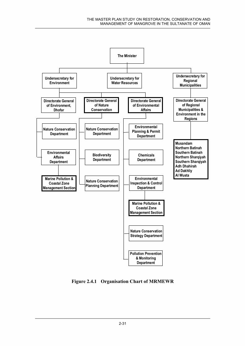
THE MASTER PLAN STUDY ON RESTORATION, CONSERVATION AND MANAGEMENT OF MANGROVE IN THE SULTANATE OF OMAN
2-31
Figure 2.4.1 Organisation Chart of MRMEWR
The Minister
Marine Pollution &Coastal Zone
Management Section
EnvironmentalAffairs
Department
Nature ConservationDepartment
Directorate Generalof Environment,
Dhofar
Directorate Generalof Nature
Conservation
Nature ConservationDepartment
Nature ConservationPlanning Department
BiodiversityDepartment
Undersecretary forWater Resources
Undersecretary forRegional
MunicipalitiesUndersecretary for
Environment
MusandamNorthern BatinahSouthern BatinahNorthern SharqiyahSouthern SharqiyahAdh DhahirahAd DakhliyAl Wusta
Pollution Prevention& MonitoringDepartment
Nature ConservationStrategy Department
EnvironmentalInspection & Control
Department
ChemicalsDepartment
EnvironmentalPlanning & Permit
Department
Directorate Generalof Environmental
Affairs
Marine Pollution &Coastal Zone
Management Section
Directorate Generalof Regional
Municipalities &Environment in the
Regions

Chapter 2 Existing Condition of Coastal Area in Oman
2-32
b. Local Government
There are 3 Governorates and 5 Regions in Oman. Under these Governorates and Regions, there are 59 Wilayats for local municipalities (Table 2.4.2). The administrative unit under Wilayat is locality. The Governorates are managed by Governors who are appointed by the Sultan, and the Wilayats by Walis. These Governorates and Wilayats have environmental sections. However, there are no staff for conservation and management for mangrove in these sections, because the Wilayat office is a practical organisation, not a planning organisation.
(a) International Organisations and NGOs
Oman is a member of the Regional Organisation for Protecting Marine Environment (ROPME), which was established by 8 countries, Gulf Co-operation Council (GCC) countries (Kuwait, Saudi Arabia, Bahrain, UAE, Qatar, and Oman), Iran, and Iraq. The objectives of ROPME are technical support and policy co-ordination for marine environmental problems. In Jan. 2003, Oman was declared the lead country for research into mangrove management in ROPME. The other members accepted this declaration. As of Jan. 2003, there are no donors and NGOs in operation for mangrove management in Oman.

THE MASTER PLAN STUDY ON RESTORATION, CONSERVATION AND MANAGEMENT OF MANGROVE IN THE SULTANATE OF OMAN
2-33
Table 2.4.2 Local Government System
No. Name Study Site No. Name Study Site1 Wilayat Mutrah 1 Wilayat Sur
1-a Murtafaat Al Qurm 5. Khawr Qurm 1-a Sur 8. At Tina,9. Batah
2 Wilayat Bawshar 1-b Ras Al Had 10. Khawr Quq,11. Khawr Hajar-East Shore
3 Wilayat As Seeb 2 Wilayat Ibra4 Wilayat Al Amrat 3 Wilayat Bidiyah5 Wilayat Muscat 4 Wilayat Al Qabil
5-a Al Khayran 6. Bandar Khayran 5 Wilayat Al Mudaybi6 Wilayat Qurayyat 6 Wilayat Dima Wa At Tayyin
6-a 7. Qurayyat 7 Wilayat Al Kamil Wa Al Wafi8 Wilayat Jaalan Bani Bu Ali9 Wilayat Jaalan Bani Bu Hasan
No. Name 10 Wilayat Wadi Bani Khalid1 Wilayat Sohar 11 Wilayat Masirah2 Wilayat Ar Rustaq 11-a 12. Wadi Muraysis3 Wilayat Shinas
3-a Tarif Al Makhamrah 1. Khawr Shinas4 Wilayat Liwa No. Name
4-a Harmul 2. Khawr Harmul/Nabr 1 Wilayat Hayma5 Wilayat Saham 2 Wilayat Muhut6 Wilayat Al Khaburah 2-a Falam 13. Filim-Easten Beach7 Wilayat As Suwayq 2-b Jazirat Muhut 14. Mahawt Island8 Wilayat Nakhal 3 Wilayat Ad Duqum9 Wilayat Wadi Al Maawil 4 Wilayat Al Jazer10 Wilayat Al Awabi11 Wilayat Al Musanaah12 Wilayat Al Barka No. Name
12-a Al Sawadi As Sahil 3. Khawr Sawadi 1 Wilayat Salalah12-b Al Haradi 4. Khawr Haradi 1-a 18. Khawr Dahariz
1-b 19. Khawr Balid1-c 20. Khawr Kabir
No. Name 1-d 21. Khawr Saghir1 Wilayat Khasab 2 Wilayat Thumrayt2 Wilayat Bukha 3 Wilayat Taqah3 Wilayat Daba Al Bayah 3-a Taqah 17. Qurm Taqa4 Wilayat Madha 4 Wilayat Mirbat
4-a 15. Al Demer Beach4-b 16. Khawr Rowri
No. Name 5 Wilayat Sadh1 Wilayat Al Buraymi 6 Wilayat Rakhyut2 Wilayat Ibri 7 Wilayat Dalkut3 Wilayat Mahdah 8 Wilayat Muqshin4 Wilayat Yanqul 9 Wilayat Shalim Wa Juzur Al Hallniyat5 Wilayat Dank
No. Name1 Wilayat Nizwa2 Wilayat Samail3 Wilayat Bahla4 Wilayat Adam5 Wilayat Al Hamra6 Wilayat Manah7 Wilayat Izki8 Wilayat Bid Bid
8. Governorate of Dhofar
3. Governorate of Musandam
4. Adh Dhahirah Region
5. Ad Dakhliyah Region
1. Governorate of Muscat 6. Ash Sharqiyah Region
2. Al Batinah Region
7. Al Wusta Region

Chapter 2 Existing Condition of Coastal Area in Oman
2-34
2.5 Zoning of Coastal Area
As a result of the survey on existing conditions covering geographical features, climate, wind/ wave and economic activity/ land use, it was decided that the study areas should be categorised into the following 5 zones Figure 2.5.1 shows the cross section of zones.
• Batinah Zone
• Muscat Zone
• Sharqiyah Zone
• Wusta Zone (including Masirah Island)
• Dhofar Zone
The characteristics of each zone are shown in Table 2.5.1.
Table 2.5.1 Characteristics of Each Zone
Zone Geographical Feature Climate Wind/ Wave Economic
activity/ Land use
Batinah Zone
Hinterland is wide plain, and relatively flat. Near the coast, it is relatively shallow, and the seabed is relatively gradual.
Hot and humid during the summer. Rainfall is infrequent and irregular.
Northeast wind in summer, southwest wind in winter. 40% wave frequency in summer, 30% in winter.
Agriculture, fishery. Farmland, populated residential area.
Muscat Zone
Hinterland is hilly, and relatively steep. Near the coast, it is relatively deep, and the seabed is relatively steep.
Hot and humid during the summer. Rainfall is infrequent and irregular.
Northeast wind in summer, southwest wind in winter. 40% wave frequency in summer, 30% in winter
Agriculture, fishery. Farmland, populated residential area.
Sharqiyah Zone
Hinterland is hilly, and very steep. Near the coast, it is deep, and the seabed is steep.
Hot and humid during the summer. Rainfall is infrequent and irregular.
South wind in summer, north wind in winter. 20% wave frequency in summer, 40% in winter.
Fishery. Mountain area, fishing villages
Wusta Zone
Hinterland is desert, and very flat. Near the coast, it is very shallow, and the seabed is almost flat.
Hot and humid during the summer. Rainfall is infrequent and irregular.
Very strong south/ southwest wind in summer, east wind in winter. 30% wave frequency in summer, 40% in winter.
Fishery. Desert area, fishing villages
Dhofar Zone
Hinterland is narrow plain, which is closed by mountain, and plain is relatively flat. Near the coast, it is relatively shallow, and the seabed is relatively gradual.
High humidity commonly Light monsoon rains in summer
North wind in summer, southeast wind in winter. 30% wave frequency in summer, 40% in winter.
Agriculture, fishery. Farmland, populated residential area.


Chapter 3: Value of Mangrove

THE MASTER PLAN STUDY ON RESTORATION, CONSERVATION AND MANAGEMENT OF MANGROVE IN THE SULTANATE OF OMAN
3-1
3. Value of Mangrove
3.1 Value of Mangrove in General
The value of mangrove forests can be categorised as shown in the following figure. The value is divided into two categories of “use value” and “non-use value”. The use value comprises direct value, indirect value and option value. The non-use value is usually the existence value. These values depend upon the people, in other words the social conditions and/or sites specific conditions.
In general, mangrove has some values as shown in the following figure. In case of Oman, the main value of mangrove is non-consumptive use value, indirect use value, and non-use value. Especially, the function of maintaining biodiversity is one of the most important values in Oman. From worldwide biological point of view, Oman plays very important role to connect wildlife between Africa and Asia. In this study, this point was considered carefully.
To implement the programmes and projects to be identified in the Master Plan, an understanding and agreement on the plan among Omani people and Government is indispensable. A valuation of mangrove ecosystems was carried out, as part of this study, to find out the most suitable use or conservation activities in this study.
Figure 3.1.1 Value of Mangrove Forest
3.2 Social Conditions Related to the Mangrove
According to the socio-economic survey at 10 sites, some situations common to all sites and some unique characteristics of individual site can be found as summarised as below. Also, the background conditions that might create such characteristics are observed and presumed by the local people.
Value of Mangrove Ecosystem
Use Value
Non-use Value
Direct Use Value
Indirect Use Value
Option Value
Consumptive Use
Non-consumptive Use
- Timber, Firewood- Agriculture resources- medicine- tourism and recreation- Educational, historic andscientific information- Genetic resourc- Storage and recyclingof human waste and pollutants- Shoreline/ riverbank- Maintenance of biodiversity- Provision of nursery andbreeding grounds for fish- Future Direct and IndirectUse value
- Cultural and aesthetic- Spiritual and religious

Chapter 3 Value of Mangrove
3-2
Table 3.2.1 Common Situations to be seen in All Sites
Item Situations Background that Create the Situation - Past 1-A. Fodder for camels and goats
2-A. Fuelwood for cooking 3-A. Construction wood for houses and ships 4-A. Fishing
- There were many mangrove trees. - A large number of fish were living.
Usage and Values - Present 1-A. Recreation (fishing, picnicking)
2-B. Hatchery of fish 3-B. Providing beautiful natural view
- Prohibition of use of mangroves by law for their protection.
- Green is attractive to the people. Resources - The number of fishes, crabs and shrimps
decreased. - The number of wild birds decreased. - The size of mangrove area has increased. - Condition of mangrove trees is not good.
- The khawrs become smaller. - Habitats of wildlife have been damaged. - The mangrove area is protected. - Trees are not well cared for such as
lopping. Impacts on the Living - The number of livestock animals
decreased. - Fishermen go to sea all year round.
- Mangrove cannot be used for fodder. - The khawr cannot be used because of
protection. Awareness - Many people know that mangrove grow
naturally. - Many people know the Nature Reserve
designation.
- Empirical knowledge with some relationship with mangroves.
- Governmental instruction and regulation are observed by the people.
Local Needs - Tourism development - People want to protect and extend the
mangrove area.
- Villagers expect benefits from development.
- They consider that natural green beauty is attractive to the local people and visitors.
Potentials The people are willing to join the activities by providing labour and advice.
Protection by the local people is important.
Note: A is for Direct Use, B is for Indirect Use/Value in column of “Usage and Values”
In the past, the mangrove ecosystems and khawr systems were utilised for multi-purposes and some of them were managed and controlled well by the local people to avoid over-utilisation. The changes of geographical condition due to less rain and flood, sedimentation, etc. and of the lifestyle, and legal control have limited the usage accordingly. Especially, since the use was stopped by regulations, people’s activities and feelings seem to have moved away from the mangrove areas and khawrs. While the people have recognized the changes in the area, some long for the past and feel a little bit uncomfortable about the present unutilised conditions. This is because most of the interviewees know the past conditions well. Most of the people hope for the expansion of mangroves in the area and are willing to be involved in the activities to be planned.

THE MASTER PLAN STUDY ON RESTORATION, CONSERVATION AND MANAGEMENT OF MANGROVE IN THE SULTANATE OF OMAN
3-3
Table 3.2.2 Unique Characteristics in Individual Site
Items Characteristics Site Background to Create the Characteristics - Materials for making Omani
cement Bandar Khayran -- Past
- Collecting honey Bandar Khayran/ Qurayyat
- Collecting honey Bandar Khayran/ Qurayyat
- Fishing using net Bandar Khayran/ Mahawt Island
- Browsing for goats Bandar Khayran/ Qurayyat/ At Tina/ Mahawt Island/ Qurm Taqah
- Browsing for camels Qurm Taqah
Usage and Values
Present
- No access by the people Khawr Kabir/ Qurm Taqah
- There are no income sources other than fishery.
- Livestock animals are free to feed themselves and owners do not care.
- Some mangrove areas are protected and surrounded by fence.
- The number of turtles has decreased and coral reefs have been damaged.
Wadi Muraysis/ Batah - Lack of environmental education and guidelines for coastal management to the local people. Resources
- Grasses grown around the khawr decreased.
Khawr Balid - Over-utilisation for fodder.
- Water quality has deteriorated. Khawr Qurm/ Qurayyat
- Wastewater and garbage are disposed of into the sea and khawr water level becomes lower.
- Mangrove area has decreased. Qurayyat - Overgrazing by goats and camels. - Management of trees is not enough.
Size and Quality
- Sedimentation is serious. Qurayyat/ At Tina/ Khawr Balid
- Harbour construction, dam construction, less rain are causes.
- Nobody knows the existence of plant nursery.
Khawr Qurm/ Khawr Kabir/ At Tina
- There are few opportunities to access the area and no information on the nursery.
- Local people try to stop illegal cutting.
Khawr Qurm - Local people have observed the regulation.
- When the mouth is open, the number of fish increases.
Qurayyat - People have empirical knowledge.
- Planting activities by school students.
Batah - The activities are well promoted.
Awareness
- Sheiks and the local people managed/controlled the area.
Qurayyat/ Wadi Muraysis/ At Tina
- The people knew the capacity of the mangrove and wanted sustainable use.
- Permanent open mouth of the khawr
Qurayyat - The people need more fish and mangroves previously.
- A bridge or a jetty from Filim to the Island
Mahawt Island - Low tide limits the people’s life. Local Needs
- The unemployed should be involved in the activities.
Batah - There are many unemployed young and need job opportunities.
- Information Centre is welcomed. Khawr Qurm - It will be tourism spot. - School participation is available. Khawr Shinas/ Bandar
Khayran/ Batah - School activities in the field are frequent.
- Monitoring of the area by the local people is required.
Wadi Muraysis - Inspectors visiting from other areas are not familiar with the area.
Potentials
- Monitoring of the areas by women is recommended.
Mahawt Island - Women have used the mangrove area more than men and know the significance of the mangrove ecosystem.

Chapter 3 Value of Mangrove
3-4
Among the above characteristics, positive ones can be made good use of to promote the activities of protection and management of the mangrove ecosystems, and for negative ones the ways of mitigation should be considered. The following table tries to find the measures to be taken, based on the results of the social survey. These information can be utilised for selecting transplanting sites and taking the conservation measures.
Table 3.2.3 Measures to Utilise the Advantages and Disadvantages
Characteristics Countermeasures Advantage • The frequency of recreational use of the
mangrove and the khawr ecosystem has increased.
• Activities of seedling planting have been done organised by MRMEWR.
• There are school activities in the field as environmental education.
• Women are very much involved in caring for mangrove area in some places.
• People appreciate the natural beauty of a green landscape.
• The local people know the Nature Reserve area and observe the regulation.
• Information on mangrove ecosystems and the importance of protection should be provided to the visitors by setting up signboards and distributing brochures, etc.
• Planting activities should be continued involving more local people, especially school students.
• School field activities should be utilised for this purpose, providing information on mangrove ecosystem to students as well as school staff and families.
• Women should be involved in the activities. • In order to attract more people to visit the
area, the way of protection should be considered (not just fencing the area but creating a nice atmosphere).
Disadvantage • The number of fish, turtles and birds has decreased.
• Conditions of mangrove trees are not good in spite of the area expansion.
• The existence of plant nursery is not known well among the local people.
• Still browsing by goats and camels is a problem in some places.
• The protected area is fenced and keeps the people away, which makes the people feel uncomfortable and uninterested in the mangrove ecosystem.
• In spite of many tourism development plans in various places, the involvement of the local people as beneficiaries is not promoted yet.
• Awareness level of the local people for the mangrove ecosystem varies from place to place.
• With population increase, urbanisation and motorisation, coastal area including mangroves gets impacts.
• Regulations and guidelines for protection of their habitats should be considered.
• Regular management by the local people should be considered such as trimming, cleaning and monitoring.
• Information on the MRMEWR activities should be disseminated widely.
• Guidelines for feeding livestock animals can be considered.
• Signboards and billboards explaining the mangrove ecosystem and importance of the protection (especially, the benefit to the people) should be set up and small facilities inviting the visitors should be considered.
• The local people should receive benefits through employment and other ways.
• Environmental education and enlightenment regarding mangrove should be flexible depending on the characteristics of the target groups.
• Regulation and education for public awareness are necessary.

THE MASTER PLAN STUDY ON RESTORATION, CONSERVATION AND MANAGEMENT OF MANGROVE IN THE SULTANATE OF OMAN
3-5
3.3 Value of Mangrove in Oman
3.3.1 Valuation Criteria
The valuation criteria set by the study are summarised in Table 3.3.1.
Table 3.3.1 Criteria of the Values of Mangrove
Criteria Value of Mangrove Ecosystem A; High potential
B; Medium potential
C; Low potential
N; No potential
1.1.1 Consumptive Use
Timber, Firewood, Agriculture resources, Medicine
Almost all families are
using
Half of families are
using
A certain number of
families are using
Almost all families are not using
1.1 Direct Use Value
1.1.2 Non- consumptive Use
Tourism and Recreation Educational, Historic and Scientific Information Genetic Resource
National level
(attraction for national
tourists)
Regional level
(attraction for regional
tourists)
Local level (attraction for local people)
No possibility
Storage and Recycling of Human Waste and Pollutants
Occurs in almost all
places
Occurs in many places
Occurs in some places
Does not occur
Shoreline/ Riverbank Protection
At storm control level
Against normal wind and waves
Against tidal erosion
No possibility
Maintenance of Biodiversity
National level
(mangrove area)
Regional level
(mangrove area)
Local level
(mangrove area)
No significant
value
1.2 Indirect Use Value
Provision of Nursery and Breeding Grounds for Fish
For regional economy
For supplement of income
For recreation
No possibility
1. Use Value
1.3 Option value Future Direct and Indirect Use Value
For regional economy
For supplement
of any income
For recreation
No possibility
2. Non-use value Cultural and Aesthetics (landscape) Spiritual and Religious
National level
(valuable/ rare for nation)
Regional level
(valuable/ rare for region)
Local level (valuable/ rare for
local area)
No potential
* There are many points of view on the evaluation of biodiversity. One of views is that there is a positive correlation between biodiversity and the size of mangrove area. In this study, the size of mangrove area is used as the evaluation criteria of biodiversity.
3.3.2 Value Recognised by Zone/Study Site and Management Direction
Based upon the socio-economic survey, the value of mangroves by zone is shown in Table 3.3.2, by study site in Table 3.3.3.

Chapter 3 Value of Mangrove
3-6
Table 3.3.2 Valuation of Mangrove Ecosystem by Zone
Zone Value of Mangrove Ecosystem
Batin
ah
Musc
at
Shar
qiyah
Wus
ta
Dhofa
r
1.1.1.1 Timber, Firewood N N N N N 1.1.1.2 Agriculture resources N C C N N
1.1.1 Consumptive Use 1.1.1.3 Medicine N N N N N
1.1.2.1 Tourism and Recreation B A A C A 1.1.2.2 Educational, Historic and Scientific
Information B A B B A
1.1 Direct Use Value 1.1.2 Non-
consumptive Use
1.1.2.3 Genetic Resource C C C C C 1.2.1 Storage and Recycling of Human Waste and
Pollutants N N N N N
1.2.2 Shoreline/ Riverbank C C C C C 1.2.3 Maintenance of Biodiversity A A A A A
1.2 Indirect Use Value
1.2.4 Provision of Nursery and Breeding Grounds for Fish
N C C B N
1. Use Value
1.3 Option value 1.3 Future Direct and Indirect Use Value N N N N N 2.1 Cultural and Aesthetics (landscape) C A B A C 2. Non-use value 2.2 Spiritual and Religious C C C C C
Legend: A; High potential, B; Medium potential, C; Low potential, N; No potential
Table 3.3.3 Valuation of Mangrove Ecosystem by Study Site
Zone Batinah Muscat Sharqiyah Wusta Dhofar
Value
of M
angr
ove E
cosy
stem
Khaw
r Shin
as
Khaw
r Har
mul/ N
abr
Khaw
r Saw
adi
Khaw
r Har
adi
Khaw
r Qur
m
Band
ar kh
ayra
n
Qura
yyat
At T
ina
Batah
Khaw
r Quq
Khaw
r Haja
r – E
ast S
hore
Wad
i Mur
aysis
Filim
– Ea
stern
Bea
ch
Maha
wt Is
land
Al D
emer
beac
h
Khaw
r Row
ri
Qurm
Taq
ah
Khaw
r Dah
ariz
Khaw
r Bali
d
Khaw
r Kab
ir
Khaw
r Sag
hir
1.1.1.1 N N N N N N N N N N N N N N N N N N N N N 1.1.1.2 N N N N N C C C C N N N N N N N N N N N N 1.1.1.3 N N N N N N N N N N N N N N N N N N N N N 1.1.2.1 B B A N A A B A A A A C C A C A C C A B A 1.1.2.2 A B A C A B A A A C C C C A C A B B A A A 1.1.2.3 C C C C C C C C C C C C C C C C C C C C C 1.2.1 N N N N N N N N N N N N N N N N N N N N N 1.2.2 C C C C C C C C C C C C C C C C C C C C C 1.2.3 A A B C A A A B A B B B B A C A B B B A A 1.2.4 N N N N N B C N N N N N N A N N N N N N N 1.3 N N N N N N N N N N N N N N N N N N N N N 2.1 A B C A A B A B B B B A B A C A C C A C C 2.2 C C C C C C C C C C C C C C C C C C C C C

THE MASTER PLAN STUDY ON RESTORATION, CONSERVATION AND MANAGEMENT OF MANGROVE IN THE SULTANATE OF OMAN
3-7
Mangrove in Oman comprises one species and also is spread on a very small scale. Therefore, the value of mangrove ecosystem in Oman is limited mainly to that of the resources for tourism/ recreation, education, heritage, scientific research, and the maintenance of biodiversity. Nonetheless, its value as greenery is particularly significant for this “desert country”. From the results of the valuation of the mangrove ecosystem, the basic policy on mangrove management was set.
In the Batinah Zone, mangroves play a role as a recreation site for residents, a source of educational information for residents/children, and as a biodiversity resource especially birds. The public parks adjacent to mangrove are used by residents at Khawr Shinas, and Harmul/Nabr, therefore the afforestation and management of mangrove is required. Khawr Sawadi is located near Sawadi Hotel, therefore the management and utilisation of mangroves as a tourism resource of mangrove are required. Coastal management, including pollution control, is required at Khawr Haradi.
In the Muscat Zone, mangroves play a role as a recreational site for tourism, not only national tourists but also international tourists, as a source of educational information for residents/children in Muscat City, a resource for biodiversity especially as a bird sanctuary, and as an element of the city aesthetics. Khawr Qurm, which is located at the heart of Muscat City, can be managed as a centre for educational information and place for the maintenance of biodiversity, possibly as a Ramsar Site. In Qurayyat, mangroves were managed by local people according to guidance from local Sheikhs. Based upon this historical fact, it is helpful if the mouth of khawr is kept open, therefore a training dike could be constructed. Mangroves in Bandar Khayran have the potential to support a fish nursery, therefore experimental afforestation for fishery could be considered.
The role of mangroves in Sharqiyah Zone is mainly for recreation for residents/ tourists, educational information for residents/ children, and a resource for biodiversity especially as bird sanctuaries. The mangroves at Batah are amongst the largest ones in Oman, so the protection and increase of mangroves are required. There are no mangroves at At Tina in Sur, and Khawr Quq and Khawr Hajar – East Shore at Ras Al Had. These sites have potential for mangrove growth, and maybe had mangroves in the past, afforestation is required for revival with special attention to protecting turtle habitat.
There are large-scale tidal flats in Wusta Zone. Mahawt Island has the largest mangrove area in Oman, and is the only site that appears to play a significant role in supporting fisheries. The mangrove at Mahawt Island might have the potential on the function of nursery of juveniles. It is better to have further study to clear up the relationship between the mangrove at Mahawt Island and the nursery of juveniles at Ghubbat Hashish which is located opposite side of Mahawt Island. This mangrove area should be kept as a symbol of mangrove in Oman. Careful management is required. Residents and government staff at Wadi Muraysis on Masirah Island and Filim have a strong willingness to plant mangroves. This is very important as an example of public participation.

Chapter 3 Value of Mangrove
3-8
The khawrs in Dhofar Zone are almost small scale and are often closed at their mouths. Therefore, the basic policy for coastal zone management in relation to mangroves is from the viewpoint of recreation and education for residents of Salalah City, and for the maintenance of biodiversity along with low level use as browse/ fodder for camels in sustainable basis with due consideration on conservation. For Al Demer Beach, further study of the sand dunes is required as a part of watershed management in Dhofar. The ecosystem at Khawr Rowri and Dahariz is intact, therefore any artificial activities are restricted. The adequate management for keeping existing ecosystem is required including the control of Prosopis julifora. Qurm Taqah, Khawrs Kabir and Saghir have existing mangroves, therefore management/ protection of the existing mangrove is required along with some planting. Khawr Balid, a site of archaeological importance, is located near the heart of Salalah City, recreational and educational function is expected. A centre for mangrove planting and garden can be considered.
The study sites are characterized mainly by the existence of mangrove and potential/ needs of mangrove plantation. Table 3.3.4 shows the characteristics of each khawr. The 21 study sites are divided in to 4 Types (Figure 3.3.1). Table 3.3.4 also shows the results of type classification.
Table 3.3.4 Type of the Khawr Site
No. Site Name Mangrove exist?
Potential and needs for mangrove plantation?
Remarks TYPE
1 Khawr Shinas Yes Yes Potential area in the north khawr TYPE 1
2 Khawr Harmul & Nabr Yes No No space for new plantation, Sand deposition on
mangrove vegetation TYPE 2
3 Khawr Sawadi No Yes Wide potential areas TYPE 3 4 Khawr Haradi No No Mouth of the Khawr is closed, No water in khawr TYPE 4 5 Khawr Qurm Yes Yes Plantation for QIC project TYPE 1 6 Bandar Khayran Yes Yes Potential area in front of fishery port TYPE 1
7 Qurayyat Yes Yes Sand deposition on mangrove vegetation, Plantation for training dike project TYPE 1
8 At Tina No Yes New plantation was already implemented by MRMEW TYPE 3 9 Batah Yes Yes Natural regeneration, Wide tidal area in front of vegetation TYPE 1 10 Khawr Quq No Yes Medium size tidal area TYPE 3
11 Khawr Hajar - East shore No Yes Wide tidal area TYPE 3
12 Wadi Muraysis No Yes Long coast and tidal zone TYPE 3
13 Filim – Eastern Beach Yes Yes Wide tidal area, poor natural regeneration TYPE 1
14 Mahawt Island Yes No Coastal area mostly covered by natural vegetation TYPE 2 15 Al Demer No No Sand protection area TYPE 4 16 Khawr Rowri No No World heritage, potential area only on the sand bar TYPE 4 17 Qurm Taqah Yes ○ Very small area TYPE 1
18 Khawr Dahariz No No Mouth of the Khawr is closed, Small potential area near khawr mouth, but in danger of flash flood TYPE 4
19 Khawr Balid No Yes World heritage, plantation for a new project TYPE 3 20 Khawr Kabir Yes No Already planted by MRMEW in a potential area TYPE 2 21 Khawr Saghir Yes No Already planted by MRMEW in a potential area TYPE 2

THE MASTER PLAN STUDY ON RESTORATION, CONSERVATION AND MANAGEMENT OF MANGROVE IN THE SULTANATE OF OMAN
3-9
Figure 3.3.1 Types of the Khawr Site
TYPE 3
Mangrove planting project
TYPE 4
Coastal managementproject (Water pollution &solid waste managementprogramme/ Study on sanddune/ Land use controlplanning project/ Bird hidearrangement project)
TYPE 2
Mangrove maintenanceproject
TYPE 1
Mangrove planting project(including existingmangrove maintenanceproject)
Mangrove exist ? Potential and needs formangrove plantation ?
Potential and needs formangrove plantation ?
YES
YES
YES
NO
NO
NO

Chapter 4: Issues and Strategy

THE MASTER PLAN STUDY ON RESTORATION, CONSERVATION AND MANAGEMENT OF MANGROVE IN THE SULTANATE OF OMAN
4-1
4. Issues and Strategy
4.1 Introduction - Protective and Creative Management of Mangroves
Mangroves, Avicennia marina, have grown on the coast of Oman for many thousands of years. Historically, they have provided browse for livestock, fuel-wood, timber for building and stems for various crafts, including baskets used for fishing activities. These uses are generally declining due to increased wealth and the availability of gas for cooking. Though it is evident that their distribution, abundance and condition have been affected by sedimentation, climate and sea level change and the activities of man and his livestock, this species has survived at many locations to the present day without any supporting interventions (such as planting) from the human population.
The only form of “traditional” conservation/resource management that has been identified by the JICA study, took place at Qurayyat in the 20th Century (possibly earlier) up until about 40 years ago. Several leaders of the local communities in Qurayyat, especially those in the districts near to the Khawr, would monitor the condition of the mangrove. According to their advice, and perhaps three times per year, the Wali would authorise a public announcement allowing the local people to exploit the mangroves. As a result, local people would harvest living and dead mangrove stems (as a fuel for cooking, as fodder for livestock, for use in local crafts and possibly in construction), for a given period of time (e.g. 2 to 5 days).
As described in section 4.2, modern development, has brought other pressures, especially from urban, industrial, and recreational activities, port and harbour construction and the risk of oil pollution and eutrophication of enclosed waters - while some of the original pressures have continued, to a greater or lesser extent. Thus, in recent times, the mangroves have, at various locations, been subject to the negative effects of rapid development. For example, in northern Oman, the construction of coastal infrastructure and recreational facilities (see sections 4.2.1 and 4.2.2) does appear to have had some affect on mangrove ecosystems. Then in Dhofar, mangroves have been damaged by more intense browsing by camels, as well as the lopping of branches by the camel-owners, as a result of increased camel numbers and of traditional pastoral areas being lost both in the mountain and in the Salalah plain to the expansion of Salalah.
Nevertheless, if mangroves and their surrounding environs are “left alone” (i.e. are not subject to poorly planned or executed development activities and are protected from livestock), the general evidence suggests that little or no active management is required to ensure their continued survival.
However, the current situation in Oman is that many natural habitats, including those of mangrove lagoons and other khawrs (khayraan), are subject to damage from rapid development; they are not being “left alone” and thus active management measures

Chapter 4 Issues and Strategy
4-2
are essential. In particular, protective management measures are required to manage/ control those development activities, in order to minimise their impact. In addition, creative management measures (such as the rearing and planting of mangrove seedlings) are also necessary in order (i) to mitigate existing damages and (ii) to create new mangrove habitats for their support to the conservation of biodiversity and for their direct and indirect role in providing exploitable natural resources.
Therefore, in simple terms, the overall strategy for the “restoration, conservation and management of mangroves” has two separate approaches:
• Protective Management Measures that ensure the security of existing mangrove ecosystems from inappropriate development activities and management practices;
• Creative Management Measures that create new mangrove ecosystems at appropriate locations, and that enhance existing mangrove ecosystems, primarily by planting of mangrove seedlings.
Furthermore, it is dispensable for institutions and personnel to be able to carry out effective protection and creation activities for mangrove habitats. Therefore, some Supporting Measures to rectify the lack of trained Omani personnel and to provide easy-to-use information storing/ sharing systems and other facilities, and so on are also required to deal with these issues.
This chapter therefore sets out some of the main Issues facing mangrove ecosystems in Oman today, for which either Protective Management Measures and/or Creative Management Measures will be needed, along with various Supporting Measures. Strategies are proposed that will guide actions to address those issues.
4.2 Protective Management Measures for Mangroves
4.2.1 Protection Against Coastal Development
a. Port and Harbour Construction - Coastal Erosion and Sedimentation Issues
The introduction of a solid structure, such as a harbour wall or breakwater, to an open, sandy coastline such as that of the Batinah, can affect the natural movement and deposition of sand along its beaches. The change to coastal processes caused by such a structure can lead to accretion or erosion of sand along nearby beaches. Where the beach includes the mouth of a mangrove lagoon, the changes to the pattern of deposition and erosion of sediments may have a big impact on the mangrove ecosystem. An example can be seen at Khawr Harmul at Liwa, one of the few mangrove sites along the Batinah coast. Following the construction of the port at Sohar 2.5 km to the southeast, severe beach erosion has occurred at Sah Harmul village and deposition of sediment has taken place at the mouth of Khawr Harmul, such that the mouth had moved 200-300m by May 2002 (Figure 4.2.1). Though these changes may in part be due to natural processes and the mangrove trees did not appear to have been affected by July 2003, the

THE MASTER PLAN STUDY ON RESTORATION, CONSERVATION AND MANAGEMENT OF MANGROVE IN THE SULTANATE OF OMAN
4-3
changes to the morphology and hydrology of the khawr may threaten long-term survival of the mangroves.
Figure 4.2.1 Location of where the mouth of Khawr Harmul has moved following construction of Sohar Port
Another example of a mangrove site probably affected by a similar coastal development is provided at Khawr Qurayyat (Khawr Al Hajar). Here the mangrove khawr mouth had been closed for several years and only recently (May 2003) was it opened by a flood from the wadi (and it was still just open in January 2004), but appeared likely to close in the next few months without another major flood. The lack of connection to the sea had led to a decline in the condition of some of the mangroves, a fall in populations of marine species and stagnation of the water. A similar process of increased sedimentation, to that observed at Khawr Harmul, may be responsible for the problems at Khawr Qurayyat (Al Hajar), due to the construction of the new port at Khawr As Seerah, 1.8 km to the southeast.
b. Road Issues
New roads have various direct and indirect impacts on the environment. The direct impacts include the loss of natural habitats and the damage to Oman’s dramatic landscape; these, and the air and noise pollution produced by traffic, are of particular significance in potential tourism sites. Then there is the indirect impact that arises from increased human access to coastal habitats. Fishing, garbage, disturbance of
Khawr Harmul Shoreline Evolution (top; Feb 1998 :Before Construction of Sohar Port)
Coastal Development (bottom; May 2002 –
after construction of Sohar Port)

Chapter 4 Issues and Strategy
4-4
wildlife, illegal hunting and cutting of trees can all increase, with negative consequences for the environment.
One mangrove ecosystem, Khawr Qurm near to Muscat, has already been damaged by the construction of the coastal road and bridge linking Qurm Street and Shati Al Qurm. Though there have been clear socio-economic benefits (in that this stretch of coast has become very popular as a recreational area for Omanis and international visitors), one of the best examples in the Muscat area of coastal dune vegetation has been lost and the wading birds, which were once abundant on the shore, are now disturbed by the large numbers of visitors to the beach.
Two mangrove ecosystems are currently threatened by roads (Figure 4.2.2). Bandar Khayran is on the route of the new coastal road linking Muscat to Qurayyat. The environmental impact assessment (Atkins, 2003) for Muscat Municipality recommends taking the route inland behind the mountains at Bandar Khayran to avoid the coast altogether. This would leave the quiet bay, mangroves and natural landscape largely intact, with access still possible via a graded road and by boat. Nevertheless, whichever route is selected, the access to the area will be improved and as the numbers of tourists to Oman increase, impacts from increasing numbers of visitors to the area will still be felt.
a. Bandar Khayran – the existing graded road may be replaced by a larger coastal road,
b. Filim to Mahawt Island - a new road/causeway has been proposed.
Figure 4.2.2

THE MASTER PLAN STUDY ON RESTORATION, CONSERVATION AND MANAGEMENT OF MANGROVE IN THE SULTANATE OF OMAN
4-5
The mangrove ecosystem at Mahawt is the other location where a potentially damaging road has been proposed - connecting Mahawt Island to the Mainland. The road, especially if constructed on a causeway, would change the seawater current system of the bay with potential impacts on the rich shrimp and fish nursery grounds. Equally, if not more significant, the road would change the fundamental interest of the island – it would no longer be an island! The road would give easy and free access to all and large numbers of visitors could easily pollute and damage the delicate island ecosystem, which contains the best developed and most diverse mangrove ecosystem in Oman.
c. Strategy for Protection from Coastal Development
The best approach to preventing unnecessary damage to mangrove ecosystems from the development of roads, breakwaters and other facilities along the coast is strict adherence to the Sultanate’s Environmental Impact Assessment legislation and procedures. Before projects are approved, comprehensive feasibility and EIA studies should be undertaken, to ensure that the only projects to proceed are those that are sound from the technical, social, economic, financial and environmental aspects. Where a project is fully justified in order to promote the sustainable development of the country, but environmental impacts are inevitable, every effort should be made to adopt effective mitigation measures.
Coastal zone setbacks as approved in Ministerial Decision 20/1990 of the Supreme Council for Town Planning should also be followed.
4.2.2 Protection Against the Impacts of Tourism and Recreation
a. Tourism and Recreation Issues
Mangrove ecosystems can suffer directly and indirectly from poorly located tourism and recreation facilities. Examples of direct damage to mangroves by “reclamation/ landfill” (earth and rock being bull-dozed onto mangrove habitat) can be seen at Khawr Shinas (Figure 4.2.3) and Khawr Harmul near Liwa, where picnic sites have been constructed too close to the edge of the mangrove trees – and at Khawr Shinas some mangrove trees had been removed to make way for a small foot-bridge. This mangrove-edge habitat, which is normally rich in invertebrate life, has been lost and the solid fill material may affect the flow of water in the channel.
Similarly, at Khawr Balid in Dhofar, the development of the historical elements of the Frankincense Trail World Heritage Site for visitors, which is highly commendable, has been accompanied by the wholesale removal of natural vegetation along a significant part of the banks of the Khawr. Natural dune vegetation, which should protect the coast from erosive waves in the monsoon, has also been removed. Such “management” has been carried out as a “cleaning” landscaping exercise, but is ecologically damaging and is not essential for visitors to enjoy the natural aspects of such sites.

Chapter 4 Issues and Strategy
4-6
Figure 4.2.3 Khawr Shinas – environmentally damaging and unsafe construction of a bridge, illustrating need for better design of footpaths and other facilities
b. Tourism and Recreation Strategy
The MRMEWR in principle welcomes the interest of local people, tourists and scientists in mangroves and mangrove ecosystems, and wishes to encourage visitors to explore, enjoy and learn about this interesting and unusual environment in such a way that does not cause them any damage. Management Plans and Technical Specifications, that support the maintenance of mangrove and other khawr ecosystems in a natural state and do not permit up-rooting, covering with rocks/fill material or similar damage to native vegetation, should be adopted and adhered to.
Only in exceptional circumstances and if there is very good reason as set out in the management plan (e.g. the installation of a boardwalk and bird observation hide) should infrastructure require the destruction of mangroves or other natural vegetation/habitats close to the site (<150 m). A setback of at least 150m should be observed for such developments to prevent encroachment onto the mangrove areas.
4.2.3 Protection from Solid Waste and Water Pollution
a. Solid Waste and Water Pollution Issues
Prior to Oman’s renaissance, much of the solid waste produced from traditional activities and households neighbouring khawrs was small in quantity, re-used in some way or was biodegradable. Modern Omani society produces much more solid waste, including many durable materials such as plastics, metals, concrete and other building materials. Despite the best efforts of the MRMEWR to collect and dispose of this waste in a safe way, some of this material (especially near urban areas) reaches the khawrs and can be found entangled in mangrove trees, in the water, on the mud and on the banks; most of this waste is believed to be non-hazardous. Some of the waste has been thrown directly into the mangrove areas, other waste has been disposed of in the wadis upstream and been washed into the khawr during a flood. The waste can pose a threat to wildlife, to livestock feeding in and near the mangroves and is very unsightly – this is highly undesirable for those mangrove sites where recreation and tourism are being encouraged.

THE MASTER PLAN STUDY ON RESTORATION, CONSERVATION AND MANAGEMENT OF MANGROVE IN THE SULTANATE OF OMAN
4-7
There is a risk of raised nutrient levels in enclosed lagoons that are bordered by housing, agriculture or other developments as at Sur and Hajar (Ras Al Had). Leakage, into the lagoon system, from sewage tanks of houses and hotels may lead to small changes in nitrate and phosphate levels and increased growth of algae, which can cover mud surfaces and young mangroves. When these algal mats eventually die they decompose, using up oxygen in the water and so killing many of the animal species. The presence of mats of blue-green algae in such lagoons indicates that nutrient levels are already high. There are signs of significant algal growth in the Khawr at Sur, smothering young mangrove seedlings, which may not survive unless the algal mats are removed (Figure 4.2.4).
Figure 4.2.4 Blue-green alga Lyngbya majascula smothering young mangroves at Sur; a sign of eutrophication
b. Solid Waste Management and Water Pollution Strategy
To help keep mangrove ecosystems in healthy condition and free of pollution from solid and liquid waste, the overall strategy is to raise knowledge, understanding and awareness among citizens and government officials of the value and sensitivities of mangrove ecosystems, and the threats to them, so that improvements can be made to the planning and management of development activities in these areas. The water quality monitoring at Batah in Sur is already started by local government. It is necessary to continue this programme. The strategy can be implemented through taking some of the following, and other, steps (and strengthened where initiatives or programmes are already in place):
• Agreement of responsibilities for monitoring and clean-up of khawrs (MRMEWR to play a lead role, but other organisations can be expected to support).
Sur. Water pollution. Blue-green alga Lyngbya majascula and high coliform bacteria counts.

Chapter 4 Issues and Strategy
4-8
• Regular inspections by MRMEWR staff, e.g. to evaluate solid waste problems, arrange clean-up and deter illegal dumping.
• Education campaigns to encourage industries, retailers and citizens to reduce the amount of solid waste they produce and to dispose of it correctly.
• Cleaning campaigns, e.g. in Municipalities Month, focusing on mangrove sites.
• Scientific monitoring (e.g. water quality) to understand better the problem.
• Prevention of house construction and similar urban developments close to mangrove and other lagoons/khawrs.
• Where houses and similar urban developments are already close to mangrove and other lagoons/khawrs, domestic wastewater should not be discharged directly or indirectly into the surface water or groundwater.
• In mangrove and other coastal areas, those responsible for urban planning, issuing building permits and enforcing building regulations (especially in relation to septic and holding tanks) should be encouraged to pay close attention to the sensitivities of mangrove ecosystems to water pollution to ensure that plans, designs and implementation do not contribute to pollution/eutrophication of the ecosystem.
4.2.4 Sustainable Utilisation of Mangroves and Mangrove Ecosystems (including Fisheries) and Biodiversity Protection
a. Sustainable Utilisation and Biodiversity Conservation Issues
Mangrove ecosystems are still particularly vulnerable to damage from the various “use” and “non-use” activities of humans and their livestock, especially when located near towns and villages. Khawr Qurayyat is an example showing, on the landward fringe, encroachment from date palm plantations, tracks and football pitches – the latter to the south-west of the mangroves and the khawr, on an area that is now sabkha. On the south-east side, the mangroves adjacent to the main settlement, near to the coast have been subject to heavy browsing by goats. Recreational fishing, in the khawr, also takes place.
However, on a small-scale, mangroves are of direct benefit to livestock owners as the leaves and fruit provide good fodder for goats and camels; but the trees are easily “overgrazed” as can be seen in Dhofar (Figure 4.2.5), where browsing animals also prevent seedling regeneration. In a similar way, small-scale “fishing” is possible in the mangrove areas, with exploitable species including milkfish, mullet and invertebrates, especially crabs and molluscs (e.g. oysters and Terebralia palustris, the mud snail, a large gastropod). However, over-exploitation is a threat to some species such as the Mangrove crab (Scylla serrata), which has become quite rare in many khawrs.

THE MASTER PLAN STUDY ON RESTORATION, CONSERVATION AND MANAGEMENT OF MANGROVE IN THE SULTANATE OF OMAN
4-9
Figure 4.2.5 Camels at Khawr Taqah; a clear browse line is visible
Finally, it has been found that young mangrove stems are used, on a small scale, in local crafts, especially at Qurayyat. They are used in the making of the “mahlaq”, a basket used by fishermen for taking live bait on fishing trips (Richardson, N. and Dorr M., 2004, The Craft Heritage of Oman, Motivate Publishing, Dubai. ISBN 1-86063-157-6); they can also be used in the making of the traditional Omani drum or “ţubl”, where they form the internal rim (Shawqi, Yusuf, 1994, Dictionary of Traditional Music in Oman, Florien, Noetzel Verlag, Wilhelmshaven, Germany. ISBN 3-7959-0674-1). For both uses their flexibility is considered to be important and in the “mahlaq” their tolerance of salt water.
Since these uses can be sustainable and contribute to local livelihoods and demonstrate the value of mangroves, they should be encouraged – but in a non-conflicting way, i.e. one sustainable use should not conflict with another, including the use of the mangrove ecosystems as a wildlife resource for tourism, education and scientific research.
This leads to the “biodiversity value” of mangrove ecosystems in general and of some sites in particular; key elements of the flora and fauna associated with mangroves in Oman have been summarised in section 2.1.4 and further details of each site are given in Part 2 (Appendix 1. Study Area and Field Survey) and Vol. 2 (Technical Specifications of Sites). Several sites have been declared Nature Reserves (Khawr Qurm in Muscat and several Khawrs in Dhofar) and another site (Mahawt, as part of Barr Al Hikmann) has been proposed for declaration. Other sites would also benefit from legal protection, especially Shinas and Bandar Khayran; these, and Mahawt (Figure 4.2.6), are all outstanding examples of mangrove ecosystems in their regions and are vulnerable to the impacts from nearby developments, existing and proposed. Shinas and Mahawt provide important habitat for threatened species of birds. The small island of Muraysis, on the west coast of Masirah, is also an important conservation site (Figure 4.2.6); this is primarily for the large numbers of sea-birds that nest there, but it also has a small population of mangroves. It is biodiverse sites such

Chapter 4 Issues and Strategy
4-10
as these that have eco-tourism potential; eco-tourism and other sustainable use opportunities need to be recognised in legal protection measures and management plans.
Figure 4.2.6 Jazirat Muraysis (top) has mangroves and a large population of breeding birds, while Mahawt Island (bottom) has extensive mangroves and is rich
in invertebrates. Both have potential for eco-tourism.
However, it must be emphasised that though the legal declaration of a mangrove site as a Nature Reserve and the approval of a management plan may in theory offer a site and its biodiversity some protection from inappropriate use and development, it is only the first step in ensuring sustainable management. As long as pressures from man and his livestock remain, active management measures, both protective and creative, will still be required.
Finally, there is one issue that all the various aspects of mangrove utilisation and conservation have in common and that is co-ordination – or rather lack of

THE MASTER PLAN STUDY ON RESTORATION, CONSERVATION AND MANAGEMENT OF MANGROVE IN THE SULTANATE OF OMAN
4-11
co-ordination. Many settlements and much of Oman’s population, including Muscat and Salalah, are concentrated within the coastal zone. Many Ministries and other government agencies, including the various parts of the MRMEWR, have projects and responsibilities here and the citizens have their own interests and activities to pursue, such as fishing, livestock rearing and recreation. Some of these projects and activities, unless carefully planned and managed, have been and will be in conflict with each other and may threaten the health of the mangrove ecosystems. There is a clear need for improving the communication and co-ordination between these “stakeholders” to ensure a sustainable future for Oman’s mangroves.
b. Strategy for Sustainable Utilisation and Conservation of Biodiversity
The strategy for “Sustainable Utilisation and Conservation of Biodiversity of Mangrove Ecosystems” has three main components:
(1) Legal Protection/Declaration of Nature Reserves.
(2) The Preparation of Management Plans/Technical Specifications.
(3) Communication between and Co-ordination of Stakeholders
For those mangrove sites without existing legal protection, they should be declared as Nature Reserves under the responsibility of the MRMEWR, though responsibility for management could be assigned by the MRMEWR to another responsible government body or a non-government organisation that is active in environmental conservation.
Management Plans for each site should be prepared, discussed and agreed with other stakeholders (see next paragraph) and approved by the MRMEWR. The Technical Specifications for each site, prepared by this JICA Study (see Supporting Report), should provide the basis for the Management Plans. The Management Plans will establish “systems” for permitting sustainable utilisation of mangroves and of the other resources that they support. The utilisation may take the form of permitting specified harvesting activities to be carried out in certain sections of the mangrove habitat for an agreed period of time. These activities would have to be determined on a site by site basis and at some sites (or parts of a site), where biodiversity conservation is a priority, that no consumptive-uses (or even non-consumptive uses) will be permitted. The Management Plans will need to specify responsibilities for operating the “systems” and for monitoring their application and impact/effectiveness.
The MRMEWR will seek to improve the Communication and Co-ordination between the various stakeholders with interests in mangrove ecosystems or activities that may affect them in order to achieve integrated and sustainable development. At a national level MRMEWR will seek to inform and co-ordinate with the planning and project departments within each Ministry that is involved in developments in the coastal zone, and at a regional level MRMEWR will seek to exchange information and co-ordinate with local stakeholders. It is expected that the proposed Qurm Environmental Information Centre (QEIC) will play a key role in establishing and carrying out these Communication and Co-ordination functions (see section 4.5.2 for further details).

Chapter 4 Issues and Strategy
4-12
4.3 Planting Issues and Strategy
4.3.1 Conservation of Existing Mangroves
a. Issues
For Oman’s existing mangroves and mangrove ecosystems to be maintained in a healthy condition, the most cost-effective approach should be the application of protective management measures as presented in Section 4.2. However, if an existing mangrove ecosystem has been damaged in some way, such that areas of mangrove trees have been damaged or lost completely, then consideration should be given to planting mangrove seedlings to replace those damaged or lost. At such locations there may also be scope for planting “new areas” with mangroves (i.e. parts of a lagoon at which mangroves are not known to have been present for many years), as compensation for the trees and ecosystems that have been damaged and lost.
b. Strategy
Priority will be given to the protection of the existing mangroves and mangrove ecosystems. The planting of mangrove seedlings should normally be undertaken only in those “locations” where they will replace mangrove trees that have been damaged or lost and it is believed that this will help to accelerate significantly the natural regeneration of the population. Where the “location” is a lagoon or other coastal habitat that has “areas” with and without mangroves, consideration should also be given to planting mangrove seedlings in “new areas” where it can be shown that this should enhance the lagoon ecosystem without damaging other features of value in terms of biodiversity and wildlife conservation.
4.3.2 New Plantations
a. Issues - Location
There are various locations on the coast of Oman where mangroves do not grow at present, but where it may be possible for seedlings to be planted and for them to survive and even thrive, reproducing naturally to establish a self-sustaining population without need for further planting.
Some of these locations may correspond quite closely to sites where evidence has shown that mangroves used to grow hundreds or thousands of years ago (e.g. 6,000 years B.P. at Suwayh south of Ras al Had), but have died out due to natural causes (climate and sea level changes) and/or the impacts of man and his livestock.
At other locations considered for planting by the JICA Study Team, e.g. at Hammar Muraysis, on the main island of Masirah, opposite to Jazirat Muraysis, mangroves may "never" have grown, at least not in the last 10,000 years or so. However, with man's

THE MASTER PLAN STUDY ON RESTORATION, CONSERVATION AND MANAGEMENT OF MANGROVE IN THE SULTANATE OF OMAN
4-13
intervention (planting and protection) they may be able to survive at these locations and there may be good reasons to attempt to establish plantations.
With limited financial and human resources available, a strategy is required to give guidance on the priority to be given to planting activities and the criteria MRMEWR should apply for selecting such locations.
b. Strategy - Location
Though priority will be given to protecting and restoring existing mangrove ecosystems at locations where the success rate of any planting should be high (since the natural conditions are known already to be suitable for the growth of mangroves), the MRMEWR will also make efforts to promote and assist the establishment of new plantations at locations where the following conditions apply:
• Local interest and support for plantation of mangroves (including both the local community and authorities, e.g. Municipality, Wali, Agriculture and Fisheries).
• The plantation will be of landscape/amenity value for local citizens and visitors.
• The location is such that the mangroves should make a positive contribution to the biodiversity and natural resources of the proposed site or region.
• That the physical conditions (soil, water, shelter etc) are suitable.
• That a neighbouring supply of mangrove seeds will be used.
• The site is accessible enough for planting to proceed at low cost.
In evaluating locations and proposals, MRMEWR shall pay particular attention to local interest and support, even to the extent that sub-optimal planting sites may be considered - provided MRMEWR mangrove experts believe there is a reasonable chance (e.g. >50%) of success.
c. Issue - Use of Indigenous Species
There is only one species of mangrove, Avicennia marina, that can be considered native to present-day Oman, though there is good evidence that another species, Rhizophora mucronata, occurred here in the past (6,000 years B.P. at Ras Al Had); Rhizophora does still occur on the coasts of Yemen and Iran. Research has indicated that the disappearance of Rhizophora from Oman was caused by a change in climate, possibly accelerated by the activities of man. Though the introduction to Omani ecosystems of Rhizophora might not pose a threat to the native flora and fauna of Oman, in the way that the introduction of the mesquite tree, Prosopis juliflora (a native of the Americas), has posed a threat, the introduction of Rhizophora is hard to justify. Environmental conditions have changed and the protection and management of existing strands of Avicennia marina, and of other native ecosystems, should be a much higher conservation priority.

Chapter 4 Issues and Strategy
4-14
d. Strategy - Use of Indigenous Species
In all mangrove planting schemes, only the species native to Oman, Avicennia marina, should be used.
e. Issue - Seed Provenance
It is the understanding of the Study Team that the mangrove trees in the Batinah and Muscat zones of Oman usually flower only once per year (typically April-June at Khawr Qurm and Bandar Khayran), while the mangroves in the Dhofar zone may flower twice per year (in June-July and again from November to January). This difference would appear to be an adaptation to the climatic regime prevailing in Dhofar being very different to that found in central and northern Oman. However, some trees in Sharqiyah and Al Wusta are reported also to flower twice per year, so the situation is not entirely clear. The Dhofar mangrove trees may also have other, less obvious, adaptations to the differences in environmental conditions between Dhofar and the rest of Oman. Such adaptations may have a genetic basis, i.e. the populations in Dhofar may have evolved into a slightly different “race” or “ecotype”, such that they might also flower twice a year if transplanted to northern Oman - but this has not yet been established.
There may also be small, genetic differences between the mangrove populations found in the other zones, and even within the different lagoons/khayraan within a single zone, given that Avicennia marina is insect pollinated and that the populations are quite isolated from each other (some are separated by over 50 km from the next population). In theory, any genetic differences might correspond to environmental adaptations by the mangroves, e.g. to slightly different salinity regimes in Khawr Qurm in Muscat (which is subject to regular surface and sub-surface freshwater flows) when compared to Filim and Mahawt, where the influence of freshwater flows would appear to be low and very occasional. On the other hand, Avicennia marina is one of the few species of higher plant that are adapted to a very extreme and variable environment (saline water and daily tides). Therefore, any variability (between populations), in their genetic adaptation to different local environments within Oman, may be almost insignificant in comparison to the species’ overall adaptation to its extreme and variable coastal environment.
Only detailed research into genetic and phenotypic variation, including DNA analysis, is likely to resolve this issue of the extent of genetic variation of the various Omani mangrove populations. In the meantime, it would be advisable for MRMEWR to adopt the “precautionary principle” in its planting programmes. In case mangroves from one locality/population are not so well-adapted to another locality in Oman, seed of the most “local” origin should be used when planting seedlings at any site. If local seeds are not used, there is a small risk that the new seedlings and adult trees may not thrive, and may “contaminate” mangroves of local origin that are better adapted to that local environment.

THE MASTER PLAN STUDY ON RESTORATION, CONSERVATION AND MANAGEMENT OF MANGROVE IN THE SULTANATE OF OMAN
4-15
f. Strategy - Seed Provenance
The guiding strategy for seed collection and use in planting programmes is for "local" seed to be selected.
• For sites where mangroves already exist, the seeds for planting should be collected from that site.
• For sites where there is no mangroves, the seeds for planting should be collected from the nearest existing mangrove site.
g. Mangrove Nurseries - Issues and Strategy
Since the strategy is to use local seed wherever possible, it should not be necessary to have large, permanent nurseries in each of the five zones. These are costly to construct and operate and seedlings may have to be transported considerable distances to planting sites. Temporary nurseries should therefore be established at those sites where planting will take place, with seed being transported from the nearest source. In case the sites are located in remote places, direct sowing of seeds in an alternative method to be considered.
4.4 Management Activities at Mangrove Sites
4.4.1 Monitoring
a. Monitoring Issues
Recognising the value of mangroves as described in Chapter 3, it is necessary to ensure that management activities, both protective measures and creative measures (planting), are proving successful. Therefore a monitoring programme is required that, ideally, can achieve the following:
• Detect immediate threats or damage to mangroves and mangrove ecosystems, so that rapid action can be taken to counter the threat and any potential or actual impacts.
• Detect early warning signs of longer term threats or changes to the mangrove ecosystem.
• Assess, on an ongoing basis, the success or otherwise of planting activities.
• Assess progress in the implementation and effectiveness of other management activities.
In addition, it is highly desirable that, whatever monitoring methods and personnel are used, they are cost and time-effective and do not constitute an unnecessary drain on the limited technical and financial resources of the MRMEWR.

Chapter 4 Issues and Strategy
4-16
Identifying personnel who will be willing and capable of undertaking the various monitoring tasks is a key issue. As a matter of principle, it is believed that local people and non-government groups should be encouraged to participate in such activities as much as possible (and preferably on a voluntary basis), so that local interest in the conservation and “ownership” of mangrove ecosystem resources is promoted.
b. Monitoring Strategy
To detect immediate and visible threats to the khawrs with (and without) mangroves a programme of frequent visual inspections should be developed. Depending on location of the Khawr/Mangroves in relation to MRMEWR offices, staff accommodation and that of other potential observers, these could be daily or weekly inspections, i.e. will have to be developed on a site specific basis. Rangers of the Directorate-General of Nature Conservation should play a role in monitoring, where this can be incorporated into their existing activities. At sites distant from local MRMEWR offices, not covered by rangers and if funds are available, the appointment of local guards (who live very near to the mangrove ecosystems) for a few hours a week could be considered. They would look for signs of illegal activity (cutting without a permit), damage, pollution and record any significant natural events (floods, very high tides, periods connected to and separated from the sea etc.).
The detection of longer term threats or damage to mangroves and mangrove ecosystems and their causes will be difficult, because the changes may be taking place slowly (over a number of years) and it can be difficult to distinguish whether changes are due to natural variation or man-made impacts. Negative impacts on a mangrove system may also take many years to show themselves and repeated site visits may be needed to detect them. For this reason it is important to have a good baseline and to collect data over several years, so that trends in the flora and fauna can be followed.
The desired monitoring should therefore consist of regular visits to selected mangrove ecosystems once or twice a year (summer and winter) to record the condition of selected mangrove trees and the numbers of the different plant and animal species, in order to provide a picture of their “normal” condition/status at each site. The easiest organisms to use for monitoring are members of the macro fauna, namely birds, crabs and molluscs. The flora can also be monitored to check the condition of the vegetation whether grazed, cut or disturbed in some way. The water quality and any indication of pollution should also be reported.
The use of indicator species is one way to determine the health of an ecosystem. However, this means that the relationship between the species or group of species with a set of environmental conditions has been demonstrated. This requires long-term detailed ecological studies. In the JICA study, an attempt has been made to identify characteristic species and to propose species for monitoring, but the reality is that very few organisms are restricted to mangroves.

THE MASTER PLAN STUDY ON RESTORATION, CONSERVATION AND MANAGEMENT OF MANGROVE IN THE SULTANATE OF OMAN
4-17
To undertake the kind of monitoring described above typically requires a keen interest in scientific fieldwork and the ability to identify plants and animals, to take and interpret water quality measurements etc. At present there are very few Omanis who have the interest and skills in undertaking such work, either in mangrove ecosystems or the other terrestrial and aquatic ecosystems occurring in Oman. One role of the QEIC (Chapter 6) will be to develop such skills. In the meantime, the main strategy for such long term scientific monitoring will be for MRMEWR to encourage other local and international scientific institutions to play a key role in undertaking the work; this should include SQU, NGOs and foreign Universities.
The programme to monitor the success of planting activities should be designed so that (i) any site specific problems can be identified and remedied as soon as possible to increase the survival rate of seedlings already planted and (ii) so that lessons can be learnt to enhance the success of future planting at the same and other sites. The first aspect requires more frequent monitoring to detect and remedy potential problems such as smothering by algae, damage from livestock, exposure to wind etc and could be undertaken by interested members of the local community, where present. The second aspect requires more careful recording of numbers (survival rate), condition and of environmental parameters with the intention of establishing the relationship between environmental conditions (soil type, water depth etc) and success. The exact frequency of monitoring visits will be determined on a site by site basis, in accordance with accessibility, availability of local staff or other interested parties and the perceived need (the environmental conditions at some sites may be more challenging and more frequent inspection and maintenance visits will be beneficial).
Where other management activities are being carried out (e.g. (i) provision of observation hides for school and university students and (ii) public awareness programmes to reduce waste problems etc.) simple monitoring procedures should be incorporated into the design of the programme, where practical, to help assess progress in implementation and effectiveness. For example (i) numbers of visitors to bird observation hides could be recorded and (ii) their age, sex, nationality etc and the number of incidents of illegal dumping of waste.
All monitoring activities will be standardised and computerised as far as possible in order to
• make it easier for staff to carry out monitoring at more than one location;
• facilitate training of staff and volunteers;
• to facilitate presentation and analysis of data and comparison of data from different sites;
• to facilitate sharing of data.
The detailed design and co-ordination of such a monitoring programme should be undertaken by the QEIC and the data should be made available at the QEIC and on the internet to members of the public, researchers and other institutions.

Chapter 4 Issues and Strategy
4-18
4.4.2 Educational Awareness Programmes
a. Education and Awareness Issues
The extent to which both Omani citizens and visitors to Oman, including tourists, are aware of the value and interest of mangroves seems to be variable. In some areas, e.g. Qurayyat (see section 4.1), traditional mechanisms existed to regulate the exploitation of mangroves, which demonstrates a clear awareness of their value - though in “modern” Oman the traditional regulatory mechanism no longer operates and exploitation is reduced, as a result of the availability of more convenient cooking fuels. In other areas, e.g. Dhofar, browsing by camels and lopping of branches by camel owners also show clear awareness of the value of mangroves, but this awareness has not been sufficient to prevent over-exploitation; it appears that traditional mechanisms to control utilisation no longer operate properly and have not been replaced by new mechanisms that are effective.
As described in section 4.2, much of the present day threat to mangroves and mangrove ecosystems comes from modern developments and partly stems from an incomplete understanding and appreciation of their value and sensitivity. For example, the establishment of recreational facilities immediately adjacent to or within areas of mangrove at Khawr Shinas, Khawr Harmul (at Liwa) and Khawr Qurm (Muscat), indicates that those responsible understand how mangroves offer greenery that is of aesthetic and recreational value. But the location and design/implementation of some of these municipal projects also indicate that members of the public, government officials, contractors etc. would benefit from raised awareness of the broader ecological values and sensitivities of mangrove ecosystems. Similarly, some large coastal projects have gone ahead (Sohar Port, the road linking Al Qurm Street and Shati Al Qurm) with inadequate environmental monitoring and mitigation measures in place - awareness needs to be raised so that the location and design of future projects that may affect mangroves and other coastal ecosystems take better account of the value and sensitivity of the environment.
Finally, Omani schoolchildren (many of whom no longer live in close contact with nature) and visitors to Oman of all ages should both enjoy and benefit from learning about mangroves and mangrove ecosystems.
b. Education and Awareness Strategy
From the above analysis it is clear that education and awareness strategy should be to target all sectors of Omani society - the general public (children and adults), government officials and experts - and “visitors” to Oman, both residents and tourists. Awareness-raising is an important part of the overall strategy for the conservation of mangroves. It should be carried out so as to encourage a positive attitude towards mangroves, such that in the longer term the attitudes and understanding result in a desire and willingness to care for and enjoy mangrove ecosystems and to ensure, on a

THE MASTER PLAN STUDY ON RESTORATION, CONSERVATION AND MANAGEMENT OF MANGROVE IN THE SULTANATE OF OMAN
4-19
voluntary basis, that they are kept in good condition. To facilitate conservation with such a “voluntary” approach is far preferable to regulation, control and enforcement.
One part of the strategy is to involve school children, college/university students and teachers in planting activities and for them to use nearby mangrove ecosystems as “living laboratories”. The development of educational facilities (see next section 4.4.3) will play a role in implementing the awareness strategy. Particularly important in this regard, at a national level, is the development of the environmental education role of the QEIC. A final part of the strategy is to use mangroves and mangrove ecosystems to introduce the full target audience to the wider aspects of coastal zone management and of other environmental issues, both marine and terrestrial.
4.4.3 Facilities Development
a. Issues - Existing Facilities
The existing facilities related to management, recreation, education, research etc activities at most of the mangrove sites in Oman are limited or non-existent and some of those that do exist are poorly located and designed and even dangerous (e.g. the bridge across Khawr Shinas at its southern end). Account may not have been taken of the sensitivity of some parts of the ecosystem, especially birds, to disturbance. However, there is a need for facilities so that the public, school-children, tourists and researchers can visit and observe the mangroves, their wildlife and scenery without damaging the environment they have come to enjoy. The following list indicates some of the facilities already present and the type of facilities that may be required in or near to mangrove ecosystems.
• Facilities for Mangrove Conservation and Management (Plantations)
• Temporary Nursery • Small Building for Equipment • Fencing
• Facilities for Recreation/Tourism
• Parking • Shade • Picnic tables • Footpaths and Boardwalks • Small Boat Access • Bird Observation Hide • Information Panels and Leaflets • Waste Bins and Collection System • Toilets

Chapter 4 Issues and Strategy
4-20
• Education Facilities
• Access to classroom/laboratory with books/leaflets
• Research Facilities
• Access to laboratory, museum collections of flora and fauna • Library
Some mangrove ecosystems in Oman may not be well-suited to development for recreational use, either because of their location (far from settlements) or their ecological sensitivity, e.g. importance for rare birds such as the Arabian White-Collared Kingfisher. Budget limitations will also act as a constraint on what facilities can be provided.
b. Provision of Facilities - Strategy
Each site will require its own combination of facilities according to its location and particular characteristics. The facilities proposed should take into account the availability of facilities already in existence and planned for neighbouring sites. The facilities proposed should be planned as an integrated package, even if their construction/implementation has to be phased over a number of years due to budget constraints. In order to protect wildlife and allow some utilisation (e.g. browse for camels) consideration will be given to some sites, or parts of sites, not having any facilities at all. Some management plans/technical specifications may need to include the delineation of zones that show where access and facilities are (and are not) allowed.
Some of these facilities can provide a service to more than one activity (e.g. boardwalks and bird observation hides can be used by tourists, schoolchildren and researchers). Some of the facilities need not provide a service solely related to the mangroves and existing facilities should be used wherever possible, e.g. there is already a school near to Khawr Shinas, so no special classroom/laboratory would be required for Mangrove Education purposes - the existing school facilities should be used.
The proposed QEIC should be a multi-functional facility for supporting Mangrove Conservation and Management, Recreation/Tourism, Education and Research.
Facilities should not be established unless there is a commitment to maintaining them.
4.5 Institutional Context
4.5.1 Information Sharing and Communication
a. Issue
Numerous research, conservation and educational activities related to mangroves in particular, and the coastal environment in general, have taken place over the last 25-30 years. Environmental Impact Assessment studies relating to coastal development

THE MASTER PLAN STUDY ON RESTORATION, CONSERVATION AND MANAGEMENT OF MANGROVE IN THE SULTANATE OF OMAN
4-21
projects (e.g. at Qurayyat, Khawr Qurm and Sohar) have also gathered data on mangrove ecosystems or made reference to them. The studies have been undertaken by a wide range of Omani and international institutions, consulting companies and individuals and various reports and papers have been produced as a result. This reflects the importance of mangroves and the coastal resources to the Omani economy and that they are of great interest to Omani people and organisations and to the international scientific community. Some of the reports and papers are listed in Volume 1, Part 2, Appendix 7.
However, the results/reports of these studies have not all been gathered into a single library and the data has not been collected and collated in standard formats or databases. The absence of a central library and database on Omani mangroves and mangrove ecosystems makes difficult (i) the assessment of the current condition of mangroves and of the growth of any plantations and (ii) the detection of changes that may be occurring as a result of natural processes and human impacts. The ready availability of such information/data to a range of individuals and institutions is important for the planning and management of mangrove areas to be successful, since a number of these institutions and other “stakeholders” have an interest or impact on the mangrove ecosystems. There is also a need for better co-ordination between these stakeholders (see 4.5.2 for more details on this topic), including sharing of information.
b. Information and Communication Strategy
MRMEWR should take the lead in establishing a Mangrove Ecosystem Documentation and Information Unit and Data Network so that relevant information can be made readily available to a wide range of users, in order to support the sustainable management of mangrove ecosystems in Oman.
The first objective will be to obtain and list (on a database) all written documents relating to Oman’s mangroves and mangrove ecosystems, and also relevant international documentation.
The second objective will be to establish an electronic database/Geographic Information System (GIS) to record and store important data, especially monitoring data, on mangroves and mangrove ecosystems. This could include relevant social and demographic data, information on environmental legislation and regulations, urban and regional development plans etc. The GIS component would allow geo-referenced data to be linked to digital maps, aerial photographs and satellite imagery. Digital photographs, taken as part of monitoring programmes, can also be stored on the GIS - and “historic” photographs can be scanned and added.
The third objective is for an information network to be established both within MRMEWR (including its different departments and sections in Muscat and its regional offices) and between MRMEWR and other concerned institutions (see 4.5.2 for more details). These institutions will be asked to participate by sharing information that they have gathered or have in their possession, e.g. the bird database of the Oman Bird

Chapter 4 Issues and Strategy
4-22
Records Committee (OBRC) currently held at SQU. The sharing of information will encourage co-operation in the actual management of mangrove ecosystems.
It is intended that the Mangrove Ecosystem Documentation and Information Unit and Data Network will be based at/operated from the proposed QEIC; in the meantime the initial work designing, establishing and populating the database and GIS can be undertaken at the MRMEWR head office in Al Khuwair.
In due course, once the Mangrove Ecosystem Documentation and Information Unit and Data Network is up and running at the QEIC, the work of the Unit could be steadily expanded to cover information/data on other wetlands in Oman and the coastal zone as a whole. The Unit could also hold information on mangroves within the whole ROPME area (see below).
4.5.2 National & International Co-ordination Network for Mangrove Ecosystems
a. Co-ordination Issues
As was introduced in section 4.2.4, numerous “stakeholders” have an interest in exploiting Oman’s mangrove ecosystems in various ways (for recreation, tourism, fisheries, livestock fodder etc, see Chapter 3), while many other local and international institutions and individuals have carried out research, conservation and educational activities related to mangroves over the last 25-30 years (as introduced in section 4.5.1 a). Furthermore, other parties, not even interested in exploiting mangrove ecosystems, have had an impact on them through activities nearby, such as road and harbour construction, while the general public and operators in the private sector sometimes pollute them with solid and liquid waste. Some of these institutions have been mentioned in section 2.4.
Institutions and individuals remain interested in utilising or studying mangroves and the coast because they are seen to be a resource of either direct or indirect benefit or relevance to their responsibilities and/or interests. Therefore, many wish to have some involvement in their planning and management. In general, the MRMEWR is recognised as having responsibility for this planning and management of mangrove and khawr ecosystems but, in practice, others play a major role in some cases, e.g. Office of the Advisor for H.M. the Sultan for Cultural Affairs in managing Khawr Rowri and Khawr Balid as part of the Frankincense Trail World Heritage Site in Dhofar. MRMEWR, through its EIA and Environmental Permitting procedures and Environmental Inspectors, also play an important role in trying to reduce damage from development projects by other parties and from illegal disposal of solid and liquid waste. Therefore, in order to reduce conflicts and duplication, and to ensure the sustainable development of mangrove ecosystems, there is a pressing need for a mechanism to co-ordinate the interests and enthusiasms of some stakeholders and the damaging activities of others.

THE MASTER PLAN STUDY ON RESTORATION, CONSERVATION AND MANAGEMENT OF MANGROVE IN THE SULTANATE OF OMAN
4-23
Finally, since the number of mangrove conservation studies and activities conducted in Oman is now quite considerable and probably more than most other countries in the Gulf region, there is an opportunity for Oman to play a lead role in promoting and co-ordinating mangrove conservation on behalf of the Regional Organisation for the Protection of the Marine Environment (ROPME).
b. Co-ordination Strategy
The Oman Mangrove Monitoring and Management Committee (OMMMC) should be established under the auspices of the MRMEWR and with senior representatives and/or experts from the following organisations:
• Sultan Qaboos University - Department of Marine Science and Fisheries; Oman Bird Record Committee; Department of Biology; Environmental Science Centre.
• Ministry of Agriculture and Fisheries - Directorate-General of Fisheries; Marine Science Centre
• Adviser for Conservation of the Environment (Diwan of Royal Court)
The OMMMC would include representatives of MRMEWR’s DG of Environmental Affairs, DG for Nature Conservation and DG for Environment, Dhofar. Representatives from Muscat Municipality and the Office of the Advisor for H.M. the Sultan for Cultural Affairs could be co-opted when Khawrs in the Muscat and Dhofar areas respectively are on the agenda.
The OMMMC/its members should co-ordinate the activities of its own and other institutions in relation to mangrove ecosystem management and work together to:
• ensure that the direct or indirect uses of mangroves and the coast, and other development activities (e.g. in the catchment) do not damage the mangrove ecosystems as a whole and the wider resources which they support;
• agree how the mangrove ecosystems, the mangroves themselves and the mangrove related resources should be studied, monitored, conserved, managed, utilised and enhanced;
• agree how information should be gathered and shared;
• agree on suitable roles for different organisations and individuals with respect to studies/research, monitoring, conservation, management (including enforcement of any regulations), utilisation and enhancement of mangrove ecosystems;
• reduce any institutional or other conflicts in the management and use of mangroves;
• promote sustainable mangrove conservation in particular and coastal zone management in general, both in Oman and in the Gulf Region;

Chapter 4 Issues and Strategy
4-24
• seek and obtain the necessary financing to support mangrove conservation in particular and coastal zone management in general, in Oman.
The MRMEWR will provide an office and Chairperson for the OMMMC and it should operate from the proposed QEIC when this opens. It is also proposed that the MRMEWR takes the necessary steps for the QEIC to become the ROPME Lead and Secretariat for Mangrove Conservation in the Gulf. The QEIC should also be prepared to provide the office for Oman’s Secretariat to the Ramsar Convention (on the Protection of Wetlands of International Importance especially as Waterfowl Habitat), as and when the Sultanate becomes a member.
4.5.3 Omanisation and Training
a. Issue - Omanisation
As a result of improved health care and reduced infant mortality during Oman’s renaissance in the 1970’s and 1980’s, without any meaningful family planning programme, there are large numbers of young Omanis seeking employment. The provision of jobs is therefore of high importance to the government - and to the unemployed.
Other than small-scale artisanal fishing and harvesting of shellfish (for which Omanis already have the necessary skills and opportunities), the only employment opportunities directly related to mangrove ecosystems that might occur in the private sector are in tourism, e.g. as natural history tour guides. The remaining openings are likely to be in the public sector - employed by MRMEWR to work as scientists, technicians, environmental educators or rangers on mangrove conservation and management programmes, and possibly by academic institutions (SQU, the Marine Science Centre, the Natural History Museum) to undertake research. Omani scientists who have worked on mangrove conservation should also be able to use the skills they have developed in the wider areas of marine conservation, environmental management and environmental education - in the public sector and private (oil and gas, environmental consultancy etc).
The reality is that the government is unlikely to fund very many jobs involving mangrove ecosystems, and most of these may be attached to the proposed QEIC, so it will be important to maximise the proportion of Omanis occupying those jobs. Where Omanisation does take place and the staff involved in managing, planting and monitoring is enthusiastic and committed, it should have the positive advantage that the staff will have “ownership” of the work they are doing. They should have a desire to see thrive the seedlings that they have planted and the trees and ecosystem they have protected.

THE MASTER PLAN STUDY ON RESTORATION, CONSERVATION AND MANAGEMENT OF MANGROVE IN THE SULTANATE OF OMAN
4-25
b. Omanisation Strategy - Human Resource Development
The medium- to long-term objective should be for all permanent and part-time government jobs related to mangroves to be filled by Omanis. Investing in a Human Resource Development (HRD) Programme, of which training is a key component, is believed to be the best way of achieving this Omanisation. For most positions, from technicians/rangers (involved in collecting seeds, setting up temporary nurseries, planting and tending seedlings and regular monitoring of the sites) to biology and computing graduates (involved in the scientific monitoring programme and the GIS), it is preferable that the training takes two forms:
(1) Formal training and
(2) Less formal “on-the-job” training.
For the higher level posts (managers, scientists and some technicians) the formal training should be selected from short courses, diplomas and Master’s Programmes; these are likely to be in the English language and outside Oman and sponsorship should be sought. Other technical and ranger level training should be organised and delivered locally, if possible by the more senior Omanis.
The on-the-job training should be carried out in Oman, for senior scientific staff by foreign counterparts and for technicians and rangers by both senior Omanis and foreign counterparts. The foreign experts that are expected to be assigned to the QEIC should play a key role in the on-the-job training.

Chapter 5: Mangrove Conservation and Management

THE MASTER PLAN STUDY ON RESTORATION, CONSERVATION AND MANAGEMENT OF MANGROVE IN THE SULTANATE OF OMAN
5-1
5. Mangrove Conservation and Management
5.1 Conservation and Management Programme
It is highly desirable to conserve and manage mangrove ecosystems and other coastal areas for the benefit of present and future Omani generations. The following legal instruments and measures are among those which may be required for successful conservation and management; some are already in place:
• Arrangement of laws and regulations related to the conservation activities
• Execution of patrol and enforcement
• Daily patrol by a police office of Wilayat
• Inspection of facility conditions and waste disposal on the ground and water by implementing agency of conservation and management
• Establishment of signs and information boards (direction signs, guide signs and information boards for visitors etc.)
• Implementation of restoration and rehabilitation work
• Implementation of public awareness programme such as education and campaigns
• Plantation of new mangrove areas
• Maintenance of nursery and facilities
• Implementation of monitoring activities
Table 5.1.1 shows items and implementing agencies in short, medium and long terms in each site.

Chapter 5 Mangrove Conservation and Management
5-2
Table 5.1.1 Conservation and Management Programme
Implementing Agency No. Site Name Conservation/ management item Short Term Medium Term Long Term
1 Khawr Shinas For existing mangrove/ new plantation
MRMEWR/ Wilayat Shinas/ Local schools
Wilayat Shinas/ Local schools Local schools
2 Khawr Harmul & Nabr For existing mangrove MRMEWR/ Wilayat
Liwa MRMEWR/ Wilayat Liwa Wilayat Liwa
3 Khawr Sawadi For existing mangrove/ new plantation
MRMEWR/ Sawadi Hotel Sawadi Hotel Sawadi Hotel
4 Khawr Haradi For coastal management
MRMEWR/ Wilayat Barka/ Locality Haradi
Wilayat Barka/ Locality Haradi Locality Haradi
5 Khawr Qurm For existing mangrove/ new plantation MRMEWR MRMEWR MRMEWR
6 Bandar Khayran For existing mangrove/ new plantation
MRMEWR/ Locality Al Khayran
MRMEWR/ Locality Al Khayran Locality Al Khayran
7 Qurayyat For existing mangrove/ new plantation
MRMEWR/ Wilayat Qurayyat
MRMEWR/ Wilayat Qurayyat Wilayat Qurayyat
At Tina (Site No.2) For existing mangrove/ new plantation MRMEWR in Sur MRMEWR in Sur MRMEWR in Sur
8 (Site No.3) For existing mangrove/
new plantation MRMEWR in Sur MRMEWR in Sur MRMEWR in Sur
9 Batah (Site No.4 and No.5)
For existing mangrove/ new plantation MRMEWR in Sur MRMEWR in Sur MRMEWR in Sur
10 Khawr Quq For new plantation MRMEWR in Sur/ Locality Ras Al Had
MRMEWR in Sur/ Locality Ras Al Had Locality Ras Al Had
11 Khawr Hajar - East shore For new plantation MRMEWR in Sur/
Locality Las Al Had MRMEWR in Sur/ Locality Ras Al Had Locality Ras Al Had
12 Wadi Muraysis (Masirah) For new plantation MRMEWR/ Wilayat
Masirah MRMEWR/ Wilayat Masirah Wilayat Masirah
13 Filim – Eastern Beach
For existing mangrove/ new plantation
MRMEWR/ Wilayat Muhut
MRMEWR/ Wilayat Muhut Wilayat Muhut
14 Mahawt Island For existing mangrove MRMEWR/ Wilayat Muhut
MRMEWR/ Wilayat Muhut Wilayat Muhut
15 Al Demer For coastal management
MRMEWR in Dhofar/ Wilayat Mirbat
MRMEWR in Dhofar/ Wilayat Mirbat
MRMEWR in Dhofar/ Wilayat Mirbat
16 Khawr Rowri For coastal management
MRMEWR in Dhofar/ Wilayat Mirbat
MRMEWR in Dhofar/ Wilayat Mirbat
MRMEWR in Dhofar/ Wilayat Mirbat
17 Qurm Taqah For existing mangrove/ new plantation
MRMEWR in Dhofar/ Wilayat Taqah
MRMEWR in Dhofar/ Wilayat Taqah Wilayat Taqah
18 Khawr Dahariz For coastal management
MRMEWR in Dhofar/ Wilayat Salalah Wilayat Salalah Wilayat Salalah
19 Khawr Balid For new plantation MRMEWR in Dhofar MRMEWR in Dhofar MRMEWR in Dhofar 20 Khawr Kabir For existing mangrove MRMEWR in Dhofar MRMEWR in Dhofar MRMEWR in Dhofar
21 Khawr Saghir For existing mangrove MRMEWR in Dhofar/ Hilton Hotel Hilton Hotel Hilton Hotel
5.2 Planting Plan
5.2.1 Planting Schedule
The following 13 sites have the potentiality for mangrove plantation as shown in Table 5.2.1.

THE MASTER PLAN STUDY ON RESTORATION, CONSERVATION AND MANAGEMENT OF MANGROVE IN THE SULTANATE OF OMAN
5-3
Table 5.2.1 Potentiality for Mangrove Plantation in Each Proposed Site
No. Site Name Present mangrove
Potentiality for plantation
Estimated Area (ha) Remarks
1 Khawr Shinas Yes ◎ 2.5 Potential area in the north khawr
2 Khawr Harmul & Nabr Yes ● - No space for new plantation, Sand deposition on
mangrove vegetation 3 Khawr Sawadi New ◎ 10.4 Wide potential areas 4 Khawr Haradi No ● - Mouth of the Khawr is closed, No water in khawr 5 Khawr Qurm Yes ◎ 4.0 Plantation for QIC project 6 Bandar Khayran Yes ◎ 3.7 Potential area in front of fishery port
7 Qurayyat Yes ◎ 1.0 Sand deposition on mangrove vegetation, Plantation for training dike project
At Tina (Site No.1) New ● - New plantation was already implemented by MRMEWR
(Site No.2) New ◎ 5.6 New plantation was already implemented by MRMEWR, Wide tidal area
8
(Site No.3) No ◎ 2.5 Medium size tidal area, Stony soil in Eastern area Batah (Site No.4 and No.5) Yes ◎ 2.1 Natural regeneration, Wide tidal area in front of
vegetation 9 (Hismah) Yes ● - Natural regeneration, Stony tidal area
10 Khawr Quq No ◎ 0.6 Medium size tidal area
11 Khawr Hajar - East shore No ◎ 11.9 Wide tidal area
12 Wadi Muraysis (Masirah) No ◎ 1.0 Long coast and tidal zone
13 Filim – Eastern Beach Yes ○ 1.0 Wide tidal area, poor natural regeneration
14 Mahawt Island Yes ● - Coastal area mostly covered by natural vegetation 15 Al Demer No ● - Sand protection area 16 Khawr Rowri No ● - World heritage, potential area only on the sandbar 17 Qurm Taqah Yes ○ 0.2 Very small area
18 Khawr Dahariz No ● - Mouth of the Khawr is closed, Small potential area near khawr mouth, but in danger of flash flood
19 Khawr Balid New ◎ 0.4 Plantation for a new project 20 Khawr Kabir Yes ● - Already planted by MRMEWR in a potential area 21 Khawr Saghir Yes ● - Already planted by MRMEWR in a potential area
Remarks: ◎: High potential site for new plantation ○: Fair potential site with some constraints ●: No potential site for new plantation
5.2.2 Seedling Supply and Nursery Plan
The basic concept for location of seed collection is as follows:
• Site with existing mangrove: the seeds for plantation should be collected at the site.
• Site with no mangrove: the seeds for plantation should be collected at the nearest existing mangrove site.
The location of seed collection for plantation is shown in Table 5.2.2. These seeds should be grown at the nursery. There are 3 nurseries in Qurm, Sur and Khawr Kabir in Salalah at present. The construction of 3 temporary nurseries is required in Khawr Shinas, Ras Al Had, and Mahawt Island (Table 5.2.2). Since Khawr Shinas is far from Qurm nursery, a temporary nursery is required at Khawr Shinas. The potential area for plantation in Ras Al Had is so wide that a temporary nursery is required in Ras Al Had,

Chapter 5 Mangrove Conservation and Management
5-4
too. The fact that Wusta Zone has no nursery at present also demands a temporary nursery in Wusta Zone. The location of a temporary nursery in Wusta Zone is proposed at Mahawt Island, which is a site where mangroves already exist. The implementation agencies for seed collection and nursery management/propagation are MRMEWR for Batinah, Muscat and Wusta Region, MRMEWR in Sur for Sharqiyah Region, and MRMEWR in Dhofar for Dhofar Region (Table 5.2.2).
Table 5.2.2 Location of Seed Collection/ Nursery and Implementing Agencies
Seed Collection Nursery Implementing Agency Implementing Agency No. Site Name Location of
Seed Collection Short Term Medium
Term Long Term Nursery Short Term Medium Term Long Term
1 Khawr Shinas Khawr Shinas
MRMEWR/ Wilayat Shinas
Wilayat Shinas -
Temporary nursery at Khawr Shinas
MRMEWR/ Wilayat Shinas
Wilayat Shinas -
2 Khawr Harmul & Nabr - - - - - - - -
3 Khawr Sawadi Khawr Qurm
MRMEWR/ Sawadi Hotel
MRMEWR/ Sawadi Hotel
MRMEWR/ Sawadi Hotel
Khawr Qurm MRMEWR MRMEWR MRMEWR
4 Khawr Haradi - - - - - - - -
5 Khawr Qurm Khawr Qurm MRMEWR MRMEWR MRMEWR Khawr Qurm MRMEWR MRMEWR MRMEWR
6 Bandar Khayran Bandar Khayran MRMEWR
MRMEWR/ Locality Al Khayran
MRMEWR/ Locality Al Khayran
Khawr Qurm MRMEWR MRMEWR MRMEWR
7 Qurayyat Qurayyat MRMEWR MRMEWR/ Wilayat Qurayyat
MRMEWR/ Wilayat Qurayyat
Khawr Qurm MRMEWR MRMEWR MRMEWR
8 At Tina (Site No.2) Sur MRMEWR in
Sur MRMEWR in Sur
MRMEWR in Sur Sur MRMEWR
in Sur MRMEWR in Sur
MRMEWR in Sur
(Site No.3) Sur MRMEWR in Sur
MRMEWR in Sur
MRMEWR in Sur Sur MRMEWR
in Sur MRMEWR in Sur
MRMEWR in Sur
9 Batah (Site No.4 and No.5) Sur MRMEWR in
Sur MRMEWR in Sur
MRMEWR in Sur Sur MRMEWR
in Sur MRMEWR in Sur
MRMEWR in Sur
10 Khawr Quq Sur MRMEWR in Sur
MRMEWR in Sur/ Locality Ras Al Had
Locality Ras Al Had
Temporary nursery at Ras Al Had
MRMEWR in Sur
MRMEWR in Sur/ Locality Ras Al Had
Locality Ras Al Had
11 Khawr Hajar - East shore Sur MRMEWR in
Sur MRMEWR in Sur/ Locality Ras Al Had
Locality Ras Al Had
Temporary nursery at Ras Al Had
MRMEWR in Sur
MRMEWR in Sur/ Locality Ras Al Had
Locality Ras Al Had
12 Wadi Muraysis Mahawt Island
MRMEWR/ Wilayat Muhut
Wilayat Muhut -
Temporary nursery at Mahawt Island
MRMEWR/ Wilayat Muhut
Wilayat Muhut -
13 Filim – Eastern Beach
Mahawt Island
MRMEWR/ Wilayat Muhut
Wilayat Muhut -
Temporary nursery at Mahawt Island
MRMEWR/ Wilayat Muhut
Wilayat Muhut -
14 Mahawt Island - - - - 15 Al Demer - - - - 16 Khawr Rowri - - - -
17 Qurm Taqah Qurm Taqah
MRMEWR in Dhofar
MRMEWR in Dhofar
MRMEWR in Dhofar Khawr Kabir MRMEWR
in Dhofar MRMEWR in Dhofar
MRMEWR in Dhofar
18 Khawr Dahariz - - - -
19 Khawr Balid Khawr Kabir
MRMEWR in Dhofar
MRMEWR in Dhofar - Khawr Kabir MRMEWR
in Dhofar MRMEWR in Dhofar -
20 Khawr Kabir - - - - 21 Khawr Saghir - - - -

THE MASTER PLAN STUDY ON RESTORATION, CONSERVATION AND MANAGEMENT OF MANGROVE IN THE SULTANATE OF OMAN
5-5
The related works, such as planning and construction, and plantation schedule is shown in Table 5.2.3. The capacities of temporary nurseries should be 5,000 pots/year in Khawr Shinas, 15,000 pots/year in Ras Al Had, and 5,000 pots/year in Mahawt Island.

Chapter 5 Mangrove Conservation and Management
5-6
Tab
le 5
.2.3
Pl
anta
tion
Sche
dule
Stud
y Kha
wr /Is
land
Prio
rity o
fpl
anta
tion
Estim
ated
Area
(ha)
1st y
ear (
2005
)2n
d ye
ar (2
006)
3rd
year
(200
7)4t
h ye
ar(2
008)
5th
year
(200
9)6t
h ye
ar(2
010)
7th
year
(201
1)8t
h ye
ar(2
012)
9th
year
(201
3)10
th ye
ar(2
014)
To.
1. K
hawr
Shin
as M
edium
2.5tem
pora
ry nu
rsery
cons
tructi
on5,0
005,0
005,0
005,0
005,0
000
00
25,00
0
2. K
hawr
Har
mul &
Nab
r -
--
--
--
--
--
--
05,0
005,0
005,0
005,0
005,0
000
00
025
,000
3. K
hawr
Saw
adi
High
10.4
10,40
010
,400
10,40
010
,400
10,40
010
,400
10,40
010
,400
10,40
010
,400
104,0
00 4.
Kha
wr H
arad
i -
--
--
--
--
--
--
5. K
hawr
Qur
m H
igh4.0
plann
ingpo
nd co
nstru
ction
10,00
010
,000
10,00
010
,000
00
00
40,00
0 6.
Ban
dar K
hayra
n M
edium
3.77,4
007,4
000
00
07,4
007,4
007,4
000
37,00
0 7.
Qur
ayya
t H
igh1.0
plann
ingdik
e con
struc
tion
2,000
2,000
2,000
2,000
2,000
00
010
,000
17,80
017
,800
22,40
022
,400
22,40
022
,400
19,80
017
,800
17,80
010
,400
191,0
00 8.
At T
ina H
igh8.1
9,500
9,500
7,200
7,200
7,200
7,200
7,200
7,200
7,200
7,200
76,60
0 9.
Bata
h M
edium
2.12,3
002,3
001,8
001,8
001,8
001,8
001,8
001,8
001,8
001,8
0019
,000
11,80
011
,800
9,000
9,000
9,000
9,000
9,000
9,000
9,000
9,000
95,60
0
10. K
hawr
Quq
Low
0.6tem
pora
ry nu
rsery
cons
tructi
on1,0
001,0
001,0
001,0
001,0
001,0
000
06,0
00
11. K
hawr
Haja
r – E
ast S
hore
Low
11.9
014
,000
14,00
013
,000
13,00
013
,000
13,00
013
,000
13,00
013
,000
119,0
000
15,00
015
,000
14,00
014
,000
14,00
014
,000
13,00
013
,000
13,00
012
5,000
12. W
adi M
uray
sis Lo
w1.0
02,5
002,5
002,5
002,5
000
00
00
10,00
0 13
. Filim
– Ea
stern
Bea
ch H
igh1.0
02,5
002,5
002,5
002,5
000
00
00
10,00
00
5,000
5,000
5,000
5,000
00
00
020
,000
14. M
ahaw
t Islan
d -
-tempo
rary
nurse
ryco
nstru
ction
--
--
--
--
--
15. A
l Dem
er B
each
--
--
--
--
--
--
- 16
. Kha
wr R
owri
--
--
--
--
--
--
- 17
.Qur
m Ta
qah
Med
ium0.2
2,000
00
00
00
00
02,0
00 18
. Kha
wr D
ahar
iz -
--
--
--
--
--
--
19. K
hawr
Bali
d H
igh0.4
plann
ingpo
nd co
nstru
ction
4,000
00
00
00
04,0
00 20
. Kha
wr K
abir
--
--
--
--
--
--
- 21
. Kha
wr. S
aghir
--
--
--
--
--
--
-2,0
000
4,000
00
00
00
06,0
0019
,800
22,80
031
,400
27,40
027
,400
22,40
019
,800
17,80
017
,800
10,40
021
7,000
To.
(Tem
pora
ry n
urse
ry at
Kha
wr S
hina
s)
(Nur
sery
at K
hawr
Qur
m)
(Nur
sery
at S
ur)
(Tem
pora
ry n
urse
ry at
Ras
Al H
ad)
(Tem
pora
ry n
urse
ry at
Mah
awt I
sland
)
(Nur
sery
at S
aghi
r in
Salal
ah)

THE MASTER PLAN STUDY ON RESTORATION, CONSERVATION AND MANAGEMENT OF MANGROVE IN THE SULTANATE OF OMAN
5-7
5.3 Monitoring Programme
5.3.1 Environmental Monitoring
Environmental monitoring is an important and indispensable activity for effective conservation and management of mangrove forest and coastal areas. The objectives of environmental monitoring are as follows:
• Evaluation of the existing conditions at the study sites
• Protection from illegal use of the resources such as mangrove forest and coastal areas
• Adequate implementation of conservation and management through the warning to users
• Verification of the impacts by coastal and marine pollution
• Evaluation of the present policies, legal instruments and measures to conserve and manage the mangrove forest and coastal areas
The monitoring items are as follows:
• Ecological condition of mangrove forest
• Mangrove planting condition
• Mangrove conservation and management condition
• Flora
• Fauna
• Water quality
• Soil condition
• Social condition
• Laws and regulation
• Development plan
• Utilisation of mangrove forest and coastal areas
• Unusual Marine Events such as incidents of mass marine mortalities, linked to hypoxia and Harmful Algal Blooms (HABs), and outbreaks of green tide and jellyfish
Some of monitoring items would contribute to a comprehensive baseline monitoring programme along the Oman coastline, which would be one of the functions of the proposed Environmental Information Centre at Qurm.
Environmental monitoring should be implemented at various levels. The central government should play the most important role in environmental monitoring. The

Chapter 5 Mangrove Conservation and Management
5-8
local government also has an important role. However, local residents have a role to play in their own way, because they are living beside the sites. It is necessary to report the results of these environmental monitoring to provide feedback to the public.
The details of a monitoring system are shown in Technical Specification of each site. The overall baseline data collected during surveys of fauna and flora in this project are given below.
a. Fauna and Flora
In order to monitor the health of the mangrove ecosystem, it is first necessary to build up a baseline picture of the fauna and flora to be expected at each site. The decline or absence of expected species at a mangrove site can then provide a warning of impacts on the system that need to be investigated further. However, it can be difficult to distinguish whether changes are due to natural variation or man-made impacts. For this reason it is important to collect data over several years so that trends in the flora and fauna can be followed. Environmental impacts on a mangrove system may also take many years to show themselves and repeated site visits will be needed to detect them.
Proposed monitoring therefore consists of regular visits to study sites once or twice a year (summer and winter) to record the abundance of the different species and gradually provide a picture of the expected plants and animals at each site. The easiest organisms to use for monitoring are members of the macro fauna, namely birds, crabs and molluscs. The flora can also be monitored to check the condition of the vegetation whether grazed, cut or disturbed in some way. The water quality and any indication of pollution should also be reported.
The use of indicator species is one way to determine the health of an ecosystem. However, this means that the relationship between the species or group of species with a set of environmental conditions has been demonstrated. This requires long-term detailed ecological studies for each region. In this study, an attempt is made to identify characteristic species and to propose species for monitoring but it should be remembered that very few organisms are restricted to mangroves.
Plant species are listed in Appendix 1.4, including the table of survey results, and on the monitoring sheets. The best information for identification is found at the National Herbarium, Oman Natural History Museum, Ministry of Heritage and Culture. There are pressed specimens and books to help identification. Vegetation maps are shown in Appendix 1.9. The condition of the mangroves should be regularly recorded.
Birds are relatively well studied and the guidebook, Birds of Oman by M. Gallagher & M Woodcock (1980), combined with the Bird Watching Guide to Oman by H & J Eriksen and P & D Sargeant (2001) and the Oman Bird Lists (Edition 6, November 2003, published by the Centre for Environmental Studies and Research, Sultan Qaboos University) provide information on identification, status and distribution of species. These records are from the database of the Oman Bird Records Committee collected over many years. This historical data is shown in Appendix 1.5 for study sites where

THE MASTER PLAN STUDY ON RESTORATION, CONSERVATION AND MANAGEMENT OF MANGROVE IN THE SULTANATE OF OMAN
5-9
available. The monitoring sheets for each site give a record of birds recorded during the JICA study surveys. Several species are expected at all sites and are not specifically mangrove associates. The seabirds such as Gulls and Terns occur along sea beaches generally and large flocks can fly in or out of a site quite rapidly. For this reason seabird counts are not a good indicator of the health of the mangroves. However, if they were completely absent, it may indicate an environmental change or problem – which could be local, more widespread or elsewhere (such as breeding grounds). The following species occur at all sites:
Seabirds: Sooty Gull present all year on sea beach and sandbars Slender-billed Gull Sep – Apr on sea beach and sandbars Siberian Gull Sep – Apr on sea beach and sandbars Swift Tern present all year on sea beach and sandbars Lesser Crested Tern present all year on sea beach and sandbars Sandwich Tern present all year on sea beach and sandbars Herons: Western Reef Heron present all year at edge of sea and water channels Little Egret Sep – Apr (not summer) edge of sea and channels Great White Egret Sep – Apr at edge of sea and channels Grey Heron Sep – Apr at edge of sea and channels Waders: Kentish Plover present all year at edge of sea and water channels Lesser Sand Plover Sep – Apr at edge of sea and channels Greater Sand Plover Sep – Apr at edge of sea and channels Sanderling Sep – Apr at edge of sea and channels Little Stint Sep – Apr at edge of sea and channels Redshank Sep – Apr at edge of sea and channels Greenshank Sep – Apr at edge of sea and channels Common Sandpiper Sep – Apr at edge of sea and channels
The Striated Heron (present all year) and the Night Heron (Sep – Apr) are associated with mangroves and can occur at all sites among the mangroves. The Night Heron is regularly recorded roosting in the trees at Rowri and Taqah. The Clamorous Reed Warbler (present all year) is found in small numbers at all sites with mangroves or reeds.

Chapter 5 Mangrove Conservation and Management
5-10
Some birds are associated with particular sites, as follows: Yellow Bittern in reeds at Khawr Dahariz White-collared Kingfisher on branches over water at Shinas, Liwa, Mahawt Crab Plover on sandflats at Quq, Hajar, Muraysis, Filim, Mahawt (Breeds in burrows on Muraysis (Shagpah) Island.) Sykes’s Warbler among mangroves at Shinas, Liwa Oriental White-eye among mangroves at Mahawt
Spoonbill and Greater flamingo are conspicuous winter visitors found in shallow water especially at Sur, Hajar, Filim and the khawrs of Salalah.
The khawrs of Salalah have characteristic species during the migration period and over winter. These include Ducks (e.g. Teal, Pintail, Garganey, Shoveller) on open water, Moorhen, Coot, Pheasant-tailed Jacana and Glossy Ibis at the water edge.
Fish have been studied at various locations and the data are summarised in Appendix 1.6. Most species depend on a periodic connection to the sea for juveniles to enter and adults to leave. Only two species could breed in freshwater (Aphanius dispar and Ophiocara procephala) and were the only species in Khawr Balid. The mudskipper (Periopthalmus koelreuteri) was only found at Mahawt but has now spread to Filim.
Crabs are less well known but form a significant part of the mangrove fauna. Two field guides (A field guide to the sea shores of Kuwait and the Arabian Gulf, Jones D. 1986; A guide to the seashores of Eastern Africa, Richmond, M. 1997) help with some species but identification can be difficult. For this reason a reference collection of mangrove crabs has been deposited at the Natural History Museum, Ministry of Heritage & Culture, Muscat. An identification manual has also been prepared for the commoner species that are potential indicators and is deposited at the Natural Historical Museum. Mangrove crabs are an important part of the mangrove ecosystem. They aerate the mud with their burrows, breakdown organic matter while feeding to release plant nutrients and provide food for birds and fish. Their populations depend on a connection to the sea at least on a regular basis to allow larvae to leave and to allow young crabs to enter. Species are shown in Appendix 1.7 on crustaceans, including survey results, and on the monitoring sheets. Two species of crab were only found at Mahawt Island. These were Neoepisesarma versicolor (Tweedie, 1940) and Parasesarma plicatum (Latreille 1803). Dr P.J. Hogarth of York University, UK, identified these species. Neoepisesarma versicolor is a new record for Oman only recorded for Pakistan and East Africa previously.
In Qatar, a comparison of the macrofauna of natural and replanted Avicennia marina mangroves was made by Al-Khayat and Jones in 1999 (Estuarine, Coastal and Shelf Science vol 49). At two natural and four planted (10 years growth) mangrove sites, several crustacean species were present at all sites. On the upper intertidal zone, Scopimera crabricauda and Metopograpsus messor were always present. Other species included Balanus amphitrite, Penaeus semisulcatus, Macrophthalmus

THE MASTER PLAN STUDY ON RESTORATION, CONSERVATION AND MANAGEMENT OF MANGROVE IN THE SULTANATE OF OMAN
5-11
depressus, and Eurycarcinus orientalis.. Serenella leachii preferred mud banks and was only found at two replanted sites. The mudskipper Boleophthalmus boddarti was only found at natural mangrove sites as well as in a salt marsh creek. Ocypode rotundata was only found where sand was present at the top of the shore. Nasima dotilliformis was associated with salt marsh and only occurred at mangrove sites with this habitat.
Molluscs are relatively well known and are described in Seashells of Southern Arabia by Bosch D & E (1989) and most of the mangrove specialists are described in Seashells of the Sultan Qaboos Nature Reserve at Qurm by K. Smythe (1983). Species are shown in Appendix 1.8 on molluscs, including a table showing survey results, and on the monitoring sheets (Technical Specifications) for each site.
(a) Example of a Significant Species
The large mud snail, Terebralia palustris, provides an example of a potential indicator species. This would be an ideal animal to use, as it is quite large and easily observed living on the mud surface in the mangroves. It produces free-swimming veliger larvae, which leave the khawr on the tide and return from the sea when ready to settle. The adults take 3 or 4 years to mature and live in the upper intertidal zone preferring shade from mangroves where available. It feeds on organic matter and algae on the mud surface. However, T. palustris, does not always occur with mangroves. Feulner (2000) found it at khawr Jizzi, near Ras Sallan and at the mouths of Wadi Mayh and Wadi Jibbah at Yiti, where there are no mangroves. Generally T. palustris, appears to be found at intertidal sites that receive some freshwater inflow, even if it is not continuous (Feulner 2000). The occurrence or absence of this species may depend on several factors such as success or failure of spawning or larval recruitment, or over-collection by people for food or fish bait.
During the current surveys (2003) it was only recorded alive in three sites, all in the north-west (Shinas, Liwa and al Qurm, Muscat). However, a few dead shells were found at Bandar Khayran and on Mahawt Island. Museum collections show that this species was more widespread (Ras a’Suwadi, Seeb beach, and Sukaykira creek, Sur, 1986). An environmental impact study for the port at Qurayyat (1993) also recorded Terebralia in the mangroves at Khawr Majlis. It seems that Terebralia is now found in fewer locations than a few years ago, which represents a loss in biodiversity. It is not known why this species has declined, whether through natural causes (e.g. lack of freshwater input) or through human impacts (e.g. collection for fish bait, food, etc). It prefers to live under the canopy of mangrove trees and on mud rather than sand. In areas where mangrove trees are now expanding (e.g. Sur, Filim), it is expected that Terebralia palustris should recolonise the areas.
(b) Implementing Agencies and Training
Identification of the fauna and flora in the field can be difficult especially during short field visits. If specialist staff are not available in the Directorate of Environmental Affairs, then outside expertise may be necessary. For birds, an arrangement with an ornithological group such as the Oman Bird Records Committee should be made. This

Chapter 5 Mangrove Conservation and Management
5-12
is especially important for the rare or threatened birds such as the white-collared kingfisher at Shinas, Harmul and Mahawt, the white-eye on Mahawt and the waterbirds of Dhofar. Sultan Qaboos University is another institution that may be able to co-operate. If student training courses could include field trips to different mangrove sites in rotation, then monitoring and training could both be achieved.
5.3.2 Establishment of Computerised Environmental Monitoring System
In general terms, the environmental information system should ideally be able to deliver information relating to primary and immediate environmental management concerns, (updated, developed and upgraded continuously). A computerised environmental monitoring system shall be established (in order to evaluate degree of success or failure including the consequent benefits or losses of the environmental management measures). The environmental monitoring programme shall be so designed such that the environmental agency receives environmental management reports, which will assure that necessary environmental management actions are carried out. A review to develop the following is undertaken:
• A computerized system of nationwide environmental information stations;
• Databases for the following:
• Profiles of study sites regarding items on the Mangrove observation record and field monitoring sheet such as characteristics of Mangrove (size, shape, history and health), Fauna and Flora (vegetation and bird contents) and pollution (garbage and wastes); and
• Social and demographic conditions of the study sites including laws, regulations and regional development plans, compiled environmental monitoring results so that not only the MRMEWR but also other public agencies and environmental private organisations can readily access data as needed.
It should be noted that the actual implementation of the database would be only possible at a later date once the necessary equipment and associated laboratory facilities for environmental monitoring are in-place.
5.4 Institutional Arrangement
5.4.1 Establishment of Information Centre
a. Background
Economic development and conservation of the natural environment and cultural/ historical heritage is one of the national development goals stated clearly in the National Development Plan. The Ministry of Regional Municipalities, Environment and Water Resources (MRMEWR) has made considerable efforts to conserve the natural

THE MASTER PLAN STUDY ON RESTORATION, CONSERVATION AND MANAGEMENT OF MANGROVE IN THE SULTANATE OF OMAN
5-13
environment. Mangrove forests in Oman have been recognised as an important environmental resource and major mangrove forests located in the country have been designated as protected areas.
Conservation of natural environment as well as restoration or plantation areas should be implemented at various levels of administration, organisations and peoples of Oman. Participation and co-ordination of all relevant agencies and peoples are most important for effective conservation activities. The establishment of the Qurm Environmental Information Centre (QEIC), which is intended by the Ministry, will provide the opportunity to co-ordinate activities for all people and organisations.
The ministry proposed to locate the QEIC at Khawr Qurm, designated as a Nature Reserve and one of the most popular recreational areas in Muscat. The area of the proposed site of Khawr Qurm covers 100 hectares, of which 60 hectares are already covered by mangrove forest. In addition to that, the Muscat Municipality is implementing recreational development along the Muscat area coast. Provided that the project is implemented with due care to the value and sensitivity of the existing environment (including the sabkha, mangroves and other coastal vegetation), the site is a suitable location for the QEIC, because of its accessibility to a large population and the attractive surrounding environment. However, the sensitivity of the site and the potentially large number of visitors that it may attract means that an environmental assessment study of the project is required; this will propose mitigation measures and an environmental management plan that should be followed by the contractor and the MRMEWR. See Figure 5.4.1 for general plan of the QEIC.
b. Objectives of the QEIC
QEIC will carry out the following activities:
• Establish an information and monitoring centre to collect and compile necessary information and data concerning conservation and management of the mangrove forests in Oman;
• Provide necessary facilities and materials for implementation of public awareness and education programmes on mangrove and coastal environment for school children as well as residents, visitors, and tourists;
• Co-operate with or assist those who study and investigate mangrove and the coastal environment of Oman;
• Train personnel engaged in the activities, concerning mangrove ecosystem conservation.

Chapter 5 Mangrove Conservation and Management
5-14
c. Organisation
(a) Responsible Agency and relevant organisations
• Responsible Agency:
• MRMEWR
• Relevant public agencies/ organisations:
• Ministry of Education
• Sultan Qaboos University
• Ministry of Agriculture and Fisheries, including Marine Science Centre
• Ministry of Heritage and Culture
• Ministry of Commerce and Industry, including Director-General of Tourism
• Diwan of Royal Court, Office of the Adviser for Conservation of the Environment
• Muscat Municipality
• Affiliate/ supporting members:
• Associations and Organisations concerning coastal environmental conservation as affiliate members
• Private enterprises conscious on the environment in Oman
(b) Implementing Organisation
The organisation of the Centre will be as follows.
• Name of Organisation: The Qurm Environmental Information Centre (QEIC)
• Management Body: Directorate General of Environmental Affairs, MRMEWR
• Sections in the Centre: The functional sections to be established are as follows.
• Monitoring and Information
• Training and Education
• Mangrove Plantation (experimental field operation and maintenance)
• Exhibition/ Public Relations
• Personnel: The positions of personnel to be assigned are as follows.
• Director (one manager of the QEIC)
• Clerical staff (2 persons)

THE MASTER PLAN STUDY ON RESTORATION, CONSERVATION AND MANAGEMENT OF MANGROVE IN THE SULTANATE OF OMAN
5-15
• Section heads (4 persons)
• Assistants (3 persons)
• Total of ten persons will be allocated for operation and management
d. Role and Function of the Centre
• Natural environmental information will be available to the public, government agencies and academic organisations. Monitoring and data collection, compilation and database maintenance should be carried out by the QEIC.
• Exhibition and events, lecture and presentations related to public relations and implementation of public awareness programmes will be held in the QEIC. At the same time, experimental facilities will be provided for natural environmental study.
• Provide laboratory facilities for preliminary analysis and processing/ treatment of specimens for study and investigation for environmental education and research. A classroom for field study for school children should also be available. Some basic equipment and tools for field survey and studies by researchers from various organisations and countries will be leased to support them.
• Co-ordination and support activities of individuals, governmental organisations and agencies as well as private enterprises on coastal environmental conservation and pubic awareness events and programmes.
• Training of personnel of public agencies, schoolteachers and anybody who is interested in participating in the actual conservation, and restoration of mangrove forest in Oman.
5.4.2 Organisation in MRMEWR
For the implementation of mangrove restoration, conservation and management, it is necessary to establish an appropriate institutional arrangement in MRMEWR (Head Office, Branch Offices, internal organisation). The MPCZM section in MRMEWR, which is the main responsible agency for the mangrove conservation/ management, should continuously play a leading role. The establishment of QEIC is an important issue for the arrangement of organisations in MRMEWR. The QEIC will have many activities and thus need quick responses to them. Therefore it should have enough authority to perform its responsibilities by holding a key position in MRMEWR. It is more efficient that the QEIC be subject directly to the Directorate General of Environmental Affairs in MRMEWR. However, it requires a Royal Decree to establish a new department with proof of national benefits and consensus among the

Chapter 5 Mangrove Conservation and Management
5-16
ministries. It also takes a long time. Therefore, the QEIC should be established as an attached function to the section of Marine Pollution and Coastal Zone Management at the initial stage and mainly focused on the mangrove ecosystem and environment. In the long run, the centre will play a much wider role of environmental education and training covering coastal environmental management. Figure 5.4.2 shows proposed organisation arrangement of MRMEWR. The QEIC organisation chart is shown in Figure 5.4.3.

THE MASTER PLAN STUDY ON RESTORATION, CONSERVATION AND MANAGEMENT OF MANGROVE IN THE SULTANATE OF OMAN
5-17
Figu
re 5
.4.1
Q
urm
Nat
ure
Res
erve
Con
serv
atio
n an
d th
e Q
EIC
Dev
elop
men
t

Chapter 5 Mangrove Conservation and Management
5-18
Figure 5.4.2 Arrangement of Organisation Chart of MRMEWR
The Minister
Marine Pollution &Coastal Zone
Management Section
EnvironmentalAffairs
Department
Nature ConservationDepartment
Directorate Generalof Environment,
Dhofar
Directorate Generalof Nature
Conservation
Nature ConservationDepartment
Nature ConservationPlanning Department
BiodiversityDepartment
Undersecretary forWater Resources
Undersecretary forRegional
MunicipalitiesUndersecretary for
Environment
MusandamNorthern BatinahSouthern BatinahNorthern SharqiyahSouthern SharqiyahAdh DhahirahAd DakhliyAl Wusta
Pollution Prevention& MonitoringDepartment
Nature ConservationStrategy Department
EnvironmentalInspection & Control
Department
ChemicalsDepartment
EnvironmentalPlanning & Permit
Department
Directorate Generalof Environmental
Affairs
Marine Pollution &Coastal Zone
Management Section
Directorate Generalof Regional
Municipalities &Environment in the
Regions
QEIC

THE MASTER PLAN STUDY ON RESTORATION, CONSERVATION AND MANAGEMENT OF MANGROVE IN THE SULTANATE OF OMAN
5-19
Figure 5.4.3 Organization Chart of QEIC
5.4.3 Relevant Agencies and Organisation
Following Public agencies should be involved to the activities of the QEIC; their co-operation and co-ordination will ensure the functions and results of the activities of QEIC.
• Ministry of Education
• Ministry of Agriculture and Fisheries
• Ministry of Culture and National Heritage
• Ministry of Industries
• Muscat Municipality
Co-operating and supporting members should be organised for sustainable operation and management of the centre. Wide range of network should be formulated in Oman as well as international members and organisations.
• Environmental conservation related Associations and Organisations as affiliate members
• Private enterprises that are conscious on environment in Oman
Oman will be a secretariat of Mangrove section of Regional Organisation for the Protection of the Marine Environment (ROPME) in Gulf Co-operation Council (GCC).
A s sista nt w orker 3Assis tant w ork er 2
QE IC Direc torr
M onitoring/ Inform a-tion
S ect ion C hie f
Tr ain ing andE duction
Se ct ion Ch ie f
M an gr ove P lantat ion /E xp erime ntal
F ield O p eration/M ainten anceS ect ion C hief
E xih ib it ion /P ublic Re lat ionS ect ion Ch ief
A ss is tan t w o rke r 1
A dministration S taff(Clerk 1)
Data P roces sing(C le rk 2)
Tec hn ic al Adv iso rs(2 pe rsons fro m
oth er org anizat ion (s) )
Figure 5.4.3 Organisation Chart of QEIC

Chapter 5 Mangrove Conservation and Management
5-20
5.4.4 Public and Private Participation
Public and private participation in the following should be involved to the activities on mangrove management and coastal management.
a. Co-ordination with Ministry of Education
Environmental education for the coming generation is a very important issue. In this Master Plan, the participation to mangrove afforestation, conservation and management of pupils of primary and secondary schools around Khawr Shinas as a part of class is proposed. For this purpose, the co-operation with the Ministry of Education in Al Batinah Region is indispensable. This participation of student at Khawr Shinas is a first step for expansion of nationwide activity.
b. Co-ordination and consignment with Locality
Daily inspection and attention is most effective activities for mangrove management. The MPCZMS in MRMEWR should be responsible agency for mangrove management, and implementing agency at short term. However, the transfer of implementing power is required for the continuation of mangrove management activity. Locality would have important role at medium or long term.
c. Establishment of Fund for Private Enterprises
All activities for mangrove management need budget. Participation of private enterprises should be required. The establishment of fund for mangrove management is effective for continuous acquisition of the budget.
d. Consignment with Tourism Agent
In this Master Plan, the consignment to mangrove afforestation, conservation and management to the Sawadi Hotel at Khawr Sawadi and Hilton Salalah Hotel at Khawr Saghir is proposed. Mangrove is one of tourism resources; therefore it becomes a business opportunity. The MRMEWR would request to manage mangrove to these tourism agents, and give it the utilisation permission of mangrove.

Chapter 6: Action Plan

THE MASTER PLAN STUDY ON RESTORATION, CONSERVATION AND MANAGEMENT OF MANGROVE IN THE SULTANATE OF OMAN
6-1
6. Action Plan
6.1 Projects and Programmes
After deliberate consideration, the Study proposes the 33 projects and programmes as follows:
Type of Projects and Programmes No. of Projects and Programmes
1. Legal Set up Programme 3
2. Stakeholder Co-ordination Programme 1
3. Facility Development Control Programme 1
4. Facility Development Project 8
5. Restoration and Afforestation Project 4
6. Monitoring Programme 9
7. Public Awareness Programme 5
8. Implementation Programme of Further Study 2
Total 33
The proposed projects and programmes with implementing schedule are listed in Table 6.1.1. The cost for the projects and programmes are shown in Table 6.1.2. These projects and programmes are to be implemented to form the basic framework and core roles of the Master Plan. The implementation schedule of the projects and programmes are divided into the following three terms:
• Short term (2 years): Up to 2006
• Mid term (5 years): Up to 2009
• Long term (10 years): Up to 2014
Detailed implementation plan for each project/ programme is compiled as the Technical Specifications for each study site included in this study.
For the implementation of these projects/ programmes, quick response to set up institutional arrangement is the most important matter. It is especially urgent to implement the institutional arrangements for QEIC.
Some of the programmes listed in the tables (Table 6.1.1 and 6.1.2) mentioned above are supposed to be implemented within the capacity and budget of the ordinary administrative work in the public agencies, or recommended to be undertaken as daily activities of the organisations such as schools, local offices and police department, and

Chapter 6 Action Plan
6-2
specific budgeting for the implementation of the programmes does not seem necessary. The costs for projects/programmes by implementing agency are shown in Table 6.1.3. The cost for all projects/ programmes is estimated at about R.O. 4.5 million.

6-3
THE MASTER PLAN STUDY ON RESTORATION, CONSERVATION ANDMANAGEMENT OF MANGROVE IN THE SULTANATE OF OMAN
Info
rmat
ion
Dyk
e
Tab
le 6
.1.1
L
ists
of P
roje
cts a
nd P
rogr
amm
es

6-4
Chapter 6 Action Plan
Tab
le 6
.1.2
L
ist o
f Cos
t for
Pro
ject
s and
Pro
gram
mes
Info
rmat
ion
Dyk
e
(10
wor
kers
per d
ay),
R.O
. 100
per
car f
or 5
wor
kers,
5,0
00 se
edlin
gs to
be p
lante
d pe
r day
steel
sign
boar
d

6-5
THE MASTER PLAN STUDY ON RESTORATION, CONSERVATION ANDMANAGEMENT OF MANGROVE IN THE SULTANATE OF OMAN
(10
wor
kers
per
day
), ste
el sig
n bo
ard
Sub-
cont
ract
ed

Chapter 6 Action Plan
6-6
6.2 Contents of Projects and Programmes
The following describes the contents of each project/programme. The detailed plan of Qurm Environmental Information Centre (QEIC) project is shown in Part 2 in this Volume. The outlines of the main projects/ programmes are as follows:
Project 1-2: Institutional Set-up Programme for Protected Areas
Project 1-2-1: Institutional Set-up Programme for Protected Areas at Khawr Shinas & Bandar Khayran
One way to have better control over development in a sensitive environmental area is to declare it a Nature Reserve as at Khawr Shinas and Bandar Khayran. The boundaries would exclude the village and make the fishermen's beach where huts are built and boats are hauled out a utility zone. The mudflats and mangroves are valuable wildlife habitat that can be damaged by too much boat traffic and overuse, especially at Bandar Khayran.
Project 1-2-2: Institutional Set-up Programme for Protected Areas at Mahawt Island
The natural system around Mahawt Island needs protection to prevent the loss of species and productivity from over-utilisation, pollution and damage from development projects. The protected area status should allow proper management and is expected to be proclaimed soon (2003).
Project 4-3: Facility Arrangement Project
Project 4-3-1 & 4-3-2: Facility Arrangement Project for Recreation at Khawr Shinas & at Khawr Harmul and Nabr
In the long term, a boardwalk and bird hide as a nature trail and Display boards explaining the mangroves and their importance would be useful at Khawr Shinas and Khawr Harmul and Nabr. The pedestrian bridge is (re)constructed to improve the water environment in the existing mangrove area. The existing pedestrian bridge at Khawr Shinas is shown in Figure 6.2.1, and the proposed ones at Khawr Shinas and Harmul/Nabr in Figure 6.2.2.
Project 4-3-3: Facility Arrangement Project for Eco-tourism at Khawr Sawadi
The Pre-feasibility study of tourism development at Sawadi by Entec (1995) for the Directorate of Tourism recommended that the islands off Ras Sawadi and the Khawr Sawadi should form part of a scenic reserve. Trails and bird hides would allow visitors to enjoy the wildlife at Khawr Sawadi.


THE MASTER PLAN STUDY ON RESTORATION, CONSERVATION AND MANAGEMENT OF MANGROVE IN THE SULTANATE OF OMAN
6-9
Project 4-3-4: Facility Arrangement Project for Recreation at Khawr Haradi
The mouth of this khawr is almost closed by the sandbar. The illegal dumping and waste water discharging have occurred in this khawr, and caused the water pollution. Recreational facilities including football ground are recommended to be allocated based on adequate landuse at Khawr Haradi.
Project 4-3-5: Facility Arrangement Project for Eco-tourism at Mahawt Island
The local governmental regulation prohibits people to live in the Mahawt Island. However, there are many illegal residents in this area, and the pressure of development is brought out for the promotion of tourism. The local government is also planning the development of transport system including road or causeway constructions between Mahawt island and the mainland.
A road proposed to allow access to the island would be very costly and would damage the productive ecosystem. Improved facilities on the mainland would be preferable to a road. Instead of a road to improve access, it is recommended that long jetties are built on the island, either at Filim or Bar al Hikman. A development plan for the area needs to be produced at Mahawt Island. The proposed tourism development plan in Mahawt Island is shown in Figure 6.2.3.
Project 4-3-6: Facility Arrangement Project for Recreation at Qurm Taqah
According to the original Land Use, Development and Management Proposals (PCDEGD, 1993), any recreation facilities (if required) should not be established between Qurm Taqah and the main part of Khawr Taqah, but should be sited to the east of Khawr Taqah and immediately adjacent to the settlement of Taqah. Here the facilities will be more easily accessible to the inhabitants of Taqah and should not interfere with the natural attributes of the Khawr system.
Project 4-3-7: Facility Arrangement Project for Recreation at Khawr Dahariz
The pressure of development is high, because this khawr is located near Salalah city. The adequate protection of ecosystem is required. Bird hide is recommended at the southwest area at Khawr Dahariz.
Project 4-3-8: Facility Arrangement Project Managed by Private Sector at Khawr Saghir
The mangrove at Khawr Saghir serves for the recreation of tourists, because it is located next to the Hilton Hotel. The manager of this hotel has intention to manage the mangrove area, if local government allows the hotel to use this area. A resthouse or coffee shop is recommended at eastern area next to Hilton Hotel at Khawr Saghir.


THE MASTER PLAN STUDY ON RESTORATION, CONSERVATION AND MANAGEMENT OF MANGROVE IN THE SULTANATE OF OMAN
6-11
Figure 6.2.4 (1) Proposed Training Dyke at Qurayyat (Plan)


THE MASTER PLAN STUDY ON RESTORATION, CONSERVATION AND MANAGEMENT OF MANGROVE IN THE SULTANATE OF OMAN
6-13
Project 4-5: Qurm Environmental Information Centre (QEIC) Project
(See Appendix 6)
Project 4-6: Training Dyke Construction Project
Monitoring of the khawr mouth at Qurayyat is needed to record when the mouth opens to the sea. Modelling of sedimentation patterns between the harbour and the mangrove khawr should be carried out. Training dykes could be constructed to maintain a connection to the sea (Figure 6.2.4)
Project 4-8: Mangrove Plantation Experimental Centre (MPEC) Project
When only Avicennia marina is to be planted, in future, at Khawr Balid and since there is now a Mangrove Nursery at Khawr Qurm Kabir (Thet) and mangroves are growing well at that location (now that a fence provides protection from livestock), there is less need for the establishment of a "Mangrove Plantation Experimental Centre" (MPEC) with water being pumped from the sea to a series of ponds etc. Instead, a small "Botanical Garden" is proposed to display native plants and to include a nursery for their propagation. Since visitors will be entering the Park at its NE corner near the Visitor Centre, a small area could be allocated near here for this purpose (unless the Archaeological Park Plan has specified all the area for other essential uses). The location proposed for the MPEC at the SE corner of the Nature Reserve is probably less suitable for a Botanical Garden (at least for plants from the Jabal areas) being close to the sea and exposed to a salty atmosphere and soil; it is also too far (over 1 km) to be reached easily on foot from the Visitor Centre. If not proposed for other uses (e.g. exhibitions) by the detailed plan for the Archaeological Park then the natural vegetation for this area could be allowed to recover and be part of a "nature trail"; a bird hide could be included to provide views of the open water in the khawr.
The nearby Crown Hotel may be interested in participating in such proposal. This would be consistent with the management of the site as a Nature Reserve. To promote public awareness of the environment at the Archaeological Park, so that it can provide environmental education for both school children and visitors, a display should be developed at the Visitor Centre (if not already designed). This should focus on the coastal environment, including mangroves, and on the local (Dhofari) flora and fauna.
However, prior to implementing any such actions, the first step for MRMEWR is to obtain (i) from OACA (and/or Ministry of Heritage and Culture) any Management Plan(s) that may have been prepared for the Frankincense Trail World Heritage Sites of Khawr Rowri, Al Balid and Wadi Dawkah (since UNESCO normally require Management Plans to be prepared) and (ii) from OACA the Detailed Designs for Buildings, Landscaping and Exhibitions. A review of these will then provide the foundation for the development of the above proposals. The location of the proposed mangrove research centre is shown in Figure 6.2.5, cross section in Figure 6.2.6 and proposed plan in Figure 6.2.7.


Chapter 6 Action Plan
6-16
Project 5-1: Mangrove Planting Project
Project 5-1-1: Mangrove Planting Project at Khawr Shinas
The pupils and teachers near this khawr, and the authority concerned have the willingness to join the mangrove planting activities. The west arm offers opportunities for planting of seedlings and could involve the local schools. A school environmental education programme could monitor the mangroves in conjunction with Directorate of Environment at Khawr Shinas.
Project 5-1-2: Mangrove Planting Project at Sawadi
Further planting should follow the contours of the channel to give the most attractive appearance. Monitoring of the khawr (invertebrate and bird studies) would provide useful information about the environmental conditions at Khawr Sawadi.
Project 5-1-3: Mangrove Planting Project at At Tina
Various sites have been used for mangrove planting trials. More transects are needed to determine the best locations and water levels. As well as the north side (At Tina), there is some scope for planting on the southeast side at the mouths of smaller wadis. Regular clearing of algae will prevent seedlings being smothered.
Project 5-1-4: Mangrove Planting Project at Wadi Muraysis
This is a difficult site due to strong winds and water currents but using barriers to protect the seedlings may allow some success. The Masirah Island means "green island" by local word, because this island had been covered by mangrove before 1977. The willingness to plant mangrove by local people is strongest among the social survey sites at Wadi Muraysis.
Project 5-1-5: Mangrove Planting Project at Filim-Eastern Beach
Mangrove planting may speed up the recovery of the trees at Filim-Eastern Beach. Potentially this could become the large space of mangrove forest in Oman. Many mangrove species would quickly colonise the area from Mahawt as demonstrated by the mudskipper.
Project 5-1-6: Mangrove Planting Project at Qurm Taqah
The lagoons at Qurm Taqah West should be considered as potential sites for mangrove planting trials, using only Avicennia marina seeds/seedlings of pure Dhofari provenance.

THE MASTER PLAN STUDY ON RESTORATION, CONSERVATION AND MANAGEMENT OF MANGROVE IN THE SULTANATE OF OMAN
6-17
Project 6-6: Management Programme for Sustainable Use
A setback to prevent further buildings near the mangroves (MD 20/90 gives a set back of 150m) is needed and observed at all sites, which have existing mangrove or plan to plant mangrove, especially at Khawr Shinas, Qurayyat, At Tina and Khawr Batah. At Qurayyat, boats and fishing equipment should be kept at the back of the khawr next to the houses. It is important to maintain the area in a healthy condition so that it can function as a provider of fish, fodder and recreation. In the future the mangroves may form part of the scenic attractions for tourism. A community ranger is required to advise people the best use of the khawr.
• Project 6-6-1: Management Programme for Sustainable Use at Khawr Shinas
• Project 6-6-2: Management Programme for Sustainable Use at Qurayyat
• Project 6-6-3: Management Programme for Sustainable Use at At Tina
• Project 6-6-4: Management Programme for Sustainable Use at Batah
Project 6-7: Water Pollution Control & Solid Waste Management Programme
Project 6-7-1: Water Pollution Control & Solid Waste Management Programme at At Tina and Batah
Management of waste discharge into the lagoon is required at At Tina and Khawr Batah. The old septic tanks in old Sur town and old sewage pipelines need to be assessed and sealed if leakage is found. The new housing development proposed on the headland near existing mangrove nursery should have a sewage collection system that prevents any leakage into the lagoon. Water quality needs to be measured on a regular basis to monitor nutrient levels and coliform bacteria counts at least once a year. Landfill and garbage also should not encroach onto the lagoon.
Project 6-8: Protection Project from Livestock Damage
Project 6-8-1: Protection Project from Livestock Damage at Bandar Khayran
There is no urgent need to plant mangroves but young seedlings should be monitored as well as the extent of the forest. It may be necessary to provide some form of temporary protection from goats to selected areas if regeneration is not occurring at Bandar Khayran.
Project 6-8-2: Protection Project from Livestock Damage at Qurayyat
Goats should be kept away from the overgrazed eastern side at Qurayyat, while fodder can be collected from the healthy trees along the channels. Garbage should be collected and dogs should be removed, as they constitute a health risk (attacks on children and rabies).

Chapter 6 Action Plan
6-18
Project 6-8-3: Protection Project from Livestock Damage at Khawr Rowri
Some areas along the eastern and western sides of Khawr Rowri where muddy tracks have formed would benefit from protection from livestock grazing for at least a few years. Selected areas of the surrounding vegetation should also be protected in rotation. These invasive trees, Prosopis juliflora, should be removed from nature reserves. Because of the sensitive environment this should be done by hand or using a systemic poison in the nature reserve not by using a bulldozer. Dead Prosopis juliflora (without seeds or pods) could make an effective thorn barrier next to the water in these areas. A fence on the boundary of the protected area is proposed in the management plan. If this is carried out a permit system could allow local livestock owners to collect fodder while the vegetation is monitored.
Project 6-8-4: Protection Project from Livestock Damage at Qurm Taqah
Urgent action is required to provide at least temporary protection (for 2-5 years) to the younger mangroves and seedlings, so that they can become fully established, and to the mature mangroves, so that re-growth of the damaged parts can take place at Qurm Taqah. If at least temporary protection can be provided then the ability of the mangroves to provide browse (leaves) for livestock should increase, i.e. the primary production of mangroves will increase.
When healthy growth of the mangroves has been re-established, then controlled access by camels, and/or harvesting of stems and leaves for use as camel feed, should be viable – without endangering the future survival of the mangroves and the khawr ecosystem. Since fencing (i) can be costly (ii) can result in tensions with local land users (camel owners) because perceived as the government permanently preventing free access to the khawr and its resources (iii) can spoil the visual appearance of a natural area, an alternative method of protection is proposed on a trial (experimental) basis.
It is proposed that a thorn fence be established adjacent to selected parts of the khawr. The thorn fence should consist primarily of dead Prosopis juliflora trunks, branches and twigs that would otherwise have been burnt as part of the eradication campaign. It is essential that the dead trees selected and collected for this purpose do not bring with them seed pods and seeds from living (or dead) P. juliflora trees, i.e. younger trees that have not yet fruited and/or trees that have already been ‘bulldozed’, and from which seed pods have already fallen, should be used. Most of the trees could be collected from the Ayn Humraan to Taqah area.
In order to obtain local support for this task, it is recommended that the traditional users of the area are employed (temporarily), and are also paid to provide vehicles (pick-ups) to transport the dead trees to the site. The livestock owners have skills in making enclosures from tree branches which can be applied to this ‘thorn fence’ and the height and thickness (width) of the fence should be agreed with them. As part of the recruitment process, the purpose of the task (to improve the condition of the mangrove

THE MASTER PLAN STUDY ON RESTORATION, CONSERVATION AND MANAGEMENT OF MANGROVE IN THE SULTANATE OF OMAN
6-19
vegetation and allow subsequent controlled exploitation) would be discussed with these users; suggestions made by them should be taken into consideration.
Project 6-8-5: Protection Project from Livestock Damage at Khawr Dahariz
The spread of the exotic tree, Prosopis juliflora, is undesirable as it gradually displaces natural vegetation changing the eco-system at Khawr Dahariz. Removal of these trees (but not native species) is already a management objective. Because of the sensitive environment this should be done by hand not using a bulldozer.
Project 6-9: Resource Management Programme
Project 6-9-1: Resource Management Programme at Bandar Khayran
The Ministry of Agriculture and Fisheries need to regulate fishing for the fishery resource management at Bandar Khayran. One method is to close certain areas to allow stocks to recover and eventually repopulate surrounding areas.
Project 6-9-2: Resource Management Programme at Khawr Rowri
Small-scale use of gill nets can continue by permit although the catch and fish populations should be monitored to ensure that they are used sustainably at Khawr Rowri. An alternative site should be proposed and discussions with the people involved need to be undertaken to shift the activity for manure collection and distribution outside the Nature Reserve boundaries.
Project 6-9-3: Resource Management Programme at Khawr Balid
Urgent action for vegetation management is required by MRMEWR to stop any further destruction and removal of terrestrial, coastal dune and aquatic vegetation, unless clearly justified and essential for the Visitor Centre and access to the archaeological site at Khawr Balid. If at certain points along the Khawr it is necessary to remove the vegetation to make space, e.g. a bridge, this would be acceptable, but at other sections where improved visibility was required it would be better just to cut to a low height the reed vegetation, making the cut material available to livestock. This would keep the border of the lagoon green and attractive, reduce erosion and provide some habitat for wildlife. Such action has already been set out in the MRMEWR Management Plan. Therefore, as recommended in the U.S. DINPS Development Concept Plan, a Natural Resources (including vegetation management) plan needs to be prepared by MRMEWR and explained to and agreed with OACA.
Project 6-9-4 & 6-9-5: Resource Management Programme at Khawr Kabir and at Khawr Saghir
As stated in the management plan, when the mangroves and reeds recover, permits can be issued to allow local people to harvest fodder for livestock at Khawr Kabir and

Chapter 6 Action Plan
6-20
Khawr Saghir. This should be done through the local sheiks. Harvesting needs to be monitored. Some reeds and mangroves should be allowed to flower and set seed each year. Leaves should only be cut from larger trees. Limited fishing can continue at the khawr using cast net.
Project 8-1: Environmental Impact Study
Project 8-1-1: Environmental impact study at Khawr Shinas
Some environmental impacts are caused by the construction of the local park located beside the khawr. Further development that will affect the Khawr Shinas should be reviewed for environmental impact.
Project 8-1-2: Environmental impact study at Khawr Harmul & Nabr
It needs further study on sedimentation, and the monitoring programme for Sohar Port Project (Atkins) should establish the cause of increased sand deposition at the mouth and propose mitigation measures if needed at Khawr Harmul & Nabr. Unfortunately, the Municipality has spoilt part of the edge to the khawr. Plans for development need to be assessed for environmental impact and when carried out the bulldozer driver needs to be supervised.
Project 8-1-3: Environmental impact study at Bandar Khayran
At Bandar Khayran, these require careful planning to avoid pollution and disturbance to the enclosed bays. The Muscat Municipality have carried out an Environmental Impact Assessment for the coastal road (Atkins 2003). This report recommends that the original alignment should be changed to avoid Bandar Khayran completely. It returns to the coast further south and crosses the road to the village on the landward side. If people are visiting the area they can take the road to the small bays north of Bandar Khayran, thus avoiding the mangrove bays and the village. This is where small boats giving rides to tourists could also operate from to avoid the shallow mudflats and mangroves further south.
Project 8-1-4: Environmental impact study at At Tina and Batah
Sedimentation rates should be monitored to determine if the lagoon is becoming shallower at At Tina and Khawr Batah.
Project 8-1-5-: Environmental impact study at Khawr Quq and Khawr Hajar – East Shore
The management plan for the Ras al Had reserve is as an important bird protection area. Traditional use of the khawr can continue but tourism development projects within the reserve boundaries need to be assessed for environmental impact (RD 6/2003). Borrow pits for fill material along roads should be correctly sited and their use

THE MASTER PLAN STUDY ON RESTORATION, CONSERVATION AND MANAGEMENT OF MANGROVE IN THE SULTANATE OF OMAN
6-21
supervised. If large-scale hotel development is considered financially feasible, it should be planned outside the reserve boundaries away from the natural and scenic values of the area. Inside the reserve, small-scale accommodation could be provided by villagers in Ras al Had.
Project 8-1-6: Environmental impact study at Khawr Quq and Filim-Eastern Beach and Mahawt Island
The coastal areas around Filim, Bar al Hikman and Mahawt Island are part of a proposed protected area (2003). Proper environmental impact assessments are required for any development in Film-Eastern Beach and Mahawt Island
Project 8-1-7: Environmental impact study at Khawr Quq and Khawr Rowri
The management plan discusses the need for information and proper trails to guide visitors to the archaeological site at Khawr Rowri.


