THE MARS SUBSURFACE WATER ICE MAPPING (SWIM) …depths into the subsurface, we are subdividing them...
2
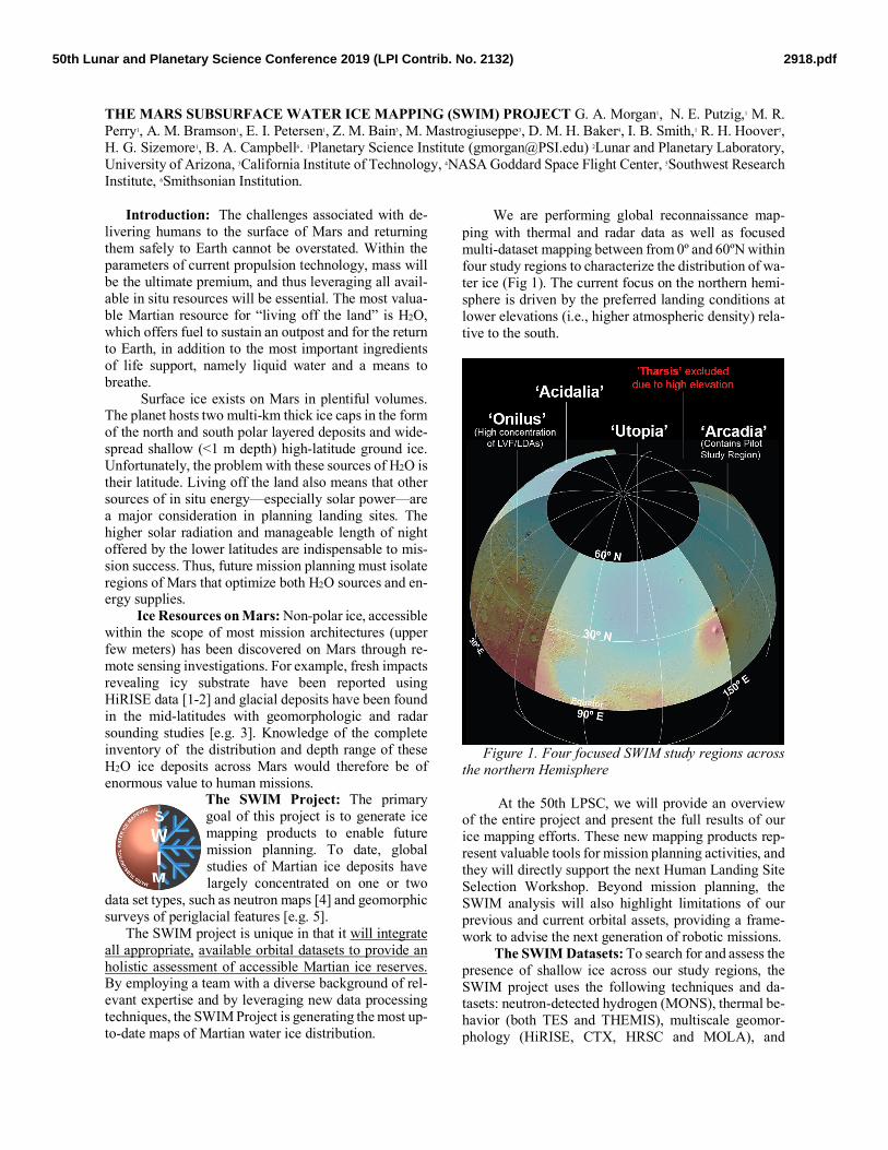
THE MARS SUBSURFACE WATER ICE MAPPING (SWIM) PROJECT G. A. Morgan 1 , N. E. Putzig, 1 M. R. Perry 1 , A. M. Bramson 1 , E. I. Petersen 1 , Z. M. Bain 3 , M. Mastrogiuseppe 3 , D. M. H. Baker 4 , I. B. Smith, 1 R. H. Hoover 5 , H. G. Sizemore 1 , B. A. Campbell 6 . 1 Planetary Science Institute ([email protected]) 2 Lunar and Planetary Laboratory, University of Arizona, 3 California Institute of Technology, 4 NASA Goddard Space Flight Center, 5 Southwest Research Institute, 6 Smithsonian Institution. Introduction: The challenges associated with de- livering humans to the surface of Mars and returning them safely to Earth cannot be overstated. Within the parameters of current propulsion technology, mass will be the ultimate premium, and thus leveraging all avail- able in situ resources will be essential. The most valua- ble Martian resource for “living off the land” is H2O, which offers fuel to sustain an outpost and for the return to Earth, in addition to the most important ingredients of life support, namely liquid water and a means to breathe. Surface ice exists on Mars in plentiful volumes. The planet hosts two multi-km thick ice caps in the form of the north and south polar layered deposits and wide- spread shallow (<1 m depth) high-latitude ground ice. Unfortunately, the problem with these sources of H2O is their latitude. Living off the land also means that other sources of in situ energy—especially solar power—are a major consideration in planning landing sites. The higher solar radiation and manageable length of night offered by the lower latitudes are indispensable to mis- sion success. Thus, future mission planning must isolate regions of Mars that optimize both H2O sources and en- ergy supplies. Ice Resources on Mars: Non-polar ice, accessible within the scope of most mission architectures (upper few meters) has been discovered on Mars through re- mote sensing investigations. For example, fresh impacts revealing icy substrate have been reported using HiRISE data [1-2] and glacial deposits have been found in the mid-latitudes with geomorphologic and radar sounding studies [e.g. 3]. Knowledge of the complete inventory of the distribution and depth range of these H2O ice deposits across Mars would therefore be of enormous value to human missions. The SWIM Project: The primary goal of this project is to generate ice mapping products to enable future mission planning. To date, global studies of Martian ice deposits have largely concentrated on one or two data set types, such as neutron maps [4] and geomorphic surveys of periglacial features [e.g. 5]. The SWIM project is unique in that it will integrate all appropriate, available orbital datasets to provide an holistic assessment of accessible Martian ice reserves. By employing a team with a diverse background of rel- evant expertise and by leveraging new data processing techniques, the SWIM Project is generating the most up- to-date maps of Martian water ice distribution. We are performing global reconnaissance map- ping with thermal and radar data as well as focused multi-dataset mapping between from 0º and 60ºN within four study regions to characterize the distribution of wa- ter ice (Fig 1). The current focus on the northern hemi- sphere is driven by the preferred landing conditions at lower elevations (i.e., higher atmospheric density) rela- tive to the south. Figure 1. Four focused SWIM study regions across the northern Hemisphere At the 50th LPSC, we will provide an overview of the entire project and present the full results of our ice mapping efforts. These new mapping products rep- resent valuable tools for mission planning activities, and they will directly support the next Human Landing Site Selection Workshop. Beyond mission planning, the SWIM analysis will also highlight limitations of our previous and current orbital assets, providing a frame- work to advise the next generation of robotic missions. The SWIM Datasets: To search for and assess the presence of shallow ice across our study regions, the SWIM project uses the following techniques and da- tasets: neutron-detected hydrogen (MONS), thermal be- havior (both TES and THEMIS), multiscale geomor- phology (HiRISE, CTX, HRSC and MOLA), and 2918.pdf 50th Lunar and Planetary Science Conference 2019 (LPI Contrib. No. 2132)
Transcript of THE MARS SUBSURFACE WATER ICE MAPPING (SWIM) …depths into the subsurface, we are subdividing them...
THE MARS SUBSURFACE WATER ICE MAPPING (SWIM) PROJECT G. A. Morgan1, N. E. Putzig,1 M. R. Perry1, A. M. Bramson1, E. I. Petersen1, Z. M. Bain3, M. Mastrogiuseppe3, D. M. H. Baker4, I. B. Smith,1 R. H. Hoover5, H. G. Sizemore1, B. A. Campbell6. 1Planetary Science Institute ([email protected]) 2Lunar and Planetary Laboratory, University of Arizona, 3California Institute of Technology, 4NASA Goddard Space Flight Center, 5Southwest Research Institute, 6Smithsonian Institution.
Introduction: The challenges associated with de-livering humans to the surface of Mars and returning them safely to Earth cannot be overstated. Within the parameters of current propulsion technology, mass will be the ultimate premium, and thus leveraging all avail-able in situ resources will be essential. The most valua-ble Martian resource for “living off the land” is H2O, which offers fuel to sustain an outpost and for the return to Earth, in addition to the most important ingredients of life support, namely liquid water and a means to breathe.
Surface ice exists on Mars in plentiful volumes. The planet hosts two multi-km thick ice caps in the form of the north and south polar layered deposits and wide-spread shallow (<1 m depth) high-latitude ground ice. Unfortunately, the problem with these sources of H2O is their latitude. Living off the land also means that other sources of in situ energy—especially solar power—are a major consideration in planning landing sites. The higher solar radiation and manageable length of night offered by the lower latitudes are indispensable to mis-sion success. Thus, future mission planning must isolate regions of Mars that optimize both H2O sources and en-ergy supplies.
Ice Resources on Mars: Non-polar ice, accessible within the scope of most mission architectures (upper few meters) has been discovered on Mars through re-mote sensing investigations. For example, fresh impacts revealing icy substrate have been reported using HiRISE data [1-2] and glacial deposits have been found in the mid-latitudes with geomorphologic and radar sounding studies [e.g. 3]. Knowledge of the complete inventory of the distribution and depth range of these H2O ice deposits across Mars would therefore be of enormous value to human missions.
The SWIM Project: The primary goal of this project is to generate ice mapping products to enable future mission planning. To date, global studies of Martian ice deposits have largely concentrated on one or two
data set types, such as neutron maps [4] and geomorphic surveys of periglacial features [e.g. 5].
The SWIM project is unique in that it will integrate all appropriate, available orbital datasets to provide an holistic assessment of accessible Martian ice reserves. By employing a team with a diverse background of rel-evant expertise and by leveraging new data processing techniques, the SWIM Project is generating the most up-to-date maps of Martian water ice distribution.
We are performing global reconnaissance map-ping with thermal and radar data as well as focused multi-dataset mapping between from 0º and 60ºN within four study regions to characterize the distribution of wa-ter ice (Fig 1). The current focus on the northern hemi-sphere is driven by the preferred landing conditions at lower elevations (i.e., higher atmospheric density) rela-tive to the south.
Figure 1. Four focused SWIM study regions across
the northern Hemisphere At the 50th LPSC, we will provide an overview
of the entire project and present the full results of our ice mapping efforts. These new mapping products rep-resent valuable tools for mission planning activities, and they will directly support the next Human Landing Site Selection Workshop. Beyond mission planning, the SWIM analysis will also highlight limitations of our previous and current orbital assets, providing a frame-work to advise the next generation of robotic missions.
The SWIM Datasets: To search for and assess the presence of shallow ice across our study regions, the SWIM project uses the following techniques and da-tasets: neutron-detected hydrogen (MONS), thermal be-havior (both TES and THEMIS), multiscale geomor-phology (HiRISE, CTX, HRSC and MOLA), and
2918.pdf50th Lunar and Planetary Science Conference 2019 (LPI Contrib. No. 2132)
SHARAD radar surface and subsurface echoes (Fig 2). To extract the maximum amount of information from the datasets, we are experimenting with multiple newly developed techniques, including: super-resolution SHARAD processing, which can improve the range res-olution by up to a factor of 3 [6], SHARAD surface re-flectivity [see Bain et al., this LPSC] and refined ther-mal modelling [see Hoover et al., this LPSC].
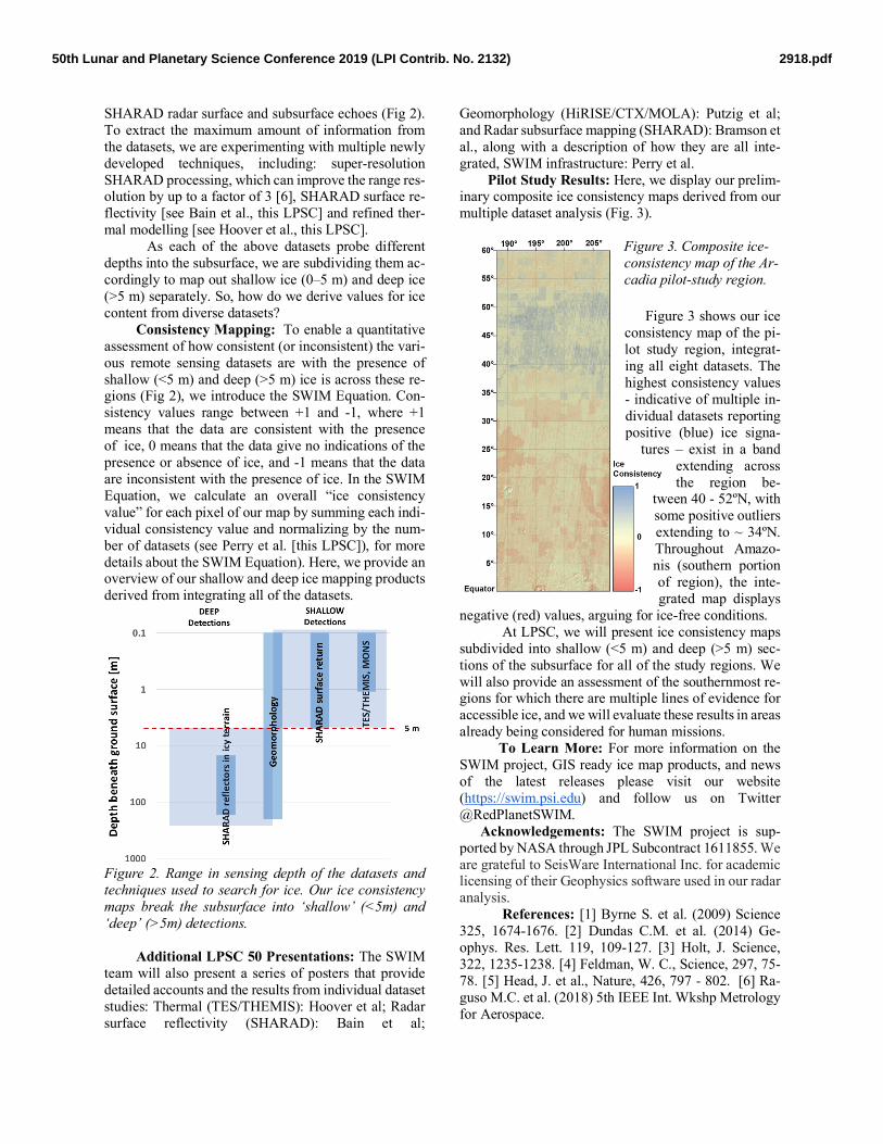
As each of the above datasets probe different depths into the subsurface, we are subdividing them ac-cordingly to map out shallow ice (0–5 m) and deep ice (>5 m) separately. So, how do we derive values for ice content from diverse datasets?
Consistency Mapping: To enable a quantitative assessment of how consistent (or inconsistent) the vari-ous remote sensing datasets are with the presence of shallow (<5 m) and deep (>5 m) ice is across these re-gions (Fig 2), we introduce the SWIM Equation. Con-sistency values range between +1 and -1, where +1 means that the data are consistent with the presence of ice, 0 means that the data give no indications of the presence or absence of ice, and -1 means that the data are inconsistent with the presence of ice. In the SWIM Equation, we calculate an overall “ice consistency value” for each pixel of our map by summing each indi-vidual consistency value and normalizing by the num-ber of datasets (see Perry et al. [this LPSC]), for more details about the SWIM Equation). Here, we provide an overview of our shallow and deep ice mapping products derived from integrating all of the datasets.
Figure 2. Range in sensing depth of the datasets and techniques used to search for ice. Our ice consistency maps break the subsurface into ‘shallow’ (<5m) and ‘deep’ (>5m) detections.
Additional LPSC 50 Presentations: The SWIM
team will also present a series of posters that provide detailed accounts and the results from individual dataset studies: Thermal (TES/THEMIS): Hoover et al; Radar surface reflectivity (SHARAD): Bain et al;
Geomorphology (HiRISE/CTX/MOLA): Putzig et al; and Radar subsurface mapping (SHARAD): Bramson et al., along with a description of how they are all inte-grated, SWIM infrastructure: Perry et al.
Pilot Study Results: Here, we display our prelim-inary composite ice consistency maps derived from our multiple dataset analysis (Fig. 3).
Figure 3. Composite ice-consistency map of the Ar-cadia pilot-study region.
Figure 3 shows our ice consistency map of the pi-lot study region, integrat-ing all eight datasets. The highest consistency values - indicative of multiple in-dividual datasets reporting positive (blue) ice signa-
tures – exist in a band extending across the region be-
tween 40 - 52ºN, with some positive outliers extending to ~ 34ºN. Throughout Amazo-nis (southern portion of region), the inte-grated map displays
negative (red) values, arguing for ice-free conditions. At LPSC, we will present ice consistency maps
subdivided into shallow (<5 m) and deep (>5 m) sec-tions of the subsurface for all of the study regions. We will also provide an assessment of the southernmost re-gions for which there are multiple lines of evidence for accessible ice, and we will evaluate these results in areas already being considered for human missions.
To Learn More: For more information on the SWIM project, GIS ready ice map products, and news of the latest releases please visit our website (https://swim.psi.edu) and follow us on Twitter @RedPlanetSWIM.
Acknowledgements: The SWIM project is sup-ported by NASA through JPL Subcontract 1611855. We are grateful to SeisWare International Inc. for academic licensing of their Geophysics software used in our radar analysis.
References: [1] Byrne S. et al. (2009) Science 325, 1674-1676. [2] Dundas C.M. et al. (2014) Ge-ophys. Res. Lett. 119, 109-127. [3] Holt, J. Science, 322, 1235-1238. [4] Feldman, W. C., Science, 297, 75-78. [5] Head, J. et al., Nature, 426, 797 - 802. [6] Ra-guso M.C. et al. (2018) 5th IEEE Int. Wkshp Metrology for Aerospace.
2918.pdf50th Lunar and Planetary Science Conference 2019 (LPI Contrib. No. 2132)