The Maine Geologist
18
Geological Society of Maine Newsletter, 2017, v. 43, no. 3, p. 1 The Maine Geologist NEWSLETTER OF THE GEOLOGICAL SOCIETY OF MAINE October 2017 Volume 43 Number 3 PRESIDENT’S MESSAGE What a great state for geology! Thinking back over the past few years of GSM and NEIGC field trips, I am impressed by the variety of interesting features you can reach in a few hours with a tank of gas. Sure, the calendar-worthy localities such as Katahdin, Mount Desert Island, and Portland Head spring to mind, but also places lesser known to the public such as Deboullie, Isle au Haut, and the town of Monroe. While non-geologists can appreciate the beauty of beaches, rivers, and mountaintop views, it takes the imagination of a Maine geologist to get excited by a gravel pit, salt marsh, sediment core, or sillimanite crystal. And new discoveries are still being made. Last year, Woody Thompson and Roger Hooke showed us a new kind of thin, braided meltwater deposit they call esker nets, discovered by lidar imagery. This summer, Lindsay Spigel walked us down into a large, prehistoric landslide deposit in Saco that was right under our noses but unrecognized until lidar. New techniques in geochronology, computer image analysis, ocean floor mapping, and drone technology are providing types of information that we have never had before. Our fall meeting on November 17 makes the link between accumulated knowledge and the evolving needs of technology. The connection is natural resources. As most geologists know, handheld devices, wind turbines, and electric car batteries require unprecedented amounts of elements such as nickel, zinc, and lithium. This year, Gary Freeman disovered a huge, multi-ton spodumene crystal (lithium silicate) in the western Maine pegmatite district. A mineral exploration company, Wolfden Resources, recently characterized the northern Maine mineral belt as "vastly under-explored" by modern standards. Will increasing demands for mineral resources, Maine's mineral potential, and new mining rules affect mineral exploration in the state? Please join us at the fall meeting for expert presentations and lively discussion. Henry Berry, GSM President [email protected] THE EDITOR’S MESSAGE The newsletter is distributed through e-mail in pdf format. Anyone with special needs please contact the Editor. Please send items of interest to: Amber Whittaker, Newsletter Editor [email protected] GSM WEBSITE: www.gsmmaine.org FACEBOOK: facebook.com/GSMMaine NEWS FROM THE STATE GEOLOGIST National Geologic Mapping Act Reauthorization Geologic maps have tremendous application to critical aspects of modern society. Given their capacity to identify mineral and fuel resources for creating and energizing modern conveniences, their use to characterize aquifers that provide 43% of the nation’s irrigation water and 37% of public supply water, and their application to landslide and earthquake risk assessment, it is difficult to overstate the contributions of geologic maps to society. In fact, a rigorous economic analysis of the benefit to cost ratio of geologic mapping indicates, conservatively, a 5:1 benefit. With such clear
Transcript of The Maine Geologist

Geological Society of Maine Newsletter, 2017, v. 43, no. 3, p. 1
The Maine Geologist NEWSLETTER OF THE GEOLOGICAL SOCIETY OF MAINE
October 2017 Volume 43 Number 3
PRESIDENT’S MESSAGE
What a great state for geology! Thinking back
over the past few years of GSM and NEIGC field
trips, I am impressed by the variety of interesting
features you can reach in a few hours with a tank of
gas. Sure, the calendar-worthy localities such as
Katahdin, Mount Desert Island, and Portland Head
spring to mind, but also places lesser known to the
public such as Deboullie, Isle au Haut, and the town
of Monroe. While non-geologists can appreciate
the beauty of beaches, rivers, and mountaintop
views, it takes the imagination of a Maine geologist
to get excited by a gravel pit, salt marsh, sediment
core, or sillimanite crystal.
And new discoveries are still being made. Last
year, Woody Thompson and Roger Hooke showed
us a new kind of thin, braided meltwater deposit
they call esker nets, discovered by lidar imagery.
This summer, Lindsay Spigel walked us down into
a large, prehistoric landslide deposit in Saco that
was right under our noses but unrecognized until
lidar. New techniques in geochronology, computer
image analysis, ocean floor mapping, and drone
technology are providing types of information that
we have never had before.
Our fall meeting on November 17 makes the
link between accumulated knowledge and the
evolving needs of technology. The connection is
natural resources. As most geologists know,
handheld devices, wind turbines, and electric car
batteries require unprecedented amounts of
elements such as nickel, zinc, and lithium. This
year, Gary Freeman disovered a huge, multi-ton
spodumene crystal (lithium silicate) in the western
Maine pegmatite district. A mineral exploration
company, Wolfden Resources, recently
characterized the northern Maine mineral belt as
"vastly under-explored" by modern standards. Will
increasing demands for mineral resources, Maine's
mineral potential, and new mining rules affect
mineral exploration in the state? Please join us at
the fall meeting for expert presentations and lively
discussion.
Henry Berry, GSM President
THE EDITOR’S MESSAGE
The newsletter is distributed through e-mail in
pdf format. Anyone with special needs please
contact the Editor. Please send items of interest to:
Amber Whittaker, Newsletter Editor
GSM WEBSITE: www.gsmmaine.org
FACEBOOK: facebook.com/GSMMaine
NEWS FROM THE STATE GEOLOGIST
National Geologic Mapping Act Reauthorization
Geologic maps have tremendous application to
critical aspects of modern society. Given their
capacity to identify mineral and fuel resources for
creating and energizing modern conveniences, their
use to characterize aquifers that provide 43% of the
nation’s irrigation water and 37% of public supply
water, and their application to landslide and
earthquake risk assessment, it is difficult to
overstate the contributions of geologic maps to
society. In fact, a rigorous economic analysis of the
benefit to cost ratio of geologic mapping indicates,
conservatively, a 5:1 benefit. With such clear

The Maine Geologist
Geological Society of Maine Newsletter, 2017, v. 43, no. 3, p. 2
benefits, why has the United States been among the
most poorly geologically mapped modern nations?
In the late 1980s and early 1990s, the directors
of the state geological surveys, acting through the
Association of American State Geologists (AASG),
recognized that a nation with only 20% coverage by
geologic maps was unacceptable and decided to do
something about it. Working together with (and
sometimes at odds with) our colleagues at the U.S.
Geological Survey, the State Geologists worked to
advance through the Congress the National
Geologic Mapping Act. Among the findings in the
Act was that, “A comprehensive, nationwide
program of geologic mapping based on Federal,
State, and private efforts is essential to
systematically build the Nation’s geologic-map data
base at a pace that responds to increasing demand
for data necessary for the long-term needs of the
Nation.” After two years of debate (short by current
standards!), the Act was first passed in 1992. It was
subsequently reauthorized in 1997, 1999, and 2009,
and is currently up for reauthorization.
In Maine, the State Geologic Mapping
Component (STATEMAP) of the Act has nearly
doubled the pace of geologic mapping. After a
surge in the late 1970s and early 1980s in advance
of the 1985 state geologic maps, geologic mapping
went into somewhat of a slump in the late 80s due
to budget cuts. Since 1993 through STATEMAP,
the Maine Geological Survey has completed about
150 geologic maps, mostly in southern and central
Maine but also in eastern and northern Maine. We
have received more than $1.9 million through the
program for mapping in critical areas, each federal
dollar matched by a state dollar. Our Geologic
Mapping Advisory Committee, with representation
from industry, consulting, academia, and
government agencies, has guided our geologic
mapping program to priority areas with great
success. Maps produced through STATEMAP have
been used by a broad range of users to address an
equally broad range of issues.
On September 14, Senators Angus King (I-
Maine) and Lisa Murkowski (R-Alaska) introduced
the National Geologic Mapping Act
Reauthorization Act to the Senate which would
reauthorize the programs through 2023. In a press
release about the bill, Senator King stated, “By
reauthorizing the National Cooperative Geologic
Mapping Program, we can help ensure responsible
environmental stewardship, mitigate natural
hazards, and foster economic growth.” I and the
membership of the AASG will be working in the
coming months to ensure the passage of this bill.
Robert G. Marvinney, State Geologist
2017 FALL MEETING
November 17, 2017
Augusta Civic Center
Following a lengthy bureaucratic process that
began in 2012, legislation has been enacted and a
new set of state metallic mining rules is expected to
take effect in November. This raises renewed
interest in Maine's mineral resources as well as
questions about the potential for development. Our

The Maine Geologist
Geological Society of Maine Newsletter, 2017, v. 43, no. 3, p. 3
Fall Meeting this year will feature a variety of
presentations from people who have been working
with Maine's mineral resources from various
perspectives. The program will include an
overview of what we know about Maine's bedrock
geology and mineral resources, and how to access
existing geologic information. We will hear from
geologists with experience working in metallic
mineral exploration, aggregate production, and
pegmatite mining. (See accompanying photo of a
huge spodumene crystal discovered this year in
western Maine pegmatite by Gary Freeman!) A
representative from the Maine DEP will walk us
through highlights of the new legislation and rules,
and what they might mean for exploration and
mining companies. Finally, we will look at the non-
geologic aspects of the issue, including a University
of Maine study of public perceptions of mining, and
the legislative process itself. A distinguished panel
including Maine legislators who participated in the
process will be on hand for questions and
discussion.
The meeting will be Friday, November 17 at
1:00 pm at the Augusta Civic Center in the
Washington and York Rooms on the second floor.
The final program will be posted on the
gsmmaine.org website before the meeting. For
questions, contact Bob Marvinney or Henry Berry.
2018 SPRING MEETING
ANNOUNCEMENT
April 6, 2018
Unity College
The spring GSM Meeting will take place at
Unity College’s Center for the Performing Arts on
Friday, April 6, 2018, in Unity. The conference
agenda, logistics, poster session details, and speaker
will be announced at a later date in the February
Newsletter.
Kevin Spigel
2018 SUMMER FIELD TRIP
ANNOUNCEMENT
July 28-29, 2018
North Maine Woods
Bedrock investigations in the North Maine
Woods have been absent for several decades. Brad
Hall’s bedrock geologic mapping in the southern
end of the Munsungun Anticlinorium and Gary
Boone’s bedrock geologic mapping in the Deboullie
Lake and Fish River Lake areas in the 1950s and
‘60s provided the most authoritative maps and are
still the primary source of our knowledge. With the
exception of intensive mineral exploration activities
(soil and stream sediment geochemical survey and
borehole drilling) in the middle Munsungun
Anticlinorium region, in particular in the area
around Bald Mountain polymetallic deposit, around
1980, there has not been any bedrock mapping since
Hall’s and Boone’s work, except the bedrock
mapping in a small area around the Bald Mountain
deposit by USGS geologists in the middle 1990s.
A fortuitous archaeological discovery of a
probable paleoindian lithic reduction workshop at
Round Mountain in 2014 caused renewed interest in
the bedrock. Round Mountain was recognized as an
area of potential archaeological significance by the
late Robson Bonnichsen in the early 1980s. In the
past, limited reconnaissance was conducted by
several archaeologists but no detailed work at
Round Mountain was performed. The Munsungun
Lake area (including Munsungun Ridge, Norway
Bluff and Willard Ridge) is the best-known source
of the cherty materials for stone tool artifacts in
northern Maine, which have been found at sites
throughout northeastern North America. During the
survey of the newly-discovered Round Mountain
archaeological site, it became obvious that the
archaeologists needed to know where the artifacts
were sourced and if multiple sources existed. A
collaborative effort was made between MGS and
the Maine Historic Preservation Commission
(MHPC) to re-map the bedrock in the Mooseleuk
Lake and Round Mountain quadrangles. Supported
by MGS, USGS, and MHPC, geo-archaeologists
and geologists Dave Putnam, Steve Pollock and
Chunzeng Wang, under supervision of State

The Maine Geologist
Geological Society of Maine Newsletter, 2017, v. 43, no. 3, p. 4
Geologist Dr. Robert Marvinney and State Senior
Archaeologist Dr. Arthur Spiess, began to survey
archaeological sites and map bedrock in the middle
Munsungun Anticlinorium region in 2015. As
exciting geological discoveries have been made the
North Maine Woods geology has become a hot
topic again.
The GSM 2018 summer field trip will highlight
the new discoveries in the middle Munsungun
Anticlinorium region. To name a few, in geo-
archaeology: (1) the Munsungun Lake area is not
the single source of the cherty rocks utilized for
prehistoric stone tool manufacture and (2) the lithic
material used for stone tools is not strictly chert, but
also felsic fine tuff, at least in the Round-Middle-
Peaked Mountain ridge area. With regards to the
bedrock geology, here is a short list: (1) the
completely-redrawn bedrock map in the region; (2)
several newly identified and proposed formations,
including the Rowe Lake and Horseshoe Pond
Formations; (3) an improved understanding of the
Ordovician volcanic rocks and their spatial relation
to other units as well as their absolute ages obtained
from radiometric dating; (4) discovery of the basal
conglomerate member of the Seboomook Formation
as well as excellent outcrops of the Taconic and
Penobscottian unconformities; (5) intrusive-
magmatic-hydrothermal Cu-Au mineralization at
Chandler Mountain; and (6) rare and excellent
exposure of geological features and unique rocks,
including gem-quality-jasper-block volcanic
breccia, pillow basalts, and volcanic tuff.
The trip will be run on the last weekend of July
when mosquitoes and black flies disappear (July 28-
29; but trip attendants should arrive on July 27
afternoon-evening). Lodging will be at a lake-front
camp which is located on a very quiet lake in the
woods with facilities (e.g. log cabin, kitchen,
outhouse, canoes, boats, kayaks, fishing poles, and a
huge swimming pool – the lake); you will bring
tents and sleeping bags; lodging is FREE. More
logistics will be detailed in the 2018 Spring GSM
Newsletter. Mark your calendar and think of it as
your summer 2018 vacation trip in our beautiful and
wild North Maine Woods.
Chunzeng Wang
David Putnam
Steve Pollock
2017 SUMMER FIELD TRIP RECAP
In Arthur's Footsteps
The skeptics have been soundly repudiated!
Admittedly, a foray into the congested Route 1
corridor of southern Maine during the height of
tourist season was a bold and risky plan for such a
large group. But our stalwart band of geologists did
better than merely survive the 2017 summer field
trip, we had a wonderful time. We followed parts of
Arthur Hussey's 2015 guidebook from Cape
Neddick to Spring Point, feasting on a geologic
smorgasbord of structural geology, bedrock
stratigraphy, igneous petrology, coastal marine
environments, sea level rise, beach-dune systems,
coastal resiliency, and landslides in the Presumpscot
Formation. The 37 participants were shuttled by
vans provided by GSM members, which made it
possible. A dense fog Saturday morning persuaded
the tourists to have a late breakfast and visit the
shops, which allowed us unexpectedly clear access
to the geology of the Marginal Way footpath in
Ogunquit. We successfully visited all the stops on
our itinerary, including an optional after-dinner stop
Saturday on the Biddeford Pool shore as the sun
was setting beneath a red sky. Stop highlights and
handouts from the field trip are posted on the GSM
web site. A scrapbook of photos by Sarah Hall (and
one by Chunzeng Wang) is included at the end of
the newsletter.
Henry Berry, GSM President

The Maine Geologist
Geological Society of Maine Newsletter, 2017, v. 43, no. 3, p. 5
2017 NEIGC
A great success!
This Fall (September 29 – October 1, 2017)
Bates Geology and the Maine Mineral and Gem
Museum hosted the NEIGC Conference. A great
turnout of professionals and students traipsed
around western Maine and northern New
Hampshire looking at a number of diverse geologic
settings. With 320 registered, including 177
students (!), this was one of the larger NEIGC
meetings in some time. The Maine Mineral and
Gem Museum put on a first-rate Friday night
reception with well over 200 in attendance, and the
Gould Academy dining services equaled that with
the Saturday banquet at beautiful Ordway Hall.
Thanks to all the trip leaders, especially the Maine
contingent, for making the meeting a success.
Dyk Eusden
2018 GRAND CANYON RAFTING TRIP
August 6-13, 2018
Again as in the past 10 years, Alison Jones and
Fred Beck will be leading an 8-day rafting trip of
about 188 miles through the Grand Canyon. Many
GSM members have made this trip in the past, some
going twice. The trip begins at Lee’s Ferry,
Arizona, and ends at Whitmore Wash followed by a
short helicopter ride to an airstrip at the Bar 10
Ranch on the North Rim. The dates are August 6-
13, 2018. From there you will be flown to Las
Vegas or Lee’s Ferry.
The emphasis of these trips is of course about
the geology, from Precambrian through the Permian
as well as an abundance of more recent events
including volcanism, breccia pipe formation, spring
deposited travertine, debris flows and much more.
At least two modest hiking trips are made each day
into slot canyons or other side canyons and
tributaries to visit waterfalls, fossils, archaeological
sites and just to get out and stretch our limbs or
swim in clear warm water. Some choose not to do
some of the side trips and just relax or read near the
rafts while others go adventuring.
There are usually as many non-geologists on
these trips as geologists and they get as much out of
the trip as the geologists; a perfect geologic
classroom. We have often had teenagers on these
trips and that has added to the fun.
The outfitter we use is Hatch River Expeditions,
one of the most experienced companies licensed to
operate in the Grand Canyon. There will be two 34-
foot inflatable boats powered by 30 HP outboards.
No paddling or rowing on this trip. Each raft
accommodates 16 people as well as all our gear,
food, etc. All meals are prepared by the Hatch
guides and Hatch also provides all tents, cots,
bedding, etc.
If you are interested in more details, contact
Fred Beck at [email protected] or Alison Jones
at [email protected]. We anticipate
that we will have a full complement of travelers so
an early commitment is advised.
NEWS FROM THE CAMPUSES
Bates College
Our department is in full teaching mode now.
Some of the things we are working on, besides our
courses and student research projects, are: 1)
making our STEM classes, and Bates in general,
more welcoming and inclusive to under-represented
students; 2) working with the Boston-based firm

The Maine Geologist
Geological Society of Maine Newsletter, 2017, v. 43, no. 3, p. 6
Payette on some long term and very overdue
renovations to our Carnegie Science building; and
3) evaluating via a formal departmental review
where we want to be in 5, 10, etc. years as the field
of geology changes.
Dyk Eusden, Chair
Bowdoin College
On November 29, 2017, Bowdoin will host Dr.
Heather Savage as a Distinguished Lecturer through
GeoPRISMS – an NSF sponsored organization
(http://geoprisms.org/). She will deliver a public
lecture entitled “The Science and Pseudoscience of
Earthquake Prediction” at 7pm in the Beam
Classroom of the Visual Arts Center at Bowdoin
(adjacent to the Art Museum). Parking and
attendance are free. Please join us!
Rachel Beane has been elected as a Fellow of
the Geological Society of America and will be
recognized at the annual meeting in October. As her
nominator Reinhard Wobus states, “Rachel is one of
the most effective and progressive national leaders
in Geoscience Education, notably as co-PI of "On
the Cutting Edge" and convener of many of its
workshops and webinars. She and her
undergraduate students have also made significant
contributions to the study of silicic magma
systems.”
https://www.geosociety.org/GSA/About/awards/GS
A_Fellows/GSA/Awards/Fellows.aspx
Collin Roesler was recently awarded a grant to
investigate the role of diatoms as mediators of
carbon flux to the twilight zone in the Northeast
Pacific and Atlantic Oceans. This $1.1 million grant
will support her research for the next three years
and support summer research fellowships for
Bowdoin undergraduates. It will also bring
infrastructure for observing phytoplankton
community structure in real time. More information
about this exciting project can be found here:
http://oceanexports.org/
Phil Camill recently published a paper in the
Journal of Geophysical Research-Biogeosciences
on his work on determining how much carbon is
contained in peat bogs. This is part of a series of
papers focused on work that Camill has conducted
in the Canadian low Arctic with colleagues from St.
Olaf College, Trinity College, the Science Museum
of Minnesota, and several Bowdoin undergraduates.
A short article about this project can be found here:
http://community.bowdoin.edu/news/2017/09/peat-
bogs-that-may-contain-important-climate-change-
indicators/
Members of the EOS department led a trip for
20 students to Iceland in June 2017. Highlights of
the trip were posted to Instagram (follow us
@bowdoineos). An article and series of videos
about the trip can be found here:
http://community.bowdoin.edu/news/2017/09/solvin
g-an-earth-sized-puzzle-bowdoin-goes-to-iceland/
Emily Peterman spent part of the summer in
Greece with two Bowdoin students conducting
research on ultrahigh-pressure rocks in the Rhodope
Mountains in collaboration with Michael Williams
(UMass-Amherst). This research is supported by a
recent grant awarded to Peterman and Williams
from the National Science Foundation.
Peter Lea has been working with Satya Kent ’19
to investigate the Scarborough Marsh and its
response to rising sea levels. They have set up a
research station in the Scarborough Marsh to
monitor and characterize sediment flux.
http://community.bowdoin.edu/news/2017/08/a-

The Maine Geologist
Geological Society of Maine Newsletter, 2017, v. 43, no. 3, p. 7
bowdoin-investigation-can-a-maine-marsh-survive-
rising-seas/
Recent graduates, Megan Frenkel ‘16 and
Gabriela Serrato Marks '15 are each lead authors
on papers recently published in Deep Sea Research
I and Paleoceanography with their advisor Michèle
LaVigne. The work included in these papers was
supported by an NSF grant to LaVigne and included
collaborations with UC Davis and Woods Hole
Oceanographic Institution. A short article about this
contribution can be found here:
http://community.bowdoin.edu/news/2017/06/recent
-grads-paper-on-deep-sea-coral-published-in-
academic-journal/
Emily Peterman
Unity College
Students are busy traveling around central
Maine studying glacial landforms, river systems,
soils and a number of rock outcrops in the fall
courses at Unity College. The Geomorphology class
has been extra busy traveling up north on an
overnight camping trip to visit the Debsconeag Ice
Caves and discuss the theories surrounding
glaciation on Mt. Katahdin on their hike to
Chimney Pond. More recently, the students traveled
to Bethel to participate in the 109th NEIGC
Meeting to learn more about a variety of other
geology-themed topics from professionals in the
field. Many more field trips are ahead! Thanks to an
internal grant received by Dr. Kevin Spigel, the
students in Geomorphology are in the midst of a
class research project studying oxbows along Sandy
Stream. We have been busy coring and conducting
topographic surveys of these relict channels with
the intention of reconstructing bankfull channel
dimensions and discharge and comparing the results
to modern-day conditions. Slowly the radiocarbon
dates are coming back in! Look for this work to be
presented at the Spring GSM Meeting.
Kevin Spigel

The Maine Geologist
Geological Society of Maine Newsletter, 2017, v. 43, no. 3, p. 8
University of Maine at Presque Isle
Kevin McCartney has returned from nearly nine
months in Szczecin Poland as the first Fulbright
Scholar from northern Maine. He spent his time in
Poland working on a range of silicoflagellate
studies from Cretaceous to Recent. His two
primary projects while in Poland were a study of
Paleocene to Eocene silicoflagellate biostratigraphy
in southern latitudes, and the first of several
pending studies on silicoflagellate evolution in the
Cenozoic. Associated with his Polish work were
invited talks at the 14th International Diatom
Symposium and 11th International Phycological
Congress.
Kevin will be returning to Poland for the
weekend of February 17th 2018 to help launch the
inaugural "Planet Head Day" event in Poland. This
is an extension of a science-education and cancer-
awareness event he has helped run for 11 years in
northern Maine. The Maine event will this year be
on March 10th, but in subsequent years there are
plans for an International Planet Head Day.
Kevin McCartney
TREASURER’S REPORT
Fiscal Year August 1, 2016 to July 31, 2017 Actual
Income
Dues Paid $3,995.00
Donations for Anderson Fund $255.00
Subtotal $4,250.00
Expenses
Postal Stamps $9.40
Annual Corporate Report $35.00
Dues Reminder Mailing to all
Members
$170.69
Meeting Expenses
Fall Meeting 2016 $1,468.45
Spring Meeting 2017 – Student
Awards
$250.00
Anderson Fund Awards
UMF Geology Club Field Trip $750.00
Web site expenses $72.20
Subtotal $2,505.74
Net Increase $1,744.26
End of Year Asset Summary July 31, 2017 Account Sub-Account July 31, 2017
General Fund
Business Savings $1,067.68
Checking $2,394.51
Total 3,462.19
Anderson
Fund
Business Savings $260.00
4 Certificates of
Deposit
$21,100.00
Total $21,360.00
Total Assets All Funds $24,822.19
Liabilities1 $0.00 1As-yet-uncleared checks
Respectfully submitted,
Bruce E. Hunter, Treasurer 2017
Duties shared with Steve Kelley

The Maine Geologist
Geological Society of Maine Newsletter, 2017, v. 43, no. 3, p. 9
UPCOMING EVENTS
Date Event Location Organizer
November 5-7 2017 Exploration, Mining and
Petroleum Conference
Fredericton, New
Brunswick, Canada
New Brunswick Department
of Energy and Resource
Development
November 17 2017 GSM Fall Meeting Augusta Civic Center GSM Executive Council
March 18-20
2018 Geological Society of
America Northeastern Section
52nd Annual Meeting
Burlington, Vermont University of Vermont
April 6 2018 GSM Spring Meeting Unity College Kevin Spigel
July 28-29 2018 GSM Summer Field Trip Northern Maine,
west of Ashland Chunzeng Wang
August 6-13 2018 Grand Canyon Rafting Trip Lee’s Ferry, Arizona Fred Beck and Alison Jones
2017 GSM SUMMER FIELD TRIP IMAGES
1. Early morning group photo around Bench 2 on the Marginal Way, Ogunquit. The plaque inscription reads: "In
honor of Bowdoin College Professor Arthur M. Hussey II, Ph.D. Marginal Way geologist."

The Maine Geologist
Geological Society of Maine Newsletter, 2017, v. 43, no. 3, p. 10
2. Leader Wally Bothner handing out maps at Stop 1.
3. Inverted graded beds in the Kittery Formation. Ian's finger is parallel to the second cleavage, pointing in the
direction of younging. Devil's Kitchen, Marginal Way.

The Maine Geologist
Geological Society of Maine Newsletter, 2017, v. 43, no. 3, p. 11
4. Densely packed summer "cottages" perched atop the Cape Neddick gabbro at Stop 2B.
5. Bluish-gray cordierite produced by high-temperature contact metamorphism, Cape Neddick.

The Maine Geologist
Geological Society of Maine Newsletter, 2017, v. 43, no. 3, p. 12
6. Minor faults offset thin bedding in the Kittery Formation, Cape Neddick.
7. Dunne's ice cream - a plentiful and scrumptious treat!

The Maine Geologist
Geological Society of Maine Newsletter, 2017, v. 43, no. 3, p. 13
8. Leader Dan Belknap points out a raised shoreline feature. Laudholm Farm, Stop 3.
9. The new award-winning bedrock map of the Kittery 1:100,000-scale quadrangle, displayed against the Biddeford
granite. Home Depot, Biddeford, Stop 4.

The Maine Geologist
Geological Society of Maine Newsletter, 2017, v. 43, no. 3, p. 14
10. The new GSM logo points the way to the cookout at UNE. Thanks, Denise!
11. Stop leaders Steve Dickson and Pete Slovinsky discuss the Saco Bay beach system on a gorgeous day. Ferry
Beach State Park, Stop 5.

The Maine Geologist
Geological Society of Maine Newsletter, 2017, v. 43, no. 3, p. 15
12. Geotube, rip-rap, and infrastructure at risk at Camp Ellis, Stop 5.
13. Stop leader Lindsay Spigel gives an overview of historic and pre-historic Maine landslides before walking us
through a large landslide deposit at Stop 6.
The Maine Geologist
Geological Society of Maine Newsletter, 2017, v. 43, no. 3, p. 16
14. Lindsay demonstrates the landslide geomorphology while standing at the base of the scarp.
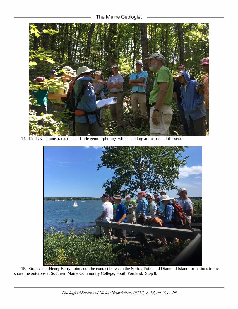
15. Stop leader Henry Berry points out the contact between the Spring Point and Diamond Island formations in the
shoreline outcrops at Southern Maine Community College, South Portland. Stop 8.

The Maine Geologist
Geological Society of Maine Newsletter, 2017, v. 43, no. 3, p. 17
16. The shore of Casco Bay is a perfect setting for reading A Philosophical Preamble from Arthur Hussey's book, A
Guide to the Geology of Southwestern Maine. Sublime! Thank you, Arthur. (C. Wang photo)

Geological Society of Maine Newsletter, 2017, v. 43, no. 3, p. 18
MEMBERSHIP DUES STATEMENT
The GEOLOGICAL SOCIETY OF MAINE, INC. (often referred to as GSM) is a non-profit corporation established as an educational Society to advance the professional improvement of its members; to inform its members and others of current and planned geological programs in Maine; to encourage continuing social contact and dialog among geologists working in Maine; and to further public awareness and understanding of the geology of the State of Maine; and of the modern geological processes which affect the Maine landscape and the human environment.
The Society holds three meetings each year, in the late fall (Annual Meeting), early spring, and mid-summer (usually a field trip). A newsletter, The Maine Geologist, is published for all members three times a year. The Society year runs from Aug. 1 to Jul. 31. Annual dues and gift or fund contributions to the Society are tax deductible. There are four classes of membership:
2017 FEE SCHEDULE
$ 20.00 REGULAR MEMBER Graduate geologists, or equivalent, with one year of practice in geology, or with an advanced degree. $ 20.00 INSTITUTIONAL MEMBER Libraries, societies, agencies, businesses with interests in or practicing geology and related disciplines. $ 10.00 ASSOCIATE MEMBER Any person or organization desirous of association with the Society. $ 5.00 STUDENT MEMBER Persons currently enrolled as college or university students. THE GEOLOGICAL SOCIETY OF MAINE ANNUAL RENEWAL / APPLICATION FOR MEMBERSHIP
Regular Member $ 20.00 $__________ Name ____________________________________ Make checks payable to: Institutional Members $ 20.00 $__________ Geological Society of Maine Associate Member $ 10.00 $__________ Address ____________________________________ Steve Kelley, GSM Treasurer Student Member $ 5.00 $__________ 102 Staples Rd Contributions to GSM $__________ ____________________________________ Limington, ME 04049 (please write gift or fund on check) TOTAL ENCLOSED $__________ ____________________________________ Email Address ____________________________________
(GSM funds include the Walter Anderson Fund _______ , and discretionary gifts as noted by contributor)
THE MAINE GEOLOGIST is the Newsletter of the Geological Society of Maine, published three times a year, in mid-winter, summer, and early fall, for members and associates. Items for inclusion in the Newsletter may be directed to:
2017/2018 SOCIETY YEAR BEGAN August 1
PLEASE SEND DUES TO TREASURER.
THE GEOLOGICAL SOCIETY OF MAINE c/o Amber Whittaker, Newsletter Editor Maine Geological Survey 93 State House Station Augusta, ME 04333-0093 [email protected]
THE GEOLOGICAL SOCIETY OF MAINE c/o Steve Kelley, GSM Treasurer 102 Staples Rd Limington, ME 04049
PLEASE PAY YOUR DUES!
THE GEOLOGICAL SOCIETY OF MAINE EXECUTIVE COUNCIL
President Henry Berry (2018) Maine Geological Survey, [email protected] Vice President Sarah Hall (2018) College of the Atlantic, [email protected] Secretary Lisa Jacob (2018) Sevee & Maher Engineers Inc., [email protected] Treasurer Steve Kelley (2017) Haley & Aldrich, [email protected] Newsletter Editor Amber Whittaker (2018) University of Maine, [email protected] Directors Keith Taylor (2017) St. Germain Collins, [email protected] Steve Kelley (2018) Haley & Aldrich, [email protected] Martin Yates (2019) University of Maine, [email protected]