The ‘Karawari Caves Precinct’ - - ResearchOnline@JCU et al 2014.pdf · The ‘Karawari Caves...
57
The ‘Karawari Caves Precinct’ of the Sepik River Basin, Papua New Guinea Report prepared by Jennifer Gabriel and Paul Gorecki December, 2014
Transcript of The ‘Karawari Caves Precinct’ - - ResearchOnline@JCU et al 2014.pdf · The ‘Karawari Caves...

The ‘Karawari Caves Precinct’
of the Sepik River Basin,
Papua New Guinea
Report prepared by Jennifer Gabriel and Paul Gorecki
December, 2014

Published by The Cairns Institute, James Cook University,
Cairns
ISBN 978-0-9941500-7-3
This report is licenced under a Creative Commons Attribution
3.0 Australia licence. You are free to copy, communicate and
adapt this work, so long as you attribute James Cook
University [The Cairns Institute] and the authors.
This report should be cited as: Gabriel, J. & Gorecki, P. (2014).
The ‘Karawari Caves Precinct’ of the Sepik River Basin, Papua
New Guinea. Cairns: James Cook University.
The views and opinions expressed in this publication are those
of the authors and do not necessarily reflect those of the
Cairns Institute or James Cook University.
This report is available for download from
http://researchonline.jcu.edu.au/37196/
December 2014

Contents Figures ......................................................................................................................................... i
About the Authors .................................................................................................................... iii
The ‘Karawari Caves Precinct’ of The Sepik River Basin, Papua New Guinea ........................... 1
The Sepik Basin: A Bio-Cultural Landscape ............................................................................ 3
The Karawari (alt. Korewori) and Arafundi Region ................................................................ 4
A Storied Landscape ............................................................................................................... 6
Trading Networks and Intercultural Exchange ....................................................................... 8
Significance of the ‘Karawari Cave Precinct’ ........................................................................ 11
The Spiritual Landscape ....................................................................................................... 27
Paul Gorecki’s notes on Bambiang Hamlet .............................................................................. 31
Carved Spirit Figures ............................................................................................................ 37
Ongoing Research, Activism and Management ................................................................... 43
Saving the Caves: notes from the field, by Nancy Sullivan .................................................. 45
Chronology of Research ....................................................................................................... 47
Reference Material .................................................................................................................. 48
Special Acknowledgements ..................................................................................................... 50

i
Figures Figure 1: Life along the Arafundi................................................................................................ 2
Figure 2: Upper Karawari and Arafundi Region, Sepik River, PNG ............................................ 2
Figure 3: The Nombokopi Rock shelter with its present owners and guardians ....................... 4
Figure 4: Arafundi girl travelling alone ...................................................................................... 6
Figure 5: Woman with baby in bilum at Wagam Crossing ......................................................... 6
Figure 6: Kina shell stencil in cave ............................................................................................. 8
Figure 7: Kina shell at Auwim ..................................................................................................... 9
Figure 8: Shell and nose ornaments .......................................................................................... 9
Figure 9: Armbands .................................................................................................................. 10
Figure 10: Cassowary bone dagger .......................................................................................... 10
Figure 11: Stencil of bone dagger, Pundimbung Shelter ......................................................... 11
Figure 12: Paul Gorecki conducting research at Pundimbung Cave ........................................ 13
Figure 13: Panels of cave art in Pundimbung Cave .................................................................. 14
Figure 14: Auwim Cliff which can also be seen from Yimas .................................................... 14
Figure 15: Stencils over panel collapse, Pundimbung Shelter ................................................. 15
Figure 16: Stencils and trophies, Pundimbung Shelter ............................................................ 16
Figure 17: Radiating stars shapes and concentric circles ........................................................ 16
Figure 18: Various stencil pigments, Timblari shelter ............................................................. 17
Figure 19: Living floor at Timblari shelter ................................................................................ 18
Figure 20: Timblari rock shelter ............................................................................................... 20
Figure 21: Paigun shelter – hand stencil on tree ..................................................................... 20
Figure 22: Stencils and geometric paintings, Kalapul Shelter .................................................. 22
Figure 23: Pundimbung Cave ................................................................................................... 23
Figure 24: Pundimbung sacred chamber ................................................................................. 24
Figure 25: Two men playing flutes in Pundimbung Caves ....................................................... 25
Figure 26: Edible leaf stencil – Pundimbung Cave ................................................................... 26
Figure 27: Haus Tambaran at Auwim ...................................................................................... 27
Figure 28: Sago bark painting at Auwim Haus Tambaran ....................................................... 28
Figure 29: Archaeological party in 1987 resting at Kambrimeri Gorge with Wagam Cave
behind the trees just above Rhys Jones (standing) ................................................................. 29
Figure 30: Example of sago bark painting ................................................................................ 32
Figure 31: Example of sago bark painting ................................................................................ 33
Figure 32: Example of sago bark painting ................................................................................ 34
Figure 33: Example of sago bark painting ................................................................................ 35
Figure 34: Example of sago bark painting ................................................................................ 36
Figure 35: Bambiang Haus Tambaran...................................................................................... 37
Figure 36: Carving of Tamarat spirit ........................................................................................ 38
Figure 37: Carving of Enu spirit ................................................................................................ 38
Figure 38: Carving of Bowi spirit .............................................................................................. 38
Figure 39: Carving of Mareri spirit ........................................................................................... 38
Figure 40: Sacred carving in Pundimbung Cave (Auwim Territory) ......................................... 39

ii
Figure 41: Ceremonial bowl at Christies Auction .................................................................... 42
Figure 42: Karawari charm ....................................................................................................... 42
Figure 43: Contemporary research .......................................................................................... 44
Figure 44: Meakambut at Imboim hamlet ............................................................................... 44
Figure 45: Documenting the caves of the Upper Karawari ..................................................... 45
Figure 46: Namata meeting ..................................................................................................... 46

iii
About the Authors
Jennifer Gabriel is a PhD scholar and tutor in anthropology in the College of Arts, Society
and Education at James Cook University in Cairns.
Jennifer was born in Papua New Guinea. Her academic research interests include natural
resource governance, Southeast Asian capitalism, World Heritage governance and
community consultation in the tropics, research, and course development.
She is a Research Fellow of The Cairns Institute at James Cook University and is a member of
the Australian Anthropological Association of Australia (AAS), Association of Social
Anthropologists in Oceania (ASAO) and the Asian Studies Association of Australia (ASAO).
She is currently working on an interdisciplinary collaborative project involving World
Heritage Nomination and community consultation in Papua New Guinea.
Paul Gorecki is an anthropologist and archaeologist who received his Master degree in 1975
from the Sorbonne (Paris) and his PhD in 1983 from the University of Sydney. Between 1980
and 1995 he held academic positions at the University of Sydney, the Australian National
University (ANU) and James Cook University. Since 1995 he has been a full time consultant
in Native Title claims and in Cultural heritage management in Queensland. During his entire
academic life, Paul Gorecki carried out archaeological research in Melanesia, principally in
remote areas of Papua New Guinea (Wahgi Valley, Jimi Valley, Yuat Valley, New Ireland,
Sepik River, Wewak Coast, Arafundi River, and Vanimo Coast). The report presented here is
from results of a 1987 research carried out in the upper Arafundi River with the late Rhys
Jones while they were both at the Research School of Pacific Studies, ANU. This report is
dedicated to the memory of Rhys Jones.

1
The ‘Karawari Caves Precinct’ of The Sepik River Basin, Papua New
Guinea
Midway up the slopes of the Andogoro, Moirutapa, and Kundiman mountains that rise up
from the surrounding floodplains and separate East Sepik Province from Enga and Western
Highlands Provinces in Papua New Guinea, are the traditional settlements of the Upland
Arafundi people (Roscoe & Telban 2004:94). Galleries of stencils adorn the walls of caves
once used as spirit houses and shelters by the Upland Arafundi people. In the limestone
caves they buried their dead, initiated young men, and sheltered from their enemies.
Common among the galleries of stencils are hands made by blowing, spraying or spitting a
mouthful of ochre over an outstretched hand. The hand stencils are enduring personal
signatures on the cave walls. These hands and other stencils (e.g. kina shells, cassowary feet
and other prints) are yet to be dated but the extensive nature of the painted galleries that
adorn the walls of these rock shelters, as well as other living traditions (haus tambarans,
carved wood and stone figurines, bark paintings etc.) provide real insight into the culture
and symbolic conventions of the semi-nomadic peoples who inhabited the caves.
Many of the caves were once multipurpose ceremonial, burial and hiding grounds. The
caves were also used to increase success in warfare and hunting. These are places said to be
first occupied by the ancestors. The caves are part of a spiritual landscape defined by rituals,
stories, objects, and practices that are intimately linked to knowledge about life and
ancestors. As Bruno David and Meredith Wilson (2002) emphasise, landscapes are not
merely “out there” but are constructed in social engagement. The inscriptions of people’s
presence often remains as personal expressions of place marking, but these places and
landscapes are socially and sensually anchored through the production of a sense of
belonging. Paul Gorecki, who has had extensive experience of archaeological work in Papua
New Guinea, believes the caves of the Karawari and Upper Arafundi could constitute “the
greatest example of rock art in the whole of Melanesia” (Gorecki & Jones 1987a; 1987b:3).
In 1987, Gorecki and Jones recommended that the caves received national protection
before their location was publically revealed, in order to preserve the significance of the site
for the people.
The caves and the associated cultural assemblage of practices, beliefs and knowledge are
the expression of how the people of this area understand their relationships to places,
landscapes and geography. These material and metaphysical expressions are the property of
small groups of people living along the Arafundi River hills (Figure 1), whom are unique
among tropical forest people firstly, because they lived almost entirely as hunter gatherers
at contact, and secondly because they were the creators of a rock art tradition that made
caves functionally equivalent to men’s spirit houses (Roscoe & Telban 2004:94). The cluster
of caves in at least three river tributaries, which include villages and hamlets in the upper
Karawari-Arafundi region can be defined inclusively as the ‘Karawari Caves Precinct’ (Figure
2).

2
Figure 1: Life along the Arafundi
Photo: Paul Gorecki (1987)
Figure 2: Upper Karawari and Arafundi Region, Sepik River, PNG
Map Courtesy of Edmundo Edwards: Cruz Mayor Expedition (2008)
http://www.expedicioncruzmayor.com/kariwari-region-en.html?lang=en-GB

3
The Sepik Basin: A Bio-Cultural Landscape
The Sepik River is a place where peoples’ livelihoods, identities, stories and belief systems
have established an ‘intrinsic cultural landscape’ (e.g. Swadling et. al. 1988). The Sepik River
Basin is one of the linguistically most complex areas in Papua New Guinea. This diversity
may be partly explained by difficult terrains (extensive swamps and rugged mountains), and
the small size of communities. Geomorphic events have shaped the Sepik landscape at
various stages, but the cultural distinctions between and within groups along the river can
only be partially attributed to environmental differences (Schuster 1990:69). Intercultural
connections within the Sepik Basin can be attributed to the ways in which Sepik people
borrowed/sold or leased elements of their ritual corpus to others. This included their skill in
warfare, as well as their skill in ritual access to supernatural powers (Forge 1959 cited in
Edwards & Sullivan 2008). Anthropologist Colin Filer (1990:127), proposed the notion that
Sepik people “saw their world as a collection not of ‘languages and cultures’ but of cultural
distinctions, reproduced and reinterpreted at many levels and in many ways without
becoming ‘things’ associated with collections of communities’”. Such a “spiritual culture of
diversity” (Filer 1990:127), which places an emphasis on distinctions, defines the unique
linguistic diversity of the Sepik region and is characteristic of the Sepik peoples as a whole.
The cultural connectivity of the Sepik River people with their environment has established
common, yet distinct ways of ritualising the landscape to assert dominance over nature and
the spiritual world, and to ensure success in warfare (in the past) and hunting. An array of
ritual material, including sacred flutes, sculptures combining human and animal forms,
carved masks and shields (to bring success in warfare and hunting), bark paintings, and spirit
houses define the cultural connectivity of the Sepik River people, however subtle
differences in style and cultural practices correspond to the areas along the river from which
people come. In the inland regions of the upper Karawari and Arafundi ranges, known
geographically as the ‘Middle Sepik’, ‘hook figures’ and ‘hunting charms’ were stored inside
hidden caves. Initiations took place within special men’s caves, which were the functional
equivalent of ‘spirit houses’ for these groups of semi-nomadic people (Roscoe & Telban
2004:94).

4
The Karawari (alt. Korewori) and Arafundi Region
Across the southern end of the Sepik floodplains is a complex of intersecting tributaries
referred to as the Upper Karawari Ranges, spanning some 85 kilometres (encompassing the
Konmei, Arafundi, Wogupmeri, and Krosmeri Rivers). The wide marshes of the Karawari-
Arafundi region are interspersed with lakes, river beds and valleys. At the centre of this
complex live a cluster of tribes (Inyai, Auwim, Ewa and Meakambut people)—these are the
communities of the Upper Karawari and Arafundi region (Sullivan 2012).1
Figure 3: The Nombokopi Rock shelter with its present owners and guardians
Photo: Edwards & Sullivan (2008:26)
The custodians of the caves in this region (Figure 3 above) were once semi-nomadic people
who roamed the forests and foothills of the Central Range, and started to move down to the
tributaries that run south of the Sepik River around sixty years ago. This coincides with
contact and pacification by the Australian Administration through the work of its Kiaps 1 The Inyai and Ewa are one and the same people: they are the EWA (that is their language). The Auwim and
Meakambut are both the Penale people (as are Imboin, Namata and other Upper Arafundi people). Penale is the Upper Arafundi tribe and language, although towards Enga in Kaiam they refer to it as Andai. The Sumariop live on the Upper Karawari slightly south of the Ewa, and they are related to the Gadio Enga but have their own language: Yaravat and Latoma are their villages. The Alamblak are also in the area, and although they are not cave owners today, they have in-married with all these people. Their villages are Sikaim and Chimbut on the Upper Karawari (Nancy Sullivan pers comm. to Gabriel, Oct. 16, 2014).

5
(Patrol Officers). Of these tribal groups, the Meakambut people (numbering around 52
people in total, according to anthropologist Nancy Sullivan), remain one of the last semi-
nomadic communities in Papua New Guinea. The Penale (Meakambut and Auwim) are
almost certainly the last rock art producing cave dwellers in the Sepik region (Edwards &
Sullivan 2008). They still hunt in the mountains and stay sometimes for weeks in the rock
cave ledges and hunting grounds, although this has become less frequent (Sullivan 2012:7).
The upland people of the Arafundi River (in the mountains 200m to 400m above sea level)
are culturally distinct from their lowland neighbours, and historically had very different
subsistence regimes. The upland people were largely mobile and lived in scattered hamlets
that made up loose village groups, but were always moving to engage in shifting cultivation
of sweet potatoes, yams, taro and banana, supplemented with wild sago (Roscoe & Telban
2004:96). The settlement patterns of the lowland people changed in the Second World War
following Japanese incursion along the river, where three base camps were established at
the present sites of Yamandim, Imboin, and Tungum. After Japanese troops fired upon the
people, dogs, pigs and game, the people fled to temporary camps in the swamps, forests
and mountains (Roscoe & Telban 2004:98). The introduction of Christianity radically
modified some of the traditional practices of the lowland people, but initiation was still
practiced by people of the Karawari well after 1950. Following World War II, when the
Australian Administration expanded its control over the region, a Patrol Post was
established at Amboin in 1962. Contact patrols were conducted in the mountains and the
Meakambut were the last group in this area to be affected by direct European contact.
Although they were said to have been ‘pacified’ the Meakambut remained ‘traditionally
dressed’ as late as 1991 (Hablerland 1966:40; Roscoe & Telban 2004:98). When
anthropologist Borut Telban, visited the area in 1991, they still lived semi-nomadic lifestyles
of hunting and gathering, the men wore kina shell necklaces and cordyline leaves under a
bark belt and the women were dressed in grass skirts (Roscoe & Telban 2004:99).
In 1987 Gorecki and Jones also noted that in the villages of Auwim, Imboin and Namata
there was still a high degree of traditional clothing, including women and girls in grass skirts
(Figure 4) as well as men, women and children wearing sea shells ornaments. One young
boy was wearing an unusual necklace consisting of a tree kangaroo tail, its genitals, and a
small fish skull. Women were seen carrying their infant in a bilum, with a segment of sago
palm frond used as a cradle (Figure 5). Some of these bilums used to carry infants were
found in caves (see below). Other traditional activities were observed on a daily basis by
Gorecki and Jones. They also participated in a highly successful Derris root fish poisoning
activity at Yimetua (in Auwim language), also known as Yarbne (in Yimas language)2, on a
tributary of the Karawari from where there was a superb view of the impressive Wogupman
River gorge. Fish traps, eel traps and pig traps, all made of bush material were regularly
seen. And, of course, all men on the move always carried bows and arrows, often
accompanied by hunting dogs.
2 Yimas is one of six member languages of the lower Sepik family (Foley 1991:1)

6
Figure 4: Arafundi girl travelling alone
Photo: Paul Gorecki (1987)
Figure 5: Woman with baby in bilum at
Wagam Crossing
Photo: Paul Gorecki (1987)
A Storied Landscape
The late British anthropologist Anthony Forge was one of the earliest to visit the Upper
Karawari region to purchase artefacts for a museum. This was in 1959, and Forge was
particularly impressed by comments and stories about objects found in caves of the
Karawari mountain country (pers. comm. 1987 to Gorecki).3
In 1966, Patrol Officer S.H. Smith set off to make contact with the Meakambut. Smith
described the Meakambut tribal area as confined by an arbitrary line drawn from Imboin on
the Arafundi River extending in an easterly direction to the Maramuni and Yuat rivers
junction: “All the ground south of this line, bordered by the Maramuni in the east and north
and the Arafundi River in the west, is controlled by the Meakambut’s who range at large
over the whole area” (Amboin; Smith; 6-66/7). The Meakambut were not happy with the
idea of the patrol visiting their village and tried to prevent contact by telling the patrol
officer that the road up to their camp was too steep for Europeans. Interpreters who could
speak the Meakambut language said the real reason behind their reluctance was the caves,
which contained sacred stones. The Meakambut believe that from these stones all the
people in the Karawari areas including the white men emanated (Amboin; Smith; 6-66/7).
3 His relevant 1959 documents, which we have not consulted, are lodged with the Tuzin Archive for
Melanesian Anthropology (Collection MSS 411), University of California San Diego (New Guinea Diary, May 12th to August 8
th, Box 9 Folder 4; Typed notes: Karawari Upper River 24/6.5 Box 7 Folder 20; Box 25 Folder
16; Box 27 Folder 4; and Box 27 Folder 5).

7
At the time of contact, the villagers of this area, Pundugum, Avremi and Arambro, were
beginning to establish permanent villages, but there were still a large number of people
roaming in small bush camps. Of all 3 villages some 40% of the Arambro villagers still spent
their time wandering in the area between Arafundi and Karawari Rivers and living in small
bush camps (Amboin; Redmond, 2/61-2). Patrol Officer Redmond wrote:
The people are freely decorated. Most of them wore ropes of giri-giri and assorted
sea shells around their shoulders and waist with the prestigious gold lip hanging
from the neck. Circular cassowary quills pierce and hang from the nose and ear
lobes.
When the patrol arrived at the settlement of Andambut it was noticed that a
number of young lads who were aged between 12 and 15 years, were undergoing a
period of initiation. The initiates were very colourfully turned out. Their skins had
been painted with certain vegetable oils until shining with a bright red colour. Upon
their faces was painted blue, star shaped markings, and their hair had been rubbed
with oil so that it hung nearly shoulder length in curled ringlets. The upper sections
of their bodies were almost wholly covered with ropes of girigiri, gold lip [kina] shell
etc (Amboin; Redmond, 2/61-2).
The villagers to the south carried out a subsistence form of agriculture moving from sago
stand to sago stand, establishing more permanent settlements and planting other crops
such as bananas and taro. The location of the villagers’ sago determined the position of
hamlets. The Auwim are one of the Penale communities who now reside beside their
western neighbours, the Alamblak and the Ewa, at the base of the mountain that holds their
rock shelters and caves, which were once used as semi-permanent homes. By moving beside
or near the river and establishing a more permanent settlement, the Auwim became much
more like their lowland neighbours, and are painters of the sago ‘bark’ that decorate the
men’s houses of Alamblak and Ewa communities. The Auwin adopted the practice of bark
painting after coming down from the mountains and settling in the riverine areas, most
likely to legitimise their claim to the riverside land and reinvent their identity to reflect a
more sedentary lifestyle (Sullivan 2012). The Penale communities of the Upper Karawari-
Arafundi region share an origin story involving a big white rock limestone cliff face called
Kopao or Kopau, which has a crack (or door, or vagina), and is referred to as a bloodstone
which bleeds. This is the place where all the Penale are said to have emerged, one by one
leaving the spirit world for the rainforest outside the ‘door’ (Sullivan 2012:7).4
4
The Auwim say they were the first group out, followed by the Imboin, Yamandim, Namata, Andambit, and finally the Meakambut (Sullivan 2012).

8
Trading Networks and Intercultural Exchange
In the 1960s, anthropologist Eric Haberland (1966:38), observed that cultural influences
from societies to the north were heavily present on Arafundi culture, indicating extensive
pre-contact trade and exchange links (Roscoe & Telban 2004:101). A couple of years later
Patrol Officer S. H. Smith noted that the Meakambut people possessed necklaces made
from shells which he believed over the years had found their way through trading routes
from the Murik Lakes some 230 miles away at the mouth of the Sepik River (Amboin; Smith,
6-66/67). In 1987, archaeologists and anthropologists Paul Gorecki and Rhys Jones (1987a:4)
documented 22 stencils of Kina shells (e.g. Figure 6) in three caves located on the Upper
Arafundi. They posit that these were traded across the central mountains of New Guinea
from Torres Straits before European arrival. A kina stencil in a sacred cave known as ‘Limbot’
is said to have been worn by the spirit of the cave itself, named Wandak who is now inside
the kina shell at Jimboin shelter, which also has panels of hand stencils (Jones Field Notes;
1987).
Figure 6: Kina shell stencil in cave
Photo: Paul Gorecki (1987)

9
Figure 7: Kina shell at Auwim
Photo: Paul Gorecki (1987)
Shell ornaments, cassowary daggers (some of these could be from human femur bones as
well), nose ornaments, necklaces of cowrie shells and an armband of green snail shells were
documented in some the caves (Figures 8, 9 & 10) by Gorecki and Jones (1987a and 1987b).
Bone daggers were often associated with homicide stories. Some of these daggers can also
be made from human femurs (or thigh bones; Figure 11).
Figure 8: Shell and nose ornaments
Photo: Paul Gorecki (1987)

10
Figure 9: Armbands
Photo: Paul Gorecki (1987)
Figure 10: Cassowary bone dagger
Photo: Paul Gorecki (1987)

11
Figure 11: Stencil of bone dagger, Pundimbung Shelter
Photo: Paul Gorecki (1987)
Significance of the ‘Karawari Cave Precinct’
Archaeological research by Paul Gorecki and Rhys Jones in 1987 was the first systematic
documentation of the rock art, conducted in ten of the caves in the upper Kawarari-Arafundi
region. Gorecki and Jones were told by local people that they were the first outsiders to
have been shown the caves above Auwim and above Imboin. Gorecki and Jones recorded
945 ‘art’ motifs in total. This was entirely different to the art sites of the Yuat Gorge visited
by Gorecki in 1983 (Gorecki and Gillieson 1989).
Many other shelters with no art were also recorded. In addition to this, other shelters and
caves, some of these very large, were observed from a distance. Permission to inspect these
was not received at the time of Gorecki and Jones visit, as the respective traditional
custodians were away from Auwim and Imboin. Gorecki and Jones were under the firm
belief that what was observed was only a small sample of the real living rock art culture of
the region (see Figure 12).
12
The most important sites visited by Gorecki and Jones, or those about which they received
detailed information, include (the code number is the one lodged with the Register of Sites,
Papua New Guinea National Museum):
CTZ Timblari CUA Yanbimban
CUB Massendenai obelisks CUC Ombremas Standing Stones
CUD Imboin CUE Limbut
CUF Paigun CUH Yuminim
CUI Wagam CUJ Amboise
CUK Wangelia CUL Kalapul
CUM Kandamati CUN Pundimbung
CUO Mambanekandja CUP Yembinambasekim
CUQ Pukan *5 Yuan
*5 Nadim
They were also told of other significant caves and sites in the region which could not be
visited despite the interest of village people to have these sites recorded. These include:
Ewa country: letter from Christian Kaufmann to Paul Gorecki (26/11/1985): shelters
in Ewa country, upper reaches of Karawari right branch. Ask Inyai people to take
you to their old site ‘Wiabi’ and their rock shelters in the vicinity thereof, e.g.
‘Ledagi’.
Two Imanmeri men wanted to take Gorecki and Jones in their country to record two
significant caves.
Residents of Ombremas (apparently wrongly mapped as Warlamas) wanted their
standing stones and other relics recorded.
Shelters in the Arafundi River which were missed, or could not be seen and for
which only limited information was received include Ambut and Komekandem, an
indication that there were many more to be visited in the numerous gorges.
At Imboin village a number of Meakambut men wanted to take Gorecki and Jones
to the gorges behind their village to record a large number of caves containing
various objects and rock art. It was said that these included stencils of hands, shell
necklaces, stone axes, human feet, human heads, etc. It was stated that one of the
most important caves for the Meakambut people was ‘Aikaim’.
5 Code number not available

13
Figure 12: Paul Gorecki conducting research at Pundimbung Cave
Photo: Rhys Jones (1987)
In a confidential report they described a “new rock art province” and noted this “may be
one of the most complex manifestations of rock art in New Guinea and ranks with the major
rock art provinces of Australia” (Gorecki & Jones 1987a:1). In terms of antiquity, Gorecki and
Jones established that the most recent phase of the religious and other traditions associated
with the stencils extend to within living memory (and indeed are still being practiced), but
they also believed “on archaeological grounds that the tradition extends back a considerable
period of prehistory” (1987a:7).
In several sites there were examples where blocks of rock had exfoliated from the
cliff face and fallen to the ground. In some cases there were faded motifs on the
outer faces of these rocks. Within the hollow from which the rocks had fallen,
further paintings had sometimes been applied. In other sites, underneath the most
recent motifs which we were able to identify, there was a weathered smear of
pigment consisting of previous superimposed painting episodes of considerable
antiquity (Gorecki & Jones 1987a:7-8).

14
Figure 13: Panels of cave art in Pundimbung Cave
Photo: Paul Gorecki (1987)
The village of Yimas was the main base camp used in 1987 by Gorecki and Jones. This is a
most beautiful location right along the right bank of the Arafundi River, surrounded by
extensive swamplands and lakes. Further upstream from Yimas, Auwim hamlet was another
base camp. It is inland and accessible from the hamlet of Bambiang, on the left bank of the
Arafundi River. Auwim is located at the base of a very high white cliff that can be seen from
Yimas (Figure 14). The last base camp was Imboin, still further upstream and on the left
bank of the Arafundi River. This is the last point that can be reached by canoe.
Figure 14: Auwim Cliff which can also be seen from Yimas
Photo: Paul Gorecki (1987)

15
When Gorecki and Jones documented a series of ten rock shelters in the high limestone
escarpments behind the Upper Arafundi villages of Auwim and Imboin they noted that in
one cave “more than 60 metres of cave wall or roof are decorated with continuous panels of
art” (Gorecki & Jones 1987a:2). The cave contained more than 500 hand stencil motifs
(painted with ochre or clay) (Jones Field Notes; 1987:28). They also noted that the same
pigments of red ochre was used for the bark paintings in the men’s houses (haus tambaran;
Gorecki & Jones 1987a:5). Also observed were eroded decorated slabs detached from the
rock surface, suggesting ‘considerable age’, as well as ‘ancient faded superimpositions’
indicating “that the origins of this art extend back to antiquity” (Gorecki & Jones 1987a:3).
Figure 15 illustrates an example of a large slab of rock face which had fallen down. New
stencils have been added on the fresh surface of the rock face. On this illustration, one can
see stencils of hands as well as three bone daggers and one kina shell.
Figure 15: Stencils over panel collapse, Pundimbung Shelter
Photo: Paul Gorecki (1987)
Some of the caves were used as camp sites by hunting parties, others were associated with
key origin stories, while others were of extreme ritual significance, containing powerful
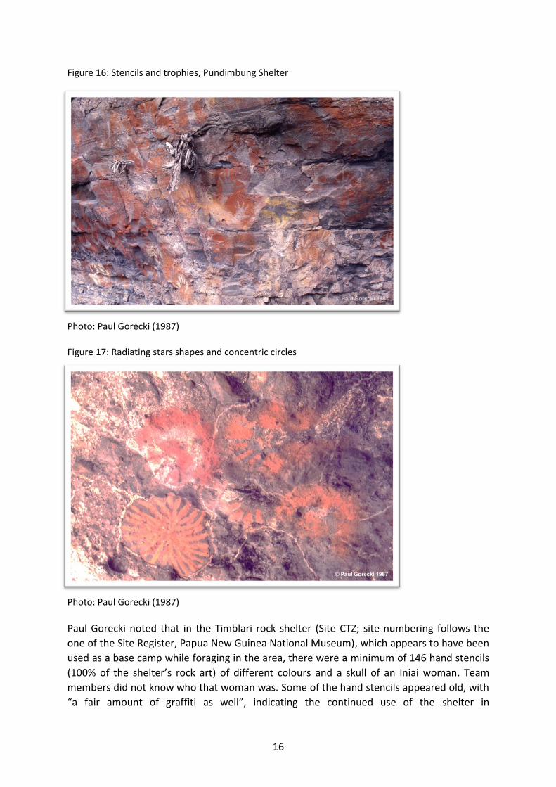
ritual art and ‘’relics’’. Panels of cave art (such as Figure 13 above), included geometric
designs, radiating stars and concentric circles (Figure 17), and cassowary daggers (Gorecki &
Jones 1987a). Paintings and stencils can be polychrome or of various colours. Objects of
various significance are left at many of the caves visited. For instance, at Pundimbung Cave,
stencils of hands were predominantly made with various red pigments, as well as white and
yellow pigments; in addition to this, the same site has a large collection of significant objects
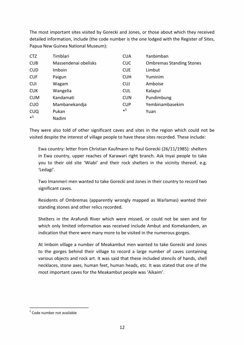
including hunting trophies (Figure 16).
16
Figure 16: Stencils and trophies, Pundimbung Shelter
Photo: Paul Gorecki (1987)
Figure 17: Radiating stars shapes and concentric circles
Photo: Paul Gorecki (1987)
Paul Gorecki noted that in the Timblari rock shelter (Site CTZ; site numbering follows the
one of the Site Register, Papua New Guinea National Museum), which appears to have been
used as a base camp while foraging in the area, there were a minimum of 146 hand stencils
(100% of the shelter’s rock art) of different colours and a skull of an Iniai woman. Team
members did not know who that woman was. Some of the hand stencils appeared old, with
“a fair amount of graffiti as well”, indicating the continued use of the shelter in

17
contemporary times. An interesting feature Gorecki observed was a number of branches
hanging over the activity area which are used to hang bilums, baskets etc (Figure 20). The
colour of the hand stencils varied, from red, yellow, pink, brown and other variations along
these base colours (Figure 18). It appears that the ochre was mixed to obtain the ‘right
colours’ (Gorecki Field Notes; 1987:78-80). No pottery or stone flakes were seen on the
shelter floor.
Figure 18: Various stencil pigments, Timblari shelter
Photo: Paul Gorecki (1987)
The floor of Timblari shelter had ample evidence of contemporary use, with numerous well
preserved fire places and an ash deposit (Figure 19). The wall and ceiling of the shelter were
covered with soot, but numerous organic remains were present. These included a broken
wooden comb and the bamboo string of a bow. Food remains included betel nut and
canarium shells (‘galip’).

18
Figure 19: Living floor at Timblari shelter
Photo: Paul Gorecki (1987)
Yanbimban (Site CUA) is another shelter heavily used during hunting and fishing trips. It has
sweeping views over the Yimas Lakes. At the time of its inspection, the shelter had five fire
places along a 50m ledge, and only up to 4m wide. Only 6 hand stencils (yellow and red)
were observed on the shelter wall. Its floor was littered with recent occupation activities.
Limbut shelter (Site CUE) was also most interesting, in part because of the story linked to it,
(but note that it seems to be a story identical to one recorded at Pundimbung; see below).
Gorecki and Jones could find only five hand stencils in this shelter. It is a sacred cave which
is inhabited by a spirit called Wandak. Although kina shells (mother-of-pearl shells) were
common here before the arrival of Europeans, one of these shells was particularly tied with
the spiritual history of Limbut. This kina shell was called Gemengain and was worn by
Wandak.
At the front of Limbut grows sacred bamboo. It was said that a long time ago people did not
make flutes with bamboo but with plain wood. The ‘cry’ of these flutes was limited. Two
men were living in the water, Kapon and Kupun. In reality they were bamboo disguised as
men. One day they planted the bamboo in front of Limbut shelter, put the great spirit,
Wandak, inside the bamboo and tied the kina shell Gemengain on it. Kapon and Kupun
talked to Wandak and then the flutes made from this bamboo had a good ‘cry’. Wandak
gave permission for the bamboo to be planted a many other locations.
Women can listen to the sound of the flutes but they are forbidden to see them. Today the
two men, Kapon and Kupun, still live inside Limbut, a shelter found right beside the
Arafundi. The kina shell Gemengain has been collected from Limbut and is now kept at
Imboin. Wandak lives now inside the shell.

19
Mendal (or Mental; Site CUG) shelter is another example of a secular location used as a base
for hunting and gathering activities. It consists of two narrow ledges, an upper one and a
lower one. It contained two fire places, one of these with an abundance of cooking stones. It
was clear to the party that a rather substantial meal had been prepared recently at Mendal.
No rock art was found at this site.
One of the shelters inspected by Gorecki and Jones, known as Paigun (Site CUF), was
particularly significant to one of the team members because this is where he was actually
born. Paigun also had a number of stencils of hands and objects, as well as memorabilia
belonging to a deceased woman. An additional significance of the site to the field member
was that at the front of Paigun his recently deceased elder brother made a stencil of his
hand on a tree (Figure 21). This is a very rare documented occurrence. The skull of the
deceased brother is now resting at Yuminim shelter (Site CUH). The strong links between
Paigun and Yuminim shelters, the team member, his birth, his mother and his brother are a
significant proof that the culture is alive and traditions are still followed and respected in
these caves and rock shelters.
The rock art at Paigun already existed when the team member was born and there is no
knowledge on who made it. It consists of 42 motifs, including numerous red stencils of
hands and feet, and two white stencils of hands. A number of red kina shell stencils, all of a
different size, were also present. One unusual circular stencil was interpreted as being of a
Conus shell ornament.
Some of the most important caves are highly inaccessible. Yembinambasekim shelter, for
example (Site CUP), once had a tree to climb down along its exposed roots to gain access,
but the tree was gone when Gorecki and Jones visited the area. The shelter is located high
above vertical cliffs and is known to be a sacred site. Another cave not easily accessible is
Pukan shelter (Site CUQ) which is said to contain bone remains in huge quantities of men,
women and children, as well as stencils (Jones Field Notes; 1987:114-115). It is said that
Pukan can be seen from Yembinambasekim.

20
Figure 20: Timblari rock shelter
Photo: Paul Gorecki (1987)
Figure 21: Paigun shelter – hand stencil on tree
Photo: Paul Gorecki (1987)

21
In caves imbued with religious power, uninitiated young men and all women were
forbidden. These restricted caves were often located in very remote sites and marked with
groves of sacred cordyline and bamboo (Gorecki & Jones 1987a:2-3). One such cave, Yuat
Cave was used exclusively by men and initiated boys. Women were not permitted in this
cave (Rhys Jones Field Notes, 1987:1). Another cave called Nadim was said to be Tambu
(taboo) and nobody was allowed to go there. At its base is a pink colour rock surface,
stained from the practice of penis piercing (Jones Field Notes; 1987:73).
Historically, young men would be secluded in rock shelters to learn sacred culture
knowledge and associated skills such as playing the flute or sago bark painting. Initiation
also involved having the urethra pierced with cane reeds, and the initiates would cover their
hands in blood and make hand stencils along cave walls (Sullivan 1998). In one of the caves a
“huge panel of blood stains” was noted. In another cave, Jones observed a pitpit tool for
piercing the penis, stored in a crevice within a “flute shelter” (Jones Field Notes; 1987:32). A
bamboo implement was used for piercing the urethra of the penis and spraying blood onto
the rocks (Gorecki & Jones 1987a:6).
The most remote cave visited, and one of the most important sacred sites is called Kalapul
(Site CUL), located after a six day walk from the archaeologists camp base, 800 metres up
almost vertical faces of wet rock (see cover photo). In his field notes in 1987 Gorecki noted
that the stencils in the cave (190 recorded stencils) were not recent and were made many
years ago. Among these stencils was one cowrie shell bilas (Pangalim), seven sea shell rings
(Kundumulem), and a rope of cowrie shells (Kablem). It also had paintings of radiating lines,
a bicolour ring (Kundumulem; with the inner ring in yellow ochre and the outer ring in red
ochre), and a cassowary foot. A minimum identification (with the assistance of team
members) of stencil motifs at Kalapul includes: 24 right hands, 31 left hands, 28 hands, 10
right hand and arm, 7 left hand and arm, 3 hand and arm, 2 finger ‘messages’, 6 kina shells,
1 shell nose peg, and 2 shell belts/ropes. Paintings included 16 geometric lines, 13 circles
and 18 red stains. For instance, Figure 22 illustrates three complex geometric figures,
including a form of ‘lattice’/chevrons at the top; one can also see numerous stencils of
hands and one shell bracelet.

22
Figure 22: Stencils and geometric paintings, Kalapul Shelter
Photo: Paul Gorecki (1987)
The cave was being used to perform ‘magic’, including poison and to conduct ritual dances.
The men played the male and female bamboo flutes while dancing. It was during these
dances that the paintings were made. “Some of these are dark red”, Rhys Jones noted: “This
is from human blood from the initiation ceremonies”. All the birds with dark red colours
were also said to have been created here, and then left for their respective environments.
Gorecki was told that all people in Papua New Guinea have their roots in this cave and no
woman had yet seen the cave (Jones Field Notes; 1987:100-104).
A slit-drum (garamut) was at the entrance of Kalapul. Once the cave was reached by the
Gorecki and Jones patrol, a smoke fire was lit and the garamut was beaten. This was
immediately acknowledged by the Namata village, a long way below the cave and across the
valley, from where one could hear a reply by the Namata garamut and one could see a
smoke fire rising. Gorecki and Jones recorded in detail a most important myth originated at
Kalapul but the story teller made it very clear that he wanted the myth to remain
confidential.
Gorecki and Jones were told that nobody is allowed to spend the night at Kalapul; as a result
the overnight bivouac was spent at Kandamati shelter (Site CUM), some 200m south of
Kalapul. This was a difficult night because the shelter was really only a 50m long cliff ledge,
and very narrow. Despite the rather dangerous aspect of the site, complex and distinctive
art was present on the wall surface, some of it being at incredible height given the narrow
width of the ledge. Kandamati had a range of painted geometric motifs. It also had one
painting of an animal foot with four digits. Some 3.5m above the ground there was a clear
stencil of a bilum. Stencils of the usual red hands were present as were stencils of hand and

23
arm. It included 7 left hands, 3 hands, and 2 left hand and arm. Six red stains (possibly
human blood) of a cultural origin were noted on the entire 50m length of the ledge.
Another important sacred cave is Pundimbung (Figure 23; site CUN), located high up on a
steep gorge (Gorecki & Jones 1987a:3). In Pundimbung shelter, small stone flakes were
found. These flakes, called Mamkas, were used for cutting the skin of initiates (Rhys Jones
Field Notes; 1987:68). 580 individual motifs were documented in this cave (Gorecki & Jones
1987a:6). Pundimbung cave contains a section for women, however in the main part of the
cave women are strictly forbidden. A sacred chamber was built on the side of the shelter in
which powerful and sacred objects were hidden from women and uninitiated men (Figure
24).
Figure 23: Pundimbung Cave
Photo: Paul Gorecki (1987)

24
Figure 24: Pundimbung sacred chamber
Photo: Paul Gorecki (1987)
In this chamber, sacred bamboo flutes were kept. The flutes were originally from the haus
boi (haus tambaran). After missionaries told the people to destroy the images of the spirits,
many sacred objects were destroyed and the men’s house was burnt, but the sacred flutes
were secretly kept in a cave until a new haus boi was built (Jones Field Notes; 1987:69). Old
bamboo groves were observed by Jones at this site, which was once an ancestral village.
Many caves are also repositories of sacred or important objects, smuggled there in the old
days without the missionary’s knowledge.
Following the overnight stay at Pundimbung, Gorecki and Jones were witness to a most
powerful moment, confirming the strong continuity of ritual practices among people from
the Karawari Caves Precinct. Two members of our party, young Auwim men, decided to
borrow the bamboo flutes from the sacred chamber. These men were at different stages of
initiation, one being allowed to play only the female flute while the other could also play the
male flute. They played and danced in that cave a number of different tunes, in a magic
theatre that was a shelter covered with rock art (Figure 25) and spectacular views over
lushed vertical gorges. Gorecki and Jones felt extremely privileged to share this unique
spontaneous experience.

25
Figure 25: Two men playing flutes in Pundimbung Caves
Photo: Paul Gorecki (1987)
Pundimbung cave is said to be the place from which all human language emanated:
There was once a time when the landscape had not been formed, there were no
people, there were no names and no languages. Only the two sacred bamboo flutes
existed, one male and one female, who inhabited the cave. In the time of creation,
they formed the landscape, made people, who then were dumb. To distinguish one
group of people from another, the two flutes gave languages to certain people and
placed them in a landscape, each speaking a different language. At the cave itself,
esoteric and secret male rituals were carried out, enacting and celebrating these
creation events (Gorecki & Jones 1987b:6).
One story about the sacred bamboo flute recounts a tale of a waterhole, a bamboo flute,
and two boys with the same names of the spirits Kapang and Kupun. The story ends with the
people being given a bamboo shoot to plant with instructions that when the old flute rots,
they should make new ones with this bamboo. Rhys Jones noted: “Now all the people have
kept these traditions” (Jones Field Notes; 1987: 53). This seems to be the same myth as the
one recorded at Limbut (see above).
Numerous bone dagger stencils were also present; these, usually made of cassowary or
human bone, normally reflect homicide events. But no such story was told to Gorecki and
Jones at Pundimbung. Overall a minimum of 562 stencils and 18 paintings were recorded at
Pundimbung. Stencils recorded include the following minimum number: 133 right hands,
141 left hands, 121 hands, 38 right hand and arm, 29 left hand and arm, 12 hand and arm,
12 right foot, 18 finger ‘messages’, 8 kina shells, 13 shell rings, 1 turtle bone, 2 megapode
foot, 2 dog paw, and 1 steel bush knife (machete). One unusual stencil was interpreted by

26
team members as being of a leaf used to wrap tobacco for a smoke; its local name is Mandi.
There was also a stencil of an edible leaf (Figure 26).
Figure 26: Edible leaf stencil – Pundimbung Cave
Photo: Paul Gorecki (1987)
A nearby cave (Yembinambasekim; Site CUP), with almost vertical cliff drops was used when
the village was occupied. The now extinct village of Ang-garik (or Angalip), also known as a
‘Big Place’, was located at the top of a cliffed peninsular and exhibited “extra-ordinary
defensive properties in the days of head-hunting” (Jones Field Notes, 1987:71). The location
of the former Angalip settlement is littered with pottery sherds, with an obvious presence of
pottery from the Chambri Lakes. This location was not a sacred site, it was a ples, a
settlement where there used to be two villages.
Gorecki and Jones, and members of the party could not climb down to Yembinambasekim, it
was now physically impossible to do so. It was stated that the cave contained rock art and
many important objects. Among these are 2 clay pots, 2 flutes, the male flutes made with
‘tulip’ wood while the female flute is made with kumba wood (these are the old types of
flutes). Women and children were not at all allowed to see these flutes. It is said that Pukan
shelter (site CUQ) can be seen from Yembinambasekim (site CUP).
Gorecki and Jones were told that the flat mountain top above Pundimbung was the original
settlement of the Inai people. Following some trouble at the head of Maket baret
(drain/canal), the Inai people left towards the Wogupmeri River. The Angalip people have
their origin at the head of Maket while the Inai people have their origin at Angalip and
Pundimbung.

27
The Spiritual Landscape The haus tambarans of the Karawari-Arafundi region, like the more elaborate versions along
the Sepik River, are places where groups of men perform the rituals and rites of passage
ceremonies that are believed to be of vital importance for the economic, political, and
ancestral well-being of the community. Haus tambarans such as those of the Yimas people
contained ritual objects including huge slit drums (garamut) adorned with carved crocodile
heads. They also contained ‘hook figures’ (Yi’pwons), said to be the personification of
hunting demons. The figures were pivotal to the preparation for war and hunting. Other
haus tambaran, such as at Auwim (Figures 27 & 28) and at Bambiang are covered by sago
bark paintings.
Douglas Newton also travelled up the Karawari River in the 1960s and collected artefacts
from caves (e.g. Hamson 2013; Newton 1971). Regarding the significant role played in the
region by Yimas, the anthropologist Douglas Newton (then director of the Metropolitan
Museum of Primitive Art, New York) made the following recommendation to Paul Gorecki:
I do recommend a visit to Yimas, the old village was abandoned probably about the
1940s. It is a spectacular site on 3 levels, with sunken ramp up the first used for
defensive purposes. The many monoliths around the top level are said to have been
originally painted and connected with divinatory dreams before raids. Altogether
there were 6 house tambarans. (Doug Newton, letter to Paul Gorecki, 23/4/1986)
Figure 27: Haus Tambaran at Auwim
Photo: Paul Gorecki (1987)

28
Figure 28: Sago bark painting at Auwim Haus Tambaran
Photo: Paul Gorecki (1987)
In 1964, an Administration Patrol noted bark paintings covering two walls of the men’s
house called Kumini at Arambro on the Upper Arafundi River. The patterns were said to
embody the spirits Wobo and Wangu (Amboin; Stobart 1/64-5, 1964):
… paintings in “Limbom” were brought back with the patrol destined for the “Haus
Tambaran” at ANGORAM. These covered 2 walls of the men’s house called KUMINI
at ARAMBRO. Although the patterns do not represent any specific feature of them,
they are supposed to embody the spirits WOBO and WANGU. These spirits were
created by KOBUNG, the ancestor of the area, while at the KAMBRIMERI GORGE,
after his journey form the SE (MARAMUMI River). KOBUNG gave these spirits to the
people of the area to idolize and form a basis for spiritual life (Amboin; Stobart
1/64-5, 1964).
The same spectacular Kambrimeri Gorge, upstream from Imboin, was many years later also
traversed by Gorecki and Jones (Figure 29). Wagam shelter (Site CUI) is found at the lower
entrance to Kambrimeri Gorge. Gorecki and Jones’ party spent the night in the shelter
during which there was an incident. Indeed, from a crack in the back wall of the shelter a
snake came out causing panic among sleepers. It was promptly killed and thrown in the
Arafundi just below the shelter’s entrance. Turtle fishing is said to be particularly good at
Wagam.

29
Some memorabilia of deceased women were in bilums left along the back wall. One of these
bilums with a sago frond cradle was one of those in which an infant was carried around. It
was stated that the baby had died, and as a result the bilum was left at the shelter. Exactly
the same event happened at Amboye shelter. Wagam had numerous hand stencils, mostly
in red, and also some paintings of chevron and parallel line motifs. Stencils included 5 right
hands, 16 left hands, another 16 unidentified hands, and 1 finger ‘message’, that is, a stencil
of fingers only interpreted by Gorecki and Jones (admittedly in a very subjective manner) as
being a ‘message’.
Ten hand stencils were recorded at Amboye (Site CUJ) The floor of the shelter had ample
evidence of recent occupation. Against the back wall were two bilums of deceased women.
One of these contained a wooden sago pounder. The other bilum had a segment of sago
frond which was used as a cradle to carry an infant (as it was the case for a bilum found at
Wagam shelter). Gorecki and Jones were told that the infant died, and as a result the bilum
was abandoned at Amboye shelter.
Figure 29: Archaeological party in 1987 resting at Kambrimeri Gorge with Wagam Cave behind the trees just above Rhys Jones (standing)
Photo: Paul Gorecki (1987)
Eike Haberland (1966:43-44) was the first European to record sago bark paintings among
the Penale people, when in 1961 he collected 26 bark paintings from the men’s house at
Auwim, which are now stored in a museum in Frankfurt. The bark paintings are associated
with initiation and played a pivotal role in preparing boys for adult spiritual life.

30
Patrol Officer T. Stobart outlined the significance of the paintings in processes of initiation:
During their initiation the young boys are kept in the house with the painted walls
for 2 months during which time they cannot be seen by women. If they go outside
and go they must, male relatives cover the initiate with their bodies. The reason for
the initiate staying inside the house apart from hearing all the legends and learning
the necessary skills of adulthood is to allow the spirits time to view him. After this
period there skin is cut and adult life begins (Amboin; Stobart 1/64-5, 1964).
In 1987, Paul Gorecki documented what he described as “quite an extraordinary haus
tambaran” containing named sago bark paintings covering all the internal posts and walls
(Figure 30), as well as geometric paintings on some ceiling beams, at a hamlet between
Yimas and Auwim called Bambiang (Gorecki Field Notes; 1987:86-87). This sacred house was
not built for the tourist trade but was entirely built for secular customs. Notes made by
Gorecki about these bark paintings are as follows, written down in a hurry:

31
Paul Gorecki’s notes on Bambiang Hamlet A most important myth as represented in a story of 9 bark paintings (sago bark)
PPG (5 September 2014):
This is a partial version of a most important myth found at least among the Auwim
people. I believe it is more widespread among communities in this region of the Sepik
basin. Among the Auwim people the myth is expressed through nine panels of paintings
drawn on sago palm fronds (Pangal). While passing through Bambiang Hamlet in 1987,
we were lucky to meet a man (Andreas Kandanbui) who was in the process of painting a
new set of nine panels about this myth. He was using natural pigments for this (see my
slides). Rhys Jones commissioned a copy of the first of these panels (Pendam
Nekimunga) and I did the same for the panel entitled Pendam, said to be the most
important in the story. The artist informed us briefly that these bark paintings illustrate
three important myths: bamboo flutes, water, and sun. Auwim Hamlet also has an
impressive Haus Tambaran; here sago bark paintings were made by Tikas Wapanapi.
From a visual perspective, it is Wuk, presented below as Panel 9, which is radically
different than the others and appears to be the most important of them all but William
Asanga insisted that it was Pendam, Panel 5 here, which is the most important.
William Asanga (he would have been in his early 20s then), who is from Auwim, took
part in all our patrols in the bush. He was kind enough to narrate part of the myth as
described on each of the nine panels (see below). I took these notes in a hurry, in a mix
of English and Pidgin. William also informed us (see for instance Rhys Jones’ notes for
the 1 June 1987) that in the old days the Auwim people did not make these paintings. It
was the Angalik people who did them (see my map for the rough location of the now
abandoned Angalik which was visited by us; it is further into the mountains south of
Auwim). It is only in the days when William’s father was a young boy that the Angalik
people came down from the mountains and merged with the Auwin people that the
Auwim people started to paint these boards.
Bambiang is located on the Arafundi, upstream from Yimas and Warlamas. It is at
Bambiang that we picked up the walking track leading up to Auwim. There is a
spectacular Haus Tambaran in Bambiang, with sago bark paintings covering all the walls
and the internal posts. A photographic record was made of this building (see Figures 30-
34).
Another central character in William’s story is a man named Kondem. He is at the origin
of all the bark paintings, the designs of each of these being based on stories or events
narrated to him by his own elders. Kondem is referred to as a real person who lived a
long time ago rather than as a spirit figure.
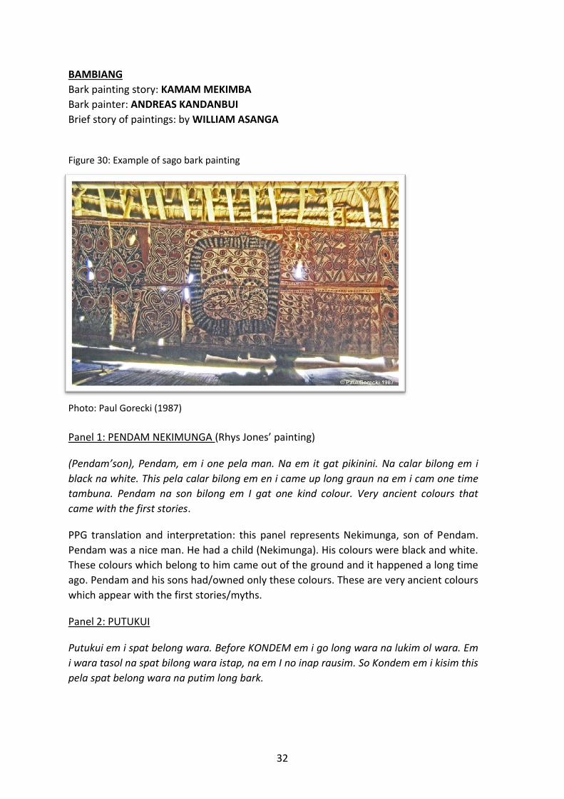
32
BAMBIANG
Bark painting story: KAMAM MEKIMBA
Bark painter: ANDREAS KANDANBUI
Brief story of paintings: by WILLIAM ASANGA
Figure 30: Example of sago bark painting
Photo: Paul Gorecki (1987)
Panel 1: PENDAM NEKIMUNGA (Rhys Jones’ painting)
(Pendam’son), Pendam, em i one pela man. Na em it gat pikinini. Na calar bilong em i
black na white. This pela calar bilong em en i came up long graun na em i cam one time
tambuna. Pendam na son bilong em I gat one kind colour. Very ancient colours that
came with the first stories.
PPG translation and interpretation: this panel represents Nekimunga, son of Pendam.
Pendam was a nice man. He had a child (Nekimunga). His colours were black and white.
These colours which belong to him came out of the ground and it happened a long time
ago. Pendam and his sons had/owned only these colours. These are very ancient colours
which appear with the first stories/myths.
Panel 2: PUTUKUI
Putukui em i spat belong wara. Before KONDEM em i go long wara na lukim ol wara. Em
i wara tasol na spat bilong wara istap, na em I no inap rausim. So Kondem em i kisim this
pela spat belong wara na putim long bark.
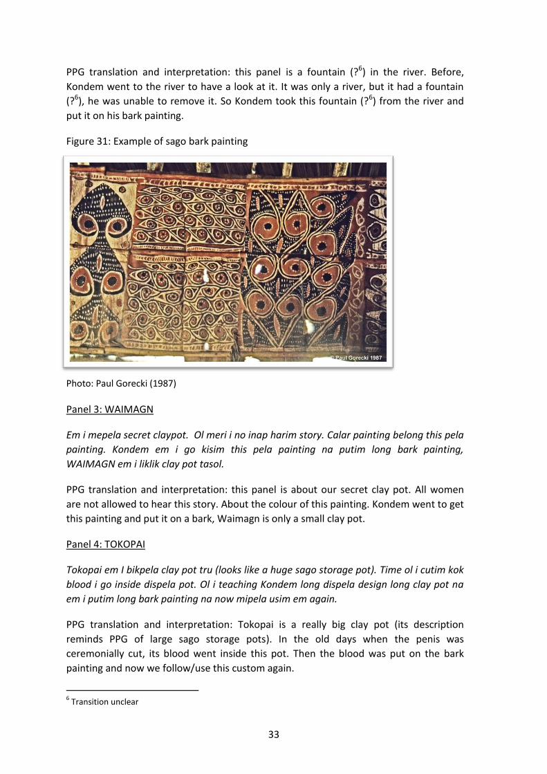
33
PPG translation and interpretation: this panel is a fountain (?6) in the river. Before,
Kondem went to the river to have a look at it. It was only a river, but it had a fountain
(?6), he was unable to remove it. So Kondem took this fountain (?6) from the river and
put it on his bark painting.
Figure 31: Example of sago bark painting
Photo: Paul Gorecki (1987)
Panel 3: WAIMAGN
Em i mepela secret claypot. Ol meri i no inap harim story. Calar painting belong this pela
painting. Kondem em i go kisim this pela painting na putim long bark painting,
WAIMAGN em i liklik clay pot tasol.
PPG translation and interpretation: this panel is about our secret clay pot. All women
are not allowed to hear this story. About the colour of this painting. Kondem went to get
this painting and put it on a bark, Waimagn is only a small clay pot.
Panel 4: TOKOPAI
Tokopai em I bikpela clay pot tru (looks like a huge sago storage pot). Time ol i cutim kok
blood i go inside dispela pot. Ol i teaching Kondem long dispela design long clay pot na
em i putim long bark painting na now mipela usim em again.
PPG translation and interpretation: Tokopai is a really big clay pot (its description
reminds PPG of large sago storage pots). In the old days when the penis was
ceremonially cut, its blood went inside this pot. Then the blood was put on the bark
painting and now we follow/use this custom again.
6 Transition unclear

34
Panel 5: PENDAM (Paul Gorecki’s painting)
No story.
PPG comment: although Pendam is the original character of this myth, William claims
that there is no story attached to this painting. At the time, PPG felt that either William
did not know the story or was not willing to tell the story attached to this painting.
Figure 32: Example of sago bark painting
Photo: Paul Gorecki (1987)
Panel 6: KINDIK
Em i go onetime hook mi Kisim (the hook I purchased at AUWIM). Before tru mipela i
nogat Kindik. First time ol i linim Kondem long calar belong bark painting, at the same
time ol i linim Kondem long sharpening diwai na wokim hook. Kondem em i go long wara
lookim ol dispela na em i lookim na putim hook long painting.
PPG translation and interpretation: this panel is about a hook similar to the one I took
(the hook I purchased at Auwim). A long time ago there was no Kindik. Then for the first
time they all told Kondem about the colour belonging to this bark painting, and at the
same time theu all told Kondem that he had to sharpen a piece of wood to make a hook.
Kondem then went to the river looking for this, found it and put it on the bark painting.

35
Panel 7: MATAIOMBA
Em i onepela kind saksak diwai. Em I sanap long front bilong haus boi long wara yet.
Calar belong hem em i cala belong pangal belong saksak. Em too Kondem I go kisim long
wara.
PPG translation and interpretation: this is a particular type of sago palm. It is standing in
the water right in front of the Men’s House. Its colour is the one of the palm fronds of
this sago. This too Kondem went to take at the river.
Panel 8: ETOKA ENUNGUKA
Em I hap mambu na inside long bel i gat design (mambu bilong shooting pig). Em too em
I mambu bilong wara na Kondem I kisim I kom. Ol I teaching Kondem na nau mipela I
wokim em yet.
PPG translation and interpretation: this is the half of a bamboo inside which it has a
design (the bamboo with which arrow tips are made especially for pig hunting). This
bamboo too is associated with water and Kondem went to get it and brought it back.
They all taught Kondem and now we are still doing it.
Figure 33: Example of sago bark painting
Photo: Paul Gorecki (1987)

36
Panel 9: WUK
Em i bigpela something tru i stap long basis (Whirlpool?). Putuku i stap inside Wuk, na
onetime snake. Na I save round round long basis. Sampela time em i save Kapsaitim
canoe, time wari I boil. Ol i have been linim Kondem long painting this pela something na
mipela usim i stap nau.
PPG translation and interpretation: this is something really big found in a whirlpool (?).
Putuku (PPG: could this be pukpuk instead, meaning ‘crocodile’?) lives inside Wuk,
together with a snake. They know how to go around and around this whirlpool.
Sometimes the can capsize canoes, when the whirlpool is strong (‘boiling’). They all
taught Kondem how to paint this and now we continue to do it.
See p. 28 on Wobo and Wangu. William says that there are the 2 flutes kept inside Haus
Tambaran. He calls them Wapaw and Wankung.
Figure 34: Example of sago bark painting
Photo: Paul Gorecki (1987)
PPG (5 September 2014): about previous comment, see my slides of William Asanga and
Otto Katuk playing and dancing with male and female flutes in a most sacred
rockshelter (Pundimbung; see various notes and slides about this site).

37
Figure 35: Bambiang Haus Tambaran
Photo: Paul Gorecki (1987)
Carved Spirit Figures Spirit carvings, once stored in rock shelters and caves, are said to be representations of
ancestral beings intimately linked to the landscape. One such figure (now in the ‘Kauffmann
collection’) represents one of the mythical ancestral sisters whose deeds made the surface
of the earth habitable for humans by creating the valleys, and, in an encounter with the
spirit of the forest up on the mountain close to the sources of the rivers, to have discovered
the utility of the sago palm (Kauffmann 2003:24-25). Gorecki and Jones (1987a; 1987b) were
shown important stone carvings of spirit figures at a village called Amongabi, on the
Karawari River (Figures 36-39).

38
Figure 36: Carving of Tamarat spirit
Photo: Paul Gorecki (1987)
Figure 37: Carving of Enu spirit
Photo: Paul Gorecki (1987)
Figure 38: Carving of Bowi spirit
Photo: Paul Gorecki (1987)
Figure 39: Carving of Mareri spirit
Photo: Paul Gorecki (1987)

39
Figure 40: Sacred carving in Pundimbung Cave (Auwim Territory)
Photo: Paul Gorecki (1987)
Over the past 40 years important and potentially ancient carvings, mortuary relics, hunting
amulets, and other portable artworks have all been removed from caves and shelters to sell
to international art dealers. The carvings that remain are in poor condition due to
weathering (Edwards & Sullivan 2008:20).
In the 1950s-1960s many of the stone carvings and other figurines, said to have come from
the caves in the hinterland were sold to art dealers from villages at the foot of the hills.
Alfred Bühler, then the director of the Museum für Volkerkunde in Basel (now the Museum
der Kulturen) was the first anthropologist to visit the upper Karawari in 1959, followed a few
years later by Eike Haberland (University of Frankfurt), who wrote about the carved hooked
figures from the cave shelters after a total of five days spent in the settlements of Auwim,
Warlamas (or Kapokmeri), Imanmeri, Yamandim, and Imboin in 1961 and 1963 (Haberland
1964; Roscoe & Telban 2004:96).
The carvings were created by the Inyai-Ewa people, and rock shelters provided suitable
places for the figurines (Figure 40 above). Before every minor or major hunt the hunter
would call upon the individual ‘helper figure’ to assist him—each woodcarving according to
Inyai informants is said to have a soul of its own—and the hunter would attempt to harness
the soul of the carved figure to achieve success in the hunt (Kaufmann 2003:23).

40
By 1966 Patrol Officer M.V. O’Regan noted that many of the stone carvings and wooden
carvings stored in the caves had already been sold to traders:
At Iniai village I investigated the claim that 2 European traders from ANGORAM
have been buying stone carvings from the people. As a result of the investigation it
was learned that the traders in question, are buying these carvings from prices
varying from 5 dollar to 50 cents. I also learnt that these stone carvings are being
collected by the people from the many caves that are to be found at Mt Kabrimeri
at the back of Iniai village. The people also told me that they were also finding very
old wooden carvings in these caves. These wooden carvings are also being sold to
the traders. It is a great pity that these valuable artifacts are being removed from
the caves (Amboin; O’Regan 1966-7).
Following the sale of spiritual carvings ranging from five dollars to 50 cents, Patrol Officer D.
Van R. Claasen called for protection of the caves, and recommended the area be declared a
national park (Kauffmann 2003:1).
The sacred sculptures that were traded to international art dealers are considered unique
because they originate from numerically small population groups in a remote part of the
Sepik region, and because of their clarity of expression and variety of forms (see Kauffmann,
2003:27).
The carvings stored in the rock shelters are said to be representations of ancestral beings
intimately linked to the landscape. One such figure (now in the Kauffmann collection)
represents one of the mythical ancestral sisters whose deeds made the surface of the earth
habitable for humans by creating the valleys, and, in an encounter with the spirit of the
forest up on the mountain close to the sources of the rivers, to have discovered the utility of
the sago palm (Kauffmann 2003:24-25).
The hooked figures (called either aripa or yipwon, depending on the shape and perhaps
purpose) had once been kept in the haus tambaran as part of hunting ritual for attracting
good fortune on the hunt. Later, they were brought to the rock shelters and small caves
above the settlements where the figures could connect the hunters and their families with
the game that was much sought after. Here, the hooked figures resided, undisturbed for
decades and centuries protected from the elements by the rocky hills.
Carvings from this river tributary traded to collectors have enriched museum collections in
New York and Europe. These include sculptures of life-size ‘’cult’’ crocodiles, the ancestral
animal of the Sepik region. 105 carvings from the Karawari river tributaries (including head
sculptures and male and female figures), formed the “Eike Haberland collection” which was
catalogued in 1968. Their age has been estimated at between 10 and even 20 generations,
and individual figures may have been carved in a period extending roughly from the 16th to
19th century, well before the arrival of Europeans.

41
Haberland described the older carved figures of the Upper Karawari caves (which show a
striking irregularity and asymmetry), “as an example of an ancient, extinct culture of New
Guinea”, adding:
To be accurate about the age of this cave sculpture is rather difficult. At any rate,
they are old. It seems likely that the hard wood they are made of, protected by
sheltered caves from variations of temperature and humidity, should have survived
for hundreds of years (Haberland 1964:ix).
The sculptures were described in 2003 as potentially “the oldest of all known works by
Melanesian carvers” (Kauffmann 2003:27). Notably, the variety of form in the carvings is
said to be indicative of the people’s readiness to make constant changes (Ibid: 27). Carbon-
14 dating of a ceremonial bowl in the “Jolika collection” (Figure 41) dates the wood to the
period 1520 to 1810.
Several other pieces have been dated to the period 1630-1810. Two other aripa hooks bear
even earlier date ranges of 1410-1640 and 1480-1670, respectively. Many of the objects
that have been sold to collectors are estimated to be between two to three hundred years
old (Welsch 2013, Christies Auction House).
Some of the Karawari carvings are in the hands of private collectors who specialise in buying
and selling antique New Guinea art. One such object, described as a ‘’Karawari Charm’’
(Figure 42) is held by a private gallery called “New Guinea tribal Art”.7
7 http://www.new-guinea-tribal-art.com/wp/index.php/2011/11/01/new-guinea-art-wanted/

42
Figure 41: Ceremonial bowl at Christies Auction
Source: http://www.christies.com/lotfinder/sculptures-statues-figures/bol-ceremoniel-a-
ceremonial-bowl-haut-karawari-5685350-details.aspx
Figure 42: Karawari charm
Source: New Guinea tribal Art.com

43
Ongoing Research, Activism and Management Today the Penale people of the Upper Arafundi and Kawarari region are working to preserve
the history of their people– and small groups of the Meakambut (Figure 34) are continuing
to live the life of their forebears. The people have been working on the documentation
project with anthropologist Nancy Sullivan (Karawari Cave Arts Facebook site) since 2007
and have recorded many of their own stories and collected much of their own data about
the caves in an ongoing effort to keep their forest free from intruders and maintain their
traditions (Kararawi Cave Arts8, May 13, 2014). By documenting the caves, the people are
engaging in land management strategies to protect the caves and rainforest against
potential development impacts such as mining and logging.
Active protection of the caves commenced with the Karawari Cave Arts Project, which began
the conservation effort in 2008, as before that a lot of looting and destruction had occurred
in these caves. The concerted and deliberate efforts of local people and Nancy’s Sullivan’s
team working together since 2007 to find and document all the caves, educate the region
about their importance, and learn more about the costs of development and conservation
more generally, were all supported by Christensen Fund, Give2Asia, The National
Geographic Society, Rainforest Norway Foundation, the Guggenheim Foundation and so
many more supporters. In 2008, the conservation efforts generated an archaeological
expedition by Antonio Cruz Mayor with personnel from Nancy Sullivan and Associates (NSA)
and a team of participants from Easter Island, Chile, who visited caves in the Upper Karawari
and Upper Arafundi area (including Pundimbung cave in Auwim) to conduct ethnographic
and archaeological research.
8 Nancy Sullivan Facebook page https://www.facebook.com/pages/Karawari-Cave-Arts/490820780965116

44
Figure 43: Contemporary research
Edwards & Sullivan (2008)
Figure 44: Meakambut at Imboim hamlet
Photo: Edwards & Sullivan (2008:5)
Nancy Sullivan with her team of fieldworkers and local assistants are continuing to gather
stories and genealogies pertaining to these sites. Some of the caves are little more than
rough ledges, with a bare minimum of rock art, while others offer an impressive panorama
of stencils and paintings (Edwards & Sullivan 2008:29). Around 300 caves and rock shelters
have been located to date, and there is ongoing work to photograph and record all of these
(Figure 45). The ethnographic data collected is reconstructing some of the migration
histories of the people in these three separate tributary regions, and in this way helping to
establish some of the land tenure precepts that can help the Penale defend their rainforest
and the caves that have sustained them for generations.

45
Figure 45: Documenting the caves of the Upper Karawari
Photo: Karawari Cave Arts Facebook (2014)
Saving the Caves: Notes from the Field, by Nancy Sullivan In March 2013, we discovered that a joint Malaysian-Australian company had applied for a
mineral exploration license over an area that would cover most of the Karawari caves. A
helicopter had dropped down into an Upper Arafundi River village with PNG Mineral
Resource Authority representatives and a couple of Australians in early March, as the first
and only sign of what was afoot. The cave owners with whom we have been working for 7
years quickly mobilised to create a consensus against this plan, which sounded like a done
deal before any informed consent could be mustered. In April 2013, representatives from
the Penale tribe, from the Alamblak, Ewa and other Upper Karawari-Arafundi communities
came together in Namata, high above the majority of these caves, where people still depend
entirely on their bush and are largely semi-nomadic. These historically under-represented,
some would say ignored, peoples came together for a weekend meeting that represented
the first coalition of these many cave peoples. It was impressive. All the Big Men of the
Upper Karawari were there: Matthew Kongop represented Namata and Imboin; Jack Yulaso
was there for the Meakambut; Eddie Nambu for the Imanmeri; Albert Simi for the
Yamandem and Wombromus villages; Mika Wapi from Moinene, represented the Ewa;
Matteos Paul and Luke Raymond were there for the Andimbit faction; James Martin for
Kupin; Ipare Wapale from Awarim; Simeon Tika from Kaiam; Bonny Mapat from Yimas;
Solomon Yakaman from Imboin; and Simon Yambori represented the Karawari Rural LLG
Council. 541 landowners signed an anti-mining petition that weekend, and from that, was
launched an international petition in support of these people, and their desire to stay on

46
their land, to live and improve their lifestyles as landed peoples, not displaced refugees. The
international GoPetition9 focused on the need conserve the 300+ caves that may date to
antiquity and have unknown potential importance to the history of Melanesia, and the
world. This petition quickly garnered 1092 signatures and prompted the PNG Minerals
Resources Authority to refrain from issuing the exploration licence. The actions by the
Upper Karawari-Arafundi communities to protect their caves are in many ways a
continuation of their efforts since the 1960s when they first tried to prevent contact by the
Australian administration.
Figure 46: Namata meeting
Photo: Nancy Sullivan (2013)
9 No mining the Karawari caves. http://www.gopetition.com/petitions/no-mining-the-karawari-
caves/signatures.html

47
Chronology of Research
1959 – Ethnologist, Alfred Buhler, conducted a fieldtrip to the upper Korewori in 1959.
Bühler, who was director of the Museum für Volkerkunde in Basel (now the Museum der
Kulturen) was the first anthropologist to visit the region. ("Kultkrokodile vom Korewori,"
Zeitschrift für Ethnologie 86, pp.183-207, 1961).
1964 - Prof. Eike Haberland wrote about the hooked figures in a 1964 article ("Zum
Problem der 'Hakenfiguren' der südlichen Sepik-Region in Neuguinea," Paideuma 10,
pp.52-71). Haberland and Siegfried Seyfarth wrote a more extensive ethnology of this
region (1974: Die Yimar am oberen Korewori (Neuguinea). Studien zur Kulturkunde,
vol.36). Eike Haberland's The Caves of Karawari (New York, D'Arcy Galleries, 1968)
shows dozens of carved hooked figures of approximately a metre or more in height.
These figures, carved from timber were found in caves and rock shelters of the upper
Korewori River, a tributary of the middle Sepik.
1973 - Kaufmann (2003) details a study expedition to the area in 1973. After the
Museum der Kulturen had acquired most of the known hooked figures, the Basel
anthropologist Christian Kaufmann and his wife Annemarie Kaufmann-Heinimann visited
the region to help document the collection (see Ethnographische Notizen zur Basler
Korewori-Sammlung: Aus den Ergebnissen der Sepik-Expedition 1972/73, Verhandlunger
der Naturforschenden Gesellschaft in Basel 84, pp.711-725, 1974).
1987 – Archaeologists and anthropologists Paul Gorecki and Rhys Jones conducted the
first systematic exploration of numerous caves and rock shelters, documenting ten
major rock art friezes associated with religious and other cultural customs. Their
confidential report recommended National protection of the general area of the sites.
(‘A New Rock Art Province in new Guinea’, 1987).
2004 - Anthropologists Borut Telban and Paul Roscoe conducted a survey of some of the
foraging societies in the lower Arafundi basin related to the Korewari people (The
People of the Lower Arafundi: Tropical Foragers of the New Guinea Rainforest,
Ethnology 42(2), pp.93-115, 2004).
2005 – Anthropologist Nancy Sullivan began visiting the hill caves and shelters and
started working with the Penale people to document and record the sites. (Sullivan, N.
1998. “The Awim Caves,” Paradise, Air Niuguini in-flight Magazine 129:23-25; Sago Bark
Painting and the Transformation of Community Identity on the Arafundi River (Pacific
Arts Journal 12(2):5-23, 2012).
2008 - Edmundo Edwards and Nancy Sullivan and their team conducted short-term
ethnographic and archaeological work in some of the caves. (Preliminary Report of the
Cruz Mayor Rock Art Expedition to Papua New Guinea. May -July, 2008).

48
Reference Material Bühler, Alfred. 1961. Kultkrokodile vom Korewori, Zeitschrift für Ethnologie 86, pp. 183-207. David, Bruno and Wilson, Meredith. (eds) 2002. Inscribed Landscapes: Marking and Making
Place. Honolulu, USA: University of Hawaii Press. Edwards, Edmundo and Sullivan, Nancy. 2008. Preliminary Report of the Cruz Mayor Rock
Art Expedition to Papua New Guinea. May-July, 2008. An Explorers Club Flag 83 Expedition http://www.explorers.org/flag_reports/Edmundo_Edwards_Flag_83_Report.pdf
Filer, Colin. 1990. Diversity of Cultures of Culture of Diversity? In N. Lutkehaus et al (eds) Sepik Heritage: Tradition and Change in Papua New Guinea, pp. 116-129. Bathurst, Australia: Crawford House Press.
Foley, William A. 1991. The Yimas language of New Guinea. Stanford,USA: Stanford University Press.
Forge, A. 1959a. New Guinea Diary, May 12th to August 8th. Papers of Anthony Forge, MSS 411, Box 9, Folder 4. San Diego.
_____1959b. Typed notes: Karawari. Upper River. 24/6.5. Papers of Anthony Forge, MSS 411, Box 7, Folder 20. San Diego.
Gorecki, Paul. 1987. Upper Karawari and Arafundi Field Notes – Unpublished report, ANU. Gorecki, Paul and Gillieson, David (eds) 1989. A Crack in the Spine: Prehistory and ecology of
the Jimi-Yuat Valley, Papua New Guinea. Townsville: James Cook University. Gorecki, Paul and Jones, Rhys. 1987a. A New Rock Art Province in New Guinea. Internal
Report not for circulation. Department of Prehistory. Research School of Pacific
Studies. Canberra: Australian National University.
_____1987b. Rock Art of the Upper Arafundi and Upper Karawari Rivers, East Sepik
Province. Preliminary Report October 15, 1987. Department of Prehistory, Research
School of Pacific Studies. Canberra: Australian National University.
Haberland, Eike. 1964. Zum Problem der 'Hakenfiguren' der südlichen Sepik-Region in
Neuguinea, Paideuma 10, pp. 52-71.
_____1966. Zur Ethnographie der Alfendio-Region (Sudlicher Sepik District, Neuguinea).
Jahrbuch des Museum fur Folkerkunde zu Leipzig 23:33-67, Tafeln X – XIV.
_____1968. The Caves of Karawari. New York: D'Arcy Galleries.
Haberland, Eike and Seyfarth, Siegfried. 1974. Die Yimar am oberen Korewori (Neuguinea).
Studien zur Kulturkunde, vol. 36. Weisbaden: Franz Steiner.
Hamson, Michael. 2013. Collecting New Guinea Art: Douglas Newton, Harry Beran and
Thomas Schulltze-Westrum. Los Angeles: Michael Hamson.
Jones, Rhys. 1987. Upper Karawari and Arafundi Field Notes. Unpublished report, ANU.
Kaufmann, Christian 1974. Ethnographische Notizen zur Basler Korewori-Sammlung: Aus
den Ergebnissen der Sepik-Expedition 1972/73, Verhandlunger der Naturforschenden
Gesellschaft in Basel 84, pp. 711-725.
Kaufmann, Christian. 2003. Korewori—Magic Art from the Rainforest. Translated from
German by Robert Williamson. Exh. cat. Basel: Museum der Kulturen; Belair, SA,
Australia: Crawford House.

49
Lutkehaus, Nancy, Kaufmann, Christian, Mitchell, William, Newton, Douglas, Osmundsen,
Lita, Schuster, Meinhard (eds) 1990. Sepik Heritage: Tradition and Change in Papua
New Guinea. Durham, North Carolina: Carolina Academic Press.
Newton, Douglas. 1971. Crocodile and Cassowary: Religious Art of the Upper Sepik River,
New Guinea. New York: The Museum of Primitive Art.
O’Regan, M.V. 1967. Patrol Report 5/1966-7. Amboin Patrol Post.
Redmond, H.J. 1961. Patrol Report 2/1961-2: Karawari and Wogupmeri Rivers. Amboin
Patrol Post.
Redmond, H.J. 1962. Patrol Report 3/1961-2: Karawari. Amboin Patrol Post.
Roscoe, Paul and Borut Telban. 2004. The People of the Lower Arafundi: Tropical Foragers of
the New Guinea Rainforest. Ethnology, 42(2):93-115.
Schuster, Meinhard. 1990. Aspects of the Aibom Concept of History. In N. Lutkehaus et al
(eds) Sepik Heritage: Tradition and Change in Papua New Guinea, pp.7-19. Durham,
North Carolina: Carolina Academic Press.
Smith, S.H. 1967. Patrol Report 6/1966-7: Arafundi. Amboin Patrol Post.
Stobart, J.T. 1964. Patrol Report 1/64-5: Upper Arafundi. Amboin Patrol Post.
Sullivan, Nancy. 1998. The Awim Caves, Paradise, Air Niuguini in-flight Magazine, 129:23-25.
_____2012. Sago Bark Painting and the Transformation of Community Identity on the
Arafundi River. Pacific Arts Journal, 12(2):5-23.
Swadling, Pamela, Hauser Schaublin, Brigitta, Gorecki, Paul and Tiesler, Frank. 1988. The
Sepik-Ramu: An Introduction. Papua New Guinea National Museum, Port Moresby.
Welsch, Robert. 2013. A Ceremonial Bowl Haut-Karawari (Korewori), Moyen-Sépik, Province du Sépik Oriental, Papouasie Nouvelle-Guinée, 1520-1810. Christie’s Auction House, Paris. http://www.christies.com/lotfinder/sculptures-statues-figures/bol-ceremoniel-a-ceremonial-bowl-haut-karawari-5685350-details.aspx
50
Special Acknowledgements
The Arafundi River Communities for their generosity in providing superb assistance,
knowledge and stories to Paul Gorecki and Rhys Jones during their fieldwork in 1987.
The PNG National Museum and Art Gallery for their advocacy and protection of Papua New
Guinea’s cultural heritage.
Paul Gorecki for his detailed field-notes, digital slides, fieldwork memories, generous
support, and diligent attention to detail in co-authoring this paper.
Rhys Jones for his detailed field-notes and photos. We hope this paper honours your work in
the Arafundi region.
Bill Foley for his invaluable advice on people from the Arafundi River and for the use of his
field base at Yimas.
Nancy Sullivan for her ethnographic knowledge, dedicated support and ongoing research
undertaken through the Karawari Cave Arts Project
(http://www.globalgiving.org/donate/24116/the-karawari-cave-arts-project/info/)
(http://www.jcu.edu.au/cairnsinstitute/info/resources/JCU_078529.html)
Matthew Leavesley for his review of the report and extensive knowledge of PNG
archaeology.
Michael Wood for his review of an early version of the report and constructive comments.
The Cairns Institute, James Cook University, for providing the institutional support for
research, editing and publishing.