The Journal - Lorton & Derwent Fells Local History Society
16
The Journal No 46 – August 2010 Brackenthwaite Buttermere Embleton Loweswater Mockerkin Pardshaw Wythop www.derwentfells.com Lorton & Derwent Fells Local History Society
Transcript of The Journal - Lorton & Derwent Fells Local History Society

The Journal No 46 – August 2010
Brackenthwaite Buttermere Embleton Loweswater Mockerkin Pardshaw Wythop www.derwentfells.com
Lorton & Derwent Fells Local History Society

2
The Journal
A very good response has followed my request for articles from members, and so in this issue we have a wide variety of topics for our readers. It is particularly good that Roger Asquith has been able to present a satisfactory but surprising solution to the puzzle of the location of Loweswater’s corn mill. However, members should note that the properties involved are on private land which the Society does not have permission to enter. I do hope for more articles for January, though perhaps there will be space to squeeze in another property history. Derek Denman Editor
Contents of Journal No. 46 From the Chair 2 A Visit to Low Stanger Farm 2 Why is Cockermouth a ‘Georgian’ Town and who is ‘Jack’ Robinson? 4 A Walk through Loweswater Village in the 1950s 8 In Search of Loweswater’s Corn Mill 10 Corries in Cumberland 15 The Society’s Programme 16
From the Chair The AGM on June 10 saw changes to the Committee, with Michael Baron and John Scrivens stepping down. Michael was our longest standing committee member, serving over ten years and including terms as Chairman, Vice Chairman and arranger of talks. He worked with Hetty on the Three Valleys Oral History Project, and has played a large part in the success of the Society’s published books. The Committee was delighted to make Michael an Honorary Member of the Society as a token of our gratitude. John Scrivens will also be much missed. He organised the Society’s first House History Group, he ran a very successful poetry competition in 2004, and has organised and led several memorable outings – one involving a boat
trip across Coniston Water to John Ruskin’s house at Brantwood, and another visiting the charcoal blast furnace and the bobbin mill in south Lakeland. In place of Michael and John we were pleased to welcome two new members, John Macfarlane and Roy Oxlade. The Committee also announced its decision to co-opt Bernie Ewels. I am grateful to our new members for agreeing to join the Committee, and I am confident that the new team will work effectively together. John Hudson Chairman
L&DFLHS 2010-11 President Dr Angus Winchester Financial Examiner Les Polley
Officers and Committee 2010-11 Chairman Dr John Hudson Vice–Chairman Derek Denman Secretary Sandra Shaw Treasurer Christopher Thomas Committee members:- Anne Asquith Membership Sally Birch House History Group Ted Gilbertson Talks John Hart Archive Dr John Macfarlane Roy Oxlade Bernie Ewels (co-opted) Landscape
History A Visit to Low Stanger Farm by the House History Group on 9th June,
courtesy of Peter and Michelle Kerr Members present: Sally Birch John Hart John and Judy Hudson Peter and Michelle Kerr Tim Sowton and Eileen Palmer Jim and Jean Williams Our fifth visit was to Low Stanger Farm. Peter and Michelle are members of the Countryside/Environmental Stewardship Scheme run by Natural England and so the visit proved to be mutually beneficial as this is the kind of activity the scheme seeks to promote.

3
We started with a visual inspection of the old farm buildings – byres and a barn. Peter had removed some of the more recent rendering on what he assumes is the oldest byre but the patchwork of old beck stones revealed in the process raised as many questions as it provided answers in terms of how the buildings had originally appeared and evolved. Some of the chamfering over the entrance doors indicated considerable antiquity and higher status usage whereas other features were Victorian and definitely agricultural rather than domestic. The doors had formerly opened inwards, hinting that at least one of the byres may have originally been a very basic cottage or even a hovel, prior to being assigned to the beasts. Similarly, traces of lime-wash on beams and also walls in the haylofts were more in keeping with human occupation. However, Peter and Michelle are not committing themselves at this stage and hope more will come to light in due course. An old cobbled floor was revealed beneath centuries of debris in a small room to the rear of the building, opposite what may be a former buttery, and this same room contained a brick-built Georgian hob-grate with a somewhat incongruous brick chimney rising up from the corresponding corner of the roof outside. Another rather puzzling feature is the staircase which springs from the ground in stone but suddenly turns into wood. Possibly it may once have been outside? Peter intends to make further use of the old byres after introducing a few 21st century mod cons to accommodate 21st century cattle which tend to be bulkier than their 18th century antecedents. What he is really keen to do is to ensure the continuing use of the buildings but he is then confronted by the problem of consolidating them without destroying any of their integrity and period features, removing inappropriate cement render and replacing like-for-like only when absolutely essential. After this, we changed into wellies and struck out across tracts of ancient farmland while Peter pointed out odd-shaped boundaries and evidence of
Low Stanger Farm around 1890
centuries of cultivation (deep drops at field margins, visible rig and furrow etc.). We then ventured across the “fen”, complete with a track-way whose origins lie in the mists of time. It was an enchanting spot – part of the perennial view across the valley from the Lorton Road we all enjoy after foraging in Sainsbury’s and yet at the same time hidden, unfamiliar and other-worldly. Accompanied by the plaintive cry of the curlew, we reached St. Anne’s Well, the once famous local spa, and speculated whether the name Stanger is a corruption of St. Anne. We mostly preferred this theory to the notion that it is of Norse origin. Next, we made our way intrepidly (or rather ‘trepidly’ in my case) back across the fen, startling a roe deer in the process. Peter and Michelle led us to some cattle troughs which had been engineered by local philanthropist William Alexander in the nineteenth century. He, like many another indomitable Victorian, was determined to overcome nature’s shortcomings by draining these wetland areas to provide what would no doubt have been very rich cattle pasture. The land has now reverted to fen but substantial traces of his valiant attempts at conquering the wilderness still survive. On our return to the house, we were shown some interesting and historic documents relating to the history of this

4
small settlement with maps, an aerial photograph and a very useful account of the historic drainage systems in the Lorton area which, in the light of recent events, may well prove invaluable. We had a brief wander through the main part of the farmhouse, noting a 1722 date stone over what had been an external doorway which is now blocked up and part of the downstairs loo! All this energetic detective work seemed to stimulate the taste buds and we were treated to a welcome cup of tea and the most delicious home-made cake and biscuits – thank you Michelle! A very detailed history of the farm and those who worked it, dating back to 1635, has already been put together for Peter and Michelle by Sheila Stayte, whose account featured in the August 2008 edition of The Journal and so the story scarcely needs repeating here. For those who would like to read it but have jettisoned their back copies of The Journal, the Society’s archive under the aegis of John Hart, can oblige. Suffice it to say here that Low Stanger Farm dates back at least to the seventeenth century and for much of that time it was in Quaker hands. Its raison d’etre has changed over the years, being at one time used for arable and meadow as well as pastureland and it is actually an amalgam of three cottages – hence the now defunct entrance with the date stone referred to earlier. As a result, it has been associated with many different owners and tenants and the present custodians, Peter and Michelle, are devoting themselves to making a success of an organic market garden and an environmentally friendly farm/ smallholding. The House History Group is grateful to them both for the cordial way they welcomed us and gave up a good three hours of what we came to realise is their extremely precious time. It also occurred to us as the visit progressed that a visit to the farm could be something that the members of the Society at large might well be interested in as a mini excursion – possibly next year – so perhaps Peter and Michelle will have to give up even more of their time but in the spirit of the Natural England Scheme, I somehow don’t think they will mind! Sally Birch
Why Cockermouth is a ‘Georgian’ town and who is
‘Jack’ Robinson? by Michael Baron
Cockermouth boasts, with reason, of its Georgian architectural heritage. Nicklaus Pevsner in his magnificent series of the Buildings of England praised it in the Cumberland and Westmoreland volume; and it is one of 51 Gem Towns, designated by the British Archaeology Survey of 1965. Why and how does one Cumberland enjoy a distinction that amongst other things enables it to host a heritage-centric ‘Georgian Fair’? Of course 18th century townsfolk knew the crowds around the regular hiring fairs, saw and heard real travelling musicians, dancing bears, and actors, some busking in the streets. But adding to that, say, a ‘Mediaeval Fayre’ would have been a laughable fantasy. Busy making money from tanning, hat making, milling, fulling, and the general commercial and agricultural trade of a market town, they had no time for backward looks, but relished the excitement of hustings for parliamentary elections, and the accompanying quantities of free booze. In that ‘Georgian’ time -1714-1832- from the accession of George I to the Great Reform Bill- 278 electors had the franchise to return two members to Parliament. Not quite the rottenest borough or the most corrupt ‘pocket borough’ in England, where the prize was held by Dunwich in Suffolk where 8 electors returned two members- although most of the mediaeval borough was under the North Sea. The principal residents of another borough, Old Sarum, were a flock of sheep.
In 1700, Cockermouth was a post-mediaeval town, spread out on both sides of Cocker Bridge. Most of the houses would be two-storey, with thatched roofs and of timber and plaster construction, and in style similar to the present-day Percy Gallery, or to the cottage that houses the reception foyer at Wordsworth House. What might be described as the original old town was Market Place, Kirkgate and St Helens Street. There was no Waterloo Street; no development on the North bank of the Derwent; and no development south of South Street, then known as Back Lane. A hundred years earlier, there was no High

5
Sand Lane, and the land between the back of the Main Street burgage plots and the Derwent was known as the Waste or the Sands. ‘The sandy fields, leaping through/ groves of yellow groundsell” as Wordsworth remembered in Book I of The Prelude. When the fields flooded when river levels rose, there were no buildings to be damaged, hence the first report of damage by flood seems to be as late as 1752. A town with castle, church, school, market, innumerable inns, industry, and, in the time covered by this article, a population of around 6,000.
Appleby -in-Westmoreland was not dissimilar. Another ancient riverside borough, it also returned two members to Parliament, had a castle, market, an excellent grammar school (a mediaeval foundation like Cockermouth), and a fine main street, Boroughgate. In Appleby the Robinsons were a prominent family, taking their customary turn at the mayoralty, and sending sons into the professions, the Church and the Navy. Seven miles away in Maulds Meaburn was the seat of a branch of the Lowther family. They were intent on acquiring wealth and power in Appleby and elsewhere in the two counties. John “Jack” Robinson was born in 1727 to a Robinson, who was a successful merchant, and after school was articled to the Sockbridge solicitor, Richard Wordsworth, (married to his aunt). Richard, William Wordsworth’s grandfather, was in 1745 the land and law agent and steward of the Lowther estates. The family relationship led to Robinson, once qualified, joining his uncle in 1751 as joint steward, and becoming a ‘Lowther’ employee.
Described by historian, Ian Christie, as ‘attorney, country gentleman, member of parliament, and ancestor of the Earls of Abergavenny, John Robinson’s career illustrates a certain social mobility not at all uncommon’. Yeoman becomes gentleman, then law and politics beckons and is followed by government service. At the peak of his career (when the Cockermouth years were long past) representing Harwich until his death in 1802, he was a junior Treasury Minister (perhaps akin to today’s Chief Secretary). One of a group known as ‘the King’s Friends, he lived in style in Hanover Square with a fine new country house in Isleworth. He married off his only
daughter to an Earl. At other times he had been M.P. for Appleby, a Justice of the Peace, Mayor, and a Lieutenant-Colonel in the Westmorland Militia. Until a quarrel in 1774, doing the bidding of Sir James Lowther, has been, personal abilities apart, the reason for Robinson’s worldly success, in influence and wealth
The stewardship of substantial estates was a well trodden path to gentry status, as the Lawson family discovered in the course of first their management and second their acquisition of the Manor of Loweswater in 1625. So when Richard Wordsworth died in 1760, Robinson became sole steward, of the expanding Lowther regional empire. Land and law agent, he became an figure in Cumberland and Westmorland, notwithstanding the comments of Sir Anthony Abdy in a 1759 letter to the Duke of Devonshire that he was ‘a dirty attorney of Appleby...[and]....I am satisfied that no good can come from the advice of such creatures’.
By 1784 the ‘dirty attorney’ known at Westminster as ‘rat-catcher’ Robinson was managing elections for George III, who was determined to use the Royal Prerogative to get a government of his choice. Nowadays royalty has to mess with planners and oil emirs. Meeting the King once when both men were riding through Kensington, the monarch said to Robinson (the latter’s self-serving account) ‘you are always steady, you do not change with the times’.
In 1756, Sir James Lowther was 21 and had just inherited immense wealth from his cousin of Whitehaven. The press might have written then ‘with a golden cash flow, he can eat up any opponents, and squeeze all other.....guarantee him the political hold over any government..‘ (The Guardian on Rupert `Murdoch-29th June 2010). Other inheritances had enriched him so that he had acquired voting control of the two Appleby seats. Like Carlisle and Cockermouth, these were burgage boroughs, the parliamentary voting rights lying with the burgage holders who established title by the production to the mayor of the deeds. A vote was an asset, a saleable commodity, which could be exercised in the borough’s best interests, but to a rich man the means of appointing nominees to the House of Commons and exercising influence on legislation and the

6
formation of governments through them. Early in his quest for power, Lowther had acquired 24 burgages in Cockermouth. Controlling Appleby was not enough .
In April 1756 an anonymous appeal was published in Cockermouth, reminding electors of their rights and their value and that they should only sell these in the best interests of the town to the highest bidder. Research may well show that this wheeze was dreamed up by Lowther and Robinson. The latter is now the man of business in Cockermouth. The senior steward, Richard Wordsworth, was aged 66 and in poor health and probably unfit to do this task. The spinners of the appeal will have known the attraction of money for the 278 electors. Most likely they and their clerks knew them personally.
Lowther wanted those two seats, and a by-election might soon be called. Robinson went to work, and it is eay to imagine him button-holing men in the inns, at social gatherings, or in his office, the present Wordsworth House, and doing deals. To buy for £58,060 (£500,00 ) 134 burgages must have taken much patience, energy, charm, organisation, time. and many bottles of wine.
A Mr Walker is reported to have got £4500 for eight burgages in Main Street, The Sand and St Helens Street. His deal would be but one of the many sets of title deeds to be examined; conveyances to be completed; money to be transported, secured and paid. (Lowther was still owing money for six burgages at his death in 1801). Historians of the purchase refer to the ebb and flow of the dealings and the competition with the Earl of Egremont’s agent for burgages. None seem to have considered the extent of the management of this purchase and the time to complete 134 transactions, but it would have been considerable perhaps going into 1757 with John Robinson as the directing executive. He was then 29 years old. And this is his account to Lowther of April 15, 1757.
‘There are 7 houses fixed for the entertainment of your friends; viz, the Globe, Mr.Dixon’s, unlimited, the House late John Lucock’s, Ordinary 130- Wine 10 Dozen. Punch and ale propertionable-Two others at 50 ordinarys each- one of them allowed 4 dozen of Wine and punch and
ale, and the other ale and punch proportionable. It is proposed also to have 13 other houses for taking off the lower class as may be from the better houses ... besides likewise some ale from the other houses for the mob. These means it is hoped may lessen the expense at the great houses where it is hard to run high by the rabble getting in and stealing and carrying off all the liquor they could...’ (Note: The Globe, although closed and sad in the aftermath of the floods, was the principal inn/hotel of 1757. Lucock’s house is Wordsworth House which Robinson bought as agent for Lowther in 1761, and conveyed it to Lowther in 1764 ) This by-election was for one uncontested seat.
Lowther and Robinson had done well and waited for the next round. With his 158 burgages controlling Cockermouth (and providing the same bribery of drink as recounted in the April 1757 note) the March 1761 general election saw the Lowther nominees, Charles Jenkinson (later Lord Liverpool) and Sir Thomas Mordaunt (who sold several burgages to Lowther), duly returned.
Jenkinson’s son, the 2nd Lord Liverpool, was Prime Minister from 1812-1827) though Disraeli described him as ‘the arch mediocrity’; others would say ‘arch reactionary’ who supported the Manchester magistrates in the panic event known as the Peterloo Massacre of 1819. Only very old men in Cockermouth would have remembered the Prime Minister’s father, the first ‘Lowther’ MP. And so it remained until the Great Reform Act swept the rotten boroughs away.
Lowther now has a lot of property, acquired between 1745 and 1761. The voting rights were the prize, not the real estate. So the next task of John Robinson is to lease out the properties for Lowther. Only a comparison of the names of the sellers of the burgages with the names on the leases will reveal how many properties were leased back to the original burgage holders and how many to tenants and developers. There could be at least 200 houses and commercial buildings held on 999 year leases from 23 June 1761 at the yearly rent of one shilling. There are no restrictions on buiiding or alterations; the only power reserved to the lessor who is, nominally, John Robinson is to require notices of assignment to be served on him

7
or his successors. Perhaps there was some understanding.- my man gets elected, you get your property back but in a different form. The proximity of the long lease dates with the March 1761 general election is not a coincidence.
Now, there is money in hand from the sale of voting rights, and a building lease at a nominal rent. Stone for building is available from local quarries, as well as slate for roofing. Take Obadiah Yates who has sold his burgage in Kitty Went (Challoner Street). The title deeds indicate this property has been in his family since 1676. Other Kitty Went deeds date back to 1623, as do deeds in St Helens Street (and earlier). Assume that Yates and the others were living in old houses- even with thatched roofs, and timber and plaster fronts and that Lowther has no interest in evicting them, since that was never the motive of his transactions. So Yates has the means, the incentive and the freedom to modernise his house within the old burgage boundaries. He might alter or rebuild. Stone is in and builder and stonemasons have picked on the latest fashion. Lucock had set an example when his house was built in 1745, leaving as an indication of what had gone before the simple cottage that now houses the reception foyer to the Wordsworth Trust. Once, the only stone building in Cockermouth was the Castle. How does a town become ‘Georgian’? It requires money, old buildings to renovate, housing need, desire to show off, freedom of planning, the possibility for profit, and secure property titles. Cockermouth has over 200 Grade II listed properties. The dates on the listing records are approximate- early/mid/late 18th century. Only the Castle and Percy House have earlier dates. But the layout of the town on the map of 1600 shows all of Market Place, Castlegate, Kirkgate, St Helens Street, Challoner Street and Main Street. The 17th century town has all but disappeared and been transformed. Or has it? A visit to the Castle Bar (formerly the Ship) reveals a wealth of timber, an interior stone staircase, and plaster decorations. It is, as advertised, a 17th century house with a Georgian facade. The corner shop ‘Lilys’ at 28 Market Place has some interesting internal features and is held on the 999
Detail from The first Levee of the new P-r-t, 1784. ‘Ratcatcher’ Robinson, is shown with a rat on his forehead. The lines attach to the
King’s bare posterior, an image not in keeping with the house-style of the Journal.
From George III, a life in Caraicature by Kenneth Baker
year lease of 1761. It is likely that all the Market Place facades date from after 1756 and many from after 1761. When I put out a request for ‘Cockermouth’ lessees to contact me there was a poor response but it is evident from the 200 or so title deed sets at Carlisle Record Office that there are that number of leases in Cockermouth; and that 1757 to 1775 are key date in its development. Behind many Georgian facades lurk remnants of the houses shown on the 1600 map. Even so, many will have been demolished and a new house built post 1761. There are also 1761 leases of land only- for example, of Tarn Close, now the site of Sainsbury’s.
My unproven thesis is that Sir James Lowther and his agent, John Robinson, were the unintended developers of 18th century Cockermouth. The search for regional power by Lowther, and its efficient implementation by Robinson, over 1756-1761 was the catalyst for change. There is a straight line from them via the ‘Gem Town’ title, to the Georgian Fair, and the town’s often regressive wish to keep everything ‘Georgian’. The townsfolk of the

8
mid -18th century did not want to keep it as it was. Busy, thrusting, money making, entrepreneurial, necessarily corrupt, people then wanted change, and grasped the opportunity that these two men gave them.
Robinson’s daughter did become Lady Abergavenny. Both Abergavenny and Robinson were investors in the East India trade. That procured John Wordsworth a cadetship in the East India Company’s fleet. His cousin, Richard Wordsworth of Whitehaven (who later retired to Branthwaite) was the captain of the merchant vessel ‘The Earl of Abergavenny’ And John, the poet’s younger brother born in the house once owned by John Robinson, was its captain and drowned when the ship foundered off Portland Bill in 1805. Only connect!
The Lowther Estate have not lost interest in the town. A recent letter has this: ‘I would confirm that the Estate still holds the freehold reversion of the long leases, awaiting ultimate reversion’. Ultimate reversion is 2760. They have a long wait.
Sources: Cumbria Archive Service -Files- D. Lons W9/10/1- 196 The Story of Appleby. Holdgate, 2006 The Second Tory Party. Feiling 1955 J. Robinson ‘State of the House of Commons.1780 The Political Allegiance of John Robinson, 1770-1784. Christie 1956 Myth and Reality in 18th Century British Politics, Christie. 1970 The Lowther Family. Owen, 1990 Sir James Lowther. Bonsall. 1950 Wordsworth A Life. Barker, 2000. The Hidden Wordsworth, Johnston .1998 ODNB- John Robinson. Cannon 2004 -Leases of 28-30 South Street, 34 St Helens Street, 2 Mayo Street, 9 Waterloo Street- 23rd June 1761 (NOTE: I have only examined 9 of the 196 files of title deeds in Carlisle.. Other relevant papers -accounts, receipts, etc around the 1756 burgage purchase, the Robinson dealings as land agent, and the 1761 leases may be in the Lowther Archive. Other material on the events of 1756 will be in the Cockermouth Castle Archive. My conclusions are therefore speculative and more investigation is a necessity)
A Walk through Loweswater Village in the 1950s
by Walter Head Reflecting on how my birth village of Dean had changed since I was a youngster, I decided to put pen to paper and write a description of a walk through the village in the 1950's. Following this I contacted friends ‘of that certain age' in other villages who agreed to do likewise. The following is the first of a series of such descriptions. Please remember that although I am confident that the details are correct they are the result of 60 year old memories. As always any additional information and/or corrections are welcome. Approaching Loweswater from the direction of Mockerkin we pass. on the left hand side, the water reservoir which stored water from Holme Beck high above Holme Wood and supplied water to the local villages around Mockerkin and Dean. Just past this in a field on the left hand side was the disused and boarded-up MOCKERKIN SCHOOL. Built in 1781, it closed in 1899 (see LHS Newsletter from 2004 Nos. 31.32 and 33). At this time the building was still in reasonable condition, with the old long school desks clearly visible inside. Further on at the junction of the road to Lamplugh, on the right hand side was FANGS FARM, a glebe farm owned by Loweswater church and farmed by John and Annie Armstrong, who also ran a small shop selling sweets, lemonade etc. Down the hill towards Loweswater and along a short road on the right hand side was IREDALE PLACE FARM, farmed by John and Amy Shields who also ran a small mink farm. Just past Iredale Place Farm was IREDALE COTTAGE home of Mrs Spencer, and then JENKINSON PLACE farmed by John and Sally Armstrong, who also catered for bed and breakfast guests. Back on the road and continuing down the hill, near the bottom and reached by a winding lonning on the left hand side was GRAYTHWAITE FARM farmed by Wilson and Elizabeth Barrow. At the bottom of the hill a narrow farm track on the right hand side led up to THE PLACE FARM farmed by A.M. Wilkinson. Next to this was HUDSON PLACE, farmed by Robert and Francis Mitchell. Back on the road again and just passed this junction on the left hand side was the GRANGE COUNTRY HOTEL owned

9
by W. Norman. Next also on the left hand side was WATEREND FARM, farmed by Daniel and Hannah Leck who also ran a milk round providing milk for the local population. Adjacent was WATER END FARM COTTAGE occupied by Mrs Corde who was of Dutch origin and who always wore wooden clogs. Opposite the farm entrance on the right hand side of the road was WATEREND COTTAGE occupied by Mrs Walker who was a teacher at the Sunday School . Continuing along the road a track on the left hand side led up to the ruins of SPOUT HOUSE, a “Jerry Pub". Here the track divided; to the left was ASKHILL FARM farmed by Mr and Mrs Sanderson then Thomas and Agnes Jackson, and to the right was MIRESYKE FARM, farmed by John and Freda Lightfoot. Back on the road again, the next property on the left hand side was LOWESWATER HALL lived in by Mrs Gate. Further along the road on the left hand side was Loweswater PINFOLD, a holding area for stray sheep. Next on the left hand side was CRABTREE BECK, occupied by Mrs Gardner and Mrs Morrison. Then at the top of the small hill on the left hand side was THRUSHBANK FARM farmed by Mr and Mrs Willis, and above this on the fellside was HIGH THRUSHBANK occupied by Norman & Norma Tallentire. The farm buildings were used by Mr Willis. Next, past the end of the lake on the left hand side, was HIGH CROSS FARM farmed by Daniel and Lizzie Fearon. Further along the road and past
the junction on the left hand side to Thackthwaite, but on the right hand side was LOWESWATER SCHOOL built in 1839 and closed in Dec 1948: it is now the village hall. The last pupils at the school were Doris Leck, Betty Sanderson, Michael Shields, David Vickers and William Vickers. The school teacher, Mrs Watson, lived above the school in LOWESWATER SCHOOL FLAT. Still on the road and below the school on the left hand side was the wooden OLD VILLAGE HUT, and below that also on the left hand side was the VICARAGE where the vicar was Geoffrey White. At the bottom of the hill on the left hand side was ROSE COTTAGE lived in by Esther and Bella Beck who ran a sweet shop. Then on the right hand side at the junction was the OLD SMITHY which ceased to operate in the late 1940's. Opposite this on the other side of the junction was OAK COTTAGE home of David and Elsie Norman. A path past Oak Cottage led to GILLERTHWAITE, where the village post office was run by Ada Coulthard. At the Old Smithy junction the road signposted to the Church led to St. BARTHOLEMEW’S CHURCH on the right hand side, and across the junction opposite the church was the KIRKSTYLE INN, run by Mr and Mrs Stagg. A road below the inn on the right hand side led to KIRKHEAD HOUSE on the right, occupied by Mrs Prince, past this on the right was KIRKGATE FARM, farmed by Isaac Todd. Further on up the old fell road were the ruins of Bargate Farm. Back at the church the road down the small hill continued to a junction, and

10
turning right the road led to LOW PARK and LOW PARK. COTTAGE. These were occupied by Mrs Alexander and James Cullen. Further on was HIGH PARK occupied by Mrs Ethel Irwin, known for her spinning of yarn and whose daughter played the church organ. Next was MELBREAK COTTAGE occupied by Arthur Barnes. Back at the junction the road continued round to MUNCASTER HOUSE on the left, an old farm house lived in by Thomas and Maggie Norman. Next on the right hand side was the remains of the OLD COBLERS SHOP and then on the left, just before the crossroads, was JENKIN HILL occupied by Mr and Mrs Ainsworth. At the crossroads the road to the right led to SCALE HILL BRIDGE, while straight across on the left was GODFERHEAD FARM, farmed by William Rawling, and GODFERHEAD COTTAGE occupied by Gordon and Marjorie Stagg. Further along the road on the right hand side was NETHER CLOSE FARM, farmed by Mr H Vickers, then on the left hand side, up a short lane, was MOSS COTTAGE, occupied by William Statter. (This was the local collection point for rose hips collected by children at 3d per pound. ) Moss Cottage was originally the office of the Loweswater Mine Company (see LHS Newsletter No 36 from 2005). Further along was a ‘T' junction, and turning left the next property on the right was FOULSYKE HOUSE the home of Wentworth and Madelaine Robinson, and then FOULSYKE COTTAGE occupied by Joseph Tolson. Continuing along the road at the crossroads, going straight across a narrow road led down to Maggie’s Bridge and a farm track on the left just before the bridge led up to HIGH NOOK FARM farmed by William and Jeannie Hope. Back across the bridge, and across the fields, a track led to WATER GATE FARM farmed by James Chamley. Further on in Holme Wood beside the lake was the uninhabited HOLME WOOD BOTHY, a pleasant location to end this particular walk . Acknowledgement A special thanks to Doris Richardson (nee Leck) without whose help this article would not have been possible. Thanks also to Dick Bell and Harry Spencer for their help to Doris.
In Search of Loweswater’s Corn Mill
by Dr Roger Asquith
Some background and history. In 1789 John Head inherited, as well as Turner How, the ‘Brackenthwaite and Loweswater Mills with their kilns’. His recent forebear, also John Head, had itemised in his will of 1772 ‘the Corn Mill and Kiln which I lately purchased of Sir Gilfrid Lawson situated and being in the parish of Loweswater’1. (The Lawsons of Isel & Brayton had been Lords of the Manor since 1624, although at different times they leased it to others). According to manorial court records Joseph Skelton was in 1756 ordered to repair the ‘hiway on the south side of Stockbridge leading from the said Lord’s Mill’2, (Stockbridge being in the vicinity of Maggie’s Bridge and the present NT car park). These pointers support the conclusions that the manorial corn mill lay within the Mill Hill tenement (this being the part of the Head family estate to the south of Stockbridge) and that it survived until the late 18th Century. Prior to Henry VIII’s time the Manor of Loweswater had been held by the Earls of Northumberland. They surrendered lands including their Loweswater holding to Henry, who granted it to Richard Robinson around 1545, the letters patent relating to the transaction specifically referring to ‘one corn mill and one fulling mill’ in Loweswater manor3. The corn mill was a particular bone of contention during the protracted legal wrangling between the Patricksons (Anthony and Henry, father and son, as subsequent Lords of the Manor) and their tenants. This rumbled on for about 40 years. At the outset the tenants of the various holdings claimed joint ‘tenantright’ to the mill, giving them access and use. As court judgements and various agreements came and went, the arrangements would change between tenants’ obligation to use the mill (at a specified ‘multure’ or cost, e.g. 1/24 of the corn ground) and freedom ‘to grind their corn at any mill of their choice’.4 One particular agreement settling the tenantright litigation was executed ‘at the mill’ in June 1619 with more than 30 tenants present.

11
Life in old Loweswater notes that more than a century earlier, in 1488, Robert Hodgson had been fined in the manorial court for having his corn ground at another mill. An earlier mention of Mill Hill concerned the tenant John Jackson being fined for poaching in 1457, while the earliest mention of the fulling mill, at Bargate, related to rents payable to the Earls of Northumberland in the year 1439. Although the possibility of other mills, fulling or corn, within the manor of Loweswater cannot be discounted, the principal mills serving the community for a period of 350 years or more up to 1800, were those at Bargate (fulling) and Mill Hill (corn).
The elusive corn mill. While the whereabouts of the Bargate fulling mill is well defined by the 1st Series Ordnance Survey maps, the actual corn mill has taken on a somewhat elusive character, in spite of Mill Hill being clearly marked on the same maps. Mike Davies-Shiel, in his ’Watermills of Cumbria’ 5 (subtitled ‘a detailed study of corn mills’), touches briefly on the windmills of the county. Loweswater mill is included on a distribution map entitled ‘Known Windmills of Cumbria’.
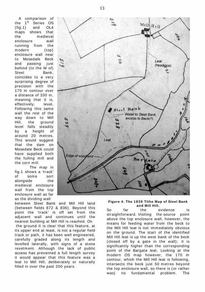
Figure 1. Leats of Mill Hill, Steel Bank and Bargate in 1863. Based on First Series OS
map. While the text indicates that this was one of 38 windmills surveyed by J. Hughes 6, that particular reference only mentions a Loweswater windmill in the context of ‘may have existed’ based on place name evidence suggestive of ‘an elevated situation far removed from a known water course’. Mike Davies-Shiel seems to have reached his own firm conclusion regarding a windmill on Mill Hill. Although the main text of Life in old Loweswater speculates on the question of the type of mill associated with Mill Hill,

12
Figure 2. The buildings at Mill Hill, from 1st
Series OS map, 1863.
Figure 3. Enlargement from fig. 1, showing point of transition from upper leat to lower
leat (headrace to Mill Hill) Derek Denman’s editorial footnote leaves little room for doubt: ‘The myth of the Loweswater windmill has no substance other than the name Mill Hill. While the millers house was at Mill Hill, the mill itself, the Lord’s mill, would have been near the foot of Mosedale Beck’. Archive
documents relating to the Patrickson era make just one or two references to ‘the water corn mill’ 7 – for the most part they just say ‘corn mill’ and give no clue as to the specific location within the manor boundaries. A mill by Mosedale Beck having good access for the local population might logically be sought where the old route of the track to Mill Hill (1st Series OS map, e.g. ref. 2, page 132) runs close to the lower reaches of the beck. There are, however, no indications on the available maps of either a building or the substantial leat that would have made it possible. Lack of public access unfortunately precludes walking the banks in search of signs that might predate the maps.
Mill Hill revisited. ‘There’s an old mill by the stream….. Nellie Dean…!!!’ appears on the title page of Watermills of Cumbria, a well known line that reinforces the notion that a watermill is not to be found on a ‘dry’ hillside. The assertion or assumption that there was not, and could never have been, a water course at Mill Hill itself, however, does not 'hold water'. On the OL4 (The English Lakes, North-western area) 2008 Ordnance Survey map, the remnants of Mill Hill farm sit exactly on the 150 metre contour. Bargate for comparison, is just a touch lower at about 145 m. The leat to the fulling mill at Bargate
can be traced on the ground and is marked on the 1st Series OS maps (fig.1). It led from Mosedale Beck just above the present enclosure wall (at the edge of the open fell) at an elevation of almost 170 m, giving a fall of nearly 25 metres. This point on the beck is therefore 20 m (65 ft.) higher than Mill Hill, adequate head, in principle, for a watermill. Feasibility clearly requires there to be a suitable ‘line’ for a leat on the ground.
13
A comparison of the 1st Series OS (fig.1) and OL4 maps shows that the medieval enclosure wall running from the modern (top) enclosure wall near to Mosedale Beck and passing just behind (to the W of) Steel Bank, coincides to a very surprising degree of precision with the 170 m contour over a distance of 330 m, meaning that it is, effectively, level. Following this same wall the rest of the way down to Mill Hill, the ground level falls steadily by a height of around 20 metres. This would suggest that the dam on Mosedale Beck could have supplied both the fulling mill and the corn mill. The map in fig.1 shows a ‘track’ of some sort alongside the medieval enclosure wall from the top enclosure wall as far as the dividing wall between Steel Bank and Mill Hill land (between fields 872 & 836). Beyond this point the ‘track’ is off set from the adjacent wall and continues until the nearest building at Mill Hill is reached. On the ground it is clear that this feature, at its upper end at least, is not a regular field track or path, it has been well engineered, carefully graded along its length and levelled laterally, with signs of a stone revetment. Although the lack of public access has prevented a full length survey it would appear that this feature was a leat to Mill Hill, deliberately or naturally filled in over the past 200 years.
Figure 4. The 1839 Tithe Map of Steel Bank
and Mill Hill. So far the evidence is straightforward. Visiting the source point above the top enclosure wall, however, the means for feeding water from the beck to the Mill Hill leat is not immediately obvious on the ground. The start of the identified Mill Hill leat is up the west bank of the beck (closed off by a gate in the wall); it is significantly higher than the corresponding point of the Bargate leat. Looking at the modern OS map however, the 170 m contour, which the Mill Hill leat is following, intersects the beck just 50 metres beyond the top enclosure wall, so there is (or rather was) no fundamental problem. The

14
apparent difficulty now, in 2010, is a consequence of substantial erosion caused by water and feet. At this position we would expect there to have been a weir or dam of some height, with excess water over spilling to continue down the beck. Two possible indicators of this on the ground are a section of substantial wall foundation on the east bank at right angles to the beck and a deep 'hole' in the beck bed at a point where the overspill may have impacted (as underneath a waterfall). The problem of feeding water to a mill wheel at Mill Hill is therefore just the same as that of feeding the mill at Bargate, and the solution appears to be essentially the same. The mills were of the same era under the same Lord of the Manor, the Earl of Northumberland. As water mill engineering options the two arrangements provide a constant head at the source (i.e. the dam), a controllable flow in times of flood/drought as well as protection from flash flood events. Altogether better siting for mills than on the low ground near Park Beck. Some obvious questions. Why would the corn mill have been built in a relatively elevated position so far from the beck, giving both a long headrace and tailrace? Both Steel Bank and Mill Hill appear unusual in the Loweswater area in that they both lack a natural water supply. Most if not all farms and houses of a similar age have a water course or well close by. It is a reasonable supposition therefore, that the mill leat also fulfilled non-mill (i.e. farming and domestic) needs, enabling these two farms to be established when the mill and the leat were constructed in, or before, the 15th Century. (A consequence of this dependence of the farms on the mill leat for a water supply, and possibly on both mills to support maintenance of the dam, may well have been the decline of both farms once the mills became redundant.) Derek Denman has proposed that the siting of the two farms is consistent with them being part of the medieval ‘ring dyke’, where farms were aligned along the edge of the enclosed land, thus ensuring the security of the enclosed land, while providing direct access out on to the
common (waste) where stock had to be grazed during the crop growing season. Names such as Watergate and Bargate are associated with the major access points out on to the common. (Clearly the limit of the enclosed land was further down then than it is today as a result of further enclosure in the intervening period.) This wider view of the needs of the manor thus provides a rational basis for the chosen location of the corn mill, which could otherwise have been situated almost anywhere on the west bank of Mosedale Beck. Why would the leat have been horizontal (following the fixed height contour) as far as the farm at Steel Bank? Construction of more than half the leat along the 170 m contour clearly required more exacting standards than a leat with a steady fall. Where there are two independent users in line on the same leat, the arrangement would be essential, ensuring a constant water level in the upper section of leat (i.e. matching the level in the dam, which is fixed by the height of the weir). The downstream user, Mill Hill, would control their flow by a sluice arrangement on the low side of Steel Bank without affecting Steel Bank, who would independently regulate their off-take by means of a sluice on a side branch. Close study of the Steel Bank/Mill Hill boundary on the map (fig.1) points to this being the location of the corn mill sluice. Here the double dotted lines on the Mill Hill side might indicate an offset, separate section of leat with sluice controlled transfer from one to the other. An enlarged section of the map at this point (fig. 3) reveals a small square symbol or feature aligned with the leat. This level of detail on an 1863 map and the fact that all the Mill Hill buildings were still ‘occupied’ might indicate that the leat continued in use after the corn mill ceased operation (c. 1800). Does this mean the mill was perhaps adapted for another use (saw mill perhaps) or just that the water supply to the farm was maintained? What might be deduced regarding the mill itself?

15
It would appear (fig.1,) that the headrace followed the ‘track’ to a mill wheel on the north end wall of the east building of the three at Mill Hill. Over a period of 350 years it is possible that significant alterations and developments to the building, the machinery and the wheel type occurred. The location of the kiln could also have changed – initially, perhaps, being separate from the mill, later incorporated into the same building. It is just as possible that little was done beyond the essential maintenance and repair, so the mill in its final days could have been of a somewhat primitive type. Further research into manorial corn mills of the era may prove enlightening. What has not been addressed so far is the tail race beyond Mill Hill. This does not affect the issue of the viability of a watermill in this position, but it would be interesting to know where it was. Normally it would take the most direct route back to the beck; in this case best use of the water would need to be made regarding domestic and agricultural needs. However, there is no indication or suggestion of the route on Ordnance Survey or Tithe maps, nor even by the wonders of Google Earth. The 1839 Tithe map, interestingly, while generally not showing farm tracks, includes the Mill Hill head race ‘leat features’, as well as two features leading from the leat at Steel Bank down to the beck (fig.4). The latter would be consistent with water conduits supplying Steel Bank and returning the excess to the beck – traces of this arrangement are visible on the ground. Speculation regarding mill and leat details is likely to remain just that unless or until a proper survey can be carried out. At present there seems little prospect of the necessary permission being granted. Summary. i) Loweswater’s manorial corn mill was
a watermill sited at Mill Hill. ii) It was one of two mills in the manor
operating from the mid 15 C, possibly before, until c.1800, the other being the fulling mill at Bargate. Both used water from a dam on Mosedale Beck above the present enclosure wall.
iii) The confusion regarding the position of the corn mill arose as it did not fit
the ‘old mill by the stream’ stereotype and because of the ‘Mill Hill’ name usually associated with windmills.
iv) The siting of the mill enabled two farms, Mill Hill and Steel Bank to be established on ‘dry’ high ground on what was the edge of the enclosed land in the late medieval period.
v) Although the above conclusions seem to be well founded, access to Mill Hill land would further confirm and add to the understanding of this historic mill.
References. 1. Wills of Richard Head of Hope (1784)
and John Head of Turner Howe (1772), courtesy of Janet Jacobson.
2. Life in old Loweswater, Roz Southey, 2008. LDFLHS publication.
3. Certified copy of letters patent of Henry VIII, D LAW/1/239.
4. Copy (c.1700) of ‘Indenture’ dated Nov. 1619. D LAW/1/255.
5. Watermills of Cumbria M. Davies-Shiel, Dalesman Books 1978.
6. Cumberland Windmills, J.Hughes, C.W.A.A.S. Trans. Vol. 72 pp112-141.
7. Copy of translation of Chancery decree dated 15 June 1597, D LAW/1/258.
Acknowledgement. Derek’s assistance and support in providing references, guidance and pearls of wisdom is gratefully acknowledged! Can You Help with Corries in
Cumberland? from Michael Corrie
The 1851 census showed my twice great grandfather, Jonah Corrie, age 51 was born in Cumberland. I found Jonah baptised at St. Mary's Threlkeld in 1800, the son of Jonah and Elizabeth Corry, living in Derwentfolds. Jonah (snr) age 33 married Betty Hodgson in All Saints Church Cockermouth in 1791 when he was living in Crosthwaite. They then lived in Applethwaite and two children were baptised at St. Kentigern, Crosthwaite. Jonah (snr) died in 1825 and Elizabeth in 1827, when they were living in Millbeck. They and the two children are all buried in Crosthwaite. The problem has been the ten variant spellings of Corrie plus the

16
misreading of early Embleton records. So that the actual name does not appear in the usual sources. The baptism misreads appear as; John Carret 31.8.1755 Highside, Jonah Correl 29.1.68, Dinah Carret 2.4.60, Henry Currey 6.3.63, all of Wythop Mill, Mary Carry 28.9.66, Beckbank. All with father named Thomas. There are two other children in 1763 and 1767 with fathers Matthew and James and another in Oldscale in 1804, with father named as William. The likely marriage of Thomas is to Mary Thwaite in Bridekirk in 1754. On the certificate the vicar entered Corry and Whaite and they signed Corrie and Thwaite. Mary died in Papcastle in 1784 and Thomas age 54 remarried in Bridekirk 1787, and so was so born around 1733. This is a summary of the mass of data and we would be pleased to share with anyone also searching for our family roots in Cumberland. Please contact me on [email protected] 63 Westfields, St Albans, Herts AL3 4LS Tel 01727858116
Historical Walk in Loweswater – Sunday 8th
August All are welcome on this walk, which will cover the history of Loweswater up to the mid 19th century. We start from the ancient Kirkstall at 2pm and return by 5pm. The route will be on public paths and similar to the low level part of the walk done a few years ago, concentrating on the village between the Kirkstile and Crummock. This time we will go above the enclosure wall, skirting around Melbreak to Mosedale Beck above Bargate, where we can view start of the leats to the fulling and corn mills. Then back down the fell lane to the Kirkstile. Some stiles are involved, but the pace will be slow. The Kirkstile will be open before and after, but we have no parking privileges for the walk and participants must make suitable arrangements. In case of rain, the date will be put back a week.
No charge. Free leaflet. Dogs are best left at home, but if not must be kept on a lead, please. Derek Denman 01900 85551.
Visit to Ravenglass Roman Bath House and Hardknott
Fort. We are planning to visit to these two locations on September 11. Our guide for the day will be Alan Airey, a member of the Society who is a qualified guide for the Roman sites in west Cumbria. We will travel by coach from Lorton to Ravenglass, where we will have a guided tour round the ruins of the bath house. We shall then have lunch in a local hostelry, and in the afternoon Alan will guide us round Hardknott fort and the parade ground above it. Details are not yet finalised, but the cost is anticipated to be £20. To reserve a place, please phone me on 01946 861555 John Hudson Bernard Bradbury Memorial
Lecture 2010 This year’s lecture, jointly sponsored by the Kirkgate Museum Group, the Cockermouth Civic Trust, and our Society, will take place on Friday October 1 at the Kirkgate Centre in Cockermouth. The speaker will be Susan Dench (former Senior Archivist at Carlisle Record Office). The topic will be Black History - West Cumbria's links with Slavery. Tickets are £2, and can be purchased from the Kirkgate Centre in September. The Journal Journal 47 will be published for 1st February 2011. Please send contributions by 7th January. Back issues of The Journal are available on-line at www.derwentfells.com/journal Copyright remains with the individual contributors. Published by Lorton & Derwent Fells Local History Society. Beech Cottage, High Lorton, Cockermouth CA13 9UQ
L&DFLHS – Programme for the remainder of 2010 Date Event
8th August Historical Walk in Loweswater. Meet outside Kirkstile, 2pm 9th Sep An Introduction to Industrial Archaeology – Graham Brooks 1st October Bernard Bradbury lecture at Kirkgate Centre, see notice above 11th Sep Visit to Ravenglass Roman Bath House and Hardknott Fort 11th Nov The Railway History of Cumbria – Peter van Zeller Talks are held at the Yew Tree Hall in Lorton s at 7.30pm. Visitors £2.50 with refreshments.