THE J U L E V E TH E J U L E SS V E R N T R O P H Y K E A ...
24
A D V E N T U R E B O O K T H E J U L E S V E R N E T R O P H Y T H E J U L E S V E R N E T R O P H Y
Transcript of THE J U L E V E TH E J U L E SS V E R N T R O P H Y K E A ...
A D V E N T U R E B
OO
K
T H E JULES VERNE TROPHYT H E JULES VERNE TROPHY

3
Summary
GlossaryA glossary of nautical terms ......................................................................................................................................................................... p.44
The Jules Verne TrophyHistory of a mythical challenge ........................................................................................................................................................................p.4A Portrait of Jules Verne ....................................................................................................................................................................................p.5The rules of the race ...........................................................................................................................................................................................p.6A challenge against the clock and oneself .................................................................................................................................................p.7
The extraordinary voyage of Spindrift 2The oceans to be crossed .................................................................................................................................................................................p.8Maps of the route .............................................................................................................................................................................................. p.10Sailing round the Capes .................................................................................................................................................................................. p.12 The animals encountered .............................................................................................................................................................................. p.14The albatross, king of the oceans............................................................................................................................................................... p.15The obstacles to overcome ........................................................................................................................................................................... p.16 Icebergs and satellite imagery ..................................................................................................................................................................... p.18The influence of the seas on climate ........................................................................................................................................................ p.20Meteorology and wind ...................................................................................................................................................................................... p.22Plotting a course in days gone by ............................................................................................................................................................... p.24Plotting a course today.................................................................................................................................................................................... p.26
The Spindrift racing crewInside the boat ..................................................................................................................................................................................................... p.28Spindrift 2 – built for breaking records ................................................................................................................................................... p.30The crew: on-board positions and the team ashore .......................................................................................................................... p.32Yann Guichard ..................................................................................................................................................................................................... p.34Women and the Jules Verne Trophy ........................................................................................................................................................ p.35
Life onboard Spindrift 2 Athletes in extreme conditions .................................................................................................................................................................... p.36 Safety onboard .................................................................................................................................................................................................... p.37Eating onboard .................................................................................................................................................................................................... p.38Freeze dried food ............................................................................................................................................................................................... p.39 Sleeping onboard................................................................................................................................................................................................ p.40Hygiene onboard ................................................................................................................................................................................................. p.42Personal belongings onboard Spindrift 2 ............................................................................................................................................... p.43
Our FOuNDErS
Yann Guichard dona Bertarelli
Since the birth of the adventure that is Spindrift racing, sharing our passion for sailing as well as the work of our crew with younger generations is close to our hearts. throughout this educational adventure Book, we explore how the trimaran Spindrift 2 allows us to live and observe the oceans around the globe. We would like to instill in children the desire to realise their dreams with the knowledge that with desire, hard work and mutual undrstanding, they have the opportunity to achieve their ambitions.
dona Bertarelli and Yann Guichard “
“
Come aboard with us!
SPINDrIFT raCING THE JuLES VErNE CHaLLENGECreated by Spindrift
racing, during the first attempt at the
Jules Verne Trophy in 2015 the educational programme, Spindrift for Schools, aims to capture children’s imagination by conveying in an innova-tive and playful manner, what the team's discov-eries during their sport-ing adventures.
Aimed at teachers of pupils between 7 and 15 years old, the following multidisciplinary Ad-venture Book has been designed in collaboration with teachers and educational experts and allows the children to participate in the round the world voyage of the maxi-trimaran Spindrift 2.
Each themed section enables teachers to bring to life the ideas within the programme in their classes, including history, geography, sciences and education on sustainable development as well as use material from life onboard for a crew the 12 sailors sailing for six weeks on the high seas!
Over the last four years the programme Spindrift for Schools has enabled more than 12,000 pupils from 15 different coun-tries to follow the pro-gress of the sailors at sea and, at the same time as explore the multidiscipli-nary theme alongside the French and Swiss school curriculum.
Motivated by the ambi-tion of the team to bring home the record on this
new attempt during winter 2019-2020, the kit has been updated and improved with new data, stories and illustrations.
Dona Bertarelli, to date one of the fastest female round the world sailors, shares her adventure with us thanks to educational texts and the re-ports based on her experience of the 2015 Jules Verne Trophy.
The team invites teachers to follow the new at-tempt at the round the world record by the maxi-trimaran and its crew.

54
Jules Verne was born on the 8th February 1828 in Nantes. At 11 years old, he ran away and signed on as a cabin boy on a
boat bound for the West. His father caught up with him at the first port of call and Jules Verne went back to his studies and successfully passed his exams. He then went to Paris to study law and wrote plays for the theatre.In 1863 his first novel, Five weeks in a balloon, was published by Pierre-Jules Hetzel, and it was a great success. His publisher got to know him well and helped to develop his writing. Whether going to the moon, living at the bottom of the sea or flying in the sky, Jules Verne imagined it and the twentieth century made it possible. A visionary, a populariser of the sciences, a ro-
mantic and a humanist, he is the first author of futuristic science fiction.
During his life, Jules Verne wrote more than 80 books that told of fantastic voyages. The sea fas-cinated him and at 40 he bought his first boat: the Saint-Michel. During the war of 1870 he armed his boat and became a coast guard, and later replaced it with the Saint-Michel II.
AROUND THE WORLD IN 80 DAYSAround the World in 80 days is an adventure novel, which Jules Verne published in 1872. The novel recounts the bet made by Phileas Fogg, an English gentleman, to make a voyage around the world in 80 days. He was accompanied by Jean Passepartout, his French servant. The novel is a mix of travelogue and scientific data, like the one used for action packed tension at the end of the book.This extraordinary journey was made possible thanks to the revolution in transport which marked the 19th century and the start of the Industrial Revolution.In Around the World in 80 days, the parameters of time and space are fundamental to the story. This journey is also about time. First of all, the allotted time is known (80 days) and then obser-vations of the countries crossed are all evidence of the time lags in geo-historical developments (the heroes thus sometimes have the impres-sion of gaining time) and finally the victory could only have taken place thanks to this famous time delay made possible by the fact that the heroes travel from west to east.
a POrTraIT OF JuLES VErNE
REMEMBER!The Jules Verne Trophy is a challenge which is awarded to the circum-navigation of the globe achieved in the shortest possible time by a crew, without stops and without assistance over a distance of 40,000 km (21,600 nautical miles). The Trophy is awarded to the challenger who beats the record. The winner retains the trophy until the time is beaten. In that case, the Trophy is passed on to the new record holder.
This challenge was originally created by Jules Verne in 1872 for his character Phileas Fogg who undertakook to travel Around the World in 80 days. In 1985 the sailor Yves Le Cornec had the idea to launch a challenge inspired by this novel.
In 1985, the goal of sailing around the world in 80 days seemed feasible. In effect, at an average of 13 knots, the 40,000 km of the
earth’s circumference at the equator could be achieved in the same time as that imagined by Jules Verne in his novel.
In 1990 a committee was tasked with outlining the ethics and rules of the competition. It was composed of well-known yachtsmen such as Pe-ter Blake, Florence Arthaud Jean-Francois Coste,
Yvon Fauconnier, Gabriel Guilly, Robin Knox-John-ston, Titouan Lamazou, Yves le Cornec, Bruno Peyron, Olivier de Kersauson and Didier Ragot.
On the 13th August 1990 it was agreed that the start and finish line should be between the light-house at Créac’h (Ushant) and the Lizard (Corn-wall in England) whilst leaving the three Capes to port (Good Hope, Leeuwin and Horn).
THE STOry OF a myTHICaL CHaLLENGE
THE JuLES VErNE TrOPHy

76
REMEMBER! past REcoRd-holdERs1993 ......Bruno Peyron - commodore explorer - catamaran - 79 days 6 hours 15 mins 56 secs
1994 ....Peter Blake - enza - catamaran - 74 days 22 hours 17 mins 22 secs1997 ..olivier de Kersauson - Sport elec - trimaran - 71 days 14 hours 22 mins 8 secs2002 ..Bruno Peyron - orange - catamaran - 64 days 8 hours 37 mins 24 secs2004 .olivier de Kersauson - Geronimo - trimaran - 63 days 13 hours 39 mins 46 secs2005 ..Bruno Peyron - orange 2 - catamaran - 50 days 16 hours 20 mins 4 secs2010 . Franck cammas - Groupama 3 - trimaran - 48 days 7 hours 44 mins 52
secs2012 ..... loïk Peyron - Banque Populaire V - trimaran - 45 days 13 hours 42 mins 53
secs2017 ............. Francis Joyon - idec - trimaran - 40 days 23 hours 30 mins 30 secs
Originally, round the world voyages under sail widened the limitations of the known world. With the great discoveries, economic opportunities opened up through new commercial and strategic routes.
Today, if there are no more lands to conquer, it is the re-cords that we get to chase
around the world.
The sponsors and organisers of off-shore races find that these sporting events have economic and sporting benefits and coastal ports seek to welcome the stop-overs of these round the world voyages, to develop their tourist trade.
These races involve a personal challenge, which from a medical point of view enables the study of the psychological and physiological behaviour of the sailors under extreme conditions. There is also the importance of technical performance with a focus on new materials and new shapes (hydrodynamic and aerodynamic). The advanced technology of offshore racing then filters down to recreational sailor.
The fitness of the crew depends on their capacity to recover well and to eat well: for some years,
doctors and nutritionists have developed new balanced freeze dried products. The multi-phase sleep patterns* of each participant is studied and these studies have paved the way for impor-tant medical and technical advances for the gen-eral public.
* A multi-phase sleep pattern is a type of rest in which the
periods asleep during a 24-hour period are split into sever-
al periods instead of being grouped into one “night”.
a CHaLLENGE: aGaINST THE CLOCK aND PErSONaL
THE JuLES VErNE TrOPHy:THE ruLES OF THE raCEThe Jules Verne Trophy is a race around the world under sail, with a crew, without stops or seek-ing assistance, which involves great commitment. The rules give a framework to the race and an understanding of its ethics and spirit, of ethics guarantees this freedom.
RULESThe Jules Verne Trophy is unique and is award-ed to the challenger who improves on the record time for circumnavigation of the globe under sail. The winner will be the holder of the Trophy until their record is broken. In this case the Trophy is awarded to the new holder.
THE COURSE• Crossing the start line, defined as an imagi-
nary line between the Créac’h lighthouse at Ushant and the lighthouse on the tip of The Lizard.
• Sail around the world leaving to port the capes of Good Hope, Leeuwin and Horn.
• Recrossing the line as defined above, but in the opposite direction.
PARTICIPANTSOnly the forces of wind and the crew will be used to propel the boats. The Trophy is open to any type of boat, with no limits.
CREWThere can be any number of crew members.
ASSISTANCEAbsolutely no external help will be allowed (apart from plotting the route).
THE JuLES VErNE TrOPHy
THE TrOPHyThe American artist Tom Shannon was commissioned to make the trophy by the Visual Arts Delegation under the auspices of Ministry of Culture and Communication. The National Maritime Museum in Paris hosts and maintains the Trophy. This Trophy represents a simple hull floating on a mag-netic field and held by a cable, anchored like a vessel.
All dimensions of this Trophy have rigor-ous symbolic meaning. The proportions of the hull correspond to the diameter of the Earth, the radius of each end is proportional to that of the moon and the radius of the curvature of the hull is proportional to that of the sun. The Earth, the Moon and the Sun are, symbolically, the only companions along the route of the competitors for the Jules Verne Trophy.

98
REMEMBER!There are five oceans in the world :the Pacific, the Atlantic, the Arctic, the Antarctic and the Indian. Each ocean is, in turn, divided into seas, gulfs, bays, straits…
To beat the around the world speed record under sail, Spindrift 2 has to cross three oceans: Atlantic, Indian and Pacific. The globe holds five oceans, each with its own particular features (surface area, climate and marine life).
The first ocean crossed by Spindrift 2 is the Atlantic. With 82 million square kilometres, this ocean covers almost 25% of the globe.
It extends from the east coast of the American continent to the west coasts of Europe and Af-rica. The Atlantic Ocean is subject to very varia-ble climates. The Gulf Stream is a warm oceanic current that flows from west to east in the North Atlantic. It warms the coasts and renders the cli-mate moderate on the seaboard.At a latitude of 34°21’25” South and 18°28’26” East, the Cape of Good Hope represents the symbolic frontier between the Atlantic and Indian oceans.
Then Spindrift 2 crosses the smallest of the Earth’s oceans, the Indian Ocean. Often condi-tions become very rough and there is always the risk of drifting icebergs. The Indian Ocean cov-ers an area of 75 million square kilometres. Its northern boundary is India, Pakistan and Iran; to the east are Burma, Thailand, Malaysia, Indone-sia and Australia; to the south is the Antarctic Ocean and, in the west, Africa and the Arabian Peninsula.
During the Northern winter, the northern part of the Indian Ocean knows only moderate winds but south of the thermal equator tropical cyclones develop, which circulate on the oceanic air and sometimes reach the coasts of the continents. These are warm waters that shelter a very rich flora and fauna such as mangroves and coral
reefs. There are also numerous inhabited islands in the Indian Ocean, including Mayotte, Reunion.
With a surface area of 180 million square kilo-metres, finally Spindrift 2 takes on the biggest ocean in the world, the Pacific Ocean. This ocean holds the record not only for the number of is-lands but also the greatest density of volcanoes.Approaching the tropics, the sailors pass from a cold climate, through a temperate one to a very hot, tropical climate. Near the Equator is found the zone where the tropics come together with the trade winds, whose position changes with the season, and which play a huge role in the rainfall of the tropics and navigation at sea. This is known as the Subtropical Convergence Zone or the Dol-drums.
THE OCEaNS CrOSSED
THE ExTraOrDINary VOyaGE OF SPINDrIFT 2
PaCIFIC ExPLOrErS
Vasco Nuñez de Balboa, the first european to reach the Southern ocean on 25th September 1513.
Fernand de magellan, undertook the first crossing of the Pacific ocean from east to west in 1520 – 1521.
Balboa Magellan

CAPE OF GOOD HOPE CAPE LEEUWIN
EQUATOR
EQUATOR
ATLANTICOCEAN
PACIFIC OCEAN
INDIAN OCEAN
PACIFIC OCEAN
START AND FINISHING LINELIGHTHOUSE AT CRÉAC’H, USHANT
ASIA
AFRICA
SOUTHAMERICA
NORTH AMERICA
OCEANIA
ANTARCTICA
ST HELENA ANTICYCLONE
INTERTROPICAL CONVERGENCE ZONE OR THE DOLDRUMS
KERGUELEN ISLANDS [AKA DESOLATION ISLANDS]
AGULHAS CURRENT
DEPRESSION
DEPRESSIONCAPE HORN
ANTICYCLONE DE L'ÎLE DE PÂQUES
EUROPE
ROUTE TAKEN BY PHILEAS FOGG, JULES VERNE’S HERO
ROUTE TAKEN BY PHILEAS FOGG, JULES VERNE’S HERO
ICEBERGS
ICEBERGS
ICEBERGS
ROUTE OF THE JULES VERNE TROPHY
3 OCEANS TO CROSSAtlantic, Indian and Paci�c
The Atlantic’s 82 million square kilometres covers almost 25% of
the world‘s surfaceAlthough the smallest at 75 million square kilometres, the Indian Ocean often has harsh conditions for sail-
ing with the risk of drifting icebergs The biggest – the Paci�c Ocean,
with 180 million square kilometres.
3 CAPES TO SAIL PAST
The Cape of Good Hope is an imposing rock on the Atlantic coast of South Africa. It was named by the sailors who discov-
ered it in 1488 during the expedition of Bartholomew Diaz.
On the South West [coast] of Australia Cape Leeuwin sepa-rates the Indian and Paci�c oceans. Weather conditions here can be very perilous for navigation. An ‘angry’ sea produces a
long swell and the winds are very strong.
Cape Horn is situated at the extreme south of Latin America in Chile and is 424 metres high. It is the meeting point of two
oceans, the Paci�c and the Atlantic. The extreme dif�culties of rounding it and the dangers in this area have given it its leg-
endary status
1 VOYAGE ROUND THE WORLD
The Jules Verne Trophy consists of racing around the world
leaving the Capes of Good Hope, Leeuwin and Horn to port,
then to cross in the opposite direction the starting line,
an imaginary line linking the lighthouse of Creac’h at
Ushant with the lighthouse on the tip of the Lizard
40,000 KM (21,600 MILES)DISTANCE TO SAIL RECORD TO BEAT
HOURS MINUTES SECONDSDAYS
1312
CAPE HORN
AGULHAS CURRENT
CAPE OF GOOD HOPE
CAP LEEUWIN
CAPE LEEUWIN
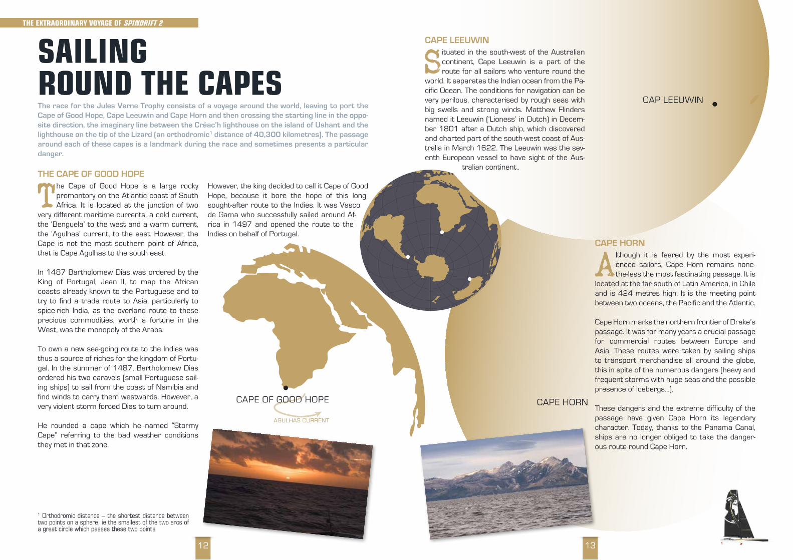
Situated in the south-west of the Australian continent, Cape Leeuwin is a part of the route for all sailors who venture round the
world. It separates the Indian ocean from the Pa-cific Ocean. The conditions for navigation can be very perilous, characterised by rough seas with big swells and strong winds. Matthew Flinders named it Leeuwin (‘Lioness’ in Dutch) in Decem-ber 1801 after a Dutch ship, which discovered and charted part of the south-west coast of Aus-tralia in March 1622. The Leeuwin was the sev-enth European vessel to have sight of the Aus-
tralian continent..
CAPE HORN
Although it is feared by the most experi-enced sailors, Cape Horn remains none-the-less the most fascinating passage. It is
located at the far south of Latin America, in Chile and is 424 metres high. It is the meeting point between two oceans, the Pacific and the Atlantic.
Cape Horn marks the northern frontier of Drake’s passage. It was for many years a crucial passage for commercial routes between Europe and Asia. These routes were taken by sailing ships to transport merchandise all around the globe, this in spite of the numerous dangers (heavy and frequent storms with huge seas and the possible presence of icebergs…).
These dangers and the extreme difficulty of the passage have given Cape Horn its legendary character. Today, thanks to the Panama Canal, ships are no longer obliged to take the danger-ous route round Cape Horn.
SaILING rOuND THE CaPESThe race for the Jules Verne Trophy consists of a voyage around the world, leaving to port the Cape of Good Hope, Cape Leeuwin and Cape Horn and then crossing the starting line in the oppo-site direction, the imaginary line between the Créac’h lighthouse on the island of Ushant and the lighthouse on the tip of the Lizard (an orthodromic1 distance of 40,300 kilometres). The passage around each of these capes is a landmark during the race and sometimes presents a particular danger.
THE CAPE OF GOOD HOPE
The Cape of Good Hope is a large rocky promontory on the Atlantic coast of South Africa. It is located at the junction of two
very different maritime currents, a cold current, the ‘Benguela’ to the west and a warm current, the ‘Agulhas’ current, to the east. However, the Cape is not the most southern point of Africa, that is Cape Agulhas to the south east.
In 1487 Bartholomew Dias was ordered by the King of Portugal, Jean II, to map the African coasts already known to the Portuguese and to try to find a trade route to Asia, particularly to spice-rich India, as the overland route to these precious commodities, worth a fortune in the West, was the monopoly of the Arabs.
To own a new sea-going route to the Indies was thus a source of riches for the kingdom of Portu-gal. In the summer of 1487, Bartholomew Dias ordered his two caravels [small Portuguese sail-ing ships] to sail from the coast of Namibia and find winds to carry them westwards. However, a very violent storm forced Dias to turn around.
He rounded a cape which he named “Stormy Cape” referring to the bad weather conditions they met in that zone.
However, the king decided to call it Cape of Good Hope, because it bore the hope of this long sought-after route to the Indies. It was Vasco de Gama who successfully sailed around Af-rica in 1497 and opened the route to the Indies on behalf of Portugal.
THE ExTraOrDINary VOyaGE OF SPINDrIFT 2
1 orthodromic distance – the shortest distance between two points on a sphere, ie the smallest of the two arcs of a great circle which passes these two points

1514
We have been sailing in the Southern Ocean
for a week without seeing an albatross.
During the last attempt at the record for
the Jules Verne Trophy Xavier (Revil)
and Thierry (Duprey du Vorsent)
each saw an albatross follow their yacht
for hours on end. Tom (Rouxel) explained that these birds play around
with speed and prefer to have fun with multi-hulls rather
than following behind slower vessels. My adventure on the
Southern Ocean has only just begun and I keep hoping
to see the ‘King of the Oceans’ in action.
And then, when I was just about to post this article, a young albatross did us the honour of visiting
us. First of all, it was timid, it gained in confidence and came very close to the boat, flying beside us,
as though we were its training partner. Time stopped for all the crew of Spindrift 2 who watched this
spectacle, less than two metres from the boat. What a privilege! So beautiful, so rare…
Extract from the ship’s log of DB during the 2015-2016 voyage.
Spindrift2
The VIeW OF DOn
a
Dona
It is the largest living bird. A wing span of be-tween 2.5 – 3.5 metres allows them to fly and glide in the sky for hours on end with-
out even having to beat their wings. Even in the middle of the worst storms at sea the albatross appears not to move.
The real conqueror of the raging seas of the South, its body is in harmony with the wind and, with outstretched wings, it is able to change di-rection when the wind blows, sometimes swoop-ing over the surface of the sea and sometimes up into the sky. It is this dynamic gliding that enables the albatross to glide on the wind for thousands of miles, rarely beating its wings. On average, a 50-year old albatross will have
flown 3.7 million miles during its lifetime. The albatross only goes ashore to reproduce, and spends two years courting its soul-mate, which becomes the one love of its life. Their single off-spring, needs both its parents to provide enough nourishment for it, and that’s a real challenge!
They both must fly more than 10,000 miles to gather enough fish and squid to give their grow-ing little one food. By the time the young albatross leaves its nest at 9 months old, it flies off alone at sea where it will survive for five years before returning to the exact spot where it was born in order to find, in turn, its soul mate and thus con-tinue the cycle of life..
THE aLBaTrOSS, KING OF THE OCEaNS
2015/12/11
THE aNImaLS ENCOuNTErEDDuring the attempt at a round the world record under sail, most of the sailors are completely ab-sorbed in the race. However, some have had surprises, even unexpected companions on their voyage.
When Olivier de Kersauson and his crew tried
to win the Jules Verne Trophy in January 2003, they encoun-tered a giant squid off Madeira. The animal had slowed down their trimaran Geronimo, and it had tentacles as big as human arms.Giant squid Archi-teuthid (Latin name) are present through-out most of the world. They live at depths be-tween 300 and 1,000 metres, even though sometimes they come up to the surface. It was only in July 2012 that the species was first prop-erly observed and filmed living in its natural habi-tat off Japan.During Spindrift racing’s last attempt around the
world, the sailors weren’t isolated in the middle of the oceans. At each stage of their voyage they had visits from several marine animals, which accompanied them: from majestic albatrosses to impressive flying fish and playful dolphins as well as imposing whales, the oceans yielded their treasures!
THE ExTraOrDINary VOyaGE OF SPINDrIFT 2

1716
THE ROARING FORTIES AND THE FURIOUS FIFTIES Entry into the Southern Oceans does not pass unnoticed. Depression after depression, the strongest winds upon the earth are unleashed and an unbelievable force on the water causes waves up to 15 metres in height! The Forties and Fifties are feared by sailors who find themselves very far from land in this region of the globe.
THE UFOsOften impossible to detect on the radar, other uncontrollable elements are added to the weath-er risks. Here we are talking about UFOs (Uni-dentified Floating Objects) such as, for example, whales, containers or wooden debris.
Maritime experts estimate that of the 200 mil-lion containers transported across the oceans of the world, about 10,000 fall into the sea each year. Each of these “boxes” can measure up to 40 feet (about 12 metres) and represent an eco-logical risk.
When containers falling overboard are reported, the forecasters and CEDRE (Centre for research on accidental water pollution [a French organiza-tion]) will establish the area at risk taking into con-sideration drifting caused by wind and currents.
The [French] Navy and Customs will carry out patrols to try and find them. For its part CROSS (The Regional Operational and Rescue Centre) will warn vessels crossing this sector.
However, this method remains random in as much as losses of containers are not always notified by the ship owners. The only method for avoiding these UFOs is to keep a permanent watch on the surface of the sea.
Luckily, the further South you go, the rarer these containers and large pieces of rubbish become.
THE ExTraOrDINary VOyaGE OF SPINDrIFT 2
OBSTaCLES TO OVErCOmE!Racing yachts today are at the forefront of technology, with ever-improving performance. They can, however, all suffer from major damage. Natural phenomena such as weather, icebergs or human factors can also represent dangers, even for a seasoned crew
THE DOLDRUMS
What’s known as the Doldrums is a meteor-ological zone where the North East winds of the Northern hemisphere and the
South East winds of the Southern hemisphere converge off Sierra Leone (Africa) to produce a cone-shaped transition zone pointing towards South America rather like a belt around the globe at the level of the equator.The winds are light and stormy squalls are numer-ous because of the high rate of evaporation just above the equator. The Doldrums can generally be found between the latitude 3° and 7° North
and are more or less constantly active with weak winds alternating with violent gusts and squalls, a widespread area of calm and a slow transition between the two sets of trade winds in the North-ern and Southern hemispheres.Thanks to a great amount of weather data and satellite images analysed by Jean-Yves Bernot, Spindrift 2’s navigator ashore, Erwan the on-board navigator and Yann Guichard can find the best point to cross this zone and thread their way southwards.
Wretched Doldrums!
These last few hours onboard are only for him ...Erwan, our
navigator, tells us that during one of his trips for the Volvo
Ocean Race at the approach to the Doldrums he was
sailing at 30 knots speed when all of a sudden, nothing.
Nothing, not a breath of air!So here we are, on Spindrift 2 watching out for every
cloud, every breath of a breeze, each colour change on the sea or frequency of the
waves.
For the moment, it’s not too bad. We are more or less managing to advance and we haven’t yet had a stop.
The hardest thing has been the sail changes, repetitively reefing in [the sails] when the wind changes from 5
to 25 knots. The key word for the watch leaders: don’t let yourselves be surprised and anticipate well ahead.
Two petrels came and said hello this morning. These birds, white below and black backed, live at sea. They
only return ashore to lay a single egg. They have followed us for a short while and then they disappeared
over the horizon into a grey sky full of rain. So, when are we going to get a drenching?
Dona Bertarelli
Spindrift2
The VIeW OF DOn
a
Dona
2015/11/261:30 AM CUT
1918
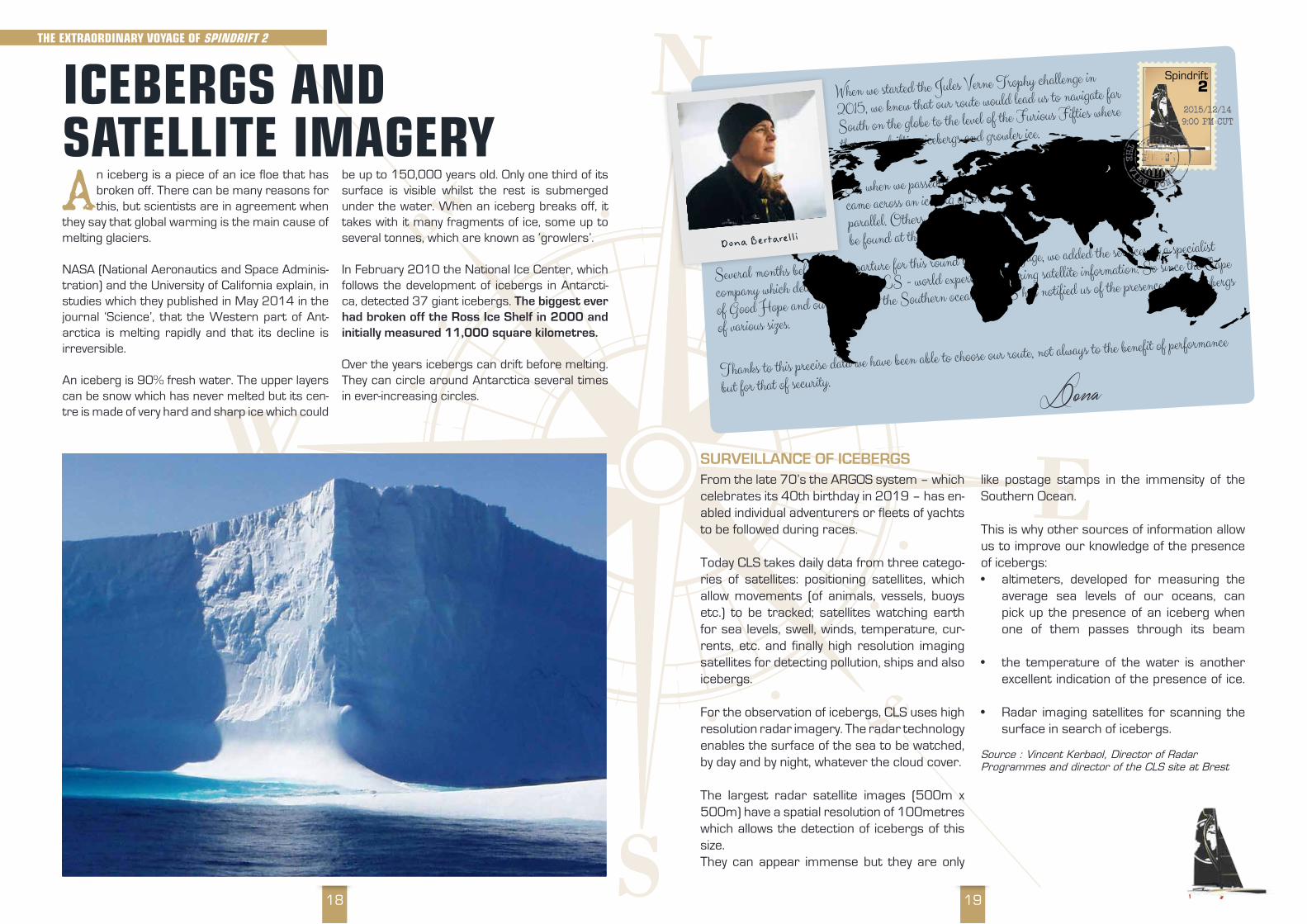
SURVEILLANCE OF ICEBERGSFrom the late 70’s the ARGOS system – which celebrates its 40th birthday in 2019 – has en-abled individual adventurers or fleets of yachts to be followed during races.
Today CLS takes daily data from three catego-ries of satellites: positioning satellites, which allow movements (of animals, vessels, buoys etc.) to be tracked; satellites watching earth for sea levels, swell, winds, temperature, cur-rents, etc. and finally high resolution imaging satellites for detecting pollution, ships and also icebergs.
For the observation of icebergs, CLS uses high resolution radar imagery. The radar technology enables the surface of the sea to be watched, by day and by night, whatever the cloud cover.
The largest radar satellite images (500m x 500m) have a spatial resolution of 100metres which allows the detection of icebergs of this size. They can appear immense but they are only
like postage stamps in the immensity of the Southern Ocean.
This is why other sources of information allow us to improve our knowledge of the presence of icebergs:• altimeters, developed for measuring the
average sea levels of our oceans, can pick up the presence of an iceberg when one of them passes through its beam
• the temperature of the water is another excellent indication of the presence of ice.
• Radar imaging satellites for scanning the surface in search of icebergs.
Source : Vincent Kerbaol, Director of Radar Programmes and director of the CLS site at Brest
When we started the Jules Verne Trophy challenge in
2015, we knew that our route would lead us to navigate far
South on the globe to the level of the Furious Fifties where
there are drifting icebergs and growler ice.
So, when we passed through the Indian ocean, we
came across an iceberg of 2km surface area at the 47th
parallel. Others, smaller in size, 100m x 400 m were to
be found at the 51st parallel.
Several months before our departure for this round the world voyage, we added the services of a specialist
company which detects icebergs, CLS - world experts in gathering satellite information. So since the Cape
of Good Hope and our entry into the Southern oceans, CLS has notified us of the presence of 34 icebergs
of various sizes.
Thanks to this precise data we have been able to choose our route, not always to the benefit of performance
but for that of security.
Dona Bertarelli
Spindrift2
The VIeW DOna
Dona
2015/12/149:00 PM CUT
ICEBErGS aND SaTELLITE ImaGEryAn iceberg is a piece of an ice floe that has
broken off. There can be many reasons for this, but scientists are in agreement when
they say that global warming is the main cause of melting glaciers.
NASA (National Aeronautics and Space Adminis-tration) and the University of California explain, in studies which they published in May 2014 in the journal ‘Science’, that the Western part of Ant-arctica is melting rapidly and that its decline is irreversible.
An iceberg is 90% fresh water. The upper layers can be snow which has never melted but its cen-tre is made of very hard and sharp ice which could
be up to 150,000 years old. Only one third of its surface is visible whilst the rest is submerged under the water. When an iceberg breaks off, it takes with it many fragments of ice, some up to several tonnes, which are known as ‘growlers’.
In February 2010 the National Ice Center, which follows the development of icebergs in Antarcti-ca, detected 37 giant icebergs. The biggest ever had broken off the Ross Ice Shelf in 2000 and initially measured 11,000 square kilometres.
Over the years icebergs can drift before melting. They can circle around Antarctica several times in ever-increasing circles.
THE ExTraOrDINary VOyaGE OF SPINDrIFT 2

2120
RECYCLING OF CARBON DIOXIDEOne third of the carbon dioxide emitted by human activities is absorbed by the oceans. Its role as ‘moderator’ in global warming of the planet has however, very serious consequences for the ocean because the carbon dioxide dissolved in them affects marine ecosystems and thus the biodiversity.
Equally, the oceans represent a great source for raw materials, such as nickel and oil. It is also a vital source of nourishment for numerous living things. Marine products represent 10 – 20% of all the animal proteins consumed in the world.
To learn more, download the Spindrift for Schools lesson: Mers et Oceans.Only available in French at http://spindriftforschools.com
ZOOPLANKTONIt is made up of animal organisms which drift with the currents. In or-der to live, zooplankton needs to eat either phytoplankton or zooplankton smaller than itself. It is the first link in the food chain of marine animals.
The oceans of the planet are the origin of more than half the world-wide production of organic material, thanks to the activities of photosyn-thesis by marine phytoplankton.
These micro-organisms in suspen-sion in the sea play a part in the car-bon cycle in producing matter, thanks to carbon dioxide and sunlight.
If plankton constitute 98% of the bio-mass in the sea, it absorbs more than half the carbon dioxide and produces 50% of the oxygen.
It is easy to see how important it is to preserve the oceans in order to main-tain a balanced climate on the planet.
ATLANTICOCEAN
PACIFIC OCEAN
WARM CURRENT ON THE SURFACE
COLD AND SALTY WATER AT DEPTH
INDIAN OCEAN
PACIFIC OCEAN
THE COLDEST AND SALTIEST WATER IS AT THE BOTTOM OF THE NORTH ATLANTIC AND IS THE MOTOR THAT DRIVES THIS CIRCULATION.
thermohaline circulation
THE INFLuENCE OF OCEaNS ON CLImaTEAn important source of food and raw materials, oceans are also the basis for thermal exchanges, which regulate the world’s climate.
The ocean is a reservoir of heat for the plan-et. 30% of energy stored is returned to the atmosphere by evaporation in the form of
‘latent heat’. When the water changes state and the water vapour condenses, the ‘latent heat of evaporation’ forms clouds. In tropical regions,
the oceans hold a huge amount of heat. Currents transport it to other regions in the world where they moderate [the temperature]. Oceans have an essential role in the regulation of the air tem-perature around the globe.
THE ExTraOrDINary VOyaGE OF SPINDrIFT 2
OCEANIC CURRENTSThey are caused by the sun’s rays which heat the planet differently be-tween the equator and the poles.The Gulf Stream is a warm current born in the Tropics but there are oth-er currents, coming from the polar regions, which are cold. The masses of air turn like the hands of a clock in the Northern hemisphere and coun-ter-clockwise in the Southern hemi-sphere
thus the warm currents take warmth to the poles and the cold currents cool the waters of the tropics.
Deeper down, the currents are slow-er and they are caused by the dif-ferences in densities between the masses of water in the oceans. The coldest and saltiest waters drop to the bottom whilst warmer and fresh-er waters are lighter and rise to the surface. This phenomenon is known as “Thermohaline Circulation”
2322
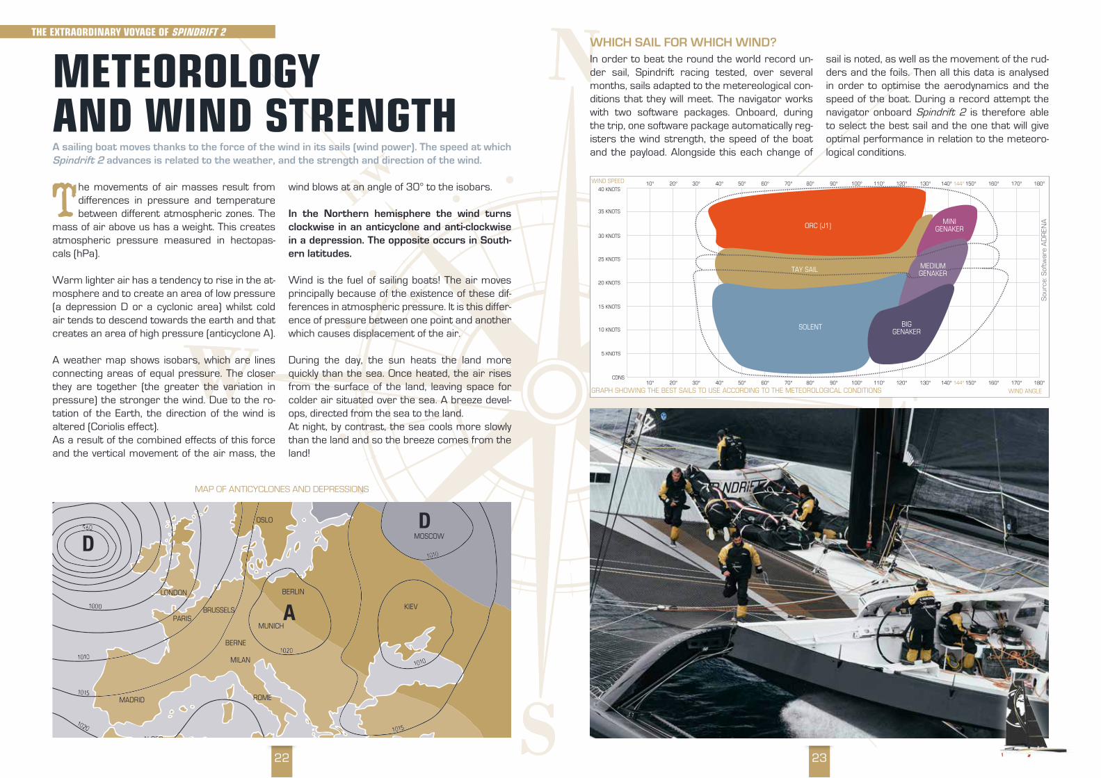
WHICH SAIL FOR WHICH WIND?In order to beat the round the world record un-der sail, Spindrift racing tested, over several months, sails adapted to the metereological con-ditions that they will meet. The navigator works with two software packages. Onboard, during the trip, one software package automatically reg-isters the wind strength, the speed of the boat and the payload. Alongside this each change of
sail is noted, as well as the movement of the rud-ders and the foils. Then all this data is analysed in order to optimise the aerodynamics and the speed of the boat. During a record attempt the navigator onboard Spindrift 2 is therefore able to select the best sail and the one that will give optimal performance in relation to the meteoro-logical conditions.
40 KNOTS
WIND ANGLE
WIND SPEED 10° 20° 30° 40° 50° 60° 70° 80° 90° 100° 110° 120° 130° 140° 150° 160° 170° 180°144°
10° 20° 30° 40° 50° 60° 70° 80° 90° 100° 110° 120° 130° 140° 150° 160° 170° 180°144°
35 KNOTS
30 KNOTS
25 KNOTS
20 KNOTS
15 KNOTS
10 KNOTS
5 KNOTS
CDNS
ORC (J1)
TAY SAIL
SOLENT
MINIGENAKER
MEDIUMGENAKER
BIGGENAKER
GraPh ShoWinG the BeSt SailS to uSe accordinG to the meteoroloGical conditionS
Sou
rce:
Sof
twar
e A
DR
ENA
mETEOrOLOGy aND WIND STrENGTHA sailing boat moves thanks to the force of the wind in its sails (wind power). The speed at which Spindrift 2 advances is related to the weather, and the strength and direction of the wind.
The movements of air masses result from differences in pressure and temperature between different atmospheric zones. The
mass of air above us has a weight. This creates atmospheric pressure measured in hectopas-cals (hPa).
Warm lighter air has a tendency to rise in the at-mosphere and to create an area of low pressure (a depression D or a cyclonic area) whilst cold air tends to descend towards the earth and that creates an area of high pressure (anticyclone A).
A weather map shows isobars, which are lines connecting areas of equal pressure. The closer they are together (the greater the variation in pressure) the stronger the wind. Due to the ro-tation of the Earth, the direction of the wind is altered (Coriolis effect).As a result of the combined effects of this force and the vertical movement of the air mass, the
wind blows at an angle of 30° to the isobars.
In the Northern hemisphere the wind turns clockwise in an anticyclone and anti-clockwise in a depression. The opposite occurs in South-ern latitudes.
Wind is the fuel of sailing boats! The air moves principally because of the existence of these dif-ferences in atmospheric pressure. It is this differ-ence of pressure between one point and another which causes displacement of the air.
During the day, the sun heats the land more quickly than the sea. Once heated, the air rises from the surface of the land, leaving space for colder air situated over the sea. A breeze devel-ops, directed from the sea to the land. At night, by contrast, the sea cools more slowly than the land and so the breeze comes from the land!
ANTARCTIQUE
OSLO
BERLIN
BERNE
BRUSSELS
MADRID
ALGER
MILAN
PARIS
LONDON
ROME
KIEV
MOSCOW
MUNICHA
A
DD
MAP OF ANTICYCLONES AND DEPRESSIONS
THE ExTraOrDINary VOyaGE OF SPINDrIFT 2
2524
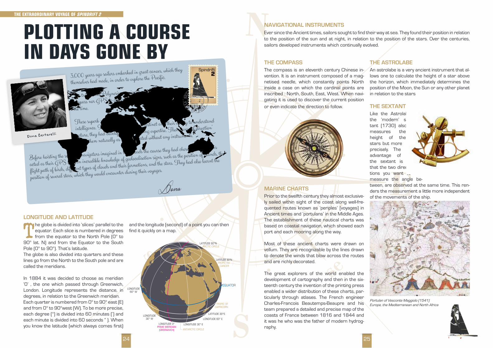
THE COMPASS The compass is an eleventh century Chinese in-vention. It is an instrument composed of a mag-netised needle, which constantly points North inside a case on which the cardinal points are inscribed : North, South, East, West. When navi-gating it is used to discover the current position
or even indicate the direction to follow.
MARINE CHARTSPrior to the twelfth century they almost exclusive-ly sailed within sight of the coast along well-fre-quented routes known as ‘periples’ [voyages] in Ancient times and ‘portulans’ in the Middle Ages. The establishment of these nautical charts was based on coastal navigation, which showed each port and each mooring along the way.
Most of these ancient charts were drawn on vellum. They are recognizable by the lines drawn to denote the winds that blow across the routes and are richly decorated.
The great explorers of the world enabled the development of cartography and then in the six-teenth century the invention of the printing press enabled a wider distribution of these charts, par-ticularly through atlases. The French engineer Charles-Francois Beautemps-Beaupre and his team prepared a detailed and precise map of the coasts of France between 1816 and 1844 and it was he who was the father of modern hydrog-raphy.
THE ASTROLABEAn astrolabe is a very ancient instrument that al-lows one to calculate the height of a star above the horizon, which immediately determines the position of the Moon, the Sun or any other planet in relation to the stars
THE SEXTANT Like the Astrolabe, the ‘modern’ sex-tant (1730) also measures the height of the stars but more precisely. The advantage of the sextant is that the two direc-tions you want to measure the angle be-tween, are observed at the same time. This ren-ders the measurement a little more independent of the movements of the ship.
NAVIGATIONAL INSTRUMENTSEver since the Ancient times, sailors sought to find their way at sea. They found their position in relation to the position of the sun and at night, in relation to the position of the stars. Over the centuries, sailors developed instruments which continually evolved.
Portulan of Vesconte Maggiolo (1541) Europe, the Mediterranean and North Africa
LONGITUDE AND LATITUDE
The globe is divided into ‘slices’ parallel to the equator. Each slice is numbered in degrees from the equator to the North Pole (0° to
90° lat. N) and from the Equator to the South Pole (0° to 90°). That’s latitude.The globe is also divided into quarters and these lines go from the North to the South pole and are called the meridians.
In 1884 it was decided to choose as meridian ‘0’ , the one which passed through Greenwich, London. Longitude represents the distance, in degrees, in relation to the Greenwich meridian.Each quarter is numbered from 0° to 90° east (E) and from 0° to 90°west (W). To be more precise, each degree (°) is divided into 60 minutes (‘) and each minute is divided into 60 seconds “ ). When you know the latitude (which always comes first)
and the longitude (second) of a point you can then find it quickly on a map.
PLOTTING a COurSE IN DayS GONE By
LONGITUDE60° W
LONGITUDE30° W
LONGITUDE 30° E
LONGITUDE 60° E
LATITUDE 30°S
LATITUDE 30°N TROPIC DU CANCER
LATITUDE 60°N ARCTIC CIRCLE
EQUATOR
LONGITUDE 0°PRIME MERIDIAN
(GREENWICH)
TROPIC OF CAPRICORN
ANTARCTIC CIRCLE
THE ExTraOrDINary VOyaGE OF SPINDrIFT 2
3,000 years ago sailors embarked in great canoes, which they
themselves had made, in order to explore the Pacific.
The traditional Polynesian navigators had neither radio nor
compass nor GPS to guide them, check their speed or tell
the time.
These superb navigators had as their only instrument their
intelligence. In effect, thanks to their instinct and their ability to understand
nature, they had developed their seagoing expertise. Their ‘sense of direction’
served them naturally as they navigated without any instruments.
Before hoisting the sails, the navigators imagined in their heads the course they had chosen. Their brains
acted as their GPS with an incredible knowledge of geolocalisation signs, such as the position of islands, the
flight path of birds, different types of clouds and their formations, and the stars. They had also learnt the
position of several stars, which they would encounter during their voyages.
Dona Bertarelli
Spindrift2
The VIeW OF DOn
a
Dona
2726
GPSThe Global Positioning System determines, to within several metres, the position of the boat, thanks to several satellites positioned at an alti-tude of 25,000 km. These satellites emit radio signals and the principle rests on measuring
the time from when the radio wave is emitted in space by the satellite and received the receiver - the boat. When the boat moves away from the satellite, the wave-length of the signal increases. If it comes closer, it decreases.
ONBOARD ENERGYIn order to supply energy for all the electronic items used in navigation, the maxi-trimaran is equipped with six batteries. To recharge these, the boat has photovoltaic panels, which cover five square metres of the surface of the cockpit coachroof. They are made up of numerous cells,
which contain miniscule grains of silica. The sun’s rays penetrate the cells and agitate the grains, which creates electricity. Spindrift 2 is moving towards self-sufficiency in energy and over time aims to be able to provide its total requirement for energy using green energies.
PLOTTING a COurSE TODayThese days developments in research and innovation have greatly facilitated the ability of sailors to find their bearings at sea, particularly thanks to the invention of measuring instruments and electronic positional systems. At sea, the sailors on Spindrift 2 have to be able to analyse the weather and to thus choose the best route. A router based onshore and the technical instru-ments onboard the boat, allow them to choose the best possible strategy and route.
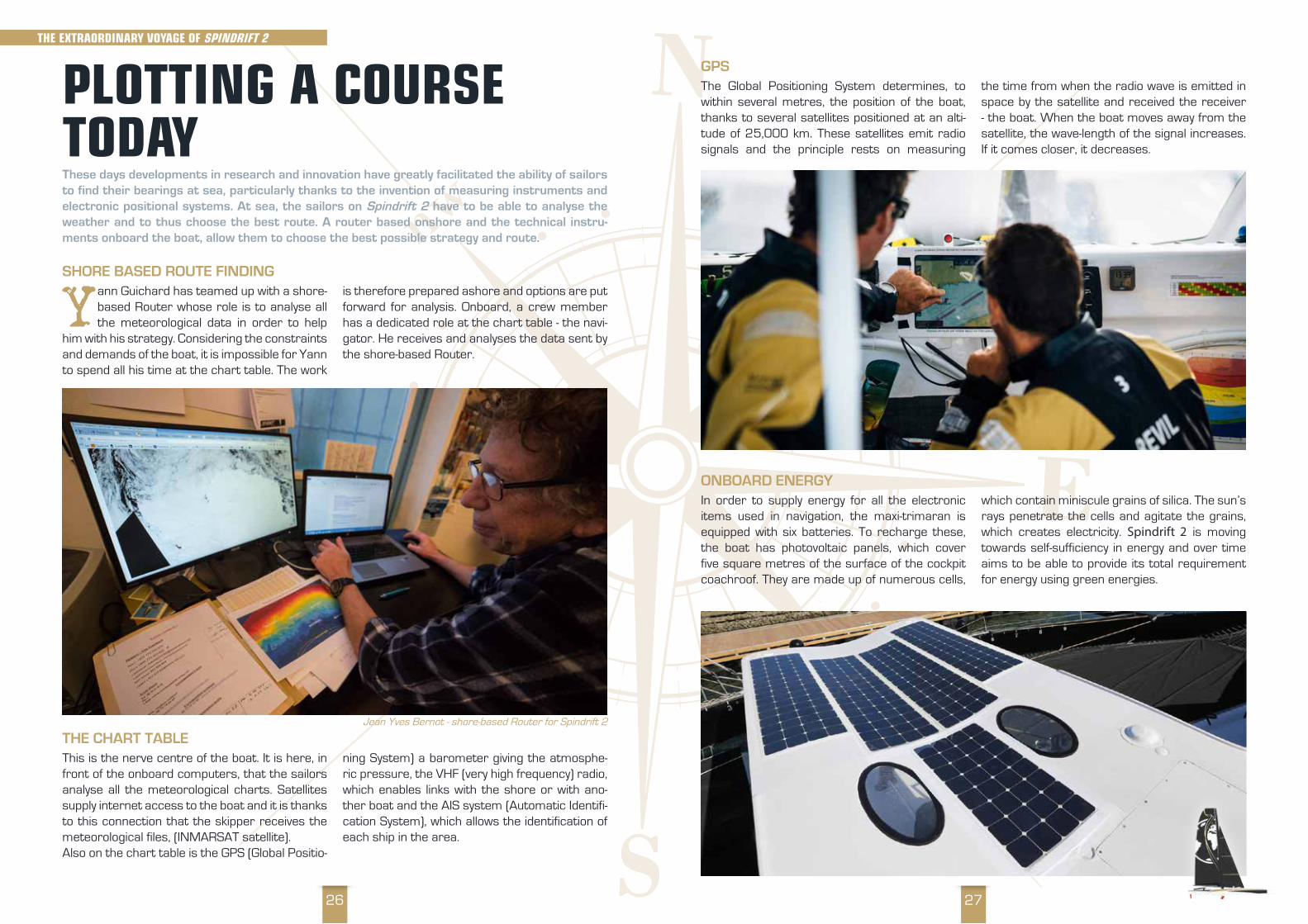
SHORE BASED ROUTE FINDING
Yann Guichard has teamed up with a shore-based Router whose role is to analyse all the meteorological data in order to help
him with his strategy. Considering the constraints and demands of the boat, it is impossible for Yann to spend all his time at the chart table. The work
is therefore prepared ashore and options are put forward for analysis. Onboard, a crew member has a dedicated role at the chart table - the navi-gator. He receives and analyses the data sent by the shore-based Router.
THE CHART TABLE This is the nerve centre of the boat. It is here, in front of the onboard computers, that the sailors analyse all the meteorological charts. Satellites supply internet access to the boat and it is thanks to this connection that the skipper receives the meteorological files, (INMARSAT satellite).Also on the chart table is the GPS (Global Positio-
ning System) a barometer giving the atmosphe-ric pressure, the VHF (very high frequency) radio, which enables links with the shore or with ano-ther boat and the AIS system (Automatic Identifi-cation System), which allows the identification of each ship in the area.
Jean Yves Bernot - shore-based Router for Spindrift 2
THE ExTraOrDINary VOyaGE OF SPINDrIFT 2
2928
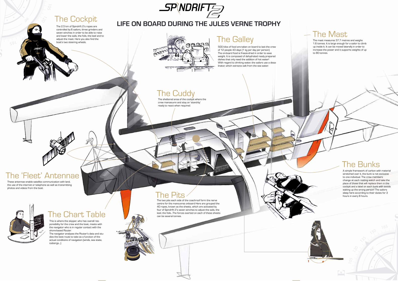
LIFE ON BOARD DURING THE JULES VERNE TROPHYThe Cockpit
The Galley
The Cuddy
The Mast
The ‘Fleet’ Antennae
The Pits
The Bunks
The Chart Table
The 2.5 km of Spindrift 2’s ropes are controlled by 6 sailors, three grinders and seven winches in order to be able to raise and lower the sails, the foils, the keel and to adjust the mast. Here you also find the boat’s two steering wheels.
500 kilos of food are taken on board to last the crew of 12 people 43 days (1 kg per day per person)The on-board food is freeze-dried in order to save weight. It is composed of dehydrated ready prepared dishes that only need the addition of hot water! With regard to drinking water, the sailors use a desa-linator, which extracts salt from the sea water.
The mast measures 37.7 metres and weighs 1.6 tonnes. It is large enough for a sailor to climb up inside it. It can be moved laterally in order to increase the power and it supports weights of up to 80 tonnes.
A simple framework of carbon with material stretched over it, the bunk is not exclusive to one individual. The crew members change at each resting watch and take the place of those that will replace them in the cockpit and a label on each bunk with avoids waking up the wrong person! The sailors sleep here according to their duties for 3 hours in every 8 hours.
The two pits each side of the coachroof form the nerve centre for the manouvres onboard Here are grouped the 40 ropes, known as the sheets, which are activated by four of Spindrift 2’s seven winches to adjust the sails, the keel, the foils…The forces exerted on each of these sheets can be several tonnes.
The sheltered area of the cockpit where the crew manoeuvre and stay on ‘stand-by’ ready to react when required.
These antennae enable satellite communication with land, the use of the internet or telephone as well as transmitting photos and videos from the boat.
This is where the skipper, who has overall res-ponsibility for the crew and the boat, meets with the navigator who is in regular contact with the shore-based Router.The navigator analyses the Router’s data and stu-dies the best route to take as a function of the actual conditions of navigation (winds, sea state, icebergs…)

3130
The aerodynamics have been improved thanks to an elongated coachroof and the replacement of some lines by tar-
paulin fairings to improve performance. After the experience of the previous round the world voyage, the team’s design office has worked on improvements to performance for this attempt. In total, a team of twenty techni-cians have made the necessary checks and car-ried out modifications, particularly to the interior and exterior layouts.
The team has also developed a foil with new tips (a new fin on the lower part of the foil), which now points upwards and allows the bow to be lifted. The foils put additional vertical pressure on the bow, so the team worked on new T-shaped rud-der blades. The combined action of the foil and
the rudder blades improves the vertical pressure on the hull, and therefore helps to reduce drag on the boat.
With a view to protecting the environment, Spindrift racing also focuses on becoming as self-sufficient as possible in terms of energy. To this end engineers have looked at exploiting the available surfaces exposed to the sun on the coachroof of the boat and installed five square metres of solar panels, that are able to recharge the batteries that run the electronic equipment onboard Spindrift 2.
For 2019 – 2020 the aim is to beat the Jules Verne Trophy record established in January 2017 of 40 days, 23 hours, 30 minutes and 30 seconds.
WHAT IS A MAXI-TRIMARAN?A trimaran is a multi hull vessel (as opposed to a mono-hull, with only one hull.) The main aim of multi-hulls is to increase the power of the boat thanks to its width and the sail surface.These two parameters translate into an increase in top speed. Taking account of its larger
than normal size, Spindrift 2 is considered to be a maxi-trimaran.
40 metres long, 23 metres beam, 37.7 metre-high mast: Spindrift 2 is the largest racing trimaran in the world.
Spindrift 2 , formerly Banque Populaire V, is a holder of ocean-going records including the Jules Verne Trophy in 2012. Loic Peyron
was at the helm and, with his crew, they encircled the globe in 45 days.
Yann Guichard and Dona Bertarelli with their 12 crew tried to improve on this record time during their first attempt around the world in winter 2015-2016. The unfavourable weather at the end of the race prevented them from fulfilling this objective but even so they notched up the third best time in history with 47 days 10 hours 59 minutes and 02 seconds of navigation.
Changed since the 2015-2016 attempt, was to re-fit its original mast, which had been shortened and adapted in 2014 for the ‘Route du Rhum’ race. The boat is therefore 500 kgs lighter and the improved structure of the new shorter mast makes it 25% lighter than the original.
This new carbon spar has meant that the maxi-trimaran lost some sail area but it has gained manoeuverability. This smaller mast has also involved some changes for the crew and for the riggers have had to adapt to the deck layout of Spindrift 2.
SPINDrIFT 2 BrED FOr rECOrDS
THE SPINDrIFT raCING TEam
REMEMBER!Multihulls are much faster than monohulls; they are also know as the ‘Formula 1 of the seas’ and can reach speeds of more than 30 knots (55 km/hour).SPINDRIFT 2’S TIMINGS IN 2014-2016Yann Guichard Spindrift 2 - Round the world - 47 days 10 hours 59 mins 02 secsDona Bertarelli: second fastest female navigator around the worldTime Ushant to Tasmania: 20 days 4 hours 37 minsTime Ushant to Cape Horn: 30 days 4 hours 07 mins. SPINDRIFT 2’S TIMING IN 2018-2019 Time Ushant to Equator : 4 days 20 hours 7 mins
3332
THE CrEW: ONBOarD aND ONSHOrE
There are 12 sailors to manoeuvre the largest trimaran in the world. For effi-ciency, each has a
pre-arranged role and sometimes an additional
responsibility onboard, whether technical or medical.
For its part, the shore-based team makes all the necessary arrangements beforehand and during the race so that the boat and the crew can work at their maximum capacity.
THE SPINDrIFT raCING TEam
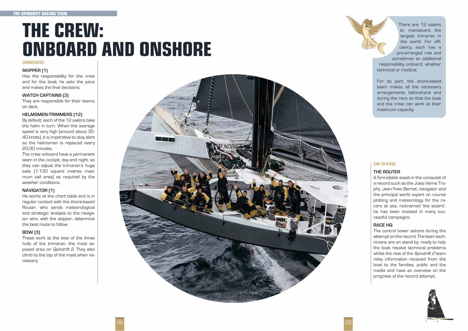
ONBOARD
SKIPPER (1)Has the responsibility for the crew and for the boat; he sets the pace and makes the final decisions.
WATCH CAPTAINS (3)They are responsible for their teams on deck.
HELMSMEN-TRIMMERS (12)By default, each of the 12 sailors take the helm in turn. When the average speed is very high (around about 35-40 knots), it is imperative to stay alert so the helmsmen is replaced every 20-30 minutes.The crew onboard have a permanent team in the cockpit, day and night, so they can adjust the trimaran’s huge sails (1,130 square metres maxi-mum sail area) as required by the weather conditions.
NAVIGATOR (1)He works at the chart table and is in regular contact with the shore-based Router, who sends meteorological and strategic analysis to the naviga-tor who, with the skipper, determine the best route to follow.
BOW (3) These work at the bow of the three hulls of the trimaran, the most ex-posed area on Spindrift 2. They also climb to the top of the mast when ne-cessary.
ON SHORE
THE ROUTERA formidable asset in the conquest of a record such as the Jules Verne Tro-phy. Jean-Yves Bernot, navigator and the principal world expert on course plotting and meteorology for the ra-cers at sea, nicknamed ‘the wizard’, he has been involved in many suc-cessful campaigns.
RACE HQThe control tower ashore during the attempt on the record. The team tech-nicians are on stand by, ready to help the boat resolve technical problems whilst the rest of the Spindrift 2 team relay information received from the boat to the families, public and the media and have an overview on the progress of the record attempt.

3534
Several women have attempted the Jules Verne Trophy but, to date, none have succeeded in carrying off the trophy.
DONA BERTARELLISailing has always played a part in the world of this businesswoman, philan-thropist and sailor. Competitive racing became a reality at the end of 2006 when she formed a female crew on the catamaran circuit on Lake Geneva. In 2010, at the helm of Ladycat , she became the first female sailor to win the prestigious ‘Bol d’Or Mirabaud’ and the following year she created Spin-drift racing with Yann Guichard, a racing team dedicated to nurture their nautical ambitions. Involved in a number of foundations, one of which is ded-icated to the conservation of the marine environment, in 2013 Dona Ber-tarelli discovered offshore multihull sailing onboard Spindrift 2. This female
sailor became the fastest woman around the world during the Jules Verne Trophy 2015–2016. This year she will be involved at the heart of the operational team ashore.
TRACY EDWARDSIn 1989 at the age of 23, Tracy Edwards led the first all-female team in the ‘Whitbread Round the World Yacht Race’. She became internation-ally recognised finishing second in the general classification of her category.Tracy Edward then took part in the Jules Verne Trophy aboard Royal Sun Alliance, still with an all-female crew. However, dismasted off Chile but she and her crew somehow managed to save the boat and bring it into port.
ELLEN MACARTHUREllen MacArthur is a Brit-ish sailor who became well known when she fin-ished second in the 2000 – 2001 Vendee Globe. In 2005 she beat record to sail solo round the world in ‘Solitaire’, with a time of 71 days 14 hours 18 minutes and 33 seconds. That same year she was honoured by Queen Elizabeth II. Very aware of ecological problems, in 2010 she created the Ellen MacArthur Foundation with the aim of get-ting the public and companies to re-think, develop and build a self-sufficient future by utilising the concept of a circular economy.
Here we must mention Florence Arthaud, who died tragically on 9 March 2015. Even though she did not sail in this round the world challenge, she was a co-founder of the Jules Verne Trophy.
‘It is nothing trivial to travel so far and for so long, to concentrate on one goal and to recreate a world with 14 people over 40 days, reflecting that the occupants of the international space station were our closest neighbours when we were in the middle of the Pacific. To be a team, you have to able to depend on one another, help each other, accept that there will be highs and lows, and find a balance to be able to succeed together.’D.B.
yaNN GuICHarD
WOmEN aND THE JuLES VErNE TrOPHy
YANN GUICHARD, SKIPPERBorn 23 May 1974 in Paris Second attempt at the Jules Verne Trophy
Originally from Ile aux Moines in Brittany, Yann Guichard is one of the most talented sailors of his generation. He has an impressive
sailing record and in particular with multihulls.
From the demanding high level of Olympic sailing, synonymous with discipline, rigour and organisa-tion, he has succeeded in realising his aspirations through work and perseverance. His passion for multihulls has led him to lead several major pro-jects.
Talented and multi-skilled, he has accumulated performances and victories on several circuits, as much in ocean racing as in inshore regattas (Route du Rhum, Transat Quebec Saint Malo, Transat Jacques Vabre, Extreme Sailing Series, America’s Cup World Series, World Match Rac-ing Tour, D35 Trophy…)
Yann is also a leader, who knows how to surround himself with a team ready to take on new chal-lenges. The Spindrift racing team, which he cre-ated with his partner Dona Bertarelli, and record campaigns with the maxi-trimaran Spindrift 2 in particular, are his passion. A devotee of meteor-ology and its sometimes complex phenomena, he remains very involved in the navigaton and the strategy of the route whether offshore or in-shore.
In the winter of 2015-2016 that Yann Guichard and his team completed their first attempt at the Jules Verne Trophy with the third best time in its history in 47 days 10 hours 59 minutes and 02 seconds and set a new record Ushant to Equa-tor in 4 days 20 hours and 7 minutes during the 2018-2019 attempt.
REMEMBER!Equality of the sexes: 200 years ago women had no right to board a boat! It was thought that, like rabbits, their presence onboard brought bad luck to the ships and their crews. Towards the end of the 1980’s there was a marked greater equality in the sport and women started to beco-me an integral part of ocean racing, with the likes of Florence Arthaud, Isabelle Autissier, Ellen MacArthur, Tracy Edwards, Sam Davies, and Dona Bertarelli…
THE SPINDrIFT raCING TEam

3736
Being responsible and having good sea-manship are two essential qualities whether it be sailing offshore or inshore.
Each member of the crew must be aware of the dangers in order to anticipate them to the best of their abilities and thus reduce risk.
Safety is the paramount responsibility of the skip-per. Whether on land or at sea, he has to give clear instructions on a daily basis and make sure that everyone respects these rules. During the round the world race, there are regular checks to ensure best maritime practice.
Onboard, each sailor is equipped with a safety kit: a pouch containing an individual beacon, distress flares, a tube of fluorescein, a waterproof survival suit, an inflatable vest and a light.
To avoid a crew member falling overboard a safety line is installed the length of the trimaran, known as the ‘life-line’. It allows each sailor going
onto the foredeck of the boat to be clipped on to this line with the aid of a harness that they wear around their waist.
ONBOARD MEDIC When a sailor is hurt another crewmember onboard will treat them if the boat is too isolated out at sea. All members of the crew have prior training in first aid: applying a bandage, suturing a cut, trea-ting a tooth, calming a stomach ache…
The first aid pack contains the necessary first aid items: plas-ters, bandages and pain relief, antibiotics as well as equipment for treating a minor injury.
SaFETy ONBOarD
aTHLETES IN ExTrEmE CONDITIONS Referring to beating speed records, also means thinking about physical performance. To ensure that the maxi-trimaran Spindrift 2 achieves its full potential, demands that the crew has to be at the peak of physical fitness.
The sailors must be fit for hoisting the sails, moving around the boat, repairing da-mage, but importantly, able to maintain this
rhythm over several weeks, sometimes in extre-me conditions!
Sailors are high-level athletes, physically as well as psychologically. They are in training throughout the year, either by building core strength as well as other physical and sporting activities..
To keep going for the length of the challenge, they also need to eat correctly with a balanced diet that gives them the nutrients to be able to ma-nage the high output of energy required to ma-nouvre the boat and, at the same time help them to withstand the cold.
However, as this is a speed record, to be fast the boat must be as light as possible. All excess weight is removed. As a result, the type of food loaded onboard has been adapted and the por-tions are freeze-dried.
REMEMBER!The sailors who try to beat the record for the Jules Verne Trophy are high-level athletes who must eat and train in the best way to optimise performance of the boat whatever the meteorological conditions.
LIFE ONBOarD SPINDrIFT 2

3938
REMEMBER!Freeze dried food takes up less space on a boat,
it weighs less and takes less time to prepare. It is
easier to manage the waste. The desalinator is the only source of fresh drinking water and sailors drink 60 litres daily between them.
Freeze drying is a process that involves removing water from a foodstuff in order to conserve it better. Onboard, sailors eat this type of food mainly because of concerns about storage.
It’s not easy to cook on a maxi-trimaran crashing about in perpetual motion but eve-rything is organised by the shore team!
A mini-galley is fitted out in the interior of the boat in order to be able to boil water to make the freeze-dried food hot. The sailors have to be careful as freeze dried foods lack minerals when rehydrated with desalinated water.
Even though a sailor eats and lives in a damp en-vironment, the body will lose water when using energy; they must therefore drink enough to keep hydrated.
Each yacht is equipped with a desalinator so as not to weigh the boat down with bottled water
FrEEZE-DrIED FOOD
Food is as important to the success of the project as the technical preparation of the boat. The sailors must enjoy eating and mealtimes are moments of team building.. VICTUALLING/PACKAGING
In the days before the start of the ‘stand by’ period the team loads the victuals onboard. The food taken onboard is calculated for a
period of 40 days and the meals are packed in sacks, which correspond to a daily ration for the whole crew.Whilst the sailors can benefit from fresh produce for the first few weeks (fruit, bread…) two thirds of the food is freeze-dried. Freeze-dried food is preferred because it offers considerable advan-tages for offshore racing. It is light (half, or even one third, the weight), takes up little room, can keep for a long period and remains relatively easy to prepare. Five minutes is sufficient to boil some water and add it to a sachet.
It is equally very important that the food is ba-lanced and rich in calories as one person working on a boat consumes twice as many calories as a sedentary person. Freeze-dried food also meets these requirements.
NUTRITIONAL REQUIREMENTS AT SEAThe issue for the offshore sailor is to find a good nutritional balance to take account of the phases of exertion, alterness and management on the boat: a balanced cocktail of proteins, complex carbohydrates and essential fatty acids. If the carbohydrates favour sleep, a mix rich in protein improves vigilance – therefore food becomes a real fuel.
The daily nutritional requirements of a sedentary adult male are 2,200 – 2,700 calories; a sailor needs about 5,500 calories per day to meet the efforts and conditions of the race.
Nutritionists prepared menus, which meet the energy needs and are to the taste of the sailors and the geographical zone in which they sail. En-ergy requirements differ according to the zones crossed: in cold zones each sailor consumes 5,500 calories daily, in temperate zones 4,500 calories and in hot zones 3,500 calories.
So in the cold climate of the southern oceans, sailors eat one extra meal, morning and evening, made up of dried fruit, oily seeds and air-dried and pressed meat from Grisons [Switzerland].
ONBOarD mEaLS
LIFE ONBOarD SPINDrIFT 2

4140
THE SLEEP OF SEA BIRDS
The numerous migrating and sea birds such as the swift, the frigate bird or the alba-tross, sleep on the wing in relatively short
bursts. These birds eat in flight and can cover hundreds of kilometres without touching down. Swifts group together and sleep in a circle, and can glide during their sleep periods. As for Fri-
gate birds, flying up to 1,500 metres high, they use their huge wings to face the wind, immobile, their hearts slowing right down.
Recent research is still unable to give all the answers, however two theories exist: the first that these birds are be capable of putting to sleep their left and right cerebral hemispheres alternatively; so half the brain is awake, the other half asleep; the second theory is that they can alternate phases of sleep and waking very quickly.
Sleeping at Sea
We are now more than two weeks living with the watch
system, linked periods of three hours of sleep, five
hours of work, three hours of sleep and so on. Have
we followed special training to get to this?
No, in our case, you can’t train for it ashore.
The work onboard is so physically and mentally
demanding that the body, after several days at sea, rapidly gets used to
these conditions. But it is not a subject to be taken lightly and we remain
alert to each other’s state of tiredness. This can get complicated if the navigational conditions are
difficult and the watch system gets upset, as some manoeuvres take time and require the whole crew
to be on deck.
Some years ago sailors took part in a study of sleep. It proved that in the case of extreme fatigue,
only the body can recuperate given a short siesta. It needs a much longer period of sleep for the
brain to recover in its turn.
Sleep (as long as you are eating well and not sea sick, something that happens even to professional
sailors) is essential for finding a balance and to be able to sustain a rhythm, which must be
maintained over several weeks whilst remaining effective. However, it is true that tiredness builds
up and, once returned ashore, it sometimes can take days and even weeks for total recuperation.
Dona Bertarelli
Spindrift2
The VIeW OF DOn
a
Dona
2015/12/104:00 PM CUT
Sleep takes up more than one third of our life. It is necessary for growth, development of the brain and for our physical and mental recuperation. In order to beat the record for the Jules Verne Trophy, the team must ‘forget’ their habits and work to a system of watches.
Ashore, an adult’s sleep is divided into diffe-rent periods of around 90 minutes each. Sleep is made up of 75% deep sleep and
25% active sleep - Non-Rapid Eye Movement (NREM) and Rapid Eye Movement (REM)
At sea, the crew of Spindrift 2 cannot maintain a one-stage sleep, or one solid sleep through the night. For the boat’s performance, the crew works in relays on deck, day and night and has scheduled rest periods. This is known as the watch system.
• the sailors are ‘on watch’ for 3 hours and must be on deck for helming and manoeuvering
• then they are on ‘stand by’ for 45 minutes, dressed and ready for manoeuvres if required
• then they have 3 hours rest during which time they can sleep, change clothes and eat
• finally, for another period of 45 minutes they must be up and dressed and ready for ma-noeuvering if required
If all is going well then the rest period is devoted to sleeping, eating or relaxing. However, in case of manoeuvres or extreme weather conditions, the sailors are on “stand-by”, postponing the rest period until later and come and work on deck.The rhythm of the Jules Verne Trophy obliges the crew to limit periods of recuperation.
You have to imagine the three hours maximum of sleep on the ‘watches’ in basic bunks, listing at 30° or with the boat doing 30 knots hitting the waves so the carbon hull picks up and am-plifies the noise.
The sailors accustom themselves to polyphasic sleep during their months ashore so they are used to sleeping in short bursts.
If, when onboard, they don’t get enough sleep it affects their cognitive performance first. Their capacity for thought and analysis is much weaker as the brain performs less well.
SLEEPING ONBOarD
REMEMBER!On land under “normal” living conditions an adult sleeps between 7 and 9 hours a night in one go. This is called monophasic sleep. At sea, to be efficient and take over on deck, the sailors have polyphasic sleep with their days split into watches.
LIFE ONBOarD SPINDrIFT 2

4342
In terms of clothing, the complexity of a round the world trip means that the sailors travel from very hot climates at the equator to very cold and windy near to Antarctica and Cape Horn. There-fore they need to take onboard clothing to cope with these conditions as well as weight to a minimum and have good quality clothing that can withstand 40 days under extreme conditions, without being washed.
So, the answer is to wear several layers of clothing:
1ST BASE LAYERVery much like ski underwear. They are de-signed to wick sweat quickly and therefore re-duces damp (which causes them to feel cold). They must be worn in contact with the skin be able to absorb moisture and dry rapidly.
They are generally made of a synthetic materi-al such as polyester or, in our particular case, merino wool, which also has the benefit of being warmer and is naturally antibacterial in order to prevent bad smells - useful when there is no shower onboard for more than 40 days!
2ND INSULATION LAYERMade for maximum insulation from the cold by trapping layers of air, a perfect natural insulator! It is made of a synthetic material, Polartec, very warm, light, quick drying and excellent at wicking damp (sweat) through to the upper layer.
3RD PROTECTIVE LAYERThe aim is to protect from wind, rain and spray. It must be extremely waterproof, dura-ble and breathable to wick away sweat. In our case it is made with a membrane similar to Gore-Tex, in gold and black, a special livery de-veloped for Spindrift racing. This is what we our call ‘waterproofs’ or ‘foul weather gear’.
Sailors take great care to wear the proper cloth-ing for the job that they are doing onboard. There are no heaters to dry clothing, and clothes wet with seawater dry very slowly as the salt crystals retain water.The sailors spend about 20 days in water that rarely gets above 10 degrees and, with wind chill, temperatures feel below 0 degrees. Therefore the quality and durability of the clothing taken on-board plays a decisive role in the crews’ perfor-mance.
a SPINDrIFT 2 SaILOr’S WarDrOBE
Clothing a Spindrift 2 sailor: 4 sets of merino wool underwear for the base layer, 1 jacket, 2 pairs salopettes, 2 pairs shorts and a polar outfit for the second layer, 2 jackets and one pair salopettes for the third layer. The sailors also have numerous ac-cessories to protect them from the wind, rain, spray and cold: hoods, neck warmers, hats, socks and over-socks, boots, a sleeping bag and a sleeping bag cover, helmet, thermal face mask…
To wash yourself when sailing onboard a maxi-trimaran the size of Spindrift 2 is not easy. Facili-ties are reduced to a minimum to save weight onboard.
WASHING YOURSELF
There is no shower onboard, just a very small washbasin enables the crew to have a small wash and for cooking. During good weather
and when the boat isn’t pitching too much, a buc-ket of seawater suffices for proper hygiene. It’s a question of just washing the essential.
Once ashore, the sailors usually need a really good wash to get rid of all the salt on their skin and in their hair.
To go to the toilet, sailors use a bucket and a bag made of starch, which they then throw away into the sea through the port hole. The bag takes a day to break down naturally in the sea. However, all the sailors will tell you that the sea swell and the speed of the boat can make this task almost impossible!
THE FIGHT AGAINST MOISTUREThe main enemy for sailors during a race is moisture. It is important to wear clothing made from antibacterial material which lets the skin breathe in order to counteract potential infections linked to fungal infections.
CLEANING INSIDE THE BOATWhen sailing for several weeks it is important to keep the boat tidy and clean.
The sailors regularly take the time to clean their very cramped living quarters with washing up li-quid or a bleach-type cleaner.
As all the kit brought onboard can shift around a lot it is very important to tidy up regularly.
ONBOarD HyGIENE
LIFE ONBOarD SPINDrIFT 2

4544
This glossary is a compendium of marine terms used in the world of sailing and offshore racing. There are numerous French expressions inspired by the sea, such as “laugh like a whale”= “laugh like a drain” or “look out for squalls” = ”keep an eye out for trouble” 40s rugissants/Roaring Forties: an expression used for latitudes between the 40th and 50th parallels in the southern hemisphere, named be-cause of the strong winds found here 50s hurlants/Furious Fifties: an expression used for latitudes between the 50th and 60th parallels in the southern hemisphere, named be-cause of the strong winds found here. This is the zone where Cape Horn is located.Accastillage/Fittings: All the elements of the deck of the boat that allow the manoeuvre (cara-bineers, shackles, pulleys, etc.). Acoster/Moor: position a boat alongside a quay or another ship.Affaler/Lower: to haul down a sail quickly (the opposite of hoisting)Allure/Speed: the passage of a ship in relation to the wind. Sailing downwind corresponds to a wind from behind the stern of a boat.Amer/Landmark: a notable point ashore which is good for navigating by. These sea marks are found on charts.Au Pres/Au Portant // Upwind/downwind: pace at which the boat is navigated. “Upwind“ the boat travels into the wind; “Downwind” when the boat travels with the wind behind it. A ‘cross wind’ comes against the side of the boat.Avitaillement/Victualling: the food loaded on-boardBâbord/Port: the left side of a ship looking for-wardBallast/Ballast: the permanent ballast enables management of the boat’s stability, trim or list.Balisage/Buoyage : all the marks or buoys, fixed or floating, placed in the sea or on land which in-dicate dangers to shipping dangers and the way through an access channel to ports and havensBarreur/Helmsman: a crew member who takes the wheel, and keeps the boat on the chosen course.Bathymétrie/ Bathymetry: study of the depth
of the oceans and the contours of the oceans’ seabed.Bio-composite/Bio-composite: materials made from vegetable sources such as linen or flax that can replace synthetic fibres (glass fibre, carbon fibre). This type of material can be recycled.Cabotage/Coastal navigation: Coastal naviga-tion over short distances; usually close in to the coastDémâter/Dismast: to take down or accidentally lose all or part of the masts.Dérive/Leeway: Flat surface, submerged, in line with the longitudinal plan of rhe ship, allows re-sistance to drift due to windDériver/Drift: to drift away from the desired di-rection, for a boat, under the force of the wind or the action of a current.Dessalinateur/Desalinator: The desaliniza-tion of water is a process by which fresh water is obtained from brackish or salt water. This kit means they don’t have to take a large quantity of fresh water onboard and so keep the weight of the boat down so it can go faster.échelle de Beaufort/Beaufort Scale: expresses the speed of the wind according to a scale from 1 – 12. The British Admiral Francis Beaufort in-vented this scale in 1806.étrave/Bow: the forward part of a yacht (or the prow on a sailing ship)Fibre de carbone/Carbon Fiber: a material ob-tained from graphite, used in naval construction, cars or planes because of its qualities of light-ness and strength.GPS/GPS: Global Positioning System which al-lows you to find your position wherever you are in the world.Gréement/Rigging: all the equipment which al-lows the wind to be captured for the sails (mast, cables, ropes etc)Growler/Growler: a piece of drifting ice from an iceberg; risks damaging a boat on impact.
DICTIONary OF marINE TErmS
Hauban/Cable: placed at each side of the mast to keep it upright.Hisser/Raising the sail: the manoeuvre to raise a sail.Jauge (de course)/Rating (for racing): These are rules established by the body involved in the organization of nautical competitions. The ratings are used to evaluate the performances of large sailing ships of different design in order to give them, if necessary, a ‘sporting handicap’ which allows for the fairest possible final placings.Latitude/Latitude: in degrees, the position of a point on earth north or south of the equator.Longitude/Longitude: in degrees, the east or west position of a point on earth.Lyophiisé/Freeze-Dried: a process that allows the water to be drawn out of foodstuff. This facili-tates its long-term storage and also much reduc-es its weight.Media-Man/Mediaman: the person onboard who takes photos and videos during the voyage and regularly sends them ashore. A sort of float-ing journalist.Mille (Mille marin ou mille nautique)/Nautical Miles: a unit of distance used at sea, equivalent to 1,852 metres. Not to be confused with the English mile (1,609 metres).OFNI/UFO: Unidentifiable Floating Object such as a container, a log of wood, a tree, a plank. Se-riously dangerous when in collision with a boat.PC course/Race HQ: the headquarters for the race, managing the hazards of the race (follow-ing the boats, weather analysis, providing help if required, logistics etc.).
Portulan/Portulan: forefather of the modern marine chart indicating ports and coastlines more precisely than sea routes.Pot au noir/Doldrums: describes the zone of several hundred kilometres at the level of the equator, which encircles the Earth. Here zones of very weak winds alternate with showery and windy squalls. Very often difficult areas to man-age for sailors in a race. Subtropical Conver-gence ZoneQuille/Keel: Boat’s counterweight, made of lead, located under the hull; prevents the boat from capsizing.Routage/Race Router: assistance for a race boat by a specialist in meteorology ashore who advises the crew on its choice of tactics for the route to take in order to find the most favourable weather conditions. Authorised only for certain races.Safran/Rudder: The rudder provides steerage and directionSextant/Sextant: instrument with one sixth of a circle (60°) used to measure angles in order to find the position of a boat.Tribord/Starboard: the right hand side of a ship looking forwardVFI (Veste à Flottabilité integrée)/PFD: Person-al Flotation Device - a life jacket which inflates au-tomatically when the wearer falls into the water. It is easier to wear than a classic life jacket
Spindrift racing37 route de l’océan - 56470 Saint Philibert
tenu
édi
tori
al :
La B
oite
Ad
Hoc
- M
ise
en p
age
: Dol
men
hir
Com
mun
icat
ion
- Cré
dits
pho
tos
: Spi
ndri
ft r
acin
g - T
ous
droi
ts r
éser
vés
Spi
drift
rac
ing
![Z g b x i h ] j m a h j Z a ] j m a h q g u o f k l - STERTIL · - 15 - 5. > h d e _ \ _ e e _ j > e b g Z i e Z l n h j f u e _ \ _ e e _ j Z a Z \ b k b l h l j Z a g b p u m j](https://static.fdocuments.us/doc/165x107/5f07f8ab7e708231d41fae68/z-g-b-x-i-h-j-m-a-h-j-z-a-j-m-a-h-q-g-u-o-f-k-l-stertil-15-5-h-d.jpg)
![e :I .,.r '"""" , "..,~ ~"'-~. -,-.-'.. c ~. ,, " ~--' .c !., -.~ ..-,0 ~ ] J!J § ~ ~ ] ] t '-0 ~ ~ ~ ~ ~ > u -, .:::: '0 >, U Q Q U '" .. § ~ ';;j .;;j ~ '0](https://static.fdocuments.us/doc/165x107/5e625580fdc2e133b957db08/e-i-r-c-.jpg)


![A : K L : G O : E U ; : G D 1 : © : A : K L : G O : E U ... · 2 © Z a Z k l Z g O Z e u ; Z g d » : g u 2005 ` u e u 29 g Z m j u a ^ Z l j d _ e ] _ g Z d p b y e Z j ^ u r u](https://static.fdocuments.us/doc/165x107/5ec3fceb26d26c6dae100751/a-k-l-g-o-e-u-g-d-1-a-k-l-g-o-e-u-2-z-a-z-k-l-z-g.jpg)