The influence of the grain-size, mineralogical and ... · slide in the Agri Valley have been...
12
Nat. Hazards Earth Syst. Sci., 15, 135–146, 2015 www.nat-hazards-earth-syst-sci.net/15/135/2015/ doi:10.5194/nhess-15-135-2015 © Author(s) 2015. CC Attribution 3.0 License. The influence of the grain-size, mineralogical and geochemical composition on the Verdesca landslide V. Summa 1 , S. Margiotta 1,2 , R. Colaiacovo 1 , and M. L. Giannossi 1 1 Laboratory of Environmental & Medical Geology, CNR IMAA, C. da S. Loya, 85050, Tito Scalo, Potenza, Italy 2 Osservatorio Ambientale Val d’Agri, Via Vittorio Emanuele II, 3, 85052, Marsico Nuovo, Potenza, Italy Correspondence to: V. Summa ([email protected]) Received: 29 May 2014 – Published in Nat. Hazards Earth Syst. Sci. Discuss.: 6 August 2014 Revised: – – Accepted: 9 December 2014 – Published: 20 January 2015 Abstract. Silty sands and clayey silts taken from a land- slide in the Agri Valley have been analysed in order to study the role of sediment composition in the slope stability and the development of a slip zone. A geognostic hole was used to collect samples and monitor movements. A slip zone at a depth of about 14 m was identified. Compositional and physical–mechanical characterisation of samples was car- ried out. Some compositional characters, such as a 32–2 μm grain-size fraction, clay mineral content, cation exchange ca- pacity and total nitrogen, increase in the slip zone. Some cor- relations have been found between geotechnical properties (residual shear strength and residual friction angle) and the same compositional characters, which can therefore be con- sidered possible factors influencing slope stability. 1 Introduction Landslides often occur in anthropic environments and in ur- banised and industrial areas, and can cause serious socio- economic damage, including the loss of human life. Geomor- phological studies of landslides are not sufficient to under- stand the complex dynamics influencing the mechanisms of movement, as the role of the compositional characteristics of sediments and waters circulating represents a key problem, especially in contexts where fine sediments prevail. Several studies have indeed shown that there could be some relation between physical–mechanical properties of sediments and their granulometrical, chemical and miner- alogical characteristics, as well as with the composition of circulating waters (e.g. Torrance, 1999; Sridharan, 2001). The behaviour of landslide clayey sediments is the response to their physical and mechanical properties, depending on water–clay interaction, clay fabric and clay mineral con- tent, both quantitatively and qualitatively (Di Maio, 1996a, b; Martinez-Nistal et al., 1999; Cafaro and Cotecchia, 2001; Cotecchia, 2003; Loroueil and Hight, 2003; Bogaard et al., 2007; Summa et al., 2007, 2008, 2010). For this reason, in the last few years, there has been an increasing scientific interest in the physical, chemical and mineralogical characteristics of sediments with respect to slope stability. Our attention has been focused on a pilot area in the Agri Valley, an intermountain basin in the southern Apennines (Basilicata, Italy), often affected by land degradation pro- cesses (especially in the form of gullies and biancane) and mass gravitational movements involving mainly fine sedi- ments with clay components. Sediments and waters circulat- ing in a landslide near the village of Montemurro were char- acterised in order to study the role of sediment composition in the slope stability and to identify possible geochemical and mineralogical hazard factors. The slope involved in the investigated landslide shows a very complex geological and geomorphological framework, complicated by a very strong Quaternary morphodynamic. For this reason, the causes of movement are not yet fully understood, despite numerous studies in the last century. In the last few years, a slow ac- tivity is evident, causing obvious structural damage to infras- tructure and buildings, and the interest in this landslide has increased. 2 Geological and geomorphological landslide context The studied landslide is situated in Verdesca, near the village of Montemurro, on the left orographic side of the Agri River. Published by Copernicus Publications on behalf of the European Geosciences Union.
Transcript of The influence of the grain-size, mineralogical and ... · slide in the Agri Valley have been...

Nat. Hazards Earth Syst. Sci., 15, 135–146, 2015
www.nat-hazards-earth-syst-sci.net/15/135/2015/
doi:10.5194/nhess-15-135-2015
© Author(s) 2015. CC Attribution 3.0 License.
The influence of the grain-size, mineralogical and geochemical
composition on the Verdesca landslide
V. Summa1, S. Margiotta1,2, R. Colaiacovo1, and M. L. Giannossi1
1Laboratory of Environmental & Medical Geology, CNR IMAA, C. da S. Loya, 85050, Tito Scalo, Potenza, Italy2Osservatorio Ambientale Val d’Agri, Via Vittorio Emanuele II, 3, 85052, Marsico Nuovo, Potenza, Italy
Correspondence to: V. Summa ([email protected])
Received: 29 May 2014 – Published in Nat. Hazards Earth Syst. Sci. Discuss.: 6 August 2014
Revised: – – Accepted: 9 December 2014 – Published: 20 January 2015
Abstract. Silty sands and clayey silts taken from a land-
slide in the Agri Valley have been analysed in order to study
the role of sediment composition in the slope stability and
the development of a slip zone. A geognostic hole was used
to collect samples and monitor movements. A slip zone at
a depth of about 14 m was identified. Compositional and
physical–mechanical characterisation of samples was car-
ried out. Some compositional characters, such as a 32–2 µm
grain-size fraction, clay mineral content, cation exchange ca-
pacity and total nitrogen, increase in the slip zone. Some cor-
relations have been found between geotechnical properties
(residual shear strength and residual friction angle) and the
same compositional characters, which can therefore be con-
sidered possible factors influencing slope stability.
1 Introduction
Landslides often occur in anthropic environments and in ur-
banised and industrial areas, and can cause serious socio-
economic damage, including the loss of human life. Geomor-
phological studies of landslides are not sufficient to under-
stand the complex dynamics influencing the mechanisms of
movement, as the role of the compositional characteristics of
sediments and waters circulating represents a key problem,
especially in contexts where fine sediments prevail.
Several studies have indeed shown that there could be
some relation between physical–mechanical properties of
sediments and their granulometrical, chemical and miner-
alogical characteristics, as well as with the composition of
circulating waters (e.g. Torrance, 1999; Sridharan, 2001).
The behaviour of landslide clayey sediments is the response
to their physical and mechanical properties, depending on
water–clay interaction, clay fabric and clay mineral con-
tent, both quantitatively and qualitatively (Di Maio, 1996a,
b; Martinez-Nistal et al., 1999; Cafaro and Cotecchia, 2001;
Cotecchia, 2003; Loroueil and Hight, 2003; Bogaard et al.,
2007; Summa et al., 2007, 2008, 2010). For this reason, in the
last few years, there has been an increasing scientific interest
in the physical, chemical and mineralogical characteristics of
sediments with respect to slope stability.
Our attention has been focused on a pilot area in the Agri
Valley, an intermountain basin in the southern Apennines
(Basilicata, Italy), often affected by land degradation pro-
cesses (especially in the form of gullies and biancane) and
mass gravitational movements involving mainly fine sedi-
ments with clay components. Sediments and waters circulat-
ing in a landslide near the village of Montemurro were char-
acterised in order to study the role of sediment composition
in the slope stability and to identify possible geochemical
and mineralogical hazard factors. The slope involved in the
investigated landslide shows a very complex geological and
geomorphological framework, complicated by a very strong
Quaternary morphodynamic. For this reason, the causes of
movement are not yet fully understood, despite numerous
studies in the last century. In the last few years, a slow ac-
tivity is evident, causing obvious structural damage to infras-
tructure and buildings, and the interest in this landslide has
increased.
2 Geological and geomorphological landslide context
The studied landslide is situated in Verdesca, near the village
of Montemurro, on the left orographic side of the Agri River.
Published by Copernicus Publications on behalf of the European Geosciences Union.

136 V. Summa et al.: The influence of the grain-size, mineralogical and geochemical composition
Figure 1. Sketch geological map of the investigated area.
The landslide is occurring to the far west of the village, and
is on a semi-urbanised slope, which includes several infras-
tructures and buildings (Fig. 1).
In the investigated area, a continental clastic Quaternary
sequence crops out; it is mainly represented by deposits of al-
luvial fan, alluvial plain and lacustrine environments, corre-
sponding to the upper and middle intervals of the Complesso
Val d’Agri (Di Niro et al., 1992) and to the Torrente Casale
and Vallone dell’Aspro alloformations (Zembo, 2010). The
Torrente Casale alloformation is represented by massive
coarse deposits such as matrix-to-clast-supported gravels and
conglomerates, alternating with sandy gravels and gravelly
sands. The Vallone dell’Aspro alloformation is characterised
by coarse to fine sands and stratigraphically lower greenish
to grey silty clays and clayey silts, interbedded with organic-
rich and peaty horizons (Zembo, 2010; Gueguen et al., 2015).
These deposits rest on an angular unconformity truncating
the Miocene bedrock, consisting of sandstones from the Gor-
goglione Flysch, which outcrops mainly with its pelitic–
arenaceous component (Boenzi et al., 1968; Boenzi and Cia-
ranfi, 1970; Critelli and Loiacono, 1988; Mutti and Normark,
1987; Butler and Tavarnelli, 2006; Gueguen et al., 2015). The
area is affected by extensional faults of the Val d’Agri fault
system (Cello, 2000; Cello et al., 2000a, b, 2003; Bucci et
al., 2012, 2014).
As indicated by Gueguen et al. (2015), the landslide is
complex, with a rotational component in the upper sector
evolving into a translational slide in the lower part. Mi-
nor scarps, terrace-like features and counter-slopes were de-
tected, and further superficial movements were identified due
to the continuous erosion of a ditch flowing at the foot of the
landslide.
Figure 2. Stratigraphic sequence of the S1 borehole with the posi-
tions of the investigated samples.
3 Materials and methods
A geognostic hole equipped with an inclinometer tube (S1,
Figs. 1 and 2) was used to reconstruct the stratigraphic
sequence of the deposits involved in the landslide and
to collect the sediment samples submitted for physical–
mechanical characterisation (Atterberg’s limits and residual
shear strength parameters) and compositional analyses (grain
Nat. Hazards Earth Syst. Sci., 15, 135–146, 2015 www.nat-hazards-earth-syst-sci.net/15/135/2015/

V. Summa et al.: The influence of the grain-size, mineralogical and geochemical composition 137
Figure 3. Topographic profile (trace A–A’ in Fig. 1) with the hy-
pothesised trend of the sliding zone.
size, mineralogy and geochemistry). The samples were col-
lected after considering several lithologies found in the ge-
ognostic hole and the position of the slip zone. Twenty sam-
ples were collected, with a higher concentration of samples
taken near and from the slip zone identified (between 12.5
and 15.0 m), as shown in Fig. 2. It was not possible to carry
out some compositional analyses in some samples, due to in-
sufficient amounts available.
Grain-size analyses were carried out using wet sieving
and fractional sedimentation following Stokes’ law. Pre-
treatments, using a deflocculant (a few drops of NH3), were
performed on some samples with a high content of colloidal
particles.
Mineralogical analyses were carried out by means of a
Rigaku Rint 2200 X-ray powder diffractometer (XRD), us-
ing Cu Ka radiation, a secondary monochromator and a sam-
ple spinner. Bulk rocks were mounted in a very thin sample
holder, whereas the < 2 µm fraction was analysed using ori-
ented specimens after ethylene glycol solvation (overnight
at 60 ◦C) and heating at 375 ◦C. The characterisation of
mixed-layer clays was accomplished following Moore and
Reynolds (1989) and the semi-quantitative estimate follows
Biscaye (1965), with slight modifications.
Organic carbon and total nitrogen were determined us-
ing CHNS-Leco. Von Bemmelen’s factor was used for calcu-
lating the organic matter content from organic carbon (Bur-
ingh, 1984). The pH measurements were carried out in ac-
cordance with the procedure in Italian law no. 79, 11 May
1992 (“Metodi ufficiali di analisi chimica del suolo”).
The sodium adsorption ratio (SAR) was determined on a
soil/water suspension prepared by mixing 4 g of sediment
and 40 mL of distilled water. The suspension was shaken for
12 h, using mechanical shakers, centrifuged and filtered. The
supernatant was analysed using inductively coupled plasma–
optical emission spectrometers (ICP-OES), to determine the
amount of sodium.
Cation exchange capacity (CEC) and several exchange-
able cations, such as magnesium percentage (EMP), calcium
percentage (ECP), sodium percentage (ESP) and potassium
percentage (EPP), were determined using ICP-OES on sam-
ples pretreated with ammonium acetate following the method
proposed by Chapman (1965).
In order to characterise samples representative of the slip
zone and sediments above and below, a selection of sam-
ples was collected and submitted for shear tests. The residual
friction angle (ϕr) and residual shear strength (τr) were de-
termined, by means of direct shear tests in the Casagrande
box, by shearing the specimens back and forth at least six
times, until a residual constant minimum value of strength
was reached. Tests were performed on specimens reconsti-
tuted with distilled water.
Liquid limit (WL), plastic limit (WP) and plastic index
(PI) were also determined, in accordance with the ASTM
rules (2007).
Groundwater sampling was performed on a spring and
in a well close to the S1 borehole, using a stainless steel
bailer. The samples were collected in polyethylene bottles
and partly acidified with HNO3.
4 Results
4.1 Geognostic survey and stratigraphy
A detailed stratigraphy of the S1 borehole is shown in
Fig. 2. The first 4 m below ground level were characterised
by detrital and eluvial–colluvial deposits with a prevalent
sandy component, with a reddish colouring due to impor-
tant groundwater circulation and strong oxidation processes.
From 4 to 8 m, there are yellowish silty sands and grav-
els with sharp-edged (mainly carbonatic) clasts, from mil-
limetres to centimetres in size. Up to about 14.5 m below
ground level, identical sandy sediments were identified, with
a strong depth variability of the clayey component and grey
colouring due to a lesser alteration degree than upper de-
posits. From about 14.5 to 20 m (bottom hole), grey clayey
silts and silty clays were identified, with interbedded blackish
and greenish peaty horizons at several stratigraphic depths.
Dark nodules and blackish saline concretions were also iden-
tified, mainly due to solubilisation–precipitation processes,
favoured by groundwater circulation. The sediments de-
scribed are attributable to the Vallone dell’Aspro alloforma-
tion of Zembo (2010).
The break of the inclinometer tube in the S1 borehole
at a depth of 14.3 m allowed the identification of an active
slip zone at that depth, corresponding to the transition from
coarser sandy-silty to finer silty-clayey sediments. This tran-
sition has a thickness of about 50 cm. The same transition
was identified in the stratigraphic sequence of two further
geognostic holes (R1 and R2 in Fig. 1) reported in Gueguen
et al. (2015). Based on the depth of the lithologic transition
in all three boreholes, the hypothesised trend of the sliding
zone is reported in the profile shown in Fig. 3. It is not pos-
sible to exclude further slip zones at greater depths under the
superficial break.
www.nat-hazards-earth-syst-sci.net/15/135/2015/ Nat. Hazards Earth Syst. Sci., 15, 135–146, 2015
138 V. Summa et al.: The influence of the grain-size, mineralogical and geochemical composition
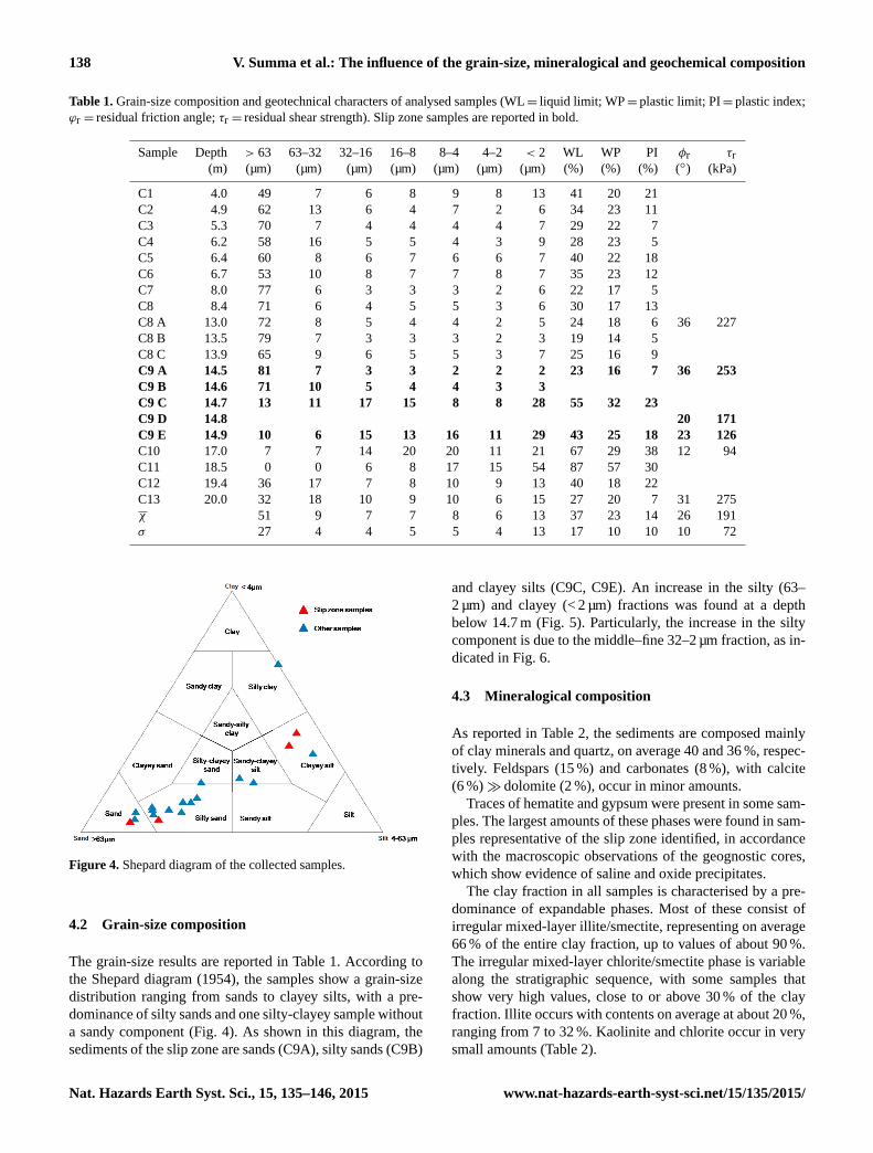
Table 1. Grain-size composition and geotechnical characters of analysed samples (WL= liquid limit; WP= plastic limit; PI= plastic index;
ϕr = residual friction angle; τr = residual shear strength). Slip zone samples are reported in bold.
Sample Depth > 63 63–32 32–16 16–8 8–4 4–2 < 2 WL WP PI φr τr(m) (µm) (µm) (µm) (µm) (µm) (µm) (µm) (%) (%) (%) (◦) (kPa)
C1 4.0 49 7 6 8 9 8 13 41 20 21
C2 4.9 62 13 6 4 7 2 6 34 23 11
C3 5.3 70 7 4 4 4 4 7 29 22 7
C4 6.2 58 16 5 5 4 3 9 28 23 5
C5 6.4 60 8 6 7 6 6 7 40 22 18
C6 6.7 53 10 8 7 7 8 7 35 23 12
C7 8.0 77 6 3 3 3 2 6 22 17 5
C8 8.4 71 6 4 5 5 3 6 30 17 13
C8 A 13.0 72 8 5 4 4 2 5 24 18 6 36 227
C8 B 13.5 79 7 3 3 3 2 3 19 14 5
C8 C 13.9 65 9 6 5 5 3 7 25 16 9
C9 A 14.5 81 7 3 3 2 2 2 23 16 7 36 253
C9 B 14.6 71 10 5 4 4 3 3
C9 C 14.7 13 11 17 15 8 8 28 55 32 23
C9 D 14.8 20 171
C9 E 14.9 10 6 15 13 16 11 29 43 25 18 23 126
C10 17.0 7 7 14 20 20 11 21 67 29 38 12 94
C11 18.5 0 0 6 8 17 15 54 87 57 30
C12 19.4 36 17 7 8 10 9 13 40 18 22
C13 20.0 32 18 10 9 10 6 15 27 20 7 31 275
χ 51 9 7 7 8 6 13 37 23 14 26 191
σ 27 4 4 5 5 4 13 17 10 10 10 72
Figure 4. Shepard diagram of the collected samples.
4.2 Grain-size composition
The grain-size results are reported in Table 1. According to
the Shepard diagram (1954), the samples show a grain-size
distribution ranging from sands to clayey silts, with a pre-
dominance of silty sands and one silty-clayey sample without
a sandy component (Fig. 4). As shown in this diagram, the
sediments of the slip zone are sands (C9A), silty sands (C9B)
and clayey silts (C9C, C9E). An increase in the silty (63–
2 µm) and clayey (< 2 µm) fractions was found at a depth
below 14.7 m (Fig. 5). Particularly, the increase in the silty
component is due to the middle–fine 32–2 µm fraction, as in-
dicated in Fig. 6.
4.3 Mineralogical composition
As reported in Table 2, the sediments are composed mainly
of clay minerals and quartz, on average 40 and 36 %, respec-
tively. Feldspars (15 %) and carbonates (8 %), with calcite
(6 %)� dolomite (2 %), occur in minor amounts.
Traces of hematite and gypsum were present in some sam-
ples. The largest amounts of these phases were found in sam-
ples representative of the slip zone identified, in accordance
with the macroscopic observations of the geognostic cores,
which show evidence of saline and oxide precipitates.
The clay fraction in all samples is characterised by a pre-
dominance of expandable phases. Most of these consist of
irregular mixed-layer illite/smectite, representing on average
66 % of the entire clay fraction, up to values of about 90 %.
The irregular mixed-layer chlorite/smectite phase is variable
along the stratigraphic sequence, with some samples that
show very high values, close to or above 30 % of the clay
fraction. Illite occurs with contents on average at about 20 %,
ranging from 7 to 32 %. Kaolinite and chlorite occur in very
small amounts (Table 2).
Nat. Hazards Earth Syst. Sci., 15, 135–146, 2015 www.nat-hazards-earth-syst-sci.net/15/135/2015/

V. Summa et al.: The influence of the grain-size, mineralogical and geochemical composition 139
Figure 5. Trend of grain size variation with depth.
Figure 6. Trend of silt fraction variation with depth.
www.nat-hazards-earth-syst-sci.net/15/135/2015/ Nat. Hazards Earth Syst. Sci., 15, 135–146, 2015

140 V. Summa et al.: The influence of the grain-size, mineralogical and geochemical composition
Table 2. Mineralogical composition of bulk rock and clay fraction (Qz= quartz; Fsp= feldspar; Cal= calcite; Dol= dolomite;
Hem= hematite; Gp= gypsum; Chl/Sme= chlorite/smectite; Ilt/Sme= illite/smectite; Kln= kaolinite; Chl= chlorite; Ilt= illite). Slip zone
samples are reported in bold.
Sample Depth (m) Bulk rock (%) Clay fraction (%)
Clay Qz Fsp Cal Dol Hem Gp Chl/Sme Ilt/Sme Kln Chl Ilt
C1 4.0 40 24 16 7 13 0 0 13 70 3 tr 13
C2 4.9 47 31 15 6 tr 0 tr 20 43 5 0 32
C3 5.3 32 39 23 5 tr 0 0 0 84 2 tr 13
C4 6.2 31 38 20 10 tr 0 0 18 47 4 tr 30
C5 6.4 45 31 16 8 tr 0 0 16 48 4 tr 31
C6 6.7 36 34 16 13 tr 0 0 0 72 3 tr 25
C7 8.0 18 61 18 3 0 0 0 35 41 3 2 20
C8 8.4 32 44 19 5 0 0 tr 0 73 4 4 20
C8 A 13.0 21 46 19 10 3 2 tr 0 84 2 2 11
C8 B 13.5 18 49 22 6 2 2 tr 18 53 3 6 20
C8 C 13.9 22 39 25 10 2 tr tr 0 78 3 2 17
C9 A 14.5 11 56 18 8 tr 5 tr 31 44 3 4 18
C9 B 14.6 28 41 16 9 4 2 tr 0 80 3 3 14
C9 C 14.7 53 28 12 tr tr 2 2 0 70 5 3 22
C9 D 14.8 53 30 9 6 tr tr 0
C9 E 14.9 57 28 7 2 2 2 3 0 68 5 3 24
C10 17.0 78 15 5 3 0 0 0 0 71 5 3 22
C11 18.5 93 7 0 0 0 0 tr 0 74 3 3 20
C12 19.4 53 32 13 2 0 0 0 25 64 3 tr 7
C13 20.0 32 45 16 6 0 0 0 0 88 3 tr 8
χ 40 36 15 6 2 1 1 9 66 3 2 20
σ 21 13 6 3 3 1 1 12 15 1 1 7
Figure 7. Trends of clay mineral content, quartz and K-feldspars
with depth.
From about 14.5 m below ground level, clay mineral
amounts increase significantly, and there is an abrupt reduc-
tion in the quartz-feldspathic component (Fig. 7).
4.4 Geochemical and hydrogeochemical characters
The results of the chemical analyses of the sediments are re-
ported in Table 3.
The pH of all samples is mainly neutral–alkaline, with a
maximum value of 8.7, with the exception of sample C11,
showing an acid character (pH 5.7), probably due to large
amounts of organic matter. The average quantity of the or-
ganic matter is about 30 g kg−1; however, this is variable and
significantly increases below a depth of about 14.5 m, in cor-
respondence to the slip zone. Corg and Ntot also increase at
this depth (Fig. 8). The Corg/Ntot ratio is a good indicator
of the degree of decomposition and the quality of organic
matter held in the soil (Batjes, 1996). The general trend of
the values suggests that a low Corg/Ntot ratio is indicative
of sediments containing relatively fresh organic matter, re-
flecting a greater degree of humification of organic matter,
as opposed to values greater than 50, where mineralisation is
favoured (Waksman, 1924; Parton et al., 2007; Russell et al.,
2009; Nadi et al., 2012; Fig. 9).
The sodium adsorption ratio shows a small variation at
the slip zone (Fig. 10). The cation exchange capacity in-
creases at the slip zone, decreasing progressively downward
(Fig. 10). In particular, at the slip zone, exchangeable magne-
sium and potassium increase, whereas exchangeable calcium
and sodium decrease (Fig. 11).
Nat. Hazards Earth Syst. Sci., 15, 135–146, 2015 www.nat-hazards-earth-syst-sci.net/15/135/2015/

V. Summa et al.: The influence of the grain-size, mineralogical and geochemical composition 141
Table 3. Chemical composition of analysed samples (Corg= organic carbon; Ntot= total nitrogen; OM= organic matter; C /N=C /N ra-
tios; SAR= sodium adsorption ratio; CEC= cation exchange capacity; ESP= exchangeable sodium percentage; EPP= exchangeable potas-
sium percentage; ECP= exchangeable calcium percentage; EMP= exchangeable magnesium percentage). Slip zone samples are reported in
bold.
Sample Depth pH Corg Ntot OM C /N SAR CEC ESP EPP ECP EMP
(m) (gkg−1) (gkg−1) (gkg−1) (meqL−1) (meq 100g−1) (%) (%) (%) (%)
C1 4.0 8.5 1.4 0.3 2.5 4.7 2.4 24 12.1 2.8 70.0 15.1
C2 4.9 8.6 0.1 0.2 0.2 0.5 2.8 22 12.7 1.6 76.1 9.6
C3 5.3 8.6 2.6 22 12.5 1.8 75.0 10.7
C4 6.2 8.6 0.2 0.2 0.4 1.0 4.3 23 12.4 1.4 74.6 11.6
C5 6.4 8.7 0.2 0.3 0.3 0.7 1.4 24 12.4 1.9 73.1 12.6
C6 6.7 8.6 1.6 22 12.4 1.8 74.8 11.0
C7 8.0 7.8 3.5 0.1 6.1 35.0 1.8 20 12.3 1.3 80.3 6.1
C8 8.4 7.8 7.0 0.3 12.1 23.3 1.8 21 12.1 1.3 78.3 8.3
C8 A 13.0 8.1 6.7 0.3 11.6 22.3 1.6 22 11.9 2.2 75.8 10.1
C8 B 13.5 8.1 4.2 0.1 7.2 42.0 1.4 19 12.5 1.2 82.2 4.1
C8 C 13.9 7.9 11.3 0.6 19.6 18.8 1.6 21 11.9 1.8 75.6 10.8
C9 A 14.5 7.9 5.3 0.1 9.1 53.0 1.4 20 12.0 1.4 80.6 6.0
C9 B 14.6 8.0 7.7 0.3 13.2 25.7 1.6 22 11.7 2.0 75.6 10.7
C9 C 14.7 7.3 22.4 1.1 38.6 20.4 1.1 24 11.1 3.7 70.4 14.8
C9 D 14.8 7.8 22.1 1.1 38 20.1 1.4 25 11.5 3.6 69.1 15.8
C9 E 14.9 6.9 38.7 1.4 66.7 27.6 1.0 27 10.7 2.8 72.4 14.1
C10 17.0 8.1 7.8 1.0 13.5 7.8 1.3 26 11.5 4.5 66.3 17.7
C11 18.5 5.7 169.4 4.0 292.0 42.4 1.5 21 14.5 3.9 56.8 24.8
C12 19.4 8.2 2.2 0.4 3.9 5.5 1.4 20 13.8 4.6 65.3 16.3
C13 20.0 8.5 4.8 0.4 8.3 12.0 1.5 19 14.2 2.5 69.9 13.4
χ 8.0 17.5 0.7 30.2 19.9 1.8 22 12.3 2.4 73.1 12.2
σ 1.0 39.2 0.9 67.5 14.9 0.8 2 0.9 1.1 5.9 4.7
Figure 8. Trends of organic matter (OM), organic carbon (Corg) and total nitrogen (Ntot) variations with depth.
www.nat-hazards-earth-syst-sci.net/15/135/2015/ Nat. Hazards Earth Syst. Sci., 15, 135–146, 2015

142 V. Summa et al.: The influence of the grain-size, mineralogical and geochemical composition
Figure 9. Total nitrogen (Ntot) vs. organic carbon (Corg) diagram.
Figure 10. Trends of pH, sodium absorption ratio (SAR) and cation exchange capacity (CEC) variations with depth.
Chemical analyses carried out of waters circulating in the
sediments of the landslide allowed the classification of these
waters into calcium bicarbonate facies (Fig. 12).
4.5 Geotechnical characters
The results of the physical–mechanical characterisation of
the samples tested are reported in Table 1.
Liquid limit (from 19 to 87 %) and plastic limit (from 14
to 57 %) are variable and abruptly increase at the slip zone,
below a depth of 14.7 m b.g.l. Plastic index is also variable,
and ranges from 5 to 38 %.
The residual friction angle ranges from 12 to 36◦, with
the lowest value detected in sample C10. The residual shear
strength ranges from 94 to 275 kPa. The slip zone samples
(C9A, C9D, C9E) show a progressive decrease in residual
shear strength with depth. The lowest value is detected in
sample C10, below the slip zone observed.
5 Discussion and conclusions
Statistically significant correlations between compositional
characters of sediments and their physical–mechanical prop-
erties were found.
The highest values of plasticity are linked to the largest
percentages of clay minerals, exchangeable magnesium and
potassium (Tables 1–3). The lowest values were observed in
samples also showing the highest residual friction angle.
Nat. Hazards Earth Syst. Sci., 15, 135–146, 2015 www.nat-hazards-earth-syst-sci.net/15/135/2015/

V. Summa et al.: The influence of the grain-size, mineralogical and geochemical composition 143
Figure 11. Trends of exchangeable sodium percentage (ESP), exchangeable magnesium percentage (EMP), exchangeable potassium per-
centage (EPP) and exchangeable calcium percentage (ECP) variations with depth.
Figure 12. Piper diagram of waters circulating in the landslide.
Correlations between silty fractions and the residual
friction angle were found. Particularly, the 32–2 µm frac-
tion is inversely correlated with the residual friction angle
(Fig. 13c), according to the increase in this grain-size frac-
tion in the samples from the slip zone (Fig. 6). Similarly, clay
mineral content is inversely correlated with residual shear
strength and the residual friction angle (Fig. 13a and b), in
accordance with the increase in this phase at the slip zone
(Fig. 7). Total nitrogen is also correlated negatively with
residual shear strength (Fig. 13d).
An inverse relationship between residual shear strength
and CEC was found, as well as between EMP, EPP and the
residual friction angle. Conversely, ECP is directly related to
the residual friction angle (Fig. 14). These correlations are
also in accordance with the respective depth trend (Figs. 10–
11).
These results allow the identification of some links be-
tween the compositional characters of the sediments and the
development of the slip zone. The increase in the 32–2 µm
fraction at the slip zone and its negative correlation with the
residual friction angle demonstrate that this grain-size frac-
tion can be a hazard factor with respect to the development
of the slip zone. The conditioning of the mineralogical com-
position on the mechanical behaviour of the sediments and
on the development of the slip zone is also well represented
by the depth trend of the clay mineral content, and by its
correlation with the residual friction angle and residual shear
strength. Conversely, the presence of sulfates (gypsum) and
iron oxides (e.g. hematite) at the slip zone could be a result
of a more significant fluid circulation, facilitating weather-
ing of sediments and deposition of new mineral phases, as a
result of ongoing oxidation and solubilisation–precipitation
processes.
Organic matter, increasing at the slip zone (Fig. 8), can be
considered a critical parameter with respect to the physical–
mechanical behaviour of the sediments, as already suggested
by other authors (Barras and Paul, 1999; Paul and Barras,
1999; Diaz-Rodriguez, 2003). The negative correlation be-
tween total nitrogen and residual shear strength allows us
to hypothesise a more significant influence of this parame-
ter, indicative of a more fresh organic matter than organic
carbon. In agreement with this hypothesis, one of the lowest
C /N ratios was detected (Table 3) in sample C10, showing
the lowest residual shear strength (Table 1).
Despite the slight variation in SAR at the slip zone, no sta-
tistically significant correlations with physical–mechanical
characters were found. As a result, SAR could not be iden-
www.nat-hazards-earth-syst-sci.net/15/135/2015/ Nat. Hazards Earth Syst. Sci., 15, 135–146, 2015

144 V. Summa et al.: The influence of the grain-size, mineralogical and geochemical composition
Figure 13. Correlations between residual friction angle (ϕr), residual shear strength (τr) and some compositional characters.
Figure 14. Correlations between some geochemical and mechanical characters (CEC= cation exchange capacity; EPP= exchangeable
potassium percentage; ECP= exchangeable calcium percentage; EMP= exchangeable magnesium percentage; τr = residual shear strength;
ϕr = residual friction angle).
tified as a clear hazard factor with respect to the slip zone
development. Conversely, the increase in CEC at the slip
zone and its negative correlation with residual shear strength
demonstrates that CEC can be considered a hazard factor
with respect to the slope stability.
The lowest value of residual shear strength detected in
sample C10 allows us to hypothesise a further deeper slip
zone, not detectable due to the upper crack in the inclinome-
ter tube, or a further weakness zone where it is more likely
that a future slip may occur. In accordance with this hypothe-
sis, some compositional characters recognised as hazard fac-
Nat. Hazards Earth Syst. Sci., 15, 135–146, 2015 www.nat-hazards-earth-syst-sci.net/15/135/2015/

V. Summa et al.: The influence of the grain-size, mineralogical and geochemical composition 145
tors contributing to the beginning of the movement in the slip
zone (such as the 32–2 µm fraction, clay mineral content and
CEC) still show high values in sample C10.
This study confirms the importance of compositional char-
acters of sediments in landslide processes, with respect to
their physical–mechanical behaviour and the position of the
slip zone. This demonstrates the need to carry out further spe-
cific investigations of the composition of terrain, in situ, to
understand slope stability. Furthermore, it is important to un-
derstand the water–rock interaction processes in areas where
landslides occur, in order to obtain further clues about the
mechanisms triggering the landslides.
Acknowledgements. The authors would like to thank the Adminis-
trative Province, Potenza, which provided borehole and geognostic
cores, and the Municipal Administration, Montemurro, for its
logistical support.
Edited by: V. Lapenna
Reviewed by: E. Tavarnelli and three anonymous referees
References
ASTM: ASTM Book of Standards, PA, ASTM, Philadelphia, 2007.
Barras, B. F. and Paul, M. A.: Sedimentology and depositional his-
tory of the Claret Formation (“carse clay”) at Bothkennar, near
Grangemouth, Scot. J. Geol., 35, 131–144, 1999.
Batjes, N. H.: Total carbon and nitrogen in the soils of the world,
Eur. J. Soil Sci., 47, 151–163, 1996.
Biscaye, P. E.: Mineralogy and sedimentation of recent deep-sea
clay in the Atlantic Ocean and adjacent seas and oceans, Geol.
Soc. Am. Bull., 76, 803–832, 1965.
Boenzi, F. and Ciaranfi, N.: Stratigrafia di dettaglio del “Flysch di
Gorgoglione” (Lucania), Memorie della Società Geologica Ital-
iana, 9, 65–79, 1970.
Boenzi, F., Ciaranfi, N., and Pieri, P.: Osservazioni geologiche nei
dintorni di Accettura e di Oliveto Lucano, Memorie della Società
Geologica Italiana, 7, 379–392, 1968.
Bogaard, T., Guglielmi, Y., Marc, V., Emblanch, C., Bertrand, C.,
and Mudry, J.: Hydrogeochemistry in landslide research: a re-
view, B. Soc. Geol. Fr., 178, 113–126, 2007.
Bucci, F., Novellino, R., Guglielmi, P., Prosser, G., and Tavarnelli,
E.: Geological map of the northeastern sector of the high Agri
Valley, Southern Apennines (Basilicata, Italy), J. Maps, 8, 282–
292, 2012.
Bucci, F., Novellino, R., Tavarnelli, E., Prosser, G., Guzzetti,
F., Cardinali, M., Gueguen, E., Guglielmi, P., and Adurno, I.:
Frontal collapse during thrust propagation in mountain belts: a
case study in the Lucania Apennines, Southern Italy, J. Geol. Soc.
London, 171, 571–581, 2014.
Buringh, P.: Organic carbon in soils of the world, in: The Role of
Terrestrial Vegetation in the Global Carbon Cycle: Measurement
by Remote Sensing, edited by: Woodwell, G. M., John Wiley and
Sons Ltd. Publications, New York, 91–109, 1984.
Butler, R. W. H. and Tavarnelli, E.: The structure and kinematics of
substrate entrainment into high concentration sandy turbidites: a
field example from the Gorgoglione “flysch” of southern Italy,
Sedimentology, 53, 655–670, 2006.
Cafaro, F. and Cotecchia, F.: Structure degradation and changes
in the mechanical behaviour on a stiff clay due to weathering,
Géotechnique, 51, 441–453, 2001.
Cello, G.: A quantitative structural approach to the study of active
fault zone in the Apennines (Peninsular Italy), J. Geodyn., 29,
265–292, 2000.
Cello, G., Gambini, R., Mattioni, L., Mazzoli, S., Read, A.,
Tondi, E., and Zucconi, V.: Geological analysis of the High Agri
Valley (Lucanian Apennines, southern Italy), Memorie della So-
cietà Geologica Italiana, 55, 149–155, 2000a.
Cello, G., Gambini, R., Mazzoli, S., Read, A., Tondi, E., and Zuc-
coni, V.: Fault zone characteristics and scaling properties of the
Val d’Agri Fault System (southern Apennines, Italy), J. Geodyn.,
29, 293–307, 2000b.
Cello, G., Tondi, E., Micarelli, L., and Mattioni, L.: Active tectonics
and earthquake sources in the epicentral area of the 1857 Basili-
cata earthquake (southern Italy), J. Geodyn., 36, 37–50, 2003.
Chapman, H. D.: Cation exchange capacity in methods of sediment
analysis – chemical and microbiological properties, Agronomy,
9, 891–901, 1965.
Cotecchia, F.: Mechanical behaviour of the stiff clays from the
Montemesola Basin in relation to their geological history and
structure, Charact. Eng. Proper. Nat. Sediment., 2, 817–850,
2003.
Critelli, S. and Loiacono, F.: Provenienza e dispersione dei sedi-
menti nel flysch di Gorgoglione (Langhiano-Tortoniano, Appen-
nino Lucano): implicazioni sull’evoluzione delle mode detritiche
arenacee nell’orogene sudappenninico, Memorie della Società
Geologica Italian, 41, 809–826, 1988.
Diaz-Rodriguez, J. A.: Characterisation and engineering properties
of Mexico City lacustrine soils, Charact. Eng. Proper. Nat. Sedi-
ment., 1, 725–755, 2003.
Di Maio, C.: The influence of pore fluid composition on the residual
shear strength of some natural clayey sediments, in: Proceedings
of 7th International Symposium on Landslides, Trondheim, Nor-
way, 17–21, 1189–1194, 1996a.
Di Maio, C.: Exposure of bentonite to salt solution: osmotic and
mechanical effects, Géotechnique, 46, 695–707, 1996b.
Di Niro, A., Giano, S. I., and Santangelo, N.: Primi dati
sull’evoluzione geomorfologica e sedimentaria del bacino
dell’alta Val d’Agri (Basilicata), Studi Geologici Camerti,
1992/1, 257–263, 1992.
Gueguen, E., Bentivenga, M., Colaiacovo, R., Margiotta, S., and
Summa, V.: The Verdesca landslide in the Agri Valley (Basil-
icata, Southern Italy): a new geological and geomorphological
framework, Nat. Hazards Earth Syst. Sci. Discuss., in press.
Loroueil, S. and Hight, D. W.: Behaviour and properties of natural
sediments and soft rocks, Charact. Eng. Proper. Nat. Sediment.,
2, 29–254, 2003.
Martinez-Nistal, A., Veniale, F., Setti, M., and Cotecchia, F.:
A scanning electron microscopy image processing method for
quantifying fabric orientation of clay geomaterials, Appl. Clay
Sci., 14, 235–243, 1999.
Moore, D. M. and Reynolds, R. C.: X-Ray Diffraction and the
Identification and Analysis of Clay Minerals, Oxford University
Press, 332 pp., 1989.
www.nat-hazards-earth-syst-sci.net/15/135/2015/ Nat. Hazards Earth Syst. Sci., 15, 135–146, 2015

146 V. Summa et al.: The influence of the grain-size, mineralogical and geochemical composition
Mutti, E. and Normark, W. R.: Comparing examples of modern
and ancient turbidite systems: problems and concepts, in: Marine
Clastic Sedimentology, edited by: Leggett, J. K. and Zuffa, G. G.,
Graham-Trotman, London, 1–38, 1987.
Nadi, M., Sedaghati, E., and Fuleky, G.: Evaluation of humus qual-
ity of forest soils with two extraction methods, Int. J. Forest Soil
Eros., 2, 124–127, 2012.
Parton, W., Silver, W. L., Burke, I. C., Grassens, L., Harmon, M. E.,
Currie, W. S., King, J. Y., Adair, E. C., Brandt, L. A., Hart, S. C.,
and Fasth, B.: Global-scale similarities in nitrogen release pat-
terns during long-term decomposition, Science, 315, 361–364,
2007.
Paul, M. A. and Barras, B. F.: Role of organic material in the plas-
ticity of Bothkennar clay, Géotechnique, 49, 529–535, 1999.
Russell, A. E., Cambardella, C. A., Laird, D. A., Jaynes, D. B., and
Meek, D. W.: Nitrogen fertilizer effects on soil carbon balances
in Midwestern US agricultural systems, Ecol. Appl., 19, 1102–
1113, 2009.
Shepard, F. P.: Nomenclature based on sand-silt-clay ratios, J. Sed-
iment. Petrol., 24, 151–158, 1954.
Sridharan, A.: Engineering behaviour of clays: influence of miner-
alogy, in: Proceedings of the Workshop on Chemo-Mechanical
Coupling in Clays, edited by: Di Maio, C. , Hueckel, T.,
and Loret, B., FromNano-Scale to Engineering Applications,
Maratea, Potenza, Italy, 3–28, 2001.
Summa, V., Tateo, F., Giannossi, M. L., and Bochicchio, A.: Re-
lazione finale di progetto, Monitoraggio della frana di Costa
della Gaveta del Comune di Potenza, Consiglio Nazionale delle
Ricerche, Istituto di Metodologie per l’Analisi Ambientale, Tito
Scalo, Potenza, Italy, 2007.
Summa, V., Tateo, F., Bochicchio, A., De Santis, F., Gian-
nossi, M. L., Margiotta, S., and Renna, A.: Relazione finale di
progetto, Monitoraggio e studio dei processi di alterazione dei
terreni in frana presenti nei centri abitati di Grassano, Latron-
ico e Tricarico, Consiglio Nazionale delle Ricerche, Istituto di
Metodologie per l’Analisi Ambientale, Tito Scalo, Potenza, Italy,
2008.
Summa, V., Tateo, F., Giannossi, M. L., and Bonelli, C. G.: In-
fluence of clay mineralogy on the stability of a landslide in
Plio-Pleistocene clay sediments near Grassano (southern Italy),
Catena, 80, 75–85, 2010.
Torrance, J. K.: Physical, chemical and mineralogical influences
on the rheology of remoulded low-activity sensitive marine clay,
Appl. Clay Sci., 14, 199–223, 1999.
Waksman, S. A.: Influence of microorganisms upon the carbon-
nitrogen ratio in the soil, J. Agr. Sci., 14, 555–562, 1924.
Zembo, I.: Stratigraphic architecture and quaternary evolution of
the Val d’Agri intermontane basin (southern Apennines, Italy),
Sediment. Geol., 223, 206–234, 2010.
Nat. Hazards Earth Syst. Sci., 15, 135–146, 2015 www.nat-hazards-earth-syst-sci.net/15/135/2015/