The Introduction of Price Signals into Land Use Planning Decision
22
LSE Research Online Article (refereed) The introduction of price signals into land use planning decision- making : a proposal Paul Cheshire and Stephen Sheppard LSE has developed LSE Research Online so that users may access research output of the School. Copyright © and Moral Rights for the papers on this site are retained by the individual authors and/or other copyright owners. Users may download and/or print one copy of any article(s) in LSE Research Online to facilitate their private study or for non-commercial research. You may not engage in further distribution of the material or use it for any profit-making activities or any commercial gain. You may freely distribute the URL (http://eprints.lse.ac.uk ) of the LSE Research Online website. You may cite this version as: Cheshire, P. & Sheppard, S. (2005). The introduction of price signals into land use planning decision-making : a proposal [online]. London: LSE Research Online. Available at: http://eprints.lse.ac.uk/archive/00000568 This is an electronic version of an Article published in Urban studies, 42 (4). 647 -663 © 2005 Taylor & Francis. http://www.tandf.co.uk/journals/titles/00420980.asp http://eprints.lse.ac.uk Contact LSE Research Online at: [email protected]
Transcript of The Introduction of Price Signals into Land Use Planning Decision

LSE Research Online Article (refereed)
The introduction of price signals into land use planning decision-
making : a proposal
Paul Cheshire and Stephen Sheppard
LSE has developed LSE Research Online so that users may access research output of the School. Copyright © and Moral Rights for the papers on this site are retained by the individual authors and/or other copyright owners. Users may download and/or print one copy of any article(s) in LSE Research Online to facilitate their private study or for non-commercial research. You may not engage in further distribution of the material or use it for any profit-making activities or any commercial gain. You may freely distribute the URL (http://eprints.lse.ac.uk) of the LSE Research Online website. You may cite this version as: Cheshire, P. & Sheppard, S. (2005). The introduction of price signals into land use planning decision-making : a proposal [online]. London: LSE Research Online. Available at: http://eprints.lse.ac.uk/archive/00000568 This is an electronic version of an Article published in Urban studies, 42 (4). 647 -663 © 2005 Taylor & Francis. http://www.tandf.co.uk/journals/titles/00420980.asp
http://eprints.lse.ac.uk Contact LSE Research Online at: [email protected]

Paul Cheshire, LSE
Stephen Sheppard, Williams College
Abstract Although directed to the British system of Town and Country Planning this paper has relevance for many OECD countries, including some with systems of land use regulation which evolved entirely independently of the British. The paper starts by characterising the basic features of the British land use planning system, viewed from the resource allocation point of view of an economist. A conclusion is that the system explicitly excludes any use of price signals from its decisions. The paper then summarises the problems which the exclusion of price information has given rise to. Because the UK planning system has deliberately constrained the supply of space, and space is an attribute of housing which is income elastic in demand, rising incomes not only drive rising real house prices but also mean that land prices have risen considerably faster than house prices. Several housing attributes other than garden space are to a degree substitutes for land but the underlying cause of the inelastic supply of housing in the UK is the constraint on land supply. The final section proposes a mechanism which would make use of the information embodied in the price premiums of neighbouring parcels of land zoned for different uses. Such premiums signal the relative scarcity of land for different uses at each location and should become a ‘material consideration’ in planning decision-making. If they were above some threshold, this should provide a presumption of development unless maintaining the land in its current use could be shown to be in the public interest. If combined with Impact Fees, such a change would not only make housing supply more elastic and the system more transparent but would help to distance land availability decisions from the political process. Corresponding author: Paul Cheshire Geography & Environment Dept London School of Economics London WC2A 2AE Tel: 020 7955 7586 email: [email protected]

The Introduction of Price Signals into Land Use Planning Decision-making: a proposal
1. Introduction The setting up of the Barker Enquiry in 20031 signalled not the end of an era but the beginning of the end of an era. Land use planning is about the allocation of a scarce resource to different uses but historically it has operated in a specialised arena of its own. As is argued below, the system explicitly excludes price information. Yet it has fundamental implications for both prices and, in wider terms, for economic competitiveness. Again, as is shown below, the effects on prices are incremental over time. Historically they have not been such as to attract the attention of mainstream economists or economic policy makers: until now. Now the impact on housing markets, and even on wider issues of macroeconomic policy and savings behaviour, has escalated to the point where land use planning has got onto the agenda of economic policy makers and finance ministers. This is not just the case in Britain. It is also true in the US: the June 2003 issue of the Federal Reserve Bank of New York Economic Policy Review was entirely devoted to the economic impacts of land use regulation. Planners have to adjust to a world in which the economic as well as the planning logic of what they do is not just analysed but is central to their concerns. This paper suggests a way in which price information could be effectively introduced into planning decision making while leaving the environmentally and the socially valuable functions of planning intact. The basic structure of land use planning in Britain was introduced in the 1947 Town & Country Planning Act. Although it has been amended and modified since then, it has remained unchanged both in terms of its fundamental aims and mechanisms. It is almost certainly the least changed feature of the sweeping changes introduced by the 1945 Attlee government. Its main aims were encapsulated in The Containment of Urban England (Hall et al., 1973). These were to: define urban envelopes outside which development would not be permitted; maintain open space both internally within built up areas but more particularly in Green Belts and other less stringently protected swathes of agricultural land surrounding urban areas; to promote orderly development; protect visual amenities; and prevent development in designated areas of countryside of special scenic importance2. Although the proposals outlined in this paper are focused on the British context, since systems based on the 1947 British system of Town and Country Planning were subsequently implemented in many
1 Established by Gordon Brown in his Budget speech: the enquiry was into the operation of the British housing market. Its remit specifically related to the potential impact of land use planning on housing supply and the instability of the British housing market. The review produced two reports (Barker, 2003 & 2004). The Interim report provided a great deal of valuable evidence on housing supply and its relation to land availability as well as an analysis of the workings of the planning system. The Final report’s recommendations were drawn within the framework of the existing planning system and proposed a stronger regional perspective and the introduction of housing affordability criteria in drawing up land release plans. The proposals required significant further work to be implemented, however, and tended to move in the direction of a master plan based system. It was recognised that solving problems created by regulation by the introduction of further regulations was a difficult task and that the speed of change would need to be strategically reviewed within a few years. In fact, the general election expected in 2005 put serious action on hold. 2 This is intentionally a simplified summary omitting some elements which were much discussed at the time (such as ‘betterment’ and development by the State) in order to focus on essential elements which have remained. In addition, the discussion below, in relation to the differences between the British system where the emphasis is on flexible development control in contrast to other systems which rely on the certainty of a zoning system, overstates the contrast.
1

other countries, the arguments made here have relevance far beyond Britain. Indeed with changes in the US and the growing application of growth boundaries to communities there, they have increasing relevance to systems of land use regulation not derived from the British experience. The process and procedures set up to make decisions within the new 1947 planning system were defined in purely administrative, legal and physical terms. Judgements as to whether development would reduce amenities or cause transport problems were on the basis of professional norms which were defined in physical terms but the parameters of which rested on purely subjective and/or aesthetic values. The system was developed on the basis of concepts such as 'housing need' (rather than demand), and on design norms with, for example, densities defined on physical criteria – so many dwellings per acre. Concepts such as 'visual amenity' had - and continue to have - an important role but were subjectively defined. Although in determining how much land to designate for housing development, population change and migration were allowed for, these were not and are not modelled or conceived of in ways that have become commonplace in labour economists’ studies of migration in which real labour market opportunities, differential house prices and, more recently, quality of life and local public goods (Gyourko & Tracy, 1991) played an important role; rather, they were modelled mechanically from supposed givens such as employment or 'land availability'. Similarly the driving force behind changes in 'housing need' (which were translated into changes in land availability via constant physical densities) in a locality was seen as changes in household numbers not changes in real incomes or relative prices that would affect the amounts of housing demanded. The whole planning system has thus grown up without any account being taken of price information or other economic indicators. The system decides the physical quantity of land to be made available for any given use but market forces then allocate such land to competing bidders. Moreover, no account is taken of the possibility that the most profitable use of land may be to leave it undeveloped to maintain the option of later development (Titman, 1985, Mayo and Sheppard, 2001). Land which has been made available for housing (or any other specified use) is deemed to be a part of land supply even though the owners of the land may rationally choose to keep such land vacant. This leads to a situation in which planners rationally decide that there is sufficient land available for housing (for example) because projections of household numbers at permitted densities can be accommodated on the land which has been designated but the available land is not developed either because the owners of designated land have objective functions which include other factors than direct monetary returns or – more probably given the pattern of land prices that has resulted from the constraints imposed on land supply – choose to keep the land vacant to retain the option of more profitable development at a later date. A further feature of the British planning system is that it rests on the process of 'development control'. Development is legally defined so that it is a right separated from freehold tenure of land. Development is defined to mean any change of designated use. This means that freehold tenure does not include rights to change the use of land. Uses are themselves legally defined so that the supply of land for each legally defined use is separately controlled by the planning system. Thus land which is designated for agricultural use cannot be converted to housing use without specific planning permission from the planning authority; but nor can a newspaper shop be converted into a betting shop or an estate agents without planning permission; nor an industrial building into offices or into housing.
2

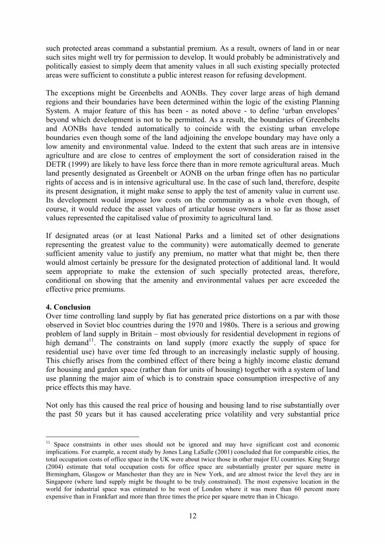
It is worth highlighting two aspects of this system which are peculiar to Britain (and to planning systems modelled on the 1947 Act elsewhere in the world). The first is the specific separation of ownership from development rights and the particular legal definition of what constitutes development. The second is the process of Development Control whereby permission has to be individually obtained for any change of use defined as development. This is in distinction to planning systems which use Zoning (as in the US) or a 'Master Plan' (applied in most of continental Europe) in which if a form of development is within the rules applying to that parcel of land then it can automatically be undertaken so long as it conforms to the plan and to other local regulations (such as safety or building regulations). As is shown in section 2 below, the allocation of land supply for each urban purpose by fiat quite independently of price has resulted over time in the emergence of very substantial price discontinuities for adjoining parcels of land. This is because although the total supply of land for each category of use in each locality is allocated independently of price, the market then allocates the determined supply of land for each use through the price mechanism to competing occupiers or developers. These price discontinuities, therefore, reflect the current expected degree of supply constraint on land for each type of planned use in each locality. So they provide a flexible price signal which will vary both over time and between cities yielding information about the relative scarcity of land for specific uses at that particular location and time. Land value discontinuities induced by development controls were explicitly considered in a static urban model in Sheppard (1988). Other factors can also result in discontinuities, such as the dynamic considerations introduced by Capozza and Helsley (1989; 1990). A stylised example, abstracting from these complexities, is illustrated in Fig 1. Fig 1a shows the zones determined at some date soon after 1947 accommodating three land uses – commercial, industrial and residential. At the containment boundary there was a discontinuity between the prices of agricultural land and land serviced for residential development because of the infrastructure costs embodied in the value of serviced land. Fig 1b illustrates the position as it evolved over time. As incomes rose and the structure of the local economy changed, the demand for commercial and for residential land rose relative to that for industrial and agricultural land. For the purpose of simplicity and exposition, it is assumed the zones of each land use did not change to accommodate these changes in demand. The prices of land for commercial and residential use were consequently bid up leading to the emergence of discontinuities in the land values of adjoining parcels in different use zones. Figure 1: The Emergence of Land Price Discontinuities in the Face of Fixed Supply 2. The economic background a) housing and land markets Over the past 35 years, there has been an increasing body of economic literature applying hedonic analysis to the housing market. The theoretical basis of this literature was provided in Rosen (1974) although as an empirical technique hedonic analysis precedes Rosen by more than 45 years. The basic idea is to conceive of complex goods such as houses as being composed of a bundle of attributes each of which commands a price that can be estimated and for each of which a conceptual and, in principle, identifiable market exists with its own supply and demand characteristics. In the case of housing the most important categories of attributes are those that relate to the physical structure (such as space, number of rooms, specification or design) and those that relate to its location (such as the character of the neighbourhood, the access it provides to the centre of employment, the quality of local schools or access to locationally fixed environmental amenities). For a recent literature survey and summary of progress in the hedonic study of housing and housing markets see Sheppard (1999).
3

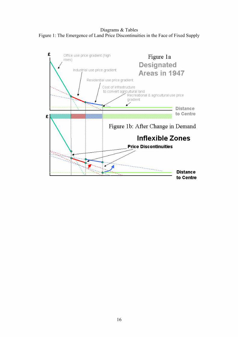
There have now been hundreds, perhaps thousands, of hedonic studies of housing markets undertaken around the world and no credible study has been done which has not found a strong and significant attribute price for internal space within the house. Far fewer studies have been done which include garden space3 but those which have been done similarly find that garden space itself is an attribute which commands a price. Findings of studies such as that by Song and Knaap (2003) that there is, other things equal, a price discount for houses in higher density neighbourhoods are essentially the flip side of the same coin. Table 1 shows a selection of attribute prices, and changes in them, estimated for the Reading area, a prosperous housing market about 60 kms west of London, at two different dates, 1984 and 1993. Both 1984 and 1993 represented periods of relative stability in house prices but 1993 was a low point following the collapse of the housing market boom after 1989. In 1993, compared to a 50 year average, house prices relative to earnings were close to a low – nationally the house price to earnings ratio fell 20 percent between 1984 and 1993 only to rise in the decade following 1993 by about 60 percent4. This probably accounts for the greater proportionate increase in incomes than in house prices between 1984 and 1993 in the Reading market. However, since here we are interested in the change in attribute prices relative to each other the cyclical movement of the housing market overall is not of major concern. It is immediately apparent that prices for attributes whose supply is relatively elastic, provided through a market process and produced by industrial means (such as central heating or simple changes to construction/design such as the number of bedrooms) fell in real terms between 1984 and 1993. In contrast, the price of those attributes not provided through markets but via fiat through the planning system, rose substantially in real terms. Not only that, but the price of garden space rose proportionately most where the supply was most constrained by the planning system: that is at the edge of the urban area where the containment policy was felt most strongly. Garden space nearer to the centre, although it cost more per square metre in absolute terms, increased in price proportionately less. The price of local public goods effectively bought through the housing market, such as access to the best secondary school, rose more or less in line with incomes. This is consistent with most of the costs of private schooling of similar quality - an obvious substitute - taking the form of labour costs. The reason for this pattern of price changes over time for specific attributes is the interaction of changes in the demand for, and supply of them. Evidence on the demand characteristics for individual housing attributes is relatively scarce but in a British context can be gleaned from Cheshire and Sheppard (1998) and Cheshire et al (1999). These estimates suggest that the demand for space was strongly income elastic. This was true both for internal and garden space. It was true across the three cities and for each period estimates were derived for: Darlington in 1984 and 1997, Nottingham in 1997 and Reading in 1984 and 1993. Not only was the income elasticity of demand for space strong but there was considerable stability in
3 Since economic theory tells one that the price of housing land will vary systematically with distance from employment centres it is not possible to estimate the price of garden space without also including the exact location of the house with respect to the centre(s) of employment. This also means that in any urban area there is not one price of land but a price function with respect to distance/location. It is consequently far more demanding to estimate the price of garden space in terms of both data requirements and estimation techniques. 4 See http://www.statistics.gov.uk/STATBASE/DatasetType.asp?vlnk=392 for the earnings index and using the Nationwide House Price Index.
4

the estimates over time and across housing markets. Evaluated at median observed incomes, the values varied from a low of 1.6 for internal space in Reading in 1984 to a high of 3.8 for garden space in Darlington in the same year. Four of the five estimates for the income elasticity of demand for garden space were higher than the corresponding estimates for internal space and the mean value of the income elasticity of demand for garden space was 2.4 compared to 2.0 for internal space. The evidence strongly suggests (the not surprising conclusion) that the demand for housing space - both internal and external - is normal with consumers seeking to buy more space as their incomes increase.
Table 1 : Changes in prices of selected attributes: Reading housing market, 1984-93 There seems, therefore, to be evidence supporting the conclusion that by restricting the supply of urban space in the face of rising real incomes and a normal income elasticity of demand for space – the operation of the planning system, especially in areas of high income growth such as Reading - has caused the price of space to rise significantly. If this is correct then a further implication is that over time the price of housing land should have risen in real terms more rapidly than the price of houses. This is because houses are composite goods and there is substitutability between attributes. If land becomes more expensive then more floors can be substituted for a larger floor plan, terraced or semi-detached houses can be substituted for detached houses or perhaps public open space can be substituted for garden space. Equally, more but smaller rooms with design features such as built-in storage can be substituted for larger rooms. So over time, if land prices rise as a result of a constraint on supply, design, densities and construction techniques are likely to adapt to substitute cheaper for more expensive attributes with the result that house prices rise less than land prices. Such a result is made even more likely if the apparent higher value of income elasticity of demand for garden space compared to internal space is supported by other evidence. There is in fact other evidence suggesting a higher income elasticity of demand for garden space. Although the focus of debate has been on the housing market, it is shown in Cheshire and Sheppard (2004) that over the long period the increase in land values (times a factor of 11 in real terms since 1955) greatly exceeded that of house prices (times a factor of 3.5 over the same period). Moreover, if there is an increasingly tight constraint on the supply of space one would expect an increasing degree of price volatility in the market. Adjustment to short run changes in demand has been increasingly through changes in price rather than quantity. This, too, is observed with the amplitude of the cycle increasing over time since the mid 1950s and being very much greater for land than it is for house prices. The evidence thus supports the view that the planning system constrains the supply of space (rather than the supply of houses) but space is an attribute not only demanded but one which is highly income elastic in demand. b) Discontinuities in the land value surface A further implication of this analysis is that the operation of the planning system in areas of demand growth (effectively all of the UK since demand is chiefly dependent on growth in real incomes – although with differential growth in the south east of England) would generate substantial discontinuities in land values over short geographical distances. This was illustrated in Fig 1 and results from the feature of the system discussed above: that it controls the supply of land for each category of use, individually, and independently of price. Thus if housing land is kept in short supply relative to market demand, its price at the urban fringe will rise above the combined value of land for agriculture and the infrastructure costs associated with converting it to housing. Similarly, if land for any other designated use is constrained relative to demand for it to a greater degree than the constraint imposed on the
5
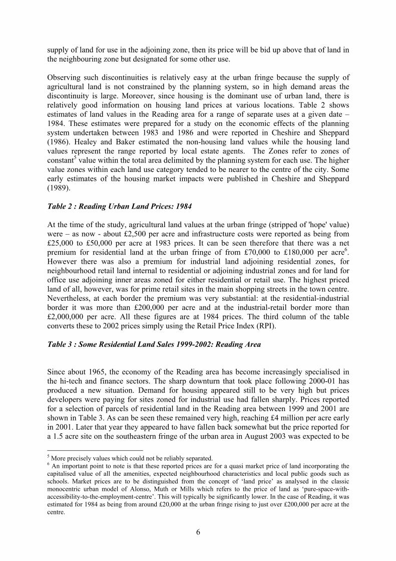
supply of land for use in the adjoining zone, then its price will be bid up above that of land in the neighbouring zone but designated for some other use. Observing such discontinuities is relatively easy at the urban fringe because the supply of agricultural land is not constrained by the planning system, so in high demand areas the discontinuity is large. Moreover, since housing is the dominant use of urban land, there is relatively good information on housing land prices at various locations. Table 2 shows estimates of land values in the Reading area for a range of separate uses at a given date – 1984. These estimates were prepared for a study on the economic effects of the planning system undertaken between 1983 and 1986 and were reported in Cheshire and Sheppard (1986). Healey and Baker estimated the non-housing land values while the housing land values represent the range reported by local estate agents. The Zones refer to zones of constant5 value within the total area delimited by the planning system for each use. The higher value zones within each land use category tended to be nearer to the centre of the city. Some early estimates of the housing market impacts were published in Cheshire and Sheppard (1989). Table 2 : Reading Urban Land Prices: 1984 At the time of the study, agricultural land values at the urban fringe (stripped of 'hope' value) were – as now - about £2,500 per acre and infrastructure costs were reported as being from £25,000 to £50,000 per acre at 1983 prices. It can be seen therefore that there was a net premium for residential land at the urban fringe of from £70,000 to £180,000 per acre6. However there was also a premium for industrial land adjoining residential zones, for neighbourhood retail land internal to residential or adjoining industrial zones and for land for office use adjoining inner areas zoned for either residential or retail use. The highest priced land of all, however, was for prime retail sites in the main shopping streets in the town centre. Nevertheless, at each border the premium was very substantial: at the residential-industrial border it was more than £200,000 per acre and at the industrial-retail border more than £2,000,000 per acre. All these figures are at 1984 prices. The third column of the table converts these to 2002 prices simply using the Retail Price Index (RPI). Table 3 : Some Residential Land Sales 1999-2002: Reading Area
Since about 1965, the economy of the Reading area has become increasingly specialised in the hi-tech and finance sectors. The sharp downturn that took place following 2000-01 has produced a new situation. Demand for housing appeared still to be very high but prices developers were paying for sites zoned for industrial use had fallen sharply. Prices reported for a selection of parcels of residential land in the Reading area between 1999 and 2001 are shown in Table 3. As can be seen these remained very high, reaching £4 million per acre early in 2001. Later that year they appeared to have fallen back somewhat but the price reported for a 1.5 acre site on the southeastern fringe of the urban area in August 2003 was expected to be
5 More precisely values which could not be reliably separated. 6 An important point to note is that these reported prices are for a quasi market price of land incorporating the capitalised value of all the amenities, expected neighbourhood characteristics and local public goods such as schools. Market prices are to be distinguished from the concept of ‘land price’ as analysed in the classic monocentric urban model of Alonso, Muth or Mills which refers to the price of land as ‘pure-space-with-accessibility-to-the-employment-centre’. This will typically be significantly lower. In the case of Reading, it was estimated for 1984 as being from around £20,000 at the urban fringe rising to just over £200,000 per acre at the centre.
6
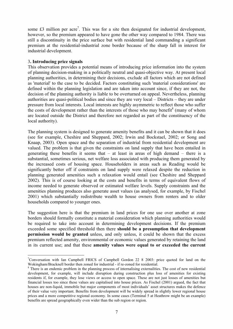
some £3 million per acre7. This was for a site then designated for industrial development, however, so the premium appeared to have gone the other way compared to 1984. There was still a discontinuity in the price surface but with residential land commanding a significant premium at the residential-industrial zone border because of the sharp fall in interest for industrial development. 3. Introducing price signals This observation provides a potential means of introducing price information into the system of planning decision-making in a politically neutral and quasi-objective way. At present local planning authorities, in determining their decisions, exclude all factors which are not defined as 'material' to the case to be decided. Factors constituting such 'material considerations' are defined within the planning legislation and are taken into account since, if they are not, the decision of the planning authority is liable to be overturned on appeal. Nevertheless, planning authorities are quasi-political bodies and since they are very local – Districts – they are under pressure from local interests. Local interests are highly asymmetric to reflect those who suffer the costs of development rather than the interests of those who may benefit8 (many of whom are located outside the District and therefore not regarded as part of the constituency of the local authority). The planning system is designed to generate amenity benefits and it can be shown that it does (see for example, Cheshire and Sheppard, 2002; Irwin and Bockstael, 2002; or Song and Knaap, 2003). Open space and the separation of industrial from residential development are valued. The problem is that given the constraints on land supply that have been entailed in generating these benefits it seems that – at least in areas of high demand – there is a substantial, sometimes serious, net welfare loss associated with producing them generated by the increased costs of housing space. Householders in areas such as Reading would be significantly better off if constraints on land supply were relaxed despite the reduction in planning generated amenities such a relaxation would entail (see Cheshire and Sheppard 2002). This is of course looking at the costs and benefits in terms of equivalent flows of income needed to generate observed or estimated welfare levels. Supply constraints and the amenities planning produces also generate asset values (as analysed, for example, by Fischel 2001) which substantially redistribute wealth to house owners from renters and to older households compared to younger ones. The suggestion here is that the premium in land prices for one use over another at zone borders should formally constitute a material consideration which planning authorities would be required to take into account in determining development decisions. If the premium exceeded some specified threshold then there should be a presumption that development permission would be granted unless, and only unless, it could be shown that the excess premium reflected amenity, environmental or economic values generated by retaining the land in its current use; and that these amenity values were equal to or exceeded the current
7Conversation with Ian Campbell FRICS of Campbell Gordon 22 8 2003: price quoted for land on the Wokingham/Bracknell border then zoned for industrial - if re-zoned for residential. 8 There is an endemic problem in the planning process of internalising externalities. The cost of new residential development, for example, will include disruption during construction plus loss of amenities for existing residents if, for example, they lose views or access to open space. These are not just losses of amenities but financial losses too since these values are capitalised into house prices. As Fischel (2001) argued, the fact that houses are non-liquid, immobile but major components of most individuals’ asset structures makes the defence of their value very important. Benefits from development will be widely spread in slightly lower regional house prices and a more competitive regional economy. In some cases (Terminal 5 at Heathrow might be an example) benefits are spread geographically even wider than the sub region or region.
7
premium. If this were the case then it would be deemed that the current use of the land was in the public interest. To implement such a change would require three problems to be solved. The first would be to provide a neutral mechanism for estimating current land values in any given use. Two methods suggest themselves. The Valuation Office through the district valuers already provides a service along these lines. Selective results are reported twice a year in their Property Market Report but in fact estimates are produced for all Districts. An alternative might be to require the would-be developer to provide market evidence and/or independent valuation evidence with respect to the premium. In England and Wales this has recently been made easier by the disclosure of price information by the Land Registry; in Scotland such information has traditionally been in the public domain. The planning authority could, of course, challenge such evidence. It might be reasonable to measure the mean premium over, say, two years rather than rely on a signal of perhaps a purely temporary shortage of supply. Markets can change rapidly, especially given the constraints on supply that have been accumulating since 1947 with the consequent price volatility and probably an increasing role of expectations about future price movements. As is discussed below, however, thresholds could be set high enough to resolve this problem. The second problem would be to determine the value of the threshold, a premium greater than which would constitute a material consideration generating a presumption of permission being granted. There are arguments on the side both of setting thresholds to reflect local factors and ensuring they are set nationally. It is our judgement that thresholds should be set according to nationally determined criteria because if set locally there would most likely be attempts to manipulate the threshold value effectively to maintain the status quo. On the other hand – and perhaps politically helpful in getting the mechanism accepted – the threshold could be determined in part as a function of local housing affordability – and set according to national criteria although the level might vary as the relevant local indicators varied. Because of cyclical factors and short run volatility in the demand for land for different uses there is a reasonable argument for setting thresholds at a significant positive value in order not to trigger land release in response to purely temporary conditions. Bringing new land into urban use imposes significant infrastructure costs. It would seem appropriate that the would-be developer should pay these. The full costs of development, however, include not just the infrastructure costs relating to the site itself and connecting it to road systems and utilities but the full financial costs to the community at large including additional policing, education, regional transport infrastructure etc made necessary by the development. It is useful to think about these two types of costs separately as:
1) Infrastructure directly associated with bringing the site into use (internal transport, sewage etc plus costs of connecting these services to local networks); and
2) The wider financial costs to the community external to the site itself. The first set of costs – those of ‘internal infrastructure’ - is already paid in kind by the developer so that there is an incentive to develop sites where such costs are minimised. Such costs are capitalised and so reflected (negatively) in the price a developer will pay for a site. Internal infrastructure costs are determined both by the nature of the site (brownfield sites tend to be significantly more expensive to develop than greenfield ones) and the regulatory
8

standards that are imposed by public authorities. The second set of costs – the 'Community costs' - should be charged as an Impact Fee, paid to the local authority9. At present there is a very imperfect system to defray the second set of costs based on the idea of ‘planning gain’ and implemented through ‘Section 106 Agreements’ negotiated between the local authority and the developer10. The aim is to negotiate some community benefit such as infrastructure, open space or affordable housing which the developer will pay for. These agreements have high transactions costs associated with them and are very imperfect. If changes to the planning system such as those proposed were implemented, the windfall gain from obtaining planning permission would be significantly eroded or eliminated, making it more difficult to obtain substantial gains from such agreements. Moreover, the outcome they produce depends on the skills of the negotiators and the particular circumstances of the parties involved, including current local political priorities and the news or political value of the agreements. Thus as well as being very imperfect in terms of outcomes, Section 106 Agreements generate a significant barrier to entry for new developers. They generate economies of scale for developers. The larger developers are, the more expertise they acquire both in terms of knowledge allowing them to target Section 106 Agreements to the particular concerns of local authorities and in terms of their ability to negotiate outcomes favourable to the developer. Since the aim of the changes proposed here is to move in the direction of a more objective and transparent, common currency of decision making, it would seem far more appropriate to replace Section 106 agreements with a simple Impact Fee as is frequently used in the US. Apart from the advantage of transparency, Impact Fees would generate a useful income stream for local government independent of central government and related to their needs. In contrast to the US, however, where total revenues from impact fees must be related to the costs that are deemed to be imposed by the development, we would argue that such revenues should not be hypothecated. Partly this reflects the traditional hostility of British governments to hypothecated taxes and the complexities that would be involved; partly it reflects the reality of current Section 106 Agreements which can cover a wide range of presumed community benefits; and partly it reflects the need to provide some incentive to Local Authorities to accept development. The Community costs of development vary from region to region depending on the extent to which there is spare capacity in existing transport networks, school systems etc. For 9 Note the proposal here is quite distinct from that for an Environmental Impact Fee in DETR (1999). The Urban Taskforce argued for such a fee to be added to existing land use controls. Since, however, land use planning is designed to safeguard amenities and is supposed to take into account social costs of development, such a fee added to existing controls would impose an undue burden on development in excess of its true social cost. In the context of the present proposal it makes far better sense to include these environmental costs of development explicitly in the estimation of the value of land in its present use. Thus if development of a particular parcel of land would impose environmental costs such, for example, as additional costs of global warming compared to present agricultural use, these should be included in estimating the social value of the land in its present use and therefore as a reason for maintaining a given level of price premium through a refusal of planning permission. A major purpose of the present proposal is to make such claims transparent so that the reasons for planning decisions are explicit and challengeable on the basis of the normal criteria used for resource allocation decisions in a market economy. Such a claim emphatically does not carry the implication that decisions made according to the price signals thrown up by markets are always socially optimal. In land markets this is seldom the case because of interdependencies of neighbouring land use and the importance of local public goods and amenities. Rather it is that unless there is a common yardstick, gross misallocation of resources and inefficiency can occur for negligible benefits. 10 These have their counterpart in the US system of ‘exactions’ which are payments developers are obliged to make in exchange for being granted building permits or variances from existing zoning regulations.
9
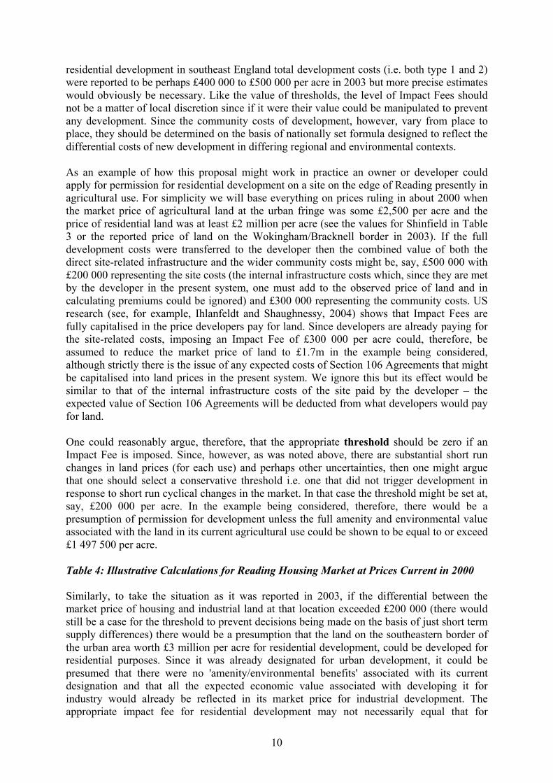
residential development in southeast England total development costs (i.e. both type 1 and 2) were reported to be perhaps £400 000 to £500 000 per acre in 2003 but more precise estimates would obviously be necessary. Like the value of thresholds, the level of Impact Fees should not be a matter of local discretion since if it were their value could be manipulated to prevent any development. Since the community costs of development, however, vary from place to place, they should be determined on the basis of nationally set formula designed to reflect the differential costs of new development in differing regional and environmental contexts. As an example of how this proposal might work in practice an owner or developer could apply for permission for residential development on a site on the edge of Reading presently in agricultural use. For simplicity we will base everything on prices ruling in about 2000 when the market price of agricultural land at the urban fringe was some £2,500 per acre and the price of residential land was at least £2 million per acre (see the values for Shinfield in Table 3 or the reported price of land on the Wokingham/Bracknell border in 2003). If the full development costs were transferred to the developer then the combined value of both the direct site-related infrastructure and the wider community costs might be, say, £500 000 with £200 000 representing the site costs (the internal infrastructure costs which, since they are met by the developer in the present system, one must add to the observed price of land and in calculating premiums could be ignored) and £300 000 representing the community costs. US research (see, for example, Ihlanfeldt and Shaughnessy, 2004) shows that Impact Fees are fully capitalised in the price developers pay for land. Since developers are already paying for the site-related costs, imposing an Impact Fee of £300 000 per acre could, therefore, be assumed to reduce the market price of land to £1.7m in the example being considered, although strictly there is the issue of any expected costs of Section 106 Agreements that might be capitalised into land prices in the present system. We ignore this but its effect would be similar to that of the internal infrastructure costs of the site paid by the developer – the expected value of Section 106 Agreements will be deducted from what developers would pay for land. One could reasonably argue, therefore, that the appropriate threshold should be zero if an Impact Fee is imposed. Since, however, as was noted above, there are substantial short run changes in land prices (for each use) and perhaps other uncertainties, then one might argue that one should select a conservative threshold i.e. one that did not trigger development in response to short run cyclical changes in the market. In that case the threshold might be set at, say, £200 000 per acre. In the example being considered, therefore, there would be a presumption of permission for development unless the full amenity and environmental value associated with the land in its current agricultural use could be shown to be equal to or exceed £1 497 500 per acre. Table 4: Illustrative Calculations for Reading Housing Market at Prices Current in 2000 Similarly, to take the situation as it was reported in 2003, if the differential between the market price of housing and industrial land at that location exceeded £200 000 (there would still be a case for the threshold to prevent decisions being made on the basis of just short term supply differences) there would be a presumption that the land on the southeastern border of the urban area worth £3 million per acre for residential development, could be developed for residential purposes. Since it was already designated for urban development, it could be presumed that there were no 'amenity/environmental benefits' associated with its current designation and that all the expected economic value associated with developing it for industry would already be reflected in its market price for industrial development. The appropriate impact fee for residential development may not necessarily equal that for
10

industrial development, but it is not obvious a priori, which would be greater. While residential development might be expected to impose greater costs for school building, industrial development might impose greater costs for police and fire protection or traffic congestion. For this example we assume the appropriate impact fee per acre developed would remain unchanged. This brings us to the third practical problem that would need to be solved: how amenity benefits could be estimated if the planning authority sought to object to the presumption of development. It is almost certain that such cases would arise, especially in the period immediately following the implementation of a system such as that proposed here. Where amenity benefits of open land accrue to local house owners then quite standard hedonic analysis can provide reasonable and defensible estimates of their value per acre. The great majority of non-urban land is in intensive agricultural use and provides low levels of such benefit (see, for example, Barker 2003). The values in Table 5 are per hectare not per acre and suggest the amenity value of intensive agricultural land is negligible and could therefore seldom be successfully cited as a public amenity defence for refusing development permission. They further suggest that public space in the urban core, such as parks or recreation areas, have the highest amenity value and so should generally be preserved from development. Clearly there are practical and intellectual problems in putting precise figures on the amenity and environmental value of land in any given use. The introduction of such a system, however, would immediately generate substantial incentives to devise and test credible methodologies. Moreover given existing research such as that summarised in Table 5 or Irwin (2002) on the value of intensively farmed agricultural land it does not seem likely that any credible methodology would give estimates of value in current use for such land remotely approaching its value for housing. This would very quickly lead to a very substantial increase in the supply of housing land. Table 5: Some recent estimates of values of non-urban land The likely result of implementing a change along the lines proposed would be that as the use of the new price information became established within the planning decision making process, new applications for development would be concentrated in locations in which permission would be virtually assured – i.e. on land currently in intensive agricultural use but with lower infrastructure costs; or land already designated for urban use but not for residential use. If this became the norm across the UK then not only would there be a rapid expansion of land supply for residential development but there would be a permanent change in expectations about future market values of land. Given the price volatility and very substantial long run real increase in developable land values the supply restrictions imposed since 1947 have generated, it is likely that expectations about future price movements have become influential drivers of behaviour for agents operating in the land market. So it seems plausible that a change such as that contemplated here would quite quickly substantially reduce the very large premiums now observed. There are National Parks, Areas of Outstanding Natural Beauty (AONBs) and other areas with specific protection (such as Sites of Special Scientific Interest) in regions of high demand. The full social value of such areas is unlikely to be capitalised into the housing market because of the extent to which they attract visitors from beyond the local area. In addition there is likely to be option and existence demand for such land that produces benefits to society as a whole rather than to those located nearby. This may also be true of the values of beautiful views although the evidence does suggest the value of views can get capitalised into land and house prices, as does immediate access to a major natural amenity, so sites in
11
such protected areas command a substantial premium. As a result, owners of land in or near such sites might well try for permission to develop. It would probably be administratively and politically easiest to simply deem that amenity values in all such existing specially protected areas were sufficient to constitute a public interest reason for refusing development. The exceptions might be Greenbelts and AONBs. They cover large areas of high demand regions and their boundaries have been determined within the logic of the existing Planning System. A major feature of this has been - as noted above - to define ‘urban envelopes’ beyond which development is not to be permitted. As a result, the boundaries of Greenbelts and AONBs have tended automatically to coincide with the existing urban envelope boundaries even though some of the land adjoining the envelope boundary may have only a low amenity and environmental value. Indeed to the extent that such areas are in intensive agriculture and are close to centres of employment the sort of consideration raised in the DETR (1999) are likely to have less force there than in more remote agricultural areas. Much land presently designated as Greenbelt or AONB on the urban fringe often has no particular rights of access and is in intensive agricultural use. In the case of such land, therefore, despite its present designation, it might make sense to apply the test of amenity value in current use. Its development would impose low costs on the community as a whole even though, of course, it would reduce the asset values of articular house owners in so far as those asset values represented the capitalised value of proximity to agricultural land. If designated areas (or at least National Parks and a limited set of other designations representing the greatest value to the community) were automatically deemed to generate sufficient amenity value to justify any premium, no matter what that might be, then there would almost certainly be pressure for the designated protection of additional land. It would seem appropriate to make the extension of such specially protected areas, therefore, conditional on showing that the amenity and environmental values per acre exceeded the effective price premiums. 4. Conclusion Over time controlling land supply by fiat has generated price distortions on a par with those observed in Soviet bloc countries during the 1970 and 1980s. There is a serious and growing problem of land supply in Britain – most obviously for residential development in regions of high demand11. The constraints on land supply (more exactly the supply of space for residential use) have over time fed through to an increasingly inelastic supply of housing. This chiefly arises from the combined effect of there being a highly income elastic demand for housing and garden space (rather than for units of housing) together with a system of land use planning the major aim of which is to constrain space consumption irrespective of any price effects this may have. Not only has this caused the real price of housing and housing land to rise substantially over the past 50 years but it has caused accelerating price volatility and very substantial price
11 Space constraints in other uses should not be ignored and may have significant cost and economic implications. For example, a recent study by Jones Lang LaSalle (2001) concluded that for comparable cities, the total occupation costs of office space in the UK were about twice those in other major EU countries. King Sturge (2004) estimate that total occupation costs for office space are substantially greater per square metre in Birmingham, Glasgow or Manchester than they are in New York, and are almost twice the level they are in Singapore (where land supply might be thought to be truly constrained). The most expensive location in the world for industrial space was estimated to be west of London where it was more than 60 percent more expensive than in Frankfurt and more than three times the price per square metre than in Chicago.
12

discontinuities for parcels of land that, while they are contiguous, are designated by the planning system for different uses. These price premiums provide direct information on the shortage of land in any locality for any particular use. Such price premiums should therefore be introduced as a material consideration in the planning decision making process with a presumption that, if they exceed some predetermined threshold, permission to develop will be granted unless the amenity values generated by the land in its current use are sufficient to show that it is in the public interest to maintain the existing use and refuse development. Given existing knowledge of such amenity values it seems most unlikely that such an argument could be sustained in the case of intensively farmed agricultural land. If Impact Fees were introduced then there would be an argument that the acceptable threshold above which a premium would trigger a presumption of development should be set at zero although because of short run price fluctuations and uncertainties it would probably be more appropriate to maintain a threshold significantly greater than zero. There would be serious disadvantages if land supply was allocated by the unregulated operation of the price mechanism because of the problems of market failure already noted. There are various ways in which the damaging effects of the types of market failure characteristic of land markets can be reduced and regulation – or planning – is one of them. On the other hand, except in the extreme circumstances of general mobilisation during war, the damaging effects of price distortions caused by regulation are rarely, if ever, improved by further regulation. In the housing field, the problems resulting from rent controls are an example of a case where further regulation failed. The solution, however, has not been total deregulation of housing markets but a degree of de-regulation and finding ways of introducing the valuable information contained in prices. While there are practical problems associated with introducing price signals into planning decision-making and there would certainly be political ones, there are no disadvantages in principle, provided that the market failures planning was designed to compensate for continue to be recognised. The proposals we have outlined in this paper are designed to do just that One of the advantages of introducing price signals into the planning decision making process is that it would achieve a similar degree of relaxation more or less everywhere, as indicated by the patterns of price premiums observed. This would tend to equalise regional house prices over the long term and so allow greater labour mobility. The constraint on land supply and so house prices bite sharpest in regions of high demand. This increases regional house price differentials and makes it harder for workers in less prosperous regions to move to where job prospects are better. This is particularly true for poorer workers in social housing. The proposal would, therefore, help resolve the so called North-South divide, help resolve problems of the supply of so-called key workers and housing affordability in regions of high demand and create greater labour market flexibility. The proposal would also have the considerable political merit of introducing a transparent, quasi-objective and so politically defensible mechanism into decisions about land supply. It would have parallels with making the Bank of England independent. It would help to distance land availability decisions from the political process. Clearly there would be political difficulties in introducing a reform as radical as that proposed here. Partly that is a problem of imagination: we are simply used to the system we have. But also there would be significant redistributative effects and people would seek to defend the value of their assets whether expensive space or the capitalised value of planning generated amenity benefits such as proximity to agricultural land. However space is enormously expensive because the planning
13

system has been controlling its supply independently of its price and that is what underlies the problem of housing supply in the UK; and, as was shown in Cheshire and Sheppard (2002), the amenity benefits – especially that which would be most affected, proximity to unbuilt land – are particularly regressive in their distribution: they are distributed even more inequitably than incomes of owner occupiers. So reforms along the lines proposed would both improve the operation of the housing market and in the long run have a progressive impact on the distribution of welfare across households. There would have been few observers who in 1992 would have predicted the Bank of England would be independent 5 years later. Making the planning system responsive to price signals and less arbitrary in its impact on land supply may seem problematic. But doing nothing is in the long run even more problematic. House prices may not collapse from the 2004 boom; but they may. We do know that if land supply does not become more responsive to underlying demand all the problems identified in section 2 of this paper will become cumulatively worse.
Acknowledgements We would like to thank Mr Ian Campbell, Professor HWE Davies, Dr Christian Hilber and Dr Murray Low for helpful comments and information. Only the authors should be blamed for the contents. References Barker, K. (2003) Review of Housing Supply: Securing our Future Housing Needs: Interim Report –
Analysis, London: HMSO. Barker, K. (2004) Review of Housing Supply: Final Report - Recommendations, London: HMSO. Capozza, D.R. and R.W. Helsley (1989) ‘The Fundamentals of Land Prices and Urban
Growth’, Journal of Urban Economics, 26, 295-306. Capozza D. R. and R.W. Helsley (1990), ‘The Stochastic City’, Journal of Urban Economics,
28 (2), 187-203. Cheshire, P. and S. Sheppard (1986) The Economic Consequences of the British Land Use Planning
System: a Pilot Study, Final Report to ESRC. Cheshire, P. and S. Sheppard (1989) ‘British Planning Policy and Access to Housing: Some Empirical
Estimates’, Urban Studies, 26, 469-485. Cheshire, P.C., and S. Sheppard, (1995) ‘On the Price of Land and the Value of Amenities’,
Economica, 62, 247-267. Cheshire, P.C., I. Marlee and S. Sheppard (1999) Development of a microsimulation model for
analysing the effects of the planning system housing choices: Final Report, Department of Geography and Environment, London School of Economics.
Cheshire, P.C., and S. Sheppard, (2002) 'Welfare Economics of Land Use Regulation', Journal of Urban Economics, 52, 242-69.
Cheshire, P.C. and S. Sheppard, (2004) ‘Land Markets and Land Market Regulation: progress towards understanding’, Regional Science and Urban Economics, 34, 6, 619-637.
Department of the Environment, Transport and the Regions (1999) Towards an Urban Renaissance: Final Report of the Urban Task Force Chaired by Lord Rogers of Riverside, London: HMSO.
Fischel, W. A. (2001) The Home Voter Hypothesis: How Home Values Influence Local Government Taxation, School Finance, and Land-Use Policies, Cambs, Mass: Harvard University Press.
Gyourko, J. and J. Tracy (1991) ‘The structure of local public finance and the quality of life’, Journal of Political Economy, 99, 774-806.
Hall, P.G., H. Gracey, R. Drewett and R. Thomas (1973) The Containment of Urban England, London: Allen and Unwin.
Ihlanfeldt, K. and T. Shaughnessy (2004) ‘An Empirical Investigation of the Effect of Impact Fees on Housing and Land Markets’, Regional Science and Urban Economics, 34, 6, 639-661.
14

Irwin, E. (2002) ‘The Effects of Open Space on Residential Property Values', Land Economics, 78, 465-481.
Irwin, E. and N. Bockstael (2002) ‘Interacting agents, spatial externalities and the evolution of residential land use patterns’, Oxford Journal of Economic Geography, 2, 31-54.
JonesLangLaSalle (2001) Commercial Real Estate Development and ‘City Offer’, London: JLL. King Sturge (2004) Global Industrial and Office Rents Survey, London: King Sturge. Mayo, S. and Sheppard, S. (2001) ‘Housing Supply and the Effects of Stochastic Development
Control’, Journal of Housing Economics, 10, 109-128. Riley, C. (2002) Comments on Mills and Evans, proceedings of seminar on Land Use Regulation,
Lincoln Institute for Land Policy, Cambridge Mass. Rosen, S. (1974) ‘Hedonic Prices and Implicit Markets: Product Differentiation in Pure Competition’
Journal of Political Economy, 82, 34-55. Sheppard, S. (1988) ‘The Qualitative Economics of Development Control’, Journal of Urban
Economics, 24, 310-330. Sheppard, S. (1999) ‘Hedonic Analysis of Housing Markets’, in Handbook of Regional and Urban
Economics Vol. III: Applied Urban Economics, edited by P.C.Cheshire and E.S. Mills, Elsevier Science Publishers.
Song, Y. and G. Knaap (2003) ‘New urbanism and housing values: a disaggregate assessment’, Journal of Urban Economics, 54, 218-238.
Titman, S. (1985) ‘Urban Land Prices under Uncertainty’, American Economic Review, 75, 505-514.
15
Diagrams & Tables Figure 1: The Emergence of Land Price Discontinuities in the Face of Fixed Supply
16
Table 1 : Changes in prices of selected attributes: Reading housing market, 1984-93
1984 1993 % Change
Income (pre-tax) from sample £13,694 £28,969 111.5
South East (Regional Trends) £12,896 £22,027 70.8 Price Level (1987=100) 91.0 141.9 55.9 Sample mean house price £51,066 £94,990 86.0 Reproducible attributes
Central heating £4,954 £5,997 21.1 Bedrooms £2,599 £2,801 7.8
Bathrooms + WC £4,687 £6,229 32.9
Planning amenities Less industrial land £74 £224 202.7
More open accessible land £51 £227 345.1 More closed unbuilt land1 £102 £60 - 41.2
Space (price per m2) Garden Space :
at centre
£49.5
£152.3
207.9 at periphery £4.5 £22.9 404.9
median distance £12.8 £32.1 151.5 Internal floorspace £171 £425 148.5 Local Public Goods
Best secondary school £7,090 £13,414 89.2 1Mainly agricultural land to which there are no significant rights of public access. 2 An estimate from data for 1999-2000 shows this price to have risen to £23,763.
Source: Reproduced from Cheshire and Sheppard 2004
17

Table 2 : Reading Urban Land Prices: 1984 Land Use £ 000’s per acre Current £ 000’s per acre 2002 prices Office use
Zone 1 7 964-13 2411 15 748-26 183 Zone 2 3 806-8 3701 7 526-16 551 Zone 3 2 621-5 1031 Zone 4 602-1 3081 1 190-2 586
Retail Zone 1a 28 779-34 1512 56908-67 531 Zone 1b 24 467-27 8182 48 382-55 008 Zone 2 12 807-15 7942 25 325-31 231 Zone 3 9 786-12 4582 19 351-24 635 Zone 4 8 941 17 680 Zone 5 3 020-3 9272 5 972-7 765 Zone 6 5 688 Zone 7 2 539 5 021
Industrial Zone 1 400* 791 Zone 2 500* 989 Zone 3 450* 890
Residential Edge of existing urban area 120-205 237-405
Source: Cheshire and Sheppard (1986) *Estimated variance ≤ 5% 1 Range of observations 2 Range of estimates varying with exact location and floor plan size/access/permitted structure type
18

Table 3 : Some Residential Land Sales 1999-2002: Reading Area
Source: Campbell Gordon, Reading
Address Size (Acres)
Land Sale Price £/m
Price Acre £/m
No of Units
Contract Date
Distance from
Centre in metres
READING, Addington House, 67-73 London Street
0.56 0.750 1.34 n.a. June 1999 600
READING, London Road/Silver Street (CITY POINT)
1.34 5.025 3.750 102 Flats
Sept 2000 600
READING, Shinfield Road, Met Office
44.6 Gross 19.37 Net
30.00 1.50 310 Houses
n.a. 2400
READING, 29 Queens Road,
0.53 2.12 4.00 46 Flats Jan 2001 450
READING, 4 Gas Works Rd
1.03 3.60-4.12 3.50-4.00 86 Flats Feb 2001 900
READING, 105/123 Queens Road
1.00 3.250 3.250 100/120 Flats
Spring 2001
450
READING, Berkeley Avenue, (CAPITAL POINT)
1.45 2.175 1.5 80 Flats Oct 2001 1000
READING, Shinfield Church Farm
13.89 Gross
10.07 Net
24.3 1.750 140 Houses
Sept 2001 3000
READING, Shinfield, Hollow Lane
10.625 Gross
9.79 Net
19.58 2.00 105 Houses
Oct 2001 3000
Table 4: Illustrative Calculations for Reading Housing Market at Prices Current in 2000 Cost per acre £ 1 Price of agricultural land 2 500 2 On site (internal) infrastructure costs 200 000 3 Community costs of development 300 000 4 Threshold 200 000 Sub total 702 500 5 Price of housing land plus internal infrastructure costs 2 200 000 6 Effective Premium* 1 497 500 *Calculated as Market price of housing land including costs paid by developer less items 1, 2, 3 & 4. Since of course item 2 appears as both a cost and in 5 for practical purposes it should be ignored and there would be no need to estimate it.
19

Table 5: Some recent estimates of values of non-urban land
Source: Adapted from Barker (2003) Table 1.6 and derived from ODPM Appraisal Guidance, Valuing the External Benefits of Undeveloped Land – a Review of the Economic Literature
Present value per ha Land Type External Benefits £ per ha per
year 2001 PV @ 3.5%
PV @ 6%
Urban Core Public space
Recreation, landscape tranquillity
54,000 10,800,000 1,800,000
Urban Fringe (Greenbelt)
Recreation, landscape, ecology 889 177,800 29,600
Urban Fringe (forested)
Recreation, landscape, tranquillity, ecology
2,700 540,000 90,000
Rural forested land (amenity)
Recreation, landscape, tranquillity, ecology
6,626 1,325,200 220,800
Agricultural land (extensive)
Recreation, landscape, cultural heritage, ecology
3,150 630,000 105,000
Agricultural land (intensive)
Landscape 103 20,600 3,400
Natural & semi-natural land (wetlands)
Recreation, landscape, ecology, hydrology
6,616 1,323,200 220,500
20