THE INFLUENCE OF THE HYDRAULIC EXCHANGE … -Volume9_issue_2 [email protected] ....
16
DOI 10.1515/pesd-2015-0037 PESD, VOL. 9, no. 2, 2015 THE INFLUENCE OF THE HYDRAULIC EXCHANGE RELATIONS IN THE EVOLUTION OF ICE JAM PHENOMENA ON BISTRIŢA RIVER IN THE AREA BETWEEN DORNA ARINI (SUCEAVA COUNTY) AND BORCA (NEAMŢ COUNTY) Gaman Claudiu 1 Key words: Bistriţa River, frazil slush, ice jam, hydraulic exchange relations Abstract. The presence on Bistriţa River, in identical climatic conditions, of sectors with well-developed ice formations in the immediate vicinity of river sectors lacking or with weakly developed such formations demonstrates the existence of other factors beside the meteorological and hydrological ones that may influence the evolution of freezing processes and implicitly of ice jams. A special role is held by the hydraulic exchange relations established between the river and the aquifers (Ciaglic, 1965; Ciaglic and Vornicu, 1973), the mentioned phenomena having a characteristic evolution, sometimes manifested through the total lack of ice due to underground input (Gaman, 2014). River alimentation from underground waters takes place in two situations: a) nearby well-developed alluvial fans close to floodplain or terraces; b) in areas where the river suddenly changes direction from flowing along one of the banks to an almost perpendicular position towards the valley, or where it meanders in the floodplain. The sectors of the river with areas of free water are those generating ice crystals and river-bottom ice and finally frazil slush. In the areas where the river loses water through infiltration in the floodplain, ice formations are much stronger according to the volume of water losses, and total freezing can be recorded. Field observations and measurements conducted in the winters of 2011-2012, 2012-2013, regarding the evolution of freeze phenomena, respectively ice jam formation, on Bistriţa River confirm the mentioned theory. Introduction After the emplacement of Izvoru Muntelui-Bicaz dam lake, in the river sector downstream Borca was produced a special type of ice jam, which may occur 2-3 times in a single winter (Romanescu, 2005; Romanescu and Bounegru, 2012; 1 ,,Alexandru Ioan Cuza” University of Iasi, Romania, Faculty of Geography and Geology [email protected]
Transcript of THE INFLUENCE OF THE HYDRAULIC EXCHANGE … -Volume9_issue_2 [email protected] ....

DOI 10.1515/pesd-2015-0037 PESD, VOL. 9, no. 2, 2015
THE INFLUENCE OF THE HYDRAULIC EXCHANGE
RELATIONS IN THE EVOLUTION OF ICE JAM PHENOMENA ON
BISTRIŢA RIVER IN THE AREA BETWEEN DORNA ARINI
(SUCEAVA COUNTY) AND BORCA (NEAMŢ COUNTY)
Gaman Claudiu1
Key words: Bistriţa River, frazil slush, ice jam, hydraulic exchange relations
Abstract. The presence on Bistriţa River, in identical climatic conditions, of sectors
with well-developed ice formations in the immediate vicinity of river sectors lacking
or with weakly developed such formations demonstrates the existence of other
factors beside the meteorological and hydrological ones that may influence the
evolution of freezing processes and implicitly of ice jams. A special role is held by
the hydraulic exchange relations established between the river and the aquifers
(Ciaglic, 1965; Ciaglic and Vornicu, 1973), the mentioned phenomena having a
characteristic evolution, sometimes manifested through the total lack of ice due to
underground input (Gaman, 2014). River alimentation from underground waters
takes place in two situations: a) nearby well-developed alluvial fans close to
floodplain or terraces; b) in areas where the river suddenly changes direction from
flowing along one of the banks to an almost perpendicular position towards the
valley, or where it meanders in the floodplain. The sectors of the river with areas of
free water are those generating ice crystals and river-bottom ice and finally frazil
slush. In the areas where the river loses water through infiltration in the floodplain,
ice formations are much stronger according to the volume of water losses, and total
freezing can be recorded. Field observations and measurements conducted in the
winters of 2011-2012, 2012-2013, regarding the evolution of freeze phenomena,
respectively ice jam formation, on Bistriţa River confirm the mentioned theory.
Introduction
After the emplacement of Izvoru Muntelui-Bicaz dam lake, in the river sector
downstream Borca was produced a special type of ice jam, which may occur 2-3
times in a single winter (Romanescu, 2005; Romanescu and Bounegru, 2012;
1 ,,Alexandru Ioan Cuza” University of Iasi, Romania, Faculty of Geography and Geology

The influence of the hydraulic exchange relations in the evolution of ice jam
200
Surdeanu et al., 2005), blocking the river floodplain on lengths of more than 20
km, frazil slush accumulation reaching depths of 1-8 m (fig. 1).
This type of ice jam has been first mentioned by Ciaglic et al. (1975). The
authors mention that the phenomenon includes two phases, the first one being
submerged, in which frazil slush brought by the river enters below the ice cover on
a certain distance. The damming of the section is made by the frazil slush which
sinks to the bottom of the old floodplain inside the lake (Călugăreni area) and not
by gradually attaching to the lower base of the ice layer (as it happens on rivers).
From here it gradually extends upstream in the floodplain, filling it and in many
cases passing over the river banks (the emerged phase) (fig. 2 A, B).
Fig. 1. Variations of the ice jam maximum lengths and heights on Bistriţa River (sector
between Izvoru Muntelui-Bicaz dam lake and the limit with Suceava County) during 2002-
2014 (Gaman, 2014)
A B
Fig. 2. Ice jams on Bistriţa River: A. on the entire river surface, downstream Frumosu
hydrometric station, 28.01.2014; B. with thawed channel, upstream Topoliceni dam,
01.02.2014

Gaman Claudiu
201
The purpose of this study has been of identifying some solutions to reduce the
intensity of the frazil slush flows and implicitly of the ice jams, having in view that
Ciaglic (2008, 2009) considers that for the substantial diminishment of the effects
of the phenomenon it is necessary to act against the causes.
Geographic position and limits
Bistriţa River, the most important tributary of Siret with an length of 278.8 km
(Cojoc et al., 2014; Ujvari, 1972), is on more than two thirds a mountainous,
Carpathian river. From its spring area (Rodna Massif) and up to Piatra Neamţ,
Bistriţa valley, with a NNW-SSE direction, drains mountainous massifs that belong
to two large units of the Eastern Carpathians, respectively the Northern
(Maramureş and Bucovinei Mts.) and the Central Unit (the Moldo-Transylvanian
Carpathians) (Velcea and Savu, 1982).
Fig. 3. Geographic position of Bistriţa basin in the study area (RMD CONSULT, 2009)
We have extended the researches in Suceava County, from Dorna Arini
village (at the confluence with Neagra Şarului), up to Borca town (Neamţ County),
The influence of the hydraulic exchange relations in the evolution of ice jam
202
having in view that the source of ice formations (ice packs and frazil slush) that
reach the entrance into Izvoru Muntelui-Bicaz lake come from this area. Ciaglic,
cited by Rădoane et al. (2009), mentions that in the Rusca-Crucea-Cotârgaşi area
(fig. 3) occur the strongest and longest as duration frazil slush flows, due to the
morphological characteristics of Bistriţa’s floodplain, which in cross-section
presents alternations of riffle and pools (laminar flow which favors the formation
of ice crystals) and slope breaks (with high roughness and turbulent flow that favor
the formation of river-bottom ice), essential conditions for the occurrence of frazil
slush flows.
Results and discussions
According to the evolution of freeze processes, respectively ice jams, along
Bistriţa River, three sectors have been delimited during the field observations from
the 2011-2012 and 2012-2013 winters.
The first river sector occupies the entire depression of Dorna up the southern
(downstream) limit of Rusca village (the confluence with Osoi brook). The ice jam
is the formation with the largest occurrence, spread, duration and thickness. Ice
presents an obvious stratification: an upper thin layer (2-3 cm) formed of frozen
snow; a medium layer of crystalline ice with thicknesses of 20- 40 cm and a lower
layer formed of frazil slush deposited at the lower part of the crystalline ice jam,
with a variable depth and undulated lower surface (at the contact with the water)
(fig. 4).
Fig. 4. Massive ice fragments brought from Ortoaia (upstream Zugreni dam) that have
passed over the shuttle, remaining on land at its base (ice thickness and stratification can be
observed), 01.04.2012
Gaman Claudiu
203
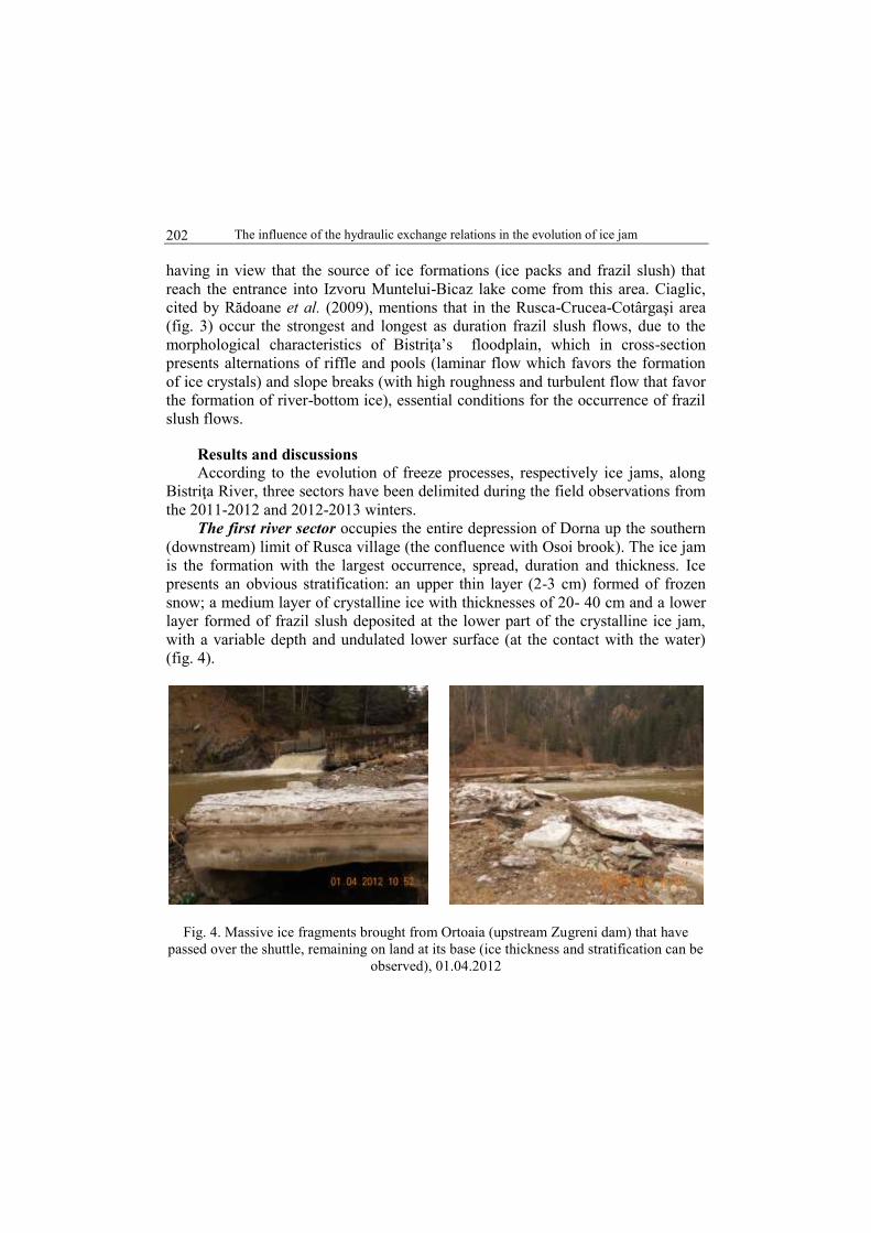
In this sector ice jams occur periodically both on Bistriţa and its larger
tributaries. The ice jams during the freeze period are less dangerous, because in
many situations they do not end in river blocking and floods, and frazil slush
accumulation (fig. 5) under the ice bridge is slow.
It is a new (beginning) stage in which are found the conditions for the
formation of a new, intermediary type of ice jam (Ciaglic, 2008). It is the most
dangerous type of ice jam (in what regards the damages inflicted), reaching
impressive dimensions both as surface occupied and depth, being formed in the
middle of the winter, in January-February (fig. 6 A, B, C).
Fig.5. Frazil ice flows on Bistriţa,
2011-2012 winter
Fig. 6 A. Settlements flooded during ice jam
formation upstream Vatra Dornei (photo
Hociung C.)
Fig.6 B. Works of removing ice jams
from the Bistriţa floodplain,
(photo Gavril Petrică)
Fig.6 C. Evacuation of ice packs reaching
DN 17B national road, Suceava County
(photo Gavril Petrică)
The influence of the hydraulic exchange relations in the evolution of ice jam
204
The main cause for the occurrence of this ice jam type is the invasion of more
humid and warmer Atlantic air masses through the Bârgae-Dorna Couloir in the
Dorna Depression (Surdeanu et al., 2005). In this way ice packs resulting from the
fragmentation of the ice bridge are overimposed on the frazil slush agglomerations.
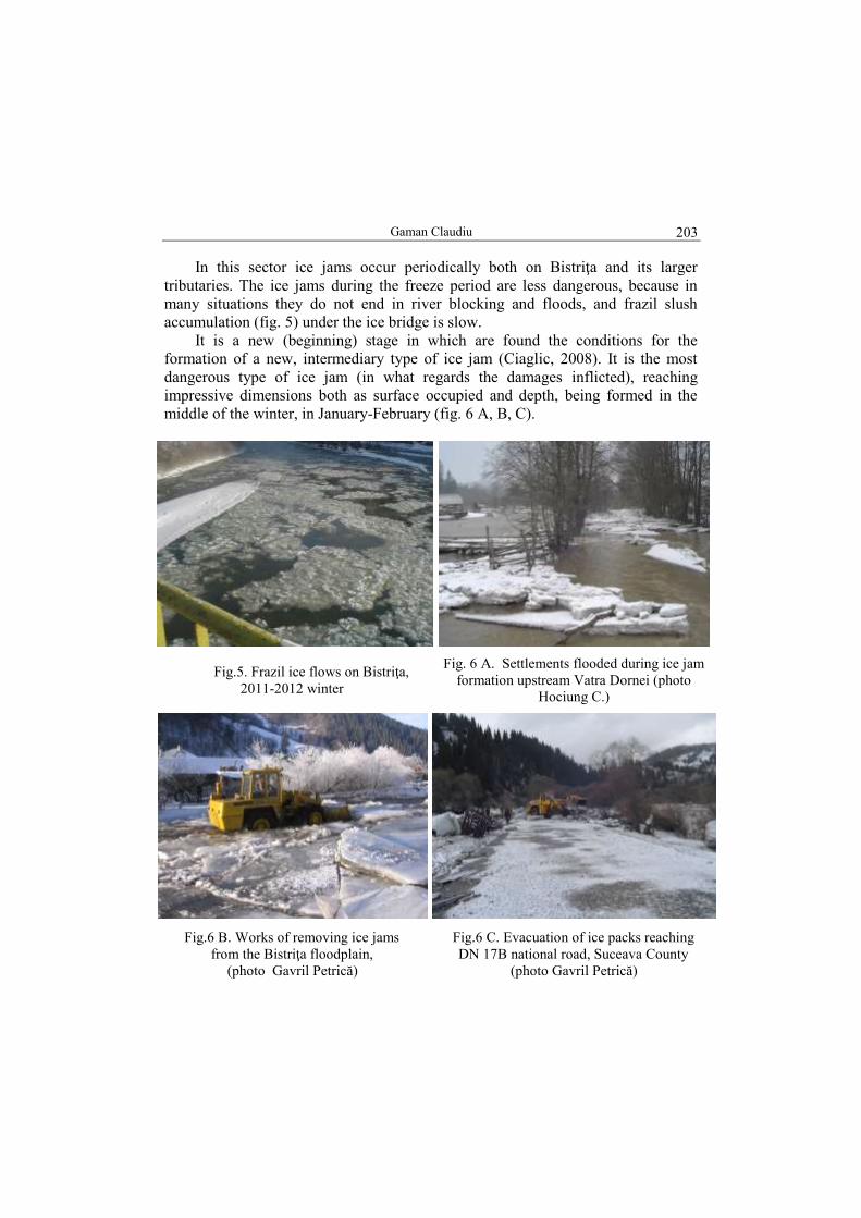
The second sector starts downstream Rusca (north, the confluence with Osoi
brook), and ends downstream the confluence with Căpriţa brook. Along this sector
are distinguished three almost equal compartments: at north between the
confluence of Osoi and Chiril brooks, Zugreni Gorges; in the central part, between
Chiril and Crucea brooks, a depression basin; downstream, between Crucea and
Căpriţa brooks, the Toancele Gorges, the narrowest and deepest valley sector.
Fig.7. Map of ice jam formations along Bistriţa in the Zugreni (Suceava County) - Borca
(Neamţ County) sector (10.03.2012), (Gaman, C., Ciaglic, V.)
A general characteristic of the evolution of ice jam formations on the entire
Bistriţa valley downstream Osoi brook (the southern limit of Dorna depression)
and up to Izvoru Muntelui Lake is represented by their alternation (fig. 7): shore
ice, different types of ice bridges (with spaces, channels or complete). The

Gaman Claudiu
205
occurrence of these ice formations is relatively sudden on the entire mentioned
river length, but the ice bridges disappear fast enough (a few days) even if air
temperature is maintained relatively low or decreases easily. Only the shore ice,
with variable widths, remains. At the same time, in the erosion basins, at the
upstream part of the floodplain terraces, occurs a patch of free water along the
banks. This is the area through which underground water from the floodplain
deposits (gravel, boulders) enters the river. The same phenomenon can be seen at
the downstream part of the alluvial cones neighboring the high floodplain.
In what regards the freeze ice jams (dams), they occur very rarely, being
normally small, just like the thaw ones. In the last case, the ice floes flows of low
intensity do not lead to blockings of the river section, because the thaw occurs
beginning from the southern lower area and slowly propagates towards the higher
north spring area, the floodplain being cleaned from the floes downstream.
In this sector the most dangerous are also the ice floes occurring after the
sudden release of intermediary type ice jams from the Dorna Depression. These are
conditioned by the transport capacity of the river floodplain in the moment when
ice jams in the southern part of Dorna Depression are broken. In the case when the
floodplain transport capacity is reduced, a part of the floes remain on the banks and
another are retained in the area of the previous dam from Zugreni (fig. 8). In the
case when the floodplain transport capacity is high (large liquid discharge) the
ice floes overcome the Zugreni dam locks (fig. 9) and can reach downstream the
Frumosu village. They can even connect with the atypical ice jam formed almost
exclusively out of frazil slush accumulations which is propagated from Izvoru
Muntelui-Bicaz Lake upstream. In this type of situation have been registered the
largest losses, including human lives, in January 2003 (fig. 10).
Fig. 8 Ice floes deposited upstream the ex-dam of Zugreni on the river banks (01.04.2012,
photo Gaman C.) and in the previous lake area (March 2008, photo Rădoane M.)

The influence of the hydraulic exchange relations in the evolution of ice jam
206
The most powerful ice jams occur in the compartment from the central Chiril-
Crucea area. The most affected points are the following: in the meander of Bistriţa
just downstream of Cojoci village; in the tight curve downstream Satul Mare
village; upstream Dâmbul Colacului village (the largest ice jams) and immediately
upstream the confluence with Crucea village. As the ice floes flows go
downstream, they lose intensity and a large part of them are retained on the river banks in the area of the ice dams from upstream.
Fig. 9 Ice floes deposited 1 km upstream Zugreni dam and downstream Crucea township,
01.04.2012
Fig. 10 Properties affected by ice jams in Farcaşa village, January 2003
The last compartment of the second river sector, between Crucea village and
Căpriţei brooks, corresponds to Toancelor Gorges, where the floodplain is narrow
and presents many sectors with almost vertical walls. On this river sector freeze
and thaw ice jams are small and of short duration (in case they occur), without

Gaman Claudiu
207
Fig. 11. Gorges and depression basins along Bistriţa (Donisă, 1968)
Ice bridge with small holes at about 8 km from
Holda
Bistriţa river – thawing along the banks and
ice bridge with snow at Holda
Ice bridge with snow, upstream the bridge,
Broşteni
Ice bridge with channel downstream bridge at
Lunca (downstream the confluence with
Cotârgaşi brook)
Fig. 12. Ice formations on Bistriţa, Suceava County, March 2012

The influence of the hydraulic exchange relations in the evolution of ice jam
208
dangerous effects. The intermediary ice jams are also weakly manifested in this
area, because most of the ice floes have been retained upstream in the Chiril-
Crucea erosion basin.
The third sector, Căpriţei brook up to Izvoru Muntelui-Bicaz Lake, is
characterized by a widening of the valley downstream, with narrow sectors
between those of the erosion depression basin types. From the north part of the
sector, these are the erosion basin of Holda-Broşteni, the narrowing from
Cotârgaşi-Pietroasa, the depression basin of Lunca-Mădei-Sabasa-Pârâul Pântei,
the narrowing from Piciorul Comorii, Stejaru-Farcaşa basin, a short narrowing at
Buşmei, Popeşti-Galu basin, the narrowing immediately downstream from Galu
brook, after which the valley widens more and more up to the Izvoru Muntelui-
Bicaz Lake (fig. 11). Winter phenomena in this last sector of Bistriţa river are the
same as in the second (Osoi-Căpriţei brook) and their evolution is similar (fig. 12).
The dangerous ice jams (dams) are also those of intermediary type. The large
distance from the area of origin of the massive ice floes flows (Dorna Depression)
attenuates their effect as they move downstream. The most exposed areas for this
type of ice jams are: upstream Holda, upstream Holdiţa, upstream the Neagra-
Broşteni confluence and upstream Pietroasa brook. Yet, in some years ice floes
have reached Frumosu hydrometric station, uniting with the massive frazil
agglomerations of the ,,atypical-anthropic” ice jam from the entrance into Izvoru
Muntelui-Bicaz Lake.
We have insisted on following the evolution of the freeze phenomena on
Bistriţa River with the purpose of identifying a solution that would reduce the
intensity of frazil slush flows.
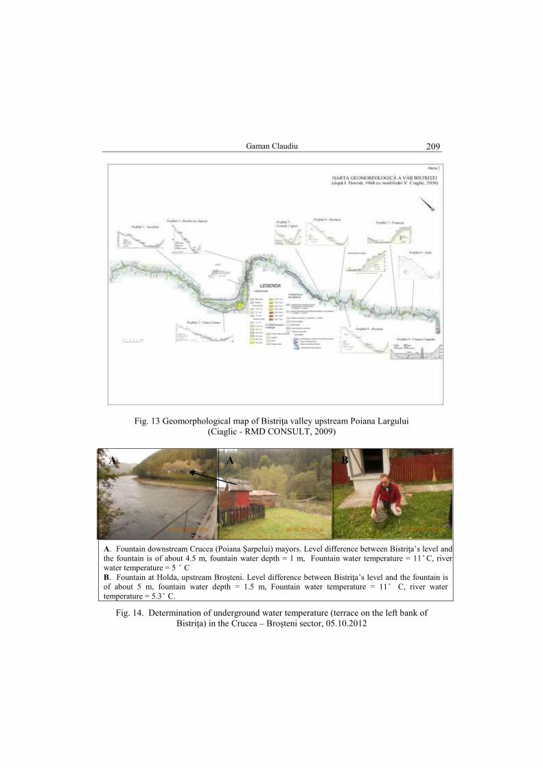
In this regard, during the winter of 2012-2013 have been studied on field the
areas with hydraulic exchange (fig. 13), conducting measurements of the river
water (longitudinal thermal profile) and of that from the aquifers from Bistriţa’s
terraces (fig. 14 A, B, 15, 16 and 17). Unfortunately on Bistriţa haven’t been
conducted discharge measurements for the establishment of a hydric balance for
the analyzed sectors. Still the theory regarding hydraulic exchange has been
confirmed for Bistricioara river by Ciaglic and Vornicu (1965, 1973) after
measurements conducted in 1963-1965 (the loses through infiltration varying in
certain areas between 19.5 % and 71.4 % and the underground input reaching in
some cases 49.5 %).
Upstream the fountain in figure 14 a, Bistriţa (water temperature = 4.4 ̊C)
loses water in underground by infiltration (in the area of Crucea mayors), after
going downstream through the left bank terrace deposits the water reaching 11 ̊ C.
In the discharge area (photo bridge with cable) river water temperature has
increased by 0.6 ̊ C.
Gaman Claudiu
209
Fig. 13 Geomorphological map of Bistriţa valley upstream Poiana Largului
(Ciaglic - RMD CONSULT, 2009)
A. Fountain downstream Crucea (Poiana Şarpelui) mayors. Level difference between Bistriţa’s level and
the fountain is of about 4.5 m, fountain water depth = 1 m, Fountain water temperature = 11 ̊ C, river
water temperature = 5 ̊ C
B. Fountain at Holda, upstream Broşteni. Level difference between Bistriţa’s level and the fountain is
of about 5 m, fountain water depth = 1.5 m, Fountain water temperature = 11 ̊ C, river water
temperature = 5.3 ̊ C.
Fig. 14. Determination of underground water temperature (terrace on the left bank of
Bistriţa) in the Crucea – Broşteni sector, 05.10.2012
A A B

The influence of the hydraulic exchange relations in the evolution of ice jam
210
Bistriţa river, about 150 m downstream the confluence with Arşiţei brook,
water temperature = 3.4 ̊C (left); Fountain on the right bank at Rusca,
water depth = 1 m, water temperature = 10 ̊ C (center); Bistriţa river near the fountain (water
temperature = 4 ̊ C), (right).
Fig. 15. Temperature input (0.6 ̊ C) from the underground water of the right-side terrace of
Bistriţa at Rusca, Suceava County, 11.11.2012 (air temperature = 2 ̊ C at 11.44 hours).
Rusca brook at the confluence with Bistriţa, water temperature = 5.5 ̊C (left); Discharge from the right
bank terrace, water temperature = 8.9 ̊C, (center); Bistriţa river, downstream the confluence with
Rusca, water temperature = 4.3 ̊C (right)
Fig. 16. Thermal input (0.3 ̊ C) coming from tributaries and aquifers of the right-bank
terrace downstream the confluence with Rusca 11.11.2012 (air temperature = 4 ̊ C).
Fountain at the entrance in Chiril Fountain at Cojoci
Fig. 17. Measurements of water temperature from the aquifers of alluvial fans from the left
side of Bistriţa. Water depth = 1 m, water temperature = 9 ̊ C, air temperature = 7 ̊ C,
11.11.2012

Gaman Claudiu
211
Downstream the confluence with Chiril water temperature in Bistriţa rose
from 4 ̊ C (downstream the fountain) to 5 ̊ C (thermal input of 1 ̊ C coming from
the brook’s alluvial fan). Water temperature remained stable up to Satu Mare
village, where it increased up to 5.5 ̊ C (thermal input from the aquifer of the
alluvial fan from Bistriţa’s left side, downstream Colacului).
In the sector downstream the confluence with Crucea (water temperature = 6 ̊
C) and downstream the confluence with Holda (upstream Broşteni village) river
water temperature increased by 1.5 ̊ C. Air temperature at 15.50 was of 8.5 ̊ C.
Conclusions
The presence on Bistriţa River, in identical climatic conditions, of sectors with
well-developed ice formations in the immediate vicinity of river sectors lacking or
with weakly developed such formations demonstrates the existence of other factors
beside the meteorological and hydrologic ones that may influence the evolution of
freezing processes and implicitly of ice jams (Gaman, 2014b). The areas with free
water surfaces are “generators” of ice crystals and river-bottom ice, and in
consequence of ice jams.
A very important role is held by the thermal input due to the hydraulic
exchange between Bistriţa and its tributaries (in one direction) and the
underground waters (in both directions simultaneously) from the homogeneous
strata formed of gravel, boulders and sands (alluvial deposits from the floodplain of
Bistriţa and its terraces, of the main tributaries and the proluvio-coluvial deposits
of the alluvial fans and glacises from the footslopes).
Area of aquifer downstream discharge Ice bridge covered by snow upstream
Fig. 18. Influence of hydraulic exchange on the evolution of freeze processes on Bistriţa
(12.01.2013) downstream Crucea (down- and upstream the fountain where the
measurements were taken in 05.10.2012)

The influence of the hydraulic exchange relations in the evolution of ice jam
212
We meet hydraulic exchange in a single direction in the area of Rusca. Here
the aquifers from the terraces above the floodplain are permanently discharging
their waters into the river, as it can be seen from the transversal hydrogeological
profile in the Bistriţa Valley in this section (Geomorphological map of Bistriţa
Valley, after Donisă, modified by Ciaglic, 2009). Another important aspect that is
observed is that the thermal input is small, because the discharge rates from the
aquifers are reduced. To solve this problem, Ciaglic (2008 and RMD CONSULT,
2009) propose that in the numerous points where Bistriţa river has loses to be built
small submerged transversal steps, with heights of 0.40 – 0.50 m. In this way
would occur a level increase upstream, leading to an increase in the discharge lost
through infiltration. The effect would be an increase in discharge and a substantial
increase in water temperatures in the areas downstream, where the aquifers would
return the water to the river. This would contribute to diminishing the production of
ice crystals, river-bottom ice and frazil slush.
During the winter period with low temperatures it was witnessed that the
thermal regime of the river is more strongly influenced (higher differences between
river and aquifer water temperatures) in comparison to other seasons (in October
when air temperature is of 2 ̊C, water temperature in the area with aquifer input
increased by only 0.6 ̊ C), thus influencing the evolution of freeze phenomena. The
influence of the caloric input on the freeze phenomena can be seen in figure 18,
where downstream the bridge occur small thaw areas, while upstream, where there
are water loses, Bistriţa presents an ice bridge on its entire surface.
River alimentation from underground waters takes place in two situations: a)
nearby well-developed alluvial fans close to the floodplain or terraces; b) in areas
where the river suddenly changes direction from flowing along one of the slopes to
an almost perpendicular position towards the valley, or where it meanders in the
floodplain.
References:
Ciaglic V. (1965), Evoluţia fenomenului de îngheţ pe râul pe râul Bistricioara, în iarna
1963 - 1964, Revista Hidrotehnica, nr. 10. 2.
Ciaglic V., Vornicu P. (1973), Observaţii asupra schimbului de apă dintre râul
Bistricioara şi stratul acvifer freatic din albia majoră, Studii de hidrogeologie, I.M.H.
Bucureşti.
Ciaglic V., Rudnic I., Timofte V., Vornicu P. (1975), Contribuţii la cunoaşterea
fenomenului de colmatare a lacului de acumulare Izvoru Muntelui, IMH, Studii de
hidrologie, XLIV, 235-261.
Ciaglic V. (2008), Soluţii pentru eliminarea gheţurilor de pe valea Bistriţei, Monitorul de
Neamţ, 02 februarie.

Gaman Claudiu
213
Ciaglic V. (2009), Metodă ,,brevetată” de natură pentru înlăturarea zăporului de pe
Bistriţa, România Liberă, 02 martie.
Cojoc M.G., Romanescu G., Tirnovan A. (2014), The degree of silting and the impact on
alluvial deposits in the beds of Bistrița river basin, Air and water components of the
environment, 86-93.
Donisă I. (1968), Geomorfologia văii Bistriţei, Editura Academiei, Bucureşti.
Gaman C. (2014), Considerations on recent freezing phenomena on Bistriţa and
Bistricioara River, Present Environment and Sustainable Development, vol. 8, nr.2,
Editura Universităţii ,,Alexandru Ioan Cuza”, Iaşi.
Gaman C., Apostol L. (2013/2014), Extreme hydrological and meteorological phenomena
in the middle Bistriţa valley, Romania, Croatian Meteorological Journal, Vol. 48/49,
Zagreb.
Rădoane Maria, Ciaglic V., Rădoane N. (2009), Hydropower impact on the ice jam
formation on the upper Bistriţa River, Romania, Cold Regions Science and
Technology Jurnal , vol. 60, Issue 3.
Romanescu G. (2005), Riscul inundaţiilor în amonte de lacul Izvorul Muntelui şi efectul
imediat asupra trăsăturilor geomorfologice ale albiei, Riscuri şi catastrofe, 4(2),117-
124.
Romanescu G., Bounegru O. (2012), Ice dams and backwaters as hydrological risk
phenomena – case study: the Bistrita River upstream of the Izvorul Muntelui Lake
(Romania), WIT Transactions on Ecology and the Environment, 159,167-178.
Surdeanu V., Berindean N., Olariu P. (2005), Factori naturali şi antropici care
determină formarea zăpoarelor în bazinul superior al râului Bistriţa, Riscuri şi
catastrofe, IV, 2, Cluj-Napoca.
Ujvari I. (1972), Geografia apelor României, Editura ştiinţifică, Bucureşti.
Velcea Valeria, Savu A. (1982), Geografia Carpaţilor şi a Subcarpaţilor Româneşti,
Editura Didactică şi pedagogică, Bucureşti
* * * (2009), RMD CONSULT BUCUREŞTI, Analiza în timp a fenomenului de îngheţ
pe râul Bistriţa,amonte de acumularea Topoliceni, Impactul asupra exploatării
A.H.E.Poiana Teiului si propuneri de lucrări cu rol de atenuarea fenomenului (mss).

The influence of the hydraulic exchange relations in the evolution of ice jam
214