The impoundment of the River Danube at Vienna - Zobodat · The impoundment of the River Danube at...
5
The impoundment of the River Danube at Vienna - impact on the water quality of the New Danube and opportunity for water management Georg Wolfram* & Uwe H. Humpesch Donabaum & Wolfram, Consulting Engineers for Ecology, Wien Limnological Institute of the Austrian Academy of Sciences, Mondsee History and construction of the New Danube The New Danube is a 21-km channel constructed in the 1980s to protect the city of Vienna from floods of the River Danube. The gravel excavated from the left-bank floodplain of the Danube to build the channel of the New Danu be was used to construct an island between the River Danube and the New Danube, the so called Danube Island. This island has a width of ca. 70 to 210 m. The New Danube is divided by a weir into an upper 12-km impound ment and a lower 9-km impoundment, held between weirs and flood-gates that are opened (infrequently) at times of high discharge in the main river. Water levels in the two impoundments are normally relatively stable and the channel resembles a Stillwater canal, although there is a continual flux of groundwater between the Danube and the impoundments via an aquifer beneath Danube Island (Sutcliffe, 2000). As groundwater percolates through the gravel down hydraulic pressure gra dients, it transports plant nutrients from the River Danube into the New Da nube. By processes of filtration, sedimentation, chemical change and preci pitation mediated by various biological phenomena, Danube river water is partially altered as it moves through the Danube Island aquifer, and further processes occur in the surface (channel) water of the New Danube. In the latter, water quality is therefore partly dependent on that of the River Danube and has to be rigorously managed because, apart from the occasional but primary function of flood control, the flood-relief channel and Danube Island are used for a variety of other purposes: as a recreation area for hundred thousands of people (including bathing and some watersports), for the provi sion of drinking water, for maintaining and controlling water levels in neigh bouring wetland areas, and increasingly as a linear wildlife habitat in the environs of a large city. Water quality Long-term measurements over a period of 39 years (1957-1995) indicate that concentrations of several chemical variables have altered in the Danu be. Following strenuous efforts to reduce inputs of major plant nutrients into the river, in both Austria and in Germany upstream, concentrations of total phosphorus and soluble reactive phosphorus have been halved since they peaked in the late 1970s and early 1980s, and similar reductions will be achieved in ammonium and nitrate, when similar measures will be taken. 106 ©Amt der Tiroler Landesregierung, Abteilung Umweltschutz; download www.zobodat.at
Transcript of The impoundment of the River Danube at Vienna - Zobodat · The impoundment of the River Danube at...
The impoundment of the River Danube at Vienna - impact on the water quality of the New Danube and
opportunity for water managementGeorg Wolfram* & Uwe H. Humpesch
D o n a b a u m & W o lfra m , C o n su ltin g E n g in e e rs fo r E co lo g y , W ie n
L im n o lo g ica l In s titu te o f th e A u s tr ia n A c a d e m y o f S c ie n ce s , M on d se e
History and construction of the New Danube
The New Danube is a 21-km channel constructed in the 1980s to protect the city of Vienna from floods of the River Danube. The gravel excavated from the left-bank floodplain of the Danube to build the channel of the New Danube was used to construct an island between the River Danube and the New Danube, the so called Danube Island. This island has a width of ca. 70 to 210 m. The New Danube is divided by a weir into an upper 12-km impoundment and a lower 9-km impoundment, held between weirs and flood-gates that are opened (infrequently) at times of high discharge in the main river. Water levels in the two impoundments are normally relatively stable and the channel resembles a Stillwater canal, although there is a continual flux of groundwater between the Danube and the impoundments via an aquifer beneath Danube Island (Sutcliffe, 2000).As groundwater percolates through the gravel down hydraulic pressure gradients, it transports plant nutrients from the River Danube into the New Danube. By processes of filtration, sedimentation, chemical change and precipitation mediated by various biological phenomena, Danube river water is partially altered as it moves through the Danube Island aquifer, and further processes occur in the surface (channel) water of the New Danube. In the latter, water quality is therefore partly dependent on that of the River Danube and has to be rigorously managed because, apart from the occasional but primary function of flood control, the flood-relief channel and Danube Island are used for a variety of other purposes: as a recreation area for hundred thousands of people (including bathing and some watersports), for the provision of drinking water, for maintaining and controlling water levels in neighbouring wetland areas, and increasingly as a linear wildlife habitat in the environs of a large city.
Water quality
Long-term measurements over a period of 39 years (1957-1995) indicate that concentrations of several chemical variables have altered in the Danube. Following strenuous efforts to reduce inputs of major plant nutrients into the river, in both Austria and in Germany upstream, concentrations of total phosphorus and soluble reactive phosphorus have been halved since they peaked in the late 1970s and early 1980s, and similar reductions will be achieved in ammonium and nitrate, when similar measures will be taken.
106
©Amt der Tiroler Landesregierung, Abteilung Umweltschutz; download www.zobodat.at
Consequently, concentrations have also been reduced in the New Danube during the first ten years of its existence as a watercourse (1987-1996), where phosphorus is the key limiting nutrient for growth of phytoplankton and aquatic macrophytes.Submerged macrophytes are particularly important in controlling the water quality of the New Danube. They directly compete for nutrients with phytoplankton, epiphytic algae and bacterioplankton. Moreover, through direct and indirect effects on equilibrium concentrations of carbon dioxide, hydroxyl ions, bicarbonate and carbonate, and on forms of phosphorus (phosphoric acid through to orthophosphate), deposition of apatite occurs and further limits the supply of phosphorus available for growth of phytoplankton. Extensive stands of macrophytes stabilise the water column, which leads to an enhanced sedimentation of pelagic algae, but also deteriorate the light climate for planktonic algae. Finally, allelopathic substances released by macrophytes are supposed to limit phytoplankton production.In the early years following construction of the channel, the two impoundments were relatively turbid, hypertrophic and dominated by algae, with concentration gradients down the length of the channel. This situation altered after the first major flood (a 100-year event) in August 1991; in 1992 and following years turbidity fell, the growth of macrophytes increased, the impoundments became oligo-mesotrophic, and algal biomass was low, although species composition has altered little. In recent years the two impoundments have developed as independent ecological units, both in terms of their chemical composition and their biological components (Wolfram et al. 2001, Wolfram & Humpesch 2002). Especially the lower impoundments has remained its status as a dear-water habitat dominated by macrophytic vegetation. In the upper impoundment the macrophytes stands have been reduced as a result of recent floods.
Expected and actual impacts of the impoundment of the River Danube
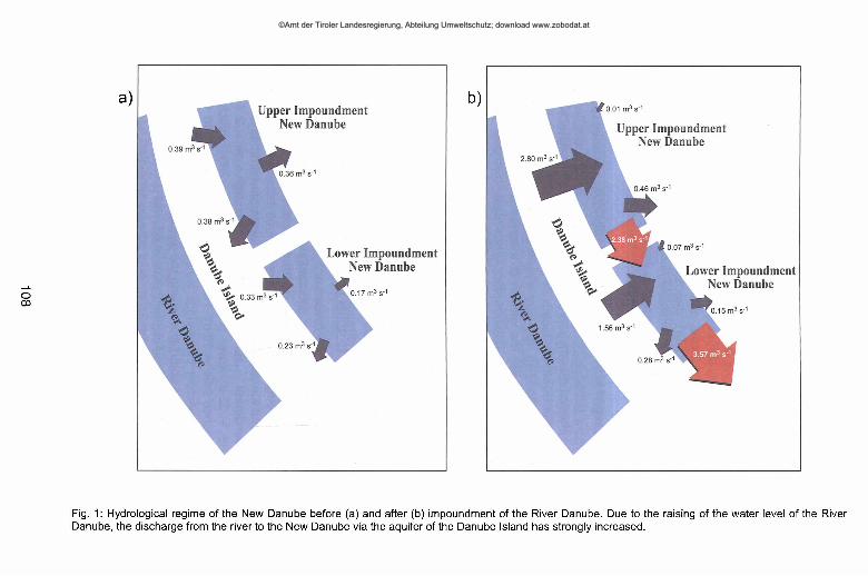
After 1996, construction of the Freudenau hydroelectric power station raised the level of the River Danube and substantially increased the hydraulic flow of water and nutrients into the New Danube. As a main consequence, the mean discharge through the aquifer of the Danube Island substantially increased (Fig. 1), and the residence time of the two impoundments decreased (upper impoundment summer 2001: discharge = 2.7 m3s '1,residence time = 32 d; lower impoundment summer 2001: discharge =3.6 m3 s”1, residence time = 19 d). The high water supply opened new opportunities for connecting the various water bodies on the left side of the Danube (Old Danube, Lobau) and raising the groundwater level in the Lobau area. Also in the New Danube, the water level was raised. Furthermore, seasonal fluctuations of the water level could now be simulated according to records of the natural fluctuations of the River Danube by the so called "Musterganglinie”, which was derived from daily water level measurements during 1970-1993 (Schiel 1999).
107
©Amt der Tiroler Landesregierung, Abteilung Umweltschutz; download www.zobodat.at
108
Fig. 1: Hydrological regime of the New Danube before (a) and after (b) impoundment of the River Danube. Due to the raising of the water level of the River Danube, the discharge from the river to the New Danube via the aquifer of the Danube Island has strongly increased.
©Amt der Tiroler Landesregierung, Abteilung Umweltschutz; download www.zobodat.at
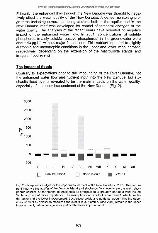
Primarily, the enhanced flow through the New Danube was thought to negatively affect the water quality of the New Danube. A dense monitoring programme including several sampling stations both in the aquifer and in the New Danube itself was developed for control of temporal changes of the water quality. The analyses of the recent years have revealed no negative impact of the enhanced water flow. In 2001, concentrations of soluble phosphorus (mainly soluble reactive phosphorus) in the groundwater were about 40 pg L~1 without major fluctuations. This nutrient input led to slightly eutrophic and mesotrophic conditions in the upper and lower impoundment, respectively, depending on the extension of the macrophyte stands and irregular flood events.
The impact of floods
Contrary to expectations prior to the impounding of the River Danube, not the enhanced water flow and nutrient input into the New Danube, but stochastic flood events revealed to be the main impacts on the water quality, especially of the upper impoundment of the New Danube (Fig. 2).
3000
2500
2000
O. 1500 l-G>
- * 1000
500
0
-500
| | Danube Island Q flood events [ J W e ir 1
Fig. 2: Phosphorus budget for the upper impoundment of the New Danube in 2001. The permanent input via the aquifer of the Danube Island and stochastic flood events are the main phosphorus sources. Other nutrient sources such as precipitation or groundwater input from the left "hinterland” are of minor importance. The main phosphorus output is over weir 1, which divides the upper and the lower impoundment. Suspended solids and nutrients brought into the upper impoundment by smaller to medium flood events (e.g. March & June 2001) remain in the upper impoundment, but do not significantly affect the lower impoundment.
109
©Amt der Tiroler Landesregierung, Abteilung Umweltschutz; download www.zobodat.at
The effects of floods on the New Danube are manifold: Smaller flood events bring a big amount of suspended solids and nutrients into the upper impoundment. The fine particles are deposited on the sediment, but are easily eroded and stirred up again by wind induced waves, unless macrophytes stablise the water body and reduce turbulence. In areas without macrophyte stands (actually mainly in the upper impoundment), planktonic algae readily use the nutrient supply provided by floods, leading to enhanced chlorophyll-a concentrations and reduced transparency. When larger floods are drained through the New Danube, fine sediments, which have been accumulated up to then, are eroded (in some areas down to the bare gravel) and washed out to the main river. During the vegetation season this "flushing effect” of high floods may also directly affect the submerged macrophytes by pulling them out. (Most macrophyte species inhabiting the New Danube cannot withstand high current velocities).
Future perspectives
Extensive chemical and biological investigations carried out during the last years showed no significant negative impact of the impoundment of the River Danube on the water quality of the New Danube. As the nutrient concentrations of the permanent groundwater inflow as well as the clogging up of the aquifer have reached a rather stable level, also the water quality of the New Danube is expected to remain stable, viz. meso- to eutrophic (depending on the development of macrophyte stands). Dramatic and short term changes of the water quality might, however, occur as a result of stochastic flood events. Flood protection for the city of Vienna is the main function of the New Danube. Thus, the opportunities to preserve the good water quality of the New Danube during flood events are rather limited. At present, hydro- logical studies prove the possibility to elevate the inlet weir in order to prevent "small” floods from penetrating into the upper impoundment of the New Danube. A more flexible handling of the water level regulation immediately after strong floods could be another way to reduce nutrient inputs into the New Danube. Both measures should help to ensure good water quality suitable for bathing, irrigation purposes and also for regulating groundwater levels in the important wetland areas of the "hinterland” on the left-bank of the New Danube.
ReferencesSchiel, W. (ed., 1999). 10 Jahre Gewässergüteforschung Neue Donau. Perspektiven 2-3/1999,
18-96.Sutcliffe, D.W. (ed., 2000). Managing the New Danube in Vienna (Austria): the importance of
plant nutrients and aquatic macrophytes. Arch. Hydrobiol. Suppl. 135, Large Rivers 12, 1- 103.
Wolfram, G., U.H. Humpesch & A. Dujmic (eds, 2001). Neue Donau 2000: Kolmation. Gutachten im Auftrag der Stadt Wien, MA 45, Wien, 210 pp.
Wolfram, G. & U.H. Humpesch (eds, 2002). Neue Donau 2001: Hochwasser und Aquifer: Eutrophierende Wirkung auf die Neue Donau. Gutachten im Auftrag der Stadt Wien, MA 45, Wien, 203 pp.
110
©Amt der Tiroler Landesregierung, Abteilung Umweltschutz; download www.zobodat.at