THE IMPLICATION OF ANCIENT VOLCANO FOR … · Naming of Geomorphology Unit using naming based on...
6
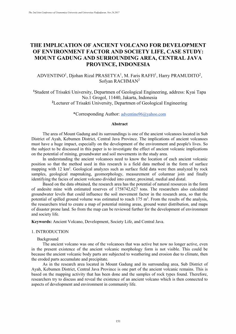
THE IMPLICATION OF ANCIENT VOLCANO FOR DEVELOPMENT OF ENVIRONMENT FACTOR AND SOCIETY LIFE, CASE STUDY: MOUNT GADUNG AND SURROUNDING AREA, CENTRAL JAVA PROVINCE, INDONESIA ADVENTINO 1 , Djohan Rizal PRASETYA 1 , M. Faris RAFFI 1 , Harry PRAMUDITO 2 , Sofyan RACHMAN 2 1 Student of Trisakti University, Departmen of Geological Engineering, address: Kyai Tapa No.1 Grogol, 11440, Jakarta, Indonesia 2 Lecturer of Trisakti University, Departmen of Geological Engineering *Corresponding Author: [email protected] Abstract The area of Mount Gadung and its surroundings is one of the ancient volcanoes located in Sub District of Ayah, Kebumen District, Central Java Province. The implications of ancient volcanoes must have a huge impact, especially on the development of the environment and people's lives. So the subject to be discussed in this paper is to investigate the effect of ancient volcanic implications on the potential of mining, groundwater and soil movements in the study area. In understanding the ancient volcanoes need to know the location of each ancient volcanic position so that the method used in this research is a field data method in the form of surface mapping with 12 km 2 . Geological analyzes such as surface field data were then analyzed by rock samples, geological mapmaking, geomorphology, measurement of columnar join and finally identifying the facies of ancient volcano divided into center, proximal, medial and distal. Based on the data obtained, the research area has the potential of natural resources in the form of andesite mine with estimated reserves of 1758742,627 tons. The researchers also calculated groundwater levels that could influence the soil movement factor in the research area, so that the potential of spilled ground volume was estimated to reach 175 m 3 . From the results of the analysis, the researchers tried to create a map of potential mining areas, ground water distribution, and maps of disaster prone land. So from the map can be reviewed further for the development of environment and society life. Keywords: Ancient Volcano, Development, Society Life, and Central Java. 1. INTRODUCTION Background The ancient volcano was one of the volcanoes that was active but now no longer active, even in the present existence of the ancient volcanic morphology form is not visible. This could be because the ancient volcanic body parts are subjected to weathering and erosion due to climate, then the eroded parts accumulate and precipitate. As in the research area located in Mount Gadung and its surrounding area, Sub District of Ayah, Kebumen District, Central Java Province is one part of the ancient volcanic remains. This is based on the mapping activity that has been done and the samples of rock types found. Therefore, researchers try to discuss and reveal the existence of an ancient volcano which is then connected to aspects of development and environment in community life. The 2nd Join Conference of Utsunomiya University and Universitas Padjadjaran, Nov.24,2017 151
Transcript of THE IMPLICATION OF ANCIENT VOLCANO FOR … · Naming of Geomorphology Unit using naming based on...
THE IMPLICATION OF ANCIENT VOLCANO FOR DEVELOPMENT OF ENVIRONMENT FACTOR AND SOCIETY LIFE, CASE STUDY: MOUNT GADUNG AND SURROUNDING AREA, CENTRAL JAVA
PROVINCE, INDONESIA
ADVENTINO1, Djohan Rizal PRASETYA1, M. Faris RAFFI1, Harry PRAMUDITO2, Sofyan RACHMAN2
1Student of Trisakti University, Departmen of Geological Engineering, address: Kyai Tapa No.1 Grogol, 11440, Jakarta, Indonesia
2Lecturer of Trisakti University, Departmen of Geological Engineering
*Corresponding Author: [email protected]
Abstract
The area of Mount Gadung and its surroundings is one of the ancient volcanoes located in Sub District of Ayah, Kebumen District, Central Java Province. The implications of ancient volcanoes must have a huge impact, especially on the development of the environment and people's lives. So the subject to be discussed in this paper is to investigate the effect of ancient volcanic implications on the potential of mining, groundwater and soil movements in the study area.
In understanding the ancient volcanoes need to know the location of each ancient volcanic position so that the method used in this research is a field data method in the form of surface mapping with 12 km2. Geological analyzes such as surface field data were then analyzed by rock samples, geological mapmaking, geomorphology, measurement of columnar join and finally identifying the facies of ancient volcano divided into center, proximal, medial and distal.
Based on the data obtained, the research area has the potential of natural resources in the form of andesite mine with estimated reserves of 1758742,627 tons. The researchers also calculated groundwater levels that could influence the soil movement factor in the research area, so that the potential of spilled ground volume was estimated to reach 175 m3. From the results of the analysis, the researchers tried to create a map of potential mining areas, ground water distribution, and maps of disaster prone land. So from the map can be reviewed further for the development of environment and society life.
Keywords: Ancient Volcano, Development, Society Life, and Central Java.
1. INTRODUCTION
BackgroundThe ancient volcano was one of the volcanoes that was active but now no longer active, even
in the present existence of the ancient volcanic morphology form is not visible. This could be because the ancient volcanic body parts are subjected to weathering and erosion due to climate, then the eroded parts accumulate and precipitate.
As in the research area located in Mount Gadung and its surrounding area, Sub District of Ayah, Kebumen District, Central Java Province is one part of the ancient volcanic remains. This is based on the mapping activity that has been done and the samples of rock types found. Therefore, researchers try to discuss and reveal the existence of an ancient volcano which is then connected to aspects of development and environment in community life.
The 2nd Join Conference of Utsunomiya University and Universitas Padjadjaran, Nov.24,2017
151
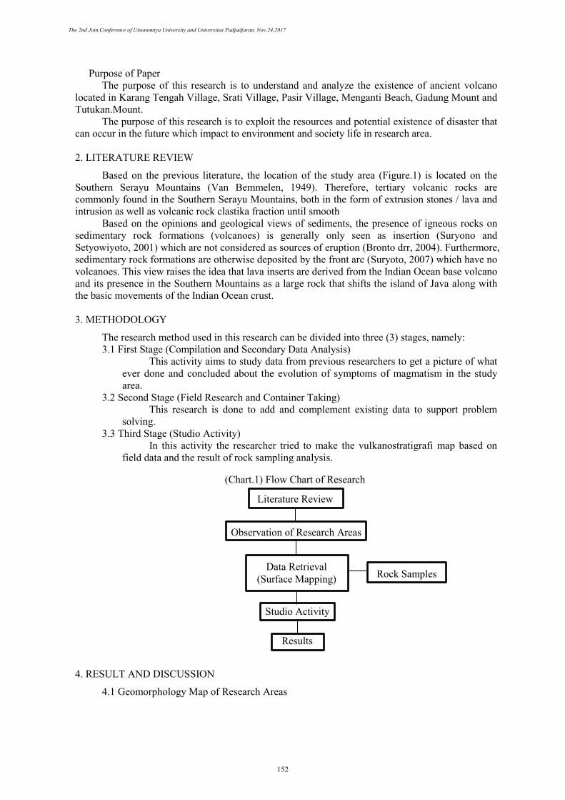
Purpose of Paper The purpose of this research is to understand and analyze the existence of ancient volcano
located in Karang Tengah Village, Srati Village, Pasir Village, Menganti Beach, Gadung Mount and Tutukan.Mount.
The purpose of this research is to exploit the resources and potential existence of disaster that can occur in the future which impact to environment and society life in research area.
2. LITERATURE REVIEW
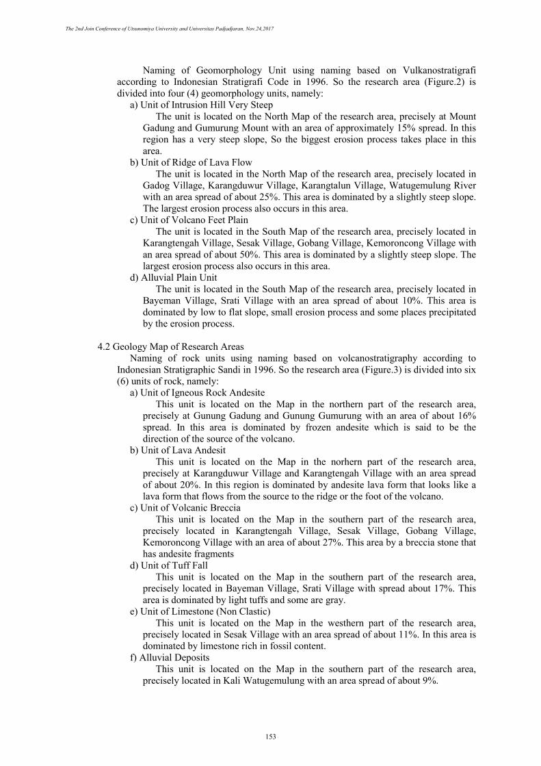
Based on the previous literature, the location of the study area (Figure.1) is located on the Southern Serayu Mountains (Van Bemmelen, 1949). Therefore, tertiary volcanic rocks are commonly found in the Southern Serayu Mountains, both in the form of extrusion stones / lava and intrusion as well as volcanic rock clastika fraction until smooth
Based on the opinions and geological views of sediments, the presence of igneous rocks on sedimentary rock formations (volcanoes) is generally only seen as insertion (Suryono and Setyowiyoto, 2001) which are not considered as sources of eruption (Bronto drr, 2004). Furthermore, sedimentary rock formations are otherwise deposited by the front arc (Suryoto, 2007) which have no volcanoes. This view raises the idea that lava inserts are derived from the Indian Ocean base volcano and its presence in the Southern Mountains as a large rock that shifts the island of Java along with the basic movements of the Indian Ocean crust.
3. METHODOLOGY
The research method used in this research can be divided into three (3) stages, namely: 3.1 First Stage (Compilation and Secondary Data Analysis)
This activity aims to study data from previous researchers to get a picture of what ever done and concluded about the evolution of symptoms of magmatism in the study area.
3.2 Second Stage (Field Research and Container Taking) This research is done to add and complement existing data to support problem
solving. 3.3 Third Stage (Studio Activity)
In this activity the researcher tried to make the vulkanostratigrafi map based on field data and the result of rock sampling analysis.
4. RESULT AND DISCUSSION
4.1 Geomorphology Map of Research Areas
Rock Samples
Results
Literature Review
Observation of Research Areas
Data Retrieval (Surface Mapping)
Studio Activity
(Chart.1) Flow Chart of Research
The 2nd Join Conference of Utsunomiya University and Universitas Padjadjaran, Nov.24,2017
152
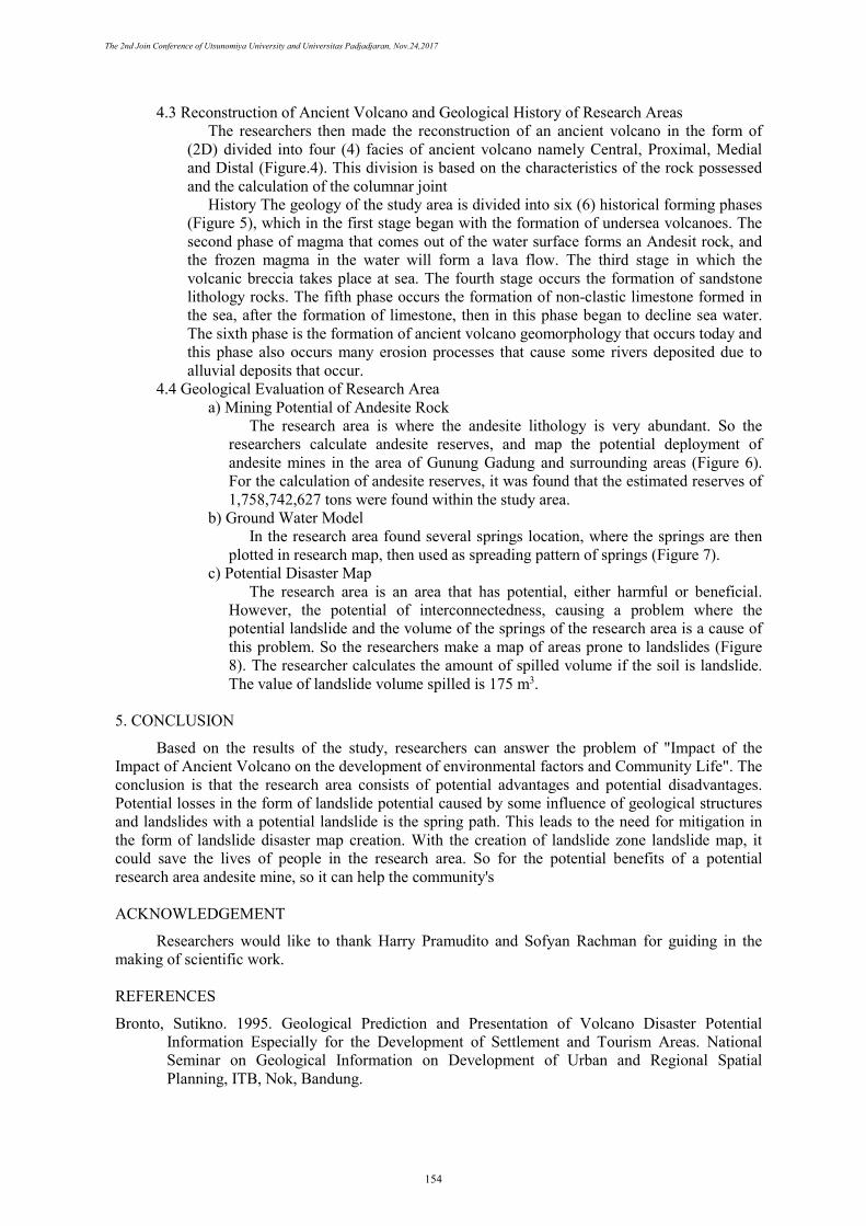
Naming of Geomorphology Unit using naming based on Vulkanostratigrafi according to Indonesian Stratigrafi Code in 1996. So the research area (Figure.2) is divided into four (4) geomorphology units, namely:
a) Unit of Intrusion Hill Very SteepThe unit is located on the North Map of the research area, precisely at Mount
Gadung and Gumurung Mount with an area of approximately 15% spread. In thisregion has a very steep slope, So the biggest erosion process takes place in thisarea.
b) Unit of Ridge of Lava FlowThe unit is located in the North Map of the research area, precisely located in
Gadog Village, Karangduwur Village, Karangtalun Village, Watugemulung Riverwith an area spread of about 25%. This area is dominated by a slightly steep slope.The largest erosion process also occurs in this area.
c) Unit of Volcano Feet PlainThe unit is located in the South Map of the research area, precisely located in
Karangtengah Village, Sesak Village, Gobang Village, Kemoroncong Village withan area spread of about 50%. This area is dominated by a slightly steep slope. Thelargest erosion process also occurs in this area.
d) Alluvial Plain UnitThe unit is located in the South Map of the research area, precisely located in
Bayeman Village, Srati Village with an area spread of about 10%. This area isdominated by low to flat slope, small erosion process and some places precipitatedby the erosion process.
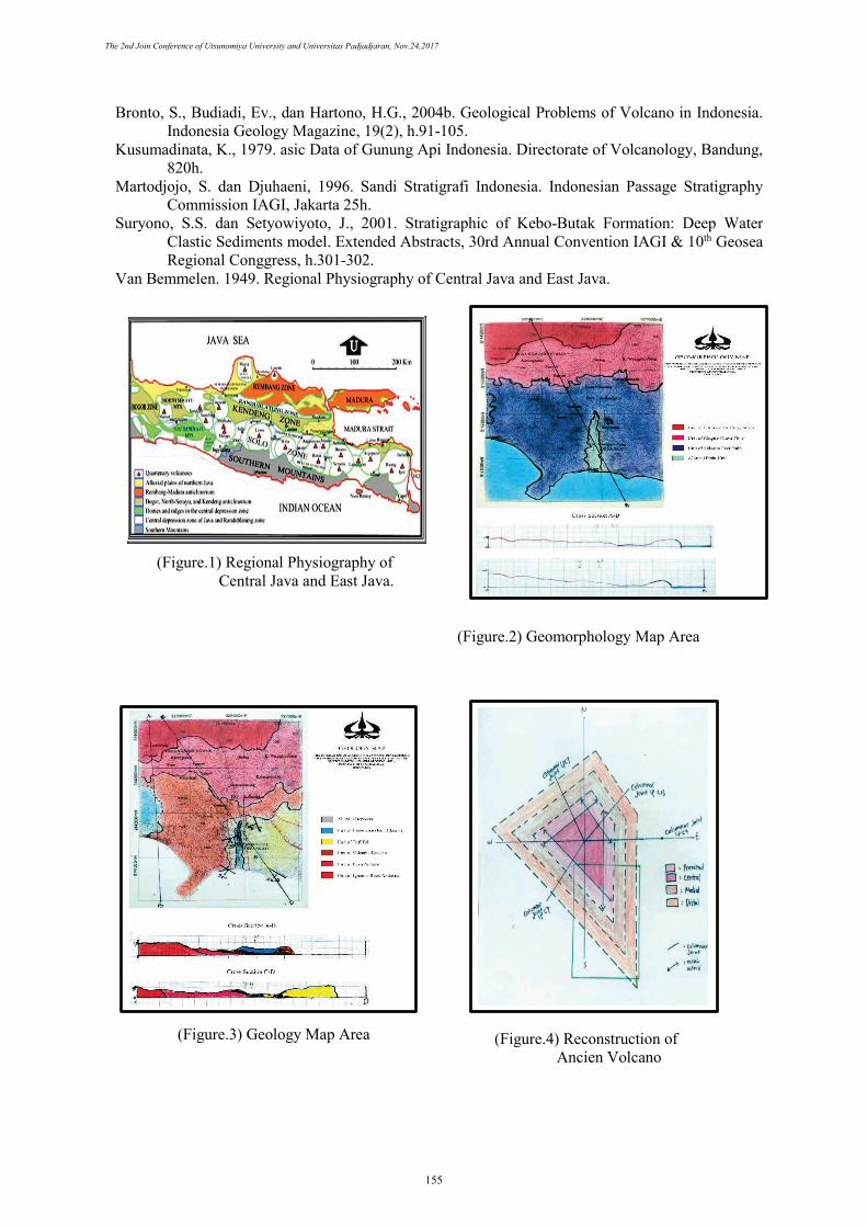
4.2 Geology Map of Research Areas Naming of rock units using naming based on volcanostratigraphy according to
Indonesian Stratigraphic Sandi in 1996. So the research area (Figure.3) is divided into six (6) units of rock, namely:
a) Unit of Igneous Rock AndesiteThis unit is located on the Map in the northern part of the research area,
precisely at Gunung Gadung and Gunung Gumurung with an area of about 16%spread. In this area is dominated by frozen andesite which is said to be thedirection of the source of the volcano.
b) Unit of Lava AndesitThis unit is located on the Map in the norhern part of the research area,
precisely at Karangduwur Village and Karangtengah Village with an area spreadof about 20%. In this region is dominated by andesite lava form that looks like alava form that flows from the source to the ridge or the foot of the volcano.
c) Unit of Volcanic BrecciaThis unit is located on the Map in the southern part of the research area,
precisely located in Karangtengah Village, Sesak Village, Gobang Village,Kemoroncong Village with an area of about 27%. This area by a breccia stone thathas andesite fragments
d) Unit of Tuff FallThis unit is located on the Map in the southern part of the research area,
precisely located in Bayeman Village, Srati Village with spread about 17%. Thisarea is dominated by light tuffs and some are gray.
e) Unit of Limestone (Non Clastic)This unit is located on the Map in the westhern part of the research area,
precisely located in Sesak Village with an area spread of about 11%. In this area isdominated by limestone rich in fossil content.
f) Alluvial DepositsThis unit is located on the Map in the southern part of the research area,
precisely located in Kali Watugemulung with an area spread of about 9%.
The 2nd Join Conference of Utsunomiya University and Universitas Padjadjaran, Nov.24,2017
153
4.3 Reconstruction of Ancient Volcano and Geological History of Research Areas The researchers then made the reconstruction of an ancient volcano in the form of
(2D) divided into four (4) facies of ancient volcano namely Central, Proximal, Medial and Distal (Figure.4). This division is based on the characteristics of the rock possessed and the calculation of the columnar joint
History The geology of the study area is divided into six (6) historical forming phases (Figure 5), which in the first stage began with the formation of undersea volcanoes. The second phase of magma that comes out of the water surface forms an Andesit rock, and the frozen magma in the water will form a lava flow. The third stage in which the volcanic breccia takes place at sea. The fourth stage occurs the formation of sandstone lithology rocks. The fifth phase occurs the formation of non-clastic limestone formed in the sea, after the formation of limestone, then in this phase began to decline sea water. The sixth phase is the formation of ancient volcano geomorphology that occurs today and this phase also occurs many erosion processes that cause some rivers deposited due to alluvial deposits that occur.
4.4 Geological Evaluation of Research Area a) Mining Potential of Andesite Rock
The research area is where the andesite lithology is very abundant. So theresearchers calculate andesite reserves, and map the potential deployment ofandesite mines in the area of Gunung Gadung and surrounding areas (Figure 6).For the calculation of andesite reserves, it was found that the estimated reserves of1,758,742,627 tons were found within the study area.
b) Ground Water ModelIn the research area found several springs location, where the springs are then
plotted in research map, then used as spreading pattern of springs (Figure 7). c) Potential Disaster Map
The research area is an area that has potential, either harmful or beneficial.However, the potential of interconnectedness, causing a problem where thepotential landslide and the volume of the springs of the research area is a cause ofthis problem. So the researchers make a map of areas prone to landslides (Figure8). The researcher calculates the amount of spilled volume if the soil is landslide.The value of landslide volume spilled is 175 m3.
5. CONCLUSION
Based on the results of the study, researchers can answer the problem of "Impact of the Impact of Ancient Volcano on the development of environmental factors and Community Life". The conclusion is that the research area consists of potential advantages and potential disadvantages. Potential losses in the form of landslide potential caused by some influence of geological structures and landslides with a potential landslide is the spring path. This leads to the need for mitigation in the form of landslide disaster map creation. With the creation of landslide zone landslide map, it could save the lives of people in the research area. So for the potential benefits of a potential research area andesite mine, so it can help the community's
ACKNOWLEDGEMENT
Researchers would like to thank Harry Pramudito and Sofyan Rachman for guiding in the making of scientific work.
REFERENCES
Bronto, Sutikno. 1995. Geological Prediction and Presentation of Volcano Disaster Potential Information Especially for the Development of Settlement and Tourism Areas. National Seminar on Geological Information on Development of Urban and Regional Spatial Planning, ITB, Nok, Bandung.
The 2nd Join Conference of Utsunomiya University and Universitas Padjadjaran, Nov.24,2017
154
Bronto, S., Budiadi, Ev., dan Hartono, H.G., 2004b. Geological Problems of Volcano in Indonesia. Indonesia Geology Magazine, 19(2), h.91-105.
Kusumadinata, K., 1979. asic Data of Gunung Api Indonesia. Directorate of Volcanology, Bandung, 820h.
Martodjojo, S. dan Djuhaeni, 1996. Sandi Stratigrafi Indonesia. Indonesian Passage Stratigraphy Commission IAGI, Jakarta 25h.
Suryono, S.S. dan Setyowiyoto, J., 2001. Stratigraphic of Kebo-Butak Formation: Deep Water Clastic Sediments model. Extended Abstracts, 30rd Annual Convention IAGI & 10th Geosea Regional Conggress, h.301-302.
Van Bemmelen. 1949. Regional Physiography of Central Java and East Java.
(Figure.1) Regional Physiography of Central Java and East Java.
(Figure.2) Geomorphology Map Area
(Figure.3) Geology Map Area (Figure.4) Reconstruction of Ancien Volcano
The 2nd Join Conference of Utsunomiya University and Universitas Padjadjaran, Nov.24,2017
155
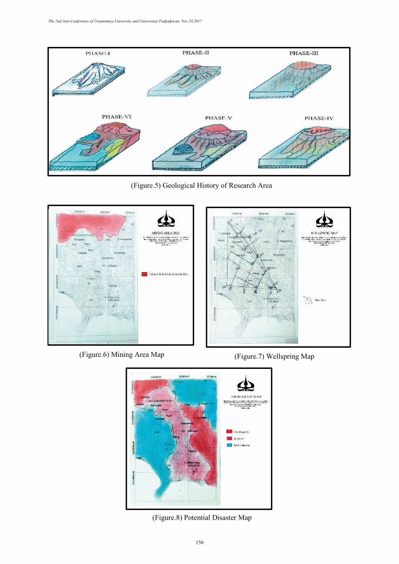
(Figure.5) Geological History of Research Area
(Figure.6) Mining Area Map
(Figure.7) Wellspring Map
(Figure.8) Potential Disaster Map
The 2nd Join Conference of Utsunomiya University and Universitas Padjadjaran, Nov.24,2017
156