Flood Plain Hydraulic Model Case Study: Poyo Creek ERANET-CRUE

_____________________________________________________________________________________________________ *Corresponding author: E-mail: [email protected];
Journal of Geography, Environment and Earth Science International 19(2): 1-10, 2019; Article no.JGEESI.47406 ISSN: 2454-7352
The Impact of Land Use Land Cover on the Flood Plain of Bhagirathi River, Purba Bardhaman District,
West Bengal, India
Sourav Misra1* and Tuhin Roy2
1Shibloon ACM High School, NET, WB SET, Purba Bardhaman-713140, India.
2Department of Geography, Sarojini Naidu College for Women, Kolkata-700028, India.
Authors’ contributions
This work was carried out in collaboration between both authors. Author SM designed the study,
performed the statistical calculation, and prepared all maps of the manuscript. Author TR managed the analyses of the study. Both authors read and approved the final manuscript
. Article Information
DOI: 10.9734/JGEESI/2019/v19i230079
Editor(s): (1) Dr. Pere Serra Ruiz, Department of Geography, Universitat Autònoma de Barcelona, Spain.
Reviewers: (1) Umo, Ikpong Sunday, Aivan Ikoku Federal College of Education, Nigeria.
(2) Ibrahim Sufiyan, Nasarawa State University Keffi, Nigeria. (3) R. Mahesh, Tamil University, India.
Complete Peer review History: http://www.sdiarticle3.com/review-history/47406
Received 17 November 2018 Accepted 18 February 2019 Published 21 February 2019
ABSTRACT
Aims: Human interference is the most important factor to change the LULC pattern over the earth surface. Land cover means to the physical parameters and land use means the cultural components. The present study associated with the changes in land uses a land cover pattern for the simultaneous changes of geomorphic features as well as the changes in the course of the river. This work is mainly going to summarize the changing behavior of land use land cover areas of a river bank in several decades. Place and duration of the Study: The research area traced in between 24°00’00’’N to 23°16’15’’N and 88°12’00’’E to 88°28’00’’E, which is situated in the eastern part of Purba Bardhaman District, West Bengal. Methodology: Entire study made by GIS techniques through the uses of topographical sheet (SOI-1960, Scale 1:50,000) and Satellite data (2002, 2008 & 2016). Through the help of superimposition technique the changes of river course have been identified which is directly affecting the LULC pattern of the entire flood plain.
Original Research Article

Misra and Roy; JGEESI, 19(2): 1-10, 2019; Article no.JGEESI.47406
2
Result: The study reveals that the entire area changes their LULC pattern which reflects the entire flood plain. Conclusion: Due to the high interference of human physical elements as well as water bodies, sand bar, fallow lands are being decreased in past decades, whereas settlement patches are continuously growing up. It means for the necessity of human livelihood human always have been modifying the land in different ways.
Keywords: Land use land cover; human interference; flood plain; river cut off; sedimentation;
morphometry etc.
1. INTRODUCTION The term Land Use and Land Cover shows two different directions, Land Use utilizes for the economic purposes and Land Cover indicates natural uses. In Geomorphology, various methods are used for LULC measurement. Due to the changing of geomorphic features on a large temporal scale, it also affects the uses of land utilization. Morphometrical changes are the most important aspect of geomorphological studies. It also affects the present land use and land cover changes in the present context. River discharge [1] condition may affect the change of morphometry, high-level discharge may affect the surrounding landform of the river bank, may influence the change of morphometric features.
1.1 Literature Review
Thornbury WD [2] mentioned in his book entitled, The Fundamental concept of Geomorphology, that is the geomorphic and tectonic process was active in all geological periods and their mode of operation was the same as today but the intensity of works differed temporally.
Knighton D [3] tried to describe on his book entitled, Fluvial Forms and Process, which the pattern of river flow may affect the morphological pattern of a river.
Sen PK.[1] mentioned in his book entitled, Geomorphological Analysis of Drainage Basin, river morphology totally controlled the condition of river discharge. It also affects the surrounding landform.
Gustausion M, kolstrup E. [4] analysis the geomorphological characteristics of a landscape in their paper which is, A new symbol and GIS-based detailed Geomorphological Mapping System Development: Renewal of A scientific discipline for understanding landscape development.
Constantine, Dunne, [5] as specified in his paper entitled, Meander cutoff and the
controls on the production of oxbow lakes, proposed that the sinuosity index of a river measured by the size of the distribution of Ox-Bow lake in a river flood plain.
Das B, Mondal M, Das A. [6] has stated on the paper entitled Hydrodynamic changes of river course of part of Bhagirathi – Hugli in Nadia District - A Geoinformatics appraisal, explain the river bank erosion with the help of RS and GIS techniques.
Mishra N, Khare D, Shukla R, Singh L. [7] has mentioned in their paper entitled, Change Detection of Land Use/Land Cover in Upper Ganga Canal Command, India, Using Arc-GIS Tools, that is the increases the human activities cause the dramatical changes of Land Use and Land Cover pattern of the upper part of the river which stimulates to reduce the green patches beside the river bank.
Das K, Adak K, Samanta K. [8] highlighted in their article entitled, Hydrodynamic changes of river course of part of Bhagirathi – Hugli in Nadia district - A Geoinformatics appraisal, has stated that erosional and depositional process may affect the river cliff and also forming slip of slope when the deposition occurs in the inner part of the river which affects the morphometric pattern of a river.
Maiti S, Ghorai D, Satpathy R, Bandyopadhyay J. [9] outlined in their paper entitled, Monitoring of Land Use and Land Cover Change Over the Years Due to River Course shifting; A Case Study on Ganga River Basin Near Malda District, West Bengal Using Geo-Informatics Techniques, is that changes in river courses deeply affected the land use land cover pattern. Anthropogenic factors are more effective to change the geomorphic features of the river.
Misra S. [10] has stated in his paper entitled, Changing Morphometry of Bhagirathi River: A Case Study of Eastern Part of Purba Bardhaman District, changes

Misra and Roy; JGEESI, 19(2): 1-10, 2019; Article no.JGEESI.47406
2
of morphometrical feature arouse to modification of Land Use and Land Cover pattern of the river bank which also affect the river bank area which is controlled through the process of erosion and deposition.
1.2 Objective The Present study will try to fulfill the following objectives:
i. To study the changes of geomorphic
features to assess the River behaviors. ii. To analysis the Land Use Land Cover
Change and its present effect on an active flood plain.
2. DATABASE AND RESEARCH
METHODOLOGY The same physical process and laws that operate today operated throughout Geological
time, although not necessarily always with the same intensity as now [2].
Entire analysis has been shaped on the basis of secondary data. Those data have been taken from various sources which are attached below. These paper aims to assess the changes of geomorphic features and the Land Use Land Cover Patterns also detect their effect on a flood plain.
All data are analyzed from scanned topographical sheet 1970 and from landsat ETM+ of 2002, 2008 LISS-III of 2016 (Table 1).
3. RESULTS AND DISCUSSION
3.1 Geomorphological Mapping
A Geomorphological Map helps to show the different elements over the earth surface. As the study area is associated with the alluvial flood plain, so the features mainly Swamp, Cutoff Meanders, Ox-Bow Lake, Marshy land, Meander Scrolls etc. already existed in it (Table 2).
Table 1. Data source used in the analysis
Source of Data Base Type of Data Base Remarks
Survey of India topographical sheet No.-(79A/1,79A/2,79A/5,79A/6,79A/7)
R.F:1:50000
Date-1970
Global Land Cover Facility (GLCF)
Enhanced Thematic Mapper
(Landsat Image)
Spatial Resolution 30 meter
United State of Geological Survey (USGS)
Advanced Spaceborne Thermal Emission and Reflection Radiometer (ASTER)
Spatial Resolution 30 meter
National Remote Sensing Centre (NRSC) Bhuvan Store
Linear Image Self Scanning (Resourcesat LISS-III)
Spatial Resolution 23.5 meter
In this work, the following remote sensing and GIS software are being used –Arc GIS-10.3 2. Q-GIS-3.4 3. Erdas Imagine–9.3 4. Map Info-7.0
Table 2. Temporally changes of geomorphic features
Sl. no.
Geomorphic features
Extension Source Year Remarks
1. River Meander 88.234-23.655 SOI topographical sheet
1970 The extension is Decimal Degrees Format
2. Marshy Land 88.431-23.371 SOI topographical sheet
1970
3. Cut of Meander 625645.379-2617495.556 Landsat ETM+ 2002 The extension is UTM Format
4. Ox Bow Lake 635502.202-2593419.054 Landsat ETM+ 2002
5. Non- Perennial River
613041.573-2623635.81 Landsat ETM+ 2002
* Prepared by author

Misra and Roy; JGEESI, 19(2): 1-10, 2019; Article no.JGEESI.47406
2
Fig. 1. Flow chart of methodology
Fig. 2. Geomorphic map of 1970
Fig. 3. Geomorphic map of 2002
Fig. 4. Changes of river courses in different years

Misra and Roy; JGEESI, 19(2): 1-10, 2019; Article no.JGEESI.47406
3
Fig. 5. Temporal changes of river courses
3.2 Rivers Course Change
This study was conducted along the river line track of the Bhagirathi, which are frequently changed. For this changing area is affected by floods, bank erosion, and sedimentation, it also changed the land use land cover pattern beside the river bank.
It is clear from the above diagram that the river has changed of its course temporarily and it also affects the area surrounding river banks. The grid area is 0.1 sq. km. which have been taken for minor measurement. Using Arc Gis software, the area of change of river course has been measured which shown in the following table (Table 3). The two Blocks namely Ketugram-II and Katwa was gain area due to river deposition which is included in the research work has gained area because of River Disposition from 1970 to 2016. On the other hand, the area of Purbasthali-I and Kanlna Block under flood plain decreased between 1970 and 2016 because of Rapid Sideward Erosion Bhagirathi.
3.3 Land Use and Land Cover Change
Generally, there have three types of technique for preparation Land Use & Land Cover map.
Analog Method, visual interpretation of LULC map.
Digital Technique, Classify tone or same colour spectral value by using the software.
On Screen Interpretation Technique, combination of visual and digital technique.
Land Use Land Cover change is one of the most important techniques to measure the way of land utilization. There have so many techniques to measure the way of land utilization.
In this study using the maximum likelihood technique to create an unsupervised classification. Here we calculate major LULC classes to delineate result of river shifting.
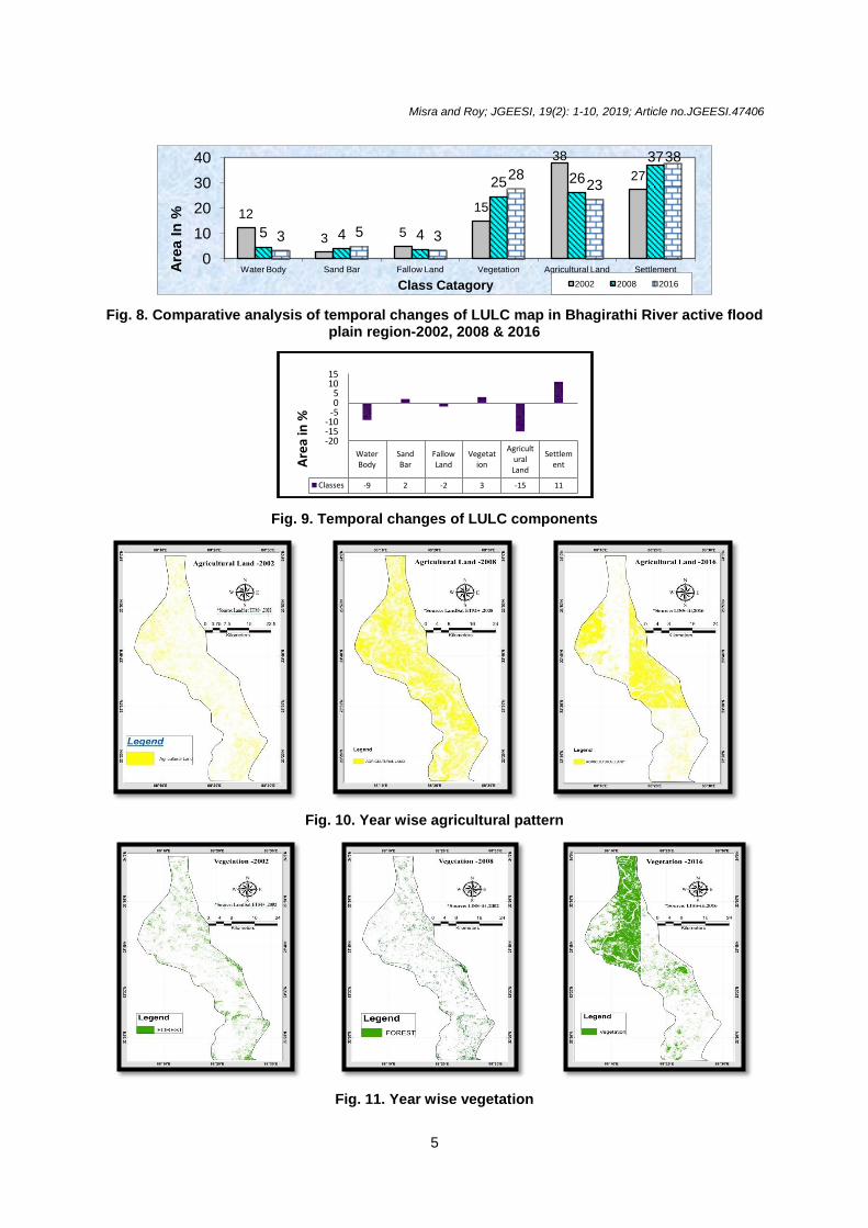
As per the above analysis among the major LULC components, its depict that from 2002 to 2016 water bodies and agricultural lands are being collapsed due to rapidly shifting of river and the other hand settlements are grown up through the touches of modernization, in the present context more or less 15% area of agricultural land mainly affected in Ketugram, Kalna and Katwa blocks. And also Waterbody, fallow land is decreasing near about 9% due to the huge amount of river shifting at Noyachor in Katwa Block and Pakir Chor in Purbasthali block and highly uses of land for development purpose. Whereas sand bar is increased for lack of water and a huge amount of sedimentation and vegetation are increased 3% due to tree plantation along the river bank in Ketugram and Katwa block for reducing the river bank erosion and settlement also being increased 11% due to the enhancement of growth of rapid population in Purbasthali and Kalna also for the uses of fertile land beside the river bank. For that reason, land use and land covers like vegetation, agricultural land, and settlements are affected too much, it means land covers are changed over the time period.

Misra and Roy; JGEESI, 19(2): 1-10, 2019; Article no.JGEESI.47406
4
Table 3. Quantitative measurement of changes of river course
Sl. no.
Location
Extension
Quantitative measurement of river course changed (Area in sq. km.)
1970 SOI topographical sheet
2016 Liss-III Image
1 Ketugram-II 88°5’12”E&23°14’8”N-88°5’12”E&23°42’42”N
4.65 5.559
2 Katwa 88°6’22”E&23°39’26”N-88°13’41”E-23°36’32”N
5.873 7.72
3 Purbasthali 88°12’42”E&23°35’22”N-88°21’1.44”E&23°15’10”N
27.431 25.854
4 Kalna 88°19’20”E&23°17’54”N-88°21’54”E&23°15’10”N
4.161 2.454
* Prepared by author
Fig. 6. Flow chart of image classification
Fig. 7. Year wise change of land use and land cover pattern of Bhagirathi River
Misra and Roy; JGEESI, 19(2): 1-10, 2019; Article no.JGEESI.47406
5
Fig. 8. Comparative analysis of temporal changes of LULC map in Bhagirathi River active flood plain region-2002, 2008 & 2016
Fig. 9. Temporal changes of LULC components
Fig. 10. Year wise agricultural pattern
Fig. 11. Year wise vegetation
12
3 5
15
38
27
5 4 4
25 26
37
3 5 3
28 23
38
0
10
20
30
40
Water Body Sand Bar Fallow Land Vegetation Agricultural Land Settlement Are
a I
n %
Class Catagory 2002 2008 2016
Water Body
Sand Bar
Fallow Land
Vegetation
Agricultural Land
Settlement
Classes -9 2 -2 3 -15 11
-20 -15 -10
-5 0 5
10 15
Are
a in
%

Misra and Roy; JGEESI, 19(2): 1-10, 2019; Article no.JGEESI.47406
6
Fig.12. Year wise settlement patches
Fig. 13. Temporal changes of agricultural pattern, vegetation & settlement
Photograph 1. Noyachor ox-bow lake used for fishing purposes
Photograph 2. Pakhir Chor in Purbasthali Block, use for a Tourist spot
It’s a characteristic of a perennial river is that one side destroyed and the other side is formatted. Like the river in the meandering stage so the riverside erosion continuously increased so that the land use land cover continuously changes
such as Ketugram losses 3.42 sq. km area whereas Purbasthali gain 22.23 sq. km. area due to the deposition of river eroded material. [10].

Misra and Roy; JGEESI, 19(2): 1-10, 2019; Article no.JGEESI.47406
7
4. CONCLUSION
The research work demonstrates the geomorphic changes as well as changes in the characteristics of the land. A major focus was made to appropriate classification of land which was change through the period. However, the river courses changes are noticeable due to the rapid growth of settlement from 2002-2016, whereas agricultural lands were decreased due to the changes or river courses and anthropogenic factors was played a vital role. The river cut off area is used as an agricultural land such as Noyachor, Kaligang, Pakhir Chor. The Bhagirathi River courses shifted simultaneously towards the east direction in between 1970-2016. So that’s why LULC pattern also being changed. River erosion is also increased which effect those areas which are situated beside the river so proper planning and management must be needed.
ACKNOWLEDGEMENTS
First of all, I would like to show my earnest gratitude and appreciation to my teacher and supervisor Dr. Tuhin Roy, Assistant Professor, Department of Geography, Sarojini Naidu College for Women through whom executing this work and writing this paper has become possible. His endless support from choosing this topic to prepare field work, dealing with GIS software, computer analysis etc. was invaluable assets for doing this work. I am also grateful to Nirmalya Mondal, Assistant Teacher of Shibloon ACM High School for his co-operation and ceaseless effort to fulfill my work. I also thank full to my friend Mr. Tanai Dutta who help me to complete the supervised classification survey. I covered my thanks to my student Ms. Piyali Ghatak for helping me to collect photos during this survey.
COMPETITING INTEREST
Authors have declared that no competing interests exist.
REFERENCES
1. Sen PK. Geomorphological analysis of drainage basins. The University of Burdwan. West Bengal; 1993.
2. Thornbury WD. Principles of Geomorphology. CBS Publisher. 2
nd Ed.
New Delhi; 2002. 3. Knighton D. Fluvial forms and process: A
new perspective, Edward Arnold. 1st Ed.
Australia. 1984;3145.
4. Gustausion M, kolstrup E. A new symbol and GIS-based detailed geomorphological mapping system development: Renewal of a scientific discipline for understanding landscape development. Elsevier; Geo-morphology. 2006;77(1-2):90-111. Accessed: 12/26/2018 Available:https://pure.uva.nl/ws/files/3804251/41638_Gustavvsson_et_al_Mapping_System.pdf
5. Constantine JA, Dunne T. Meander cutoff and the controls on the production of oxbow lakes. The Geological Society of America. 2008;36(1):23-26. Accessed: 12/26/2018 Available:https://www.researchgate.net/profile/Jose_Constantine/publication/249521157_Meander_cutoff_and_the_controls_on_the_production_of_oxbow_lakes/links/546494920cf2837efdb3dabf/Meander-cutoff-and-the-controls-on-the-production-of-oxbow-lakes.pdf?origin=publication_detail
6. Das B, Mondal M, Das A. Monitoring of bank line erosion of River Ganga, Malda District, and West Bengal: Using RS and GIS compiled with statistical techniques. International Journal of Geometrics and Geoscientists. 2012;3(1):23-248. Accessed: 12/26/2018 Available:http://www.ipublishing.co.in/jggsvol1no12010/volthree/EIJGGS3120.pdf
7. Mishra N, Khare D, Shukla R, Singh L. Change detection of land use/land cover in upper Ganga Canal Command, India, Using Arc-GIS Tools. Journal of Remote Sensing & GIS. 2013;4(3):26-32. Accessed: 12/26/2018 Available:https://www.researchgate.net/publication/279951291_Change_Detection_of_Land_UseLand_Cover_in_Upper_Ganga_Canal_Command_India_Using_Arc-GIS_Tools/download
8. Das K, Adak K, Samanta K. Hydrodynamic changes of river course of part of Bhagirathi – Hugli in Nadia District - A Geoinformatics appraisal. International Journal of Geomatics and Geosciences. 2014;5(2):43-56. Accessed: 12/26/2018 Available:http://www.ipublishing.co.in/jggsarticles/volfive/EIJGGS5024.pdf
9. Maiti S, Ghorai D, Satpathy R, Bandyopadhyay J. Monitoring of land use and land cover change over the years due to river course shifting; A case study on Ganga river basin near Malda District, West Bengal using geo-informatics

Misra and Roy; JGEESI, 19(2): 1-10, 2019; Article no.JGEESI.47406
8
techniques”. International Journal of Research in Advent Technology. 2014; 2(10):83-90. Accessed: 12/26/2018 Available:https://www.researchgate.net/publication/274315245_Monitoring_of_Land_Use_Land_Cover_Change_over_the_Years_Due_to_River_Course_Shifting_A_Case_Study_on_Ganga_River_Basin_near_Malda_District_West_Bengal_Using_Geo-informatices_Techniques/download
10. Misra S. Changing morphometry of Bhagirathi River; a case study of Eastern Part of Burdwan District. International Journal of Scientific Research and Review. 2018;7(8):493-502. Accessed: 12/26/2018 Available:http://www.dynamicpublisher.org/gallery/59-ijsrr-d758.pdf
________________________________________________________________________________ © 2019 Misra and Roy; This is an Open Access article distributed under the terms of the Creative Commons Attribution License (http://creativecommons.org/licenses/by/4.0), which permits unrestricted use, distribution, and reproduction in any medium, provided the original work is properly cited.
Peer-review history: The peer review history for this paper can be accessed here:
http://www.sdiarticle3.com/review-history/47406