THE ILLINOIS COMPREHENSIVE WILDLIFE CONSERVATION …...Table 3 260-261 II 315, 323, 327, 336 , 340...
380
State of Illinois Rod R. Blagojevich, Governor Department of Natural Resources Joel Brunsvold, Director THE ILLINOIS COMPREHENSIVE WILDLIFE CONSERVATION PLAN & STRATEGY VERSION 1.0 AS PRESCRIBED BY THE WILDLIFE CONSERVATION & RESTORATION PROGRAM AND STATE WILDLIFE GRANTS PROGRAM
Transcript of THE ILLINOIS COMPREHENSIVE WILDLIFE CONSERVATION …...Table 3 260-261 II 315, 323, 327, 336 , 340...

State of Illinois
Rod R. Blagojevich, Governor
Department of Natural Resources
Joel Brunsvold, Director
THE ILLINOIS COMPREHENSIVEWILDLIFE CONSERVATION
PLAN & STRATEGY
VERSION 1.0
AS PRESCRIBED BY THE WILDLIFE CONSERVATION & RESTORATION PROGRAM
AND STATE WILDLIFE GRANTS PROGRAM

ILLINOIS COMPREHENSIVE WILDLIFE CONSERVATION PLAN & STRATEGY Version 1.0i. Partners in Plan/Strategy Development
-i-
The Illinois Comprehensive Wildlife Conservation Plan & Strategy was
made possible with the help of these partners in conservation:
ABATE of Illinois, Inc.
Black Diamond Chapter
American Bird Conservancy
Association of Illinois Soil & Water
Conservation Districts
Audubon Chicago Region
Bird Conservation Network
Boone County Conservation District
Brookfield Zoo
Calhoun County Farm Bureau
Central Hardwoods Joint Venture
Central Illinois Musky Hunters
Champaign County Forest Preserve District
Chicago Botanic Garden
Chicago Wilderness
Cook County Forest Preserve District
Cosley Zoo
D.J. Case & Associates
Defenders of Wildlife
Ducks Unlimited
DuPage River Fly Tyers
Eastern Illinois University
Department of Biological Sciences
Educational Resources for Environmental
Sciences
Embarras Volunteer Stewards
Environmental Education Association of
Illinois
Environmental Law & Policy Center
Field Trial Clubs of Illinois
Fishing Buddies
Forest Preserve District of DuPage County
Forest Preserve District of Kane County
Forest Preserve District of Will County
Friends of Johnson Park
Grand Prairie Friends
Henson Robinson Zoo
Illinois Association of Conservation Districts
Illinois Association of REALTORS
Illinois Association of Regional Councils
Illinois Association of Resource
Conservation and Development Areas
Illinois Audubon Society
Illinois Conservation Foundation
Illinois Department of Agriculture
Division of Natural Resources
Illinois Department of Transportation
Design & Environment
Planning & Programming
Illinois Department of Natural Resources
C2000 Ecosystems Program
Endangered Species Task Group
Illinois Natural History Survey
Office of Land Management &
Education
Office of Law Enforcement

ILLINOIS COMPREHENSIVE WILDLIFE CONSERVATION PLAN & STRATEGY Version 1.0i. Partners in Plan/Strategy Development
-ii-
Illinois Department of Natural Resources
Office of Realty & Environmental
Planning
Office of Resource Conservation
Private Lands Task Group
Illinois Endangered Species Protection
Board
Illinois Environmental Protection Agency
Illinois Farm Bureau
Illinois Federation for Outdoor Resources
Illinois Forestry Development Council
Illinois-Indiana Sea Grant Program
Illinois Nature Preserves Commission
Illinois State Museum
Illinois State University
Department of Biological Sciences
International Association of Fish & Wildlife
Agencies
Izaak Walton League
Illinois Division
Champaign County Chapter
Jo Daviess Conservation Foundation
Kankakee County Soil & Water
Conservation District
Lake County Forest Preserve District
Lincoln Park Zoo
Little John Conservation Club
Macon County Conservation District
McHenry County Conservation District
National Wild Turkey Federation
Illinois Chapter
Northern Illinois Anglers Association
Northern Illinois Conservation Club
Organization of Wildlife Planners
Partners in Flight
Peggy Notebaert Nature Museum
Pheasants Forever
Prairie Rivers Network
Quail Unlimited
Rocky Mountain Elk Foundation
Sand Bluff Bird Observatory
Shawnee Audubon Society
Sierra Club
Illinois Chapter
Northwest Cook County Group
Shawnee Group
Southern Illinois University
Cooperative Wildlife Research
Laboratory
Southwestern Illinois RC & D
The Natural Lands Institute
The Nature Conservancy
The Ornithological Council
The Wildlife Society
Illinois Chapter
Tri-County Regional Planning Commission
Trout Unlimited
Illinois Council
Union County Farm Bureau
United Bowhunters of Illinois

ILLINOIS COMPREHENSIVE WILDLIFE CONSERVATION PLAN & STRATEGY Version 1.0i. Partners in Plan/Strategy Development
-iii-
University of Illinois at Urbana-Champaign
Department of Natural Resources &
Environmental Sciences
Urbana Park District
Upper Des Plaines River Ecosystem
Partnership
Upper Mississippi River and Great Lakes
Joint Venture
US Army Corps of Engineers
Rock Island District
St. Louis District
US Department of Agriculture
Farm Service Agency
Midewin National Tallgrass Prairie
Natural Resources Conservation
Service
Shawnee National Forest
US Fish & Wildlife Service
Region 3 Development Assistance
Team
Chicago Field Office
Illinois River National Fish & Wildlife
Refuges Complex
Mark Twain National Fish & Wildlife
Refuges Complex
National Acceptance Advisory Team
Rock Island Field Office
Upper Mississippi River National
Fish & Wildlife Refuges Complex
Western Illinois University
Department of Biological Sciences
Whiteside County Soil and Water
Conservation District
Will County Forest Preserve District
Winnebago County Forest Preserve District
Wisconsin Department of Natural
Resources
Special Thanks to the C2000 Ecosystem
Partnerships
AMERICAN BOTTOM
BIG RIVERS
CACHE RIVER
CARLYLE LAKE
DRIFTLESS AREA
DUPAGE RIVER COALITION
EMBARRAS RIVER
FOX RIVER
HEADWATERS
HEART OF THE SANGAMON
RIVER
ILLINOIS RIVER BLUFFS
KANKAKEE RIVER

ILLINOIS COMPREHENSIVE WILDLIFE CONSERVATION PLAN & STRATEGY Version 1.0i. Partners in Plan/Strategy Development
-iv-
C2000 Ecosystem Partnerships
KASKASKIA RIVER/SHOAL CREEK
KINKAID AREA WATERSHED
KISHWAUKEE RIVER
LAKE CALUMET
LA MOINE RIVER
LOWER DES PLAINES RIVER
LOWER KASKASKIA/SILVER
CREEK
LOWER ROCK RIVER
LOWER SANGAMON VALLEY
MACKINAW RIVER
MISSISSIPPI WESTERN FIVE
NORTH BRANCH OF THE
CHICAGO RIVER
OZARK
PRAIRIE PARKLANDS
ROCK RIVER
SALINE BASIN
SHAWNEE WATERSHED
SPOON RIVER
SUGAR-PECATONICA RIVERS
THORN CREEK MACROSITE
UPPER DES PLAINES RIVER
UPPER KASKASKIA RIVER
UPPER LITTLE WABASH
UPPER ROCK RIVER
UPPER SALT CREEK OF THE
SANGAMON
VERMILION RIVER
VERMILION WATERSHED TASK
FORCE

ILLINOIS COMPREHENSIVE WILDLIFE CONSERVATION PLAN & STRATEGY Version 1.0ii. Acknowledgments
-v-
ACKNOWLEDGMENTS
The Illinois Comprehensive Wildlife Conservation Plan & Strategy (Plan/Strategy) has
been made possible by tremendous cooperation and collaboration among many agencies,
organizations and individuals. All of the agencies and organizations participating in the
planning process are acknowledged on the previous pages. A number of excellent
conservation plans were consulted and incorporated into this document (Table 3). The
Plan/Strategy steering committee provided helpful guidance to the process (Table 2). Special
thanks to the scientists who contributed to status assessments, objectives, and natural division
assessments. The U.S. Fish & Wildlife Service was most helpful in guiding development of the
Plan/Strategy, and the International Association of Fish & Wildlife Agencies provided much-
appreciated support to Illinois and the other states.
Though the Illinois Comprehensive Wildlife Conservation Plan & Strategy documents
much work needs to be done, the accomplishments of yesterday’s and today’s conservationists
provide an excellent foundation for the future. Thanks to the Teaming With Wildlife Coalition,
the Wildlife Conservation & Restoration Program and State Wildlife Grants Program are
providing additional support to habitat and wildlife conservation. Development of the Illinois
Comprehensive Wildlife Conservation Plan & Strategy was supported by State Wildlife Grant
Program funding (Federal Aid Project T-2-P-1).

ILLINOIS COMPREHENSIVE WILDLIFE CONSERVATION PLAN & STRATEGY Version 1.0iii. Foreword
-vi-
FOREWORD
Illinois' Comprehensive Wildlife Conservation Plan is a truly historic effort; never before
has such a detailed, science-based plan for conserving our state's wildlife been undertaken.
This process stretched over several months, and involved professional wildlife biologists, and
also a knowledgeable steering committee representing several non-governmental wildlife and
conservation organizations. In addition, the draft plan was presented at a number of regional
meetings open to other interested groups and the general public, and was available to all on the
Illinois Department of Natural Resources website. Wildlife and habitat data from public and
private sources were evaluated and incorporated into the evolving plan.
Most importantly, the final plan presented here is one which involves action. It is not just
an inventory of species, but a plan to address the particular needs of wildlife that are declining
so that populations can be stabilized and then increased. Many conservation projects in the
past have been opportunistic and lacked a true sense of direction that could be plotted, tracked
and designated as successful. Long-range landscape-level planning is one important
component that leads to successful recovery efforts like those exemplified by wild turkeys and
waterfowl.
The Comprehensive Wildlife Conservation Plan is a way to make habitat management
and land protection targeted at ecosystems as exciting and successful as the aforementioned
restoration efforts. It will guide future conservation efforts by outlining specific areas where
limited dollars can be targeted to make positive impacts that are measurable.
At the same time, all those entities with a vested interest in conservation--who have
been part of the planning process--can work together more effectively in achieving the wildlife
habitat goals which have been identified. The strategies outlined herein will focus future action
by the Illinois Department of Natural Resources and many not-for-profit organizations which are
involved in saving, restoring and managing wildlife habitat. It will determine the best use of
State Wildlife Grants and should lead to additional future dollars for wildlife habitat conservation
in Illinois.

ILLINOIS COMPREHENSIVE WILDLIFE CONSERVATION PLAN & STRATEGY Version 1.0iii. Foreword
-vii-
Every state is currently involved in this same wildlife conservation planning process.
Grant programs are highly competitive, and additional federal revenues will depend on having
an outstanding national conservation plan. This effort is not about regulating land use, and is
not a new manual for protecting threatened and endangered species. It is a comprehensive
plan to manage public and private lands in the best way possible to benefit all Illinois wildlife,
and especially those with declining populations. This Comprehensive Wildlife Conservation
Plan is a blueprint for the future of successful wildlife management in Illinois.
Carl Becker John BurkIllinois Director of Conservation Programs Regional Wildlife BiologistThe Nature Conservancy National Wild Turkey Federation
Marilyn Campbell Eric SchenckExecutive Director Regional BiologistIllinois Audubon Society Ducks Unlimited
11 July 2005
Administrator
Placed Image
Administrator
Placed Image
Administrator
Placed Image
Administrator
Placed Image

ILLINOIS COMPREHENSIVE WILDLIFE CONSERVATION PLAN & STRATEGY Version 1.0iv. Guide to the Eight Required Elements in the Illinois Plan/Strategy
-viii-
iv. Guide to the Eight Required Elements in the Illinois Comprehensive Wildlife
Conservation Plan & Strategy for the National Acceptance Advisory Team
This section is provided for the National Acceptance Advisory Team (NAAT) to aid their
determination that the State of Illinois has satisfactorily addressed the eight congressionally
required elements of a comprehensive wildlife conservation plan & strategy. The National
Acceptance Advisory Team offered guidance to the states as to how the NAAT would
determine that each element had been addressed. Below, Illinois has considered each point of
the National Acceptance Advisory Team’s guidance, and indicated the sections, tables, figures,
and appendices of the Illinois Comprehensive Wildlife Conservation Plan & Strategy
(Plan/Strategy) most responsive to that guidance. Further, a brief narrative is provided under
each element, describing how that element is fulfilled within the Illinois Plan/Strategy.
Element 1: Information on the distribution and abundance of species of wildlife,
including low and declining populations as the state deems appropriate, that are
indicative of the diversity and health of the state’s wildlife:
NAAT Guidance Location in the Illinois Plan/Strategy...Section Page Table or
Figure
Page Appendix Page
A. The Strategy indicates sources of
information (e.g., literature, data bases,
agencies, individuals) on wildlife
abundance and distribution consulted
during the planning process.
II-C, D
VI
14-16
250-257
Table 3 260-261 II 315,
323,
327,
336,
340
B. The Strategy includes information
about both abundance and distribution
for species in all major groups to the
extent that data are available. There are
plans for acquiring information about
species for which adequate abundance
and/or dis tribution information is
unavailable.
III-F 100-106
Figs. 4-9 278-285 II
See also
add’l disk
310-343
C. The Strategy identifies low and
declining populations to the extent data
are available.
II-D
III-B
15-16
30-32
I
II
294-309
310-340

ILLINOIS COMPREHENSIVE WILDLIFE CONSERVATION PLAN & STRATEGY Version 1.0iv. Guide to the Eight Required Elements in the Illinois Plan/Strategy
-ix-
D. All major groups of wildlife have been
considered or an explanation is provided
as to why they were not (e.g., including
reference to implemented marine
fisheries m anagem ent plans). The State
may indicate whether these groups are
to be included in a future Strategy
revision.
II-D 15-16 I
II
294-309
310-340
E. The Strategy describes the process
used to select the species in greatest
need of conservation. The quantity of
information in the Strategy is determined
by the State with input from its partners,
based on what is available to the State.
II-D 15-16 Table 4 262 I 294
Biologists from several agencies and organizations reviewed eight criteria to identify
Illinois’ species in greatest need of conservation. The Endangered Species Technical Advisory
Committees were largely responsible for applying these criteria to their taxon of expertise
(invertebrates, fishes, amphibians and reptiles, birds, and mammals). [Endangered Species
Technical Advisory Committees are ad hoc subcommittees of the Illinois Endangered Species
Protection Board, and are composed of scientists drawn from several agencies, institutions and
universities.]
A large body of survey, research, collections and professional experience are available
for describing the distribution and abundance of Illinois’ Species in greatest need of
conservation, readily available to natural resource professionals, and too voluminous for
thorough inclusion. Examples of these sources of information for several taxa are provided in
Figures 4-9, and all available accounts for are species in greatest need of conservation are
provided on the supplemental disk. Species with poorly known status (distribution, abundance,
and/or population trend) are readily identified in the yellow and red “Status” columns (indicating
low and very low confidence) of Appendix II.
The Illinois plan/strategy acknowledges the selection criteria have been least-thoroughly
applied to invertebrates (with the possible exception of freshwater mussels), and augmenting
information on invertebrate species will be important for updates to the plan/strategy (Section II-
D, at pages 15-16)

ILLINOIS COMPREHENSIVE WILDLIFE CONSERVATION PLAN & STRATEGY Version 1.0iv. Guide to the Eight Required Elements in the Illinois Plan/Strategy
-x-
Element 2: Descriptions of locations and relative condition of key habitats and
community types essential to conservation of species identified in (1):
NAAT Guidance Location in the Illinois Plan/Strategy...Section Page Table or
Figure
Page Appendix Page
A. The Strategy provides a reasonable
explanation for the level of detail
provided; if insufficient, the Strategy
identifies the types of future actions that
will be taken to obtain the information.
II-D
III-F
16
111-118
Table 5 263-265 II 341-343
B. Key habitats and their relative
conditions are described in enough
detail such that the State can determine
where (i.e., in which regions,
watersheds, or landscapes within the
State) and what conservation actions
need to take place.
III-B
See also
Sect. IV
natural
division
accounts
36-39
119-246
Figs. 10,
12-16
286,
288-292
II 341-343
Three available tools and a new analysis were particularly powerful in describing the
location and relative condition of key habitats and community types:
1. The Illinois Land Cover, and its statistical summary based on satellite imagery from
1999-2000, identified the location and extent of many major habitat types. As
acknowledged in several places, this tool is not particularly useful in identifying
grassland habitat (i.e., much of the grassland in Illinois is heavily manicured and not
functional as habitat), or from differentiating savanna-type habitats from the partial
canopies of successional areas.
2. The Illinois Natural Areas Inventory is a 30-year effort to identify high-quality remnant
natural communities and grade them according to their ecological integrity. Far less
than 1% of Illinois qualifies as an Illinois Natural Areas Inventory site.
3. The Critical Trends Assessment Project periodically samples randomly-selected
forest, wetland, grassland and stream plots statewide for biological integrity. The

ILLINOIS COMPREHENSIVE WILDLIFE CONSERVATION PLAN & STRATEGY Version 1.0iv. Guide to the Eight Required Elements in the Illinois Plan/Strategy
-xi-
relative condition of habitats, among sites or regions of the state, and long term
changes, are being inferred from the Critical Trends Assessment Project.
4. Using available information, we identified the locations most important for conserving
Illinois’ species in greatest need of conservation, by considering the habitat associations
of forests, emergent vegetation wetlands, forested wetlands, grasslands, and streams
(see Figures H, I, J, K, L). Using a Geographic Information System, we ranked all
points in the state, for each habitat association, based on:
a. patch size
b. Illinois Natural Areas Inventory designation (high quality natural communities)
c. expected diversity of species in greatest need of conservation, based on GAP
Analysis hyperdistributions for terrestrial vertebrates, and fish and mussel
collections databases for streams
d. known presence of threatened and endangered species since 1995, as
recorded in the Illinois Department of Natural Resources Biotics 4 database.
Element 3: Descriptions of problems which may adversely affect species identified in (1)
or their habitats, and priority research and survey efforts needed to identify factors
which may assist in restoration and improved conservation of these species and
habitats:NAAT Guidance Location in the Illinois Plan/Strategy...
Section Page Table or
Figure
Page Appendix Page
A. The Strategy indicates sources of
information (e.g., literature, databases,
agencies, or ind ividuals) used to
determine the problems or threats.
II-C, D
VII
14-17
250-257
Table 3 260 II
315,
323,
327,
336,
340, 343
B. The threats/problems are described
in sufficient detail to develop focused
conservation actions (for example,
“increased highway mortalities” or “acid
mine dra inage” rather than generic
descriptions such as “development” or
“poor water quality”).
II-D
III-D
III-E
(“Issues”)
See also
Sect. IV
accounts
17
352-57
60, 66,
71, 77,
81, 84, 88
119-246
Table 6 266-267 II 310-343

ILLINOIS COMPREHENSIVE WILDLIFE CONSERVATION PLAN & STRATEGY Version 1.0iv. Guide to the Eight Required Elements in the Illinois Plan/Strategy
-xii-
C. The Strategy considers
threats/problem s, regardless of their
origins (local, State, regional, national
and international), where relevant to the
State’s species and habitats.
II-D
III-D
17
52-57
Table 4
Table 6
262
266-267
I
II
294-309
310-343
D. If available information is insufficient
to describe threats/problems, research
and survey efforts are identif ied to obtain
needed information.
II-D
III-D
III-F
17
52-57
100-118
II 310-343
E. The priority research and survey
needs, and resulting products, are
described sufficiently to allow for the
development of research and survey
projects after the Strategy is approved.
III-F 100-118
At the statewide scale, the Illinois plan/strategy considers twenty stresses, grouped into
the major classes of habitat, community, population, and direct human stresses. Each of these
stresses was ranked on its affects or potential affects on each of the mussel, fish, amphibian,
reptile, bird and mammal species in greatest need of conservation and habitat types.
Additionally, each stress score for each species and habitat is given a confidence indicator on
the quality of available information.
Sources of these stresses are highly variable among species and regions. Large-scale
sources of stress are indicated in the summary “Challenges for Wildlife & Habitat Resources”
(Sect. III-D). Sources of stress that are to be addressed by specific prioritized conservation
actions are also described in the “Issues” prefaces immediately before each of the seven
Campaigns outlined in “Priority Conservation Actions for Illinois Wildlife & Habitat Resources
(Sect. III-E). At smaller geographic scales, more refined perspectives on stresses and sources
of stress are outlined. These are presented under the heading of “Major Habitats & Challenges”
within the assessments of each of the fifteen natural divisions (Sect. IV).
Research and surveys essential to identifying problems, and developing effective
conservation actions, are outlined taxonomically, by habitat, and topically (e.g., invasive
species) (Sect III-F).

ILLINOIS COMPREHENSIVE WILDLIFE CONSERVATION PLAN & STRATEGY Version 1.0iv. Guide to the Eight Required Elements in the Illinois Plan/Strategy
-xiii-
Element 4: Descriptions of conservation actions determined to be necessary to conserve
the identified species and habitats and priorities for implementing such actions:
NAAT Guidance Location in the Illinois Plan/Strategy...Section Page Table or
Figure
Page Appendix Page
A. The Strategy identifies how
conservation actions address identified
threats to species of greatest
conservation need and their habitats.
III-E 59-91 III 344-353
B. The Strategy describes conservation
actions sufficiently to guide
implementation of those actions through
the development and execution of
specific projects and programs.
III-E 59-97 Table 8
Figs.
11-17
270-271
287-293
C. The Strategy links conservation
actions to objectives and indicators that
will facilitate monitoring and
performance m easurement of those
conservation actions (outlined in
Element #5).
III 344-353
D. The Strategy describes conservation
actions (where re levant to the State ’s
species and habitats) that could be
addressed by Federal agencies or
regional, national or international
partners and shared with other States.
III-E
See also
Sect. IV
accounts
59-97
119-246
Table 8
Figs.
11-17
270-271
287-293
E. If available information is insufficient
to describe needed conservation
actions, the Strategy identifies research
or survey needs for obtaining
information to develop specific
conservation actions.
III-E
III-F
59-91
100-118
F. The Strategy identifies the relative
priority of conservation actions.
III-E 59-97 Table 8
Figs.
11-17
270-271
287-293
The Illinois plan/strategy seeks to establish a common vision for wildlife and habitat
conservation in Illinois. Thus, Illinois developed objectives for the year 2025 (Sect. III-C:
“Desired Conditions for Illinois Wildlife & Habitat Resources”). When considered in the context
of problems affecting species and habitats (Sect III-D: “Challenges for Illinois Wildlife & Habitat

ILLINOIS COMPREHENSIVE WILDLIFE CONSERVATION PLAN & STRATEGY Version 1.0iv. Guide to the Eight Required Elements in the Illinois Plan/Strategy
-xiv-
Resources), identifying prioritized conservation actions was a more straightforward and rigorous
process.
Based on existing plans, workshops with conservation partners, and public comments,
conservation actions determined to be most feasible and most effective in reaching the State’s
wildlife and habitat objectives were compiled into seven overlapping statewide “campaigns:”
Streams, Forests, Farmland & Prairie, Wetlands, Exotic Species, Land & Water Stewardship,
and Green Cities (Sect III-E). Only the highest priority actions for achieving statewide
objectives are included in this section.
At the finer scale of the natural divisions, conservation actions are described for
addressing problems affecting species and habitats, and for implementation within
Conservation Opportunity Areas (locations identified by available data and conservation
partners as high importance for conserving species in greatest need of conservation).
Conservation actions applied at these smaller scales are necessary for achieving regional and
local conservation objectives, and contribute toward statewide goals.
Element 5: Proposed plans for monitoring species identified in (1) and their habitats, for
monitoring the effectiveness of the conservation actions proposed in (4), and for
adapting these conservation actions to respond appropriately to new information or
changing conditions:
NAAT Guidance Location in the Illinois Plan/Strategy...Section Page Table or
Figure
Page Appendix Page
A. The Strategy describes plans for
monitoring species identified in Element
#1, and their habitats.
II-E
III-F
20-21
100-118
B. The Strategy describes how the
outcomes of the conservation actions
will be monitored.
III-F 100-118 III 343-353
C. If monitoring is not identified for a
species or species group, the Strategy
explains why it is not appropriate,
necessary or possible.
III-F 100-111

ILLINOIS COMPREHENSIVE WILDLIFE CONSERVATION PLAN & STRATEGY Version 1.0iv. Guide to the Eight Required Elements in the Illinois Plan/Strategy
-xv-
D. Monitoring is to be accomplished at
one of several levels including individual
species, guilds, or natural communities.
III-F
See also
Sect. IV
accounts
100-118
119-246 III 344-353
E. The monitoring utilizes or builds on
existing monitoring and survey systems
or explains how information will be
obtained to determine the effectiveness
of conservation actions.
II-E
III-F
20-21
100-118
F. The monitoring considers the
appropriate geographic scale to evaluate
the status of species or species groups
and the effectiveness of conservation
actions.
III-F
See also
Sect. IV
accounts
100-118
119-246
III 344-353
G. The Strategy is adaptive in that it
allows for evaluating conservation
actions and implementing new actions
accordingly.
II-E
II-F
III-C
V
20-21
22-23
40
247
Table 9 272-273
Plans for monitoring species and habitats in the Illinois plan/strategy build upon
extensive, existing monitoring efforts. In several cases, specific protocols are available to begin
monitoring species or species groups that are not currently considered (e.g., calling frogs and
toads). In other cases, a need for monitoring is recognized, but techniques are not agreed
upon or feasible. For example, the ephemeral nature of migratory shorebirds and their habitat
challenges development of rigorous monitoring designs. Measuring demographic objectives,
such as source-sink status for patches of Neotropical migratory bird habitat, are prohibitively
expensive at large scales with current methods. Solutions are also described for habitats that
are insufficiently quantified, characterized and monitored (e.g., grassland, savanna/open
woodland, shrub-successional habitat) (Sect. III-F). For several species and communities with
highly restricted distributions in Illinois, monitoring is only appropriate at local or site scales.
Several such examples are found in the natural division accounts (Sect. IV), including annual
surveys of greater prairie-chickens, which currently only occur in two units of a single
conservation area, and the Northeastern Illinois Wetland Bird Survey that focuses on this
unique concentration of wetland sites.
The Illinois plan/strategy is intended to be a dynamic process that can be readily
updated as conditions change. We explicitly acknowledge that wildlife and habitat goals will

ILLINOIS COMPREHENSIVE WILDLIFE CONSERVATION PLAN & STRATEGY Version 1.0iv. Guide to the Eight Required Elements in the Illinois Plan/Strategy
-xvi-
change as implementation proceeds, natural resource conditions change, and social priorities
evolve (III-C at page 40), thus requiring a different set of conservation actions. Evaluating the
effectiveness of conservation actions, and modifying them as indicated, is scheduled as an
annual to biennial revision to the document; evaluating the status of species and habitats is to
be completed on a two- to five-year basis (see Table 9).
Element 6: Descriptions of procedures to review the Comprehensive Wildlife
Conservation Strategy at intervals not to exceed 10 years:
NAAT Guidance Location in the Illinois Plan/Strategy...Section Page Table or
Figure
Page Appendix Page
A. The State describes the process that
will be used to review the Strategy within
the next ten years.
II-F
V
22-23
247
Table 9
Table 10
272-273
274
The Illinois plan/strategy includes guidance on interim updates, and a formal 10-year
revision. Interim updates that are anticipated to be necessary at perpetual, annual to biennial,
and 2- to 5-year intervals are described (Table 9). Other unanticipated updates likely will also
be required. The process for formal 10-year revision is modeled on this initial development of
the document (see Table 10, including a proposed 24-month timeline). This process likely will
need to be modified to fit Illinois’ needs in 2015.
As the lead state natural resources agency, the Illinois Department of Natural
Resources is charged with maintaining the Illinois Plan/Strategy and leading the formal 10-year
revision process. The Department may elect to formally revise the entire document at any
earlier time, if warranted (Sect. V).
Element 7: Plans for coordinating, to the extent feasible, the development,
implementation, review, and revision of the Comprehensive Wildlife Conservation
Strategy with Federal, State, and local agencies and Indian tribes that manage significant
land and water areas within the state or administer programs that significantly affect the
conservation of identified species and habitats:

ILLINOIS COMPREHENSIVE WILDLIFE CONSERVATION PLAN & STRATEGY Version 1.0iv. Guide to the Eight Required Elements in the Illinois Plan/Strategy
-xvii-
NAAT Guidance Location in the Illinois Plan/Strategy...Section Page Table or
Figure
Page Appendix Page
A. The State describes the extent of its
coordination with and efforts to involve
Federal, State and local agencies, and
Indian Tribes in the development of its
Strategy.
I, ii, iii
I-C
II-B
II-C
II-D
III-C
i-vii
5-6
11-13
14
15-19
40
Table 3
Fig. 17
260
293
B. The State describes its continued
coordination with these agencies and
tribes in the implementation, review and
revision of its Strategy.
II-D
II-E
II-F
III-E
III-F
V
VI
See also
Sect. IV
15-19
20-21
22-23
59
98-99
247
248-249
119-246
**Please see narrative below for treatment of elements 7 and 8 in the Illinois plan/strategy.**
Element 8: Provisions to ensure public participation in the development, revision, and
implementation of projects and programs. Congress has affirmed that broad public
participation is an essential element of this process:
NAAT Guidance Location in the Illinois Plan/Strategy...Section Page Table or
Figure
Page Appendix Page
A. The State describes the extent of its
efforts to involve the public in the
development of its Strategy.
I, ii, iii
I-C
II-A
II-B
II-C
II-D
III-C
i-vii
5-6
9-10
11-13
14
15-19
40
Table 2
Table 3
Fig. 11
Fig. 17
259
260-261
287
293
B. The State describes its continued
public involvement in the implementation
and revision of its Strategy.
II-D
II-E
II-F
III-E
III-F
V
VI
See also
Sect. IV
15-19
20-21
22-23
59
98-99
247
248-249
119-246

ILLINOIS COMPREHENSIVE WILDLIFE CONSERVATION PLAN & STRATEGY Version 1.0iv. Guide to the Eight Required Elements in the Illinois Plan/Strategy
-xviii-
In development, review and revision of the Illinois plan/strategy, elements 7 and 8 were
broadly considered in combination, rather than separately, for practical reasons. In Illinois,
private organizations control significant land and water resources, and administer programs that
affect species in greatest need of conservation and their habitats, and thus fit the spirit of
element 7 even though they are not Federal, State, or local agencies. These groups also
represent very important segments of the public, in particular those who most highly value
wildlife and habitat resources for recreational and economic reasons. Involving
nongovernmental organizations and communicating through them was a key approach for
reaching the public in development and revision of the Illinois plan/strategy (element 8).
Successful implementation will require the cooperative efforts of many federal, state, and
agencies, partnerships, institutions, and nongovernmental organizations.
More than 150 federal, state, and local agencies, partnerships, institutions, and
nongovernmental organizations took part in development and revision of the Illinois
plan/strategy. About 350 agencies and organizations were sent letters, informing them of the
planning process and inviting their participation. Eventually, this developed into a list of about
350 persons who requested periodic updates on the planning process be sent to them via
email. Various announcements and updates were periodically published in the Illinois
Department of Natural Resources’ publications. Through presentations at meetings and
conferences (provided upon request), an estimated 600 persons were reached. In the autumn
of 2004, a series of eight planning workshops held statewide involved about 250
conservationists. Additionally, the Illinois Department of Natural Resources developed a
website to post information and updates on the planning process, documents (including draft
lists of the species in greatest need of conservation) for review and comment, a grant
application tool for competitive State Wildlife Grant Program funding, and opportunities for
involvement in the planning process (http://dnr.state.il.us/orc/wildliferesources/theplan/).
A partial draft of the Illinois plan/strategy was made available to all agencies,
organizations and the public for review and comment for 45 days in the winter of 2005. The
final draft document was available to all agencies, organizations and the public for review and

ILLINOIS COMPREHENSIVE WILDLIFE CONSERVATION PLAN & STRATEGY Version 1.0iv. Guide to the Eight Required Elements in the Illinois Plan/Strategy
-xix-
comment for 60 days in the spring of 2005. Both documents were posted on the website (URL
above), and provided free-of-charge, upon request, in hard copy and compact disc formats.

ILLINOIS COMPREHENSIVE WILDLIFE CONSERVATION PLAN & STRATEGY Version 1.0Index to the Illinois Plan & Strategy
-xx-
THE ILLINOIS COMPREHENSIVE WILDLIFE CONSERVATION PLAN & STRATEGY
Section Page
i. PARTNERS IN THE ILLINOIS COMPREHENSIVE WILDLIFE CONSERVATION
PLAN & STRATEGY DEVELOPMENT ............................................................................... i
ii. ACKNOWLEDGMENTS ..................................................................................................... v
iii. FOREWORD ............................................................................................................... vi
iv. GUIDE TO THE EIGHT REQUIRED ELEMENTS IN THE ILLINOIS COMPREHENSIVE
WILDLIFE CONSERVATION PLAN & STRATEGY FOR THE NATIONAL ACCEPTANCE
ADVISORY COMMITTEE .................................................................................................. viii
I. INTRODUCTION ................................................................................................................ 1
A. The Need for a Comprehensive Wildlife Conservation Plan/Strategy 3
B. Required Elements of a Comprehensive Wildlife Conservation Plan/Strategy 4
C. The Purpose of a Comprehensive Wildlife Conservation Plan/Strategy for Illinois 5
D. Assumptions 7
II. APPROACH & METHODS ......................................................................................... 9
A. Organizational Structure 9
B. Public & Partner Involvement 11
C. Other Planning Efforts Incorporated into the Comprehensive Wildlife
Conservation Plan/Strategy 14
D. Identifying Priorities, Problems & Actions 15
E. Monitoring & Adaptive Management 20
F. Plan Revision & Review 22
III. STATEWIDE OVERVIEW ....................................................................................... 24
A. Ecological Divisions of Illinois 24

ILLINOIS COMPREHENSIVE WILDLIFE CONSERVATION PLAN & STRATEGY Version 1.0Index to the Illinois Plan & Strategy
-xxi-
Section Page
B. Current Status of Illinois Wildlife & Habitat Resources 30
C. Desired Condition for Illinois Wildlife & Habitat Resources 40
D. Challenges for Illinois Wildlife & Habitat Resources 52
E. Priority Actions for Conserving Illinois Wildlife & Habitat Resources 59
Streams Campaign 60
Forests Campaign 66
Farmland & Prairies Campaign 71
Wetlands Campaign 77
Invasive Species Campaign 81
land & Water Stewardship Campaign 84
Green Cities Campaign 88
Priority Locations for Conserving Illinois’ Species in Greatest Need of
Conservation 92
F. Research, Monitoring & Evaluation 98
IV. NATURAL DIVISION ASSESSMENTS ......................................................................... 119
A. Coastal Plain 121
B. Grand Prairie 130
C. Illinois River and Mississippi River Sand Areas 141
D. Lake Michigan 147
E. Lower Mississippi River Bottomlands 153
F. Middle Mississippi Border 160
G. Northeastern Morainal 166
H. Ozark 178
I. Rock River Hill Country 189
J. Shawnee Hills 195
K. Southern Till Plain 203
L. Upper Mississippi River and Illinois River Bottomlands 213
M. Wabash Border 221
N. Western Forest-Prairie 231
O. Wisconsin Driftless 239

ILLINOIS COMPREHENSIVE WILDLIFE CONSERVATION PLAN & STRATEGY Version 1.0Index to the Illinois Plan & Strategy
-xxii-
Section Page
V. PLAN REVIEW & REVISION ..................................................................................... 247
VI. SUMMARY & BEGINNING IMPLEMENTATION .................................................. 248
VII. REFERENCES & RESOURCES ......................................................................... 250
VIII. TABLES ............................................................................................................ 258
Table 1. Executive Staff in the Illinois Department of Natural Resources Office
of Resource Conservation during the planning process 258
Table 2. Composition of the Illinois Comprehensive Wildlife Conservation Plan/
Strategy Steering Committee 259
Table 3. Plans used to develop the Illinois Comprehensive Wildlife Conservation
Plan/Strategy 260
Table 4. Criteria for Selecting Illinois’ Species in Greatest Need of Conservation 262
Table 5. Habitat categories and definitions used in the Illinois Comprehensive
Wildlife Conservation Plan/Strategy 263
Table 6. Stresses considered as potentially having adverse effects on Illinois’
Species in Greatest Need of Conservation 266
Table 7. Step-down of statewide habitat objectives to the natural division level 268
Table 8. Conservation Opportunity Areas 270

ILLINOIS COMPREHENSIVE WILDLIFE CONSERVATION PLAN & STRATEGY Version 1.0Index to the Illinois Plan & Strategy
-xxiii-
Section Page
Table 9. Expected updates to the Comprehensive Wildlife Conservation Plan
& Strategy, and their relative frequency 272
Table 10. Timeline and activities for 10-year revision to the Illinois Comprehensive
Wildlife Conservation Plan & Strategy 274
IX. FIGURES ............................................................................................................ 275
Fig. 1 The Nature Conservancy’s Ecoregions in Illinois 275
Fig. 2 The North American Bird Conservation Initiative’s Bird Conservation
Regions in Illinois 276
Fig. 3 The Natural Divisions of Illinois 277
Fig. 4 The information on distribution, abundance, habitat association, and
status available for the red-veined prairie leafhopper in Nyboer et al.
(2004). Similar accounts in this source are available for all of Illinois’
Threatened and Endangered Species. 278
Fig. 5 The information on distribution and abundance available for the ellipse, a
freshwater mussel, in the Illinois Natural History Survey’s mussel database.
Similar accounts in this source are available for all of Illinois’ Mussels in
Greatest Need of Conservation. 279
Fig. 6 The information on distribution and abundance available for the central
mudminnow, Umbra limi, in the Illinois Natural History Survey’s fish
collections database. Similar accounts in this source are available for all
of Illinois’ Fishes in Greatest Need of Conservation. 280

ILLINOIS COMPREHENSIVE WILDLIFE CONSERVATION PLAN & STRATEGY Version 1.0Index to the Illinois Plan & Strategy
-xxiv-
Section Page
Fig. 7 The information on distribution, abundance, habitat association, natural
history and status available for the crayfish frog in Phillips et al. (1999).
Similar accounts in this source are available for all of Illinois’ Amphibians
and Reptiles in Greatest Need of Conservation. 281
Fig. 8 The information on distribution, abundance, habitat association, and status
available for the bobolink in Kleen et al. (2004). Similar accounts in this
source are available for all of Illinois’ Birds in Greatest Need of Conservation
that nest within Illinois. 282
Fig. 9 The information on distribution of the least weasel from the Illinois GAP
Analysis Project (http://www.inhs.uiuc.edu/cwe/gap/). Similar maps from
this project are available for all of Illinois’ Amphibians, Reptiles, Birds and
Mammals in Greatest Need of Conservation. 285
Fig. 10 The Land Cover of Illinois, based on 1999-2000 imagery data (Luman et
al. 2004) 286
Fig. 11 Priority conservation areas identified by other conservation plans and
other known resource locations. 287
Fig. 12 Ranking of upland forest habitat for Illinois' Species in Greatest Need of
Conservation, based on forest size, diversity of Species in Greatest Need
of Conservation predicted from GAP Analysis, known locations of
endangered species, and Illinois Natural Areas Inventory forest
communities. 288
Fig. 13 Ranking of prairie areas for Illinois' Species in Greatest Need of Conservation,
based on diversity of Species in Greatest Need of Conservation predicted
from GAP Analysis, known locations of endangered species, railroad prairie
remnants and Illinois Natural Areas Inventory prairie communities. 289

ILLINOIS COMPREHENSIVE WILDLIFE CONSERVATION PLAN & STRATEGY Version 1.0Index to the Illinois Plan & Strategy
-xxv-
Section Page
Fig. 14 Ranking of forested wetland habitat (bottomland forest and swamp) for
Illinois' Species in Greatest Need of Conservation, based on wetland size,
diversity of Species in Greatest Need of Conservation predicted from GAP
Analysis, known locations of endangered species, and Illinois Natural
Areas Inventory forested wetland communities. 290
Fig. 15 Ranking of emergent and shallow water wetland habitat for Illinois'
Species in Greatest Need of Conservation, based on wetland size,
diversity of Species in Greatest Need of Conservation predicted from
GAP Analysis, known locations of endangered species, and Illinois
Natural Areas Inventory emergent wetland communities. 291
Fig. 16 Ranking of stream habitat for Illinois' Species in Greatest Need of
Conservation, based on diversity of fish and mussel Species in Greatest
Need of Conservation, known locations of endangered species, and Illinois
Natural Areas Inventory stream communities. 292
Fig. 17 Partner-selected priority areas for conserving Illinois' Species in Greatest
Need of Conservation, indicated by participants in planning workshops
in 2004. 293
X. APPENDICES ............................................................................................................ 294
Appendix I. Species in Greatest Need of Conservation for Illinois as identified by
eight criteria 294
Appendix II. Status, Objectives, and Stresses to Illinois’ Wildlife & Habitat
Resources 310
Appendix III. Stresses addressed, habitats improved, priority locations and
performance measures for key conservation actions 344

ILLINOIS COMPREHENSIVE WILDLIFE CONSERVATION PLAN & STRATEGY Version 1.0I. Introduction
-1-
I. INTRODUCTION
The Illinois Comprehensive Wildlife Conservation Plan/Strategy (or “Plan/Strategy”) has
been developed in cooperation with many agencies, organizations and individuals. As the State
of Illinois’ primary natural resources conservation agency, the Illinois Department of Natural
Resources accepted responsibility for developing and implementing, by 1 October 2005, a
comprehensive wildlife conservation plan/strategy as a condition of receiving Wildlife
Conservation and Restoration Program and State Wildlife Grant Program funding.
Within the Illinois Department of Natural Resources, The Office of Resource
Conservation is the unit directly charged with conservation of habitat, fisheries and wildlife.
Comprised of the Divisions of Habitat Resources, Fisheries, Wildlife Resources and the
Watershed Protection and Program Support Sections, the Office of Resource Conservation’s
vision, and primary challenges are:
Vision
Consistent with science-based natural resource management principles, to increase the
amount and quality of habitat available to support Illinois’ native plant and animal
species and other game species; promote their population viability, and regulate the
recreational, commercial, and scientific utilization of those species; to ensure their long-
term persistence and abundance and provide for their appreciation and enjoyment by
future generations of Illinoisans while also expanding the frontiers of natural resource
management.
Challenges
1. Increase the percentage of Illinois’ lands which are not plowed, paved, drained, or
landscaped.
2. Increase the quality of Illinois’ natural lands as measured by their ability to support
robust (abundance and richness) communities of native plants and animals.
3. Improve the capacities of Illinois’ agricultural and urban lands to support populations

ILLINOIS COMPREHENSIVE WILDLIFE CONSERVATION PLAN & STRATEGY Version 1.0I. Introduction
-2-
of native fish and wildlife. Increase access to Illinois’ lands and waters for outdoor
recreation purposes.
4. Meet or exceed recreational and commercial demands upon Illinois’ plant and animal
populations.
5. Restore populations of plant and animal species that have become rare or are
declining.
6. Eradicate, control, and prevent the introduction of invasive exotic species.

ILLINOIS COMPREHENSIVE WILDLIFE CONSERVATION PLAN & STRATEGY Version 1.0I. Introduction
-3-
I. A. The Need for a Comprehensive Wildlife Conservation Plan/Strategy
The Illinois landscape has changed dramatically since the time of European settlement
with natural lands being manipulated and developed. Illinois has lost over 90% of its original
wetlands, 99.99% of its original prairie, and currently has 424 state and 24 federally listed
threatened and endangered species within it’s boundaries. Over the past 30 years, populations
of many wildlife species have fallen dramatically, and over the past decade, expenditures for
the recovery of federally endangered species have increased more than 600%.
To prevent the need for listing more species, reduce the need for costly recovery efforts,
and address a chronic shortage of funding for wildlife conservation efforts, the U. S. Congress
has responded with a number of federal aid programs. Two of those programs are the Wildlife
Conservation & Restoration Program and the State Wildlife Grant Program (also known as the
State & Tribal Wildlife Grant Program). Since 2001, Illinois has received more than $10 million
in federal aid for Illinois’ nongame wildlife through these two programs, in addition to the
continuing funding provided by fees and excise taxes derived from hunters and anglers. A
condition placed on the Wildlife Conservation & Restoration Program and the State Wildlife
Grant Program funding has been for each state to develop a comprehensive wildlife
conservation plan/strategy. With guidance from the U.S. Fish and Wildlife Service, The Illinois
Department of Natural Resources must begin implementation of the plan/strategy by October 1,
2005.

ILLINOIS COMPREHENSIVE WILDLIFE CONSERVATION PLAN & STRATEGY Version 1.0I. Introduction
-4-
I. B. Required Elements of a Comprehensive Wildlife Conservation Plan/Stratgy
Congress has identified eight required elements for each state’s Comprehensive Wildlife
Conservation Plan/Strategy through the Wildlife Conservation & Restoration Program and State
and Wildlife Grants Program legislation. Plans must identify and provide for:
(i) Information on the distribution and abundance of species of wildlife, including low and
declining populations as the State fish and wildlife agency deems appropriate, that are
indicative of the diversity and health of the State's wildlife;
(ii) Descriptions of locations and relative condition of key habitats and community types
essential to conservation of species identified in (i);
(iii) Descriptions of problems which may adversely affect species identified in (i) or their
habitats, and priority research and survey efforts needed to identify factors which may
assist in restoration and improved conservation of these species and habitats;
(iv) Descriptions of conservation actions proposed to conserve the identified species and
habitats and priorities for implementing such actions;
(v) Proposed plans for monitoring species identified in (i) and their habitats, for
monitoring the effectiveness of the conservation actions proposed in (iv), and for
adapting these conservation actions to respond appropriately to new information or
changing conditions;
(vi) Descriptions of procedures to review the State Comprehensive Wildlife
Conservation Plan/Strategy at intervals not to exceed ten years; and
(vii) Plans for coordinating the development, implementation, review, and revision of the
State Comprehensive Wildlife Conservation Plan/Strategy with Federal, State, and local
agencies and Indian tribes that manage significant land and water areas within the State
or administer programs that significantly affect the conservation of identified species and
habitats.
(viii) Provisions to ensure public participation in the development, revision, and
implementation of projects and programs.

ILLINOIS COMPREHENSIVE WILDLIFE CONSERVATION PLAN & STRATEGY Version 1.0I. Introduction
-5-
I. C. The Purpose of a Comprehensive Wildlife Conservation Plan/Strategy for Illinois
The Plan/Strategy identifies habitat areas that demonstrate the greatest conservation
need and potential, and establishes specific conservation goals for the enhancement and
protection of these sites. The plan identifies tools to achieve specific and broad conservation
goals. Monitoring wildlife responses through protocols described in the Plan/Strategy will
ensure conservation actions are contributing to natural resource goals. Through adaptive
management and a dynamic Plan/Strategy, new challenges and opportunities that arise will be
addressed quickly.
Well over 90% of Illinois is privately-owned, and recreational demands on public lands
are great and likely to increase. Wildlife and habitat objectives must be addressed in this
context, and the Plan/Strategy considers actions for both public and private lands. Similarly,
the Plan/Strategy attempts to integrate non-game and game management by focusing, as
possible, on habitat resources. Such a “comprehensive” approach promises the most benefit
for Illinois’ species in greatest need of conservation.
The Illinois Department of Natural Resources is statutorily responsible for protecting,
conserving and managing the State’s natural resources, though many other agencies and
organizations assist in this endeavor. Protection, conservation and management is on-going,
but implementation has been traditionally multi-focused. Illinois has been involved with several
large-scale landscape management efforts (e.g., Conservation 2000 Ecosystem Program,
Interagency Pilot Watershed Program, the Conservation Reserve Enhancement Program,
Acres for Wildlife, Illinois Forestry Development Act) as well as more geographically focused
efforts to document and describe our resources (e.g., Illinois Natural Areas Inventory, Resource
Rich Areas, Important Bird Areas). With the diversity of conservation goals and programs being
implemented by various agencies and organizations, it has become increasingly difficult for
conservationists to identify priorities, efficiently direct funding and staffing to address priorities,
and effectively evaluate the success of efforts.

ILLINOIS COMPREHENSIVE WILDLIFE CONSERVATION PLAN & STRATEGY Version 1.0I. Introduction
-6-
The Illinois Department of Natural Resources will use the Plan/Strategy in the selection
of projects and distribution of services. Besides fulfilling the legal requirements for receiving
federal aid funding under Wildlife Conservation and Restoration Program and State Wildlife
Grant Program, the Plan/Strategy will support future grants, direct habitat programs, guide the
management of Illinois Department of Natural Resources sites and land protection, and
facilitate partner projects with federal, local and not-for-profit conservation organizations and
private landowners. This plan will be useful for prioritizing allocations from the State Wildlife
Grants Program, Federal Aid in Sportfish and Wildlife Restoration, waterfowl stamp, habitat
stamp, furbearer fund, Wildlife Preservation Fund, C2000 Ecosystem Program, Natural Areas
Acquisition Fund, and other sources.
The Plan/Strategy and its implementation will be valuable to the Department of Natural
Resources' consultation program that assesses the impacts on State endangered species and
Natural Areas of actions authorized, funded or carried out by State agencies and local
government. In particular, the Plan/Strategy provides better information on the occurrence and
distribution of threatened and endangered species, on the habitats and community types that
are key to these species, and on the problems that may adversely affect them. The
Plan/Strategy can aid in developing recommendations to avoid, minimize, or compensate for
adverse impacts, through its descriptions of conservation actions that will conserve particular
threatened and endangered species and their habitats. The consultation program in turn will
demonstrate research priorities or needs for special surveys as a result of reviewing potential
development projects.

ILLINOIS COMPREHENSIVE WILDLIFE CONSERVATION PLAN & STRATEGY Version 1.0I. Introduction
-7-
I. D. Assumptions
Implicit in the Plan/Strategy are many important assumptions, including:
1. Resource needs and opportunities vary geographically and change over time. The
Plan/Strategy cannot be a document that prescribes conservation actions for all situations, but it
can be a process for making such decisions and provide a “big-picture” context that can guide
locally-led conservation.
2. Past and on-going conservation activities have been highly beneficial; without them, current
conditions would be poorer. However, important lessons can be drawn from past successes
and failures. As needs and priorities evolve, improvements to on-going programs will become
evident.
3. Resource opportunities vary by ownership of land and water resources. Private and public
areas each have important, but different, roles in habitat conservation.
4. Not all needs can be met simultaneously at one location, yet more needs and benefits may
be present at one location than are fully realized under existing management.
5. Every wildlife objective requires habitat of adequate extent and quality to be met.
6. Not every wildlife species or habitat has sufficient recognition or professional or popular
support base to be addressed. Indeed, biases in available information, participating expertise,
and past conservation planning are evident throughout this document (e.g., a vertebrate-bias in
the Species in Greatest Need of Conservation). Bias needs to be acknowledged, and then
accepted or minimized, when identifying priorities for “comprehensive” wildlife conservation.
7. Habitat conservation has benefits beyond wildlife. Wildlife habitat is complimentary with
agricultural sustainability, soil conservation, water and air quality, economic stability, public
health and safety, property values, and quality-of-life of Illinois’ citizens.

ILLINOIS COMPREHENSIVE WILDLIFE CONSERVATION PLAN & STRATEGY Version 1.0I. Introduction
-8-
8. It is not possible to fully distinguish between resource needs (based on factors such as
population size, trends and viability) and human needs (including funding sources and local
support). Resource needs reflect human desires for biodiversity, wildlife viewing/encounter
opportunities, harvest and other uses. Human needs reflect wildlife and habitat conditions that
people experience while forming expectations.
9. Conservation actions taken (or neglected) in other states, nations and continents will be
manifest in the wildlife and habitat conditions experienced in Illinois, and vice versa.
10. Wildlife is a resource held in public trust. Governmental agencies are mandated to
manage wildlife accordingly. Organizations and individuals engaged in habitat conservation are
working to fulfill individual goals, but the public is also a benefactor of those actions.

ILLINOIS COMPREHENSIVE WILDLIFE CONSERVATION PLAN & STRATEGY Version 1.0II. Approach & Methods
-9-
II. APPROACH & METHODS
II. A. Organizational Structure
To develop the Plan/Strategy, the Illinois Natural History Survey, a scientific branch of
the Illinois Department of Natural Resources, hired a Planning Coordinator to work closely with
the Department of Natural Resources’s Office of Resource Conservation. Direct oversight and
guidance of the Planning Coordinator was provided by Office of Resource Conservation
Executive Staff–division chiefs from Fisheries, Habitat Resources, Program Support,
Watershed Protection, and Wildlife Resources, and the Office of Resource Conservation Office
Director (Table 1).
A steering committee was formed, chaired by the Planning Coordinator, composed of
Department of Natural Resources staff from the Offices of Resource Conservation, Realty and
Environmental Planning, and Land Management and Education, and representatives from four
external not-for-profit partner organizations (Ducks Unlimited, Illinois Audubon Society, National
Wild Turkey Federation, and The Nature Conservancy; Table 2). The Office of Resource
Conservation invited these groups to serve on the steering committee, based upon several
factors, including: (1) a statewide presence of the groups, (2) a habitat-conservation mission,
(3) a balance of traditionally sporting and environmental organizations, (4) staffing levels within
the organization that would allow steering committee representatives to devote significant time
to the planning process, and (5) representatives that would be able to communicate with
diverse constituents on the planning process.
The purpose of the steering committee was to assist broadly in all aspects of
developing, reviewing, implementing, and updating the Plan/Strategy for Illinois. Specifically,
the committee guided the identification of conservation priority areas; information-sharing on
the distribution, abundance, and threats to conservation elements within Illinois; development of
conservation objectives and prioritization of conservation opportunity areas for management
intervention; and the proposal, design and implementation of conservation actions and
monitoring/evaluation protocols. Committee members assisted the Plan Coordinator in

ILLINOIS COMPREHENSIVE WILDLIFE CONSERVATION PLAN & STRATEGY Version 1.0II. Approach & Methods
-10-
communicating with partner agencies and organizations, and facilitated public participation in
the planning process through outreach to their constituents and broader audiences. The
steering committee met on six (6) occasions between February 2003 and May 2005, plus eight
(8) workshops for Department of Natural Resources staff and partner organizations in
September and October of 2004 (see below). It is anticipated that the steering committee will
be modified and expanded into a group providing broad oversight and coordination to
implementation, evaluation and revision of the Plan/Strategy.

ILLINOIS COMPREHENSIVE WILDLIFE CONSERVATION PLAN & STRATEGY Version 1.0II. Approach & Methods
-11-
II. B. Public & Partner Involvement
A concerted effort was made to inform and involve the public throughout the planning
process. D.J. Cases & Associates, with the Plan Coordinator, developed a strategy for public
participation that outlined the expected audiences, public involvement objectives for each
audience, and strategies for reaching those objectives (DJ Case & Assoc. 2004).
Print media - An article announcing the planning process appeared in the First Quarter
2004 issue of the newsletter “DNR Update,” and provided contact information for the Planning
Coordinator and a link to the Plan/Strategy website. The Spring/Summer issue of “The
Conservation Communicator” (a Department of Natural Resources newsletter for the C2000
Ecosystems Program, EcoWatch Network, Critical Trends Assessment Program, and Illinois
Natural Resources Information Network), discussed the planning process, introduced the
steering committee, presented the eight ‘required elements,’ and provided a link to the
Plan/Strategy website. In the November 2004 issue of Outdoor Illinois (the Department of
Natural Resources’ primary publication), the opening article from Director Joel Brunsvold
discussed the need for the Plan/Strategy, and encouraged readers to get involved by
commenting on the Plan/Strategy and supporting organizations that develop and implement
conservation activities. The article also included a link to the Plan/Strategy website, and direct
contact information for the Planning Coordinator. An announcement of the final review of the
draft Plan/Strategy was published in the March 2005 Outdoor Illinois.
In July 2004, a letter introducing the planning process, and invitation to participate, and
contact information for the Plan/Strategy coordinator was sent to about 350 agencies,
organizations, and institutions. This contact list encompassed the Illinois Department of Natural
Resources’ Conservation Congress database, constituent lists maintained by the Divisions of
Fisheries, Wildlife Resources, and Habitat Resources, C2000 Ecosystem partnerships,
universities, museums, zoos and aquaria. Also included were land use planning commissions
and development and agricultural groups. Entities received update letters periodically if printed
updates were requested; most preferred periodic electronic updates (email; see below).

ILLINOIS COMPREHENSIVE WILDLIFE CONSERVATION PLAN & STRATEGY Version 1.0II. Approach & Methods
-12-
Electronic media - As the planning process advanced, the Plan/Strategy website was
developed and expanded (http://dnr.state.il.us/orc/wildliferesources/theplan/home.htm).
The website featured information on the need and justification for the Plan/Strategy; the eight
required elements; the criteria used to identify the Species in Greatest Need of Conservation
and an explanation of why the list was necessary and how it was to be used; taxonomic lists of
the Species in Greatest Need of Conservation, their habitat associations and criteria by which
they were selected; the expected benefits of the Plan/Strategy for Illinois; an explanation of the
responsibility of Department of Natural Resources to coordinate and deliver the Plan/Strategy to
the National Acceptance Advisory Team by 1 October 2005, and the composition of the
steering committee; a “Get Involved!” link where upcoming presentations, workshops, grant
applications, and documents for review were posted; a periodically-updated status segment,
including a timeline for developing and delivering the Plan/Strategy; a gallery of conservation
maps; copies of slide-show presentations on the Plan/Strategy given at various workshops; and
an outline of the Plan/Strategy. Most importantly, the partial and complete drafts of the
Plan/Strategy were posted on the website, with roughly 50-day comment periods each, and
contact information for sending feedback to the Planning Coordinator.
Email addresses were collected from participating agencies, organizations and
individuals who asked to receive periodic updates on the planning process, including
opportunities to participate, such as comment periods on the draft Plan/Strategy. This list grew
to about 190 contacts outside of Department of Natural Resources, and about 160 Department
of Natural Resources staff who requested direct updates.
Presentations at meetings, conferences - Upon request, the Planning Coordinator gave
presentations on the planning process, progress, and results at various meetings and
conferences of partner agencies and organizations. From December 2004 through May 2005,
the planning coordinator made 31 presentations, consisting of a 20-40 minute slide show,
question-and-answer sessions, and assorted handouts. This process reached an estimated
600 persons.

ILLINOIS COMPREHENSIVE WILDLIFE CONSERVATION PLAN & STRATEGY Version 1.0II. Approach & Methods
-13-
Planning workshops - To develop familiarity with the planning process, present
information on the status of wildlife and habitat resources, and gather input on priority
conservation strategies and local priorities, workshops were organized for Department of
Natural Resources staff, partner agencies and organizations. Workshops for Department of
Natural Resources field staff were held in each of the five Department of Natural Resources
administrative regions from 15-24 September 2004, and facilitated with assistance from the U.
S. Department of Agriculture Natural Resources Conservation Service and Southern Illinois
University. These workshops reached 177 agency staff. Workshops for partner agencies and
organizations were held October 4-6 in Bartlett (northern Illinois), Springfield (central Illinois),
and Whittington (southern Illinois), facilitated by D.J. Case & Associates. These workshops
were attended by about 75 attendees.
Involvement in the planning process was open to all citizens, agencies and
organizations in Illinois. Direct invitations to participate were sent to about 350 agencies,
organizations, partnerships and institutions. Whether to be involved and the level of
involvement was entirely at the discretion of each agency or organization. All of the agencies
and organizations that participated in any way (requested updates, specified persons to
contact, reviewed documents, arranged meetings, attended workshops, etc.) are acknowledged
at the beginning of this document. Other agencies and organizations may have reviewed the
Plan/Strategy and not responded to the planning coordinator.

ILLINOIS COMPREHENSIVE WILDLIFE CONSERVATION PLAN & STRATEGY Version 1.0II. Approach & Methods
-14-
II. C. Other Planning Efforts Incorporated Into the Plan/Strategy
Conservation plans developed previously were consulted for natural resource objectives,
strategies, delivery systems and monitoring/evaluation mechanisms to incorporate into the
Plan/Strategy. In total, more than 40 plans were used to help develop the Illinois
Comprehensive Wildlife Conservation Plan & Strategy (Table 3). Because of the differing
scopes and purposes, changes in conditions since plan development, and the volume of
documents involved, the degree of incorporation varied and was dependent on agencies and
organizations assisting the planning coordinator in integrating components of other plans into
the Plan/Strategy.

ILLINOIS COMPREHENSIVE WILDLIFE CONSERVATION PLAN & STRATEGY Version 1.0II. Approach & Methods
-15-
II. D. Identifying Priorities, Problems & Actions
Identification of Illinois’ Species Greatest Need of Conservation - In determining Illinois’
Species in Greatest Need of Conservation, the state considered the description provided by
Congress in required element 1, “...including low and declining populations...” and “...indicative
of the diversity and health of the state’s wildlife.” From this, eight criteria were adopted for
selecting the Species in Greatest Need of Conservation (Table 4). These criteria reflect the
concepts of abundance (rarity), population trend, vulnerability, responsibility, usefulness as
indicators, and lack of information. When determining the Species in Greatest Need of
Conservation, scientists considered whether these eight criteria applied to a species at any life
stage or in any portion of its range (e.g., many migratory birds are affected by habitat loss or
degradation on wintering or breeding grounds outside of Illinois, but still considered Species in
Greatest Need of Conservation).
The plan coordinator developed initial lists of Species in Greatest Need of Conservation
for all taxonomic groups based upon unambiguous criteria (1, 2; Illinois Endangered Species
Protection Board 1999, 2004; NatureServe 2004) and conservation priority species identified in
other plans or publications [U.S. Forest Service Regional Forester’s Sensitive Animals (2000,
2002); Williamson (2003); Phillips et al. (1999); The North American Waterbird Conservation
Plan, Upper Mississippi-Great Lakes regional draft; Partners in Flight Physiographic Areas 14,
31 and 32; US Fish & Wildlife Service’s Birds of Conservation Concern (2002); Upper
Mississippi Valley/Great Lakes Regional Shorebird Conservation Plan (de Szalay et al. 2000);
North American Waterfowl Management Plan (2003); National Audubon Society Watch List
(2002)]. These species lists were then reviewed and augmented by Department of Natural
Resources biologists and Endangered Species Technical Advisory Committees (committees of
the Illinois Endangered Species Protection Board) and linked to the appropriate criteria. The
proposed species and the criteria applying to them were posted on the Plan/Strategy website,
and feedback was solicited for involved partners via an email/mail update letter.
With the possible exception of freshwater mussels, these criteria were incompletely
applied to all groups of invertebrates due to lack of available information and/or expertise.

ILLINOIS COMPREHENSIVE WILDLIFE CONSERVATION PLAN & STRATEGY Version 1.0II. Approach & Methods
-16-
Organizing available knowledge and completing additional surveys to better determine the
statewide status of invertebrates will be important for updates to the Illinois Plan/Strategy.
Many participants in the planning process identified the exclusion of native plant species from
the Species in Greatest Need of Conservation as a knowledge gap to be addressed and
incorporated into the Plan/Strategy.
Determination of Distribution, Abundance & Habitat Association of Illinois’ Species
Greatest Need of Conservation - As Department of Natural Resources biologists and
Endangered Species Technical Advisory Committees were developing the lists of Species in
Greatest Need of Conservation, and applying the selection criteria, they were asked to briefly
describe the species’ habitat association(s) into one or more broad habitat categories (Table
5), modified from the Illinois Natural Areas Inventory (White 1978).
Where available, distribution and abundance were referenced to a number of printed,
online, and Department of Natural Resources publications (all terrestrial vertebrates - Illinois
GAP Analysis; mammals - Hoffmeister 1989; breeding birds - Sauer et al. 2004, Kleen et al.
2004; amphibians and reptiles - Phillips et al. 1999; fishes - Department of Natural Resources
basin surveys and fisheries database; mussels - INHS mussel database; all threatened and
endangered species - Department of Natural Resources Biotics 4 database). For other
species, distribution and abundance were characterized by state experts in each taxonomic
group, or indicated as unknown or poorly known. Where possible, abundance was quantified
(i.e., population estimates or number of extant populations/locations), a population trend was
estimated (quickly increasing, increasing, stable, declining, quickly declining), and official status
(threatened/endangered) recorded. Persons completing these tasks confidence-ranked
(medium to high confidence, low confidence, and very low confidence/no available information)
each datum to indicate the strength of available scientific information and/or degree of expertise
(see Appendix II). Matrices of distribution, abundance, and habitat association information (and
confidence qualifiers) were posted on the Plan/Strategy website and open to internal and
external peer review.

ILLINOIS COMPREHENSIVE WILDLIFE CONSERVATION PLAN & STRATEGY Version 1.0II. Approach & Methods
-17-
Examination of Stresses to Illinois’ Species and Habitats in Greatest Need of
Conservation - Based on published literature and discussions with biologists, potential stresses
to the Species in Greatest Need of Conservation were developed (Table 6). Teams of state-
wide experts in freshwater mussels, fishes, amphibians and reptiles, birds and mammals were
assembled to complete rapid assessments of the stresses to the Species in Greatest Need of
Conservation, based upon their knowledge of available scientific literature and field experience
in Illinois. For each of the Species in Greatest Need of Conservation, each potential stress was
scored on a 3-point scale: the stress has had, is having, or is likely to have little or no effect on
population viability or abundance (1); the stress has had, is having, or is likely to have a
moderate effect on population viability or abundance (2); and the stress has had, is having, or is
likely to have a severe effect on population viability or abundance (3). Stresses were
considered regardless of their point of origin (i.e., even if outside of the State of Illinois). Each
stress score was also given a confidence-ranking (medium to high confidence, low confidence,
and very low confidence/no available information) to indicate the strength of available scientific
information and/or degree of expertise (see Appendix II). Completion of this exercise took 2 to
5 hours for each of the taxonomic groups. Habitat stresses were similarly ranked and qualified
for each of the major habitat classes (Appendix II). Matrices of stress scores to the Species in
Greatest Need of Conservation and their habitats (and confidence qualifiers) were posted on
the Plan/Strategy website and open to internal and external peer review.
With the exception of freshwater mussels, these stresses were not scored for other
groups of invertebrates due to lack of available information and/or expertise. Assessing the
stresses to the other invertebrate Species in Greatest Need of Conservation will be important
for updates to the Illinois Plan/Strategy.
Establishment of Goals for Illinois’ Species and Habitats in Greatest Need of
Conservation - Goals for wildlife populations and habitat resources were extracted from existing
conservation plans and from Department of Natural Resources program managers within the
Office of Resource Conservation. Unless otherwise noted, goals considered a 20-year (2025)
time horizon. Goals were expressed variously as population sizes, numbers of populations,
abundances/densities, distributions, population trends, and official changes in status (Appendix

ILLINOIS COMPREHENSIVE WILDLIFE CONSERVATION PLAN & STRATEGY Version 1.0II. Approach & Methods
-18-
II). When wildlife goals were suggested, biologists were also asked to identify any changes in
habitat extent or conditions required to achieve wildlife objectives. Based on the Land Cover of
Illinois 1999-2000 (Luman et al. 2004) and changes in habitat necessary to reach wildlife
objectives, statewide goals for land cover/habitat distribution were estimated (Appendix II).
Determination of Conservation Actions - Conservation actions were derived from
existing plans, proposed by Office of Resource Conservation program managers as goals were
being developed, and solicited from Department of Natural Resources biologists and partner
agencies and organizations through the workshops and meetings described above. At planning
workshops, participants were asked to identify the most effective conservation actions and the
most feasible conservation actions. The planning coordinator compiled these proposed actions,
considered their support (consensus, frequency of suggestion), perceived effectiveness and
perceived feasibility, and arranged them into the overlapping, complimentary campaigns of this
document (Section III, E).
Identification of Natural Division Priorities - Based on current land use, historical
vegetation cover, the relative size of the natural divisions and socio-economic factors, statewide
land cover/habitat objectives were stepped-down to the natural division scale (Table 7).
Combined with this information, and statewide goals that specifically mentioned natural
divisions or regions of the state, biologists with the Department of Natural Resources Divisions
of Fisheries, Habitat Resources and Wildlife Resources, and the Illinois Nature Preserves
Commission compiled assessments of the 15 Illinois natural divisions (Schwegman 1973),
including Lake Michigan. These scientists provided information on the major habitats,
challenges, and opportunities of the natural division, and management guidelines for
landscapes, natural communities, critical species (threatened, endangered and localized
populations), emphasis game species, and non-game indicator species. Information from field
staff formed the basis of the natural division assessments in this document (Sect. IV).
Identification of Conservation Opportunity Areas - Conservation Opportunity Areas are
described as locations with significant existing or potential wildlife and habitat resources, where
partners are willing to plan, implement and evaluate conservation actions, where financial and

ILLINOIS COMPREHENSIVE WILDLIFE CONSERVATION PLAN & STRATEGY Version 1.0II. Approach & Methods
-19-
human resources are available, and where conservation is motivated by an agreed-upon
conservation philosophy and set of objectives (Table 8, see also Sect. IV). In developing the
Plan/Strategy, selection of Conservation Opportunity Areas was approached from a natural
resources and human dimensions perspective.
To identify the most important locations for the Species in Greatest Need of
Conservation, habitats were ranked in the categories of upland forest, grassland, wooded
wetlands (swamp and floodplain forest), emergent/shallow water wetlands, and streams. For
each of these habitat types (except streams), a Geographic Information System was used to
rank the entire state on the basis of habitat patch size (larger patches ranked higher),
designation as Illinois Natural Areas Inventory sites (from Biotics 4 database), known presence
of one or more threatened or endangered wildlife species (since 1995; Biotics 4 database), and
diversity of vertebrate Species in Greatest Need of Conservation associated with each habitat
type, based upon modeled distribution maps (Illinois GAP Analysis Project). As the Critical
Trends Assessment Program indicated, land cover representation of grassland does not reflect
grassland functioning as wildlife habitat, so patch size was excluded as a ranking factor for
grassland. Streams were ranked by their designation as Illinois Natural Areas Inventory sites
(from Biotics 4 database), known presence of one or more threatened or endangered wildlife
species (since 1995; Biotics 4 database), and diversity of fish and freshwater mussel Species in
Greatest Need of Conservation known to occur in the stream, based upon Department of
Natural Resources Fisheries basin surveys, ongoing mussel surveys, and the Illinois Natural
History Survey mussel database.
Participants in planning workshops helped identify Conservation Opportunity Areas by
placing five markers per participant on maps of the State of Illinois. To assist in their decision-
making, the habitat maps described above and maps of previously identified priority areas were
made available. Further, participants were challenged to place at least one marker on a
location where current conditions were not exceptional or conservation is not on-going, to
identify restoration opportunities. For each location indicated, workshop participants described
the site, the priority resources, and active partnerships.

ILLINOIS COMPREHENSIVE WILDLIFE CONSERVATION PLAN & STRATEGY Version 1.0II. Approach & Methods
-20-
II. E. Monitoring & Adaptive Management
The Plan/Strategy is designed to be used as a scientific process. Based on existing
conditions (assumed to be changing) and existing knowledge (assumed to be imperfect and
incomplete), various conservation actions have been hypothesized to address stresses
affecting species and habitats, resulting in predicted outcomes or objectives. Maximizing
conservation benefits and increasing efficiency requires an iterative process of planning (setting
priorities and goals, selecting strategies), implementation (carrying out conservation actions,
such as habitat restoration), and evaluation (monitoring results, measuring effectiveness).
Existing monitoring programs - On-going protocols for assessing the condition of wildlife
and habitat resources at a statewide scale were considered for use in evaluating
implementation of the Plan/Strategy. Biologists familiar with each program described the
purpose of the monitoring effort, the parameters that are measured, the geographic scale of
monitoring, and the history of the program (e.g., how long has data been collected and
analyzed). Some of these programs have been recently evaluated for robustness of design,
inference strength, usefulness/duplicity with other programs, and cost functions. Those findings
have been summarized. Other programs are in need of evaluation to determine if it needs
continuation, modification, and/or augmentation. Similarly, at regional and local scales,
biologists were asked to identify on-going monitoring programs that can assess progress
towards regional and local wildlife and habitat objectives. Few of these programs have been
critically evaluated.
Augmenting monitoring programs - Using the methods described above to describe the
status, stresses, and actions needed to conserve wildlife and habitats, a number of information
gaps were identified for taxonomic groups, guilds, and habitat types (see Appendix II). Further,
as conservation actions were related to stresses alleviated and species and habitats benefitted,
performance indicators were identified. Not all performance indicators are currently measured.
Having identified these monitoring gaps, several programs have been proposed and can
be implemented in the short-term if resources (especially trained personnel) are available. In

ILLINOIS COMPREHENSIVE WILDLIFE CONSERVATION PLAN & STRATEGY Version 1.0II. Approach & Methods
-21-
other cases, current information is too sparse and/or monitoring/sampling protocols must be
developed before programs can be designed and implemented.
Coordination of monitoring - On-going monitoring needs to be coordinated among
agencies and organizations to avoid duplicate efforts and ensure necessary information is being
collected. Many monitoring programs are cooperative efforts, but a statewide system for
accessing diverse monitoring information on wildlife and habitat resources does not exist. One
of the essential functions of Plan/Strategy implementation and revision will be coordinating
monitoring programs, summarizing results, and sharing those data with resource professionals,
administrators, research scientists, and the public.
Adaptive management - The basis for adaptive management is evaluating the
effectiveness of conservation actions by treating them as experiments. Such experiments
require thoughtful design, adequate controls, data collection on appropriate environmental
variables and index species, and robust analysis. Responses are difficult to measure unless
such “experiments” are undertaken at appropriate spatial and temporal scales. Opportunity-
driven implementation, with dispersed conservation actions and little fore-thought given to
evaluation, make it very difficult to measure conservation effectiveness. Watersheds within
natural divisions are an example of the scale at which focused implementation and monitoring
will be necessary to assess the relative effectiveness (in terms of costs and benefits) of
alternative actions. Based on past experiences, the effects of many conservation actions can
be accurately predicted; in other cases, information is less exhaustive and actions have a
higher level of uncertainty. Effective resource management is an exercise in managing
uncertainty.

ILLINOIS COMPREHENSIVE WILDLIFE CONSERVATION PLAN & STRATEGY Version 1.0II. Approach & Methods
-22-
II. F. Plan Review & Revision
Review and revision has been an iterative process in developing the Plan/Strategy,
within the Department of Natural Resources, among other agencies and organizations, and with
the public. For the Plan/Strategy to remain a timely and effective document, this process for
review and revision will need to continue. This section provides an overview of how review and
revision were part of this planning process, and how the Plan/Strategy will need to be revised
over the next decade.
Internal Review - As described previously, Department of Natural Resources staff have
been involved in developing components of the Plan/Strategy at all stages of the planning
process. In many cases, development involved relatively few individuals with particular areas of
expertise, whereas review was open to all staff. The stages at which review was specifically
requested of agency staff were (1) on the criteria for selecting the Species in Greatest Need of
Conservation, (2) the lists of Species in Greatest Need of Conservation and the criteria applying
to each, (3) the ranking of stresses to the Species in Greatest Need of Conservation and their
habitats, (4) the proposed conservation actions to address the stresses affecting Species in
Greatest Need of Conservation and their habitats, and (5) the draft Plan/Strategy. In all cases,
documents were made available on the Plan/Strategy website, an email notice and deadline
were sent, and printed documents were made available upon request. The first three of the
above topics were addressed by individual review procedures. The first four topics were
addressed by a 47-day comment period on a partial draft Plan/Strategy (12 January 2005 to 1
March 2005). The final draft Plan/Strategy covered all topics and was available for a 52-day
comment period (9 May 2005-30 June 2005).
Partner Review - The involvement of partners in developing and reviewing the
Plan/Strategy was very similar to internal staff participation, as described previously. Review
was specifically requested from partners on (1) the lists of Species in Greatest Need of
Conservation and the criteria applying to each, (2) the ranking of stresses to the Species in
Greatest Need of Conservation and their habitats, (3) the proposed conservation actions to
address the stresses affecting Species in Greatest Need of Conservation and their habitats,

ILLINOIS COMPREHENSIVE WILDLIFE CONSERVATION PLAN & STRATEGY Version 1.0II. Approach & Methods
-23-
and (4) the draft Plan/Strategy. In all cases, documents were made available on the
Plan/Strategy website, an email notice (or hard copy notice, if requested) and deadline were
sent, and printed documents were made available upon request. Additionally, review periods
were posted on the Plan/Strategy webpage, and an announcement of the final review of the
draft Plan/Strategy was published in the March 2005 Outdoor Illinois magazine (the Illionois
Department of Natural Resources’ primary publication). The first two topics were addressed by
individual review periods. The first three topics were addressed by a 47-day comment period
on a partial draft Plan/Strategy (12 January 2005 to 1 March 2005). The final draft
Plan/Strategy covered all topics and was available for a 52-day comment period (9 May 2005-
30 June 2005).
Public Review - Through the planning, review and revision processes, private
conservation organizations and citizens’ groups played a dual role as “conservation partners”
and important representatives of the “public.” As described previously, various efforts were
made to inform the interested public in the planning process. The vast majority of persons
contacting the planning coordinator claimed affiliation with one or more partner organization.
Other individuals were given the same opportunities for review and notices as described for
partners (above). Additionally, an announcement of the final review of the draft Plan/Strategy
was published in the March 2005 Outdoor Illinois magazine.
Ten-Year Revision - Experiences from developing the initial Plan/Strategy are the
foundation for the outline to updating and revising the Plan/Strategy through the year 2015
(Tables 10, 11). At least 24 months should be scheduled for a thorough revision to the
Plan/Strategy to allow adequate time for updating information, hosting planning workshops, and
review of draft documents. Keeping with an adaptive management framework, the need and
process for revising the Plan/Strategy will be influenced by changing resource conditions,
development of challenges and opportunities, and the relative success of conservation actions
taken during implementation. Having accepted the responsibility of developing a Plan/Strategy,
the Department of Natural Resources needs to commit staff to oversight of implementation,
revision, and coordination with partners of the Plan/Strategy. It is estimated that interim
revisions, and oversight of implementation, will require staffing of 1.5 full-time equivalents.

ILLINOIS COMPREHENSIVE WILDLIFE CONSERVATION PLAN & STRATEGY Version 1.0III. Statewide Overview, A. Ecological Divisions
-24-
III. STATEWIDE OVERVIEW
III. A. Ecological Divisions of Illinois
Although there is less than 1,000 feet of elevation difference across the nearly 58,000
square miles of Illinois from 1,235-foot Charles Mound in northwestern Illinois, to 279 feet on
the Mississippi River in southern Illinois, the state spans nearly 400 miles from north to south.
Across that range of latitude, Illinois hosts a tremendous biological diversity. A number of
classification schemes have been developed to help characterize areas with geological,
climatological, and ecological similarities rather than by geopolitical borders. While these
classifications, as described below, share many common features, the Illinois Natural Divisions
classification is the most appropriate for recognizing distinct portions of Illinois, and is the
primary method used in the Action Plan for sub-dividing the Illinois landscape.
The Nature Conservancy Ecoregions
Based on original work by Robert Bailey and the U.S. Forest Service, ecoregions were
modified by The Nature Conservancy in cooperation with the network of state Natural Heritage
Programs. This set of ecoregions has been established in order to place each of The Nature
Conservancy's conservation projects within an ecological context and to serve as a planning
unit for Ecoregional Planning. Eight ecoregions include part of Illinois: the Central Tallgrass
Prairie, Great Lakes, Interior Low Plateau, Mississippi River Alluvial Plain, North Central Till
Plain, Ozarks, Prairie-Forest Border, and Upper East Gulf Coast Plain (Figure 1). For more
information, please visit: http://gis.tnc.org/.
Bird Conservation Regions
Parts of four Bird Conservation Regions, as defined by the North American Bird
Conservation Initiative, occur in Illinois (Figure 2). In this context, Illinois shares a natural
affinity with areas ranging from eastern Nebraska to central Wisconsin, eastern Kentucky and
southern Louisiana. The Eastern Tallgrass Prairie, including most of the northern three-fourths
of Illinois, was formerly tallgrass prairie and oak-dominated savanna, and is now dominated by

ILLINOIS COMPREHENSIVE WILDLIFE CONSERVATION PLAN & STRATEGY Version 1.0III. Statewide Overview, A. Ecological Divisions
-25-
agriculture. High priority species include the greater prairie-chicken, Henslow’s sparrow,
cerulean warbler, and red-headed woodpecker. The Prairie Hardwood Transition only includes
a small portion of northern Illinois. Priority species occurring in the Illinois portion of the region
include cerulean warbler, Henslow’s sparrow, and American woodcock. The Central
Hardwoods Bird Conservation Region includes most of the southeastern quarter of Illinois. The
region includes some of the most extensive forests in the middle of the continent and is
probably a source for populations of these birds for many surrounding areas. Priority species
include cerulean warbler, worm-eating warbler, Louisiana waterthrush, and eastern Bewick’s
wren. The floodplains of the river systems support large concentrations of migratory waterfowl
and nesting wood ducks. The extreme southwestern tip of Illinois is part of the Mississippi
Alluvial Valley–about 24 million acres of alluvial floodplain of the lower Mississippi River.
Formerly the greatest bottomland hardwood forest on earth and subject to massive annual flood
events, this was the main wintering area for mid-continent mallards, wood ducks, and other
waterfowl species. Today, with 75% deforestation and 90% flood reduction, the region winters
about 9 percent of the continental duck population. Many shorebird species also use managed
wetlands for migration stopover sites. Priority species occurring in the Illinois portion of the
region include Swainson’s warbler, prothonotary warbler, and yellow-crowned night-heron. For
more information, please go to: http://www.nabci-us.org/.
Natural Divisions of Illinois
A common classification scheme used in Illinois, developed by John Schwegman and
coworkers, recognizes fourteen Natural Divisions, plus Lake Michigan--geographic regions
having similar topography, soils, bedrock, plants, and animals (Figure 3). Natural Divisions are
an important tool for recognizing biological variation across Illinois, and organizing regional
needs, objectives and strategies of the Comprehensive Wildlife Conservation Plan/Strategy.
The Wisconsin Driftless Natural Division is part of an area extending from the
northwestern corner of Illinois into Iowa, Wisconsin and Minnesota that apparently escaped
Pleistocene glaciation. Bordered by the Mississippi River Bottomlands on the west and

ILLINOIS COMPREHENSIVE WILDLIFE CONSERVATION PLAN & STRATEGY Version 1.0III. Statewide Overview, A. Ecological Divisions
-26-
characterized by rugged terrain that was originally mostly forested with some prairie, the
division contains northern and pre-Ice Age relict species (e.g., Iowa Pleistocene snail), dolomite
outcrops, hill prairies, extensive savannas, coolwater streams and caves.
The Rock River Hill Country Natural Division of north-central and northwestern Illinois is
a region of rolling topography drained by the Rock River. Prairie formerly occupied the larger
expanses of level uplands, with forest equally abundant along water courses and in the
dissected uplands.
The Northeastern Morainal Natural Division is the most recently glaciated in Illinois.
Drainage is poorly developed, thus abundant marshes, natural lakes, and bogs are distinctive
features. With diverse wetland, prairie, forest, savanna, and lake communities, this
northeastern section of Illinois hosts the greatest biodiversity in Illinois, and the largest human
population. As is true statewide, natural land cover has been extensively altered, though
urbanization is considerably more extensive than elsewhere.
Lake Michigan, about 6% or 1 million acres of which occurs in Illinois, is one of the
Great Lakes and part of the largest freshwater ecosystem in the world. While water quality in
Lake Michigan has improved in recent decades, declining water levels and invasive animals
now pose the greater threats to the ecosystem. Characteristic fishes of the Lake Michigan
Natural Division include yellow perch and lake trout.
The Grand Prairie Natural Division of central and east-central Illinois is a vast plain
formerly occupied primarily by tallgrass prairie, now converted extensively to agriculture.
Natural drainage of the fertile soils was poor, resulting in many marshes and potholes. Bison,
Blanding’s turtles, and Franklin’s ground squirrels are distinctive animals of the Grand Prairie,
but are now extirpated or imperiled–as is the native prairie.

ILLINOIS COMPREHENSIVE WILDLIFE CONSERVATION PLAN & STRATEGY Version 1.0III. Statewide Overview, A. Ecological Divisions
-27-
The Upper Mississippi River and Illinois River Bottomlands Natural Division of western
and west-central Illinois encompasses the river and floodplains of the Mississippi River above
the confluence with the Missouri River, and of the bottomlands and backwater lakes of the
Illinois River and its major tributaries south of LaSalle. Much of the division was originally
forested but prairie and marsh occurred. Agriculture is the primary land use in the floodplains
today. The big rivers, their fish and mussel communities, and the backwater lakes of the Illinois
River are distinctive.
The Illinois River and Mississippi River Sand Areas Natural Division are several discrete
patches of sand areas and dunes in the bottomlands of the Illinois and Mississippi rivers, and
‘perched dunes’ atop bluffs near Hanover in JoDaviess County. Several relict western
amphibians and reptiles are known only from these sand areas, including the plains hognose
snake, Illinois mud turtle, and Illinois chorus frog.
The Western Forest-Prairie Natural Division of west-central Illinois is a strongly
dissected glacial till plain of Illinoian and Kansan age. Forest was the predominant vegetation,
with considerable prairie on the level uplands. This character is retained with forests in riparian
zones and on steep hillsides, and agriculture and rural grasslands in upland areas. Land use
patterns of this division and the Southern Till Plain are similar, and five-lined skink, ground
skink and ornate box turtle are animals characteristic of these two divisions.
The Middle Mississippi Border Natural Division of west-central Illinois consists of a
relatively narrow band of river bluffs and rugged terrain bordering the Mississippi River
floodplain from Rock Island County to St. Clair County and the lower Illinois floodplain. Forest
is the predominant vegetation with interspersed hill prairies common on west-facing bluffs.
Limestone cliffs are common features, and the dark-sided salamander and western worm
snake are restricted to this division. Forests of this division, close to river foraging areas, are
important winter roosting sites for significant concentrations of bald eagles.

ILLINOIS COMPREHENSIVE WILDLIFE CONSERVATION PLAN & STRATEGY Version 1.0III. Statewide Overview, A. Ecological Divisions
-28-
The Southern Till Plain Natural Division of south-central Illinois is a dissected Illinosian
till plain south of the terminal Wisconsinan moraine. Forest was found along streams and
prairie occupied the level uplands. Soils are poor because of high clay content and frequent
“claypan” subsoil. Post oak flatwood is a characteristic community. Crayfish frog, ornate box
turtle and remnant populations of greater prairie-chickens are characteristic of the Southern Till
Plain Natural Division.
The Wabash Border Natural Division includes the bottomlands and the loess-covered
uplands bordering the Wabash River and its major tributaries in southeastern Illinois. Lowland
oak forests with beech, tuliptree and other eastern species are characteristic, and the Wabash
River drainage contains several distinctive fishes, including river chub, greenside darter,
bluebreast darter and harlequin darter.
The Ozark Natural Division consists of the part of the Ozark uplift that extends into
southwestern Illinois. Topography is of a maturely dissected plateau with bluffs along the
Mississippi River, and a sinkhole plain in the northern section. Natural vegetation of the area is
mostly forested with many hill prairies. Several Ozark, southern and southwestern animals are
present only within this division in Illinois, such as plains scorpion, spring cavefish, eastern
narrow-mouthed toad, coachwhip, and northern flat-headed snake.
The Lower Mississippi River Bottomlands Natural Division includes the Mississippi River
and its floodplain from Alton to the Thebes Gorge. The Mississippi River, silt-laden below the
confluence with the Missouri River, contains a distinctive fish assemblage of silt-tolerant plains
species (plains minnow, sturgeon chub, flathead chub, sicklefin chub). Natural vegetation
included prairies, marshes and rich forests with several southern lowland tree species.
The Shawnee Hills Natural Division extends across the southern tip of Illinois. The
unglaciated hill country is characterized by an east-west escarpment of sandstone cliffs and a
series of lower hills. Originally, the division was mostly forested, and is presently the most

ILLINOIS COMPREHENSIVE WILDLIFE CONSERVATION PLAN & STRATEGY Version 1.0III. Statewide Overview, A. Ecological Divisions
-29-
heavily forested of Illinois’ natural divisions. Like the Northeastern Morainal Natural Division,
the Shawnee Hills hosts outstanding biodiversity.
The Coastal Plain Natural Division of extreme southern Illinois is a region of swampy
forested bottomlands and low clay and gravel hills that is the northernmost extension of the Gulf
of Mexico Plain Province of North America. Baldcypress-tupelo swamps are a unique feature of
the natural division, as are many southern animals such as bird-voiced treefrog and
cottonmouth. The floodplain at the confluence of the Mississippi and Ohio rivers and Cache
and Ohio rivers host rich bottomland forests, while the “Cretaceous Hills” section is a steep to
rolling area of unconsolidated sand, gravel and clay hosting Cretaceous period fossil beds.
Illinois Administrative Regions
The Illinois Department of Natural Resources divides the state into five administrative
regions for fisheries, wildlife, forestry, and restoration ecologists. These regions are further
divided into a total of 35 districts. It is generally at the district level that field staff interact with
local landowners on private lands projects. The Illinois Nature Preserves Commission has field
staff covering nine areas of Illinois. Illinois is within the U.S. Fish & Wildlife Service’s Region 3,
with Ecological Services offices in Chicago, Rock Island and Marion, and nine national fish &
wildlife refuges. The U.S. Army Corps of Engineers’ Chicago, Rock Island, St. Louis, Louisville
and Memphis Districts serve Illinois with navigation and flood control projects. Though part of
southern Illinois is geographically within the Central Hardwoods Joint Venture area, the Upper
Mississippi River/Great Lakes Joint Venture, used for waterfowl, waterbird and shorebird
planning and conservation, administratively encompasses all of Illinois.

ILLINOIS COMPREHENSIVE WILDLIFE CONSERVATION PLAN & STRATEGY Version 1.0III. Statewide Overview, B. Current Status of Wildlife & Habitat Resources
-30-
III. B. Current Status of Illinois Wildlife & Habitat Resources
The following section contains brief summaries on the status of groups of wildlife.
Species-specific information and references are provided in Appendices I and II, Sect. VI, and
on the supplemental disk.
Species in Greatest Need of Conservation
Non-consumptive wildlife recreation activities are enjoyed by more than 2.6 million
Illinoisians, with an economic impact of about $1.3 billion annually, supporting more than 13,000
jobs. The most recent survey found these wildlife resources provided 176 million user-days of
recreation. Five year trends show increases of about 50% (U. S. Fish & Wildlife Service 2003).
Eight criteria were used to identify “Species in Greatest Need of Conservation” for
Illinois (Table 4, Appendix 1). These criteria helped to identify species with small populations,
declining populations, populations dependent on rare or vulnerable habitats, and indicative of
the health and diversity of the state’s wildlife and habitat resources. Information to determine
Species in Greatest Need of Conservation was adequate for most vertebrates and mussels.
For other groups of invertebrates, information was sparse for determining whether one or more
of the criteria applied to species. Thus, the Species in Greatest Need of Conservation list for
invertebrates should be regarded as preliminary and only reflecting species known to be rare,
threatened or endangered (i.e., species meeting criteria 1-3).
Information on the distribution and abundance of all threatened and endangered species
(criterion 1), largely derived from the Illinois Department of Natural Resources’ Biotics 4
database are available in Nyboer et al. (2004) (see Figure 4 for an example, the red-veined
leafhopper, Aflexa rubranura). Information on all mussels in greatest need of conservation was
obtained from the Illinois Natural History Survey’s mussel database (see Figure 5 for an
example, the ellipse, Venustaconcha ellipsiformis). Information on all fishes in greatest need of
conservation was obtained from the Illinois Natural History Survey’s fish collections database
(see Figure 6 for an example, the central mudminnow, Umbria limi). Information on all
amphibians and reptiles in greatest need of conservation is available in Phillips et al. (1999)
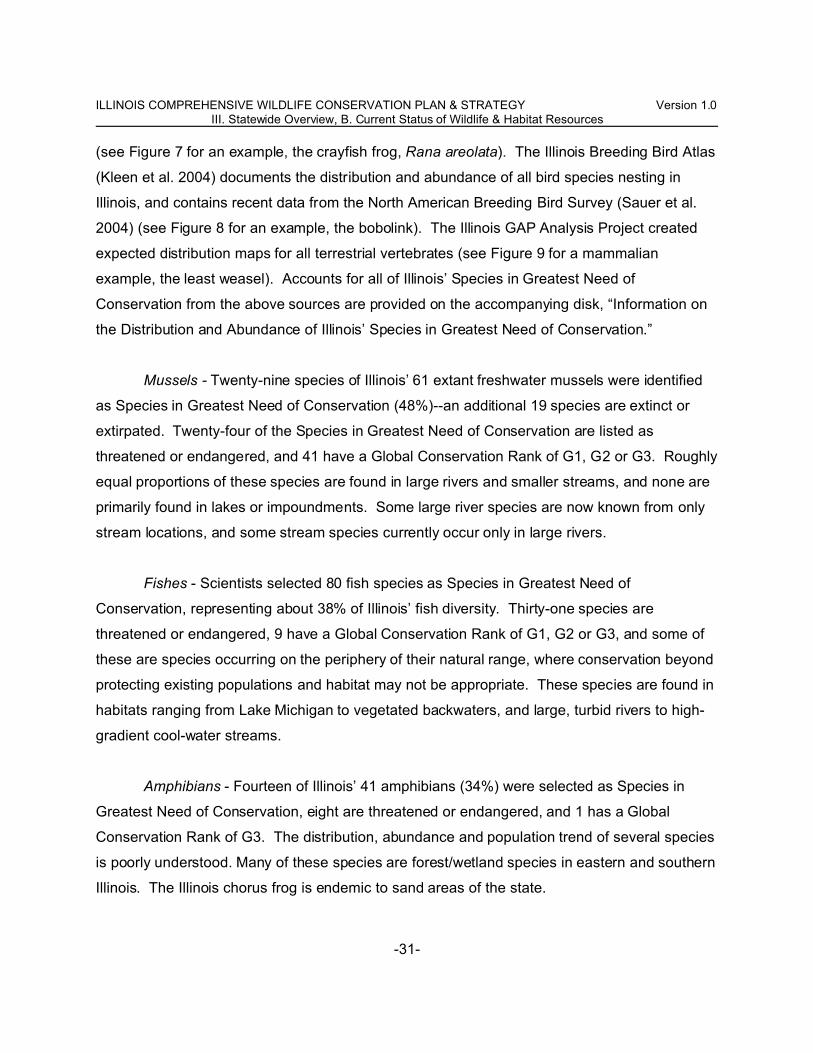
ILLINOIS COMPREHENSIVE WILDLIFE CONSERVATION PLAN & STRATEGY Version 1.0III. Statewide Overview, B. Current Status of Wildlife & Habitat Resources
-31-
(see Figure 7 for an example, the crayfish frog, Rana areolata). The Illinois Breeding Bird Atlas
(Kleen et al. 2004) documents the distribution and abundance of all bird species nesting in
Illinois, and contains recent data from the North American Breeding Bird Survey (Sauer et al.
2004) (see Figure 8 for an example, the bobolink). The Illinois GAP Analysis Project created
expected distribution maps for all terrestrial vertebrates (see Figure 9 for a mammalian
example, the least weasel). Accounts for all of Illinois’ Species in Greatest Need of
Conservation from the above sources are provided on the accompanying disk, “Information on
the Distribution and Abundance of Illinois’ Species in Greatest Need of Conservation.”
Mussels - Twenty-nine species of Illinois’ 61 extant freshwater mussels were identified
as Species in Greatest Need of Conservation (48%)--an additional 19 species are extinct or
extirpated. Twenty-four of the Species in Greatest Need of Conservation are listed as
threatened or endangered, and 41 have a Global Conservation Rank of G1, G2 or G3. Roughly
equal proportions of these species are found in large rivers and smaller streams, and none are
primarily found in lakes or impoundments. Some large river species are now known from only
stream locations, and some stream species currently occur only in large rivers.
Fishes - Scientists selected 80 fish species as Species in Greatest Need of
Conservation, representing about 38% of Illinois’ fish diversity. Thirty-one species are
threatened or endangered, 9 have a Global Conservation Rank of G1, G2 or G3, and some of
these are species occurring on the periphery of their natural range, where conservation beyond
protecting existing populations and habitat may not be appropriate. These species are found in
habitats ranging from Lake Michigan to vegetated backwaters, and large, turbid rivers to high-
gradient cool-water streams.
Amphibians - Fourteen of Illinois’ 41 amphibians (34%) were selected as Species in
Greatest Need of Conservation, eight are threatened or endangered, and 1 has a Global
Conservation Rank of G3. The distribution, abundance and population trend of several species
is poorly understood. Many of these species are forest/wetland species in eastern and southern
Illinois. The Illinois chorus frog is endemic to sand areas of the state.

ILLINOIS COMPREHENSIVE WILDLIFE CONSERVATION PLAN & STRATEGY Version 1.0III. Statewide Overview, B. Current Status of Wildlife & Habitat Resources
-32-
Reptiles - Twenty-three of Illinois’ 60 reptiles (37%) were selected as Species in
Greatest Need of Conservation, 16 are threatened or endangered, and 1 has a Global
Conservation Rank of G3. Like the fishes and amphibians, the reptilian Species in Greatest
Need of Conservation list includes edge-of-range and poorly-known species. Diversity of
reptiles is highest in southern Illinois. Species in Greatest Need of Conservation include prairie,
savanna, marsh, swamp, and bluff species. The eastern massasauga is a candidate for federal
protection under the Endangered Species Act.
Birds - Eighty-three bird species, about 28% of the state’s avian diversity, met criteria as
Species in Greatest Need of Conservation, 32 of which are threatened or endangered, and 1
species has a Global Conservation Rank of each G1 and G3. Relative to other groups, bird
populations are the best-monitored. Many of the birds in greatest need of conservation are
wetland, grassland, and long-distance migratory species, including king rails, greater prairie-
chickens, American golden plovers, and cerulean warblers.
Mammals - Twenty of Illinois’ 59 mammals (34%) were identified as Species in Greatest
Need of Conservation. Nine of these species are threatened or endangered, and four have a
Global Conservation rank of G2 or G3. More information is needed on the status of some
nocturnal or cryptic species. Bobcats and river otter are increasing and no longer listed as
threatened species in Illinois. Reports of cougars, wolves and armadillos have also become
more frequent. Black bears occur in southern Indiana, eastern Kentucky and central
Wisconsin, and may be reported from Illinois. Elk are native to Illinois but were extirpated in the
early 1800s. A study in the Shawnee Hills natural division indicated reintroduction was
biologically feasible, though agricultural conflicts were likely (Buhnerkempe and Higgins 1997).
Harvested Wildlife Resources
Sport fishes and game animals are regulated and monitored by the Illinois Department
of Natural Resources. Sport fishes support about 33 million quality angler-days of recreation
with an economic value of $1.6 billion annually, and game animals support about 7 million
hunting and trapping days with an economic value of $949 million annually (Miller et al. 2003,
2004ab; U.S. Fish & Wildlife Service 2001).

ILLINOIS COMPREHENSIVE WILDLIFE CONSERVATION PLAN & STRATEGY Version 1.0III. Statewide Overview, B. Current Status of Wildlife & Habitat Resources
-33-
Mussels
Commercial mussel harvest was an important economic endeavor in the late nineteenth
and early twentieth centuries. Degradation of rivers led to a collapse in mussel populations and
this industry. At present, harvest is restricted to ten species, in limited waters of Illinois, with
regulations on individual size, quantities and methods of harvesting mussels.
Sport fishes
Trout & salmon - In Lake Michigan, several species of trout and salmon are stocked by
Illinois and other states to maintain fishable populations. Demand far exceeds supply of fish
available. Brook trout have been extirpated from coolwater streams in northern Illinois, and few
self-sustaining populations of brown trout occur. Catchable rainbow trout are also stocked in
inland streams and lakes during spring and fall.
Northern pike, muskellunge - Pike and muskie are stocked in 66 lakes statewide.
Demand continues to be high for these fish, which are capable of reaching large size and are
highly valued by sport anglers.
Walleye, sauger, and perch - These fish are highly valued for their sporting and eating
qualities. Some natural reproduction occurs in streams (walleye, sauger) and Lake Michigan
(perch). Walleye and sauger fisheries in impoundments are maintained by stocking, and
demand far exceeds current supplies for all three species.
Black bass - Largemouth, smallmouth, and spotted bass occur in Illinois waters.
Largemouth bass are intensively managed to provide recreation and as a predator for forage
and panfish populations. Natural reproduction of largemouth bass occurs in both streams and
impoundments, however supplemental stockings are required to maintain quality fisheries in
some impoundments. Smallmouth bass are largely restricted to better-quality streams in the
northern half of the state. Bass are generally managed with restrictive size and creel limits.
Demand far exceeds bass supply.

ILLINOIS COMPREHENSIVE WILDLIFE CONSERVATION PLAN & STRATEGY Version 1.0III. Statewide Overview, B. Current Status of Wildlife & Habitat Resources
-34-
Panfish - Panfish are a group of highly sought-after, small sport fish, including bluegill
and crappies. Panfish are managed via predator introduction (bass) and by angler harvest and
creel limits. Current supply and demand are nearly equal, though demand exceeds supply in
high-quality public fisheries.
White Bass, Striped Bass & Hybrids - These popular sportfish are available in many
impoundments and streams. Demand exceeds supply.
Catfish - Channel, flathead, and blue catfish make up the majority of Illinois catfish.
Natural reproduction is common in larger lakes and streams. Channel catfish do not reproduce
well in smaller lakes, thus they are commonly stocked to produce quality fisheries. Current
supply and demand are nearly equal.
Commercial fish - Commercial fish include buffaloes, carp, carpsuckers, and freshwater
drum (and catfish as well). Asian carp have become a commercial resource, a tool that may aid
in control of these invasive species. Supply far exceeds the demand for these fish generally
found in abundance in Illinois’ largest streams. Commercial harvest values for these fish in
2002 was estimated at nearly $1.7 million.
Herptiles
Bullfrogs and common snapping turtles are the species most commonly harvested.
Both species are common statewide in streams, impoundments, lakes, and ponds, and
populations apparently are stable (Phillips et al. 1999).
Birds
Waterfowl - The Canada goose harvest is comprised primarily of birds from Illinois’
giant Canada goose population and the migratory Mississippi Valley Population. Changing
weather patterns and land uses are implicated in changing wintering distribution for geese in
Illinois. Resident Canada geese are a local nuisance. Snow goose populations are at higher
than desired levels and these birds have become common migrants in Illinois. Mallard, wood
duck, gadwall, and green-winged teal are the species most commonly harvested in Illinois, and

ILLINOIS COMPREHENSIVE WILDLIFE CONSERVATION PLAN & STRATEGY Version 1.0III. Statewide Overview, B. Current Status of Wildlife & Habitat Resources
-35-
are near or above population objectives established in the North American Waterfowl
Management Plan.
Coots, rails & shorebirds - The coot harvest is small, decreasing, and largely incidental
to harvest of other waterfowl. Few Illinois hunters pursue rails (sora, Virginia rail) or Wilson’s
snipe. While the status of rails and snipe are poorly understood, marsh, sedge meadow and
wet prairie habitats used by them are scarce and in poor condition. Harvest of woodcock in
Illinois has decreased as the regional population has declined dramatically in recent years.
Wild turkey - Following successful reintroduction to Illinois in the late 20th century,
turkeys now occur in almost all counties in Illinois. As these birds continue to pioneer
unoccupied habitat, the population (and harvest) is increasing.
Upland gamebirds - Populations and harvests of bobwhites, pheasants and gray
(Hungarian) partridge have decreased by more than 75% since 1970. Changing agricultural
practices, development, and invasive species have reduced the quality (plant diversity, structure
and disturbance patterns) and amount of available habitat, especially grassland and shrubs.
Doves & crow - The harvest of mourning doves in Illinois exceeds the harvest of all
other gamebirds combined. Populations and harvest of mourning doves are stable to slightly
decreasing. Eurasian collared-doves are beginning to appear in the bags of dove hunters as
populations exponentially increase. American crows are abundant in Illinois and a local
nuisance. West Nile Virus reduced crow abundance in some areas in recent years, with
indications populations are rebounding.
Mammals
White-tailed deer - White-tailed deer, the most popular game mammal in Illinois, are
abundant statewide, and the harvest is increasing. The herd is estimated at 750,000 to
800,000, with recent hunter harvests of about 180,000 animals. Efforts are on-going to contain
and eradicate Chronic Wasting Disease in northern Illinois. Deer-vehicle collisions,

ILLINOIS COMPREHENSIVE WILDLIFE CONSERVATION PLAN & STRATEGY Version 1.0III. Statewide Overview, B. Current Status of Wildlife & Habitat Resources
-36-
crop/property damage and adverse effects of heavy browsing on natural areas are persistent
issues, and herd size somewhat exceeds desired levels.
Rabbits & squirrels - Although cottontail and squirrel populations have been stable in
recent years in Illinois, the harvest is shrinking as fewer hunters pursue them. Swamp rabbits
are localized and uncommon in floodplain forests in southern Illinois.
Furbearers - Many furbearers are common to abundant in Illinois and harvest is limited
by trapper/hunter effort rather than population size. Badgers are widespread. Abundance of
red foxes may have decreased in recent decades due to interactions with coyotes and limited
availability of grassland habitat. Declines in the gray fox population are suspected with
unknown causes. While not legal to harvest at present, conservation efforts have recovered
the bobcat and river otter in Illinois. Reports of otter damage to fisheries (particularly in small
impoundments) are increasing.
Habitats
Much of the following summaries have been adapted from the Critical Trends
Assessment Program, a program that measures land cover (Figure 10), changes in extent,
condition, and ecological indicators of Illinois’ forests, grasslands, wetlands and streams at
randomly-selected statewide locations (Critical Trends Assessment Program 2001). Acreage
categorized as “high quality” are Grade A and B Illinois Natural Areas Inventory communities.
The Illinois Natural Areas Inventory was first completed in 1978 with the objectives of
identifying, monitoring, and prioritizing the protection of the best remaining examples of the
state’s natural communities (White 1978). Grade A and B Illinois Natural Areas Inventory sites
show little or no evidence of degradation and display climax communities, including
conservative plant species.
Forest - Currently about 12% of Illinois is covered by forest, or 4.5 million acres,
excluding the partial canopy/open woodland land cover category, considered in Open
Woodland/Savanna/Barren, below (Figure 10). The 1.1 million acres of floodplain forest,
treated as a wetland habitat in various sources, are considered as a part of broader forest

ILLINOIS COMPREHENSIVE WILDLIFE CONSERVATION PLAN & STRATEGY Version 1.0III. Statewide Overview, B. Current Status of Wildlife & Habitat Resources
-37-
habitat in the plan/strategy unless otherwise specified (Table 5). About 14,000 acres (<0.3%)
are high quality communities such as floodplain forest, upland forest, sand forest and flatwoods.
Most of the present-day forests have been fragmented into small parcels of land, and the
abundance of species that require large forested tracts to survive have declined. Small
fragmented parcels are also more susceptible to intrusion by invasive species of plants and
animals, such as garlic mustard and brown-headed cowbirds. Available evidence suggests no
forests in Illinois are of sufficient size to reliably function as “sources” (i.e., recruitment exceeds
mortality) for Neotropical migratory birds (Robinson et al. 1995), though small woodlots and
riparian forests are important stopover habitat during migration. Upland forests were
predominantly oak-hickory, and bottomland forests were predominantly ash-elm-maple.
Because of historic grazing and poor forestry practices, many forests have lost valuable
disturbance-sensitive plants, are dominated by introduced or invasive species, and contain
undesirable canopy tree species. Several possible factors, including a decrease in timber
harvest and fire suppression, are contributing to increases in sugar maples and other
mesophytic trees in many oak-dominated forests. Between 1962 and 1985 sugar maples
increased 41-fold while oaks were down 14%. In the shrub layer, bush honeysuckle, buckthorn
(Rhanmus sp.) and other invasive species average more than 70% of all shrub stems counted.
Open Woodland/Savanna/Barren - Open woodlands, savannas, and barrens are
communities with tree canopy cover intermediate of forest and prairie, and exist within a matrix
of environmental factors related to fire, topography and soil type. In these distinct plant
communities, slender glass lizard and red-headed woodpecker are among the characteristic
wildlife. The extent and condition of savanna, barren and open woodland habitats in Illinois is
poorly understood, but certainly more scarce and in poorer condition compared to recent and
historical standards. Nuzzo (1986) estimated savanna had been reduced in the Midwest by
99.98% compared to the early 19th century. Land Cover of Illinois, 1999-2000, classified
615,000 acres as ‘partial canopy/open woodland. About 1,500 acres of high quality savanna
and barren are known, 1,300 acres of which is sand savanna. The restoration potential for
degraded savannas and barrens is high, and the Kankakee Sands area contains among the
best and most concentrated remaining oak savanna (U. S. Fish & Wildlife Service 1999).

ILLINOIS COMPREHENSIVE WILDLIFE CONSERVATION PLAN & STRATEGY Version 1.0III. Statewide Overview, B. Current Status of Wildlife & Habitat Resources
-38-
Savanna remnants, associated with forests, prairie remnants and primary communities likely
exist and can be prioritized for restoration and management.
Grassland - Native prairie covered 21 million acres of Illinois in the early 19th century.
Less than 2,600 acres (<0.01%) of high-quality prairie remain. Although native prairie has been
destroyed, 19.2% of the state is categorized as “grassland” habitat (Figure 10). More than
780,000 grassland acres (17%) are in temporary agricultural programs. Most grasslands have
been plowed, heavily grazed, or frequently mowed. Few grasslands are large enough and
unfragmented by woody vegetation and human structures to support area-sensitive species.
Often dominated by planted introduced grasses, especially fescue, these grasslands do not
resemble native prairies. Of the terrestrial habitats, grasslands are the most heavily dominated
by introduced species. Most of Illinois’ grasslands are planted in monocultures or are otherwise
highly manicured. Far less than the 19.2% of the state’s land cover that is classified as
grassland habitat is actually functioning as a natural grassland ecosystem.
Shrub/successional - The extent and condition of shrub/successional habitats in Illinois
is poorly understood, though 1999-2000 land cover reported 615,000 acres of ‘partial
canopy/open woodland,’ which presumably includes some shrub/successional habitat.
Regional declines in populations of bird species using this habitat type, including northern
bobwhite, field sparrow and brown thrasher, are well-documented.
Wetland - Illinois has lost approximately 90% of its 8.2 million acres of wetlands as a
result of draining, filling, clearing, and urban development. The remaining natural wetlands
(excluding floodplain forest) now occupy about 1% of Illinois (Figure 10), and only 6,800 acres
(0.05%) are graded as high quality. Marsh-type wetlands are scarce, highly degraded, and
critical for the Species in Greatest Need of Conservation. Remaining wetlands are in poor
condition due to fragmentation, siltation, altered hydrological conditions, and the invasive
species. Invasive plant species such as reed canary grass, common reed, Eurasian milfoil and
purple loosestrife can dominate disturbed wetlands and exclude native plant species, resulting
in a loss of biodiversity. Wetland bird and insect communities are especially sensitive to
changes in hydrology, plant species composition, and habitat loss.

ILLINOIS COMPREHENSIVE WILDLIFE CONSERVATION PLAN & STRATEGY Version 1.0III. Statewide Overview, B. Current Status of Wildlife & Habitat Resources
-39-
Lake & pond - More than 644,000 inland acres of Illinois is water (including streams),
much of that human-created reservoirs and impoundments (Figure 10). About 2,000 acres of
natural lakes and ponds are considered high quality natural communities. About 6%, or nearly
1 million acres, of Lake Michigan is within Illinois. Water quality has improved greatly in recent
decades, and exotic species and water levels are priority issues for this Great Lakes
ecosystem.
Streams - At the dawn of the 20th century, most of Illinois’ 26,000 miles of streams and
rivers had sinuous courses with associated rich marshes and swamps. The stream banks were
lined with protective vegetation that reduced the likelihood of bank failures and heavy erosion.
Since then agriculture and development have drastically reduced the health of our streams —
marshes and swamps have disappeared, streams have become turbid, and their channels have
been straightened and levied. Coolwater streams, probably always uncommon in Illinois, have
been degraded by thermal pollution. Some species of freshwater mussels, environmentally
sensitive aquatic insects, and fish that were once common to Illinois waters have been
extirpated from the state. Habitat quality scores most readily confirm this degradation, and only
240 acres of stream and river habitat are considered high quality natural areas in Illinois.
Improvements in point-source pollution and better agricultural practices have improved water
quality, although centers of high human population density and agriculture have changed the
chemical signature of streams. Exotic species are likely to continue increasing. The recovery
of sensitive aquatic organisms will be delayed because of the distances between remaining
populations, and may require reintroduction along with improving stream habitat and water
quality.

ILLINOIS COMPREHENSIVE WILDLIFE CONSERVATION PLAN & STRATEGY Version 1.0III. Statewide Overview, C. Desired Conditions for Wildlife & Habitat Resources
-40-
III. C. Desired Conditions for Illinois Wildlife & Habitat Resources in 2025
Meeting the conditions described in this section will require continued and increased
partnerships, additional resources, effectiveness monitoring (i.e., ensuring conservation actions
are having the intended effects), research, and statewide and local monitoring of habitat and
wildlife resources (see Section IV, F). A 20-year horizon was arbitrarily chosen, as a
reasonable time frame within a conservationist’s career. These goals will need to be
periodically revised as natural resource conditions and social priorities change. As
implementation proceeds, local objectives and shorter-term benchmarks will need to be refined.
In future iterations of the plan/strategy, longer-term goals (e.g., related to climate change) may
be appropriate to consider.
Wildlife and habitat goals were adopted from a number of existing conservation plans,
such as the Partners in Flight objectives for several bird species in greatest need of
conservation. All programs with Illinois Department of Natural Resources’ Office of Resource
Conservation were also asked to develop wildlife objectives, and habitat objectives to support
them, considering a 20-year horizon, and habitat/wildlife conditions that could be achieved with
conservation resources (funding/staffing) that could realistically be attained over that time.
Several of these goals and objectives were further augmented and refined by other agencies
and organizations at planning workshops and through review of the plan/strategy.
Species in Greatest Need of Conservation
Only species or groups of species for which explicit population or habitat objectives have
been established are discussed in this section. It is expected that improved habitat conditions
will result in increased populations of other Species in Greatest Need of Conservation relying
on similar habitats, as well as increased populations sport fishes and game animals. Please
see Appendix II for more information on population status and objectives.
Mussels -
1. Populations at all currently-occupied locations are maintained and re-established at 50% or
more of historic locations where suitable habitat persists or can be restored.

ILLINOIS COMPREHENSIVE WILDLIFE CONSERVATION PLAN & STRATEGY Version 1.0III. Statewide Overview, C. Desired Conditions for Wildlife & Habitat Resources
-41-
Fishes -
1. Populations at all currently-occupied locations are maintained and re-established at 50% or
more of historic locations where suitable habitat persists or can be restored.
2. The Index of Biotic Integrity is maintained or improved for stream fish communities (Yoder
2003).
3. Self-sustaining populations of brook trout are restored in at least 4 streams.
Aquatic nuisance species -
1. Unintentional introductions are avoided, and range expansions and harmful effects of
invasive species are minimized.
2. Ballast water standards are implemented.
3. Rapid Response plans are in place for the Great Lakes and Mississippi River Basins.
Amphibians & Reptiles -
1. The distribution and abundance of reptile and amphibian populations are understood with
confidence, and sentinel monitoring can identify conservation needs.
2. Key species (eastern massasauga and Blanding’s turtle) have been recovered and adequate
habitat is secure.
Birds -
1. At least 2 forests larger than 50,000 acres (assumed to be large enough to reliably function
as population sources for Neotropical migratory birds) are restored and managed in the
Shawnee Hills and Ozark natural divisions.
2. Breeding populations of Partners In Flight priority forest species, including Acadian
flycatcher, cerulean warbler, ovenbird and Kentucky warbler have increased by 50%.
3. Migratory use of forests, open woodlands, savannas, and barrens by Neotropical migratory
birds has increased by 20%.
4. Breeding populations of red-headed woodpeckers have increased by 100% and eastern
kingbirds by 50%.
5. Breeding populations of Partners In Flight priority shrub/successional species, including
northern bobwhite, American woodcock and Bell’s vireo, have doubled.

ILLINOIS COMPREHENSIVE WILDLIFE CONSERVATION PLAN & STRATEGY Version 1.0III. Statewide Overview, C. Desired Conditions for Wildlife & Habitat Resources
-42-
6. Breeding population of Partners In Flight priority grassland species including upland
sandpiper, loggerhead shrike, bobolink and grasshopper sparrow have doubled.
7. Use of grassland habitats by migratory grassland sparrows, bobolinks, and meadowlarks
has increased by 20%.
8. Implementation of the greater prairie-chicken recovery plan (Walk 2004) is completed,
including recovery of northern harrier, short-eared owl, upland sandpiper, Henslow’s sparrow,
loggerhead shrike and other endangered species.
9. Breeding populations of Wilson’s snipe, sora, Virginia rails, willow flycatchers, and marsh
wrens have increased by 50%.
10. The number of multiple-species wading bird rookeries has increased by 25%.
11. Migratory shorebird use in the state has increased by 20%.
12. State-listed wetland birds, including king rail and Wilson’s phalarope, are recovered. At
least two breeding populations of black rails are reestablished.
13. Breeding and migratory wetland birds are monitored satisfactorily to identify conservation
needs.
Mammals -
1. The Illinois Department of Natural Resources’ Eastern Woodrat Recovery Plan has been
implemented and the species delisted.
2. Golden mouse and rice rat have been recovered and delisted.
3. Indiana bat maternity colonies are monitored with comprehensive statewide surveys (summer
months).
4. Key bat hibernacula (focal species: Indiana bat, southeastern bat, gray bat, Rafinesque’s big-
eared bat) in Illinois, including natural caves and abandoned mines, and monitored with
comprehensive surveys (winter months).
5. Summer habitat for Indiana bats has been restored and enhanced at the 2-3 most significant
areas.
6. Winter hibernacula for Indiana bats and other bats are established by opening
abandoned/sealed mines or protected by gating appropriate caves and mine entrances.
7. Distribution and abundance of Franklin’s ground-squirrel are known, and conservation needs
addressed.

ILLINOIS COMPREHENSIVE WILDLIFE CONSERVATION PLAN & STRATEGY Version 1.0III. Statewide Overview, C. Desired Conditions for Wildlife & Habitat Resources
-43-
8. The recovery of the recently-delisted bobcat and river otter are monitored.
Harvested Wildlife Resources
Only species or groups of species for which explicit population, harvest or habitat
objectives have been established are discussed in this section. It is expected that improved
habitat conditions will result in increased populations (that could support increased harvests) of
sport fishes and game animals not specifically mentioned and of Species in Greatest Need of
Conservation relying on similar habitats. Please see Appendix II for more information on
population status and harvest objectives.
Sport fishes
Objectives for sport fishes are derived from the “Strategic Plan for Illinois Fisheries FY02
- FY06," for the year 2015.
Trout & salmon -
1. Maintain the supply of quality angling days in streams and Lake Michigan.
2. Increase supply by 30,000 angling days in impoundments.
3. Re-establish a naturally reproducing population of lake trout in Illinois waters of Lake
Michigan.
4. Self-sustaining populations of brook trout are restored in at least 4 streams.
Northern pike, muskellunge -
1. Maintain the supply of quality angling days in streams.
2. Increase supply by 2,600 days in impoundments.
Walleye, sauger, and perch -
1. Maintain the supply of quality angling days for walleye and sauger in impoundments and
streams.
2. Maintain the supply of quality angling days for yellow perch in Lake Michigan.

ILLINOIS COMPREHENSIVE WILDLIFE CONSERVATION PLAN & STRATEGY Version 1.0III. Statewide Overview, C. Desired Conditions for Wildlife & Habitat Resources
-44-
3. Increase the supply of coolwater fish (walleye, sauger and hybrid striped bass) by 108,000
days in reservoirs.
Black bass -
1. Maintain the supply of quality angling days in reservoirs and streams for largemouth bass.
2. Increase the supply within impoundments to 5.6 million days.
3. Maintain the supply of smallmouth bass in streams.
Panfish -
1. Increase the supply of quality angling days by 21,000 within reservoirs and by 55,800 days
per year within impoundments to 10.5 million.
White Bass, Striped Bass & Hybrids -
1. Increase the supply of striped bass and hybrid striped bass by 97,000 days in streams.
2. Increase the supply of coolwater fish (walleye, sauger and hybrid striped bass) by 108,000
days in reservoirs.
Catfish -
1. Maintain the supply of quality angling days in reservoirs and streams, and increase by 33,000
days within impoundments.
Commercial fish -
1. Increase demand for quality angling days by 16,000 in reservoirs, 100,000 days in
impoundments, and 600,000 days in streams.
2. Maintain the commercial harvest in reservoirs, and increase the commercial harvest in
impoundments and streams.
Birds
Waterfowl -
1. Achieve and maintain 1970's levels of use-days by migrant duck populations (September-

ILLINOIS COMPREHENSIVE WILDLIFE CONSERVATION PLAN & STRATEGY Version 1.0III. Statewide Overview, C. Desired Conditions for Wildlife & Habitat Resources
-45-
January) on important waterfowl areas in the Illinois and Mississippi River valleys (an increase
of 38.9 million duck use-days, or 147%). Assuming average weather conditions and continental
duck populations at North American Waterfowl Management Plan levels, harvest could be
500,000 birds annually.
2. Manage migratory waterfowl in the Wabash River corridor.
3. Support breeding duck densities of 5.0 pairs/sq. km or annual breeding mallard population of
20,000 in the Glacial Lakes region of northeastern Illinois.
4. Maintain statewide nesting populations of wood ducks and other species.
5. Achieve and maintain 1991 through 1995 levels of migrant Canada goose populations as
measured by U.S. Fish and Wildlife Service Midwinter Waterfowl Survey (an increase of
175,000 birds). With migratory and resident goose populations at target levels, harvest could
be 150,000 geese annually.
6. Facilitate giant Canada goose conflict mitigation in areas where human-goose conflicts such
as property damage, risks to human health/safety, and damage to crops exist.
Wild turkey -
1. Increase the current population of wild turkeys in Illinois by 20%. Increase the harvest of wild
turkeys by 20%, to approximately 22,000 birds.
Upland gamebirds -
1. Add about 124,000 coveys to the pre-hunt autumn population, estimated at 95,000 coveys in
1999 (Dimmick et al. 2002). This population could support an annual harvest of 876,000 birds.
2. Increase the autumn pre-hunt flock of wild ring-necked pheasants to 2 million birds from an
estimated current 800,000 birds.
Mammals
White-tailed deer -
1. Short-term: increase the deer harvest to reduce the overall pre-hunt herd size to about
700,000 animals (currently at 750,000 to 800,000).

ILLINOIS COMPREHENSIVE WILDLIFE CONSERVATION PLAN & STRATEGY Version 1.0III. Statewide Overview, C. Desired Conditions for Wildlife & Habitat Resources
-46-
2. Long-term: maintain a herd of about 700,000 animals and annual harvest of about 140,000
deer.
3. Deer populations in urban and suburban settings are effectively managed.
Habitats
Goals for these major habitat types are compilations of habitat objectives derived for
individual species or guilds in the previous section. Please see Appendix III for relationships
among wildlife objectives, habitat objectives, and proposed conservation actions. Note that
habitat objectives are complimentary in nature, e.g., restoring and managing terrestrial habitats
contributes to reduced sedimentation in wetlands and streams, and thus will benefit multiple
habitats, Species in Greatest Need of Conservation, sport fishes and game animals.
Forest -
1. Implement sustainable forestry practices, including timber stand improvement, prescribed
fire, timber harvesting and invasive species control to enhance oak-dominance and maintain
understory diversity on 1 million acres of forest.
2. Increase statewide forest acreage by 350,000 acres, emphasizing restoration of floodplains
and riparian corridors, increasing ecological connectivity among forests and other habitat
patches, and reducing fragmentation of forests 500 acres and larger.
3. High-quality examples of all forest communities, including all Grade A and B Illinois Natural
Areas Inventory sites, are restored and managed within all natural divisions within which they
occur.
4. Urban forests are healthy and well-maintained.
Open Woodland/Savanna/Barrens -
1. Implement sustainable forestry practices, including timber stand improvement, prescribed
fire, timber harvesting and invasive species control to enhance oak-dominance and maintain
understory diversity of savanna/barren/open woodland habitat.

ILLINOIS COMPREHENSIVE WILDLIFE CONSERVATION PLAN & STRATEGY Version 1.0III. Statewide Overview, C. Desired Conditions for Wildlife & Habitat Resources
-47-
2. Extent and condition of open woodland, savanna, and barrens habitats are known and
monitoring can identify conservation needs.
3. Degraded habitats have been identified and restored as possible; small woodlots are
managed as open woodlands/savannas as appropriate.
4. High-quality examples of all open woodland, savanna and barren communities, including all
Grade A and B Illinois Natural Areas Inventory sites, are restored and managed within all
natural divisions within which they occur.
Grassland -
1. An additional 1 million acres of grassland, emphasizing upland, treeless grasslands larger
than 0.5 mile wide and ecological connectivity among grasslands and other habitat patches, are
established and maintained.
2. Wildlife-value (structure, floral diversity, disturbance regimes) of 1 million existing acres of
grassland are enhanced.
3. Five additional “ecological pattern” grassland Bird Conservation Areas (see Fitzgerald et al.
2000) have been established.
4. Three wet prairie areas of 1,000 to 2,000 acres, connected by dispersal corridors, are
restored and managed in the Grand Prairie natural division.
5. At least 6 areas (300-500 acres each) of ephemeral wetlands and accompanying upland
sand prairie habitat are restored and managed for Illinois chorus frogs in the inland sand areas.
6. High-quality examples of all prairie communities, including all Grade A and B Illinois Natural
Areas Inventory sites, are restored and managed within all natural divisions within which they
occur.
Shrub/successional -
1. Extent and condition of shrub/successional habitats are known and monitoring can identify
conservation needs.
2. Additional habitat has been established and is being managed.

ILLINOIS COMPREHENSIVE WILDLIFE CONSERVATION PLAN & STRATEGY Version 1.0III. Statewide Overview, C. Desired Conditions for Wildlife & Habitat Resources
-48-
3. As appropriate, small woodlots and forests have native shrub-dominated, early successional
edges and perennial herbaceous borders.
4. Herbaceous and shrub corridors link isolated upland habitat patches in areas of intensive
agriculture.
Wetland -
1. A net gain of 20% of marsh wetland types is achieved through restoration, enhancement and
management.
2. A net gain of 40% of combined wetland types is achieved in the river bottomlands natural
divisions of Illinois.
3. Ephemeral and fishless semi-permanent wetlands (i.e. vernal pools, prairie potholes,
landscape depressions) support objectives for dependent species of wildlife (e.g., dragonflies,
amphibians).
4. Moist-soil management strategies adopted on public waterfowl management areas and other
sites increase wading bird, waterfowl, shorebird, and other wildlife use.
5. The integrity of water quality is maintained on a statewide basis.
6. Local residents in areas under high development pressure and/or within fragile geographic
zones (i.e. karst terrain) are educated and manage lands and waters to maintain or improve
water quality.
7. Total sediment delivery to wetlands is reduced.
8. High-quality examples of all wetland communities, including all Grade A and B Illinois Natural
Areas Inventory sites, are restored and managed within all natural divisions within which they
occur.
Lake & Pond -
1. No net loss of the productive capacity of habitat supporting Lake Michigan’s fish
communities, including suppressing sea lamprey, sustaining native fish communities, and
restoring riverine spawning and nursery areas.

ILLINOIS COMPREHENSIVE WILDLIFE CONSERVATION PLAN & STRATEGY Version 1.0III. Statewide Overview, C. Desired Conditions for Wildlife & Habitat Resources
-49-
2. The supply of quality angling days is increased by 2.0 million by expanding and improving
accessible impoundments.
3. Total sediment delivery to lakes and ponds is reduced.
4. Sediments are removed from lakes and ponds for beneficial uses.
5. Rapid Response plans are implemented for the Great Lakes basin and Mississippi River
basin (covering all of Illinois). An aquatic nuisance species barrier protects the Great Lakes
and Illinois River basin from biological invasions.
6. The integrity of water quality is maintained on a statewide basis.
7. Local residents in areas under high development pressure and/or within fragile geographic
zones (i.e. karst terrain) are educated and manage lands and waters to maintain or improve
water quality.
8. High-quality examples of all lake and pond communities, including all Grade A and B Illinois
Natural Areas Inventory sites, are restored and managed within all natural divisions within which
they occur.
Streams -
1. Baseline conditions of system functioning and sustainability, against which change can be
measured, are understood. A stream classification system ensures all stream types are
represented in conservation planning and implementation.
2. Tributary streams are restored to reduce head-cutting and sediment transmission to large
rivers. Streambank erosion control techniques address instream habitat needs and incorporate
natural riparian buffers.
3. Total sediment delivery to Illinois’ rivers and streams is reduced. Excessive sediment
delivery is eliminated to specific high-value habitat along main channels and tributaries of rivers
and streams.
4. Sediments are removed for beneficial uses and compacted to improve substrate conditions
for aquatic plants, fish, and wildlife.
5. Backwaters are restored and rehabilitated to provide a diversity of depths.

ILLINOIS COMPREHENSIVE WILDLIFE CONSERVATION PLAN & STRATEGY Version 1.0III. Statewide Overview, C. Desired Conditions for Wildlife & Habitat Resources
-50-
6. Main stem and main stem-to-tributary connectivity are restored and maintained, where
appropriate, on major rivers and streams. Dysfunctional dams and spring impoundments are
removed, and necessary dams are modified to accommodate fish passage. All existing
connections between backwaters and main channels are maintained.
7. Riparian habitats are restored and protected.
8. Isolated and connected floodplains are restored and managed along rivers and streams to
promote floodplain function and habitats.
9. Side channel habitats are restored and maintained.
10. Land alterations that contribute to unnatural water level fluctuations, flow regimes and ater
temperatures in rivers and streams are identified and addressed.
11. Low-water fluctuations are reduced where possible, particularly during the months of May
through October.
12. Peak flows are reduced by 2 to 3 percent for 2- to 5-year recurrence storm events, reducing
peak flood stages and high-water fluctuations.
13. The dramatic water level changes associated with operation of wicket dams have been
removed. Water releases from reservoirs are managed to protect downstream flow needs and
the integrity of floodplain ecosystems.
14. System-wide limiting factors for representative native species or communities, including
altered disturbance regimes (hydrology, connectivity), excessive sedimentation, thermal
pollution, reduction and fragmentation of aquatic and riparian habitat, water and sediment
quality problems, and invasive species, are identified and addressed.
15. Natural habitats, including concentrations of flora and fauna, areas that are especially
vulnerable to disturbance and/or important in fulfilling a life-history requirement of the species
present, and specific suitable habitat for endangered or special concern species, are restored
and enhanced.
16. Rapid Response plans are implemented for the Great Lakes basin and Mississippi River
basin (covering all of Illlinois). An aquatic nuisance species barrier protects the Great Lakes
and Illinois River basin from biological invasions.
17. The integrity of water quality is maintained on a statewide basis.

ILLINOIS COMPREHENSIVE WILDLIFE CONSERVATION PLAN & STRATEGY Version 1.0III. Statewide Overview, C. Desired Conditions for Wildlife & Habitat Resources
-51-
18. Local residents in areas under high development pressure and/or within fragile geographic
zones (i.e. karst terrain) are educated and manage lands and waters to maintain or improve
water quality.
19. High-quality examples of all river and stream communities, including all Grade A and B
Illinois Natural Areas Inventory sites, are restored and managed within all natural divisions
within which they occur.
Cave -
1. Water quality within cave recharge areas is improved and maintained.
2. Local residents in areas under high development pressure and/or within fragile geographic
zones (i.e. karst terrain) are educated and manage lands and waters to maintain or improve
water quality.
3. Destruction of surface and sub-surface watersheds is avoided.
4. Natural vegetation buffers are maintained around caves/springs.
5. Water quality monitoring within significant cave systems is adequate to identify system
changes.
6. High-quality examples of all cave communities, including all Grade A and B Illinois Natural
Areas Inventory sites, are restored and managed within all natural divisions within which they
occur.
Primary -
1. High-quality examples of all primary communities, including all Grade A and B Illinois Natural
Areas Inventory sites, are restored and managed within all natural divisions within which they
occur.

ILLINOIS COMPREHENSIVE WILDLIFE CONSERVATION PLAN & STRATEGY Version 1.0III. Statewide Overview, D. Challenges for Wildlife & Habitat Resources
-52-
III. D. Challenges for Illinois Wildlife & Habitat Resources
This section highlights the stresses affecting groups of wildlife and habitats. Stresses
were categorized as habitat-related, population-related (e.g., genetics), community-related
(e.g., predation), and directly human-related (e.g., killing), and ranked as weak, moderate, and
strong effects. These assessments were completed by teams of experts, but for many Species
in Greatest Need of Conservation, high quality scientific information was not available. Thus,
scientists also scored every stress assessment with moderate-to-high confidence, low
confidence, or very low confidence.
It is important to note that stresses were considered as factors directly affecting wildlife
and habitat (see Appendix II), and not the sources of those stresses. (For example, loss of
habitat is a stress, whereas an agriculture practice or development may be the source of that
stress.) In many cases, the sources of stresses are apparent or well-known. Others are not
well-understood, and require investigation. Sources of stress (including lack of knowledge) are
primarily described in the “Issues” segments, and immediately addressed with specific
conservation actions, in the seven campaigns of Sect. III, E (Priority Actions for Conserving
Illinois Wildlife & Habitats).
Many of the Species in Greatest Need of Conservation, sport fishes, and game animals
are limited by similar factors. Interestingly, stresses relating to habitat quality and condition,
such as composition and disturbance patterns, are as problematic as the total amount, or
extent of habitat. Please review Appendix II for stress assessments of individual species and
habitat types.
Species in Greatest Need of Conservation
Invertebrates
Mussels - Water quality and sedimentation were identified as the primary threat to these
species. Recruitment, availability of host species, and changes in hydrology are also

ILLINOIS COMPREHENSIVE WILDLIFE CONSERVATION PLAN & STRATEGY Version 1.0III. Statewide Overview, D. Challenges for Wildlife & Habitat Resources
-53-
challenges. Fragmentation of streams by dams is impeding the movements mussel hosts
(fishes). Most aspects of mussel ecology are poorly understood.
Other Invertebrates - Data are lacking for most of the invertebrate species, making it
difficult to determine Species in Greatest Need of Conservation, and to evaluate stresses that
may be affecting those species. Biologists presume similar stresses are affecting invertebrates
as the other Species in Greatest Need of Conservation, but perhaps more intensely. For
example, many insects are dependent on specific host plants or animals, and likely are more
adversely affected by degrading natural communities. Aquatic invertebrates, often with smaller
body size, shorter lifespans, and lesser abilities to seek out new, better habitats, may be more
affected by periods of poor water quality.
Fishes Water quality and sedimentation, which also affect the composition and structure of
aquatic habitats, are stressing fishes in greatest need of conservation. Quality of many aquatic
habitats, defined by vegetation, water temperature, flow, substrate and other factors, are
limiting most species. Fragmentation of remaining aquatic habitats, by other unsuitable aquatic
habitats, dams and levees, stresses small, isolated populations. Competition of invasive
species is increasing.
Amphibians The extent of habitat, disturbance regimes and altered hydrology, structure and
composition of habitat, and habitat fragmentation are the primary challenges to the amphibian
Species in Greatest Need of Conservation. Recruitment is also thought to be problematic, but
not well understood. Given amphibians’ sensitivity to environmental factors, it will be
increasingly important to minimize local stressors such as habitat loss and pollutants in order to
reduce the effects of climate change (Inkley et al. 2004).
Reptiles Recruitment (specifically relating to high predation rates on eggs and juveniles), while
not well understood, is thought to be a serious threat to the reptiles in greatest need of
conservation. Mortality due to roadways, habitat extent, composition and structure, disturbance
regimes and fragmentation, and genetics are also challenges to these populations.

ILLINOIS COMPREHENSIVE WILDLIFE CONSERVATION PLAN & STRATEGY Version 1.0III. Statewide Overview, D. Challenges for Wildlife & Habitat Resources
-54-
Birds All habitat issues (extent, composition and structure, fragmentation, disturbance regimes,
and invasive plants) are and likely will continue to challenge the avian Species in Greatest Need
of Conservation. Recruitment (relating to high predation rates of eggs and juveniles), mortality,
and human structures and infrastructures (windows and wind turbines) are also of high concern
for many of these species.
Matthews et al. (2004) modeled the effects of climate change on 150 species of birds in
eastern United States. Generally, ranges are predicted to shift northward, with many species
expected to become restricted in or extirpated from Illinois (e.g., red-headed woodpecker,
bobolink) . Other species are likely to expand their range or pioneer into Illinois (e.g., little blue
heron, Bachman’s sparrow).
Mammals The severity of challenges vary considerably among the mammal species in greatest
need of conservation, though habitat extent and fragmentation are the most important for the
group as a whole. High bat mortality at wind turbines has been reported in other states, and
wind energy is a rapidly growing industry in Illinois. Disturbance of hibernacula is a serious
potential stress to wintering bats.
Harvested Wildlife Resources
Sportfishes Recruitment is an on-going challenge for many native sport fish, which in many
lakes and rivers are maintained by stocking (black bass, channel catfish, lake trout, sauger).
Other stocked fishes (e.g., brook trout, muskellunge) seldom reproduce naturally in Illinois, but
may when high-quality habitat and conditions (e.g., coolwater streams) are restored. Water
quality and sedimentation, which also affect the composition and structure of aquatic habitats,
are stressing some sport fisheries. Smallmouth bass are negatively affected by stream
channelization and lack of riparian habitat. Invasive species, such as Asian carp, are a growing
challenge.
Birds The major challenges to the game birds are habitat-associated, especially with wetlands,
grasslands, and shrub/successional habitat. The related factors of composition and structure,

ILLINOIS COMPREHENSIVE WILDLIFE CONSERVATION PLAN & STRATEGY Version 1.0III. Statewide Overview, D. Challenges for Wildlife & Habitat Resources
-55-
disturbance patterns, invasive plants, and fragmentation are greater challenges than the current
extent of habitat. Changing forest composition may affect wild turkey abundance in the future.
Nearly all climate change models predict reduced soil moisture (strongly correlated with the
abundance of small wetlands) for the Prairie Pothole region of the northern United States and
southern Canada (Inkley et al. 2004), where most ducks harvested in Illinois are produced.
Mammals Relative to other groups, the furbearers and game mammals are perceived as
secure in Illinois. While habitat quantity and quality are important, most of these species have
proven adaptable to a wide range of habitat conditions. Chronic Wasting Disease, currently
restricted to a few counties in northern Illinois, is a threat to the white-tailed deer herd.
Habitats
The following key statewide findings are from a report of the Critical Trends Assessment
Program (2001), and highlight a number of the most significant challenges to the streams,
wetlands, grasslands, and forests of Illinois:
• habitat fragmentation is a widespread problem that limits attempts to maintain and
enhance biodiversity,
• habitat degradation is a widespread problem that could be slowed or minimized by
simply removing the degradation factors, such as improper grazing,
• if degradation is severe, restoration to predisturbance condition will likely require
intensive vegetation management,
• restoring native vegetation along streams would shade the streams, stabilize banks,
and filter sediment and chemicals from runoff before they reached the streams, resulting
in less siltation and desiccation and lower water temperatures, and
• setting prescribed fires in terrestrial ecosystems, such as prairies, marshes, savannas

ILLINOIS COMPREHENSIVE WILDLIFE CONSERVATION PLAN & STRATEGY Version 1.0III. Statewide Overview, D. Challenges for Wildlife & Habitat Resources
-56-
and oak-dominated forests, that need regular burning would maintain and enhance their
characteristics and diversity.
Based on a assessment process similar to that used for the Species in Greatest Need of
Conservation (only habitat-related stresses; see Appendix II), the stresses affecting eight major
important habitat classes in Illinois are summarized in the following section.
Forest - Maintaining and improving the quality of Illinois’ forest will be considerably more
challenging than maintaining or increasing the amount of forest acreage, which has been
steadily increasing since the 1920s. Composition and structure, disturbance regimes, and
invasive species all received the highest stress scores. Fire exclusion, poor timber harvest
practices (namely high-grading and single tree selection methods), grazing/over-grazing,
increasing sugar maple and mesophytic tree species, invasive exotic plants and insects, and
diseases are changing Illinois’ forests. Illinois’ forests are highly fragmented, a trend
accelerating due to exurban development.
Open Woodland/Savanna/Barren - Composition and structure, disturbance regimes and
invasive species are priority concerns, as is the extent of savanna habitat. Savanna-like
habitats apparently continue to decline due to destruction, improper grazing, and succession
into closed forest in the absence of fire, timber harvest and other disturbances. Oak savannas,
especially mesic savannas, are vulnerable to rapid invasion by shade tolerant species in the
absence of fire. When undesirable trees are too large to be affected by prescribed fire, they
must be physically removed for restoration.
Grassland - Once the dominant land cover in Illinois, native prairie has been eliminated
from The Prairie State. The remaining “postage stamps” of prairie are threatened by
succession, fire suppression, invasive species, and conversion to other land uses. In spite of
an increase of more than 780,000 acres of idle grassland through the Conservation Reserve
Program since 1985, Illinois has experienced a net loss of more than half of its grassland
habitat over 50 years as grasslands, including hay and pasture, have been converted to
rowcrops and developed lands. Stresses to habitat quality (fragmentation, composition and

ILLINOIS COMPREHENSIVE WILDLIFE CONSERVATION PLAN & STRATEGY Version 1.0III. Statewide Overview, D. Challenges for Wildlife & Habitat Resources
-57-
structure, disturbance regimes such as poorly-timed and unnecessary mowing, invasive
species), severely limit the ability of existing grasslands to function as a natural community that
provides suitable habitat for wildlife. Most remaining grasslands are too small to attract area-
sensitive species, and the juxtaposition of grassland, relative to wetlands, savannas,
shrub/successional habitat, and cropland are very important to many farmland species.
Climate change over the next century may make grassland habitat, and tallgrass prairie
in particular, more difficult to maintain in Illinois. Simulated vegetation responses by 2100 to
climate change models predict a shift from a savanna/woodland climate of present to a
temperate deciduous forest and southeastern mixed forest climate. Atmospheric CO2
enrichment further favors plants with C3 photosynthesis (e.g., trees, shrubs and cool-season
grasses) over the many tallgrass prairie species with C4 photosynthesis physiology (see
discussion in Inkley et al. 2004).
Shrub/successional - Though reliable knowledge is not available, anecdotal reports and
population trends of certain species suggest concern for the extent and condition of shrubland
and early successional habitats. Loss of pastures, old fields, idle areas and fence rows in
agricultural areas and reduction of timber harvest and burning in woodlands have contributed to
a decrease of this habitat type. Invasive shrub species are replacing native shrubs and
increasing in forest understories, with unknown effects on shrubland wildlife.
Wetland - The quantity and quality (fragmentation, composition and structure,
disturbance regimes, invasive species, pollution and sedimentation) of wetlands in Illinois are
problematic. While conservation actions have led to localized increases in wetland acres and
improvement in condition, the statewide trend is towards wetland loss and deterioration. Many
restored wetlands are isolated, poorly managed after construction, and could be greatly
improved for wildlife benefits (Phillips and Brown 2004).
Lake & pond - Volume loss to sedimentation is the primary stress for lake and pond
habitat in Illinois. Invasive species, sedimentation, shoreline development, and boat traffic have

ILLINOIS COMPREHENSIVE WILDLIFE CONSERVATION PLAN & STRATEGY Version 1.0III. Statewide Overview, D. Challenges for Wildlife & Habitat Resources
-58-
reduced submersed and emergent vegetation, harming composition and structure. Nutrient
loading has lead to eutrophication in many bodies of water as well.
Streams - Substrate composition and structure of streams is negatively affected by
sedimentation, dredging and channelization. Dams and levees fragment stream reaches and
adjacent habitats in many watersheds, and rapid run-off from agricultural and urban areas
combined with water releases from dams, result in extreme flow regimes. Invasive fishes and
invertebrates are significant problems in the larger rivers.
Cave - Water quality and availability and human disturbance or damage are the primary
issues for the conservation of cave habitats and the sensitive species they support.
Groundwater protection and pollution prevention are critical in karst regions. Abandoned mines
can provide additional habitat for hibernating bats if entrances are properly protected for human
safety and to prevent disturbance.

ILLINOIS COMPREHENSIVE WILDLIFE CONSERVATION PLAN & STRATEGY Version 1.0III. Statewide Overview, E. Priority Conservation Actions
-59-
III. E. Priority Conservation Actions for Illinois Wildlife & Habitat Resources
Based upon the status of Illinois’ wildlife and habitat resources, objectives for
conservation, problems affecting wildlife and habitat resources, and discussions of priorities
among conservation agencies and organizations, the following seven “campaigns” were
developed. These campaigns seek to address the most widespread and the most urgent
issues affecting wildlife and habitats, in an efficient, effective, and comprehensive manner.
Each campaign overlaps broadly with the others, and the campaigns should be considered in
combination rather than in isolation. Please see Appendix III for the how the priority
conservation actions within the campaigns address the problems affecting habitat and wildlife
resources, and performance measures for each conservation action.
While many other conservation actions are on-going or were proposed, only the highest
priority actions for achieving statewide objectives are included in this section. In several cases
where actions must be undertaken in one or few natural divisions to reach statewide objectives,
those locations are indicated in this section. Conservation actions that are essential to reaching
regional and local objectives are further described in treatments of the 15 natural divisions,
which include descriptions of priority actions within conservation opportunity areas (Sect. IV).
Many of the actions described in this section are currently being undertaken by various
agencies, organizations and citizens. These actions are intended to build upon and improve
on-going conservation to achieve statewide objectives. Existing programs and staff with local,
state, regional and federal interests are in place, and likely will be avenues for future changes
and improvements.

ILLINOIS COMPREHENSIVE WILDLIFE CONSERVATION PLAN & STRATEGY Version 1.0III. Statewide Overview, E. Priority Conservation Actions
-60-
Streams Campaign
Issues
Many problems with Illinois’ streams originate on uplands and at headwaters. Waters
from agricultural fields and urban areas carry nutrients (from natural sources and fertilizers) and
other pollutants, contributing to eutrophication at locations far downstream. Retirement of
environmentally-sensitive lands from rowcrop production and conservation tillage practices
have greatly reduced the amount of silt that enters streams in recent decades. Tiling and
channelization of headwater streams have increased the speed at which waters enter the
state’s river systems. In developed areas, waters accumulate high loads of nutrients and
pollutants, and drain very rapidly from impervious surfaces. Wastewater treatment and
reduction in industrial pollutants have significantly improved water quality downstream of urban
centers.
Improved drainage on agricultural and developed lands, coupled with levee systems that
disconnect rivers from floodplains, have altered the hydrologic patterns in Illinois’ streams, with
flooding becoming more frequent and more severe. High-energy drainage waters are
contributing to gully, stream bank erosion and channel incision–important sources of sediment
that add to the “legacy” sediments from uplands that are currently moving through Illinois’
streams. The lack of riparian forests along many streams contributes to banks becoming
unstable and for allowing direct sunlight to warm waters. In some locations, ground water
supplies have become contaminated by pollutants, and water tables are being drawn down as a
result of municipal, industrial and irrigation usage.
Dams on many of Illinois’ rivers have created “silt traps” in impoundments and
reservoirs. Lakes and ponds with connections to streams have lost significant volume to
sediments. The lock-and-dam system on the Illinois, Mississippi and Ohio Rivers has created a
series of lakes in place of a continuous stream, changing habitat conditions and substrate
composition to the detriment of many species. Dams fragment stream reaches for many
species of aquatic wildlife, and levees isolate important spawning habitats.

ILLINOIS COMPREHENSIVE WILDLIFE CONSERVATION PLAN & STRATEGY Version 1.0III. Statewide Overview, E. Priority Conservation Actions
-61-
Invasive species, including zebra mussels and Asian carp, are particularly problematic in
larger rivers in Illinois. Common carp have destroyed submersed and emergent aquatic
vegetation in many rivers and backwaters. Several fishes and freshwater mussels have
become extirpated within the past 200 years, and many more are endangered in the state.
Only 200 acres of streams in Illinois are recognized as high-quality natural communities.
Actions
1. Develop and promote upland agricultural practices that decrease the energy, sediment load,
temperature, and pollutant load of drainage waters
a. establishment of native perennial vegetation on highly erodible soils
b. use of buffer vegetation at land-water transitions
c. wetland enhancement and restoration
d. conservation tillage or no-tillage practices
e. precision nutrient applications
f. limiting livestock access to streams
g. water control structures on subsurface tile drains for seasonal use
h. continued protection of stream waters and groundwater from nitrates, bacteria and
other contaminants derived from livestock waste
2. Develop and promote practices that decrease the energy, sediment load, temperature, and
pollutant load of drainage waters from developed (urban, suburban) lands
a. wetland enhancement and restoration, and other tools for flood water retention; use
retention facilities to hold floodwaters for an adequate length of time
b. minimizing impervious surfaces
c. zoning guidelines to promote smart growth and minimize effects on environmentally-
sensitive lands (e.g., highly erodible soils)
d. maintenance and improvement of wastewater treatment facilities
e. appropriate nutrient applications on landscaped vegetation
3. Protect, restore and enhance near-stream and in-stream habitats and processes
a. restore and manage grassy buffers, wetlands, riparian forests, and flood plains

ILLINOIS COMPREHENSIVE WILDLIFE CONSERVATION PLAN & STRATEGY Version 1.0III. Statewide Overview, E. Priority Conservation Actions
-62-
b. restore tributary streams to reduce head-cutting and sediment transmission to large
rivers
1. buffer and restore channels of the Vermilion (Wabash), Embarras, and Little
Wabash rivers and their tributaries to benefit the high diversity of aquatic
Species in Greatest Need of Conservation in the Wabash River Natural Division
2. restore and manage the Wabash River, the largest unchannelized and
unimpounded river in Illinois
3. buffer and restore channels in 8-10 small headwater stream segments >5
miles to support listed fishes and mussels in each the Northeastern Morainal,
Grand Prairie, Rock River Hill Country, Wisconsin Driftless, and Illinois River and
Mississippi River Sand Areas natural divisions
c. re-meander channelized streams; provide technical assistance, publish and market to
drainage districts best practices that reduce erosion and improve habitat while lowering
costs
d. re-establish and maintain connectivity of the main stem, main stem-tributary, channel-
floodplain, and channel-backwater on rivers and streams where appropriate
e. restore normal flood-pulse and hydrologic patterns
1. remove the dramatic water level changes associated with operation of wicket
dams
2. reduce low-water fluctuations where possible, concentrating on the months of
May through October
3. reduce peak flows by 2 to 3 percent for 2- to 5-year recurrence storm
events–this will help to reduce peak flood stages and reduce high-water
fluctuations along the river
f. dredge sediments where necessary
g. compact sediments to improve substrate conditions for aquatic plants, fish, and
wildlife
h. restore and rehabilitate backwaters to a diversity of depths (5% >9 feet, 10% 6-9 feet,
25% 3-6 feet, and 60% <3 feet)
i. remove unnecessary dams and fit necessary dams with effective fish passage
structures

ILLINOIS COMPREHENSIVE WILDLIFE CONSERVATION PLAN & STRATEGY Version 1.0III. Statewide Overview, E. Priority Conservation Actions
-63-
j. restore and maintain side channel habitats
k. regulate reservoir releases to assure seasonal inundation of oxbows and backwaters
and to maintain the integrity of floodplain forests
4. Restore populations of imperiled and extirpated aquatic animals
a. maintain populations at all currently-occupied locations and re-establish populations
at 50% or more of historic locations where suitable habitat persists or can be restored.
The recovery of aquatic endangered and threatened animals will depend on restoration
and enhancement of existing aquatic habitats, such as pools, riffles, and lateral
wetlands. It will be necessary to re-create wetland habitats for amphibians and
dragonflies.
1. protect and enhance Round Pond for the river cooter and other reptile species
2. protect the Vermilion River (Illinois), lower Fox River and tributaries for benefit
of listed redhorse species
3. restore the Saline River and its tributaries to benefit Ohio River drainage
mussels and crayfish in the Shawnee Hills natural division
4. restore and protect Crane Creek (Sangamon River) and other groundwater
fed, well-vegetated streams supporting unique fish communities
5. restore coolwater streams, particularly within the Apple and Rock River
watersheds
b. reintroduce native species into stream habitat where decimating factors have been
eliminated and natural recovery is unlikely
c. collaboration among the Illinois Endangered Species Protection Board, Illinois
Department of Natural Resources, U.S. Fish & Wildlife Service and other agencies,
organizations and institutions on recovery plans and actions for rare and declining
species
5. Prevent and control invasions of detrimental exotic species
a. implement Rapid Response plans for the Great Lakes basin and Mississippi River
basin, covering all of Illinois

ILLINOIS COMPREHENSIVE WILDLIFE CONSERVATION PLAN & STRATEGY Version 1.0III. Statewide Overview, E. Priority Conservation Actions
-64-
1. Prevent invasion by black carp in the Upper Mississippi River and Illinois River
watersheds
b. install an aquatic nuisance species barrier that protects the Great Lakes and Illinois
River basin from biological invasions
c. continue removal and control (chemical, mechanical and biological) of invasive exotic
species, especially within high quality natural areas
6. Restore and manage high-quality examples of all river, stream, lake, and pond communities,
including all Grade A and B Illinois Natural Areas Inventory sites, in all natural divisions within
which they occur
7. Fill information gaps and develop conservation actions to address stresses
a. understand baseline conditions of system functioning and sustainability, against which
change can be measured
b. identify and address system-wide limiting factors for representative native species or
communities, including, but not limited to, altered natural disturbance regimes
(hydrology, connectivity, etc.), excessive sedimentation, reduction and fragmentation of
aquatic and riparian habitat (habitat patch size, habitat spacing, lateral and longitudinal
connectivity), water and sediment quality problems, and invasive species
c. develop flow standards for all rivers
d. evaluate drainage maintenance procedures in Illinois’ rivers to protect important
remnant habitats and avoid stream bed erosion
e. identify and quantify land alterations that contribute to unnatural fluctuations and flow
regimes in rivers and streams.
f. identify local opportunities (isolated backwaters, potential moist-soil floodplain areas)
and implement projects to provide basis for larger restoration projects.
g. identify areas in the Green River and Rock River drainages that can be conserved to
sustain populations of weed shiner and blacknose shiner
h. identify beneficial uses of sediments
i. develop and implement guidelines for sustainable use of surface and ground waters
for residential, commercial, agricultural and recreational uses by all of Illinois’ citizens

ILLINOIS COMPREHENSIVE WILDLIFE CONSERVATION PLAN & STRATEGY Version 1.0III. Statewide Overview, E. Priority Conservation Actions
-65-
8. Coordinate stream and watershed conservation actions with other agencies, organizations
and upstream and downstream states to meet system-wide objectives
9. Increase water quality education efforts in areas under high development pressure and/or
within fragile geographic zones (i.e. karst terrain)
10. Marketing and technical assistance will be required for adoption and appropriate
implementation of the streams campaign.

ILLINOIS COMPREHENSIVE WILDLIFE CONSERVATION PLAN & STRATEGY Version 1.0III. Statewide Overview, E. Priority Conservation Actions
-66-
Forests Campaign
Issues
The quality of Illinois’ wooded habitats–forest, open woodlands, savannas, barrens, and
shrublands–is a major concern. Alteration of natural disturbance processes, including flooding
regimes and suppression of fire, but also inappropriate timber harvest done without professional
forestry assistance, are contributing to changing composition of forested habitats, notably the
increase in maples, other mesophytic trees and closed forests types, and decrease in oak-
hickory dominance and open forest types.
A general decline in management of wooded habitats (prescribed fire and lack of
professional forestry staff to assist private forest owners), has led to stark transition areas
between open agricultural fields or grasslands and closed forest. Drainage waters leaving
agricultural and urban areas at high velocity and entering the sparsely-vegetated floors of
closed forests leads to gully erosion, delivering sediment and high energy waters to streams.
The rate at which invasive exotic species degrade forested habitats is increasing.
Chestnut blight and Dutch elm disease have reduced the diversity of canopy species, whereas
Osage orange and black locust dominate canopies of former pastures and reclaimed mine
lands, respectively. Oak decline is a local, poorly-understood problem. Gypsy moths, Asian
long-horned beetles and emerald ash borers have the potential to devastate urban and rural
forests. Shrubs, including honeysuckles and buckthorns, degrade forest communities by
reducing the abundance and diversity of native shrubs and herbaceous plants, increasing bare
soils and erosion potential, reducing wildlife diversity, and inhibiting recruitment of desirable tree
species. Vines (e.g., kudzu) and herbaceous plants (e.g., garlic mustard) further reduce
biodiversity. Each invasion tends to reduce stability of forest systems, increasing the probability
and severity of the next invasion.
Illinois’ forests were naturally dissected along riparian areas, but have been further
fragmented by clearing for agriculture and development. Fragmentation contributes to the
invasion of nonnative species, and exacerbates natural wildlife interactions such as high rates

ILLINOIS COMPREHENSIVE WILDLIFE CONSERVATION PLAN & STRATEGY Version 1.0III. Statewide Overview, E. Priority Conservation Actions
-67-
of predation by generalist predators and parasitism of songbird nests by brown-headed
cowbirds to undesirable levels. Fragmentation of forests continues from a variety of sources,
with exurban development a noteworthy challenge.
Available information suggests populations of Neotropical migratory birds in most, if not
all, of Illinois forests are “sinks” with low recruitment and sustained by immigration from forests
beyond Illinois (Robinson et al. 1995). However, whether a specific forest patch is a “source” or
“sink” is difficult to quantify with available methods, and likely varies among species and years.
While value as nesting areas is debatable, isolated woodlots and forests along rivers and
streams are important during spring and fall migration, though these benefits are also difficult to
measure.
The white-tailed deer herd is very large in Illinois, as deer have proven highly adaptable
to fragmented forests and tolerant of proximity to people, resulting in increasing deer-human
conflicts (including automobile accidents and crop damage) and damage to natural community
composition through intensive browsing. Hunter access to forests to control the deer herd is a
growing concern, as an increasingly urbanized public has fewer ties to rural and agricultural
landowners, landowners face increased demand for access and changing liability risks, and
suburban and exurban development restricts the proportion of wooded habitats that can be
hunted.
To aid private forest owners, the Illinois Department of Natural Resources administers
the Illinois Forestry Development Act, a program for managing forests for wood products.
Illinois Forestry Development Act offers reduced property tax liabilities, technical assistance,
and state cost-sharing to achieve improved wildlife habitat, soil stabilization, and improved
water quality.
Actions
1. Maintain and enhance the composition of Illinois’ forested habitats
a. reintroduce natural disturbances or suitable substitutes on a large scale
1. prescribed fire should be applied, where appropriate, to maintain or restore

ILLINOIS COMPREHENSIVE WILDLIFE CONSERVATION PLAN & STRATEGY Version 1.0III. Statewide Overview, E. Priority Conservation Actions
-68-
open woodland habitats (e.g., savanna, barren), promote oak-hickory
regeneration, stimulate the germination and production of native ground-layer
plants and control invasive species
2. sustainable forestry practices will be necessary to restore and manage open
forest habitat types in locations that have matured to closed forest or been
invaded by undesirable woody species, to mimic natural processes in areas
where fire is not an appropriate management tool, to supplement fire where
undesirable trees have grown too large to be controlled safely with fire, and
create diverse age classes of forest necessary to sustain wildlife species
requiring various successional forest stages. The economic benefits of
sustainable forestry practices provides an incentive for landowners to improve
the quality of their forests.
b. edges of forested habitats should be widened to create broader transition areas from
grassland, shrub/successional, savanna/open woodland, to closed forest, thus providing
more and better habitat for most wildlife species in greatest need of conservation and
slowing drainage waters from agricultural or developed lands prior to entering streams
c. in regions of Illinois where upland forests are highly fragmented, management for
shrub/successional, savanna/barren and open woodlands should be emphasized. While
“interior” forest conditions are fully achieved for many species only in compact forests
exceeding 50,000 acres (e.g., low brood parasitism rates of nests of Neotropical
migratory songbirds), management of area-sensitive species is a high priority in forests
>1,000 acres. In all cases, care should be taken to conserve and enhance high-quality
Illinois Natural Areas Inventory communities.
d. continued removal and control (chemical, mechanical and biological) of invasive
exotic plants, especially within high quality natural areas
e. reintroduce native species into forest habitat where decimating factors have been
eliminated and natural recovery is unlikely
f. collaboration among the Illinois Endangered Species Protection Board, Illinois
Department of Natural Resources, U.S. Fish & Wildlife Service and other agencies,
organizations and institutions on recovery plans and actions for rare and declining
species

ILLINOIS COMPREHENSIVE WILDLIFE CONSERVATION PLAN & STRATEGY Version 1.0III. Statewide Overview, E. Priority Conservation Actions
-69-
g. reduce, then maintain a white-tailed deer herd of about 700,000 animals by
increasing hunter opportunity (permits, season framework, incentives-based access to
private lands). It is expected that forest habitat conditions will improve as the deer herd
is reduced through harvest.
h. address deer populations in locations where browse is degrading habitat quality
and/or preventing recovery of vegetation
2. Expected increases in statewide forest acreage (the continuation of an 80-year trend) should
emphasize:
a. restoring floodplains and riparian corridors
b. ecological connectivity among forests and other habitat patches
c. reducing fragmentation of forests >5,000 acres (Shawnee Hills, Ozarks, lower
Kaskaskia River corridor, Pere Marquette State Park, Lowden Miller State Forest/Castle
Rock State Park, and Mississippi Palisades State Park/Hanover Bluff/Witowski/Winston
Tunnel areas)
d. reducing fragmentation of forests 500 acres and larger
3. Develop and expand programs to assist private forest owners in managing forest resources
a. incentives or tax benefits and technical assistance should be provided (and
expanded, as under the Illinois Forestry Development Act) to encourage the
conservation and wise management of forest habitat. Riparian forests are especially
critical for delivering environmental benefits (wildlife habitat, flood control, stream
protection, water quality improvement)
b. programs to promote access to private wooded habitats, including liability reform and
financial incentives, need to be developed to provide hunter access for managing
populations of deer and other wildlife, and for meeting increasing demands for outdoor
recreation
4. Promoting the increased use of prescribed fire and sustainable forestry practices will require
a campaign of marketing, demonstration areas on public and private forests, technical

ILLINOIS COMPREHENSIVE WILDLIFE CONSERVATION PLAN & STRATEGY Version 1.0III. Statewide Overview, E. Priority Conservation Actions
-70-
assistance, professional training, access to fire equipment, cooperation with fire protection
districts, and reform or clarification of liability issues.
5. Local and state authorities, citizens and staekholders need to cooperate to develop zoning
criteria and local greenway plans that protect important habitats and ensure “smart growth.”
6. Fill information gaps and develop conservation actions to address stresses.
a. a comprehensive program for preventing, eliminating and controlling invasive species
is essential
b. determine the extent and condition of open woodland, savanna, and barrens habitats
c. determine the extent and condition of shrub/successional habitats
d. degraded savannas and barrens are identified for restoration with cutting of
undesirable plants, prescribed fire and invasive species control
7. Restore and manage high-quality examples of all forest, savanna and barrens communities,
including all Grade A and B Illinois Natural Areas Inventory sites, in all natural divisions within
which they occur.

ILLINOIS COMPREHENSIVE WILDLIFE CONSERVATION PLAN & STRATEGY Version 1.0III. Statewide Overview, E. Priority Conservation Actions
-71-
Farmland & Prairie Campaign
Issues relating to farmland habitats and native tallgrass prairie remnants are distinct and
described in separate sections, below. Actions are then discussed together, as most cropland
occurs on areas that were formerly prairie, some agricultural uses of grasslands (e.g., light to
moderate grazing) are desirable for maintaining wildlife habitat, and a number of farm programs
and delivery systems have been developed that are useful tools for conserving habitats,
including prairie restoration.
Farmland Issues
Agriculture is the largest industry in Illinois, and dominates the landscape. Society’s
demands of agriculture continue to change, from prairie conversion and wetland drainage in the
19th century, to government programs that encouraged maximized production in the second half
of the 20th century, to shifts towards sustainability and resource conservation in the present.
Important groups of wildlife, namely grassland birds and upland game, thrived in Illinois’
farmlands for much of the 20th century. Grasslands, wetlands, shrub/successional area and
woodlots were interspersed with cropland that provided waste grain, weed seeds and
invertebrates as food for wildlife. Today, more than half of the State is planted to just two
species of plants - corn and soybean. After World War II, acreage devoted to rowcrops
increased, and small grains, hay and pasture acreage decreased. Concurrently, field size and
farm size increased as the number of farms decreased. Cropping practices have become less
physical (with reduced and no-tillage systems) leading to reductions in soil erosion from fields.
The relative benefit of cropland to wildlife has decreased in Illinois as “clean” farming practices
have resulted in less waste grain, weed seeds, and arthropods available to wildlife (Warner et
al. 2005). Livestock populations have shifted from pasture to confinement operations.
These factors have all contributed to a decline in the amount and juxtaposition of
grassland, early successional/shrub, and wetland habitats. As a result, wildlife populations,
formerly considered common in Illinois’ agricultural landscape, have declined precipitously,
including economically important species such as northern bobwhite, ring-necked pheasant,
and eastern cottontail. Grassland habitat is especially degraded in Illinois, with most areas

ILLINOIS COMPREHENSIVE WILDLIFE CONSERVATION PLAN & STRATEGY Version 1.0III. Statewide Overview, E. Priority Conservation Actions
-72-
seeded to monocultures of introduced species. Tall fescue and reed canary grass–species
commonly recommended for pasture and erosion control purposes–have little beneficial value
for wildlife relative to other native and introduced grasses. Disturbance regimes in grassland
habitat further limit wildlife values. Many pastures are over-grazed. Grass waterways, field
borders, rural roadsides and some fields idled through farm programs are often mowed once or
more annually, reducing standing vegetation that can serve as habitat, and destroying nesting
wildlife when conducted from April to July. Other grasslands, idled through programs such as
the Conservation Reserve Program or abandoned from cultivation, are often disturbed too
infrequently, resulting in degraded vegetation structure, low plant diversity and succession into
woody cover (typically invasive shrubs). In general, the perspective of natural resource
professionals is that Illinois is becoming increasingly divided into lands that are heavily
disturbed (cropped annually, frequently mowed, heavily grazed or developed) and those given
little or no management (fire, mowing, grazing, forestry) that are maturing into low quality
closed forest.
Soil erosion from farmland has decreased, though problems remain. Sediment already
in transport in Illinois’ rivers will remain an issue for decades or centuries. Leaching of nutrients
and pesticide residues from Illinois’ rich soils into drainage waters has led to eutrophication of
surface waters and occasional contamination of drinking waters (ground water and impounded
water). Tiling, stream channelization, destruction of wetlands and riparian vegetation, and other
drainage improvements have increased the energy of drainage waters, resulting in water level
extremes in streams, stream bank erosion, and channel incision.
Suburban and exurban development primarily occur on agricultural lands, with
significant long-term economic, social and ecological implications. As the farm population has
decreased as Illinois’ total population has increased, more citizens have found access to private
property to be increasingly difficult to obtain. Questions about liability, and increased demand
for access as natural resources have declined, have tempered private landowners’ willingness
to allow access to their properties. Leasing property for recreational use (e.g., hunting) is a
growing trend in Illinois, changing the context within which various agencies are mandated to
conserve wildlife resources as a public trust.

ILLINOIS COMPREHENSIVE WILDLIFE CONSERVATION PLAN & STRATEGY Version 1.0III. Statewide Overview, E. Priority Conservation Actions
-73-
Prairie Issues
Most of the lands currently used for crop production in Illinois were tallgrass prairie at
the time of European settlement. Of an estimated 21 million acres of prairie, less than 2,600
acres of high-quality remnants remain–a loss of more than 99.99%. Most of these remnants
are smaller than 40 acres, and plant and animal populations in many of the smallest are
sometimes considered “the living dead” because they are gradually going extinct. Goose Lake
Prairie and Lost Mound National Wildlife Refuge are the largest remnants of native tallgrass
and sand prairie, respectively. Prairie Ridge State Natural Area hosts the most complete prairie
bird community (but not on native prairie), and Midewin National Tallgrass Prairie is an on-going
19,000-acre restoration effort.
Small size and isolation of plant and animal populations are among the greatest
stresses to native prairies. Though the best-quality prairie remnants have been identified and
many are intensively managed by conservationists, degradation and loss continues. Invasive
species, including introduced cool-season grasses and teasel, are chronic problems. Invasive
shrubs, such as autumn olive, and succession encroach on remnants not managed with
prescribed fire and physical removal of woody vegetation. Development continues to consume
prairie remnants and hill prairies.
The art and science of prairie restoration has progressed significantly in recent decades.
However, most ‘prairie restorations’ are little more than plantings of native warm-season
grasses, with few native forbs and limited wildlife benefits. Even diligent restorations often lack
the biological diversity and complexity of interactions of native prairies, and require many years
to establish.
Farmland & Prairie Actions
1. Through incentives-based programs and technical assistance, establish or restore grassland,
early successional/shrub, wetland, and riparian habitat.
a. emphasize treeless grasslands larger than 0.5 mile wide and ecological connectivity
among grasslands and other habitat patches to conserve grassland Species in Greatest
Need of Conservation

ILLINOIS COMPREHENSIVE WILDLIFE CONSERVATION PLAN & STRATEGY Version 1.0III. Statewide Overview, E. Priority Conservation Actions
-74-
b. establish additional shrub/successional habitat with native species, and use
prescribed fire and mechanical disturbance to manage habitats
c. work with conservation partners and private landowners statewide to enhance small
woodlots and forests with native shrub-dominated, early successional edges and
perennial herbaceous borders
d. unlike guidelines for forest and grasslands where large unfragmented patches are
desired, expanses of rowcrop cultivation ought to be integrated with grassland,
shrub/successional and open woodland habitats to increase wildlife access to land area
and beneficial values (e.g., waste grain) of cropland
2. Through incentives-based programs and technical assistance, moderate disturbance regimes
and enhance the condition of farmland habitats.
a. re-seeding/restoring habitats dominated by undesirable species (e.g., conversion of
tall fescue to native warm-season grasses)
b. use soil disturbance, prescribed fire and managed grazing to enhance grassland
structure and floral diversity, and to control woody vegetation
c. discourage mowing of idle grasslands during wildlife nesting seasons, and eliminate
unnecessary mowing
d. use mechanical removal and prescribed fire to maintain shrub/successional habitat
and broad transitions between open and wooded habitat types
e. limit access of livestock to streams
f. moderate the velocity of drainage water with wetlands, water control structures,
stream meanders, and buffer vegetation
g. develop property tax codes and farm programs that reward good stewardship of
wildlife habitats on private lands
3. Restore and manage native prairie communities and populations of imperiled and extirpated
prairie wildlife.
a. continue removal and control (chemical, mechanical and biological) of invasive exotic
plants, especially within high quality natural areas

ILLINOIS COMPREHENSIVE WILDLIFE CONSERVATION PLAN & STRATEGY Version 1.0III. Statewide Overview, E. Priority Conservation Actions
-75-
b. reintroduce native species into prairie habitat where decimating factors have been
eliminated and natural recovery is unlikely
c. establish five additional “ecological pattern” grassland Bird Conservation Areas (see
Fitzgerald et al. 2000), each of >3,000 acres, in the Southern Till Plain (2) and Grand
Prairie (3) natural divisions (Midewin National Tallgrass Prairie, Prairie Ridge State
Natural Area [Jasper and Marion county units], and Pyramid State Park are considered
as existing grassland Bird Conservation Areas, but need restoration or augmentation)
d. restore and manage 3 wet prairie areas of 1,000 to 2,000 acres, connected by
dispersal corridors, in east-central and northwestern portion of Grand Prairie natural
division
e. restore and manage at least 6 areas (of 300-500 acres each) of ephemeral wetlands
and accompanying upland sand prairie habitat in the inland sand areas
f. restore and manage high-quality examples of all prairie communities, including all
Grade A and B Illinois Natural Areas Inventory sites, in all natural divisions within which
they occur
g. collaboration among the Illinois Endangered Species Protection Board, Illinois
Department of Natural Resources, U.S. Fish & Wildlife Service and other agencies,
organizations and institutions on recovery plans and actions for rare and declining
species
4. Emphasize multiple-resource benefits of conservation in agricultural landscapes.
a. evaluate soil condition and carbon budgets for agricultural lands, and promote actions
that improve soil condition and sequester atmospheric carbon
b. continue working with and targeting voluntary farm programs to meet wildlife and
habitat objectives compatible with and in addition to soil and water conservation
c. reduce total sediment delivery to rivers, streams, wetlands, lakes and ponds
d. improve water quality in rivers, streams, wetlands, lakes and ponds
5. Inter-agency cooperation and coordination to ensure agricultural programs do not have
conflicting objectives.

ILLINOIS COMPREHENSIVE WILDLIFE CONSERVATION PLAN & STRATEGY Version 1.0III. Statewide Overview, E. Priority Conservation Actions
-76-
6. Fill information gaps and develop conservation actions to address stresses.
a. a comprehensive program for preventing, eliminating and controlling invasive species
is essential
b. determine the extent and condition of shrub/successional habitats
c. better quantify the extent and wildlife-value (floral diversity, nesting season
disturbance, winter cover, patch width and juxtaposition relative to other habitats) of
grassland
7. At local, county and regional scales, involve stakeholders in discussions of long-term land
use planning to meet agricultural, conservation, economic, residential and recreational needs.
8. Clarification or change in liability statues to promote private land access for wildlife-
associated recreation.

ILLINOIS COMPREHENSIVE WILDLIFE CONSERVATION PLAN & STRATEGY Version 1.0III. Statewide Overview, E. Priority Conservation Actions
-77-
Wetlands Campaign
Issues
Wetlands are important habitats that provide a number of valuable ecological services.
By holding drainage waters, wetlands help to dampen changes in water levels in rivers and
streams, reducing flooding, and to recharge groundwater supplies. As natural locations where
water and nutrients pool, wetlands are highly productive in plant and animal life. Similarly, by
holding drainage waters and having rapid plant growth, wetlands improve water quality by
trapping water-borne sediments and filtering pollutants and nutrients.
Wetlands were once a dominant feature of the Illinois landscape, but have been
reduced by more than 90% for agriculture, development, and other land uses. Of the remaining
wetlands in Illinois, most have been highly degraded. Invasive plants, including purple
loosestrife, Eurasian milfoil, phragmites, and reed canary grass, have reduced biodiversity and
degraded the habitat structure of wetlands. Remaining wetlands are increasingly isolated from
other wetlands and adjacent habitats. Sedimentation has reduced wetland volume. Changes in
hydrology and drainage have starved some wetlands of water, and overwhelmed others. Each
of these stresses has reduced the ability of remaining wetlands to perform their ecosystem
functions, including supporting diverse and abundant wildlife populations.
Over time, societal views of wetlands have changed. In the past wetlands were
perceived negatively as breeding grounds for mosquitoes or undesirable animals and as
wastelands or marginal areas for “productive” uses. In light of the increasingly-known benefits
of wetlands, a number of regulations have emerged to protect remaining wetlands and mitigate
for losses. Illinois’ Interagency Wetlands Act of 1989, for example, outlined a goal of no net
loss of wetland acres or functional value due to state-supported activities. In addition to
mitigation regulations, many agencies, organizations and programs encourage the voluntary
restoration of wetlands. In general, restored wetlands have lesser ecological function than
natural wetlands, though restoration techniques are improving. A number of large-scale
partnership wetland restoration projects are underway in Illinois, including the Cache River

ILLINOIS COMPREHENSIVE WILDLIFE CONSERVATION PLAN & STRATEGY Version 1.0III. Statewide Overview, E. Priority Conservation Actions
-78-
project in far southern Illinois, the Emiquon project on the middle Illinois River and the Hennepin
& Hopper Lakes project on the upper Illinois River.
Actions
1. Improve the condition of existing natural and artificial wetlands.
a. continued removal and control (chemical, mechanical and biological) of invasive
exotic plants, especially within high quality natural areas
b. manage water levels to enhance wetland condition and provide wildlife benefits
1. adopt moist-soil management strategies on public waterfowl management
areas and other sites that increase wading bird, waterfowl, shorebird, and other
wildlife use
2. maintain appropriate ground water levels and hydrologic function to support
wetland habitat
c. provide buffer habitats, equal to or greater than wetland size, to protect ecological
functions and provide additional habitat for wetland-dependent wildlife
d. promote connectivity among wetland complexes with habitat corridors
e. maintain existing lateral connections between streams and floodplain wetlands
(restoring lateral connectivity of wetlands and streams, however, must carefully weigh
benefits with the risks of sedimentation and other pollutants, invasive species, and water
level fluctuations associated with unhealthy streams)
f. use prescribed fire to control encroaching woody vegetation in open wetland types
g. reintroduce native species into wetland habitat where decimating factors have been
eliminated and natural recovery is unlikely
h. collaboration among the Illinois Endangered Species Protection Board, Illinois
Department of Natural Resources, U.S. Fish & Wildlife Service and other agencies,
organizations and institutions on recovery plans and actions for rare and declining
species
i. restore and manage high-quality examples of all wetland communities, including all
Grade A and B Illinois Natural Areas Inventory sites, in all natural divisions within which
they occur

ILLINOIS COMPREHENSIVE WILDLIFE CONSERVATION PLAN & STRATEGY Version 1.0III. Statewide Overview, E. Priority Conservation Actions
-79-
2. Develop and manage additional wetland habitat.
a. through incentives-based programs (such as Conservation Reserve Enhancement
Program and Wetland Reserve Program) and with technical assistance, establish or
restore and manage wetland habitat with native vegetation on private lands
b. recreate ephemeral and other fishless, semipermanent wetlands, including 10-15 per
Illinois Department of Natural Resources region per year on public lands, for migratory
shorebirds and waterfowl, amphibians, and other wildlife, focusing initially on Wabash
Border, Coastal Plain, and Northeastern Morainal natural divisions to benefit amphibian
Species in Greatest Need of Conservation
c. restore and manage at least 6 areas (of 300-500 acres each) of ephemeral wetlands
and accompanying upland sand prairie habitat in the inland sand areas
d. restore basin marshes in the Northeastern Morainal and Grand Prairie natural
divisions and stream-side marshes in floodplain areas
3. Fill information gaps and develop conservation actions to address stresses.
a. a comprehensive program for preventing, eliminating and controlling invasive species
is essential
b. updated inventory of wetland habitat in Illinois
c. additional research is needed on the ecological aspects (such as quality, invasive
species, and contaminants) of both restored and high-quality sites
d. evaluate the contribution of moist-soil management to wildlife objectives
e. status and distribution of amphibians, reptiles, marsh birds, migratory shorebirds
4. Inter-agency cooperation and coordination to ensure wetland programs do not have
conflicting objectives.
5. Emphasize multiple-resource benefits of wetland conservation.
a. evaluate carbon budgets for wetlands, and promote actions that sequester
atmospheric carbon
b. reduce total sediment delivery to rivers, streams, lakes and ponds

ILLINOIS COMPREHENSIVE WILDLIFE CONSERVATION PLAN & STRATEGY Version 1.0III. Statewide Overview, E. Priority Conservation Actions
-80-
c. reduce flooding and extreme water level variation in rivers and streams
d. improve water quality
6. Increase water quality education efforts in areas under high development pressure and/or
within fragile geographic zones (i.e. karst terrain)

ILLINOIS COMPREHENSIVE WILDLIFE CONSERVATION PLAN & STRATEGY Version 1.0III. Statewide Overview, E. Priority Conservation Actions
-81-
Invasive Species Campaign
Issues
Species too numerous to mention have been introduced to Illinois, intentionally and by
accident. Worldwide and within Illinois, invasive species are a primary threat to species of
wildlife, the integrity of natural communities, and the quality of habitats. Invasive species are a
tremendous economic problem as well, causing an estimated $115 billion in economic loss
nationwide each year (Pimentel et al. 2000).
Illinois is structured to promote biological invasions: international ports via air and water
mean Illinois has been and should expect to continue to be a point-of-origin for biological
invasions; the highly disturbed landscape of Illinois (developed and agricultural lands,
fragmented and degraded natural areas) increases the probability of introduced species
becoming established; and the state’s massive transportation infrastructure facilitates the
spread of established invasive species throughout the state and the continent (Cox 2000).
A lack of popular understanding of the negative effects of invasive species on wildlife
and habitat, cultural fascination with ‘new’ or ‘unique’ plants and animals, intentions for finding
‘better’ exotic substitutes for native species (that often cannot survive in degraded natural
systems), under-appreciation of the benefits of native species, natural communities and stable
systems; and ineffective quarantine, eradication and control measures all contribute to the
spread, if not promotion, of invasive species. Responses to invasive species that affect wildlife,
habitats, and natural communities have been:
- limited by inadequate information for developing counter-invasion tools
- limited financial and human resources;
- piece-meal and localized instead of coordinated and widespread;
- overwhelmed by the rapidity, spatial scale, and diversity of invasions.
Governmental agencies have a long history of promoting exotic species for various
agricultural, wildlife and horticultural uses as “clean”--low risk of escape or invasive
behavior–that have later proven invasive (e.g., multiflora rose, Norway maple, black carp). At

ILLINOIS COMPREHENSIVE WILDLIFE CONSERVATION PLAN & STRATEGY Version 1.0III. Statewide Overview, E. Priority Conservation Actions
-82-
present, Miscanthus is being considered as a perennial biofuel crop for marginal farmland.
However, its vigorous growth behavior in Illinois’ climate is an indicator of escape risk.
Actions
1. A comprehensive, integrated approach is essential to effectively addressing invasive species.
a. development of a strategy for preventing, controlling and managing biological
invasions
b. inter-agency moratorium on the recommendation, use and distribution of exotic
species that are known to be detrimental
c. inter-agency promotion of native species for environmental applications and wildlife
habitat
d. inter-agency coordination for effective and rapid detection, quarantine, eradication
and control of invasive species
e. cooperation with transportation, agricultural, and pet trade industries to curb
introductions of invasive species.
f. cooperate with horticulture industry to reduce reliance on nonnative species and
increase use of native species for landscaping
g. establish a trust fund with revenues from sales of intentionally introduced species for
funding detection, eradication and control of plants and animals that escape cultivation
or captivity
h. improved control of the transport and release of live wildlife, including bait fish,
cervids and feral hogs
i. implement ballast water standards developed by U.S. Coast Guard
j. draft and implement Rapid Response plans the Great Lakes basin and Mississippi
River basin, covering all of Illinois
2. Fill information gaps and develop conservation actions to address stresses.
a. evaluation of established invasive species with the greatest damage potential and
possibilities for control to focus control efforts.
b. further research for screening species prior to introduction
c. development of more effective and cost-effective control techniques (e.g., biological

ILLINOIS COMPREHENSIVE WILDLIFE CONSERVATION PLAN & STRATEGY Version 1.0III. Statewide Overview, E. Priority Conservation Actions
-83-
control measures)
d. production of native cultivars to replace invasive species applications
e. model biological invasions that might be facilitated or caused by climate change
f. create “Invasive Species Center” at the Illinois Natural History Survey to coordinate
research, knowledge sharing
3. Prioritize high-quality natural areas, large habitat patches, and other key locations for
invasive species control.
a. improved surveillance for early detection and resources for rapid response to new
invasions
b. maintain on-going control (chemical, mechanical and biological) of invasive species,
until species are evaluated and prioritized for control and/or more effective techniques
become available
4. Marketing, education, technical assistance, incentives and cost-sharing to prevent invasions,
control invasive species (mechanical, chemical and biological), and restore natural disturbance
regimes (e.g., fire) on private lands

ILLINOIS COMPREHENSIVE WILDLIFE CONSERVATION PLAN & STRATEGY Version 1.0III. Statewide Overview, E. Priority Conservation Actions
-84-
Land & Water Stewardship Campaign
Issues
The vast majority of Illinois is privately owned, and conservation of wildlife and habitat
resources is dependent upon the actions of property owners. With a large and growing human
population and expensive land values, Illinois land owners are economically constrained in
many cases to intensive use of their lands (agricultural production, development) and to the
resources they may use to maintain or enhance habitat. As a result, the physical extent of non-
developed and non-cropland in Illinois has been and will continue to be tightly constrained. To
the extent possible, wildlife benefits must be incorporated into developed lands and cropland,
and available habitat needs to be highly functional.
Illinois has been a leader in the identification and management of high quality natural
communities. Since 1963, the Illinois Nature Preserves Commission has protected 71,700
acres of public and private land in perpetuity, often with little or no State investment. The Illinois
Natural Areas Inventory (White 1978) was the first attempt to catalog and grade all remaining
natural communities, monitor their condition, and prioritize them for conservation activities.
Cultural perceptions and liability issues affect the social acceptability of prescribed fire,
timber harvest, and “recreational mowing.” Many landowners may not recognize the value or
potential value of various habitats, and training and assistance to assess the health of these
systems and address problems effectively are in short supply. Rapidly degrading natural
systems, due to changes in natural disturbance regimes and chemical, physical and biological
pollution, further complicate best management practices for private land habitats. Public
programs to assist private land stewardship typically suffer from more than one problem--lack of
clear objectives, poor design, inadequate marketing, inadequate technical assistance,
inadequate funding, too complex, not being long-term, a lack of evaluation and adaptive
management, an inability to consider larger scales, and a lack of reporting on effective and
ineffective strategies (Warner et al. 2005).

ILLINOIS COMPREHENSIVE WILDLIFE CONSERVATION PLAN & STRATEGY Version 1.0III. Statewide Overview, E. Priority Conservation Actions
-85-
With a low ratio of public lands to citizens, tremendous demands are placed on Illinois’
public lands for wildlife and habitat conservation and outdoor recreation–demands that
sometimes conflict. For a variety of reasons including lack of funding, staff availability, and
natural resources training for site staff, public fish and wildlife areas suffer from lack of
appropriate management and could provide more wildlife benefits. While having more public
land and water would alleviate some of these pressures, the limiting factor at present in most
locations is the ability to manage existing properties effectively. Too often, actionable
knowledge and effective tools do not exist for addressing rapidly degrading habitats due to
changes in natural disturbance regimes and physical, chemical and biological pollution.
Taken as a whole, the extent and quality of habitat resources are too low to maintain
functional natural systems and viable populations of many species now rare or declining, too
low to support game populations that satisfy harvest demands, and too inaccessible to meet
demands for outdoor recreation opportunity. Landowners may not understand their
opportunities for habitat management, and the public does not appreciate land stewardship–in
terms of ecological, environmental and economic costs that are being incurred, and ecological,
environmental and economic benefits that could be gained.
Actions
1. Improve the stewardship of private land and water resources.
a. public programs for private land management must have clear objectives, adequate
staffing, funding and tools to achieve the objectives, well-defined “lifespans,” user-
friendly enrollment and technical assistance features, and honest evaluation of the
programs’ results
b. provide technical assistance, cost-sharing and incentives for habitat restoration and
management, invasive species control, use of prescribed fire and sustainable forestry
techniques, and other forms of land stewardship on private lands
c. private lands technical assistance staff should be broadly-trained with local
experience and familiarity.

ILLINOIS COMPREHENSIVE WILDLIFE CONSERVATION PLAN & STRATEGY Version 1.0III. Statewide Overview, E. Priority Conservation Actions
-86-
d. increase allocation of staff and funding for follow-up maintenance to habitats
established on private lands
e. annually, offer habitat management workshops in each district of Illinois
2. Improve the stewardship of public land and water resources.
a. public sites should be managed with the best available science and tools, in a way
that clearly demonstrates habitat restoration, maintenance of natural communities,
forest management, grassland management, moist-soil management, and invasive
species control
b. public lands should be managed with a clear indication of the relative importance of
providing wildlife habitat and resource-compatible outdoor recreation at each site
c. future public land protection (leases, easements, acquisitions) should be specifically
targeted to achieve desired wildlife and habitat benefits, based on sound principles of
reserve design, patch size, and long-term viability (of populations, communities and
stewardship regimes)
d. at the time of lease, acquisition, or easement, funding should be allocated for initial
restoration or enhancement, and an endowment for long-term stewardship
e. develop and maintain baseline information on wildlife and habitat resources of public
sites
f. for the Illinois Department of Natural Resources, the Illinois Natural History Survey
ought to serve as the source of best-available science to guide management decisions
g. inter-agency cooperation and coordination for habitat management, including
prescribed fire teams and education and training of staff in stewardship techniques
3. Ecological and environmental education efforts for Illinois’ citizens need to be re-doubled,
and must be coupled with access to natural resources.
4. Market land stewardship, demonstrated on private and public properties, to the citizens of
Illinois to develop their understanding and support.

ILLINOIS COMPREHENSIVE WILDLIFE CONSERVATION PLAN & STRATEGY Version 1.0III. Statewide Overview, E. Priority Conservation Actions
-87-
5. Clarification or change in liability statutes and property tax codes to promote private land
stewardship and access for outdoor recreation.
6. Continued removal and control (chemical, mechanical and biological) of invasive invasive
species, especially within high quality natural areas, on public and private lands

ILLINOIS COMPREHENSIVE WILDLIFE CONSERVATION PLAN & STRATEGY Version 1.0III. Statewide Overview, E. Priority Conservation Actions
-88-
Green Cities Campaign
Issues
Illinois’ large and growing population is concentrated in a few counties, especially in
northeastern Illinois. In recent years, Illinois’ population and development have primarily
occurred in suburban areas on the fringes of larger metropolitan areas, and the urban core of
Chicago is losing population. Suburban development, with larger houses, larger lot sizes,
widely separated economic centers, and necessary transportation infrastructure, utilizes far
more land per person than urban development in previous decades.
Development with a larger “footprint” reduces, degrades and fragments more wildlife
habitat. Infrastructure further fragments habitat and poses collision hazards for wildlife.
“Exurban” development, scattered single-family homes on large lots removed from
municipalities, fragment larger tracts of forest and other habitat, and further parcelize ownership
that complicates conservation actions and the ability of others to acquire permission to access
private lands and waters for recreation. Managing nuisance wildlife in low-density development
areas is complex. White-tailed deer, for example, which have adapted well to suburban areas,
can simultaneously be a nuisance, a threat to natural communities, a threat to human safety,
and a valued wildlife resource.
Increases in impervious surfaces result in higher energy drainage waters and
contributes to extreme hydrologic patterns in streams. Many streams are tiled or channelized to
facilitate development and drainage, and wetlands are often drained, filled, or isolated, reducing
an area’s ability to handle flood waters. High levels of nutrient runoff and pollution originate
from developed areas and roadways. Soil erosion during development is typically severe.
Demands for water are stressing reservoirs, lakes and aquifers in several areas.
Developed areas are sources for a variety of pollutants besides water-borne chemicals.
As transportation hubs and population centers, urban areas are sources for many accidental
and intentional biological invasions. Exotic plants used in landscaping have escaped cultivation
and invaded natural areas. Heat from buildings, vehicles, and absorbed from sunlight create

ILLINOIS COMPREHENSIVE WILDLIFE CONSERVATION PLAN & STRATEGY Version 1.0III. Statewide Overview, E. Priority Conservation Actions
-89-
warmer climate around cities (the urban heat island effect), especially at night and during the
winter months. Carbon dioxide emissions from all sources are implicated in global climate
change. Other atmospheric pollutants affect human health in Illinois (e.g., ozone) and natural
systems outside the state (e.g., acid rain).
Importantly, people in developed areas often have less access to natural areas and
wildlife habitat. All citizens have a need for ecological education. Understanding of and
appreciation for wildlife, habitat, natural communities, ecological processes and disturbance
regimes are important for urban residents to support statewide scientifically-driven conservation
priorities.
Actions
1. Minimize the adverse effects associated with development on wildlife and habitats.
a. coordination among federal and state agencies and private groups with county and
local units of government, citizens and stakeholders to develop strategic plans for smart
growth, redevelopment, and infrastructure projects that protect or enhance important
habitats, provide adequate green space and green infrastructure (e.g., flood protection),
minimize the need for additional infrastructure and minimize loss of agricultural lands,
yet allow for economic development and human population growth
b. mitigate loss, degradation and fragmentation of important wildlife habitats lost to
development
2. Integrate wildlife and habitat conservation in developed areas, as possible or appropriate.
a. interagency cooperation and incentives for native plant landscaping that improve
human quality of life, provide wildlife habitat, and do not pollute adjacent natural areas
b. interagency outreach and technical assistance for property owners and local units of
government to establish and manage wildlife habitat within developed areas
c. administer and expand urban forestry programs
1. add 5 communities per year to the Tree City USA program
2. provide urban forestry grants to 10-20 communities per year

ILLINOIS COMPREHENSIVE WILDLIFE CONSERVATION PLAN & STRATEGY Version 1.0III. Statewide Overview, E. Priority Conservation Actions
-90-
3. monitor the condition of urban forests and offer technical assistance to
communities
d. inter-agency coordination for addressing human-wildlife conflicts such as property
damage, risks to human health/safety, and damage to crops
1. promote the use of non-lethal forms of damage abatement such as exclusion,
scaring, and habitat modification to the maximum extent possible to alleviate
human-wildlife conflicts
2. allow and encourage the use of hunting and trapping to the maximum extent
possible as the first lethal control method considered to alleviate human conflicts
with game species
3. allow the use of other lethal control methods as permitted by Federal and local
authorities where the previous strategies have been unsuccessful, are
impractical, and/or are unlikely to be successful
4. review and revise as necessary the licensing procedure for private animal
control companies to perform permitted methods of control
3. Increase water quality education efforts in areas under high development pressure and/or
within fragile geographic zones (i.e. karst terrain).
4. Make natural areas conservation, ecology and environmental education a mandatory part of
school curricula.
5. Fill information gaps and develop conservation actions to address stresses.
a. better understand the rural-urban interface and improve actions with respect to deer,
mesopredators (e.g., cats, raccoons), human-wildlife conflicts, invasive species,
recruitment, dispersal and survival of wildlife, and infrastructure (e.g., roads)
b. develop effective strategies for deer harvest in urban and suburban settings
c. investigate the efficacy of managing desirable wildlife populations (e.g., open
woodland species, migratory birds) in urban, suburban, exurban settings
d. study urban boundaries and growth patterns, in relation to important habitats and
species locations, to inform land and water protection decisions

ILLINOIS COMPREHENSIVE WILDLIFE CONSERVATION PLAN & STRATEGY Version 1.0III. Statewide Overview, E. Priority Conservation Actions
-91-
6. Increase access to open lands and waters within and near urban areas for wildlife-related
recreation.

ILLINOIS COMPREHENSIVE WILDLIFE CONSERVATION PLAN & STRATEGY Version 1.0III. Statewide Overview, E. Priority Conservation Actions
-92-
Priority Locations for Conserving Illinois’ Species in Greatest Need of Conservation
Determining the priority locations for conserving Species in Greatest Need of
Conservation represents a blended strategic and opportunistic approach (see Sect. II, D).
Strategically, data on wildlife and habitat were used to develop the priority areas identified
earlier by other agencies and organizations, and in the current analysis focused on Species in
Greatest Need of Conservation. By considering locations prioritized by other agencies and
organizations, and selected by participants in planning workshops, the process was
opportunistic in that there was general consensus for prioritizing a location. A potential
weakness of this approach is that well-known locations with advanced conservation actions
were identified, and priorities (and opportunities) for restoration remain under-represented.
Previously-Identified Priority Locations
A number of previous planning and analysis efforts have identified high-priority locations
in Illinois for conservation (Figure 11). The primary information sources considered include
threatened/endangered species locations, Illinois Natural Areas Inventory sites, stewardship
areas, High Quality Aquatic Resources, and Important Bird Areas. Only locations of
endangered and threatened wildlife since 1995, as recorded in the Biotics 4 database were
considered. Illinois Natural Areas Inventory represent the categories of high-quality natural
communities, essential habitat for threatened and endangered species, and areas that support
unique concentrations of species. Stewardship areas are publicly-held conservation lands,
including county forest preserves, state fish and wildlife areas, national forests, and national
fish and wildlife refuges. This information was developed as part of the Illinois GAP Analysis
Project (http://www.inhs.uiuc.edu/cwe/gap/). Also shown are sections (one square-mile units)
within the Illinois River basin with Conservation Reserve Enhancement Program contracts (note
not all of these sections are established to Conservation Reserve Enhancement Program
habitats). About 110,000 acres of 232,000 eligible acres have been enrolled in the program.
High Quality Aquatic resources are Biologically Significant Streams and ‘A’-quality
streams of the Biological Stream Characterization. Biologically Significant Stream designation

ILLINOIS COMPREHENSIVE WILDLIFE CONSERVATION PLAN & STRATEGY Version 1.0III. Statewide Overview, E. Priority Conservation Actions
-93-
is based on a comprehensive evaluation of the state's aquatic resources, and indicates the
presence of high quality aquatic systems (Page et al. 1992). The criteria included fish
populations, water quality, macroinvertebrates, endangered and threatened species, and
mussel diversity. Grade A streams of the Biological Stream Characterization are unique
aquatic resources with an Index of Biotic Integrity (based on fish species richness and
composition, trophic composition, and fish abundance and condition) score of 51 to 60 on a 60-
point scale (Hite and Bertrand 1989). The Biologically Significant Stream and Biological Stream
Characterization are based on dated information, and are currently being revised. The
Important Bird Areas program, an international effort by the National Audubon Society to
identify, conserve, and monitor a network of sites that provide essential habitat for bird
populations, is relatively new in Illinois. Thus far, only sites meeting criteria as breeding habitat
for rare and declining species and high concentrations of waterfowl, raptors, shorebirds, or
wading birds have been designated as Important Bird Areas. For more information, please
visit: http://www.habitatproject.org/iba.asp. The 1999-2000 Land Cover (Figure 10) is another
source of biological data used in some of the applied analyses described below.
Applied analyses of priority conservation areas include The Nature Conservancy’s
Portfolio Sites and the Inventory of Resource Rich Areas of Illinois. The Nature Conservancy’s
Portfolio Sites were developed through their Conservation By Design framework (The Nature
Conservancy 2001). Portfolio sites are conservation areas within and across ecoregions (see
The Nature Conservancy Ecoregions map, Figure 1) that represent the full distribution and
diversity of native species, natural communities and ecosystems. Designing ecoregion-based
portfolios is a complex, iterative process based on five steps: (1) identifying the species,
communities and ecosystems in an ecoregion, (2) setting specific goals for the number and
distribution of these conservation targets to be captured in the portfolio, (3) assembling
information and relevant data on the location and quality of conservation targets, (4) designing
a network of conservation areas that most effectively meets the goals, and (5) identifying the
highest priority conservation areas, wide-ranging targets and pervasive threats for conservation
action. For more information, please go to: http://nature.org/aboutus/howwework/cbd/.

ILLINOIS COMPREHENSIVE WILDLIFE CONSERVATION PLAN & STRATEGY Version 1.0III. Statewide Overview, E. Priority Conservation Actions
-94-
The Inventory of Resource Rich Areas in Illinois is a product of the Critical Trends
Assessment Project and the Ecosystems Program of the Illinois Department of Natural
Resources (Suloway et al. 1996). Watersheds were evaluated using four equally-weighted
variables: percent of the watershed in forest, percent of the watershed in wetland, total area of
Illinois Natural Areas Inventory sites, and total length of Biologically Significant Streams. In
total, Resource Rich Areas cover 19.8% of the state. While nearly half the area within the
Resource Rich Areas is in agricultural production, less than 15% of the state's total cropland
occurs in the Resource Rich Areas. The Resource Rich Areas include over one-third of the
forest, nearly half the wetlands, 76% of all Illinois Natural Areas Inventory acreage, and 48% of
all Biologically Significant Stream mileage. For more information, please go to:
http://www.inhs.uiuc.edu/cwe/rra/rra.html. Note the Portfolio Sites and Resource Rich Areas
are contiguous features encompassing areas besides high-priority habitats, including
agricultural and developed lands.
Current Analysis
To identify the most important locations for the Species in Greatest Need of
Conservation, habitats were ranked in the categories of upland forest, grassland, wooded
wetlands (floodplain forest and swamp), and emergent/shallow-water wetlands, and streams.
(Please see Approach & Methods for more details on this analysis.) This approach gives a
relative importance ranking to each parcel of habitat in Illinois for Species in Greatest Need of
Conservation, and because the ranking process was highly selective, a very small proportion of
the state scored highly for each habitat type.
Upland Forest - By far, the largest and most significant upland forest areas for Species
in Greatest Need of Conservation were in southern Illinois and associated with the Shawnee
National Forest (Figure 12). Other areas highlighted were forests of the Wisconsin Driftless
area in northwestern Illinois, the Siloam Springs State Park area, lower LaMoine River area,
and Pere Marquette State Park area, each in west-central Illinois.
Grassland - Given the poor condition of remnant prairie and poor status of many
grassland species, it was not surprising that very little high priority grassland habitat exists in

ILLINOIS COMPREHENSIVE WILDLIFE CONSERVATION PLAN & STRATEGY Version 1.0III. Statewide Overview, E. Priority Conservation Actions
-95-
Illinois (Figure 13). Prairie Ridge State Natural Area, while comprised of scattered, relatively
small parcels of grassland, is significant, as is the large remnant sand prairie area at Lost
Mound National Wildlife Refuge. Other small, but relatively high-ranking locations include
Goose Lake Prairie, DesPlaines Conservation Area, Nachusa Grassland, Glacial Park, Iroquois
County Conservation Area, and Sand Prairie-Scrub Oak Nature Preserve. (The high-ranking of
Pine Hills Ecological Area is anomalous, due to its Illinois Natural Areas Inventory
classification.) Improving the status of Illinois’ grassland Species in Greatest Need of
Conservation will be highly dependent upon augmentation of existing sites and large-scale
restoration, such as is underway at Midewin National Tallgrass Prairie.
Wooded Wetlands - Highest-ranking wooded wetland areas (a combination of floodplain
forest and swamp land cover categories) in Illinois are associated with large rivers, primarily in
southern Illinois (Figure 14). The Cache River watershed and Oakwood Bottoms - LaRue
Swamp areas are especially important for Species in Greatest Need of Conservation. The
lower Kaskaskia River, middle Little Wabash River (Wayne County), Wabash-Ohio River
confluence, Mark Twain National Wildlife Refuge, and Sanganois State Fish & Wildlife Area are
also significant.
Emergent & Shallow Water Wetlands - As with prairies, losses and degradation to
marsh-like wetlands has been severe and species dependent on this habitat have poor status.
Though small and threatened by urban expansion, northeastern Illinois, especially along the
Fox River in Lake and McHenry counties and Illinois Beach State Park, hosts the most
significant concentrations of emergent/shallow water wetland habitats for Species in Greatest
Need of Conservation in Illinois (Figure 15). Larger, but modestly-ranking, areas of emergent
wetland habitat are located along the middle Illinois River floodplain, and immediately above
Carlyle and Rend lakes. As with grasslands, successful conservation will be dependent on
effective restoration, as is underway at Hennepin & Hopper Lakes and the Emiquon area.
Streams - Illinois hosts several stream segments of high value to Species in Greatest
Need of Conservation (Figure 16). Fewer streams have high value along most or all of their
length. Among these significant resources are the Wabash River, the Rock River, the Vermilion

ILLINOIS COMPREHENSIVE WILDLIFE CONSERVATION PLAN & STRATEGY Version 1.0III. Statewide Overview, E. Priority Conservation Actions
-96-
River and its major tributaries in Vermilion County, the Kankakee River, and the upper
Mississippi River (particularly above Keokuk, Iowa).
Partner-Selected Priority Areas
At planning workshops, given the previously-identified locations and current analysis,
participants selected priority areas for conservation action based on current conditions and
restoration potential (Figure 17). Updates to the Action Plan and discussions with conservation
partners should specifically consider priorities for restoration, by habitat and location.
Conservation Opportunity Areas
Each of these three approaches to describing priority conservation areas showed a high
degree of agreement. Highly-ranked habitats for Species in Greatest Need of Conservation
correlated strongly with previously identified priority areas, public conservation lands, and areas
indicated by planning participants. There are a number of likely reasons for this, including:
1. a highly altered Illinois landscape with little high-quality habitat
2. on-going conservation efforts that have placed many of the highest priority resources
under long-term protection and/or public ownership
3. reliance on the same primary sources of information, such as Illinois Natural Areas
Inventory sites, threatened and endangered species locations, and land cover (i.e., it is
not appropriate to consider these approaches as independent)
4. many of the areas with greatest restoration potential are well-known among Illinois’
conservation partners.
Based on these results, an initial set of Conservation Opportunity Areas are proposed
as priority areas for conserving Illinois’ species in greatest need of conservation (Table 8).
Conservation Opportunity Areas are defined as locations (a) with significant existing or potential
wildlife and habitat resources, (b) where partners are willing to plan, implement and evaluate
conservation actions, (c) where financial and human resources are available, and (d) where
conservation is motivated by an agreed-upon conservation purpose and set of objectives.
These sites, and the opportunities and priorities for conservation within them, are detailed in the

ILLINOIS COMPREHENSIVE WILDLIFE CONSERVATION PLAN & STRATEGY Version 1.0III. Statewide Overview, E. Priority Conservation Actions
-97-
appropriate natural division assessments (Section IV). Conservation Opportunity Areas
have special importance in conserving Illinois’ Species in Greatest Need of
Conservation, but not all of these species occur within this set of locations, and
restricting conservation actions to these areas will not necessarily maintain viable
populations or meet the objectives outlined in the Plan/Strategy.

ILLINOIS COMPREHENSIVE WILDLIFE CONSERVATION PLAN & STRATEGY Version 1.0III. Statewide Overview, F. Research, Monitoring & Evaluation
-98-
III. F. Research, Monitoring & Evaluation
Illinois’ natural resource management agencies are committed to employing a statewide
wildlife management approach that is adaptive, ecosystem-based, and well-coordinated among
conservation partners (Illinois Department of Natural Resources with other state, federal, and
non-governmental organizations). A pillar of this progressive management approach is the
integration of a robust program of science comprised of research, monitoring, and evaluation.
The purpose of research, monitoring, and evaluation is to provide critical information on the
status, trends, threats, and processes of Illinois’ Species in Greatest Need of Conservation and
the ecosystems upon which they depend. Rigorously acquired scientific information is a vital
feed to enlightened management actions and policy decisions. The goal of research,
monitoring, and evaluation is to provide the best possible and technically sound information to
resource managers, decision-makers, and the public at large.
Research is an organized search for information about critical characteristics of an entity
under study, and occurs along a continuum ranging from basic to applied questions. Too often,
this continuum is incorrectly characterized as a dichotomy. Answers to more basic questions
(e.g., “what are the effects of physiological stress on largemouth bass?”) are a requisite for
answering more applied questions (e.g., “will changes in angling regulations improve the
condition of the largemouth bass fishery?”).
Monitoring is the ongoing examination of a group or a system and takes three forms.
Sentinel monitoring is an ongoing survey to detect unforeseen changes. The early detection of
invasive Asian carp in the Illinois River system was possible because of an ongoing sentinel
monitoring program. Implementation monitoring is an assessment that conservation actions
are being practiced to the extent or intensity desired. Effectiveness monitoring is the measuring
of the effects of some conservation action, relative to the effects of other actions (including no
action), and the basis of modern adaptive management approaches. Effective monitoring,
regardless of form, benefits from appropriate methodologies and effort across space and time
scales. Traditional and emerging techniques (e.g., improved fish passage, de-channelization,
wetland and floodplain restoration, re-introductions, reserve designs) are significant

ILLINOIS COMPREHENSIVE WILDLIFE CONSERVATION PLAN & STRATEGY Version 1.0III. Statewide Overview, F. Research, Monitoring & Evaluation
-99-
investments of funding and personnel time, but seldom have been approached to rank the
effectiveness of alternatives and measure cost efficiency.
Evaluation is a retrospective examination of a broad class of actions (e.g., land
conservancy, easements, riparian buffers, prescribed fire, stream bank stabilization)
undertaken as larger programs (e.g., Conservation Reserve program, Conservation Reserve
Enhancement Program, Acres for Wildlife). The purpose of evaluation is to determine whether
the programs are performing as advertised and thereby worth continued investment. Such
evaluations are often the least “scientific” looking and may be less amenable to rigorous
analysis given the large number of variables affecting outcomes. Nonetheless, information
from monitoring and research feeds into coarse-scale evaluations.
Institutions - Illinois has many institutions and organizations contributing to the scientific
information base available to managers. First are the Illinois Scientific Surveys (Illinois Natural
History Survey, Illinois State Water Survey, Illinois State Geological Survey, and the Illinois
State Museum) of the Illinois Department of Natural Resources. The Illinois Natural History
Survey, in particular, has a critical mass of expertise, infrastructure, and effort contributing to
the state’s living resource management mandate.
A host of universities (University of Illinois, Eastern Illinois University, Northern Illinois
University, Western Illinois University, Southern Illinois University, and others) have varying
expertise and commitment to studying ecological sciences as do other organizations (e.g., Field
Museum, Shedd Aquarium, Illinois Academy of Sciences, The American Fisheries Society, The
Wildlife Society). Illinois has formal relationships with many federal agencies for science and
management including U.S. Fish and Wildlife Service, U.S. Forest Service, U.S. Geological
Survey, and the Great Lakes Fishery Commission. Consequently, research, monitoring, and
evaluation of diverse resource issues are on-going statewide.

ILLINOIS COMPREHENSIVE WILDLIFE CONSERVATION PLAN & STRATEGY Version 1.0III. Statewide Overview, F. Research, Monitoring & Evaluation
-100-
Species in Greatest Need of Conservation
Knowledge of the distribution and abundance of wildlife species is a key element of
Plan/strategy. The development of the Plan/strategy utilized species distribution information
developed as part of the GAP Analysis Program conducted at the Illinois Natural History
Survey. The GAP database provides a centralized and comprehensive source of data for all
terrestrial vertebrate species in Illinois. These distributions need to be checked for accuracy
and distributions with low accuracy need to be refined using additional survey data. This
comprehensive database of predicted species information needs to be maintained, updated,
and made accessible in order to help guide conservation management decisions in the future.
An aquatic GAP Analysis could provide helpful distribution information for fishes, mussels and
other aquatic wildlife.
Assessing the stresses to Illinois’ Species in Greatest Need of Conservation also
revealed several factors that might have profound effects on a number of populations, but are
poorly understood (Appendix II). Genetics of rare species (often in small, isolated populations),
recruitment, dispersal, mortality, and diseases were among the factors biologists suspected as
problematic, but lacking in reliable information.
Invertebrates
Aquatic invertebrates - The Illinois Environmental Protection Agency maintains a large
monitoring program and database of water quality and benthic macroinvertebrates for Illinois’
streams. The Illinois Environmental Protection Agency and Illinois Department of Natural
Resources would benefit from greater sharing of water quality, macroinvertebrate and fish data.
Department of Natural Resources Restoration Ecologists are working with Fisheries biologists
to begin sampling mussels at many of the same locations sampled for fishes in basin surveys.
Historical and modern records of freshwater mussel communities in Illinois rivers and streams
are compiled in the Illinois Natural History Survey’s mussel database. It is possible to query the
database for particular species, streams, scientists, and time periods. The objective is for data
from all on-going mussel surveys to be incorporated into this system. The tool is valuable for
examining species distributions, locating priority streams (with high diversity and conservative

ILLINOIS COMPREHENSIVE WILDLIFE CONSERVATION PLAN & STRATEGY Version 1.0III. Statewide Overview, F. Research, Monitoring & Evaluation
-101-
species), and identifying gaps in sampling effort. All known occurrences of threatened and
endangered species are further recorded in the Illinois Department of Natural Resources’
Biotics 4 database. Basic and applied research is necessary to understand stresses to these
populations and to develop conservation actions. Experimental propagation, modeled after
work with Lampsilis higginsi in the Mississippi River, should be refined with other species in
other systems (e.g., Pleurbema clava in the Vermilion River system) and evaluated as an
effective conservation action.
Terrestrial Invertebrates - Entomologists with the Illinois Natural History Survey,
universities, and other institutions and organizations have done surveys of particular sites within
the state. However, for most species, information on statewide distribution, abundance, and
conservation need are lacking or dispersed. Effects of management on insect populations
remain poorly documented, but some evidence suggests conservative insect species are
adversely affected by intensive disturbance-based management (e.g., annual prescribed
burning), particularly in the highly fragmented native prairies and savannas present in the
Midwest. More than 20% of the Species in Greatest Need of Conservation are insect
inhabitants of prairies and savannas. These and related insect species may serve as indicators
of the health of insect populations in general. Monitoring may be accomplished by sampling, at
least once annually, randomly selected prairie and savanna sites, representing different natural
divisions. Widespread use of insecticides, both for lawn care and agriculture, continues (e.g.,
large areas were sprayed for soybean aphid in 2004). Although less persistent than
organochlorine pesticides, those commonly in use (e.g., pyrethroids) are highly toxic to
invertebrates. The effects on invertebrate communities, both terrestrial and aquatic, and their
vertebrate predators, are poorly known. For example, low abundance of invertebrates in
intensively cropped areas is implicated in increased movements and reduced survival of
pheasant broods (Warner et al. 1999).
Fishes
The Illinois Natural History Survey maintains a fisheries collections database (Fisheries
Analysis System) for the state. Illinois Department of Natural Resources Fisheries biologists
conduct regular basin surveys of all watersheds in the state on a 5-year rotation, at

ILLINOIS COMPREHENSIVE WILDLIFE CONSERVATION PLAN & STRATEGY Version 1.0III. Statewide Overview, F. Research, Monitoring & Evaluation
-102-
approximately 500 sites. Population abundance and diversity are compiled into the Index of
Biotic Integrity metric. The Department of Natural Resources also samples fish communities at
21 sites on the Illinois River, and 118 sites on the Mississippi, Wabash, and Ohio Rivers
annually. In cooperation with U.S. Fish & Wildlife Service, U.S. Geological Survey, and Illinois
Department of Natural Resources, the Long-Term River Monitoring Program measures
ecological parameters on the Illinois and Mississippi rivers. All known occurrences of
threatened and endangered species are tracked in the Department of Natural Resources’
Biotics 4 database. Propagation of threatened species (e.g., red-spotted sunfish), or
surrogates, needs investigation as an effective conservation action. Some evidence indicates
that aquatic life (mussels and fish) are affected by endocrine disrupting compounds in sewage
effluent and other sources, though the magnitude of this effect in Illinois is unknown. The
Biologically Significant Streams analysis, completed in 1992 (Page et al. 1992), has received
extensive use from watershed groups, environmental interests, municipalities, consultants and
state and federal agencies. However, much more recent data are available, and the
classification needs to be updated.
Amphibians
The Illinois Natural History Survey houses specimens and other records of amphibians
reported from throughout Illinois. Recently, county-by-county distribution maps for each
species (before and after 1980) have been compiled and published (Phillips et al. 1999).
However, sampling is largely opportunistic, and distribution of many species is poorly known.
Globally and in Illinois, there is concern for apparent local amphibian extinctions and
widespread decreases in abundance. Data are largely inadequate to quantify changes in
abundance and distribution, and to confidently identify causes for changes. Statistically-
rigorous and easily-conducted protocols have been developed to survey calling frogs and toads
(anuran calling surveys), but have not been widely attempted or maintained in Illinois. All of the
states bordering Illinois are currently conducting anuran calling surveys, some for more than 15
years. Surveys for salamanders–and aquatic salamanders in particular–are very difficult. All
known occurrences of threatened and endangered species are tracked in the Department of
Natural Resources’ Biotics 4 database.

ILLINOIS COMPREHENSIVE WILDLIFE CONSERVATION PLAN & STRATEGY Version 1.0III. Statewide Overview, F. Research, Monitoring & Evaluation
-103-
Reptiles
Monitoring efforts for reptiles are very similar to those for amphibians (see Phillips et al.
1999 for recent county distribution maps). And, as with amphibians, data are largely
inadequate to quantify changes in abundance and distribution, and to confidently identify
causes for those changes. Survey methods for reptiles are varied (drift fences, pitfall traps,
cover boards, aquatic traps/nets), but are laborious and not attempted in any systematic
fashion. All known occurrences of threatened and endangered species are tracked in the
Department of Natural Resources’ Biotics 4 database.
Birds
Of all the groups, birds have the most complete monitoring. Because they are relatively
easy to record, and large-scale distribution and abundance data are available for long time
periods, birds are and likely will remain key indicators of conservation effectiveness. However,
changes in migratory bird populations and communities may reflect conditions locally or those
thousands of miles away. The North American Breeding Bird Survey is a well-known, long-
term, continental sentinel monitoring program, with 103 routes through Illinois (Sauer et al.
2004). Though coverage is poor for many species (e.g., nocturnal birds), the Breeding Bird
Survey is currently the most important monitoring program for Illinois’ birds in greatest need of
conservation. The Christmas Bird Count is a century-old effort to document early winter
distribution and abundance (http://www.audubon.org/bird/cbc/). Volunteers count birds within a
15-mile diameter circle on one day from mid-December to early January in 73 circles in Illinois.
The Great Backyard Bird Count is a recent effort to measure late-winter distribution and
abundance (http://www.birdsource.org/gbbc/). Within Illinois, the Spring Bird Count is a 33-year
old effort to document bird diversity and abundance in early May. Held on the Saturday on or
between 4-10 May, Spring Bird Count gives a one-day, county-level view of the abundance of
birds, coinciding with the peak of Neotropical bird migration, and supplementing Breeding Bird
Ssurvey data for early-nesting species.
Species-specific monitoring is on-going for wintering trumpeter swans (reports of
collared birds), wintering bald eagles (along major rivers), and nesting bald eagles. Smaller-
scale bird monitoring efforts are common for individual sites and guilds (e.g., migratory

ILLINOIS COMPREHENSIVE WILDLIFE CONSERVATION PLAN & STRATEGY Version 1.0III. Statewide Overview, F. Research, Monitoring & Evaluation
-104-
shorebirds at Chautauqua National Wildlife Refuge, heron rookeries), but generally lack
coordination and a central access structure. All known breeding season occurrences of
threatened and endangered species are tracked in the Department of Natural Resources’
Biotics 4 database.
The recreational birding community in Illinois is large and highly skilled. While their
efforts are largely self-directed, the observations reported through the “Illinois Birders Exchange
Thoughts” listserve, and published quarterly in Illinois Ornithological Society’s journal, The
Meadowlark, are remarkably thorough and detailed. Indeed, The Meadowlark is as close to a
comprehensive bird information source as exists for Illinois, as Christmas Bird Count, Spring
Bird Count, many Breeding Bird Survey, local surveys and other observations are reported
here. Using citizen-scientists for conservation monitoring is the model adopted by the Bird
Conservation Network to track grassland bird communities at various sites in the Chicago
region.
Deficiencies in bird monitoring include protocols for effectively monitoring shorebirds
and marsh birds. Marsh birds, including rails and bitterns, appear to be declining in abundance,
but existing data on abundance, distribution, and population trends, primarily derived from
Breeding Bird Survey data, are often not adequate for robust analyses. Conway and
Timmermans (2004) detailed a standardized protocol for marsh bird monitoring, providing a
framework for consistent data collection concurrent with monitoring in other regions of North
America. Coordination will be particularly important with the Northeastern Illinois Wetland Bird
Survey, conducted since 1980. These surveys are conducted in a part of the state with unique
wetland features threatened by rapid urban growth. Analysis of Northeastern Illinois Wetland
Bird Survey data is used to monitor status and trends of wetland bird species and their habitat,
evaluate the impact of surrounding land use changes, and develop mitigation and conservation
actions. Research on species such as least bitterns and pied-billed grebes may improve our
understanding of factors affecting marsh-nesting birds.
Many species of shorebirds migrate long distances annually, from breeding grounds in
arctic Canada to wintering regions in South America. They are a largely ephemeral group,

ILLINOIS COMPREHENSIVE WILDLIFE CONSERVATION PLAN & STRATEGY Version 1.0III. Statewide Overview, F. Research, Monitoring & Evaluation
-105-
often spending only a few days in any one location. Combined with their small size and
sometimes cryptic plumage, shorebird monitoring programs have been difficult to implement at
large scales. Systematic ground counts of migratory waterbirds have been conducted weekly
at Chautauqua National Wildlife Refuge, a Western Hemisphere Shorebird Reserve Network
site (de Szalay et al. 2000), during fall and spring since 1996. Shorebirds are sometimes
counted at Carlyle Lake and other locations. Because uncertainty exists about the amount and
type of shorebird data collected, researchers should attempt to compile data on shorebird
abundance, use and timing of migration from all possible sources, and develop a unified
sampling strategy to reliably estimate populations of migratory shorebirds at a meaningful
spatial scale (e.g., the Illinois River valley). Research on high priority species (e.g., American
golden-plover, greater yellowlegs) frequently encountered in Illinois should examine turnover
rates, habitat use, and body condition.
One goal is to increase the number of multiple-species wading bird rookeries by 25%.
However, monitoring of rookeries is sparse and constrained by time and funding. A coordinated
multi-state monitoring effort of mixed-species wading bird colonies is needed to monitor these
species of concern. Additional information on the distribution, reproductive success, foraging
ecology, habitat characteristic, survival and bio-accumulation of contaminants are needed to
ensure healthy populations of wading birds, such as great egrets and black-crowned night-
herons, in Illinois.
From 1906 to 1909, A. O. Gross and H. A. Ray, under the direction of S. A. Forbes,
conducted a series of bird surveys throughout Illinois. These surveys were repeated by R.
Graber and J. Graber from 1956 to 1958 (Graber and Graber 1963). Collectively these surveys
provide a detailed record of the status of bird populations in Illinois. Illinois has the opportunity
to build upon these classic and valuable surveys by repeating this work in 2006-2008, and
integrating modern survey techniques to create a link between historical data and current
monitoring efforts. Conducting these surveys will provide a view of how the distribution and
abundance of bird species has changed over the last century.

ILLINOIS COMPREHENSIVE WILDLIFE CONSERVATION PLAN & STRATEGY Version 1.0III. Statewide Overview, F. Research, Monitoring & Evaluation
-106-
A recent analysis using two climate-prediction models suggests Illinois can expect
enormous shifts in bird distributions and communities over the next century with many species
becoming rare or extirpated in Illinois, and others expanding their ranges into the state
(Matthews et al. 2004). Over future decades if expected trends continue, prioritizing species for
conservation action will have to consider climate-induced range shifts that cannot be
managed–or at least must be addressed at scales well beyond Illinois.
Mammals
As a group, monitoring of the mammal Species in Greatest Need of Conservation is
largely opportunistic, and distribution and abundance of several species is poorly known.
Several caves and abandoned mines are surveyed annually for hibernating bats. Recent
studies have documented wider-than-expected distributions and greater-than-assumed
abundances of badgers and bobcats. The river otter was recently removed from the list of
Illinois threatened species, now occurring in all major watersheds in Illinois, with an estimated
population of 4,600 animals in the Illinois, Kaskaskia and Wabash landscape management
units (Bluett 2004a). All known occurrences of threatened and endangered species are tracked
in the Department of Natural Resources’ Biotics 4 database. Better information is needed for
Franklin’s ground-squirrels on distribution, abundance, and dispersal abilities of juveniles and
adults. Unanswered, but important, conservation questions include reserve design (large
patches versus clusters of smaller grasslands to support a metapopulation) and life history
differences between the state-threatened Franklin’s ground-squirrel and the common 13-lined
ground-squirrel.
Invasive Species
Invasive species are a primary threat to native ecosystems and to many of Illinois’
Species in Greatest Need of Conservation. While hundreds of exotic species are known to
occur in Illinois, not all species pose the same degree of ecological threat. Lowe et al. (2000)
attempted to identify the most problematic invasive species on a global scale. In Illinois, a
prioritization tool is needed to help resource managers direct limited control efforts to species
causing or likely to cause the most harm. Such a prioritization will require estimates of the
ecological “costs” (changes in diversity and productivity at the levels of primary producer,

ILLINOIS COMPREHENSIVE WILDLIFE CONSERVATION PLAN & STRATEGY Version 1.0III. Statewide Overview, F. Research, Monitoring & Evaluation
-107-
primary consumer, secondary consumer, etc.) exacted by different invasive species in different
habitats. Developing a spatial database of invasive species distributions and abundance,
utilizing data from Critical Trends Assessment Project and other programs, could help predict
the spread of invasive species, determine factors influencing this spread, and direct control
efforts. The Illinois Natural History Survey should serve as a center for information on invasive
species, including research for new, effective control techniques.
Wildlife Diseases
The Illinois Department of Natural Resources’ Division of Wildlife Resources, Illinois
Natural History Survey and the University of Illinois-College of Veterinary Medicine have an on-
going partnership to investigate wildlife disease outbreaks and diagnose unknown causes of
wildlife mortality. West Nile Virus was first confirmed in two dead crows in September of 2001.
By the end of 2002, West Nile Virus had been confirmed in 100 of 102 counties, and Illinois led
the nation with 884 human cases, and 66 deaths. The Illinois Department of Public Health
maintains a sophisticated disease surveillance system to monitor animals and insects that can
potentially carry the virus: dead crows and blue jays, mosquitoes and horses. The surveillance
system also includes infectious disease physicians, hospital laboratory directors and infection
control practitioners, local health departments and staff from Illinois Department of Public
Health. Declines in blue jays, American crows and black-capped chickadees were apparent on
Chicago-area Christmas Bird Counts in 2002 (Moskoff 2003).
Since the first case of Chronic Wasting Disease, a fatal neurological disease of cervids,
was confirmed in Illinois in November of 2002, intensive and widespread testing has been
conducted to determine the range and prevalence to the disease, and to monitor Chronic
Wasting Disease-eradication efforts. In counties with confirmed Chronic Wasting Disease-
positive animals, testing is done on all suspect animals (exhibiting clinical signs of Chronic
Wasting Disease), some road-killed animals, and animals taken under urban population control
permits and by Illinois Department of Natural Resources sharpshooters in Chronic Wasting
Disease eradication zones. In the 2002-2003, 2003-04 and 2004-05 hunting seasons, voluntary
samples were taken from deer brought to check stations within counties throughout Illinois as a

ILLINOIS COMPREHENSIVE WILDLIFE CONSERVATION PLAN & STRATEGY Version 1.0III. Statewide Overview, F. Research, Monitoring & Evaluation
-108-
widespread surveillance effort to confirm the limited distribution of Chronic Wasting Disease in
Illinois.
Harvested Wildlife Resources
Sportfishes
The Illinois Department of Natural Resources’ Division of Fisheries collects distribution,
abundance, and angler satisfaction information for sportfish in rivers and streams,
impoundments, and Illinois’ portion of Lake Michigan. Streams are sampled through 5-year
rotational basin surveys, at about 500 stream sites statewide. Additionally, sportfish are
surveyed annually at 21 sites on the Illinois River, and 118 sites on the Mississippi, Wabash,
and Ohio Rivers. Annual surveys on 259 state and public impoundments evaluate sportfish
populations, angler effort and success, and identify management needs. Supplemental fish
stocking evaluations are conducted in 32 state and public impoundments. In Lake Michigan,
lake trout, yellow perch, and salmonid species are monitored annually to measure relative
abundance, food habits and demographics. Spring fish stock assessment surveys are
conducted between Chicago and Waukegan, and available stocks of non-salmonid sportfish
within harbors and nearshore areas on Lake Michigan are estimated.
The Illinois Department of Natural Resources has Species Management Plans for
several sportfishes, including crappie (black, white, hybrid), bluegill, redear sunfish, channel
catfish, grass carp, largemouth and smallmouth bass, muskellunge, northern pike, tiger muskie,
rainbow trout, sauger, walleye, yellow perch, and white, striped and hybrid striped bass. These
documents provide an overview of biology, status of the fishery, catch and growth rate data,
propagation and stocking, regulations, stock assessment, and habitat management for each
species.
Birds
The Illinois Department of Natural Resources has conducted spring call counts for
northern bobwhite and ring-necked pheasants on established routes since the 1950s (Cole
2004a, b). Additionally, August brood surveys for pheasants help predict the size and age

ILLINOIS COMPREHENSIVE WILDLIFE CONSERVATION PLAN & STRATEGY Version 1.0III. Statewide Overview, F. Research, Monitoring & Evaluation
-109-
structure of the autumn flock (Cole 2004c). Mourning dove abundance is indexed with spring
call counts and in August prior to the hunting season (Cole 2004d). Successful archery and
firearm deer hunters are asked to report locations and numbers of wild turkeys observed.
Woodcock are surveyed by the U.S. Fish & Wildlife Service through the Singing-ground Survey,
harvest Information program and Wing-collection Survey (Kelley 2004). In 2003, 17 singing-
ground routes were sampled in Illinois. Harvest of upland game birds, doves and woodcock are
estimated with annual harvest surveys completed by a random sample of Illinois hunters (e.g.,
Miller at al. 2004a), and harvests of wild turkeys are monitored via a call-in harvest reporting
system.
Resident giant Canada geese are banded annually in Illinois. In the 1980s, samples
were not large enough for robust analyses. Since this time banding effort has increased and
better tools are available to estimate survival and emigration relative to environmental and other
factors (i.e., band recovery models in Program MARK). Since 1993, Mississippi Flyway states
have used helicopters to survey breeding giant Canada geese. These surveys use a stratified
random sampling design (i.e., strata of low, medium, and high goose density) to obtain precise
and reliable population estimates. Current surveys do not estimate the probability of detecting
geese, and may be biased negatively. Pre-season wood duck banding is conducted annually in
Illinois. Speculation exists that wood duck harvest has increased since the implementation of
Adaptive Harvest Management; analysis of band recovery data for Illinois-banded wood ducks
will help guide harvest and habitat management.
Waterfowl have been aerially inventoried along the Illinois and Mississippi Rivers of
Illinois since 1948. These data are useful for identifying population trends, especially in light of
their long-term nature. These data constitute an index of duck abundance, not a population
estimate. Future monitoring should consider revising these aerial inventories so they constitute
a formal sample survey and, therefore, generate population estimates. The Federal Parts
Collection Survey estimates age ratios of waterfowl and other migratory game birds in the fall
flight by examining wings of hunter-harvested birds. Generally, age ratios of ducks are
declining over the long term and may not reflect habitat quality in Illinois (i.e., age-ratios are

ILLINOIS COMPREHENSIVE WILDLIFE CONSERVATION PLAN & STRATEGY Version 1.0III. Statewide Overview, F. Research, Monitoring & Evaluation
-110-
largely dependent on breeding habitat conditions outside of Illinois). Waterfowl harvest is
estimated annually with surveys of a random sample of waterfowl hunters (Miller et al. 2004b),
and the harvest of Canada geese in quota zones is monitored with a call-in reporting system.
Mammals
Distribution and abundance of game mammals are indexed with a number of tools in
Illinois. The spotlight survey has been conducted by Department of Natural Resources staff
since 1981 on spring nights along standardized 25-mile routes, and assists in setting furbearer
hunting and trapping seasons. The target species are raccoon, white-tailed deer, eastern
cottontail, domestic cats, opossums and striped skunks, though other species, such coyotes,
beavers, bobcats, river otters, muskrats, mink, and gray and red fox (Bluett 2004b). The
archery deer hunter survey, developed in Missouri as a cost-effective and statistically-robust
way to monitor terrestrial mammals, has been conducted in Illinois since 1991 (Bluett 2004c).
Data are collected by archery deer hunters who volunteer to keep standardized daily logs of
their efforts (hours afield) and wildlife observations from 1 October through 14 November. In
2003, 1,569 volunteers logged approximately 93,360 hours of wildlife observations. The
archery deer hunter survey provides the most, and in some cases the only, reliable information
on population trends of bobcat, coyote, gray fox and red fox. The technique also monitors
raccoons, gray and fox squirrels, white-tailed deer and wild turkeys. Furbearer Sign Surveys
are conducted in late winter and early spring by trained Department of Natural Resources staff
at a stratified random sample of Basin Survey Sites to link the presence/absence of river otters,
beavers, and mink to existing databases on biotic and abiotic features (Bluett 2004a). Basin
Survey Sites are fixed stations established by the Illinois Environmental Protection Agency and
Illinois Department of Natural Resources to monitor surface water quality, shoreline
characteristics, diversity and abundance of fishes, and other metrics of biotic integrity for
riverine systems. Eight survey sites have been established in southern Illinois to monitor
occurrence of swamp rabbits (Cole 2004e).
Hunter harvest of furbearers, rabbits and squirrels are estimated by annual surveys of a
random sample of Illinois hunters (Miller at al. 2004a). Trapper harvest is similarly estimated by

ILLINOIS COMPREHENSIVE WILDLIFE CONSERVATION PLAN & STRATEGY Version 1.0III. Statewide Overview, F. Research, Monitoring & Evaluation
-111-
randomized trapper surveys (Miller et al. 2003) and with the Fur Harvest Survey. The Fur
Harvest Survey provides estimates of (1) numbers of pelts sold by Illinois furtakers, (2) value of
pelts sold by Illinois furtakers, and (3) distribution of the harvest among resource users (Bluett
2004d). State law requires licensed fur buyers to maintain records and submit reports of all raw
furs purchased. Archery and firearm harvest of white-tailed deer has been monitored at check-
in stations since modern seasons began in 1957.
Habitats
Multiple-Habitat Research, Monitoring & Evaluation
Critical Trends Assessment Program - Products of the Illinois Department of Natural
Resources’ Critical Trends Assessment Program, including a land cover atlas, inventories of
resource rich areas, watershed assessments and ecosystem monitoring and have been used
extensively in developing this report. Land cover provides detailed information on the extent of
habitats in Illinois, and ecosystem monitoring is valuable for assessing the condition of and
stresses to forests, wetlands, grasslands, and stream habitats throughout the state. Digital land
cover databases need to be updated approximately every five years. Critical Trends
Assessment Program professional scientists monitor 600 randomly-selected sites in four
habitats (150 of each habitat) on public and private land. In forests, wetlands, and grasslands,
data on herbaceous and woody vegetation, birds, and insects are collected. They measure
ecological indicators such as the presence of threatened and endangered species, species
richness, species diversity, and dominance of native vs. non-native species. In streams,
aquatic insects are the primary assemblage used as indicators of condition.
Illinois Natural Areas Inventory - Identification and monitoring of areas with high quality
habitat, presence of unique or important species and species assemblages, and rare natural
areas is necessary to the preservation of the remaining valuable ecological areas in the state.
Many forests, prairies, wetlands, grasslands, savannas, lakes, ponds, and streams were
identified as high quality natural areas in the Illinois Natural Areas Inventory completed in 1978.
An updated inventory of high quality sites is necessary to include important sites not identified

ILLINOIS COMPREHENSIVE WILDLIFE CONSERVATION PLAN & STRATEGY Version 1.0III. Statewide Overview, F. Research, Monitoring & Evaluation
-112-
or included in the original Illinois Natural Areas Inventory. The Illinois Natural Areas Inventory
database is a valuable source of information on condition of the state’s natural resources. A
program to monitor the health of these sites over time is necessary to protect and preserve
them.
Owned, Managed & Leased Properties Project - Comprehensive and reliable
information on the Illinois Department of Natural Resources’ land holdings is critical for
conservation planning, implementation, and assessment. A spatial database with detailed
information on boundaries, ownership, funding source, management practices and goals,
activities, and restrictions on these lands has been started for many of the Department-owned,
managed, or leased properties. A complete and centralized geographic information system
database that includes all state parks, conservation areas, forests, and fish and wildlife areas
would provide valuable information for conservation-related activities.
Conservation Reserve Enhancement Program - The Conservation Reserve
Enhancement Program is a voluntary program to assist landowners in protecting
environmentally sensitive land, decreasing erosion, restoring wildlife habitat, increasing
populations of threatened and endangered species, and safeguarding ground and surface
water. This U.S. Department of Agriculture program supports conservation practices such as
filter strips and forested buffers to help protect streams, lakes, and rivers from sedimentation
and agricultural runoff, and development and restoration of wetlands. Currently limited to the
Illinois River Basin, about 110,000 of 232,000 eligible acres have been enrolled. Demand
exceeds funding to enroll additional acres. Research is underway to estimate the quality and
quantity of Conservation Reserve Enhancement Program habitat and its use by resident and
migratory wildlife. These evaluations of plants, wildlife, and quality of habitat will help evaluate
the effectiveness of the Conservation Reserve Enhancement Program in Illinois and quantify its
benefits.
Illinois Conservation Practices Tracking System & MANAGE - The Illinois Conservation
Practices Tracking System is an interagency effort, including the Illinois Department of Natural

ILLINOIS COMPREHENSIVE WILDLIFE CONSERVATION PLAN & STRATEGY Version 1.0III. Statewide Overview, F. Research, Monitoring & Evaluation
-113-
Resources, U.S. Department of Agriculture, Illinois Environmental Protection Agency, and the
University of Illinois Cooperative Extension Service, to map the location of various conservation
practices, such as Conservation Reserve Program, Conservation Reserve Enhancement
Program, and Wetland Reserve Program contracts. As funding and staffing are available, data
from additional counties and watersheds are being added to the system. The system enables
partner agencies to effectively focus conservation actions. The Illinois Department of Natural
Resources, the Illinois Nature Preserves Commission, and the U.S. Forest Service are currently
developing the MANAGE system to assist field staff in monitoring the locations of stewardship
activities (e.g., prescribed fires, invasive species control). Future plans call for modules with
wildlife and fisheries applications.
Land-Water Interface - With 26,000 miles of streams and 644,000 acres of surface
water (excluding lake Michigan), the land-water interface is essential for conservation in Illinois.
Yet, the relationships among soils, land use practices, nutrients, drainage waters, erosion,
wetlands, streams and other habitats are often poorly understood.
Forest
The extent of various forest types are confidently measured by land cover data.
Statewide composition and condition information is being gathered by the Critical Trends
Assessment Program, and the U.S. Forest Service monitors plots throughout Illinois and
reports on forest condition every 10 years. Early successional forest species are highly
represented in Species in Greatest Need of Conservation; but the extent and condition of these
habitats is unknown. High-density mid-successional forest is perceived as most common, with
young and open, mature oak forests thought to be becoming more scarce.
Open Woodland/Savanna/Barren
The extent of these open woodland habitats is best-estimated as “open woodland/partial
canopy” category of land cover, though early successional forest and shrublands are also likely
included. Many open woodland/savanna and shrub/successional species are among the

ILLINOIS COMPREHENSIVE WILDLIFE CONSERVATION PLAN & STRATEGY Version 1.0III. Statewide Overview, F. Research, Monitoring & Evaluation
-114-
Species in Greatest Need of Conservation. The extent and condition of these habitats is largely
unknown, though perceived as very poor due to destruction and lack of management.
Grassland
Grasslands are an important habitat for many species in Illinois, including many
endangered and threatened vertebrate and invertebrate species. Land cover data was
problematic because of the inability to distinguish between categories of grassland (prairies,
golf courses, roadside vegetation, etc.). Although the Critical Trends Assessment Program
documents grasslands are in poor condition, scientists must sample 8.6 grassland sites on
average before one is found that meets minimum sampling criteria. Deriving better information
about the extent and condition of grasslands on a statewide scale will require a multi-step
approach. Key features contributing to the wildlife value of grasslands include floral diversity,
nesting season disturbance, winter cover, patch width and juxtaposition relative to other
habitats. Accuracy of satellite imagery in identifying grassland should be verified.
Shrub/successional
The extent of shrub/successional habitat is best-estimated as “open woodland/partial
canopy” category of land cover (which also includes the open woodland habitats described
above). Many shrub/successional species are among the Species in Greatest Need of
Conservation. Composition and condition of shrub/successional habitat unknown, but
perceived as poor due to invasive shrubs, destruction, and lack of management.
Wetland
Wetlands are an important habitat for most of the vertebrate species in Illinois, including
many endangered and threatened species. As part of the U.S. Fish & Wildlife Service’s
National Wetlands Inventory, an inventory of the wetlands of Illinois was completed utilizing
mid-1980s photography, and is the sole source of statewide data. An updated inventory is
essential to determine the extent of the resource and evaluating the effectiveness of wetland
policies and programs. Advances in remote sensing technology, analysis software, and
computing abilities will produce a more accurate and detailed inventory. Ephemeral wetlands

ILLINOIS COMPREHENSIVE WILDLIFE CONSERVATION PLAN & STRATEGY Version 1.0III. Statewide Overview, F. Research, Monitoring & Evaluation
-115-
are difficult to identify because they may be dry for a large part of the growing season, but
provide essential habitat for many Species in Greatest Need of Conservation (e.g.,
salamanders, frogs, shorebirds, fairy shrimp). Because of their small size, these wetlands are
easily converted or drained. Any wetland inventory must ensure the extent and condition of this
wetland type is quantified.
Several large-scale wetland restoration efforts are ongoing within the Illinois River valley
(e.g., Conservation Reserve Enhancement Program, Emiquon Project, Hennepin & Hopper
Lakes Project, Spunky Bottoms Project). Dr. Frank Bellrose produced >130 wetland maps of
the Illinois River valley, each hand drawn with detailed vegetation types and zones, from 1939-
1959. Although these recently-discovered maps do not cover all sites in all years, it is timely to
convert these maps into Geographic Information System coverages, compare these “historic”
conditions to contemporary wetland characteristics, and distribute these data as references for
wetland restoration and evaluation efforts in Illinois and the upper Midwest. While large- and
small-scale wetland restoration are under way, degradation of natural wetlands continues.
Additional research is needed on the ecological aspects (such as quality invasive species, and
contaminants) of both restored and high-quality sites.
Managed moist-soil areas are wetlands where water conditions, vegetation, and/or seed
banks are manipulated to encourage growth of seed-producing vegetation (Low and Bellrose
1944, Fredrickson and Taylor 1982). Moist-soil management is employed throughout the U.S.
to provide managed habitats for waterbirds that are rich in food resources, and is a common
waterfowl habitat management practice in Illinois. Manipulating water levels and seed banks
requires active management, and managers may not have the resources to evaluate the
success of their management practices. The combined contribution of moist-soil sites
managed by public agencies to foraging carrying capacity for waterfowl and other wildlife is not
known.

ILLINOIS COMPREHENSIVE WILDLIFE CONSERVATION PLAN & STRATEGY Version 1.0III. Statewide Overview, F. Research, Monitoring & Evaluation
-116-
Lake & Pond
Illinois Department of Natural Resources Fisheries biologists collect information on
aquatic vegetation and water quality in conjunction with fish community sampling on the state’s,
lakes and ponds. These data are stored in the Fisheries Analysis System, maintained by the
Illinois Natural History Survey. The system needs a comprehensive analysis, integration with
other biological data sources, selected indicators of ecological integrity, and expansion to other
taxa (invertebrates, phytoplankton, zooplankton). Inshore and offshore in southern Lake
Michigan, water quality and habitat use/availability are also measured in conjunction with fish
assemblage monitoring by the Illinois Department of Natural Resources, supported by Federal
Aid (U.S. Fish & Wildlife Service) and the Great Lakes Fishery Commission. The program
provides information on the status and trends of lake quality and fish ecological integrity, but
could be improved with integration of other biological data sources and expanded effort.
Stream
Currently, conservation planning and implementation of stream habitat is hindered by
the lack of a classification scheme for the diversity of stream types. An ecological classification
of rivers in Illinois, Wisconsin, and Michigan is being developed to predict riverine site habitats
and biological reference conditions from mapped landscape and local variables. These models
will produce region-wide summaries of current ecological status, and coupled with a land
transformation model, provide risk assessments for the river systems of the upper Midwest.
Habitat in Illinois’ streams is characterized with the statewide Critical Trends
Assessment Project. The Long-Term River Monitoring program also tracks aquatic vegetation
and water quality in conjunction with fish and macroinvertebrate monitoring in the Illinois River
(La Grange Reach) and Pool 26 of the Mississippi River. The Long-Term River Monitoring
program provides status and trend data associated with operating the navigation system and
ecosystem restoration efforts on the Mississippi and Illinois rivers. Field work is completed by
the Illinois Natural History Survey’s Illinois River Biological Station and Great Rivers Field
Station, with support from the U.S. Army Corps of Engineers and the U.S. Geological Survey.
Additional monitoring needs include enhanced floodplain assessments, integration with

ILLINOIS COMPREHENSIVE WILDLIFE CONSERVATION PLAN & STRATEGY Version 1.0III. Statewide Overview, F. Research, Monitoring & Evaluation
-117-
Conservation Reserve Enhancement Program, Wildlife Habitat Incentives Program,
Conservation Reserve Program and other large scale programs, indicators of ecological
integrity, and expansion to other taxa (invertebrates, phytoplankton, zooplankton).
Small, wadable streams, often with rocky substrates, host several of the aquatic Species
in Greatest Need of Conservation, but are not covered by the Department of Natural
Resources’ traditional stream basin surveys. Information on historic and current coolwater
stream habitat in Illinois is rare (Pickering 1950, Rudey 1999). Additional monitoring for fishes,
mussels, other macroinvertebrates, zoo- and phytoplankton, water quality, and habitat structure
in these habitats is needed to track the status and trends of these resources, and assess the
stresses caused by pollutants, sediments, invasive species, and altered hydrology. When
unnecessary dams are identified and removed in Illinois (e.g., Fox River), monitoring the
responses of river fish and mussel communities, habitat availability and returning normalized
hydrograph will be important to evaluate resource recovery and conservation success. Results
can then be used to predict the costs and benefits of dam removal in other systems. Lastly,
sentinel monitoring at the Chicago Waterway will assess the effectiveness of the aquatic
nuisance species barrier, designed to prevent biological invasions of the Great Lakes from the
Illinois River, and vice versa. The U.S. Army Corps of Engineers, Illinois-Indiana Sea Grant and
Great Lakes Fishery Commission can support this work.
Cave
Cave habitats are monitored only sporadically in Illinois, and largely in conjunction with
biological monitoring. Water quality is measured periodically in select caves where Illinois cave
amphipod surveys are conducted, and conditions are recorded during bat hibernacula surveys.
Primary
Glades, bluffs, cliffs, algific slopes and beaches that qualify as Illinois Natural Areas
Inventory sites, as high-quality communities, threatened/endangered species habitat, and
unique geological features, are monitored periodically as part of Illinois Natural Areas Inventory
surveillance. No other formal monitoring of primary communities occurs.

ILLINOIS COMPREHENSIVE WILDLIFE CONSERVATION PLAN & STRATEGY Version 1.0III. Statewide Overview, F. Research, Monitoring & Evaluation
-118-
Cultural
More information is necessary on many aspects of wildlife-agriculture interactions in
Illinois. Waste grain is a particularly important source of energy for migratory, wintering and
resident wildlife in the contemporary landscape of North America (Warner et al. 1989, Krapu et
al. 2004). Efficiency of harvest has increased in recent decades, possibly reducing abundance
of waste grain for wildlife (Krapu et al. 2004), while adoption of no-till and reduced-tillage
methods may have offset this change. Additionally, genetically modified crop varieties are
increasingly common in North America, but consequences to wildlife are largely unknown.
Because much of Illinois’ farmland is planted to grains annually, and myriad wildlife species use
waste and natural plant seeds in harvested fields, current and precise estimates of waste grain
abundance in the state are warranted. Crop damage, and wildlife control of agricultural pests,
are certainly affected by the amount and relative positions of cropland and other habitats, but
too poorly known to be effectively managed.
As developed areas expand in Illinois, the rural-urban interface and wildlife-human
interactions are increasingly important. Strategies for conserving desirable species, managing
deer and mesopredators (e.g., cats, raccoons), and minimizing human-wildlife conflicts need to
be developed. Studying growth patterns and predicting future developments will help protect
important habitats, viable populations, and valuable green infrastructure.

ILLINOIS COMPREHENSIVE WILDLIFE CONSERVATION PLAN & STRATEGY Version 1.0IV. Natural Division Assessments
-119-
IV. NATURAL DIVISION ASSESSMENTS
The fifteen natural divisions of Illinois, defined by biological and geological
characteristics (Schwegman 1973), are a useful scale to consider wildlife and habitat
conservation. A map accompanies each section, showing the relative location of the natural
division within Illinois, land cover features, municipalities, and county lines. The following
assessments of each natural division include the following major headings:
Characteristics - a brief description of the natural division and its distinguishing features
Major Habitats & Challenges - identification of the broad habitat types within the natural
division with statewide ecological significance, descriptions of the problems affecting those
habitats, and a chart of current land use within the natural division
Opportunities - consideration of factors including current resource conditions, patterns of land
ownership, and established partnerships that provide a platform for future conservation actions
Management Guidelines
Landscapes - priority strategies for conserving large areas of a habitat type, and habitat
objectives stepped-down from statewide goals (summarized in Table 7)
Natural Communities - the natural communities present within the natural division that
are priorities for restoration and management
Critical Species - Illinois’ Species in Greatest Need of Conservation that need to be
managed within the natural division, if they are to be effectively conserved in Illinois
Emphasis Game Species - game animals and sportfishes of management priority within
the natural division

ILLINOIS COMPREHENSIVE WILDLIFE CONSERVATION PLAN & STRATEGY Version 1.0IV. Natural Division Assessments
-120-
Non-game Indicator Species - non-game species that are indicative of a habitat type
within a natural division, and could be useful for monitoring conservation effectiveness
Recreational Opportunities - noteworthy wildlife-related recreational opportunities within the
natural division
Educational/Interpretive Resources - museums, trails, nature centers, demonstration areas
and other places that promote learning about wildlife and habitat within the natural division
Natural Resource Commodities - natural products or opportunities with significant economic
value within the natural division
Conservation Opportunity Areas - Locations within (or across) natural divisions with
statewide significance to conserving Illinois’ Species in Greatest Need of Conservation. Please
see Sect. II, D - Identifying Priorities, Problems & Actions and Sect. III, E - Priority Conservation
Actions for Conserving Illinois Wildlife & Habitat Resources for more information. Available
information for each area varies: conservation actions are advanced within many Conservation
Opportunity Areas, and proposed at others.

ILLINOIS COMPREHENSIVE WILDLIFE CONSERVATION PLAN & STRATEGY Version 1.0IV. Natural Division Assessments, A. The Coastal Plain
-121-
IV. A. The Coastal Plain Natural Division
Characteristics
The Coastal Plain Natural Division of extreme southern Illinois is a region of swampy
forested bottomlands and low clay and gravel hills that is the northernmost extension of the Gulf
of Mexico Plain Province of North America. Baldcypress-tupelo swamps are a unique feature of
the natural division, as are many southern animals such as bird-voiced treefrog and
cottonmouth. The floodplain at the confluence of the Mississippi and Ohio rivers and Cache
and Ohio rivers host rich bottomland forests, while the “Cretaceous Hills” section is a steep to
rolling area of unconsolidated sand, gravel and clay hosting Cretaceous period fossil beds.
Major Habitats & Challenges
Forests - Suppression of fire and subsequent
alteration of fire-related species guilds and pre-
disturbance natural character; alteration of
basin hydrology and hydraulics as it relates to
the natural flood regime (timing, depth and
duration); controlling the spread of exotic and
invasive species (especially Japanese
honeysuckle, bush honeysuckle, autumn and
Russian olive, garlic mustard, kudzu); and
changes in woody species composition
associated lack of forest management.
Open Woodland/Savanna/Barren - Reversing
the effects of the suppression of natural
disturbance, especially periodic burning, and controlling the spread of early successional woody
species and the spread of woody and herbaceous invasive species (i.e., tall fescue, autumn
olive).

ILLINOIS COMPREHENSIVE WILDLIFE CONSERVATION PLAN & STRATEGY Version 1.0IV. Natural Division Assessments, A. The Coastal Plain
-122-
Wetlands - Protecting existing wetlands from drainage and clearing for conversion to agriculture
or urban use; widespread implementation of Best Management Practices throughout the
watershed to improve water quality entering existing wetlands; restoring and maintaining the
flood regime responsible for the character and sustainability of individual wetlands; establishing
wetland complexes intensively managed to provide habitat for migratory waterfowl and
shorebirds.
Lakes and Ponds - Establishing and maintaining a flood regime that will restore and sustain the
natural character and productivity of backwater areas (natural ponds, oxbows, sloughs)
associated with major rivers and tributaries while minimizing conflicts with private landowners
(agriculture, industry, private home/property damage); maintaining and improving the natural
character and public values assigned/determined for aquatic resources.
Streams - Restoring and maintaining stream/river aquatic and terrestrial natural communities
with minimal affects to private lands; eliminating stream bed and bank instability to improve
water quality and aquatic habitat, and subsequently the health of receiving waters.
Primary Communities - Identifying and monitoring river sandbars utilized by Least Terns and
protecting these sites from development and disturbance; monitoring known mussel beds and
conducting additional monitoring to locate new beds (Ohio and Cache Rivers).
Opportunities
Cache River Joint Venture Partnership: Landscape-scale management and the restoration of
ecological processes that will restore and sustain high quality aquatic and terrestrial natural
communities is possible within land owned and managed by the Cache River Joint Venture
Partnership (Illinois Department of Natural Resources, U.S. Fish and Wildlife Service, The
Nature Conservancy, Ducks Unlimited).
Wetland Reserve Program, Wildlife Habitat Incentive Program, Best Management Practices:
U.S. Department of Agriculture-Natural Resources Conservation Service programs can assist

ILLINOIS COMPREHENSIVE WILDLIFE CONSERVATION PLAN & STRATEGY Version 1.0IV. Natural Division Assessments, A. The Coastal Plain
-123-
greatly with improving aquatic and wetland resources and reducing forest fragmentation within
the watershed by intensively working to implement these and similar programs on private land,
especially land near large tracts of land already in public ownership (Cache River State Natural
Area, Cypress Creek National Wildlife Refuge, Grassy Slough Preserve (The Nature
Conservancy), Mermet Lake Conservation Area, Ft. Massac State Park, Horseshoe Lake
Conservation Area). These programs have become significantly more attractive to private
landowners subsequent to the increasing popularity and financial benefits associated with
recreational use, especially waterfowl, whitetail deer, and wild turkey hunting.
Restoration of Giant Cane: Ecologists and historical data suggest that giant cane was once a
dominant part of the landscape in the Coastal Plain, forming large dense monoculture stands
often encompassing several hundred acres. Research has shown giant cane to provide
significant water retention and filtration of overland flow. Restoration of giant cane within the
riparian zone along rivers and tributaries could significantly improve water quality and provide
habitat long absent from the floodplain environment.
Woodlands and Barrens of the Cretaceous Hills Section: With the U.S. Forest Service as a
cooperating landowner in the Cretaceous Hills section, open woodlands, barrens, glades and
other natural communities can be restored and managed on a large scale. Bachman’s
sparrows, extirpated in Illinois since about 1980, have been found nesting in western Kentucky,
less than 100 miles from Illinois. Restoration of barren and glade habitat may facilitate natural
recolonization of Illinois by Bachman’s sparrows.
Management Guidelines
Landscapes
Forests - Net increase of 18,000 acres within the Coastal Plain Division; primary
emphasis should be given to forested swamps (baldcypress-water tupelo) and floodplain forests
within the Bottomlands Section. Massac and Pulaski counties contain the vast majority of the
land within the Coastal Plain (384,681 acres), and this area was entirely forested prior to human
disturbance. Today, these counties are among the lowest in forested acreage in the state

ILLINOIS COMPREHENSIVE WILDLIFE CONSERVATION PLAN & STRATEGY Version 1.0IV. Natural Division Assessments, A. The Coastal Plain
-124-
(Pulaski County-6,700 acres; Massac County-15,000 acres), with the vast majority of this
converted to agricultural land (row crops and pasture). Particular attention should be given to
the restoration of frequently flooded areas within the first terrace of river/tributary floodplains
that have been cleared and are currently being farmed, especially corridors where reforestation
can connect existing large forested blocks or other critical habitat. Management of existing
forests should emphasize the restoration and sustainability of oak-hickory community types.
Assessment of forest ecosystem health should be based on woody species guilds, but
incorporate sub-canopy and herbaceous species composition as well.
Open Woodland/Barrens - A goal of increasing this natural community type by 3,730
acres within the Coastal Plain should emphasize open woodland and barrens habitat found
within the Cretaceous Hills Section. This work may be accomplished best by identifying large
forested tracts (>100 acres) where species composition suggests barrens and open woodland
habitats were once present as a dominant component of the landscape, and where sufficient
natural character remains to allow for restoration through intensive management (prescribed
burning, timber stand improvement, and exotic/invasive species control).
Wetlands - The Bottomlands Section of the Coastal Plain Division includes bottomland
hardwood forests, meander scars, oxbow lakes, sloughs, marshes, baldcypress-tupelo gum
swamps, rivers and streams. These wetlands include aquatic habitat associated with each
community type. A primary goal for protection of wetland habitat within this Ecoregion would
include restoration, preservation and enhancement of an additional 20,000 acres of wetland
habitat within the project boundary of the Cache River Joint Venture Partnership (Illinois
Department of Natural Resources, U.S. Fish & Wildlife Service, The Nature Conservancy,
Ducks Unlimited). A considerable part of the protection and enhancement will be accomplished
with implementation of Best Management Practices on private land. Emphasis should be given
to wetland restoration, water retention basins and stream bank/bed stabilization. Resource
managers should target 20,000 acres for wetland restoration (including water retention basins)
on private land within the Coastal Plain Division. Modification of existing impoundments to
increase storage capacity should be included as part of this effort to reduce overland flow,
water quality, and delivery of runoff to area rivers, streams and wetlands.

ILLINOIS COMPREHENSIVE WILDLIFE CONSERVATION PLAN & STRATEGY Version 1.0IV. Natural Division Assessments, A. The Coastal Plain
-125-
Lakes and Ponds - Intensive management/modification of lakes and ponds throughout
the Coastal Plain Division offers perhaps the most significant opportunity for watershed
improvements. They are very popular with private landowners, and recent innovations in
design increase storage capacity to such an extent that they function hydrologically as a
wetland, dramatically improving effluent water quality, reducing/slowing runoff, and in
association with sufficient watershed coverage, reducing peak flows in tributary drainages,
streams and rivers. Design and placement should emphasize these goals, with emphasis given
to those watersheds containing high quality natural resources in public ownership or private
land enrolled in land protection programs. These impoundments also provide valuable habitat
for fish and wildlife, tremendous recreational and educational opportunities, and bring resource
professionals and the general public together for a mutually beneficial cause.
Streams - Streams within the Bottomlands Section of the Coastal Plain Division were
once sluggishly flowing systems meandering within broad flat floodplains. These floodplains
were dominated by bottomland hardwood forests and baldcypress-tupelo gum swamps. Most
of these waterways receive runoff from cropland and pasture containing excessive sediment,
nitrogen and phosphate. Priority should be given to effluent water quality, particularly when
receiving waters contain high quality natural communities or support uses valued by the public.
Stream bank and bed stabilization should be implemented within stream/river systems where
degradation is severe, especially where subsequent water quality and flooding issues threaten
high quality natural communities, threatened/endangered or rare species or habitat important
for migratory waterfowl, shorebirds or Neotropical migratory songbirds.
Natural Communities
Dry-mesic Acid Oak Upland Forest
Interior Highlands Oak Barrens
Backswamp/Slough Floodplain Forests
Midwestern Wet Flatwoods
Forested Acid Seeps - These acid seeps/springs are all found within the boundaries of
Cretaceous Hills, on Shawnee National Forest and Illinois Department of Natural
Resouces property. The part owned by the Department of Natural Resources is a

ILLINOIS COMPREHENSIVE WILDLIFE CONSERVATION PLAN & STRATEGY Version 1.0IV. Natural Division Assessments, A. The Coastal Plain
-126-
designated Nature Preserve, and is managed to preserve and restore the forest
community, with emphasis on the barrens and seep spring components.
Open Ponds and Emergent Marshes - This community type occurs infrequently throughout the
floodplain of the Cache River. Occurrences are small (often less than 1 acre), and
created and maintained by natural disturbance (scouring during flood flows, beaver,
wind, lightning). Permanent water greater than 18" but less than 48" also supports this
community type.
Thin Soil Oak Savannas/Barrens
Shaded Rock Outcrops
Canebrakes - Canebrakes occur frequently throughout these macrosites. Although most are
small in size (<1 acre), historic data suggests there were extensive areas (>10 acres) of
this distinctive community type. Because of the abundance of existing stands within
large tracts of public land, the restoration potential of canebrakes is very good.
Canebrakes support diversity of dependent insect species, and provide habitat for the
Swainson’s warbler, and the canebrake rattlesnake (a subspecies of the timber
rattlesnake).
Mesophytic Slope Forest
Critical Species
dusky salamander, Illinois chorus frog, northern crawfish frog, cerulean warbler, Swainson’s
warbler, Bachman’s sparrow, Henslow’s sparrow, Oxbow crayfish, southeastern myotis, gray
bat, northern myotis, Rafinesque’s big-eared bat, Indiana bat, river otter, green water snake,
timber rattlesnake, hellbender, alligator snapping turtle, Price’s potato bean (Apios priceana),
cypress knee sedge (Carex decomposita), giant cane (Arundinaria gigantea), butternut (Juglans
cinerea), willow oak (Quercus phellos), riverbank lichen (Phaeophyscia leana), heart-leaved
plantain (Plantago cordata), ovate catchfly (Silene ovata), powdery thalia (Thalia dealbata)
Emphasis Game Species
Bottomlands Section: wood duck, mallard, Canada goose, whitetail deer, swamp rabbit,
wild turkey, largemouth bass, white crappie, white bass, channel catfish

ILLINOIS COMPREHENSIVE WILDLIFE CONSERVATION PLAN & STRATEGY Version 1.0IV. Natural Division Assessments, A. The Coastal Plain
-127-
Cretaceous Hills Section: whitetail deer, wild turkey, bobwhite quail, gray squirrel
Non-game Indicator Species
Bottomlands Section: prothonotary warbler, Kentucky warbler, eastern wood pewee,
Louisiana waterthrush, Acadian flycatcher, hooded warbler, summer tanager, yellow throated
vireo, wood thrush, rusty blackbird, great blue heron, green heron
Cretaceaous Hills Section: broad-winged hawk, chuck-will’s-widow, worm-eating
warbler, great-crested flycatcher, blue-winged warbler, prairie warbler
Recreational Opportunities
Hunting (whitetail deer, wild turkey, waterfowl, cottontail rabbit, bobwhite quail, squirrel,
furbearer), wildlife viewing/bird watching, fishing, hiking, bicycle riding
Educational/Interpretive Resources
Cache River Henry Barkhausen Wetland Center, Fort Massac State Park, Mermet Lake
Fish and Wildlife Area, Ohio River Recreation Area, Southern Illinois Spring Bird Count,
Cypress Creek Christmas Bird Count
Natural Resource Commodities
Forest products, commercial fisheries, commercial hunting (waterfowl, eastern wild
turkey, whitetail deer), row crop agriculture
Conservation Opportunity Areas
Cache River Joint Venture Partnership Project
Protected Lands - Cache River State Natural Area, Cypress Creek National Wildlife

ILLINOIS COMPREHENSIVE WILDLIFE CONSERVATION PLAN & STRATEGY Version 1.0IV. Natural Division Assessments, A. The Coastal Plain
-128-
Refuge, Grassy Slough Preserve, Cypress Pond State Natural Area, Heron Pond-Little
Black Slough Natural Area
Priority Resources - Bottomland Hardwood forest, swamp forest, migratory waterfowl
and shorebirds, Neotropical migratory songbirds
Conservation Philosophy - Restoration, preservation, and management of bottomland
hardwood forests, swamp forests, and riparian aquatic habitat. Resource management
will be guided by conditions that were present prior to human disturbance, and emphasis
will be placed on restoration of ecological processes that will provide sustainability of all
natural communities within the river continuum.
Wildlife Habitat Objectives - By 2020 increase land in public ownership within the project
area to 60,000 acres; achieve partial reconnection of the Upper and Lower Segments of
the Cache River by 2010; reduce peak flows in Big Creek by 25%
Key Actions - Land acquisition, partial reconnection of the Upper and Lower Segments
of the Cache River, reforestation and wetland restoration
Partners - Illinois Department of Natural Resources, U.S. Fish & Wildlife Service, The
Nature Conservancy, Ducks Unlimited, U.S. Department of Agriculture-Natural
Resources Conservation Service and local Soil and Water Conservation Districts
Implementation Resources - C2000, State Wildlife Grants, Wildlife Habitat Incentives
Program, Wetland Reserve Program, Natural Areas Acquisition Fund
Research, Monitoring and Evaluation - Southern Illinois University at Carbondale,
Illinois Natural History Survey, Illinois State Water Survey, Little River Research, Inc.
Contributor: Mark Guetersloh


ILLINOIS COMPREHENSIVE WILDLIFE CONSERVATION PLAN & STRATEGY Version 1.0IV. Natural Division Assessments, B. The Grand Prairie
-130-
IV. B. The Grand Prairie Natural Division
Characteristics
The Grand Prairie Natural Division of central and east-central Illinois is a vast plain
formerly occupied primarily by tallgrass prairie, now converted extensively to agriculture.
Natural drainage of the fertile soils was poor, resulting in many marshes and potholes. Bison,
Blanding’s turtles, and Franklin’s ground-squirrels are distinctive animals of the Grand Prairie,
but are now extirpated or imperiled–as is the native prairie.
Major Habitats & Challenges
Grasslands - Much of the area that was
historically prairie is presently in row crops.
Most of the prairie remnants are small and do
not provide many of the functions of a real
prairie. Many prairie restorations lack forbs
or are choked by too much big bluestem or
Indiangrass. Much of the area is relatively
flat and does not qualify for farm programs
which focus on highly erodible lands. The
former prairie soils are very fertile. Even if
sites do qualify for the Conservation Reserve
Program, participation is usually low because
there is little financial benefit for producers to
take acres out of production. Other grassland habitat is also scarce, and typically dominated by
tall fescue. Succession/lack of management, inadequate juxtaposing, fire suppression and
recreational mowing are further challenges.

ILLINOIS COMPREHENSIVE WILDLIFE CONSERVATION PLAN & STRATEGY Version 1.0IV. Natural Division Assessments, B. The Grand Prairie
-131-
Forests - The forests in the Grand Prairie have suffered from lack of management or poor
management. They are commonly formerly-pastured wood lots that have been “high graded”
for valuable timber, and invaded by bush honeysuckle, multiflora rose, osage orange, garlic
mustard and other exotic plants. Species composition is shifting to sugar maple and other
mesophytic species due to fire suppression, lack of professional forestry assistance, and
uneven-age timber management. The forests are highly fragmented, and deer browsing is
problematic in many areas.
Open Woodland/Savanna - The little that remains of this habitat is being invaded by autumn
olive and other exotics, and changing into forest in the absence of proper management.
Wetlands - Much of the historical wetlands have been drained and are presently farmed. The
function of many of the existing wetlands are threatened by reed canary grass and other
invasive species, sedimentation, and eutrophication. Ephemeral/vernal wetland types are
poorly represented, but critical.
Streams - Many of the streams have been channelized and uplands tiled, causing a loss of
natural function, in-stream erosion problems and pesticide run-off.
Lakes/Ponds - Nearly all backwater lakes have been eliminated; sedimentation and nutrient
loading of impoundments is problematic.
Opportunities
The Grand Prairie Division was formerly dominated by tall-grass prairie ecosystems.
Poor drainage created marshes and potholes. Forests bordered many riparian corridors, with
sporadic groves on moraines and other glacial features. Today, the vast majority of the land
within the Grand Prairie Division is under private ownership and devoted to row crops or
development, with occasional habitat patches dotting the landscape. Wildlife habitat within the
division is diminutive, highly fragmented and often poorly managed.

ILLINOIS COMPREHENSIVE WILDLIFE CONSERVATION PLAN & STRATEGY Version 1.0IV. Natural Division Assessments, B. The Grand Prairie
-132-
State and federal private lands programs, including the Conservation Reserve Program,
Wetland Reserve Program, Environmental Quality Incentives Program, Landowner Incentives
Program, and Vermilion County’s North Fork Habitat Enhancement Program, have contributed
to restoration of habitat and decreasing erosion and run-off into streams. These programs can
continue to be utilized to achieve many of the Grand Prairie Division’s habitat goals.
A number of excellent conservation partners are active in the natural division, including
Pheasants Forever, National Wild Turkey Federation, White-Tails Unlimited, Soil and Water
Conservation Districts, U.S. Department of Agriculture (Farm Service Agency, Natural
Resources Conservation Service, U.S. Forest Service), Illinois Department of Natural
Resources, C2000 partnerships, Grand Prairie Friends, Prairie Friends Network, Quail
Unlimited, The Nature Conservancy, Parklands Foundation, Friends of Kankakee, The
Conservation Foundation, and Ducks Unlimited.
Management Guidelines
Landscapes
The primary goal is to restore the rich mosaic of plant and wildlife that was typical of the
Grand Prairie by development and management of grassland ecosystems capable of
maintaining viable populations of grassland species, including both permanent and migrant
residents; buffering streams and waterways with at least 50 feet of ecologically-beneficial
habitat; and increasing early seral richness within our forests.
Grasslands - Grassland landscapes larger than 20,000 acres in the Grand Prairie
Division should contain at least 60% grassland cover (over 90% in patches larger than 200
acres), less than 10% fescue and no more than 2% combined wooded and urban land covers.
By 2025, restore and manage an additional 400,000 acres of grassland, with emphasis on focal
areas with >1,000 acres of mosaic and contiguous grasslands; convert >4,000 acres of fescue-
dominated roadsides to quality grassland habitat; improve the quality of Conservation Reserve
Program grasslands on >4,000 acres. A system to estimate avian use of Pheasant Habitat

ILLINOIS COMPREHENSIVE WILDLIFE CONSERVATION PLAN & STRATEGY Version 1.0IV. Natural Division Assessments, B. The Grand Prairie
-133-
Areas is needed, and long-term evaluation of the Conservation Reserve Program must be
refined.
Wetlands - Wetlands currently in agriculture should be buffered with upland habitat
equal or greater than the wetland area. Bottomland wetland complexes should be buffered with
bottomland habitat equal or greater than the wetland area; corridors connecting wetland
complexes should be at least 50 m wide. Restored wetlands should be concentrated within
focal areas. A net increase of at least 5,000 acres is needed to begin meeting wildlife
objectives.
Streams - Restore 1,000 acres of backwater habitat. Buffer >1,000 miles of stream bank
with no less than 50 m of habitat.
Lakes & Ponds - Establish aquatic vegetation on 10-20% of the littoral zone on all
impoundments.
Open Woodland/Savanna - Managed savannas should contain at least 95% native
species. An increase of 45,000 acres is needed to begin meeting wildlife objectives.
Forest - Upland forests will have a basal area of >35% for oak and hickory species
combined, a basal area of <20% sugar maple, and fewer than 200 stems/ha of invasive shrubs.
Bottomland forests should have a basal area of >20% early successional hard mast producing
tree species and fewer than 200 stems/ha of invasive shrubs. Strive to reduce fragmentation.
A net increase of 54,000 acres is needed to begin meeting wildlife objectives.
Natural communities
Coolwater streams Sedge meadow Bottomland forest
Sand savanna Sand Prairie Tall grass prairie
Wetland’s Seep’s Shrub Prairie
Fens Upland forest Hill prairie
Oak savanna

ILLINOIS COMPREHENSIVE WILDLIFE CONSERVATION PLAN & STRATEGY Version 1.0IV. Natural Division Assessments, B. The Grand Prairie
-134-
Critical Species
Mussels: snuffbox, sheepnose, salamander mussel, slippershell mussel, purple
wartyback, spike, black sandshell, kidneyshell, elktoe
Insects: regal fritillary, northern sedge grasshopper, Indian skipper, Catocala amestris,
C. praeclara, Gabara subnivosella, Oligia obtusa, Hyparpax aurora, Paraphlepsius electus, P.
carolinus, P maculosus, Scaphytopius abbreviatus, bracken borer moth
Fishes: American eel, brown bullhead, western sand darter, eastern sand darter,
largescale stoneroller, highfin carpsucker, brook stickleback, gravel chub, lake chubsucker,
northern pike, bluntnose darter, harlequin darter, banded killifish, starhead topminnow, bigeye
chub, northern brook lamprey, silver lamprey, American brook lamprey, redspotted sunfish,
ribbon shiner, smallmouth bass, spotted bass, river redhorse, black redhorse, greater redhorse,
bigeye shiner, ironcolor shiner, blacknose shiner, rosyface shiner, silverband shiner, weed
shiner, slender madtom, pugnose minnow, yellow perch, trout-perch, southern redbelly dace,
blacknose dace, sauger, central mudminnow
Amphibians: four-toed salamander, Illinois chorus frog
Reptiles: Blandings turtle, ornate box turtle, eastern massasauga, Kirtland’s snake,
western hognose snake, smooth green snake, lined snake
Birds: northern harrier, short eared owl, Henslow’s sparrow, grasshopper sparrow,
bobolink, LeConte’s sparrow, Nelsons’s sharp-tailed sparrow, stilt sandpiper, piping plover,
black tern, marsh wren, yellow rail, prairie warbler, willow flycatcher, loggerhead shrike, black
rail, American woodcock, short-billed dowitcher, red-headed woodpecker, savannah sparrow,
dickcissel, field sparrow, greater yellowlegs, buff-breasted sandpiper, upland sandpiper,
American bittern, Wilson’s phalarope, king rail, red-shouldered hawk, brown creeper, least
bittern, northern bobwhite, American golden plover, Smith’s longspur

ILLINOIS COMPREHENSIVE WILDLIFE CONSERVATION PLAN & STRATEGY Version 1.0IV. Natural Division Assessments, B. The Grand Prairie
-135-
Mammals: American badger, gray bat, Indiana bat, Rafinesque’s big-eared bat, red
squirrel, Franklin’s ground-squirrel
Emphasis Game Species
Fishes: northern pike, largemouth bass, smallmouth bass, spotted bass, warmouth,
yellow bass, green sunfish, pumpkinseed, bluegill, longear sunfish, redear sunfish, rock bass,
white crappie, black crappie, channel catfish, flathead catfish, black bullhead, yellow bullhead,
brown bullhead, yellow perch, freshwater drum
Birds: ring-necked pheasant, wild turkey, mourning dove, American woodcock, Canada
goose, wood duck, mallard
Mammals: white-tailed deer, eastern cottontail, fox squirrel, gray squirrel, coyote,
raccoon, red fox, mink, beaver
Non-game Indicator Species
Open Woodland/Savanna - black rat snake, red-headed woodpecker, summer tanager,
American robin, eastern kingbird, Baltimore oriole, white-footed mouse
Grasslands - prairie king snake, fox snake, common garter snake, bobolink, northern
harrier, dickcissel, vesper sparrow, horned lark, eastern meadowlark, kestrel, song sparrow,
American goldfinch, sedge wren, prairie vole
Forests - eastern box turtle, black rat snake, northern cardinal, black-capped chickadee,
red-tailed hawk, wood thrush, tufted titmouse, Carolina wren, American redstart, Kentucky
warbler, deer mouse
Wetlands - twelve spotted skimmer, chorus frog, spring peeper, painted turtle, northern
water snake, great blue heron, river otter
Streams - sand shiner, bluntnosed minnow, spotfinned shiner, orange throated darter,

ILLINOIS COMPREHENSIVE WILDLIFE CONSERVATION PLAN & STRATEGY Version 1.0IV. Natural Division Assessments, B. The Grand Prairie
-136-
blackstriped topminnow, creek chub, green frog, spiny soft shell, northern water snake, spotted
sandpiper, prothonotary warbler, river otter
Lakes/Ponds - crayfish, whirligig beetle, water boatman, twelve spotted skimmer,
painted turtle, common musk turtle, great blue heron
Recreational Opportunities
Upland game (ring-necked pheasant) hunting, forest game (white-tailed deer, wild
turkey) hunting, waterfowl hunting, fishing (walleye, smallmouth bass, bluegill), furbearer
hunting and trapping, grassland bird viewing, Magnolia Morel Festival, Wildlife Prairie State
Park, Rock Island Trail
Educational/Interpretive
The Illinois Natural History Survey, University of Illinois, Illinois State University, Illinois
State Museum, Early American Museum, Henson Robinson Zoo, Miller Park Zoo, Scovill Zoo,
Douglas Hart Nature Center, Sugar Grove Nature Center, Illinois Department of Natural
Resources main offices, Kankakee River State Park, Wildlife Prairie State Park, Weldon
Springs State Park, Illinois and Michigan Canal State Trail, Hennepin Canal Parkway State
Trail, cemetery prairies
Natural Resource Commodities
Upland, forest and waterfowl hunting opportunities; fishing opportunities, furs, timber
harvest, Illinois-ecotype prairie seeds

ILLINOIS COMPREHENSIVE WILDLIFE CONSERVATION PLAN & STRATEGY Version 1.0IV. Natural Division Assessments, B. The Grand Prairie
-137-
Conservation Opportunity Areas
Prairie & Grassland Restoration Areas (locations to be determined)
Protected lands - Establishment of 3 grassland Bird Conservation Areas (>3,000 acres
of ‘ecologically-patterned’ grassland; see Fitzgerald et al. 2000) in the Grand Prairie
Division will require restoration in areas where little habitat currently exists.
Management of areas of this size will need to accommodate the conservation of
grassland Species in Greatest Need of Conservation and provide recreational
opportunities, including ring-necked pheasant hunting. Pheasant Habitat Areas,
patches of 80-640 acres (typically <120 acres) managed by the Illinois Department of
Natural Resources for public hunting, are sometimes the only significant habitat patch
on the landscape. These locations may be a starting point for influencing grassland
habitat on a landscape scale. Additional incentives for landowners adjacent to Pheasant
Habitat Areas’s may promote larger contiguous grassland habitat on private lands,
particularly in areas with concentrations of highly-erodible soils.
Goal - Establish and manage grassland landscapes, as described above, for the benefit
of grassland Species in Greatest Need of Conservation and offering compatible, high-
quality, wildlife-recreation opportunities
Key actions - identify locations with highest restoration potential; modify existing
programs to encourage restoration of grassland on private lands
Partners - Illinois Department of Natural Resources, Pheasants Forever, U.S.
Department of Agriculture (Natural Resources Conservation Service, Farm Service
Agency), Grand Prairie Friends, C2000 Ecosystem Partnerships
Midewin - Des Plaines - Goose Lake Prairie Macrosite
Protected lands - Located in Will county, Midewin is the first tallgrass prairie to be
established under federal control. Encompassing over 19,000 acres, it is the largest
tallgrass prairie complex in the state, and is second only to Prairie Ridge State Natural

ILLINOIS COMPREHENSIVE WILDLIFE CONSERVATION PLAN & STRATEGY Version 1.0IV. Natural Division Assessments, B. The Grand Prairie
-138-
Area in the number of nesting area-sensitive grassland bird species. Goose Lake
Prairie is the largest native tallgrass prairie remnant in Illinois. Des Plaines
Conservation Area provides 2,000 acres of additional grassland habitat.
Key Actions - Restoration and management of tallgrass prairie vegetation are on-going;
unnecessary legacy infrastructure (Midewin) and invasive woody vegetation are being
removed. The surrounding landscape is vulnerable to exurban and suburban
development because of its proximity to Chicago. Preserving open space would help
ease the impact of land lost to development and increase an already ecologically
important grassland ecosystem.
Partners - U.S. Forest Service, Illinois Department of Natural Resources, The Nature
Conservancy
Kankakee Sands - Pembroke Savannas - Kankakee River - Momence Wetlands Area
Protected Lands - Iroquois County State Fish & Wildlife Area, The Nature Conservancy
properties
Objectives - Restore and manage an additional 10,000 acres of black oak sand
savanna, sand prairie and sand flatwoods within the Kankakee Sands Section; restore
and manage 2,000 acres in the Momence Wetlands; restore in-stream habitat and
natural process in the Kankakee River in Illinois and Indiana, especially issues of sand
bed and sediment load
Key Actions - work across state boundaries to restore channelized streams, stabilize
stream banks, manage drainage practices to moderate water flows, and develop
minimum flow standards; protect and restore remnant savanna, sand prairie and
wetland habitat

ILLINOIS COMPREHENSIVE WILDLIFE CONSERVATION PLAN & STRATEGY Version 1.0IV. Natural Division Assessments, B. The Grand Prairie
-139-
Partners - Illinois Department of Natural Resources, State of Indiana, The Nature
Conservancy, Illinois Nature Preserves Commission, Northern Illinois Anglers
Association
Green River
Lower Fox River
Contributors: Wade Louis, J. R. Black (Northern Illinois Anglers Association), Stan Etter, Tom
Gargrave, Jay Hayek, Bob Massey, Dan Newhouse, Joe Rogus, Kim Roman, Eric Smith, Trent
Thomas, and Mike Wefer


ILLINOIS COMPREHENSIVE WILDLIFE CONSERVATION PLAN & STRATEGY Version 1.0IV. Natural Division Assessments, C. The Illinois River and Mississippi River Sand Areas
-141-
IV. C. The Illinois River and Mississippi River Sand Areas Natural Division
Characteristics
The Illinois River and Mississippi River Sand Areas Natural Division are several discrete
patches of sand areas. The Illinois River Section is characterized by flat to gently rolling sand
plains and sand dunes along the eastern side of the Illinois River. Oak-hickory forest, sand
prairie, and marshes were the predominant vegetation groups prior to European settlement.
The Mississippi Section encompasses sand areas and dunes in the bottomlands of the
Mississippi River and the “perched dunes” atop the bluffs near Hanover. Scrub oak forest and
dry sand prairie are the natural vegetation of this division. Several relict western amphibians
and reptiles, such as western hognose snake, Illinois mud turtle, and Illinois chorus frog, are
known only from these sand areas. Many plant species, including yucca and prickly pear
cactus, are more typical of the shortgrass prairies to the west of Illinois.
Major Habitats & Challenges
Forests - exurban development, lack of
species diversity, white-tailed deer over-
abundance
Open Woodland/Savanna - exurban
development, lack of prescribed management
(primarily fire), white-tailed deer over-
abundance
Grasslands - exurban development, lack of
prescribed management (primarily fire), white-
tailed deer over-abundance

ILLINOIS COMPREHENSIVE WILDLIFE CONSERVATION PLAN & STRATEGY Version 1.0IV. Natural Division Assessments, C. The Illinois River and Mississippi River Sand Areas
-142-
Wetlands - scarcity, sedimentation, low and decreasing vegetation diversity
Lakes and ponds - scarcity, sedimentation, low and decreasing vegetation diversity
Streams - sedimentation, channelization
Opportunities
The natural division has a high proportion of its land in forest and grassland cover.
Much of the natural division is in public ownership, and state and federal farm programs (e.g.
Conservation Reserve Program, Conservation Reserve Enhancement Program) can help
achieve many of the habitat goals on private lands.
Management Guidelines
Landscapes:
Grasslands: Native and restored prairie (including CP-25 type establishment of rare and
declining habitats in the Conservation Reserve Program) are to be protected from additional
losses and managed to maintain and enhance floristic and structural quality. Management of
grasslands with prescribed fire, soil disturbances, over-seeding, light grazing and other tools will
enhance vegetation and structural diversity, and therefore wildlife value. A net increase of
about 21,000 acres is needed to meet wildlife objectives.
Forest: Existing forest acreage must be protected by drawing attention to the extent and
effects of increasing exurban development; attention to and consideration of zoning ordinances
may be necessary to remedy the problems associated with loss of forest habitat and increased
human-wildlife conflicts. Quality of forests will be managed and enhanced with timber stand
improvement practices, the purposeful provision of varying stages of succession and an
increase in tree species diversity where appropriate. A net increase of about 3,600 acres of
forest and 7,500 acres of open woodland/savanna are needed to meet wildlife objectives.

ILLINOIS COMPREHENSIVE WILDLIFE CONSERVATION PLAN & STRATEGY Version 1.0IV. Natural Division Assessments, C. The Illinois River and Mississippi River Sand Areas
-143-
Wetlands, Lakes and Ponds: By restoring upland, riparian and wetland habitats,
sedimentation to wetlands, streams, lakes and ponds will be reduced. Wetland acreage on
privately-owned properties can be increased through state and federal cost-share programs. A
net increase of about 1,000 acres is needed to meet wildlife objectives.
Streams: Restore channelized segments (>5 miles) for the conservation of Species in
Greatest Need of Conservation.
Natural Communities
Sand prairie, sand hill prairie, sand savanna, sand forest, ephemeral wetlands
Critical Species
Cobweb skipper, Arogos skipper, Ottoe skipper, regal fritillary, Illinois chorus frog,
Illinois mud turtle, ornate box turtle, western hog-nosed snake, upland sandpiper, loggerhead
shrike, common nighthawk, red-headed woodpecker, American badger
Emphasis Game Species
Migratory waterfowl, wood duck (nesting), northern bobwhite, wild turkey, ring-necked
pheasant, American woodcock, mourning dove, American crow, white-tailed deer, fox squirrel,
gray squirrel, eastern cottontail, raccoon, Virginia opossum, striped skunk, coyote, red fox, grey
fox, beaver, muskrat
Non-game Indicator Species
Forest - eastern screech-owl, great horned owl, common nighthawk, chuck-will’s-widow,
downy woodpecker, eastern wood-pewee, black-capped chickadee, red-eyed vireo, Tennessee
warbler, red crossbill, southern flying squirrel, white-footed mouse
Open Woodland/Savanna - bullsnake, red-tailed hawk, American kestrel, red-headed
woodpecker, tufted titmouse, gray catbird, northern mockingbird, brown thrasher, yellow-
breasted chat, orchard oriole, northern cardinal, big brown bat

ILLINOIS COMPREHENSIVE WILDLIFE CONSERVATION PLAN & STRATEGY Version 1.0IV. Natural Division Assessments, C. The Illinois River and Mississippi River Sand Areas
-144-
Grassland - ornate box turtle, bullsnake, lark sparrow, dickcissel, American kestrel,
killdeer, American tree sparrow (winter), western meadowlark, American goldfinch, plains
pocket gopher
Wetland - Illinois chorus frog, spring peeper, great blue heron
Lakes & Ponds, Streams - great blue heron
Recreational Opportunities
Hunting, fishing, trapping, wildlife viewing, shed antler hunting, mushrooming, dog
training, horseback riding, snowmobiling, camping and picnicking
Educational/ Interpretive
Chautauqua National Wildlife Refuge, Dickson Mounds Museum, Emiquon National
Wildlife Refuge, Jake Wolf Memorial Fish Hatchery, Lincoln's New Salem Historic Site,
Meredosia National Wildlife Refuge, Jim Edgar Panther Creek State Fish and Wildlife Area,
Sanganois State Fish and Wildlife Area and Spring Lake State Fish and Wildlife Area.
Natural Resource Commodities
Forest products, hunting opportunities
Conservation Opportunity Areas
Mason County Sand Areas
Protected lands - 4,000 acres among Henry Allan Gleason State Natural Area, Sparks
Pond State Natural Area, Rollo Prairie State Natural Area, Sand Prairie Scrub Oak State
Natural Area, Long Branch Sand Prairie State Natural Area, Revis Springs Hill Prairie

ILLINOIS COMPREHENSIVE WILDLIFE CONSERVATION PLAN & STRATEGY Version 1.0IV. Natural Division Assessments, C. The Illinois River and Mississippi River Sand Areas
-145-
State Natural Area, Matanzas Prairie State Natural Area, Barton Summer Timbers State
Natural Area, and Clear Lake’s open water
Priority Resources - sand prairie, sand savanna, ephemeral wetlands, sand-restricted
wildlife, grassland and savanna Species in Greatest Need of Conservation
Lost Mound - Hanover Bluff - Mississippi Palisades
Protected Lands: Upper Mississippi River National Fish & Wildlife Refuge - Lost Mound
unit, Hanover Bluff Nature Preserve, Falling Down Prairie Nature Preserve, Mississippi
Palisades State Park
Conservation Philosophy: Restoration of the continuum of riverine (Mississippi River
bottomlands), prairie (Lost Mound), and upland forest (Hanover Bluff, Mississippi
Palisades) as an ecosystem landscape. At Lost Mound (within the Sands natural
division), the objective is restoration of a sand prairie/sand savanna ecosystem capable
of maintaining viable populations of grassland species, including both permanent
residents and migratory species, with emphasis on declining grassland bird species and
threatened and endangered species while allowing compatible recreational activities.
Partners: U.S. Fish & Wildlife Service, Illinois Department of Natural Resources, The
Friends of the Depot, The Prairie Enthusiasts, The Nature Conservancy, Jo Daviess
Natural Areas Guardians, Driftless Area Partnership, Natural Land Institute, Jo Daviess
Conservation Foundation, Blufflands Alliance, National Wild Turkey Federation
* See also Upper Mississippi River and Illinois River Bottomlands and Wisconsin
Driftless natural divisions
Contributor: Ed Anderson, Buck Cunningham


ILLINOIS COMPREHENSIVE WILDLIFE CONSERVATION PLAN & STRATEGY Version 1.0IV. Natural Division Assessments, D. Lake Michigan
-147-
IV. D. The Lake Michigan Natural Division
Characteristics
Lake Michigan is a dynamic deepwater oligotrophic ecosystem that supports a diverse
mix of native and non-native species. Although the watershed, wetlands, and tributaries that
drain into the open waters are comprised of a wide variety of habitat types critical to supporting
its diverse biological community this section will focus on the open water component of this
system. W atershed, wetland, and tributaries issues will be addressed in the Northeastern
Morainal Natural Division section.
Species diversity, as well as their abundance and distribution, are influenced by a
combination of biotic and abiotic factors that define a variety of open water habitat types. Key
abiotic factors are depth, temperature, currents, and substrate. Biotic activities, such as
increased water clarity associated with zebra mussel filtering activity, also are critical
components.
Nearshore areas support a diverse fish fauna in which yellow perch, rockbass and
smallmouth bass are the more commonly found species in Illinois waters. Largemouth bass,
rockbass, and yellow perch are commonly found within boat harbors. A predator-prey complex
consisting of five salmonid species and primarily alewives populate the pelagic zone while
bloater chubs, sculpin species, and burbot populate the deepwater benthic zone.
Challenges
Invasive species, substrate loss, and changes in current flow patterns are factors that
affect open water habitat. Construction of revetments, groins, and landfills has significantly
altered the Illinois shoreline resulting in an immeasurable loss of spawning and nursery habitat.
Sea lampreys and alewives were significant factors leading to the demise of lake trout and other
native species by the early 1960s. Zebra mussels and other invasive species are significantly

ILLINOIS COMPREHENSIVE WILDLIFE CONSERVATION PLAN & STRATEGY Version 1.0IV. Natural Division Assessments, D. Lake Michigan
-148-
impacting the existing rehabilitated fishery while Asian carp are threatening to invade the Great
Lakes through the Chicago Sanitary and Ship Canal system.
Opportunities
The Great Lakes state, federal, tribal, and provincial resource agencies have agreed to
the Joint Strategic Plan for Management of the Great Lakes Fisheries. The Lake Michigan
Committee coordinates fishery management activities for Lake Michigan. Fish Community
Objectives have been agreed to by the Lake Michigan jurisdictional agencies. A reporting
process for monitoring progress toward achieving these objectives also has been implemented.
Environmental Objectives are being developed to address environmental and habitat
issues that are impeding progress toward achievement of the Fish Community Objectives.
Critical pollutants are being addressed through the Lake Michigan Lakewide Management Plan.
A Remedial Action Plan is addressing the only Area of Concern in Illinois waters of Lake
Michigan.
Constituent groups, such as Salmon Unlimited, Lake Michigan Federation, and Trout
Unlimited provide lobbying support for legislation and funding necessary for prevention of new
introductions of aquatic nuisance species and their dispersal, and support lake and brook trout
restoration in Lake Michigan.
The open water portion of lake Michigan in Illinois hosts significant numbers of wintering
common goldeneye and long-tailed ducks, and loons, grebes, scaup, mergansers and other
ducks during spring and fall migration.
Management Guidelines
Effective management of the Lake Michigan fishery requires that Illinois manage its
fishery as an integral component of a whole lake management strategy. The long-term
objectives for achieving a sustainable fishery are described in the Lake Michigan Fish

ILLINOIS COMPREHENSIVE WILDLIFE CONSERVATION PLAN & STRATEGY Version 1.0IV. Natural Division Assessments, D. Lake Michigan
-149-
Community Objectives. Environmental Objectives are being developed to address the
environmental and habitat issues that are impeding achievement of the Fish Community
Objectives. Environmental issues in the Illinois waters are being addressed through the
W aukegan Remedial Action Plan and the Lake Michigan Lakewide Management Plan.
Natural communities
Lake Michigan is a dynamic deepwater oligotrophic ecosystem. The present day fish
community is a mix of native and nonnative species that comprise a heavily managed and
unstable fishery. The historic fish community consisted of lake trout as the top predator preying
upon whitefish, ciscoes, bloater chubs, sculpins, and yellow perch. By the early 1960s the
historic fish community had collapsed from the combination of environmental abuse,
unregulated harvest, and sea lamprey predation. The existing fishery consists of f ive salmonid
predator species maintained by stocking and yellow perch, and a forage base primarily of
alewives, rainbow smelt, and bloater chubs.
Critical species
Lake sturgeon, lake herring, re-establishment of self-sustaining lake trout populations is
a critical objective, lesser scaup
Emphasis Game & Commercial Species
Nearshore sport fishery consisting primarily of yellow perch, rock bass, smallmouth bass
and occasional brook trout; open water sport fishery consisting primarily of Chinook salmon,
coho salmon, rainbow trout, brown trout, and lake trout; hunting for diving ducks. Only bloater
chubs can be commercially fished in Illinois waters. Yellow perch were commercially fished
until poor recruitment forced the 1996 closure of this fishery.
Nongame Indicator Species
Lake sturgeon, lake herring, emerald shiners, slimy sculpin, deepwater sculpin, common
loon, horned grebe

ILLINOIS COMPREHENSIVE WILDLIFE CONSERVATION PLAN & STRATEGY Version 1.0IV. Natural Division Assessments, D. Lake Michigan
-150-
Recreational Opportunities
The Illinois waters of Lake Michigan provide unique pedestrian and boat fishing
opportunities for warm and cold water species. There is a spring and summer sport fishery for
coho salmon, Chinook salmon, lake trout, rainbow trout and brown trout. Lower water
temperatures near shore in early spring and late fall create trout and salmon fishing
opportunities for shore fishermen. Yellow perch generally are caught throughout the year from
shore, boats, and winter ice fishing. Smallmouth bass and largemouth bass are generally
caught by boat fishermen in harbors and along nearshore structures. Shore fishermen also
commonly catch several other species, such as rock bass, common carp, and blue gill.
Education/Interpretive
Chicago has several prominent museums. The Shedd Aquarium exhibits include
species from the Great Lakes. The Department’s Chicago Urban Fishing Program provides
fishing clinics for teaching fishing to kids. The clinics are coordinated with the summer fishing
programs sponsored by the Chicago Park District.
Natural Resource Commodities
Historically several fish species were commercially harvested by fishermen utilizing ports
in Chicago and Waukegan. After the collapse of the lake trout fishery, two species (bloater
chubs and yellow perch) were harvested commercially until 1996 when the commercial harvest
of yellow perch was reduced to zero due to poor recruitment.
Key Actions
Achieve no net loss of the productive capacity of habitat supporting Lake Michigan’s fish
communities. High priority should be given to the restoration and enhancement of h istoric
riverine spawning and nursery areas for anadromous species. Development of an accurate

ILLINOIS COMPREHENSIVE WILDLIFE CONSERVATION PLAN & STRATEGY Version 1.0IV. Natural Division Assessments, D. Lake Michigan
-151-
habitat inventory system is necessary to achieve a no-net-loss of the productive capacity of
habitat supporting Lake Michigan fish communities.
A geographic information system has been developed but more accurate substrate
mapping with finer resolution is necessary to improve its effectiveness as a research and
management tool.
Prevent Asian carp species from invading the Great Lakes by way of the Chicago
Sanitary and Ship Canal system.
Development of effective ballast water discharge standards to prevent new aquatic
nuisance species introductions and dispersal through ballast water discharge.
Prevention of new aquatic nuisance species introductions and dispersal through bait
shops, pet shops, live food markets, and other potential pathways.
Suppress the sea lamprey within Lake Michigan to allow the achievement of other fish-
community objectives.
Restore self-sustaining lake trout populations, and evaluate the feasibility of restoring
native brook trout.
Research and monitoring programs must be augmented to provide the necessary
information to progressively manage for a sustainable trout and salmon fishery that is primarily
maintained through hatchery stockings.
Diporeia, a benthic crustacean, is a critical component in the Lake Michigan food web.
Their abundance has declined substantially in Lake Michigan but the mechanism for this decline
is poorly understood and needs to be addressed with ecological studies.

ILLINOIS COMPREHENSIVE WILDLIFE CONSERVATION PLAN & STRATEGY Version 1.0IV. Natural Division Assessments, D. Lake Michigan
-152-
Identify the most important and traditional zones for migratory and wintering waterbirds,
and reduce harassment by recreational watercraft.
Contributor: Tom Trudeau

ILLINOIS COMPREHENSIVE WILDLIFE CONSERVATION PLAN & STRATEGY Version 1.0IV. Natural Division Assessments, E. The Lower Mississippi River Bottomlands
-153-
IV. E. The Lower Mississippi River Bottomlands Natural Division
Characteristics
The Lower Mississippi River Bottomlands Natural Division, including the Mississippi
River and its floodplain from Alton to the Thebes Gorge in southwestern Illinois, is glaciated
bottomland country that used to be mostly forested with numerous marshes, wet prairies, and
oxbow sloughs scattered throughout it. It historically was the wide Mississippi River bed before
channelization, and is divided into a northern and southern section. The northern part of the
division is also known as the American Bottoms, and it was here that the wet prairies and
marshes occurred. The southern part of the division was more heavily forested. Glacial flood
waters created this vast floodplain ecosystem. The soils in this natural division are finely
textured, with both sandy (well-drained) and clay (poorly drained) areas, all developed from
alluvium. The Mississippi River, silt-laden below the confluence with the Missouri River,
contains a distinctive fish assemblage of silt-tolerant plains species (plains minnow, sturgeon
chub, flathead chub, sicklefin chub).
Presettlement condition of this division was mostly forested, with historic wet prairies
and marshes in the Northern Section. Many of the wet prairies were drained and converted into
agricultural fields. These were replaced by more vast forest and bottomland swamp tree
species typical of the coastal plain in the Southern Section. Aquatic habitats of this division are
represented by oxbow lakes and sloughs, marshes, and springfed swamps. Some unique fish
species are found only in the springfed swamps, and Gulf Coastal Plain reptiles and
amphibians reach the northern-most edge of their range.
Major Habitats & Challenges
Forests - irregular and unnatural flood regimes invoked by levees created to protect farm
ground; overuse from recreational such as off-road vehicles and all-terrain vehicles; land
clearing and fragmentation; invasion and seed deposition by exotic plants such as garlic

ILLINOIS COMPREHENSIVE WILDLIFE CONSERVATION PLAN & STRATEGY Version 1.0IV. Natural Division Assessments, E. The Lower Mississippi River Bottomlands
-154-
mustard and autumn olive; overgrazing by some livestock and abundant deer populations
negatively affect forest composition and destroy rare plants.
Grasslands (wet prairies) - further destruction of wet prairies from draining for conversion to
agricultural use; lack of fire to maintain fire-climax communities; invasion and seed deposition
by exotic plants such as autumn olive and purple loosestrife; poor diversity and structure of
cool-season grasslands
Wetlands (backwater sloughs and oxbows) -
draining to promote farming of fertile
floodplain soils; development of residential
communities within the floodplain;
sedimentation of small wetlands; invasion of
shallow wetlands by native woody species
such as willows
Streams - impaired water quality by pollution
and herbicide runoff; degradation by
sedimentation and development
Opportunities
This natural division has one of the larger amounts of floodplain habitat in the state.
This corridor of river bottoms runs the Mississippi River bluffs from Madison to northern
Alexander counties. There is a significant amount of this natural community type in public
ownership (State of Illinois and U.S. Forest Service). Active management of portions of this
floodplain have continued through acquisition by the U.S. Forest Service, enrollment in long
term protection programs through the Illinois Nature Preserves Commission, and some
prescribed burning in dry marshes by the Illinois Department of Natural Resources. Wetland
enhancement and re-creation is occurring to serve as waterfowl hunting areas by private
enterprises. Leased hunting is providing impetus to enhance forest stands for the benefit of

ILLINOIS COMPREHENSIVE WILDLIFE CONSERVATION PLAN & STRATEGY Version 1.0IV. Natural Division Assessments, E. The Lower Mississippi River Bottomlands
-155-
wildlife (i.e., deer and wild turkey). The Nature Conservancy's Upper Mississippi River Project
works in close partnership with other organizations to conserve and restore the Mississippi
River and its major tributaries by improving water quality, restoring healthy river flows, and
reclaiming floodplains as natural habitat.
Management Guidelines
Landscapes
Forests - Increase forest cover by at least 10,800 acres. Inventory forested blocks at
least 500 acres, and prioritize for addition on linkage with other blocks. Encourage sound
management practices to promote healthy floodplain forests through landowner education and
assistance, timber stand improvements, and exotics control (mechanical, chemical and fire).
Controlling deer herds in bottomland forests needs to be addressed.
Grasslands - Increase grassland by at least 10,400 acres. In all remnant wet-mesic
prairies, encourage sound management practices to maintain and increase their extent through
prescribed burning, restoration with native cordgrass and stable water levels. Education of the
public to the importance of wet prairies is necessary to gain support.
Wetlands - Increase wetlands by at least 4,000 acres. Recreating the historic meander
scars and oxbow slough depressions may begin to restore wetlands on floodplain soils.
Existing open wetlands need to be monitored and managed to prevent the encroachment of
woody species such as willow. Establish buffer between wetlands and adjacent agricultural
land to prevent herbicide runoff and sedimentation. Establishment of deeper and shallow
wetlands is needed to increase amphibian breeding habitat, and help reduce harmful parasitic
insect populations.
Streams - Encourage sound management practices to maintain and upgrade the quality
of streams through landowner education and assistance, adjacent buffer and riparian corridors
to filter herbicide runoff and avoid degradation by siltation and development, and discouraging
destructive alteration by illegal off-road vehicle and all-terrain vehicle use.

ILLINOIS COMPREHENSIVE WILDLIFE CONSERVATION PLAN & STRATEGY Version 1.0IV. Natural Division Assessments, E. The Lower Mississippi River Bottomlands
-156-
Natural Communities
Floodplain forest, wet and mesic prairie, cypress-tupelo swamps, geological areas
Critical Species
Spring cavefish, bantam sunfish, Alabama shad, plains minnow, sturgeon chub, flathead
chub, sicklefin chub, banded pygmy sunfish, Illinois chorus frog, eastern narrowmouth toad,
bird-voiced treefrog, green treefrog, mole salamander, alligator snapping turtle, mud snake,
western cottonmouth, Mississippi green water snake, timber rattlesnake, eastern massasauga,
least bittern, pied-billed grebe, Mississippi kite, least tern, red-shouldered hawk, bald eagle,
common moorhen, migratory shorebirds, eastern wood rat, Indiana bat, river bulrush, cattail,
lotus, pickerelweed
Emphasis Game Species
White tailed deer, wild turkey, swamp rabbit, eastern cottontail, gray and fox squirrels,
muskrat, beaver, raccoon, mink, Canada goose, blue-winged teal, wood duck, largemouth
bass, black and white crappie, bluegill, red ear sunfish, spotted bass, and channel catfish
Non-game Indicator Species
Forests - bobcat, red and hoary bats, red-headed woodpecker, pileated woodpeckers,
prothonotary warblers, summer and scarlet tanagers, spotted and marbled salamanders,
eastern box turtles, skinks, western ribbon snake, speckled kingsnake
Wetland - herons and egrets, cricket frog, chorus frog, southern leopard frog, American
toad, yellowbelly water snake, Graham’s crayfish snake
Streams, springs - siren, cave and longtail salamanders
Recreational Opportunities
Waterfowl and bottomland forest game hunting, trapping, fishing, hiking, wildlife
observation, biking, and limited equestrian use.

ILLINOIS COMPREHENSIVE WILDLIFE CONSERVATION PLAN & STRATEGY Version 1.0IV. Natural Division Assessments, E. The Lower Mississippi River Bottomlands
-157-
Educational/Interpretive
The La Rue Swamp is a registered National Natural Landmark and also a federal
Research Natural Area. Portions of the southern section are U.S. Forest Service, with some
distinction between National Natural Landmarks and Research Natural Areas. State sites
include Poag Chorus Frog Site, Horseshoe Lake State Park (Madison County), Frank Holten
State Park, Kidd Lake Marsh Natural Area, Fort de Chartres Historic Site, Lovet’s Pond Nature
Preserve, and Union County Conservation Area.
Natural Resource Commodities
Forest products, commercial fisheries, hunting reserves/clubs, waterfowl clubs, nature-
based tourism (scenic roadways, birdwatching, backpacking/hiking, and nature
observation/recording)
Conservation Opportunity Area
LaRue - Pine Hills - Western Shawnee - Trail of Tears
Protected lands - Pine Hills Ecological Area, LaRue Ecological Area, Ozark Hills Nature
Preserve, Shawnee National Forest (including Oakwood Bottoms), Trail of Tears State
Forest
Conservation philosophy - Maintain connectivity among Ozark, Shawnee Hills and
Lower Mississippi River Bottomlands Natural Divisions with riverine, swamp, bottomland
forest, bluff, and upland forest, glade and barrens communities. Protect and proactively
manage for the unique flora and fauna native to these ecosystems. Use sound
management decisions, with historical conditions as a guide.
Priority resources (LaRue Swamp) - swamp, sloughs of the Big Muddy River, high
diversity of reptiles and amphibians

ILLINOIS COMPREHENSIVE WILDLIFE CONSERVATION PLAN & STRATEGY Version 1.0IV. Natural Division Assessments, E. The Lower Mississippi River Bottomlands
-158-
Objectives - enroll unprotected critical habitats for endangered/threatened species into
long term protection plans; generate funding to increase biologist positions to help with
personnel needed to proactively manage these communities.
Priority actions - use prescribed fire to manage fire climax communities of glades,
barrens, and upland forests; permanent protection of land parcels with high quality
community types; reforestation to create larger patches
Partners - U.S. Forest Service, Illinois Department of Natural Resources, The Nature
Conservancy
Research, monitoring & evaluation - research and monitoring can be conducted by
Illinois Department of Natural Resources, Southern Illinois University (Carbondale and
Edwardsville campuses), Southwest Illinois College, and the Illinois Natural History
Survey
* See also Ozark and Shawnee Hills natural divisions
Contributors: Scott Ballard, Brian Mahan


ILLINOIS COMPREHENSIVE WILDLIFE CONSERVATION PLAN & STRATEGY Version 1.0IV. Natural Division Assessments, E. The Middle Mississippi Border
-160-
IV. F. The Middle Mississippi Border Natural Division
Characteristics
The Middle Mississippi Border Natural Division of west-central Illinois consists of a
relatively narrow band of river bluffs and rugged terrain bordering the Mississippi River
floodplain from Rock Island County to St. Clair County and the lower Illinois floodplain. Forest
is the predominate vegetation with interspersed hill prairies common on west-facing bluffs.
Limestone cliffs are common features, and the dark-sided salamander and western worm
snake are restricted to this division. Forests of this division, close to river foraging areas, are
important winter roosting sites for significant concentrations of bald eagles.
Major Habitats & Challenges
Forests - invasive exotic plants (bush
honeysuckle), increase of less desirable
species (black locust, maple, sassafras),
deer browsing, lack of management and
poor forestry practices, soil erosion as
streams traverse bluff lines and
subsequent sedimentation of the river
bottomlands are problematic
Open Woodland/Savanna/Barren -
invasion by exotic species, lack of
management
Grassland - dominance by fescue and other exotic plants, succession to forests, lack of
fire/management; conversion to cropland

ILLINOIS COMPREHENSIVE WILDLIFE CONSERVATION PLAN & STRATEGY Version 1.0IV. Natural Division Assessments, E. The Middle Mississippi Border
-161-
Primary Communities (bluffs) - lack of knowledge about these communities
Lakes and Ponds - Drainage alteration and intensive agricultural production have resulted in
excessive erosion of soils of the upland portions of the Middle Mississippi Border that diminish
water quality and depth of ponds and lakes due to sedimentation.
Streams - Peak flood volumes have increased and base flows decreased from historic levels
due to drainage alteration. Drainage alteration exacerbates the secondary problems of high
turbidity and siltation. In some areas, rural subdivision development may lead to higher nutrient
loads in streams receiving septic runoff.
Opportunities
The Middle Mississippi Border Division’s Driftless Section has a high proportion of its
land in forest and grassland cover. Due to this area’s highly erodible crop land, participation in
the Conservation Reserve Program is high. The Conservation Reserve Program and other
state and federal incentives programs can help achieve habitat objectives and address issues
such as altered drainage on private lands. Cost-share for timber stand improvement is
available though programs including Illinois Forestry Development Act, and Environmental
Quality Incentives Program, and improve wildlife habitat on private forests. Hill prairie
management is being addressed through the Highway 96 Hill Prairie Complex Plan, as well as
a statewide program (in development). The Nature Conservancy's Upper Mississippi River
Project works in close partnership with other organizations to conserve and restore the
Mississippi River and its major tributaries by improving water quality, restoring healthy river
flows, and reclaiming floodplains as natural habitat.
Management Guidelines
Landscapes
Forests - Increase forest cover by at least 21,600 acres; forested blocks of at least 500
acres should be inventoried and prioritized for addition or linking to other forests blocks.

ILLINOIS COMPREHENSIVE WILDLIFE CONSERVATION PLAN & STRATEGY Version 1.0IV. Natural Division Assessments, E. The Middle Mississippi Border
-162-
Encourage sound management practices to promote healthy upland forests through landowner
education/assistance, prescribed burning, timber stand improvements, and exotics control
(mechanical, chemical, or fire). Forests should grade into open woodland or savanna habitats
on adjacent uplands.
Open Woodland/Savanna/Barrens - Increase open woodland, savanna, & barrens by at
least 7,500 acres. Pro-actively manage existing habitat that is not already in a management
agreement or long term protection program. Encourage sound management practices to
maintain and increase the extent of natural savannas and barrens through landowner education
and assistance, prescribed burning, selective woody encroachment removal and exotics control
(mechanical, chemical, or fire). Savanna or open woodland habitats should be encouraged in
isolated woodland blocks under 15 acres in size.
Grasslands - Increase grassland habitat by 31,000 acres. Encourage sound
management practices to maintain and increase the extent of hill prairies and other grasslands
through landowner education and assistance, prescribed burning, selective woody
encroachment removal and exotics control (mechanical, chemical, or fire).
Streams - Encourage sound management practices to maintain and upgrade the quality
of streams through landowner education and assistance, adjacent buffer and riparian corridors
to filter herbicide runoff, and correcting degradation caused by sedimentation and development.
Natural communities
Hill prairies, limestone cliffs/bluffs
Critical species
Brassy minnow, slender madtom, banded sculpin, dark-sided salamander, western
worm snake, timber rattlesnake, brown creeper, northern harrier (winter), short-eared owl
(winter), bobcat

ILLINOIS COMPREHENSIVE WILDLIFE CONSERVATION PLAN & STRATEGY Version 1.0IV. Natural Division Assessments, E. The Middle Mississippi Border
-163-
Emphasis Game Species
Channel catfish, flathead catfish, smallmouth bass, largemouth bass, bluegill, wild
turkey, white-tailed deer, fox and gray squirrel, raccoon, red and gray fox, coyote
Nongame Indicator Species
Forest - eastern box turtle, great horned owl, eastern screech-owl, black-capped
chickadee, white-breasted nuthatch, white-footed mice
Open Woodland/Savanna - copperhead, great horned owl, eastern screech-owl, blue
jay, black-capped chickadee, white-breasted nuthatch, white-footed mice
Bluffs - copperhead, turkey vulture
Streams - creek chub, southern redbelly dace, shorthead redhorse, fantail darter,
orangethroat darter, slenderhead darter
Recreational Opportunities
Deer and turkey hunting, trapping, catfish fishing, mushroom hunting, fall driving tours
(e.g. Pere Marquette State park), winter eagle watching
Educational/Interpretive
Pere Marquette State Park (Fishing Fair, Eagle Days), Great Rivers Museum at Lock &
Dam 26, Lewis and Clark Museum, Kampsville Archaeological Museum, McCulley Heritage
Project

ILLINOIS COMPREHENSIVE WILDLIFE CONSERVATION PLAN & STRATEGY Version 1.0IV. Natural Division Assessments, E. The Middle Mississippi Border
-164-
Natural Resource Commodities
Timber, trapping, ginseng and other marketable roots, hunting (especially white-tailed
deer and turkey), commercial fishing
Conservation Opportunity Area
Pere Marquette State Park
Protected Lands - 8,000-acre Pere Marquette State Park
Priority Resources - large forested area, hill prairies, major rivers, bald eagles
Key Actions - develop a plan to deal with the numerous exotic plant species
Contributors: Doug Carney, Dean Corgiat, Jon Handel


ILLINOIS COMPREHENSIVE WILDLIFE CONSERVATION PLAN & STRATEGY Version 1.0IV. Natural Division Assessments, G. The Northeastern Morainal Natural Division
-166-
IV. G. The Northeastern Morainal Natural Division
Characteristics
The Northeastern Morainal Natural Division contains a landscape of the most recently
glaciated portion of Illinois within the counties of Boone, DeKalb, DuPage, Kane, Lake,
McHenry Will, and Winnebago. Four distinct Sections within in the Division are recognized due
to variations in topography, soil, glacial activity, flora and fauna. Drainage is poorly developed
in some areas, thus abundant marshes, natural lakes, and bogs are distinctive features. Other
areas have well-drained glacial outwash soils with seeps, fens, and springs. The Chicago lake
plain and ancient beach ridge, bluff and panne communities provide unique critical habitat
found only in the Northeastern Morainal Natural Division in Illinois. Higher gradient streams
flow over gravel, cobble, and bedrock, providing good substrate for habitat and more stable
stream bed characteristics compared to than many ‘older’ regions of Illinois with loess-
dominated soils. Stable, rocky substrate, combined with significant ground water flow in some
areas provides unique coolwater conditions for excellent gamefish populations and diverse non-
game communities.
With such diverse wetlands, prairie, forest, savanna, lakes, and streams, the
Northeastern Morainal Natural Division hosts the greatest biodiversity in Illinois. Along with the
largest human population, northeastern Illinois also has the most extensive acreage of
protected natural areas, which offer excellent active and passive recreational opportunities.
Like most areas of the State, natural land cover has been extensively altered, although
urbanization is considerably more extensive than elsewhere and expansion of development
continues to be a major stressor.
Major Habitats & Challenges
Forest - Including open woodlands and savannas, there are currently less than 270,000 acres
of forest in the natural division, from a historical 765,000 acres. Fragmentation/edge effects

ILLINOIS COMPREHENSIVE WILDLIFE CONSERVATION PLAN & STRATEGY Version 1.0IV. Natural Division Assessments, G. The Northeastern Morainal Natural Division
-167-
from developments, too little oak regeneration due to lack of fire and other factors, lack of other
timber management and improvements, sugar maple infestation, buckthorn, other woody
exotics, exotic insect pests (European ash borer, gypsy moth, Dutch elm disease), excessive
deer browse, other nuisance animals such as feral cats, raccoons, cowbirds, drainage diversion
and flood wate
Open Woodland/Savanna - fragmentation,
lack of fire, past over-grazing, buckthorn and
other woody exotic invasion, no seed bank,
lack of mature, cavity-producing timber,
excessive deer browse
Grassland - Less than 245,000 acres remain.
Fragmentation, dominance by exotic and
invasive species, woody species invasion or
natural succession to forest, nuisance
animals including feral and domesticated cats
Wetland - Historically, more than 568,000 acres occurred, but less than 72,000 acres at
present. Drainage issues including de-watering, impounding water too long, urban run-off,
increased salinity, nutrient overload, filling, sedimentation, exotic species including reed canary
grass, phragmites, purple loosestrife, carp and mute swans, and nuisance native animals such
as beaver and Canada goose
Lakes and Ponds - Lake County has 10,000 acres of large glacial lakes including Fox Chain,
Loon, Deep, Diamond, Bangs, Lake Zurich, Timber, Turner, Little Silver, Long, and others.
Sediment and shoreline erosion from heavy boating, invasive exotics (e.g., curlyleaf pondweed,
water milfoil, zebra mussel), increased turbidity from agricultural and urban runoff and
pollutants, loss of vegetative habitat due to excessive removal treatments of submersed aquatic
vegetation, municipal wastewater discharge, road salt for de-icing, storm-water discharge and
impermeable surfaces severely impacting water quality, nutrient input and eutrophication,

ILLINOIS COMPREHENSIVE WILDLIFE CONSERVATION PLAN & STRATEGY Version 1.0IV. Natural Division Assessments, G. The Northeastern Morainal Natural Division
-168-
isolation from wetland habitat by berms and spillways, dams, and shoreline development (i.e.,
riparian vegetation removal and seawall construction)
Streams - urbanization may be the most critical challenge to stream communities: increased
point and non point sources pollution causing exacerbated nutrient levels, increased stream
flow from higher imperious surface coverage, elevated water temperatures, increased demand
for surface water, and dams
Beach, Dune, Panne - ongoing battle with accelerated shoreline degradation and lack of sand
nourishment, invasive and exotic species, hydrological alterations, nuisance beaver
Challenges for All Community Types - Urbanization has numerous impacts, some irreversible,
on all habitat types in the Northeastern Morainal Natural Division: altered hydrology, impervious
surface, land clearing, filling; light, noise and air pollution, dams, runoff, siltation, nuisance-
invasive plant and animal species, and others.
Opportunities
The Northeastern Morainal Natural Division has many sizable, potentially good quality
habitats protected by public and private landowners. Landscape-scale management is
facilitated by seven Forest Preserve Districts, two Conservation Districts, and the Illinois
Department of Natural Resources. These landowners own over 183,900 acres of open space
and fish and wildlife habitat. Three federal facilities, Fermilab, Argonne, and Fort Sheridan,
contain an additional 8,500 acres of significant habitat. Much of the public land is concentrated
around stream corridors, wetland, and lakes. Over 20,500 acres of public and private land
within in the natural division are managed as Illinois Nature Preserves or Land and Water
Reserves. Many partnerships with a multitude of public and private conservation organizations
and institutions exist in the Northeastern Morainal Natural Division. Restoration and
management goals for all major habitat types are being targeted by these partners.

ILLINOIS COMPREHENSIVE WILDLIFE CONSERVATION PLAN & STRATEGY Version 1.0IV. Natural Division Assessments, G. The Northeastern Morainal Natural Division
-169-
Funding used by partners for terrestrial and aquatic habitat protection, acquisition and
restoration include federal (e.g., State Wildlife Grant Program, U.S. Army Corps of Engineers
Material Services Fines and mitigation requirements, various U.S. Fish & Wildlife Service
funds), state (e.g., OpenLand Trust, C-2000, Illinois Environmental Protection Agency 319
Nonpoint Source Pollution fund, Clean Energy Foundation) and local (Open Space
Referendum) sources. Private resources come from organizations including The Nature
Conservancy, Pheasants Forever, Ducks Unlimited, National Wild Turkey Federation,
Smallmouth Bass Alliance, Illinois Muskie Alliance, Walleye Unlimited, and BASS.
The New Invaders Watch is a partnership of government, non-profit, and volunteer
organizations dedicated to the early detection and control of invasive plant and insect species in
the Chicago Wilderness region. Target species are known to be invasive in the Midwest or
regions of similar climate. Trained volunteers and professionals are coordinated to locate and
voucher target species, provide an on-line system for reporting new populations, verifying their
identification, notifying land managers, and tracking responses. The on-line toolbox includes
known species distributions, current management techniques, identification and training
materials, and reports of new invasive species locations found by other programs in the region.
Management Guidelines
Landscapes
Restoration and management of large, contiguous tracts of land will become more
difficult as urbanization continues. New landscape-scaled projects are still possible in Boone,
McHenry, Lake, Kane and DeKalb counties. Existing large areas throughout the natural division
will benefit from on-going and planned restoration and management.
Forests: Increase by 8,000 acres. Restore and manage 20 sites >500 acres, 4-5 sites
800-1000 acres, and 100% of all remaining flatwoods.

ILLINOIS COMPREHENSIVE WILDLIFE CONSERVATION PLAN & STRATEGY Version 1.0IV. Natural Division Assessments, G. The Northeastern Morainal Natural Division
-170-
Savannas: Increase by 12,000 acres. Restore and manage 15-20 existing sites to >200
acres and 10 sites to >500 acres.
Grasslands: Increase by 20,000 acres. Restore and manage 10-12 sites with >65%
grass cover and >500 acres. Grassland complexes >3,000 acres should maintain at least 65%
grassland cover. Restore and manage 100% of remaining dolomite and gravel prairie types.
Wetlands: Increase by 1,500 acres. Restore and manage 15 sites of >1,000-acres
complexes with several 50- to100-acre wetlands community types including fens, panne,
seeps/springs, and sedge meadow.
Glacial Lakes: Most glacial lakes are not protected, owned by an organization other than
the State, Nature Preserve, or County. Many glacial lakes have homeowners associations
making management decisions because of Illinois Water Law. Citizens organizations should be
encouraged to appropriately manage these lakes with attention to rare fishes, migratory birds,
and improved water quality, with support from state and county agencies.
Beach & Lakeshore: The Northeastern Morainal Natural Divisions - Lake Michigan
interface is heavily developed, but has significant natural communities and importance to
wildlife including shorebirds, gulls and terns. Partnerships among partners and corporate and
governmental landowners (including the U.S. Department of the Navy, U.S. Fish & Wildlife
Service and Illinois Department of Natural Resources) may be expanded.
Natural communities
Beach, dune, swale, panne, sand and other savannas, sand prairie, fen, forested fen,
cattail marsh, cool water streams, gravel prairies, bog, graminoid fen, calcareous floating mat,
seeps/springs, dolomite prairie, sedge meadow, glacial lakes, northern and sand flatwoods,
vernal ponds

ILLINOIS COMPREHENSIVE WILDLIFE CONSERVATION PLAN & STRATEGY Version 1.0IV. Natural Division Assessments, G. The Northeastern Morainal Natural Division
-171-
Critical Species
Insects: hoary elfin, swamp metalmark, Karner blue, elfin skimmer dragonfly, Hine’s
emerald dragonfly, silver-boardered fritillary, silvery checkerspot
Mussels: creek heelspitter rainbow, black sandshell, salamander mussel, slippershell,
spike, and purple wartyback
Fish: Iowa darter, banded killifish, pugnose shiner, blacknose shiner, blackchin shiner,
starhead topminnow, longnose sucker, lake sturgeon, lake chubsucker (indicator species),
bowfin, brook trout (extirpated)
Amphibians: blue-spotted salamander, plains leopard frog, smooth green snake,
Blanchard’s cricket frog (Illinois Beach), wood frog
Reptiles: Kirtland’s snake, eastern massasauga, bull snake, western ribbon snake,
spotted turtle, Blanding’s turtle
Birds: Henslow’s sparrow, bobolink, upland sandpiper, loggerhead shrike, American
bittern, least bittern, Swainson’s hawk, black-crowned night-heron, piping plover, black tern,
northern harrier, yellow rail, black rail, common moorhen, sandhill crane, Wilson’s phalarope,
Forster’s tern, common tern, greater yellowlegs, black-billed cuckoo, northern flicker, red-
headed woodpecker, yellow-headed blackbird
Mammals: Franklin’s ground-squirrel
Emphasis Game Species
White-tailed deer, gray and fox squirrel, eastern cottontail, beaver, wild turkey, resident
and migratory waterfowl (especially Canada goose, mallard, wood duck), smallmouth bass,
walleye, northern pike, muskellunge (native to Fox Chain system), yellow perch, flathead
catfish, brown trout (reproducing in some streams)

ILLINOIS COMPREHENSIVE WILDLIFE CONSERVATION PLAN & STRATEGY Version 1.0IV. Natural Division Assessments, G. The Northeastern Morainal Natural Division
-172-
Nongame Indicator Species
Forest - spotted salamander, wood frog, spring peeper, tiger salamander, barred owl,
wood thrush, hairy woodpecker, gray squirrel, little brown bat
Open Woodland/Savanna - wood frog, six-lined racerunner, Cooper’s hawk, red-headed
woodpecker, eastern kingbird, Baltimore oriole, eastern bluebird, red bat, flying squirrel, fox
squirrel, white-footed mouse
Grasslands - Plaines garter snake, smooth green snake, bobolink, eastern meadowlark,
Henslow’s sparrow, meadow vole
Wetlands - marsh wren, northern leopard frog, common snapping turtle, sandhill crane,
sora, yellow-headed blackbird, king rail, Virginia rail, pied-billed grebe, great egret, great blue
heron, muskrat, meadow jumping mouse
Glacial Lakes - lake chubsucker, grass pickerel, warmouth, bowfin, blackstripe
topminnow
Streams - American brook lamprey, American eel, stoneroller, suckermouth minnow,
brassy minnow, creek chubsucker, lake chubsucker, freckled madtom, trout-perch, starhead
topminnow, bluntnose darter, least darter, southern redbelly dace, speckled chub, pugnose
minnow, slender madtom, mottled sculpin, rainbow darter
Beach & Panne/Dune - plant-host specific insect species, Olympia marblewing,
Blanchard’s cricket frog, eastern tiger salamander, meadow vole, meadow jumping mouse, least
weasel, migratory shorebirds and raptors

ILLINOIS COMPREHENSIVE WILDLIFE CONSERVATION PLAN & STRATEGY Version 1.0IV. Natural Division Assessments, G. The Northeastern Morainal Natural Division
-173-
Recreational Opportunities
Opportunities for recreation are outstanding due to the extensive acreage of publicly
owned lands and the numerous programs offered by State, Regional, County and municipal
Forest Preserve and Park District, including: birdwatching, guided nature hikes, canoe outings,
river clean ups, stewardship opportunities, other passive wildlife and plant observations, “citizen
scientists” data collection and restoration opportunities, biking, cross country skiing, canoeing,
kayaking, and nature photography. Although hunting is limited in many areas, waterfowl
hunting, trapping and deer hunting is excellent in some counties.
Angling opportunities are outstanding, with Lake Michigan, Chain-O-Lakes, other State
Lakes, and the numerous Park and Forest Preserve District waters. One particularly good
opportunity is larger river angling for smallmouth bass, walleye, sauger, channel catfish, flathead
catfish, and white bass. Due to extensive public holdings and easy access along the major
rivers wading and bank fishing opportunities are excellent.
Educational/Interpretive
Illinois Department of Natural Resources: Volo Bog, Illinois Beach State Park, Tri-County
State Park, Chicago Urban fishing program
Forest Preserve Districts and County Conservation Districts: Cook, DuPage, Lake, Kane,
Will, McHenry, Boone, DeKalb, and Winnebago Counties all have interpretive facilities, various
special events (National Public Lands Day), volunteer programs, and some have wildlife
rehabilitation centers.
Museums, Zoos, Botanical Gardens, Universities: Field Museum of Natural History,
Chicago Academy of Science, Shed Aquarium, Brookfield Zoo, Lincoln Park Zoo, Chicago
Botanic Garden, Morton Arboretum (research, special events, volunteer opportunities)

ILLINOIS COMPREHENSIVE WILDLIFE CONSERVATION PLAN & STRATEGY Version 1.0IV. Natural Division Assessments, G. The Northeastern Morainal Natural Division
-174-
City of Chicago and a multitude of Park Districts sponsor major events and provide urban
volunteer projects in environmental stewardship.
Natural Resource Commodities
Guided waterfowl hunting, especially for Canada geese
Conservation Opportunity Areas
Crow’s Foot Marsh - Coon Creek - Kishwaukee River
In 2002, The Boone County and the McHenry County Conservation Districts formed a
partnership with the Illinois Department of Natural Resources to develop a conservation
initiative aimed at preserving and enhancing habitat along the high quality Kishwaukee
River and its’ tributary, Coon Creek. Initial effort is focused on conservation of open
space – farms, wildlife habitat, and water resources – through easements, incentive
based programs or acquisition with willing participants or sellers. The feasibility study
looked at a total area of about 16,500 acres. The study area includes portions of both
the Kishwaukee River watershed and the Coon Creek watershed. The Kishwaukee River
watershed has been identified as a “Unique Aquatic Resource” or class “A” stream. This
area includes habitat for at least four state threatened species of birds and six
endangered species of birds.
Funding: Illinois Clean Energy Community Foundation, Open Land Trust, Boone and
McHenry County Conservation District, Natural Resources Conservation Service
Illinois Beach - Chiwaukee Prairie
The Chiwaukee Prairie Preservation Fund established a 40-year partnership to preserve
and restore Chiwaukee Prairie in southeast Wisconsin. Partners include the Village of
Pleasant Prairie, University of Wisconsin-Parkside, The Nature Conservancy - Wisconsin

ILLINOIS COMPREHENSIVE WILDLIFE CONSERVATION PLAN & STRATEGY Version 1.0IV. Natural Division Assessments, G. The Northeastern Morainal Natural Division
-175-
and the Wisconsin Department of Natural Resources. Potential exists for a larger
agreement to manage critical beach, dune, swale habitat across state lines with Illinois
Department of Natural Resources at Illinois Beach State Park and Lake County Forest
Preserve District at Spring Bluff and Lyons Woods Nature Preserves. The District
Restoration Ecologist has initiated contact with the Wisconsin partners. Reintroductions
of rare insects and management of federally endangered species exist.
Lake-McHenry County Wetland Complex
Protected lands - Redwing Slough, Black Crown-Marsh, Chain O’ Lakes, Moraine Hills,
Volo Bog, Marl Flat, Sun Lake, Nippersink, Grant Woods, Gavin Bog & Prairie,
Wauconda Bog Nature Preserve, Broberg Marsh, Airstrip Marsh, Schreiber Lake Bog,
Bangs Lake, Fairfield Road South Marsh, Fourth Lake Nature Preserve, Rollins Savanna
and McDonald Woods Marsh
Priority resources - several rare wetland types including fens and bogs, rare wetland and
grassland species–some not found elsewhere in Illinois; several hundred recently-
protected acres are slated for wetland, prairie and savanna restoration
Partners - Illinois Department of Natural Resources, Forest Preserve District of Lake
County, McHenry County Conservation District
Upper Des Plaines River Corridor
Protected lands: Van Patten Woods, Wadsworth Savanna Nature Preserve, Wetlands
Demonstration Site, Gurnee Woods
Priority resources - Des Plaines River, wetland, sedge meadow, and savanna habitat;
several threatened/endangered species, migratory birds
Conservation opportunities - Large areas are available for wetland, savanna, sedge
meadow and floodplain forest restoration occur within this complex.

ILLINOIS COMPREHENSIVE WILDLIFE CONSERVATION PLAN & STRATEGY Version 1.0IV. Natural Division Assessments, G. The Northeastern Morainal Natural Division
-176-
Contributors: Maggie Cole, Jim Anderson (Lake County Forest Preserve District), Ed Collins
(McHenry County Conservation District), Roy Domazlicky, Tom Gargrave, Frank Jakubizek, Dan
Kane (Boone County Conservation District), Dan Kirk, Dan Ludwig, Chris Mulvaney (Chicago
Wilderness), Erik Neidy (Forest Preserve District of DuPage County), Deb Nelson, Steve
Pescitelli, David Robson (Will County Forest Preserve District), Kim Roman, Vic Santucci,
Wayne Vanderploug (Forest Preserve District of Cook County)


ILLINOIS COMPREHENSIVE WILDLIFE CONSERVATION PLAN & STRATEGY Version 1.0IV. Natural Division Assessments, H. The Ozark Natural Division
-178-
IV. H. The Ozark Natural Division
Characteristics
The Ozark Natural Division, the part of the Ozark uplift that extends into extreme
southwestern Illinois, is partially unglaciated and partially glaciated hill country that is mostly
forested with many hill prairies interspersed amongst them. It is divided into three sections:
Northern, Central, and Southern. The northern part of the division has an underlay of pure
limestone, which is replaced in the southern part with cherty limestone that is more resistant to
erosion. Underlying the central part of the division is sandstone. There are bedrock outcrops in
all three sections of the division, and cave/sinkhole features are more numerous in the
limestone portion of the north and less in the south. Glaciation occurred in the Central and part
of the Northern sections, but none in the Southern. Topography of this division comprises a
mature dissected plateau with steep bluffs along the Mississippi River, with ravines and stream
canyons throughout. Deep loess soils in the Northern and Central sections make up much of
the hill prairie and rock outcrop areas along the river bluffs and interior ravines. Much of the
soils in the Southern Section are acidic.
Presettlement condition of this division was mostly forested, with loess hill prairie
openings in the Northern Section along the river bluffs. The Ozark Division contains several
Ozarkian, southern, and southwestern plant and animal species that are rare or absent
elsewhere in the state, such as plains scorpion, spring cavefish, eastern narrow-mouthed toad,
coachwhip, and northern flat-headed snake. Aquatic habitats of this division are few, but are
represented by sinkhole ponds, springs, and creeks.
Major Habitats & Challenges
Forests - oak and hickory regeneration, overuse from recreational such as off-road vehicles and
all-terrain vehicles, land clearing and fragmentation for suburban and exurban development,
seed deposition and invasion by woody exotic plants such as bush honeysuckle and autumn

ILLINOIS COMPREHENSIVE WILDLIFE CONSERVATION PLAN & STRATEGY Version 1.0IV. Natural Division Assessments, H. The Ozark Natural Division
-179-
olive, lack of fire to scarify hardwood nuts and prevent invasion of sugar maple, and
overgrazing by some livestock and abundant deer populations which negatively affect forest
composition and destroy rare plants
Open Woodlands/Savannas/Barrens -
uncontrolled invasion of woody species,
closing the grassy openings; lack of fire to
maintain barrens communities; overuse
from recreational such as Off-road vehicles
and all-terrain vehicles can severely erode
the shallow soils; invasion and seed
deposition by woody exotic plants such as
autumn olive
Grasslands (hill prairies) - invasion by native
woody species (red cedar, smooth sumac,
and gray dogwood), closing hill prairie
openings and sterilizing underlying grass seedbanks; lack of fire to maintain fire-climax
communities; invasion and seed deposition by exotic plants such as autumn olive and sweet
clover
Lake & Ponds (sinkholes) - sinkhole ponds in the Ozark Division feed the numerous cave
systems with groundwater; intentional filling, use as garbage dumps, and inadequate buffers
between sinkholes and agricultural fields reduce this habitat, contribute to sedimentation, and
contaminate groundwaters
Streams - springs and creeks in the Ozark Division are stressed by impaired water quality
(pollution & herbicide runoff), sedimentation, development, and destructive alteration by illegal
off-road vehicle and all-terrain vehicle use

ILLINOIS COMPREHENSIVE WILDLIFE CONSERVATION PLAN & STRATEGY Version 1.0IV. Natural Division Assessments, H. The Ozark Natural Division
-180-
Caves - sinkhole dumping and groundwater contamination (see above), disturbance to sensitive
fauna such as bats during hibernation months, vandalism to underground structures such as
stalagtites and stalagmites, reduction of natural quality by graffiti, garbage and trash left behind
by visitors, and quarry/mining operations
Primary communities (cliffs, bluffs, glades) - mining/quarry operations along the Mississippi
River limestone bluffs, development of cliff top areas into residential areas (driven by proximity
to St. Louis metro area), lack of fire to maintain glades communities, encroachment of native
woody species such as red cedar, and invasion and seed deposition by exotic plants such as
sweet clovers and cool-season grasses
Opportunities
This natural division has a large amount of loess hill prairies in a long corridor along the
Mississippi River bluffs from southern St. Clair to northern Randolph counties, sporadically in
Jackson and Union counties. There already has been a significant amount of this fragile
natural community type enrolled in protection programs through the Illinois Nature Preserves
Commission field preservation specialist within that corridor, both with private, public, and
corporate landowners. Active management of these hill prairies by Illinois Nature Preserves
Commission and Illinois Department of Natural Resources staff has been received well by local
landowners, who have shown interest in preserving this natural community on private land.
This division boasts the largest amount of karst topography in the state. Much public
awareness has occurred in protecting cave ecosystems both above ground and below. Many
amateur speleological groups have offered to map several of the cave systems free of charge
to the state. There has been a willingness of landowners to protect the karst communities by
enrolling their land in protection programs offered by the Illinois Nature Preserves Commission
and Illinois Department of Natural Resources. Local offices of the Natural Resources
Conservation Service and Soil & Water Service have assisted in educating landowners of the
need for buffers between cropland and sinkhole ponds.

ILLINOIS COMPREHENSIVE WILDLIFE CONSERVATION PLAN & STRATEGY Version 1.0IV. Natural Division Assessments, H. The Ozark Natural Division
-181-
Large areas of dry upland and mesic upland forest exist atop the Mississippi River bluffs
and along the backside of the loess hill prairies, limestone ledges, and glades/barrens within
the Ozark Division. Illinois Nature Preserves Commission and Illinois Department of Natural
Resources staff are working to reduce fragmentation, and surrounding private forest is being
included in large management areas to facilitate management with prescribed fire.
Various state and federal programs assist landowners in protecting caves (sinkholes)
from sedimentation and pollution, improving timber stands, retiring environmentally-sensitive
croplands, and restoring and managing grasslands. Lease-hunting may prevent or delay
residential development, but complicates access issues.
Management Guidelines
Landscapes
Forests - Increase forest cover by at least 10,800 acres. Forested blocks of at least 500
acres should be inventoried and prioritized for addition or linking to other forests blocks.
Encourage sound management practices to promote healthy upland forests through landowner
education/assistance, prescribed burning, timber stand improvements, and exotics control
(mechanical, chemical, or fire). Controlling deer herds in upland forests is an issue to address.
Open Woodland/Savanna/Barrens - Increase open woodland, savanna, & barrens by at
least 7,500 acres. Pro-actively manage existing habitat that is not already in a management
agreement or long term protection program – several blufftop glades and barrens could be
targeted. Encourage sound management practices to maintain and increase the extent of
natural savannas and barrens through landowner education and assistance, prescribed
burning, selective woody encroachment removal and exotics control (mechanical, chemical, or
fire). Law enforcement assistance should be given to landowners who wish to curb illegal all-
terrain/off-road vehicle use in these shallow soil areas.
Grasslands - Encourage sound management practices to maintain and increase the
extent of hill prairies to historic boundaries through landowner education and assistance,

ILLINOIS COMPREHENSIVE WILDLIFE CONSERVATION PLAN & STRATEGY Version 1.0IV. Natural Division Assessments, H. The Ozark Natural Division
-182-
prescribed burning, selective woody encroachment removal and exotics control (mechanical,
chemical, or fire). As with savannas and barrens, illegal all-terrain/off-road vehicle use in these
shallow soil, steep aspect areas should be discouraged, and law enforcement assistance given
to landowners who wish to have it.
Lakes & Ponds - Pro-actively manage sinkhole ponds exists that are not already in a
management agreement or long term protection program. Encourage sound management
sinkhole practices with landowners thorough education and assistance, creating buffer areas
around the edge of sinkhole ponds with respect to herbicide application and soil disturbance,
and discouraging trash dumping in these ponds. Restore amphibian breeding ponds in these
sinkholes to reduce harmful parasitic insect populations.
Streams - Encourage sound management practices to maintain and upgrade the quality
of streams through landowner education and assistance, adjacent buffer and riparian corridors
to filter herbicide runoff, correcting degradation caused by sedimentation, development, and
illegal off-road/all-terrain vehicles.
Caves - Encourage sound management practices to maintain and reduce degradation of
cave systems through landowner education and incentives, promotion of cave gates with
enrollment into a long term protection program to minimize disturbance to these fragile
ecosystems – while also protecting sensitive cave fauna and reducing vandalism to
subterranean cave features. Create mapping efforts with local speleological societies for
unmapped caves. Work with quarrying companies to enroll their property in long term
protection plans and publicly promote their stewardship efforts. Protect recharge areas for
caves that provide habitat for Illinois cave amphipod and other listed troglobytic species.
Primary Communities - Encourage sound management practices to maintain these
extremely sensitive natural areas through landowner education and assistance, enrollment of
qualifying properties into long term protection plans, prescribed burning, selective woody
encroachment removal and exotics control (mechanical, chemical, or fire). As with savannas,
barrens, grasslands, and streams, illegal all-terrain/off-road vehicle use in these shallow soil,

ILLINOIS COMPREHENSIVE WILDLIFE CONSERVATION PLAN & STRATEGY Version 1.0IV. Natural Division Assessments, H. The Ozark Natural Division
-183-
steep aspect areas should be discouraged and law enforcement assistance given to
landowners who wish to have it. Equestrian use of these areas should also be discouraged to
avoid more erosion. As with caves, work with quarrying companies to enroll their property in
long term protection plans and publicly promote their stewardship efforts.
Natural Communities
Dry upland forest, mesic upland forest, floodplain forest, loess hill prairie, sinkhole
ponds, terrestrial and subterranean caves, bluffs, cliffs, limestone glades, and sandstone
glades
Critical Species
Illinois cave amphipod, plains scorpion, spring cavefish, northern blacktail shiner,
eastern narrowmouth toad, eastern coachwhip, Great Plains rat snake, flathead snake, scarlet
snake, timber rattlesnake, hooded warbler, ovenbird, worm-eating warbler, and Indiana bat.
Distinctive plant species include reticulate-seeded spurge, stiff bedstraw, Missouri black-eyed
susan, small heliotrope, Harvey’s buttercup, large-flowered rock-pink, Bradley’s spleenwort
fern, black spleenwort, shortleaf pine, azalea, and big-leaf snowbell-bush.
Emphasis Game Species
White tailed deer, wild turkey, eastern cottontail, northern bobwhite, gray and fox
squirrels, raccoon, mourning doves, largemouth bass, black and white crappie, bluegill, redear
sunfish, spotted bass, and channel catfish
Non-game Indicator Species
Forest - bobcat, red bat, woodpeckers, Carolina chickadee, Carolina wren, eastern box
turtle, spring peeper, chorus frog, gray tree frog, spotted and smallmouth salamanders,
copperhead
Open Woodland/Savanna/Barrens - fence lizard, skinks, eastern hognose, copperhead,
ringneck, and red milk snakes

ILLINOIS COMPREHENSIVE WILDLIFE CONSERVATION PLAN & STRATEGY Version 1.0IV. Natural Division Assessments, H. The Ozark Natural Division
-184-
Grassland - loggerhead shrike, American and Fowler’s toads
Caves - cave and longtail salamanders, pickerel frog, cave amphipods, bats
Recreational Opportunities
Upland and forest game hunting, trapping, fishing, hiking, wildlife observation, biking,
caving, scenic roadways, and limited equestrian use. With the extensive bluff line tops raising
some 350 feet above the adjacent floodplain, the division offers dramatic vistas of the
Mississippi River bottoms.
Educational/Interpretive
The Fults Nature Preserve is a registered National Natural Landmark. Portions of the
southern section are U.S. Forest Service property, with some distinction between National
Natural Landmarks and Research Natural Areas. State sites include Fults Nature Preserve,
Fogelpole Cave, Illinois Caverns, Randolph County Conservation Area, and Piney Creek
Ravine Nature Preserve. Ft. Kaskaskia Historic Site, on the bluffs, hosts special events.
Natural Resource Commodities
Forest products, hunting opportunities, and nature-based tourism
Conservation Opportunity Areas
Hill Prairie Corridor
Protected lands - Fults Hill Prairie Nature Preserve, Pine Hills Annex Hill Prairie, Piney
Creek Ravine Nature Preserve, several privately-owned land & water reserves, nature
preserves, and natural heritage landmarks

ILLINOIS COMPREHENSIVE WILDLIFE CONSERVATION PLAN & STRATEGY Version 1.0IV. Natural Division Assessments, H. The Ozark Natural Division
-185-
Priority resources - hill prairies and associated species
Conservation philosophy - restore, maintain and protect the fragmented hill prairies that
exist on these areas to prevent their closing in by woody encroachment; protect and
proactively manage for the unique flora and fauna native to these blufftop ecosystems;
use sound management decisions guided by historical conditions
Objectives - expand boundaries of hill prairies to historical extent; enroll unprotected hill
prairies and critical habitats for endangered/threatened species into long term protection
plans; generate funding for biologist positions to provide personnel needed to
proactively manage these blufftop communities
Priority actions - use prescribed burning to manage the fire climax communities of hill
prairies, glades, barrens, and upland forests; permanent protection of available parcels
of high quality community types; create connection of the hill prairies system along the
Mississippi River bluffs from Dupo to Prairie du Rocher
Partners - Illinois Department of Natural Resources, blufftop protection groups
Conservation resources - C2000 grants, Wildlife Preservation Fund, Wildlife Habitat
Incentives Program, Natural Areas Acquisition Fund
Research, monitoring & evaluation - research and management can be conducted by
Illinois Department of Natural Resources, Southern Illinois University (Carbondale and
Edwardsville campuses), Southwest Illinois College, and the Illinois Natural History
Survey
Sinkhole Plain
Protected lands - Fogelpole Cave Nature Preserve, Illinois Caverns State Natural Area
Priority resources - sinkhole ponds, caves

ILLINOIS COMPREHENSIVE WILDLIFE CONSERVATION PLAN & STRATEGY Version 1.0IV. Natural Division Assessments, H. The Ozark Natural Division
-186-
Conservation philosophy - maintain and protect in perpetuity the karst topography and
underlying subterranean ecosystems; protect and proactively manage for the unique
flora and fauna native to these cave ecosystems; use sound management decisions
guided by historical conditions
Objectives - enroll unprotected cave systems and critical habitats for
endangered/threatened species into long term protection plans; generate funding for
biologist positions to provide personnel needed to proactively manage these
communities
Priority actions - establish buffers around sinkholes and critical groundwater recharge
areas to protected water quality; increase education and technical assistance for
protection of sinkhole and cave habitat
Partners - Sinkhole Plain Ecosystem Partnership (defunct), karst working groups,
Naturall Resources Conservation Service
Conservation resources - C2000 grants, Wildlife Preservation Fund, Wildlife Habitat
Incentives Program, Natural Areas Acquisition Fund
Research, monitoring & evaluation - research and management can be conducted by
Illinois Department of Natural Resources, Southern Illinois University (Carbondale and
Edwardsville campuses), Southwest Illinois College, and the Illinois Natural History
Survey
LaRue - Pine Hills - Western Shawnee - Trail of Tears
Protected lands - Pine Hills Ecological Area/Research Natural Area, LaRue Ecological
Area/Research Natural Area, Ozark Hills Nature Preserve
Conservation philosophy - Maintain connectivity among Ozark, Shawnee Hills and
Lower Mississippi River Bottomlands Natural Divisions with riverine, swamp, bottomland

ILLINOIS COMPREHENSIVE WILDLIFE CONSERVATION PLAN & STRATEGY Version 1.0IV. Natural Division Assessments, H. The Ozark Natural Division
-187-
forest, bluff, and upland forest, glade and barrens communities; protect and proactively
manage for the unique flora and fauna native to these ecosystems; use sound
management decisions guided by historical conditions
Priority Resources (Pine Hills, Shawnee) - glades, barrens, large forest tracts,
Neotropical migratory birds
Objectives - restoration and management of a forest >50,000 acres; enroll unprotected
critical habitats for endangered/threatened species into long term protection plans;
proactively manage natural communities
Priority actions - use prescribed fire to manage fire climax communities of glades,
barrens, and upland forests; permanent protection of high quality community types;
reforestation to create larger patches
Partners - Illinois Department of Natural Resources, U.S. Forest Service, The Nature
Conservancy
Research, monitoring & evaluation - research and management can be conducted by
Illinois Department of Natural Resources, Southern Illinois University (Carbondale and
Edwardsville campuses), Southwest Illinois College, and the Illinois Natural History
Survey
* See also Lower Mississippi River Bottomlands and Shawnee Hills natural divisions
Contributors: Scott Ballard, Brian Mahan


ILLINOIS COMPREHENSIVE WILDLIFE CONSERVATION PLAN & STRATEGY Version 1.0IV. Natural Division Assessments, I. The Rock River Hill Country
-189-
IV. I. The Rock River Hill Country Natural Division
Characteristics
The Rock River Hill Country Natural Division of north-central and northwestern Illinois is
a region of rolling topography drained by the Rock River. Prairie formerly occupied the larger
expanses of level uplands, with forest equally abundant along water courses and in the
dissected uplands.
Major Habitats & Challenges
Forests – fragmentation (patches small and
isolated), invasion by exotic species,
excessive deer browse, housing
development, clearing of riparian forest
Open Woodland/Savanna – improper
grazing, lack of fire, housing developments
Grasslands – fragmentation, conversion to
agricultural production, dominated by exotic
species, loss of small dairy farms is
reducing hay and pasture land use
Wetlands – Most wetlands are found along Pecatonica River and most are farmed.
groundwater alteration from commercial development, diversion of streams/runoff from
wetlands
Lakes & Ponds – Most are human-made and suffer from sedimentation and the impacts of
runoff.

ILLINOIS COMPREHENSIVE WILDLIFE CONSERVATION PLAN & STRATEGY Version 1.0IV. Natural Division Assessments, I. The Rock River Hill Country
-190-
Streams - increase in pollutants (sediment, nutrient, thermal, bacterial) causing loss of
biodiversity, channelization, clearing of riparian vegetation
Caves - accelerated flow of runoff
Primary Communities - housing developments, quarries
Opportunities
The natural division is served by the Sugar-Pecatonica Ecosystem Partnership of the
C2000 Program. Efforts to protect bottomland forests along the Pecatonica River can be
expanded, and donations of conservation easements on private forest lands should be
promoted. Cooperation with the Illinois Department of Transportation will restore habitat on the
U.S. Highway 20 by-pass right-of-way.
Grassland is the most prevalent habitat in the division, much of it in the Conservation
Reserve Program. Dominated by smooth brome, improved management and composition is
needed to provide quality wildlife habitat. The Prairie Preservation Society of Ogle County
works to protect natural areas and remnant prairies. Restoration of degraded open woodland
and savanna has high potential with proper use of grazing, prescribed fire and removal of
invasive plants.
Management Guidelines
Landscapes
Forest - Increase by about 14,400 acres. Forested blocks of at least 500 acres should
be inventoried and prioritized for addition or linking to other forests blocks. Expand and
improve bottomland forest habitat. Encourage sound management practices to promote
healthy upland forests through landowner education/assistance, prescribed burning, timber
stand improvements, and exotics control (mechanical, chemical, or fire). Forests should grade
into open woodland or savanna habitats on adjacent uplands.

ILLINOIS COMPREHENSIVE WILDLIFE CONSERVATION PLAN & STRATEGY Version 1.0IV. Natural Division Assessments, I. The Rock River Hill Country
-191-
Open Woodland/Savanna/Barrens - Increase by about 15,000 acres. Pro-actively
manage existing habitat and restore degraded habitats with prescribed fire, proper grazing, and
exotic species control (mechanical, chemical, or fire). Savanna or open woodland habitats
should be encouraged in isolated woodlots under 15 acres in size.
Grassland - Increase by about 52,000 acres. Manage rural grasslands for diverse
structure and composition with prescribed fire, proper grazing, soil disturbance, and invasives
control (mechanical, chemical, or fire) to support native species. Establish grassy buffers and
terraces to reduce agricultural runoff and erosion from construction sites into waterways.
Wetland - Increase by 1,500 acres. Establish buffer between wetlands and adjacent
agricultural land to prevent herbicide runoff and sedimentation.
Natural Communities
Dolomite prairie, groundwater fed wetlands (fens), white pine groves, dolomite cliff
communities (Pine Creek)
Critical Species
Brook trout, timber rattlesnake, red-shouldered hawk, bald eagle, sandhill crane, red-
headed woodpecker, cerulean warbler, sedge wren, American redstart, Bell’s vireo, Blanding’s
turtle, northern harrier, short-eared owl, Franklin’s ground-squirrel, river otter, endangered
prairie species limited to dolomite prairie, redroot, star flower
Emphasis Game Species
Walleye (Rock River), brown trout (cold-water streams), northern bobwhite, white-tailed
deer, wild turkey
Non-game Indicator Species
Forest - red-eye vireo, scarlet tanager

ILLINOIS COMPREHENSIVE WILDLIFE CONSERVATION PLAN & STRATEGY Version 1.0IV. Natural Division Assessments, I. The Rock River Hill Country
-192-
Open Woodland/Savanna - tufted titmouse, great crested flycatcher, red-headed
woodpecker, Cooper’s hawk
Grassland - western meadowlark
Wetland - willow flycatcher
Streams - spotted sandpiper, mussels
Recreational Opportunities
Hunting (forest game, upland game, furbearers), trapping, fishing (including native and
naturalized trout), hiking, wildlife viewing
Educational / Interpretive
Burpee Natural History Museum, Camp Benson, Boy/Girl Scout Camps, Park District &
Forest Preserve District sites, Jane Addams Land Foundation/Parkland Trail, Audubon
Societies, Prairie Preservation Society of Ogle County, Sand Bluff Bird Observatory, Wildflower
Walkabouts, numerous nature centers
Natural Resource Commodities
Forest products, hunting/fishing opportunities, nature-based tourism
Conservation Opportunity Areas
Sugar-Pecatonica River
Protected lands - Winnebago County forest preserves, Rock Cut State Park

ILLINOIS COMPREHENSIVE WILDLIFE CONSERVATION PLAN & STRATEGY Version 1.0IV. Natural Division Assessments, I. The Rock River Hill Country
-193-
Priority resources - high quality stream, wetlands
Partners - Winnebago County Forest Preserve District, Sugar-Pecatonica Ecosystem
Partnership, The Natural Land Institute, Illinois Department of Natural Resources
Nachusa-Franklin Creek-Castle Rock-Lowden Miller
Protected lands - Nachusa Grassland, Franklin Creek Natural Area, Castle Rock State
Park, Lowden-Miller State Forest, White Pines Forest
Priority resources - Nachusa Grasslands, over 2,500 acres of prairie remnants and
restorations, is one of the largest remaining prairie landscapes in Illinois. The forested
area along the Rock River at Castle Rock and Lowden Miller is the largest forest in the
region, and hosts a highly diverse nesting community of Neotropical migratory birds.
Partners - The Nature Conservancy, Illinois Department of Natural Resources
Rock River
Priority resources - high quality stream
Contributors: Rick Lawrence, Jerry Paulsen


ILLINOIS COMPREHENSIVE WILDLIFE CONSERVATION PLAN & STRATEGY Version 1.0IV. Natural Division Assessments, J. The Shawnee Hills
-195-
IV. J. Regional Assessment of the Shawnee Hills Natural Division
Characteristics
The Shawnee Hills Natural Division in the southern tip of Illinois is unglaciated hill
country characterized by ridged uplands with many cliffs and deeply dissected valleys. Cuesta
Ridge of the northern Shawnee Hills extends from the Mississippi River to the Ohio. The steep
south facing escarpment is nearly in the middle of the division and separates the land to the
north known as the Greater Shawnee Hills and the hills to the south which average 200 feet
lower, known as the Lesser Shawnee Hills. Cave and sinkholes are locally common in the
division. Presettlement vegetation was mostly forest with some prairie vegetation contained in
glades and barrens. At present this natural division is the most heavily forested in the state and
hosts some of the most outstanding biodiversity.
Major Habitats & Challenges
Forests - lack of oak regeneration; oak
decline; potential infestation of European
gypsy moth; overuse from recreation;
land clearing and fragmentation for
exurban development; invasion by
Microstegium viminium could affect
regeneration; other exotic plants
(including Japanese and bush
honeysuckle); lack of fire management
leading to composition change; poorly
planned logging continues to be a threat
to healthy forests; overgrazing by
livestock and abundant deer populations
are affecting forest composition and destroying rare plants in some localities

ILLINOIS COMPREHENSIVE WILDLIFE CONSERVATION PLAN & STRATEGY Version 1.0IV. Natural Division Assessments, J. The Shawnee Hills
-196-
Open Woodland/Savanna/Barrens - lack of fire management leading to invasion by mesophytic
species of trees and shrubs
Grasslands - no large, contiguous natural grasslands exist; lack of diversity of species,
succession and exotic plants (autumn olive, fescue, sericea lespedeza) are threats to
Conservation Reserve Program and U.S. Forest Service-managed grasslands
Lakes and Ponds - bank erosion; sedimentation; possible future exotics problem (e.g., curly
leaved pond weed)
Streams - inadequate riparian buffers in some areas; exurban development; sedimentation;
pollution (mainly non-point agricultural)
Caves - sinkhole dumping and ground water contamination; inappropriate, repetitive
disturbance during visitation, along with vandalism; quarry and mining operations
Primary Communities - increases in recreational climbing threatens cliff habitats by creating
bolted routes which are used repetitively, destroying plants on the cliff face; glades are shading
in due to encroachment of more mesophytic woody plants such as eastern red cedar, in some
locations exotic species are a major threat such as sweet clover; sandstone glades are often
used as trail corridors for equestrians due to the scenic nature of their placement on the
landscape
Opportunities
This natural division has the largest concentration of forested habitat and the most
extensive area of upland oak-hickory forest in the state. It also has over 180,000 acres of
public land with many large tracts. Opportunities exist for the creation of larger, more
contiguous forest blocks of habitat which would be more suitable for recruitment of Neotropical
migratory songbirds. Landscape scale management becomes a viable goal given the
significant land base and the ability for land management agencies to pool resources and form

ILLINOIS COMPREHENSIVE WILDLIFE CONSERVATION PLAN & STRATEGY Version 1.0IV. Natural Division Assessments, J. The Shawnee Hills
-197-
partnerships. Many acres of public land are already in large tracts which could with relatively
few additions be linked to form macrosites. Ecosystem Partnerships cover most of the division
which could help facilitate greater cooperation and involvement by private landowners in
landscape scale management. There is already a high level of interest and participation in
Illinois Department of Natural Resources and U.S. Department of Agriculture conservation
programs among private landowners.
A 1997 study indicated suitable habitat was available for reintroducing elk to the
Shawnee Hills, though private property damage was likely (Buhnerkempe and Higgins 1997).
Bachman’s sparrows, extirpated in Illinois since about 1980, have been found nesting in
western Kentucky, less than 100 miles from Illinois. Restoration of barren and glade habitat
may facilitate natural recolonization of Illinois by Bachman’s sparrows, as may climate change
(Matthews et al. 2004).
Management Guidelines
Landscapes
Forest - Promote the use of forest stand improvement, prescribed burning and sound
harvesting practices to increase oak regeneration and native plant diversity in upland oak-
hickory forests. Increase cooperation and coordination of management activities across
ownership boundaries to facilitate landscape level management. Increase forest cover by at
least 22,000 acres. Forested blocks of at least 500 acres should be inventoried and prioritized
for addition or linkage to other forest blocks. Restore and manage two contiguous forest blocks
of greater than 50,000 acres each. Forest landscapes larger than 50,000 acres should contain
at least 80% forest land cover and less than 5% cropland cover. Forests should grade into
open woodland habitats on adjacent uplands.
Open Woodland/Savanna/Barren - Encourage management practices such as
prescribed fire to maintain open woodlands, savannas and barrens. Set a goal for a net
increase of 11,000 acres of this habitat type.

ILLINOIS COMPREHENSIVE WILDLIFE CONSERVATION PLAN & STRATEGY Version 1.0IV. Natural Division Assessments, J. The Shawnee Hills
-198-
Grassland - Improve by encouraging conversion from fescue to warm season grasses,
discouraging overgrazing and providing education and assistance for landowners.
Wetlands - Construct 2-3 ephemeral wetlands on public sites each year. Inventory
croplands on state sites to identify lands marginal for cultivation and begin by converting these
first. Begin a program to encourage landowners to construct and maintain “fishless”
impoundments to benefit amphibians and dragonflies. Set a goal for 15-25 new impoundments
per year on private lands.
Lakes & Ponds - Promote sound management of water, by producing educational
materials for landowners which would cover runoff, pollution and siltation threats to
impoundments.
Streams - Increase education efforts in areas of high development or karst topography.
Widen and protect riparian areas along high quality streams. Begin restoration efforts on the
Saline River and its tributaries.
Caves - Work with landowners and local volunteer groups (grotto’s, etc.) to locate and
map all caves and sinkholes in the division. Provide technical support and incentives for
protection at biologically significant caves. Protect all significant bat hibernacula with
preservation agreements and/or gating projects. Maintain 30 m vegetated buffer around caves,
sinkholes, and springs. Gate appropriate bat hibernacula (caves, mine entrances), and create
Indiana bat winter hibernacula in southern Illinois by opening abandoned/sealed mines.
Primary Communities - Complete inventory of cliff and shelter bluff/overhang habitats
and take steps to protect these habitats on public lands and educate private landowners to the
uniqueness of these rare habitats. Restoration and management of glades on public and
private lands should become a priority. Efforts to work with private landowners to prevent
destruction of glade habitat should be increased along with education. Elimination or relocation
of recreational activities such as equestrian trails traversing glades should be a top priority.

ILLINOIS COMPREHENSIVE WILDLIFE CONSERVATION PLAN & STRATEGY Version 1.0IV. Natural Division Assessments, J. The Shawnee Hills
-199-
Natural Communities
Xeric upland forest, upland oak-hickory forest, shale glades, limestone glades,
sandstone glades, cliffs, shelter bluffs, barrens, caves and sinkholes
Critical Species
Alligator snapping turtle, timber rattlesnake, ruffed grouse, Bachman’s sparrow,
Henslow’s sparrow, hooded warbler, ovenbird, worm-eating warbler, southeastern myotis, gray
myotis, Indiana bat, Rafinesque’s big-eared bat
Emphasis Game Species
White-tailed deer, wild turkey, gray and fox squirrel, eastern cottontail, raccoon, large-
mouth bass, black and white crappie, bluegill, redear sunfish, spotted bass, channel catfish
Nongame Indicator Species
American and Fowlers’ toad, black kingsnake, slimy salamander, red-belled
woodpecker, pileated woodpecker, Carolina wren, Carolina chickadee, prairie warbler,
Louisiana water thrush, summer tanager, red-eyed vireo
Recreational Opportunities
Horseback riding, hunting (upland and forest game), trapping, fishing, hiking, wildlife
observation, biking. All outdoor activity is unique in this natural division, considering the easy
access to large blocks of public land and the opportunity for solitude in wilderness areas.
Educational/Interpretive
Portions of a National Wildlife Refuge, National Forest, four state parks, a state trail,
and Dixon Springs Agriculture Center; fire/timber stand improvement demonstration areas are
being developed on at least five sites.

ILLINOIS COMPREHENSIVE WILDLIFE CONSERVATION PLAN & STRATEGY Version 1.0IV. Natural Division Assessments, J. The Shawnee Hills
-200-
Natural Resource Commodities
Forest products, hunting reserves/clubs/outfitters
Conservation Opportunity Areas
LaRue - Pine Hills - Western Shawnee - Trail of Tears
Protected lands - Pine Hills Ecological Area/Research Natural Area, LaRue Ecological
Area/Research Natural Area, Ozark Hills Nature Preserve
Conservation philosophy - Maintain connectivity among Ozark, Shawnee Hills and
Lower Mississippi River Bottomlands Natural Divisions with riverine, swamp, bottomland
forest, bluff, and upland forest, glade and barrens communities; protect and proactively
manage for the unique flora and fauna native to these ecosystems; use sound
management decisions guided by historical conditions
Priority Resources (Shawnee) - high-quality streams, glades, barrens, large oak-hickory
forest tracts, Neotropical migratory birds
Objectives - restoration and management of a forest >50,000 acres; proactively manage
natural communities
Priority actions - use prescribed fire to manage fire climax communities of glades,
barrens, and upland forests; permanent protection of land parcels with high quality
community types; reforestation to create larger patches.
Partners - Illinois Department of Natural Resources, U.S. Forest Service, The Nature
Conservancy
Research, monitoring & evaluation - research and management can be conducted by
the Illinois Department of Natural Resources, Southern Illinois University (Carbondale

ILLINOIS COMPREHENSIVE WILDLIFE CONSERVATION PLAN & STRATEGY Version 1.0IV. Natural Division Assessments, J. The Shawnee Hills
-201-
and Edwardsville campuses), Southwest Illinois College, and the Illinois Natural History
Survey
* See also Ozark and Lower Mississippi River Bottomlands natural divisions
Eastern Shawnee
Protected lands - Shawnee National Forest
Priority resources - high-quality streams, glades, barrens, large oak-hickory forest tracts,
Neotropical migratory birds
Objectives - restoration and management of a forest >50,000 acres; proactively manage
natural communities
Priority actions - use prescribed fire to manage fire climax communities of glades,
barrens, and upland forests; permanent protection of land parcels with high quality
community types; reforestation to create larger patches
Partners - U.S. Forest Service, Illinois Department of Natural Resources, Illinois Nature
Preserves Commission
Research, monitoring & evaluation - research and management can be conducted by
the Illinois Department of Natural Resources, Southern Illinois University-Carbondale,
and the Illinois Natural History Survey
Contributors: David Allen, Jody Shimp, Bob Lindsay


ILLINOIS COMPREHENSIVE WILDLIFE CONSERVATION PLAN & STRATEGY Version 1.0IV. Natural Division Assessments. K. The Southern Till Plain
-203-
IV. K. The Southern Till Plain Natural Division
Characteristics
The Southern Till Plain Natural Division of south-central Illinois is a dissected Illinoisan
till plain south of the terminal Wisconsinan moraine. Forest was found along streams and
prairie occupied the level uplands. Although about 40% of the natural division was prairie at the
time of European settlement, upland soils are largely alfasols formed under forests. These
soils are relatively poor because of high clay content and frequent “claypan” subsoil. Because
these soils have a comparatively light color, upland prairies here have been referred to as the
“gray prairie.” Southern flatwoods is a characteristic natural community found on level uplands
and river terraces. Crayfish frog, ornate box turtle and remnant populations of greater prairie-
chickens are characteristic animals of the Southern Till Plain Natural Division. The division
encompasses large portions of the Kaskaskia River and Big Muddy River watersheds, and
tributaries to the Wabash River. Extensive areas of river floodplain and ancient glacial
lakebeds were occupied by forested wetlands and some wet prairies. Upland prairies were
highly interspersed in the Southern Till Plan, and many were likely quite open due to the
influence of fire.
Major Habitats & Challenges
Forest - historic over-grazing, species
composition, invasive species, fire
suppression, fragmentation, poor timber
harvest practices, changes in hydrology,
exurban development
Open Woodland/Savanna/Barren - scarcity,
overgrazing, succession, lack of prescribed
fire, invasive species, poor timber harvest
practices, exurban development

ILLINOIS COMPREHENSIVE WILDLIFE CONSERVATION PLAN & STRATEGY Version 1.0IV. Natural Division Assessments. K. The Southern Till Plain
-204-
Grassland - scarcity, fragmentation, dominance by invasive species (especially fescue),
overgrazing of pasture, excessively high or low disturbance levels, low structural diversity, loss
and degradation of prairie remnants; much of the grassland acreage in the division is temporary
in the Conservation Reserve Program
Wetlands - scarcity, altered hydrology, dominance by invasive plants, sedimentation
Lakes and Ponds - sedimentation, nutrient loading, backwater lakes have been nearly
eliminated; water level fluctuations in the reservoirs and downstream of Rend and Carlyle lakes
Streams - sediment load, incision, lack of riparian habitat, channelization; impoundment for
water supply, flood control, and recreation; runoff from urban areas, livestock facilities, and
coal/oil extraction
Opportunities
Large, publicly- and corporately-owned grasslands (many on reclaimed mine lands)
have existing and potential wildlife benefits (Prairie Ridge State Natural Area and Pyramid State
Park are Illinois Department of Natural Resources-managed examples). Large concentrations
of Conservation Reserve Program grasslands occur in many areas of the natural division.
Large flood-prone areas (along Kaskaskia, Little Wabash and Big Muddy Rivers) have
wetland and bottomland forest restoration potential through the Wetland Reserve Program,
conservation easements and other programs. Illinois’ largest concentration of bottomland
forest along Kaskaskia River is known to harbor exceptional populations of birds. Large lake
and wetland habitats are associated with Carlyle Lake and Rend Lake, though extreme water
fluctuations at Carlyle diminish habitat quality.

ILLINOIS COMPREHENSIVE WILDLIFE CONSERVATION PLAN & STRATEGY Version 1.0IV. Natural Division Assessments. K. The Southern Till Plain
-205-
Management Guidelines
Landscapes
Grasslands: Grassland management landscapes larger than 10,000 acres in the
Southern Till Plain Natural Division should contain at least 40% grassland land cover (over 50%
in patches larger than 160 acres) and less than 10% combined wooded and urban land covers.
At least two additional Bird Conservation Areas (grasslands >3,000 acres; see Fitzgerald et al.
2000) should be established in addition to Prairie Ridge State Natural Area (both units require
augmentation; see Walk 2004), and Pyramid State Park (needs management plan). An
increase of 240,000 acres of grassland will support wildlife objectives. Grasslands should be
managed for diverse structure and vegetation composition across the landscape with
prescribed fire, proper grazing, soil disturbance, and invasive species control (mechanical,
chemical). Open, treeless, upland grasslands more than 0.5 mile wide are especially important
to Species in Greatest Need of Conservation.
Forest, Open Woodland, Savanna and Barren: Restore and manage broad transitions
(at least 50 m) from cropland and grassland to closed upland forests using mechanical
disturbances and prescribed fire. Identify degraded open woodlands, barrens and savannas,
and restore with mechanical removal of undesirable vegetation, and manage with prescribed
fire and proper grazing. Inventory, restore and manage all tracts of southern flatwoods of
Illinois Natural Areas Inventory grade C or higher, with at least one tract >1,000 acres and at
least one tract >500 acres in each the Effingham and Mt. Vernon sections. Restore and
manage a bottomland forest tract of >10,000 acres in the Kaskaskia River watershed; restore
and manage at least one bottomland forest tract >1,000 in the other major watersheds.
Riparian wetlands and bottomland forests should be restored and managed to increase
ecological connectivity and decrease fragmentation of patches larger than 500 acres,
respectively. A net increase of 65,000 acres of forest and 75,000 acres of open
woodland/savanna/barrens is needed to meet wildlife objectives.
Wetland: Restore 3,800 acres of backwater and wetland habitats. Ephemeral and
semipermanent (fishless) wetlands associated with grasslands, flatwoods and bottomland

ILLINOIS COMPREHENSIVE WILDLIFE CONSERVATION PLAN & STRATEGY Version 1.0IV. Natural Division Assessments. K. The Southern Till Plain
-206-
forests are important to many amphibians and reptiles, including crayfish frog, Kirtland’s snake
and eastern massasauga.
Stream: Restore riparian vegetation along 100% of streams in the natural division.
Lake & Pond: Establish aquatic vegetation on 10-20% of the littoral zone on all
impoundments.
Natural communities
Southern flatwoods is largely restricted to the natural division. All of the 700 acres of
high-quality remnants occur here. Dry barrens, dry-mesic prairie, dry-mesic forest, dry-mesic
savanna, low gradient creeks, big river, and sandstone overhang are natural communities found
here, but less commonly in other portions of Illinois.
Critical Species
Western sand darter (Kaskaskia), eastern sand darter (Embarras, Little Wabash River),
gravel chub (Kaskaskia), harlequin darter (Embarras), bigeye chub (Embarras, Little Wabash,
Big Muddy, Kaskaskia), bigeye shiner (Little Wabash , Kaskaskia), crayfish frog, Kirtland’s
snake, eastern massasauga, ornate box turtle, Henslow’s sparrow, LeConte’s sparrow, nelson’s
sharp-tailed sparrow, grasshopper sparrow, short-eared owl, upland sandpiper, red-shouldered
hawk, brown creeper, northern harrier, sedge wren, yellow-billed cuckoo, northern flicker,
cerulean warbler, little blue heron, willow flycatcher, least bittern, American bittern, bal eagle,
yellow-breasted chat, loggerhead shrike, red-headed woodpecker, osprey, American golden-
plover, king rail, American woodcock, dickcissel, field sparrow, brown thrasher, greater
yellowlegs, buff-breasted sandpiper, greater prairie-chicken, barn owl, Bell’s vireo, Indiana bat,
marsh rice rat, golden mouse, river otter, and bobcat
Emphasis Game Species
Largemouth bass, smallmouth bass, warmouth, white bass, yellow bass, bluegill,
longear sunfish, redear sunfish, rock bass, white crappie, black crappie, white catfish, blue
catfish, channel catfish, flathead catfish, black bullhead, yellow bullhead, freshwater drum,

ILLINOIS COMPREHENSIVE WILDLIFE CONSERVATION PLAN & STRATEGY Version 1.0IV. Natural Division Assessments. K. The Southern Till Plain
-207-
migratory waterfowl, wild turkey, northern bobwhite, white-tailed deer, eastern cottontail, swamp
rabbit, beaver, fox squirrel
Nongame Indicator Species
Forest - eastern box turtle, red-eyed vireo, American redstart
Open Woodland/Savanna/Barren - red-headed woodpecker, eastern kingbird, Baltimore
oriole, great crested flycatcher
Grasslands - prairie kingsnake, dickcissel, grasshopper sparrow, eastern meadowlark,
field sparrow (shrub-grassland), southern bog lemming, Microtus species
Wetlands - willow flycatcher, migratory shorebirds, southern leopard frog, cricket frog,
chorus frog, spring peeper, smallmouth salamander
Streams - paddlefish, freckled madtom, shorthead redhorse, flier, pugnose minnow,
slenderhead darter, smooth softshell turtle
Recreational Opportunities
Fishing on major reservoirs (Rend, Carlyle), impoundments (Newton, Coffeen, others)
and streams; waterfowl hunting (especially at Rend and Carlyle); white-tailed deer, wild turkey,
northern bobwhite and mourning dove hunting; furbearer trapping & hunting; Prairie Ridge
State Natural Area, Carlyle Lake, and Rend Lake are “destination” birding sites for Illinois within
the natural division; large multiple-use recreation facilities at Carlyle Lake, Rend Lake, Pyramid
State Park, and Ten-Mile Creek State Fish & Wildlife Area; water sport recreation on Carlyle
Lake, Rend Lake; canoeing on streams & rivers; morel and ginseng hunting

ILLINOIS COMPREHENSIVE WILDLIFE CONSERVATION PLAN & STRATEGY Version 1.0IV. Natural Division Assessments. K. The Southern Till Plain
-208-
Educational/Interpretive
Interpretive trails and wildlife viewing platforms on Illinois Audubon Society properties at
Prairie Ridge State Natural Area (Jasper and Marion counties); U.S. Army Corps of Engineers
visitors’ centers, Eldon Hazlet State Park and Wayne Fitzgerald State Park at Carlyle and Rend
Lakes; Illinois Natural History Survey field stations (Great Rivers-Brighton, Ridge Lake -
Charleston, Sam Parr - Kinmundy); Southeastern Illinois and Carlyle Lake Birding Trail; Ballard
Nature Center, Altamont; Bremer Audubon Sanctuary; White Demonstration Farm, Belleville;
Southwest Illinois College Outdoor Classroom, Belleville; Heartland prairie, Alton; St. Clair
County Silver Creek nature preserve, Mascoutah; Highland high School Outdoor Classroom;
Washington County Storck Woods Nature Preserve; Centralia Park District; Greenville Park
District; Frank Holton State Park; Washington County Conservation Area
Natural Resource Commodities
Forest products (timber, medicinal plants, foods, ornamental); Grassland products
(grazing, hay); Commercial fisheries; Guided hunting and fishing (local, centered at Carlyle and
Rend); Bird-watching, nature viewing (Prairie Ridge State Natural Area); Ecotourism, nature
photography, carbon sequestration, soil protection/enhancement, clean air & water, improved
human health & quality of life
Conservation Opportunity Areas
Prairie Ridge Landscape
Protected lands - Prairie Ridge State Natural Area (nature preserve, land & water
reserve and Illinois Natural Areas Inventory parcels), Twelve-Mile Prairie (conservation
easement)
Priority resources - rare and declining grassland wildlife (especially threatened and
endangered birds) and grassland-wetland wildlife, remnant prairie communities

ILLINOIS COMPREHENSIVE WILDLIFE CONSERVATION PLAN & STRATEGY Version 1.0IV. Natural Division Assessments. K. The Southern Till Plain
-209-
Conservation philosophy - The primary goal is development of a grassland ecosystem
capable of maintaining viable populations of grassland species, including both
permanent residents and migratory species, with emphasis on threatened and
endangered species. A secondary goal is the development of a prairie preserve
characteristic of the presettlement flora of the Southern Till Plain natural division of
Illinois (from Simpson & Esker 1997).
10-Year Goals - add 500 grassland acres per year until target acreages (5,000 acres in
each unit) are obtained; improve private land synergies (open space, foraging areas,
brood habitat) on 500 acres near each unit within 3 years; establish three 500-acre
satellite locations from year 4 to 7 of implementation (see Simpson and Esker 1997,
Walk 2004)
Key Actions - Establishing additional habitat at core locations and satellites. Promoting
compatible agricultural practices on adjacent private lands (managed grazing, small
grains, legumes, idle/fallow areas, and field borders) with incentives and farm programs.
Continually addressing grassland management/succession and invasive species
(especially fescue) with methods including grazing, prescribed fire, mowing and
mechanical and chemical control. Addressing management, restoration and outreach
staffing/equipment/facility needs.
Partners - Illinois Department of Natural Resources, Illinois Audubon Society, U.S.
Department of Agriculture - Natural Resources Conservation Service & Farm Service
Agency, Ameren-CIPS, The Nature Conservancy, Illinois Central Gulf Railroad, Eastern
Illinois University, University of Illinois, Illinois Natural History Survey, Endangered
Species Protection Board, Illinois Nature Preserves Commission
Research, Monitoring & Evaluation - ongoing and periodic efforts include site breeding
bird census, Christmas Bird Count (Jasper County), Spring Bird Count, prairie-chicken
lek surveys, prairie-chicken genetic evaluations, threatened/endangered species
surveys, herpetological surveys, insect surveys, vegetation cover mapping, research on

ILLINOIS COMPREHENSIVE WILDLIFE CONSERVATION PLAN & STRATEGY Version 1.0IV. Natural Division Assessments. K. The Southern Till Plain
-210-
grassland birds, mesopredators, reptiles, and prairie restorations (Illinois Department of
Natural Resources, Illinois Natural History Survey, Eastern Illinois University, University
of Illinois)
Pyramid - Arkland Landscape
Protected lands - Pyramid State Park
Priority resources - grassland, shrubland and wetland wildlife; Henslow’s sparrow,
northern harrier, short-eared owl, Bell’s vireo, loggerhead shrike, northern bobwhite,
migratory waterfowl, least bittern; potential landscape for greater prairie-chicken re-
introduction
Conservation philosophy - Maintain shrub, marsh and lake habitats in an open grassland
matrix to manage priority wildlife resources, while providing high-quality resource-
compatible recreation opportunities.
Key Actions - Continually addressing grassland and shrubland management/succession
and invasive species with methods including grazing, prescribed fire, mowing and
mechanical and chemical control). Develop site management plan that balances natural
resource conservation with recreational demands; may require re-designation of
“Arkland” portion from State Park to State Fish & Wildlife Area.
Lower Kaskaskia River Bottomlands
Priority Resources - High concentration and large tracts of bottomland hardwood forest
(including Illinois’ largest forest); area includes one-half of all high quality flatwoods in
Illinois. Near-natural floodplain-river ecosystem, wood duck, cerulean warbler, red-
shouldered hawk, brown creeper, prothonotary warbler
Partners - U.S. Army Corps of Engineers, Kaskaskia Watershed Association, Illinois
Department of Natural Resources, U.S. Department of Agriculture

ILLINOIS COMPREHENSIVE WILDLIFE CONSERVATION PLAN & STRATEGY Version 1.0IV. Natural Division Assessments. K. The Southern Till Plain
-211-
Contributors: Terry Esker, Marty Kemper, Randy Sauer, Trent Thomas, Jeff Walk, Kevin
Woods


ILLINOIS COMPREHENSIVE WILDLIFE CONSERVATION PLAN & STRATEGY Version 1.0IV. Natural Division Assessments, L. The Upper Mississippi River and Illinois River Bottomlands
-213-
IV. L. The Upper Mississippi River and Illinois River Bottomlands Natural Division
Characteristics
The Upper Mississippi River and Illinois River Bottomlands Natural Division of western
and west-central Illinois encompasses the river and floodplains of the Mississippi River above
the confluence with the Missouri River, and of the bottomlands and backwater lakes of the
Illinois River and its major tributaries south of LaSalle. Much of the division was originally
forested but prairie and marsh occurred. Agriculture is the primary land use in the floodplains
today. The big rivers, their fish and mussel communities, and the backwater lakes of the Illinois
River are distinctive.
Major Habitats & Challenges
Forest - loss of diversity and dominance
of silver maple and cottonwood as a
result of changes in hydrology,
frequency and durations of flood events,
over-harvest and the 1993 flood (these
species invade bottomland hardwood
tree plantings and make successful
establishment more difficult), over-
browsing by white-tailed deer
Grassland - scarcity; many
Conservation Reserve Enhancement
Program grasslands were established
on forested soils and tend to be low
quality, dominated by switchgrass with
few or no forbs, and invaded by cottonwoods

ILLINOIS COMPREHENSIVE WILDLIFE CONSERVATION PLAN & STRATEGY Version 1.0IV. Natural Division Assessments, L. The Upper Mississippi River and Illinois River Bottomlands
-214-
Wetland - sedimentation, unnatural flood regimes, exotic and invasive species (reed canary
grass, phragmites, willow, cattails, bighead and silver carp); many historical wetlands are still
farmed; availability of state and federal programs limits restoration and management
Lakes & Ponds - Sedimentation has resulted in a lack of deep water fish escape habitat. The
combination of flocculent lake bottoms, summer floods (summer bumps), and common carp
have resulted in an absence of aquatic plants (moist soil, emergent, and submergent) in the
backwater lakes. The conflicting goals of providing river connectivity for fish compared to
aquatic vegetation for migrating waterfowl is a significant challenge (lateral connectivity allows
fish access to floodplains, whereas levees promote moist soil plant development by excluding
common carp and summer flooding). If the goals for the natural division are to be met, a fair
and reasonable compromise to this conflict needs to be reached.
Streams - sedimentation, lack of riparian vegetation, channelization and dredging, altered
hydrology
Opportunities
Landscape-scale restoration and management is on-going at large state, federal and
non-government organization-owned areas in the Upper Mississippi River and Illinois River
Bottomlands Natural Division (Woodford State Fish & Wildlife Area, Marshall State Fish &
Wildlife Area, Upper Mississippi River National Fish & Wildlife Refuges, Illinois River National
Wildlife Refuges, Donnelly State Fish & Wildlife Area, DePue State Fish & Wildlife Area,
Hennepin-Hopper Lakes, Emiquon Preserve).
The Conservation Reserve Enhancement Program, Conservation Reserve Program and
Wetlands Reserve Program can achieve many of the forest, grassland and wetland habitat
goals of the Illinois River portion of the Upper Mississippi and Illinois River Bottomlands Natural
Division. The Nature Conservancy's Upper Mississippi River Project works in close partnership
with other organizations to conserve and restore the Mississippi River and its major tributaries

ILLINOIS COMPREHENSIVE WILDLIFE CONSERVATION PLAN & STRATEGY Version 1.0IV. Natural Division Assessments, L. The Upper Mississippi River and Illinois River Bottomlands
-215-
by improving water quality, restoring healthy river flows, and reclaiming floodplains as natural
habitat.
Leveed cropland has been (and can be) protected from silt deposition and flooding; the
infrastructure of levee districts allows for wetland restoration efforts. Wet prairie restoration is
feasible along and within drainage ditches and other wet areas. Many privately-held tracts of
land in the floodplain are large, and attractive for large-scale restoration and management.
Many private duck clubs adjacent to the Illinois and Mississippi Rivers are managed as moist
soil habitat. Some of the Illinois’ tributary streams (i.e. both Crow Creeks, Big Sandy Creek)
are less flood prone than the River. Adjacent fields with low levees provide ideal locations for
reforestation or wetland development.
Management Guidelines
This division consists of two major parts; the leveed, and unleveed portions of the
floodplain. Management outside of the levees is river-stage dependent. In many cases flood
events render long-term vegetation management strategies ineffective and impractical.
Vegetation management within the leveed portion of the division has greater potential. Wetland
habitats have potential to increase. Both grassland and forested acreage would increase in
association with wetland restoration.
Landscapes
Forest - Increase forest acreage by 36,000 acres, in floodplains and along riparian
corridors. Restore isolated and connected floodplains along rivers and streams to promote
floodplain function and habitats. Emphasize restoring and managing bottomland hardwoods in
larger blocks on forested soils.
Streams - Prevent the invasion by black carp and other invasive species. Restore
tributary streams to reduce head-cutting and sediment transmission to larger rivers. Remove
dramatic water level changes associated with operation of wicket dams at Peoria and

ILLINOIS COMPREHENSIVE WILDLIFE CONSERVATION PLAN & STRATEGY Version 1.0IV. Natural Division Assessments, L. The Upper Mississippi River and Illinois River Bottomlands
-216-
LaGrange. Maintain all existing connections between backwaters and main channel
(connections at the 50% exceedance flow duration). Reduce low-water fluctuations along the
mainstem Illinois River where possible, concentrating on the months of May through October.
Eliminate excessive sediment delivery to specific high value habitat both along the main
channels and in tributary areas of rivers and streams. Restore or maintain main stem to
tributary connectivity, where appropriate, on major rivers and streams. Restore and maintain
side channel habitats.
Lakes and Ponds - Promote aquatic plants (including moist soil) for waterfowl and
restoring and managing adequate deep water escapement for riverine fishes. Restore and
rehabilitate backwaters: restoration should result in a diversity of depths (a general target would
be to have the following distributions of depths: 5% >9 feet, 10% 6-9 feet, 25% 3-6 feet and
60% <3 feet). Compact sediments to improve substrate conditions for aquatic plants, fish and
wildlife, and identify beneficial uses of dredged sediments.
Wetlands - Emphasize restoring and managing healthy, functioning wetlands. Restore
and manage an additional 20,000 acres of wetlands.
Grasslands - Restore and manage grasslands with high species diversity on grassland
soils; a net increase of 31,000 acres is needed to meet wildlife objectives.
Natural Communities
Major rivers, backwater lakes/sloughs, side channels, marshes, wet prairie, pin
oak/pecan floodplain forest, temporary and permanent wetlands, seeps, fens
Critical Species
Numerous species of mussels, paddlefish, smooth soft-shell turtle, canvasback, lesser
scaup, king rail, black rail, Wilson’s snipe, northern harrier, bald eagle, osprey, bobcat,
prothonotary warbler, least bittern, American bittern, great egret, black-crowned night-heron,
snowy egret, little blue heron, barn owl, red-headed woodpecker, river otter, Indiana bat, gray

ILLINOIS COMPREHENSIVE WILDLIFE CONSERVATION PLAN & STRATEGY Version 1.0IV. Natural Division Assessments, L. The Upper Mississippi River and Illinois River Bottomlands
-217-
fox. The Illinois River Valley, and Chautauqua National Wildlife Refuge in particular, is a
shorebird concentration area of international importance.
Emphasis Game Species
White-tailed deer, wild turkey, waterfowl (mallard, wood duck), furbearers (muskrat,
beaver, raccoon, mink, muskrat, red fox), northern bobwhite, bullfrog, snapping turtle, crappie,
bass, channel catfish
Non-game Indicator Species
Wetland - spring peepers, gray tree frogs, red-eared slider, northern water snake, great
blue heron, great egret, migratory shorebirds, prothonotary warbler, Baltimore oriole, spotted
sandpiper
Forest - red-headed woodpecker, bats
Grassland - common yellowthroat
Recreational Opportunities
Deer, turkey, furbearer, and waterfowl hunting, fishing, trapping, boating, camping,
birding/wildlife viewing for American white pelicans, shorebirds, wading birds, waterfowl, bald
eagles and others at numerous outstanding sites, including Hennepin-Hopper Lakes and
Chautauqua National Wildlife Refuge
Educational/Interpretive
Pere Marquette State Park Visitor Center, Two Rivers National Wildlife Refuge Visitor
Center, Bald Eagle Appreciation Days, Big River Days

ILLINOIS COMPREHENSIVE WILDLIFE CONSERVATION PLAN & STRATEGY Version 1.0IV. Natural Division Assessments, L. The Upper Mississippi River and Illinois River Bottomlands
-218-
Natural Resource Commodities
Forest products, commercial fisheries, tree nurseries, trapping, hunting opportunity
(white-tailed deer, waterfowl)
Conservation Opportunity Areas
Middle Illinois River
Protected lands - Woodford State Fish & Wildlife Area, Marshall State Fish & Wildlife
Area, Illinois River National Wildlife Refuges, Donnelly State Fish & Wildlife Area, and
DePue State Fish & Wildlife Area, Hennepin-Hopper Lakes, Sanganois State Fish &
Wildlife Area, Anderson Lake State Fish & Wildlife Area, Rice Lake State Fish & Wildlife
Area, Spring Lake State Fish & Wildlife Area, Banner Marsh State Fish & Wildlife Area,
Pekin Lake State Fish & Wildlife Area, numerous Conservation Reserve Enhancement
Program, Conservation Reserve Program, and Wetland Reserve Program enrollments
Priority Resources - emergent/moist soil/submergent wetlands, bottomland forest, deep-
water habitat, backwater lakes, fish and mussel communities, migratory birds
Conservation philosophy - Promote wetland habitat in backwaters that support viable
fish populations and migrating and wintering waterfowl and shorebirds; promote
bottomland hardwood forests that support viable populations of wildlife including rare
and declining species.
Wildlife and habitat objectives - establish aquatic plants in 20% of the backwater lake
surface area; establish deep water fish habitat in 50% of the backwater lakes in the pool
Key actions - aquatic plant and bottomland forest establishment

ILLINOIS COMPREHENSIVE WILDLIFE CONSERVATION PLAN & STRATEGY Version 1.0IV. Natural Division Assessments, L. The Upper Mississippi River and Illinois River Bottomlands
-219-
Partners - Illinois Department of Natural Resources, The Wetlands Initiative, The Nature
Conservancy, U.S. Department of Agriculture, Soil & Water Conservation Districts, U.S.
Fish & Wildlife Service, U.S. Army Corps of Engineers
Implementation resources - Current and future Farm Bill conservation programs, U.S.
Army Corps of Engineers programs, Migratory Waterfowl Stamp funds, North American
Wetland Conservation Act
Monitoring and evaluation mechanisms- Indicator species need to be designated and
monitored. Annual aerial photos taken in October and digitized could be used to
measure plant coverage in the backwaters.
Upper Mississippi River
Priority resources - mussel and fish communities, migratory birds
Lost Mound - Hanover Bluff - Mississippi Palisades
Protected Lands: Upper Mississippi River National Fish & Wildlife Refuge - Lost Mound
unit, Hanover Bluff Nature Preserve, Mississippi Palisades State Park
Conservation Philosophy: Restoration of the continuum of riverine (Mississippi River
bottomlands), prairie (Lost Mound), and upland forest (Hanover Bluff, Mississippi
Palisades) as an ecosystem landscape.
Partners: U.S. Fish & Wildlife Service, Illinois Department of Natural Resources, The
Friends of the Depot, The Prairie Enthusiasts, The Nature Conservancy, Jo Daviess
Natural Areas Guardians, Driftless Area Partnership, Natural Land Institute, Jo Daviess
Conservation Foundation, Blufflands Alliance, National Wild Turkey Federation
* See also Illinois River and Mississippi River Sand Areas and Wisconsin Driftless
natural divisions

ILLINOIS COMPREHENSIVE WILDLIFE CONSERVATION PLAN & STRATEGY Version 1.0IV. Natural Division Assessments, L. The Upper Mississippi River and Illinois River Bottomlands
-220-
Contributors: Ed Anderson, Dean Corgiat, Jon Handel, and Mike Wefer


ILLINOIS COMPREHENSIVE WILDLIFE CONSERVATION PLAN & STRATEGY Version 1.0IV. Natural Division Assessments, M. The Wabash Border
-221-
IV. M. The Wabash Border Natural Division
Characteristics
The Wabash Border Natural Division includes the bottomlands and the loess-covered
uplands bordering the Wabash River and its major tributaries in southeastern Illinois. Lowland
oak forests with beech, tuliptree and other species are characteristic of the eastern deciduous
forest. The ravines and uplands were primarily forested throughout the Natural Division.
Barrens were common in the southern part of the division. Grassland primarily existed as large
scattered tracts in Wabash River bottoms and terraces. Cliffs are primarily sandstone
exposures that are widely scattered, mostly in the southern half of the division along ravines of
the larger Wabash tributaries.
The Wabash River drainage contains several distinctive fishes and mussels and once
supported a large and diverse bottomland landscape supporting large forest tracts, wet prairies,
sand barrens, wetlands, canebreaks, and oxbow lakes and meander scars. Cypress swamps
occurred in the far southern end of the natural division.
Major Habitats & Challenges
Forests - invasion by exotic plants
(especially garlic mustard, bush
honeysuckle); increase in maples and
mesophytic tree species accompanying
decline in oak abundance and recruitment;
fragmentation, loss of connectivity in
riparian areas

ILLINOIS COMPREHENSIVE WILDLIFE CONSERVATION PLAN & STRATEGY Version 1.0IV. Natural Division Assessments, M. The Wabash Border
-222-
Open Woodland/Savanna/Barren - scarcity, succession to closed forest, exotic species
(especially autumn olive)
Grasslands - fragmentation (small tract size); exotic species (especially tall fescue, autumn
olive); succession to shrubland/secondary growth; lack of management (burning, discing);
termination of Conservation Reserve Program contracts; recreational mowing of idle acres
Wetlands (including wet prairie, canebreaks, mudflats, and meander scars) - drainage, levees
and ditches, exotic species (e.g., reed canary grass and Phragmites), increased tiling of
cropland
Lakes & Ponds - sedimentation and nutrient loading, drainage of oxbow and backwater lakes,
pesticide runoff
Streams (including Wabash River) - sedimentation, channelization, impoundments, levees,
hydrologic modification, low quality riparian buffers and lack of habitat connectivity along
riparian zones
Primary Communities (scattered sandstone outcrops supporting relict northern plants) -
unknown
Opportunities:
The Wabash Border Natural Division supports a high proportion of geographically
restricted plants and animals more typical of the eastern deciduous forest (e.g., American
beech, mussels, fishes, amphibians and reptiles). Landscape-scale management is facilitated
by large public ownership in the Vermilion River Section of this Natural Division (Kickapoo State
Park, Middle Fork State Fish and Wildlife Area, Woodyard State Natural Area, Forest Glen
County Park, Kennekuk Cove County Park).

ILLINOIS COMPREHENSIVE WILDLIFE CONSERVATION PLAN & STRATEGY Version 1.0IV. Natural Division Assessments, M. The Wabash Border
-223-
The Wabash River is the largest un-dammed river east of the Rocky Mountains and
supports diverse fish and mussel communities. The Middle Fork Vermilion River is the only
National Wild and Scenic River in Illinois. The bottomlands of the Wabash River provide one of
the few locations for restoration of canebreaks on a biologically significant scale. Waterfowl
and shorebird management areas can also be established along the Wabash River, in
partnership with the State of Indiana.
State and federal programs (Environmental Quality Incentives Program, Landowner
Incentives Program, Illinois Forestry Development Act, Conservation Reserve Program,
Wetland Reserve Program) have high potential for improving existing habitat and establishing
additional grassland, wetland and forest habitat on private lands in the natural division.
Conservation partners exist in this natural division and future opportunities can build on their
previous accomplishments. The Vermilion County Conservation District is an example of an
active conservation group in this natural division.
Management Guidelines:
Landscapes
Forest - Contiguous forest should be present along all lower order streams, ravines, and
other areas of sloping topography. Forest blocks of at least 500 acres should be present in half
the townships and 3-5 blocks of bottomland forest over 1,000 acres should be established.
Prescribed burning and selective invasive species control should be initiated in oak-dominated
stands to maintain and perpetuate oak dominance. Riparian forests should be at least 2 times
as wide as the adjacent stream for all drainages. Forests should grade into open woodland or
savanna habitats on adjacent uplands. Forested buffers and corridors should be maintained or
created within 500 m of all ephemeral ponds. The objective is a net increase of 21,600 acres
(including bottomland forest) by 2025.
Grassland - Grasslands in the Wabash Border Natural Division should be at least 80
acres in size. About 80-100 units should be in tracts 160 acres or larger and 20-30 units over
500 acres, both with less than 10% wooded or developed lands. Improve roadside grasslands
on 300 acres per township. Enhance the quality of existing pastures and idle grasslands with

ILLINOIS COMPREHENSIVE WILDLIFE CONSERVATION PLAN & STRATEGY Version 1.0IV. Natural Division Assessments, M. The Wabash Border
-224-
fescue conversion, improved grazing practices, prescribed fire, soil disturbance and other
techniques. The objective is a net increase of 41,600 acres by 2025.
Open Woodland/Savanna/Barrens - Open woodland, savanna and barren focus areas
should be at least 320 acres and consist of a minimum 30-40% savanna, barrens, or open
woodland, 20% grassland, and 10% forest. Additionally, savanna, barrens, or open woodland
habitats should be encouraged in all isolated woodlots under 15 acres in size. The objective is
a net increase of 11,200 acres by 2025.
Wetland - Wetland complexes in the Wabash Border Natural Division should be at least
160 acres in size with 6-10 units 500-1,000 acres in size, and one complex >3,000 acres.
Wabash River bottom wetlands should be approximately 40% wetland, wet prairie, and/or
canebrake, and at least 10% gravel prairie, sand barrens, and open woodland. Other wetlands
should be approximately 40% wetland with upland buffer equal to or greater than the wetland
area. The objective is a net increase of 3,000 wetland and backwater acres (excluding
bottomland forest) by 2025.
Streams - Restore up to 100% riparian land cover (twice the width of the stream and
inclusive of the 100-year floodplain). Protect and enhance conditions of the coolwater streams.
Lakes & Ponds - Establish aquatic vegetation on 10-20% of the littoral zone on all
impoundments.
Natural communities
Streams and rivers in the natural division have large numbers of rare and declining fish
and mussels, many no longer found elsewhere in Illinois. Many of the fish communities
associated with slack water habitats and aquatic vegetation are rare and/or declining. Species
such as bowfin, gar species, warmouths, and orange-spotted sunfish have declined dramatically
in population size. Large river backwaters and floodplains with southern species have bottomland
forest, wetland, and canebreak restoration potential.

ILLINOIS COMPREHENSIVE WILDLIFE CONSERVATION PLAN & STRATEGY Version 1.0IV. Natural Division Assessments, M. The Wabash Border
-225-
The eastern deciduous forests of North America reach their westmost extent in the
Wabash River Natural Division. These forests, dominated by beech-maple-yellow poplar and
associated animals, are of limited extent in Illinois and warrant restoration and management.
Ephemeral woodland ponds host rare amphibians not found elsewhere in Illinois.
Sandstone cliffs include unique assemblages of relict northern plants.
Critical Species
Invertebrates: clubshell, rabbitsfoot, little spectacle case, wavy-rayed lampmussel, purple
lilliput, rainbow, fat pocketbook, Indiana crayfish
Fishes: eastern sand darter, gravel chub, bluebreast darter, Iowa darter, harlequin darter,
starhead topminnow, bigeye chub, redspotted sunfish, bantam sunfish, river redhorse, river chub,
bigeye shiner, blacknose shiner, weed shiner, northern madtom
Amphibians: Jefferson’s salamander, silvery salamander, hellbender, four-toed
salamander, mudpuppy, wood frog
Reptiles: river cooter, smooth softshell turtle, copperbelly watersnake, eastern ribbon
snake, alligator snapping turtle
Birds: American black duck, red-shouldered hawk, interior least tern, northern harrier,
least bittern, American bittern, loggerhead shrike, hooded merganser, osprey, king rail
Mammals: river otter, bobcat, Indiana bat, swamp rabbit, gray fox
Emphasis Game Species
Largemouth bass, smallmouth bass, spotted bass, warmouth, yellow bass, green sunfish,
bluegill, longear sunfish, redear sunfish, rock bass, white crappie, black crappie, blue catfish,
channel catfish, flathead catfish, black bullhead, yellow bullhead, sauger, walleye, freshwater
drum, northern bobwhite, wild turkey, American woodcock, ringneck pheasant (Vermilion River
Section only), white-tailed deer, eastern cottontail, swamp rabbit, fox and gray squirrels

ILLINOIS COMPREHENSIVE WILDLIFE CONSERVATION PLAN & STRATEGY Version 1.0IV. Natural Division Assessments, M. The Wabash Border
-226-
Nongame Indicator Species
Upland Forest - wood frog, red-backed salamander, Acadian flycatcher, wood thrush, red-
shouldered hawk, Louisiana waterthrush
Bottomland Forest - brown creeper, barred owl, pileated woodpecker, northern parula,
yellow-throated warbler, prothonotary warbler
Open Woodland, Savanna, Barren - eastern spadefoot toad, red-headed woodpecker,
Carolina wren, blue-winged warbler, mockingbird, yellow-breasted chat, lark sparrow
Grasslands - eastern meadowlark
Wetlands (including wet prairie, canebreaks, mudflats, and meander scars) - black-
necked stilt, swamp sparrow, sedge wren
Streams (including Wabash River) - Wabash-endemic crayfish, American eel, highfin
carpsucker, blue sucker, banded pygmy sunfish, bluntnose darter, lake chubsucker, spottail
darter, silver lamprey, ribbon shiner, ghost shiner, rosyface shiner, silverband shiner, pugnose
minnow, mountain madtom, southern redbelly dace, paddlefish, blacknose dace, shovelnose
sturgeon, central mudminnow, black redhorse, queen snake
Primary Communities - black rat snake (hibernacula)
Recreational Opportunities
Fishing (especially stream fishing), trapping, upland game hunting, forest game hunting,
furbearer hunting, waterfowl hunting, canoeing, wildlife watching

ILLINOIS COMPREHENSIVE WILDLIFE CONSERVATION PLAN & STRATEGY Version 1.0IV. Natural Division Assessments, M. The Wabash Border
-227-
Educational/Interpretive
Beall Woods State Park & Natural Area, Vermilion County Conservation District, Eastern
Illinois University, Indiana State University, Vincennes University, Robeson Hills Nature Preserve,
New Harmony Historic Site (Indiana)
Natural Resource Commodities
Forest products (ginseng and seeds), commercial fishing, native plant seed collection,
outdoor recreation/nature-based tourism
Conservation Opportunity Areas
Vermilion River (Middle Fork, North Fork and Salt Fork) & Little Vermilion River
Protected Lands - Kickapoo State Recreation Area, Middle Fork State Fish & Wildlife
Area, Kennekuk Cove County Park, Woodyard State Natural Area, Fleirman’s River
Nature Preserve
Priority Resources - streams (National Wild & Scenic River), fishes, mussels,
geographically restricted amphibians
Conservation Philosophy - Maintain and enhance Scenic River Corridor and buffer areas,
utilize historic vegetation conditions as a guide for a mosaic of prairie, shrubland,
savanna, and open woodland on sandy terraces and flat uplands, dry-mesic and mesic
forest in ravines, emphasizing forest establishment and enhancement.
Objectives - assess streambank erosion and stabilization needs; protect and restore
terrace wetlands and all seeps, maintain 3-5 forested tracts >200 acres; develop channel
evolution model for river to help identify future management needs; enhance oak
recruitment in existing wooded tracts; decrease amount of ‘hard’ habitat edges through
burning, invasive species control, and planting.

ILLINOIS COMPREHENSIVE WILDLIFE CONSERVATION PLAN & STRATEGY Version 1.0IV. Natural Division Assessments, M. The Wabash Border
-228-
Priority Actions - hydrologic analysis and plan (especially vis-a-vis streambanks and
channel stability); restoration of degraded habitats using historical vegetation conditions
as a guide; landowner contact for all rare resources in database; establish amphibian
breeding habitat adjacent to existing woodlands, forests, and woodland/forest
restorations; control/remove exotic species; reduce hard habitat edges; increase
prescribed burning, especially in oak woodlands and forests; perform biotic inventories
and establish monitoring protocols
Partners - Illinois Nature Preserves Commission, National Park Service, Dynegy Midwest
Generation; U.S. Department of Agriculture Natural Resource Conservation Service,
Vermilion County Conservation District; Vermilion County Soil & Water Conservation
District, Prairie Rivers Network, Volunteer Stewardship Network, canoe outfitters, Illinois
Department of Natural Resources
Conservation Resources - Illinois Nature Preserves Commission Landowner Contact,
U.S. Fish & Wildlife Service W-76-D; State Wildlife Grants, C2000, National Park Service
Research, Monitoring, and Evaluation - Illinois Natural History Survey, University of Illinois,
Eastern Illinois University, Illinois State Water Survey, Illinois State Geological Survey,
Critical Trends Assessment Program, Prairie Rivers Network
Wabash River, Floodplain & Backwater Ponds
Priority Resources - free-flowing river, bottomland forest, backwater ponds, baldcypress
communities, cane restoration, successional areas, shallow-water wetlands, mussels,
fishes, river cooter, alligator snapping turtle, copperbelly watersnake, migratory waterfowl,
shorebirds, interior least tern, cerulean warbler, red-shouldered hawk, brown creeper,
prothonotary warbler
Key Actions - No coordinated conservation effort is underway at present in Illinois or with
Indiana. A natural resources inventory of the area, including compilation of available data
and field surveys, is essential.

ILLINOIS COMPREHENSIVE WILDLIFE CONSERVATION PLAN & STRATEGY Version 1.0IV. Natural Division Assessments, M. The Wabash Border
-229-
Middle Little Wabash River
Priority Resources - Bottomland forest, wetlands, migratory waterfowl, cerulean warbler,
red-shouldered hawk, copperbelly watersnake, brown creeper, prothonotary warbler
Key Actions - No coordinated conservation effort is underway at present. A natural
resources inventory of the area, including compilation of available data and field surveys,
is essential.
Contributors: Robert Szafoni, Paul Brewer, Terry Esker, Dan Newhouse, Trent Thomas


ILLINOIS COMPREHENSIVE WILDLIFE CONSERVATION PLAN & STRATEGY Version 1.0IV. Natural Division Assessments, N. The Western Forest-Prairie
-231-
IV. N. The Western Forest-Prairie Natural Division
Characteristics
The Western Forest-Prairie Natural Division of west-central Illinois is a strongly
dissected glacial till plain of Illinoisan and Kansan age. Open woodland was the predominant
vegetation, with considerable prairie on the level uplands. This character is reflected today with
forests in riparian zones and on steep hillsides, and agriculture and rural grasslands in upland
areas. This division has a well-developed natural drainage system with major streams having
significant flood plains. Land use patterns of this division and the Southern Till Plain are similar,
and five-lined skink, ground skink and ornate box turtle are animals characteristic of these two
divisions.
Major Habitats & Challenges
Forests – destruction by bulldozing/brush
clearing, excessive deer browsing, livestock
grazing has degraded structure and floral
diversity, invasive species, lack of proper
timber management and fire are reducing
oak-hickory and open forests; gully erosion
on steeply sloped forest lands is
problematic
Open Woodland/Barren/Savanna -
succession to closed forest; other problems
in these habitats are similar to challenges in
forest of the division; poor management
has diminished the abundance and quality of savanna-type habitats

ILLINOIS COMPREHENSIVE WILDLIFE CONSERVATION PLAN & STRATEGY Version 1.0IV. Natural Division Assessments, N. The Western Forest-Prairie
-232-
Grasslands - scarcity due to conversion to cropland; destruction of prairies occurred so long
ago, there is little awareness or motivation to restore this ecosystem; pastures are monotypic
cool-season grasses and have little structural diversity; dominance by tall fescue and exotic
plants; several thousand acres of Conservation Reserve Program grasslands lack management
exclusive of compliance mandated periodic mowing–these grasslands have poor structure and
plant diversity, and offer limited wildlife habitat benefits
Streams - sedimentation, water quality, peak flood volumes have increased and base flows
decreased due to drainage alteration, primarily in rural landscapes; dissected topography,
drainage alteration, and agricultural tillage exacerbate the secondary problems of high turbidity
and siltation, caused by erosion of loess soils from upland sources and stream channels
Lakes and Ponds - drainage alteration and agricultural tillage have resulted in excessive
erosion of loess soils, diminishing water quality and reducing depth of ponds and lakes
Opportunities
Due to topography vulnerable to erosion, the natural division is a diverse mix of forest
and grassland habitat in addition to cropland. Improving the quality of existing habitats on
private lands, with technical assistance and incentives, is essential. Managed grazing is one
such tool for improving and maintaining grassland and open woodland habitats. State and
federal farm programs, such as the Conservation Reserve Program and the Conservation
Reserve Enhancement Program, can achieve many of the habitat goals for additional
reforestation and grassland establishment along field borders, waterways and riparian areas on
private land. The Western Forest-Prairie Natural Division is renowned for outstanding white-
tailed deer and wild turkey resources. Management for a landscape mosaic of
grassland/prairie, savanna, and woodland will sustain these emphasis species and benefit an
array of species in greatest need of conservation.

ILLINOIS COMPREHENSIVE WILDLIFE CONSERVATION PLAN & STRATEGY Version 1.0IV. Natural Division Assessments, N. The Western Forest-Prairie
-233-
The Lamoine River Ecosystem Partnership of local citizens can facilitate popular
support, funding (C2000 and other sources), implementation and evaluation of habitat and
watershed improvement. Several Illinois Department of Natural Resources-owned sites can
serve as examples of habitat types and models for biodiversity management.
Management Guidelines
Landscapes
An emphasis on managing habitats (grassland and forest edges) that will support and
enhance characteristic habitat (shrubland, grassland, weedy patches and interspersed
cropland) for northern bobwhite and eastern cottontail rabbit should be a habitat priority for the
division.
Forest - Increase by 46,800 acres. Forests should grade into open woodland or
savanna habitats on adjacent uplands. Forested blocks of at least 500 acres should be
inventoried and prioritized for addition or linking to other forests blocks. Encourage sound
management practices to promote healthy upland forests through landowner
education/assistance, prescribed burning, timber stand improvements, and invasive species
control (mechanical, chemical, or fire).
Open Woodland, Savanna, Barrens - Because savanna was both common as a
transitional band between prairie and forest, and as large landscapes of a mix of prairie and
trees, it is difficult to determine functional sizes of savanna needed to encompass the breadth
of flora and fauna typical of savanna. Analysis of historic vegetation and disturbance regimes
and present conditions is needed to make decisions on where forest, prairie or savanna
management is appropriate. An increase of 45,000 acres is needed to meet wildlife objectives.
Savanna, barrens, or open woodland habitat should be encouraged in isolated woodlots under
15 acres in size. Encourage sound management practices to maintain and increase the extent
of natural savannas and barrens through landowner education and assistance, prescribed

ILLINOIS COMPREHENSIVE WILDLIFE CONSERVATION PLAN & STRATEGY Version 1.0IV. Natural Division Assessments, N. The Western Forest-Prairie
-234-
burning, selective woody encroachment removal and exotics control (mechanical, chemical, or
fire).
Grassland - Increase by 135,000 acres to meet wildlife objectives; at least one
ecological pattern grassland complex should be identified for consideration at locations of
former large prairies. Enhance the quality of existing pastures and idle grasslands with fescue
conversion, improved grazing practices, prescribed fire, soil disturbance and other techniques.
The CP-33 practice of the Conservation Reserve Program has a minimum of a 30-foot grassy
field border for establishment; the CP-2 warm-season grass practice is functional as quality
nesting and roosting cover for an abundance of wildlife species regardless of acreage. Open,
treeless, upland grasslands more than 0.5 mile wide are especially important to Species in
Greatest Need of Conservation.
Streams - Riparian forests should be at least 2 times as wide as the adjacent stream for
all drainages.
Natural communities
Prairie remnants, glacial drift hill prairie, dry-mesic savannas, dry-mesic barrens, seeps,
barrens, riparian corridors, large blocks of oak-hickory forest
Critical species
Creek heelsplitter and monkeyface, regal fritillary, darter species, shiner species,
freckled madtom, Kirtland’s snake, slender glass lizard, bald eagle, loggerhead shrike, brown
creeper, barn owl, northern harrier, upland sandpiper, short-eared owl, Henslow’s sparrow,
cerulean warbler, Bewick’s wren, bobcat, Franklin’s ground squirrel, gray fox, Indiana bat, river
otter
Emphasis Game Species
Uplands - northern bobwhite, white-tailed deer, wild turkey, American woodcock, fox and
gray squirrel

ILLINOIS COMPREHENSIVE WILDLIFE CONSERVATION PLAN & STRATEGY Version 1.0IV. Natural Division Assessments, N. The Western Forest-Prairie
-235-
Streams - channel catfish, flathead catfish, smallmouth bass, largemouth bass, beaver,
raccoon, wood duck, mallard
Lakes and ponds - bluegill, largemouth bass
Nongame Indicator Species
Stream - creek chub, blacknose dace, northern hogsucker, shorthead redhorse,
stonecat, fantail darter, orangethroat darter, slenderhead darter
Grassland - 13-lined ground squirrel, bobolink, eastern and western meadowlarks,
dickcissel, sedge wren
Open Woodland/Savanna/Barren - red-headed woodpecker, eastern kingbird, Baltimore
oriole, yellow-billed cuckoo, Bell’s vireo, indigo bunting, field sparrow
Forest - pileated woodpecker, Cooper’s hawk, Kentucky warbler, American redstart,
brown creeper, bobcat
Recreational Opportunities
Hunting, especially for white-tailed deer and wild turkey, draws people from the entire
nation to this region. Deer quality is nationally/internationally renown. Catfish and pond fishing,
mushroom hunting, upland game hunting, furbearer hunting and trapping, fall driving tours
(e.g.. Spoon River Drive).
Educational/Interpretive
Dickson Mounds Museum

ILLINOIS COMPREHENSIVE WILDLIFE CONSERVATION PLAN & STRATEGY Version 1.0IV. Natural Division Assessments, N. The Western Forest-Prairie
-236-
Natural Resource Commodities
Commercial hunting, especially for deer, is a very important commodity that drives land
purchases, land uses, and income potential in this division. Forest products (e.g. timber
production) have a strong economic market here. Fur trapping, livestock forage (hay/pasture),
Spoon River commercial fishing.
Conservation Opportunity Areas
Lower LaMoine River
Protected areas - Conservation Reserve Enhancement Program contracts
Priority resources - extensive upland oak-hickory forest, open woodland/savanna, and
bottomland forest
Partners - Lamoine River Watershed Partnership, Illinois Department of Natural
Resources, Natural Resources Conservation Service, Quail Unlimited, National Wild
Turkey Federation
Implementation resources - Conservation Reserve Program, Conservation Reserve
Enhancement Program, Forestry Incentive Program, Supplemental Incentive Program,
Forestry Development Act, Private Land Incentive Program, Acres for Wildlife Program
Siloam Springs Complex
Protected areas - Siloam Springs State Park and Buckhorn Unit, Weinberg-King State
Park including Cecil White and Scripps units
Priority resources - extensive upland oak-hickory forest, open woodland/savanna, and
prairie remnants

ILLINOIS COMPREHENSIVE WILDLIFE CONSERVATION PLAN & STRATEGY Version 1.0IV. Natural Division Assessments, N. The Western Forest-Prairie
-237-
Key Actions - Determine appropriate extent of grassland, open woodland and forest;
restore open woodlands and savannas
Partners - Illinois Department of Natural Resources, Natural Resources Conservation
Service, Quail Unlimited, National Wild Turkey Federation
Implementation resources - Conservation Reserve Program, Conservation Reserve
Enhancement Program, Forestry Incentive Program, Supplemental Incentive Program,
Forestry Development Act, Private Land Incentive Program, Acres for Wildlife Program
Contributors: Kent Boyles, Doug Carney, Mark Phipps, Brad Poulter


ILLINOIS COMPREHENSIVE WILDLIFE CONSERVATION PLAN & STRATEGY Version 1.0IV. Natural Division Assessments. O. The Wisconsin Driftless Natural Division
-239-
IV. O. Regional Assessment of the Wisconsin Driftless Natural Division
Characteristics
The Wisconsin Driftless Natural Division is part of an area extending from the
northwestern corner of Illinois into Iowa, Wisconsin and Minnesota that apparently escaped
Pleistocene glaciation. Bordered by the Mississippi River Bottomlands on the west and
characterized by rugged terrain that was originally mostly forested with some prairie, the
division contains northern and pre-Ice Age relict species (e.g., Iowa Pleistocene snail), dolomite
outcrops, hill prairies, extensive savannas, coolwater streams and caves. The Driftless area is
so named because it has little or no “drift” - the sediments deposited across the remainder of
northern and central Illinois by glaciers that bypassed this corner of the state. The rough,
unglaciated terrain features wooded uplands, rolling hills, narrow valleys, numerous streams,
springs, and cliffs and bluffs.
Major Habitat Types & Challenges
Streams (Galena, Plum and Apple River
Systems): siltation, excessive nutrient loads,
impacts from grazing, thermal degradation of
coolwater streams; the Galena River below the
city of Galena suffers from excessive erosion
due to the channelization of the stream;
increases in boat traffic, particularly jet skis, in
narrow, highly erodible streams may be
problematic
Forest - fragmentation and loss of forests from
developments (e.g., subdivisions and houses)
and other disturbances, insufficient oak

ILLINOIS COMPREHENSIVE WILDLIFE CONSERVATION PLAN & STRATEGY Version 1.0IV. Natural Division Assessments. O. The Wisconsin Driftless Natural Division
-240-
regeneration due to fire suppression and other factors which has fostered invasion of sugar
maple and other species, impacts from livestock grazing, impacts from invasive plants (bush
honeysuckle, buckthorn, garlic mustard), invasive insect pests, excessive deer browse
Open Woodland, Savanna - fragmentation, impacts from livestock grazing, impacts from exotic
species (bush honeysuckle and buckthorn), excessive deer browse, woody species invasion or
natural succession to forest due to fire suppression and other factors
Grassland - fragmentation, impacts from grazing, woody species invasion or natural succession
to forest due to fire suppression and other factors
Cave - filling of sinkholes, groundwater contamination, degraded habitat in recharge areas
Primary Communities (dolomite cliffs, algific slopes) - disturbances to blufflands above cliffs,
e.g., development, grazing, and logging
Opportunities
The Wisconsin Driftless Natural Division has a high proportion of its land in forest and
grassland cover. Agriculture is the dominant land use with croplands and grasslands (mostly
pasture) combining for almost three-fourths of the land. Due to the rugged terrain, less
farmland in this area are in row crops (32% of agricultural land compared to 70% statewide).
Most of the forested areas are found on the slopes along rivers and streams. Several large
tracts of upland forest and/or grassland habitat are protected by public ownership which
facilitates landscape-scale management in cooperation with public and private partnerships.
The Conservation Reserve Program has created tracts of warm-season grass plantings and
tree plantings providing additional wildlife habitat and reducing erosion.

ILLINOIS COMPREHENSIVE WILDLIFE CONSERVATION PLAN & STRATEGY Version 1.0IV. Natural Division Assessments. O. The Wisconsin Driftless Natural Division
-241-
Management Guidelines
Landscapes
Forest - A net increase of 11,000 acres will achieve wildlife objectives. Riparian forests
should be at least 2 times as wide as the adjacent stream for all drainages. Forests should
grade into open woodland or savanna habitats on adjacent uplands. Forested blocks of at least
500 acres should be inventoried and prioritized for addition or linking to other forests blocks.
Encourage sound management practices to promote healthy upland forests through landowner
education/assistance, prescribed burning, timber stand improvements, and exotics control
(mechanical, chemical, or fire).
Open Woodland, Savanna - Increase by 4,000 acres. Savanna or open woodland
habitats should be encouraged in isolated woodlots under 15 acres in size. Encourage sound
management practices to promote healthy upland forests through landowner
education/assistance, prescribed burning, timber stand improvements, and exotics control
(mechanical, chemical, or fire).
Grassland - On highly erodible farm land, terraces should be encouraged, and grass
waterways planted in the valleys. Enhance the quality of existing pastures and idle grasslands
with fescue conversion, improved grazing practices, prescribed fire, soil disturbance and other
techniques. Protect, restore and encourage sound management to maintain and increase the
extent of prairie remnants and hill prairies to historic boundaries through landowner education
and assistance, prescribed burning, selective woody vegetation removal and invasive species
control (mechanical, chemical, or fire).
Streams - Livestock should be fenced away from the stream, and should be watered
using single, small “cattle crossings” or alternate water sources. Riparian habitat (forest, open
woodland or grassland, as site-appropriate) should be at least 2 times as wide as the adjacent
stream for all drainages.
Caves - Protect and manage forest and savanna habitat in cave recharge areas.

ILLINOIS COMPREHENSIVE WILDLIFE CONSERVATION PLAN & STRATEGY Version 1.0IV. Natural Division Assessments. O. The Wisconsin Driftless Natural Division
-242-
Natural communities
High-gradient coolwater streams, upland forest, sand prairie, dolomite prairie, loess hill
prairie, sand hill prairie, savanna, sand savanna, sedge meadow, spring seepages, dolomite
cliff, cave, algific slope
Critical species
Insects - Gorgone checkerspot (Chlosyne gorgone), prairie walking stick (Diapheromera
velii), leafhopper (Polyamia herbida), leafhopper (Polyamia obtecta), Edward’s hairstreak
(Satyrium edwardsii), leafhopper (Scaphytopius cinereus), lead plant flower moth (Schinia
lucens), regal fritillary (Speyeria idalia)
Crustaceans - Iowa Pleistocene snail, Iowa amphipod
Mussels - slippershell mussel, black sandshell
Fish - longnose dace, largescale stoneroller, Ozark minnow, brook trout
Amphibians - four-toed salamander
Reptiles - timber rattlesnake, lined snake
Birds - upland sandpiper, loggerhead shrike, cerulean warbler
Mammals - bobcat
Emphasis Game Species
Smallmouth bass, brown trout, walleye, white-tailed deer, wild turkey
Nongame Indicator Species
Stream: northern hogsucker, southern redbelly dace, horneyhead chub, suckermouth
minnow, northern hogsucker, spotted sucker

ILLINOIS COMPREHENSIVE WILDLIFE CONSERVATION PLAN & STRATEGY Version 1.0IV. Natural Division Assessments. O. The Wisconsin Driftless Natural Division
-243-
Grassland: grasshopper sparrow, Henslow’s sparrow, lark sparrow, savannah sparrow,
dickcissel, bobolink, western meadowlark, eastern meadowlark
Forest: veery, ovenbird, scarlet tanager, wood thrush
Recreational Opportunities
In addition to the excellent smallmouth bass fishery, the Apple River is stocked each
spring with adult size rainbow trout as a “put and take” fishery. Canoeing is popular in the
Galena River to the mouth at the Mississippi River. Apple River Canyon State Park and
Mississippi Palisades State Park provide camping, hiking, bird watching, hunting, and other
activities.
Hunting for upland game, deer, wild turkey, and furbearers; ecotourism - wildlife
viewing, particularly bird watching, in forested areas such as Mississippi Palisades and Hanover
Bluff
Educational/Interpretive
U.S. Fish & Wildlife Service’s Mississippi River Interpretive Center, Lost Mound Unit and
Visitor Center, Apple River Canyon State Park, Mississippi Palisades State Park. The Boy
Scout’s Ulysses S. Grant Pilgrimage attracts thousands of scouts to the Galena area in late
April. The U.S. Army Corps of Engineers maintains wildlife viewing areas at the Lock and
Dams along the Mississippi River. The Mississippi River Aquarium & Museum in Dubuque has
fish, wildlife and historical displays relating to the Mississippi River.
Natural Resource Commodities
Highlighting the recreational aspects of the area, especially the excellent fishing
opportunities, helps to focus attention on the streams in the area, and encourages local citizens

ILLINOIS COMPREHENSIVE WILDLIFE CONSERVATION PLAN & STRATEGY Version 1.0IV. Natural Division Assessments. O. The Wisconsin Driftless Natural Division
-244-
to protect the streams. White-tailed deer and wild turkey hunting opportunities are important,
as are forest products.
Conservation Opportunity Areas
Lost Mound - Hanover Bluff - Mississippi Palisades
Protected Lands: Upper Mississippi River National Fish & Wildlife Refuge - Lost Mound
unit, Hanover Bluff Nature Preserve, Mississippi Palisades State Park
Conservation Philosophy: Restoration of the continuum of riverine (Mississippi River
bottomlands), prairie (Lost Mound), and upland forest (Hanover Bluff, Mississippi
Palisades) as an ecosystem landscape. Protect, manage, and restore the natural
communities of the sites.
Partners: U.S. Fish & Wildlife Service, Illinois Department of Natural Resources, The
Friends of the Depot, The Prairie Enthusiasts, The Nature Conservancy, Jo Daviess
Natural Areas Guardians, Driftless Area Partnership, Natural Land Institute, Jo Daviess
Conservation Foundation, Blufflands Alliance, National Wild Turkey Federation, Illinois
Nature Preserves Commission
* See also Upper Mississippi River and Illinois River Bottomlands and Illinois River and
Mississippi River Sand Areas natural divisions.
Wisconsin Driftless Forest
Protected Lands: Witkowsky State Wildlife Area, Winston Tunnel, Tapley Woods
Priority resources: extensive oak-hickory forests, open woodland/savanna, and primary
communities
Conservation Philosophy: Protect, manage, and restore the natural communities of the
site and provide for compatible recreational activities.

ILLINOIS COMPREHENSIVE WILDLIFE CONSERVATION PLAN & STRATEGY Version 1.0IV. Natural Division Assessments. O. The Wisconsin Driftless Natural Division
-245-
Partners: Illinois Department of Natural Resources, National Wild Turkey Federation, Jo
Daviess Natural Areas Guardians, The Prairie Enthusiasts, Jo Daviess Natural Areas
Guardians, Driftless Area Partnership, Natural Land Institute, Jo Daviess Conservation
Foundation, Blufflands Alliance, The Nature Conservancy
Apple River
Protected Lands: Apple River Canyon State Park, McKeague Nature Preserve,
Thompson Prairie Nature Preserve, Salem Unit, and protected lands of the Lost Mound-
Hanover Bluff-Mississippi Palisades Conservation Opportunity Area (see above) along
the lower Apple River
Priority Resources: coolwater streams and fishes, freshwater mussels, primary habitats;
Trout Unlimited’s nascent Driftless Area Restoration Initiative recognizes the need for
restoration of hydrologic function, condition, and aquatic populations to coolwater
streams, and the opportunity of broad scale interest in brook trout stream restoration
within the Driftless area.
Conservation Philosophy: Protect, manage and restore the natural communities of the
area and provide for compatible recreational activities. Restore the continuum of the
Upper Apple River Illinois Natural Areas Inventory site (coolwater stream with significant
primary communities) to the Lower Apple River Illinois Natural Areas Inventory site
(mussel beds, bottomland habitat) and the Lost Mound-Hanover Bluff-Mississippi
Palisades Conservation Opportunity Area.
Partners: The Prairie Enthusiasts, Jo Daviess Conservation Foundation, Trout
Unlimited, The Nature Conservancy, Jo Daviess Natural Areas Guardians, Driftless Area
Partnership, Natural Lands Institute, Blufflands Alliance, National Wild Turkey
Federation, Illinois Department of Natural Resources, U.S. Fish & Wildlife Service
Contributors: Ed Anderson, Karen Anderson, Chris Kirkpatrick (Jo Daviess
Conservation Foundation)


ILLINOIS COMPREHENSIVE WILDLIFE CONSERVATION PLAN & STRATEGY Version 1.0V. Plan Review & Revision
-247-
V. PLAN REVIEW & REVISION
Review
A partial draft comprehensive wildlife conservation plan/strategy was made available for
public comment on the plan/strategy’s website on 12 January 2005, and comments were
requested by 1 March 2005. Twenty-eight (28) individuals and organizations requested and
were sent hard copies of the partial draft. More than 140 sets of comments were received.
With revisions and additions, the complete final draft of the comprehensive wildlife conservation
plan/strategy was made available from 9 May to 30 June 2005. Forty-four (44) hard copy and
disk copies of the final draft were sent upon request to individuals and organizations. About 80
sets of comments were received. After additional revisions, the Illinois Comprehensive Wildlife
Conservation Plan & Strategy was delivered to the National Acceptance Advisory Team on 29
July 2005.
Revision
As natural resource conditions change, human priorities evolve, conservation action
progress, and new information becomes available, the plan/strategy will need to be revised. As
the lead natural resources agency in Illinois, the Illinois Department of Natural Resources has
responsibility for updating and revising the comprehensive wildlife conservation plan/strategy.
Several expected types of updates will need to be made with varying frequency (Table 9).
Unexpected revisions and updates likely will be required as well.
The Comprehensive Wildlife Conservation Plan & Strategy is required to be revised at
intervals not to exceed ten years. However, the Illinois Department of Natural Resources may
elect to formally revise the entire Plan/Strategy at any earlier time. The essential steps that
were used successfully in the initial planning process have been modified, and the time that will
be required to complete each stage has been estimated (Table 10). Conditions at the time of
revision will guide whether each of these steps are appropriate, and indicate if others are
necessary.

ILLINOIS COMPREHENSIVE WILDLIFE CONSERVATION PLAN & STRATEGY Version 1.0VI. Summary & Beginning Implementation
-248-
VI. SUMMARY & BEGINNING IMPLEMENTATION
The Illinois Comprehensive Wildlife Conservation Plan & Strategy identifies the state’s
Species in Greatest Need of Conservation, those with low or declining populations and
indicative of the state’s health and diversity, from all taxonomic groups. Desired conditions for
the Species in Greatest Need of Conservation, sportfishes, game animals, and major habitat
types have been described as well. Habitat loss has historically been the greatest stress to
wildlife populations, and continues to be problematic. Degrading condition of remaining habitat-
-particularly due to the combined and related effects of invasive species, changing
structure/composition, and altered patterns of disturbances such as flooding and fire–adversely
affects most populations.
Priority actions to address problems and achieve goals are presented in seven
overlapping campaigns, focused upon Forests, Streams, Wetlands, Farmlands & Prairies,
Invasive Species, Land & Water Stewardship, and Green Cities. State, federal and local
agencies, private organizations and landowners are currently undertaking many of these
actions, though where they are applied and effort devoted to them may need to be evaluated in
light of statewide objectives. Monitoring populations, habitats, and the effectiveness of
conservation actions builds upon existing programs, though new efforts and better information
sharing across agencies and organizations will be important. Information is lacking on the
status of many species and habitat types, the importance of certain potential stresses (e.g.,
diseases, genetics), and the relative effectiveness of conservation actions. New tools for
addressing invasive species, urban wildlife and other issues are needed.
More than 150 federal, state and county agencies, partnerships, institutions, and
nongovernmental organizations took part in development of the Illinois Plan/Strategy. Though a
website, print media, email updates, planning workshops, and public comment periods, the
planning process encouraged broad public participation. The steering committee, consisting of
agency staff and representatives from nongovermental organizations, that provided oversight to
the planning process could be expanded into a group providing oversight to implementation.
Such a group can ensure key actions are being taken, facilitate partnerships for

ILLINOIS COMPREHENSIVE WILDLIFE CONSERVATION PLAN & STRATEGY Version 1.0VI. Summary & Beginning Implementation
-249-
implementation, coordinate monitoring and information sharing among agencies and
organizations, match partners’ activities with sources of support, and seek out and develop
additional funding that will be needed to achieve the ambitious goals for wildlife and habitat that
are outlined in the Illinois Comprehensive Wildlife Conservation Plan & Strategy. The Illinois
Department of Natural Resources will update the plan/strategy as new information becomes
available, revise the plan/strategy within 10 years with the participation of conservation partners
and the public, and assume a leadership role in implementing the plan/strategy.

ILLINOIS COMPREHENSIVE WILDLIFE CONSERVATION PLAN & STRATEGY Version 1.0VII. References
-250-
VII. REFERENCES & RESOURCES
Aquatic Nuisance Species Task Force. 1999. Illinois state comprehensive plan for aquaticnuisance species.
Becker, G. C. 1983. Fishes of Wisconsin. University of Wisconsin Press. 1052 pp.
Bluett, B. 2004a. 2004 furbearer sign survey. Wildlife Diversity Program Note 04-1.IllinoisDepartment of Natural Resources, Division of Wildlife Resources. Springfield, IL.
Bluett, B. 2004b. 2004 spotlight survey. Wildlife Diversity Program Note 04-2. IllinoisDepartment of Natural Resources, Division of Wildlife Resources. Springfield, IL.
Bluett, B. 2004c. 2003 archery deer hunter survey. Wildlife Diversity Program Note 04-5. IllinoisDepartment of Natural Resources, Division of Wildlife Resources. Springfield, IL.
Bluett, B. 2004d. 2003-04 Illinois fur harvest survey. Wildlife Diversity Program Note 04-4.Illinois Department of Natural Resources, Division of Wildlife Resources. Springfield, IL.
Bohlen, H. D. 1989. Birds of Illinois. University of Illinois Press.
Brawn, J. 1998. Fire, Savanna Restoration and Avian Populations in Midwestern Oak Forests.INHS Reports, Jan-Feb 1998. www.inhs.uiuc.edu/chf/pub/surveyreports/jan-feb98/brawn.html
Brown, S., C. Hickey, B. Harrington and R. Gill, editors. 2001. United States ShorebirdConservation Plan. Second edition. Manomet Center for Conservation Sciences, Manomet, MA.
Buhnerkempe, J. E., and G. Higgins. 1997. Feasiblity of reintroducing elk into southern Illinois. Illinois Department of Natural Resources White Paper.
Burr, B. and L. Page. 1986. Zoogeography of Fishers of the Lower Ohio-Upper MississippiBasin. In The Zoogeography of North American Freshwater Fishes, ed. Charles H. Hocutt andE. O. Wiley. New York.
Byers, S. and D. McFall. 1993. What is the State’s Role in Identification, Protection andManagement of Savannas? Proceedings of the Midwest Oak Savanna Conferences.
Case, D.J. & Associates. 2004. CWCP Public Participation Plan. Draft for Illinois Department ofNatural Resources, August 2004.
Chicago Region Biodiversity Council. 1999. Biodiversity recovery plan. Chicago RegionBiodiversity Council, Chicago, IL.
Cole, J. 2004a. Pheasant call counts, 2004. Upland Wildlife Program Management Note 04-2,Illinois Department of Natural Resources, Division of Wildlife Resources. Springfield, IL.

ILLINOIS COMPREHENSIVE WILDLIFE CONSERVATION PLAN & STRATEGY Version 1.0VII. References
-251-
Cole, J. 200b4. Bobwhite call counts, 2004. Upland Wildlife Program Management Note 04-4.Illinois Department of Natural Resources, Division of Wildlife Resources. Springfield, IL.
Cole, J. 2004c. Status of the ring-necked pheasant in Illinois, 2004. Upland Wildlife ProgramManagement Note 04-5. Illinois Department of Natural Resources, Division of WildlifeResources. Springfield, IL.
Cole, J. 2004d. Illinois mourning dove status, August 2004. Upland Wildlife ProgramManagement Note 04-3. Illinois Department of Natural Resources, Division of WildlifeResources. Springfield, IL.
Cole, J. 2004e. Swamp rabbit pellet counts, 2004. Upland Wildlife Program Management Note04-1. Illinois Department of Natural Resources, Division of Wildlife Resources. Springfield, IL.
Conway, C. J., and S. T. A. Timmermans. 2004. Progress toward developing field protocols fora North American marsh bird monitoring program. In Press in C.J. Ralph and T.D. Rich, editors.Bird Conservation Implementation and Integration in the Americas: Proceedings of the ThirdInternational Partners in Flight Conference 2002. U.S. Forest Service General Technical ReportPSW-GTR-191.
Cox. G.W. 2000. Alien species in North America and Hawaii: impacts on natural ecosystems.Island Press.
Critical Trends Assessment Program. 2001. Critical trends in Illinois ecosystems. IllinoisDepartment of Natural Resources, Springfield.
de Szalay, F., D. Helmers, D. Humburg, S. J. Lewis, B. Pardo, and M. Sheildcastle. 2000. Upper Mississippi Valley/Great Lakes Regional Shorebird Conservation Plan: Version 1.0. U.S.Shorebird Conservation Plan, 31pp.
Dimmick, R. W., M. J. Gudlin, and D. F. McKenzie. 2002. The northern bobwhite conservationinitiative. Miscellaneous Publication of the Southeastern Association of Fish & WildlifeAgencies, South Carolina. 96 pp.
Eshenroder, R. L., M. E. Holey, T. K. Gorenflo, and R. D. Clark, Jr. 1995. Fish communityobjectives for Lake Michigan. Great Lakes Fishery Commission, special publication 95-3. AnnArbor, MI.
Fitzgerald, J. A., J. R. Herkert, and J. D. Brawn. 2000. Partners in Flight Conservation Plan forthe Prairie Peninsula, version 1.0. American Bird Conservancy and Partners in Flight. St. Louis,MO.
Fitzgerald, J. A. and D. N. Pashley. 2000. Partners in Flight Conservation Plan for theDissected Till Plains (Physiographic Area 32), version 1.0. American Bird Conservancy andPartners in Flight. St. Louis, MO.

ILLINOIS COMPREHENSIVE WILDLIFE CONSERVATION PLAN & STRATEGY Version 1.0VII. References
-252-
Fitzgerald, J. A., G. Wathen, M. D. Howery, W. P. Lisowsky, D. F. Mackenzie, D. N. Pashley.2003. The Central Hardwoods Joint Venture concept plan. Tennessee Wildlife ResourcesAgency. 114 pp.
Fredrickson, L. H. and T. S. Taylor. 1982. Management of seasonally flooded impoundmentsfor wildlife. United States Department of the Interior, Fish and Wildlife Service ResourcePublication 148. Washington, DC, USA.
Graber, R. R., and J. W. Graber. 1963. A comparative study of bird populations in Illinois, 1906-1909 and 1956-1958. Illinois Natural History Survey Bulletin 28:383-518.
Great Lakes Fishery Commission. 1997. A joint strategic plan for management of Great LakesFisheries. Ann Arbor, MI. 54 pp.
Guyon, L. J., and J. Edgington. 2004. Illinois report on sustainable forest management: criteriaand indicators. Summary report prepared for the Illinois Forestry Development Council.
Haney, A. and S. Apfelbaum. 1993. Characterization of Midwestern Oak Savannas.Proceedings of the Midwest Oak Savanna Conferences.
Herkert, J. R., editor. 1999. Endangered and threatened species of Illinois: status anddistribution, volume 2 - animals. Illinois Endangered Species Protection Board, Springfield. 142pp.
Hite, R.L. and B.A. Bertrand. 1989. Biological Stream Characterization (BSC): A biologicalassessment of Illinois stream quality. Illinois State Water Plan Task Force Special Report. 13:1 - 42 + map.
Hoffmeister. D. F. 1989. Mammals of Illinois. University of Illinois Press.
Illinois Conservation Reserve Enhancement Program. 2002. Annual Report for reporting periodOctober 2000 through September 2001. State of Illinois, Department of Natural Resources.Springfield, IL. 107 pp.
Illinois Department of Natural Resources. Illinois Comprehensive Wildlife Conservation Plan.http://dnr.state.il.us/orc/wildliferesources/theplan/
Illinois Department of Natural Resources. Biotics 4 database. T. Kieninger, database manager.
Illinois Department of Natural Resources. Natural Areas Tracking System. R. Collins, databasemanager.
Illinois Department of Natural Resources. 2000. 1998 Illinois sport fishing survey. SpecialFisheries Report No. 57. Springfield, IL.

ILLINOIS COMPREHENSIVE WILDLIFE CONSERVATION PLAN & STRATEGY Version 1.0VII. References
-253-
Illinois Department of Natural Resources. 2001. Strategic plan for Illinois fisheries resources,FY02-FY06. Division of Fisheries, Illinois Department of Natural Resources. Springfield.
Illinois GAP Analysis. http://www.inhs.uiuc.edu/cwe/gap/
Illinois Forestry Development Council. 1999. Realizing the forests’ full potential: assessmentand long-range action plan for forest resources in Illinois. University of Illinois, Urbana, IL.
Illinois Natural History Survey. Fishery Analysis System.
Illinois Natural History Survey fishes collections database.http://www.inhs.uiuc.edu/cbd/ilspecies/fishsplist.html.
Illinois Natural History Survey. Mollusk Collection database. http://www.inhs.uiuc.edu/cbd/collections/mollusk/molluskintro.html
Illinois River Basin Restoration and Illinois River Ecosystem Restoration. 2004. Feasibility report& comprehensive plan with integrated environmental assessment. U. S. Army Corps ofEngineers, Illinois Department of Natural Resources.
Illinois River Strategy Team. 1997. Integrated management plan for the Illinois River watershed.
Inkley, D. B., M. G. Anderson, A. R. Blaustein, V. R. Burkett, B. Felzer, B. Griffith, J. Price, andT. L. Root. 2004. Global climate change and wildlife in North America. Wildlife SocietyTechnical Review 04-2. The Wildlife Society, Bethesda, MD. 26 pages.
Kelley, J.R., Jr. 2004. American woodcock population status, 2004. U.S. Fish and WildlifeService, Laurel, Maryland. 15pp.
Kleen, V.M., L. Cordle, and R. A. Montgomery. 2004. The Illinois Breeding Bird Atlas. IllinoisNatural History Survey Special Publication No. 26. xviii + 459 pp.
Knutson, M. G., G. Butcher, J. Fitzgerald, and J. Shieldcase. 2001. Partners in FlightConservation Plan for the Upper Great Lakes Plain (Physiographic Area 16). USGS UpperMidwest Environmental Sciences Center, in cooperation with Partners in Flight. LaCrosse, WI.
Krapu, G. L., D. A. Brandt, and R. R. Cox, Jr. 2004. Less waste corn, more land in soybeans,and the switch to genetically modified crops: trends with important implications for wildlifemanagement. Wildlife Society Bulletin 32:127-136.
Kushlan, J. A., M. J. Steinkamp, K. C. Parsons, J. Capp, M. Acosta Cruz, M. Coulter, I.Davidson, L. Dickson, N. Edelson, R. Elliot, R. M. Erwin, S. Hatch, S. Kress, R. Milko, S. Miller,K. Mills, R. Paul, R. Phillips, J. E. Saliva, B. Sydeman, J. Trapp, J. Wheeler, and K. Wohl. 2002.Waterbird Conservation for the Americas: The North American Waterbird Conservation Plan,Version 1. Waterbird Conservation for the Americas. Washington, DC, U.S.A.

ILLINOIS COMPREHENSIVE WILDLIFE CONSERVATION PLAN & STRATEGY Version 1.0VII. References
-254-
Land Cover of Illinois 1999-2000. http://www.agr.state.il.us/gis/landcover99-00.html
Luman, D., T. Tweddale, B. Bahnsen, and P. Willis. 2004. Illinois land cover, Illinois map 12(scale 1:500,000). Illinois State Geological Survey, Champaign, IL.
Low, J. B., and F. C. Bellrose, Jr. 1944. The seed and vegetative yield of waterfowl food plantsin the Illinois River valley. Journal of Wildlife Management 8:7-22.
Lowe S., Browne M., Boudjelas S., De Poorter M. 2000. 100 of the World’s Worst InvasiveAlien Species: A selection from the Global Invasive Species Database. Published by TheInvasive Species Specialist Group a specialist group of the Species Survival Commission of theWorld Conservation Union, 12pp. First published as special lift-out in Aliens 12, December2000. Updated and reprinted version: November 2004.
Matthews, S. R. O’Connor, L. R. Iverson, and A. M. Prasad. 2004. Atlas of climate changeeffects in 150 bird species of the eastern united States. General Technical Report NE-318, U.S.Dept. Of Agriculture, Forest Service, Northeastern Research Station, Newtown Square, PA. 340pp.
The Meadowlark: a journal of Illinois birds. 1992-2004. Vols. 1-13. Illinois Ornithological Society.
Miller, C. M., C. B. Colligan, and L. K. Campbell. 2003. 2002-2003 Illinois trapper survey report.Federal Aid Project W-112-R-12, Job 101.2. Illinois Department of Natural Resources, IllinoisNatural History Survey.
Miller, C. M., W. L. Anderson, C. B. Colligan, and L. K. Campbell. 2004a. 2002-2003 Illinoishunter harvest report. Federal Aid Project W-112-R-12, Job 101.1. Illinois Department ofNatural Resources, Illinois Natural History Survey.
Miller, C. M., W. L. Anderson, C. B. Colligan, and L. K. Campbell. 2004b. Results of the 2002-2003 Illinois waterfowl hunter survey. Federal Aid Project W-112-R-12, Job 101.3. IllinoisDepartment of Natural Resources, Illinois Natural History Survey.
Moskoff, W. 2004. Population declines in the 2002 Chicago Area Christmas Bird Count: is WestNile Implicated? Meadowlark 12:9-12.
National Audubon Society. Christmas Bird Count. http://www.audubon.org/bird/cbc/
National Audubon Society. Illinois Important Bird Areas project. http://www.habitatproject.org/iba.asp
National Audubon Society. 2002. The 2002 Audubon WatchList.http://www.audubon.org/bird/watchlist/index.html.
National Audubon Society. 2005. State of the birds USA 2004. From Audubon Magazine,September-October 2004. http://www.audubon.org/bird/stateofthebirds/.

ILLINOIS COMPREHENSIVE WILDLIFE CONSERVATION PLAN & STRATEGY Version 1.0VII. References
-255-
National Audubon Society and Cornell Lab of Ornithology. The Great Backyard Bird Count.http://www.birdsource.org/gbbc/
NatureServe. NatureServe Explorer. http://www.natureserve.org/explorer/. Accessed January-September 2004.
North American Bird Conservation Initiative. 2005. Integrated bird conservation in the UnitedStates. http://www.nabci-us.org/
North American Waterfowl Management Plan. 2003. North American Waterfowl ManagementPlan: strengthening the biological foundations. 126 pp.
Nuzzo, V. A. 1986. Extent and status of midwest oak savanna: presettlement and 1985. NaturalAreas Journal 6:6-26.
Nyboer, R. W., J. R. Herkert, and J. E. Ebinger, editors. 2004 (Draft). Endangered andthreatened species of Illinois: status and distribution. Volume 2: Animals. Illinois EndangeredSpecies Protection Board.
Page, L. M., K. S. Cummings, C. A. Mayer, S. L. Post and M. E. Retzer. 1992. Biologicallysignificant Illinois streams - an evaluation of the streams of Illinois based on aquaticbiodiversity, Center for Biodiversity Tech. Report 1992 (1), Illinois Natural History Survey,Champaign, IL. 485 p.
Panzer, R. 2003. A survey of the leafhoppers, planthoppers, froghoppers, grasshoppers,butterflies, and moths of the Green River State Wildlife Area, Lee County, Illinois. Unpublishedreport.
Phillips, C. A., R. A. Brandon & E. O. Moll. 1999. Field guide to the amphibians & reptiles ofIllinois. Illinois Natural History Survey Manual 8. 300 pp.
Phillips, D., and P. Brown 2004. Assessment of CREP wetland quality for wildlife. Report to theIllinois Department of Natural Resources.
Pickering, Q. H. 1950. Distribution of the Fishes of the Smaller Streams of NorthwesternIllinois. Unpublished thesis, University of Illinois, Urbana, IL.
Pimentel, D., L. Lach, R. Zuniga and D. Morrison. 2000. Environmental and economic costsassociated with non-indigenous species in the United States. BioScience 50:53-65.
Rich, T. D., C. J. Beardmore, H. Berlanga, P. J. Blancher, M. S. W. Bradstreet, G. S. Butcher,D. W. Demarest, E. H. Dunn, W. C. Hunter, E. E. Iñigo-Elias, J. A. Kennedy, A. M. Martell, A.O. Panjabi, D. N. Pashley, K. V. Rosenberg, C. M. Rustay, J. S. Wendt, T. C. Will. 2004.Partners in Flight North American Landbird Conservation Plan. Cornell Lab of Ornithology.Ithaca, NY.

ILLINOIS COMPREHENSIVE WILDLIFE CONSERVATION PLAN & STRATEGY Version 1.0VII. References
-256-
Robinson, S. K., F. R. Thompson III, T. M. Donovan, D. R. Whitehead, and J. Faaborg. 1995.Regional forest fragmentation and the nesting success of migratory birds. Science 267:1987-1990.
Rosenberg 2004. Partners in Flight continental priorities and objectives defined at the state andbird conservation region levels: Illinois. Cornell Lab of Ornithology, Ithaca, NY.
Rudey, R. 1999. Northern Illinois Stream Study. Unpublished report of the Illinois Council ofTrout Unlimited.
Sauer, J. R., J. E. Hines, and J. Fallon. 2004. The North American Breeding Bird Survey,Results and Analysis 1966 - 2003. Version 2004.1. USGS Patuxent Wildlife Research Center,Laurel, MD.
Schwegman, J. E. 1973. Comprehensive plan for the Illinois Natures Preserves System, part 2,the natural divisions of Illinois. Illinois nature Preserves Commission. 32 pp + map.
Simpson, S. A., and T. L. Esker. 1997. Prairie Ridge State Natural Area habitat plan. IllinoisDepartment of Natural Resources, Division of Natural Heritage.
Smith, P. W. 1979. Fishes of Illinois. University of Illinois Press, Urbana, IL.
Southwestern Illinois RC&D, Inc. 2002. Kaskaskia River watershed: an ecosystem approach toissues & opportunities.
Suloway, L., M. Joselyn, and P. W. Brown. 1996. Inventory of Resource Rich Areas in Illinois:An Evaluation of Ecological Resources. Center for Wildlife Ecology, Illinois Natural HistorySurvey. IDNR/EEA-96/08 3M/1996. Also at: http://www.inhs.uiuc.edu/cwe/rra/rra.html
The Nature Conservancy. U.S. Ecoregions. http://gis.tnc.org/
The Nature Conservancy. 2001. Conservation by design: a framework for mission success. The Nature Conservancy, Arlington, VA. http://www.nature.org/aboutus/howwework/cbd/
U.S. Fish and Wildlife Service and U.S. Census Bureau. 2001 National Survey of Fishing,Hunting, and Wildlife-Associated Recreation.
US Fish & Wildlife Service. 1999. Environmental Assessment and Finding of No SignificantImpact for the proposed Grand Kankakee Marsh national Wildlife Refuge.http://www.fws.gov/midwest/planning/GrandKankakee/
US Fish & Wildlife Service. 2002. Birds of conservation concern 2002. Division of Migratory Birdmanagement, Arlington, VA. 99 pp.
U.S. Fish & Wildlife Service. 2003. 2001 National and State Impact of Wildlife Watching. Report2001-2. 15 pp.

ILLINOIS COMPREHENSIVE WILDLIFE CONSERVATION PLAN & STRATEGY Version 1.0VII. References
-257-
U.S. Forest Service. 2000, 2002. Regional Forester Sensitive Animals. (Signed by EasternRegion (R9) Regional Forester 29 Feb 2000, list maintenance on 30 Aug 2002.)
U. S. Forest Service. 2002. Proposed land and resource management plan for MidewinNational tallgrass Prairie. U. S. Dept of Agriculture, Forest Service, Eastern Region.
U. S. Forest Service. 2005. Proposed land & resource management plan: Shawnee NationalForest. U. S. Dept of Agriculture, Forest Service, Eastern Region.
Walk, J. 2004. A plan for the recovery of the greater prairie-chicken in Illinois. University ofIllinois; Illinois Department of Natural Resources.
Warner, R. E., S. P. Havera, L. M. David, and R. J. Siemers. 1989. Seasonal abundance ofwaste corn and soybeans in Illinois. Journal of Wildlife Management 53:142-148.
Warner, R. E., P. C. Mankin, L. M. David, and S. L. Etter. 1999. Declining survival of ring-necked pheasant chicks in Illinois during the late 1900s. Journal of Wildlife Management63:705-710.
Warner, R. E., J. W. Walk, and C. L. Hoffman. 2005. Managing farmlands for wildlife. Pages861-872 in C. E. Braun, editor. Techniques for wildlife investigations and management. Sixthedition. The Wildlife Society, Bethesda, Maryland, USA.
Western Hemisphere Shorebird Reserve Network. 2004. Strategic Plan: 2004-2008. WesternHemisphere Shorebird Reserve Network, Portland, ME.
White, J. 1978. Illinois Natural Areas Inventory Technical Report. Volume 1. Illinois NaturalAreas Inventory, Urbana, and Illinois Department of Conservation, Springfield. xix + 426 pp.
Williamson, D. F. 2003. Caviar and Conservation: Status, Management and Trade of NorthAmerican Sturgeon and Paddlefish. TRAFFIC North America. Washington D.C.: World WildlifeFund.
Yoder, C.O. 2003. Region V State Bioassessment and Ambient Monitoring Programs: InitialEvaluation and Review. Midwest Biodiversity Institute Tech. Rept. MBI/01-03-1. 50 pp. + app.

ILLINOIS COMPREHENSIVE WILDLIFE CONSERVATION PLAN & STRATEGY Version 1.0VIII. Tables
-258-
Table 1. Executive Staff in the Illinois Department of Natural Resources Office of Resource
Conservation during the planning process.
Office Director - Mike Conlin, (Brian Anderson)
Division of Fisheries - Scott Stuewe
Division of Habitat Resources - Todd Strole
Watershed Protection Section - Joel Cross
Division of Wildlife Resources - John Buhnerkempe
Program Support Section - Debbie Bruce
Operations Section - Todd Pfeiffer

ILLINOIS COMPREHENSIVE WILDLIFE CONSERVATION PLAN & STRATEGY Version 1.0VIII. Tables
-259-
Table 2. Composition of the Illinois Comprehensive Wildlife Conservation Plan/Strategy
Steering Committee.
Partner Organizations
Ducks Unlimited - Eric Schenck
Illinois Audubon Society - Marilyn Campbell
National Wild Turkey Federation - John Burk
The Nature Conservancy - Carl Becker
Illinois Department of Natural Resources
Illinois Natural History Survey - John Epifanio, Liane Cordle
Office of Land Management & Education - Terry Musser
Office of Realty & Environmental Planning - David Baker, Lisa Dowson, Wayne
Hartel, Brian Reilly, Tammy Watson
Office of Resource Conservation
Division of Fisheries - Steve Pallo, Scott Stuewe
Division of Habitat Resources - Glen Kruse
Watershed Protection Section - Joel Cross, Steve Sobaski
Division of Wildlife Resources - John Buhnerkempe
Planning Coordinator (committee chair) - Jeff Walk

ILLINOIS COMPREHENSIVE WILDLIFE CONSERVATION PLAN & STRATEGY Version 1.0VIII. Tables
-260-
Table 3. Plans used to develop the Illinois Comprehensive Wildlife Conservation Plan/Strategy.
C2000 - Ecosystems Program and Strategic Sub-Watershed Identification Process
Chicago Wilderness Biodiversity Recovery Plan
Conservation by Design - Ecoregional Planning (The Nature Conservancy)
Illinois River Basin Comprehensive Plan
Integrated Management Plan for the Illinois River Basin (same as above?)
Illinois State Comprehensive Management Plan for Aquatic Nuisance Species
Kaskaskia River Watershed: An Ecosystem Approach to Issues & Opportunities
Land and Resource Management Plan
Midewin National Tallgrass Prairie
Shawnee National Forest
National Wildlife Refuge Comprehensive Conservation Plans
Crab Orchard National Wildlife Refuge
Cypress Creek National Wildlife Refuge
Illinois River National Fish and Wildlife Refuges
Mark Twain National Wildlife Refuge Complex
Upper Mississippi River National Wildlife and Fish Refuge
North American Bird Conservation Initiative
Central Hardwoods Joint Venture Concept Plan
North American Waterbird Conservation Plan
Upper Mississippi Valley/Great Lakes Regional draft
North American Waterfowl Management Plan
Upper Mississippi Valley/Great Lakes Joint Venture
Northern Bobwhite Conservation Initiative
Bird Conservation Regions 22 & 24

ILLINOIS COMPREHENSIVE WILDLIFE CONSERVATION PLAN & STRATEGY Version 1.0VIII. Tables
-261-
Table 3, continued.
Partners in Flight
North American Landbird Conservation Plan
Physiographic regions 14, 16, 20, 31, 32
Statewide Comprehensive Outdoor Recreation Plan
Statewide public lands Wildlife Habitat Development Project, Wildlife Plan Format
Manual & Guide (Federal Aid Project W-76-D)
United States Shorebird Conservation Plan
Upper Mississippi Valley/Great Lakes Regional Shorebird Conservation Plan
Recovery plans - federally listed species
Iowa Pleistocene Snail
Recovery plans - state listed species
A Plan for the Recovery of the Greater Prairie-Chicken in Illinois
Illinois River Otter Recovery Plan
Illinois Cave Amphipod

ILLINOIS COMPREHENSIVE WILDLIFE CONSERVATION PLAN & STRATEGY Version 1.0VIII. Tables
-262-
Table 4. Criteria for Selecting Illinois’ Species in Greatest need of Conservation.
1. All species listed as threatened or endangered in Illinois, including federally listed
species that occur within the State.
2. Species with a global conservation rank indicator of G1, G2, or G3.
3. Species is rare (small or low population size, density or range) or has significantly
declined in abundance or distribution from historical levels.
4. Species is dependent upon a rare or vulnerable habitat for one or more life history
needs (breeding, migration, wintering).
5. Species is endemic to Illinois, or the Illinois population is disjunct from the rest of the
species’ range.
6. Illinois’ population of a species represents a significant proportion of the species’
global population.
7. Species is representative of broad array of other species found in a particular habitat.
8. Species’ status is poorly known, but available evidence suggests conservation
concern.

ILLINOIS COMPREHENSIVE WILDLIFE CONSERVATION PLAN & STRATEGY Version 1.0VIII. Tables
-263-
Table 5. Habitat categories and definitions used in the Illinois Comprehensive Wildlife
Conservation Plan/Strategy (modified from White 1978 - the Illinois Natural Areas Inventory).
Forest (6 categories; habitats with >80% wooded canopy)
Upland forests, forests that normally do not flood
Sand forest, forests with sandy soils
Floodplain forests, forests that periodically flood
Flatwoods, forests on level or nearly level soils with an impermeable or slowly
permeable layer
Successional, a regenerating forest, including ‘old fields’ with >30% woody cover
Coniferous plantation
Open Woodland/Savanna/Barren (4 categories; habitats with 10-80% wooded canopy and
herbaceous ground layer)
Savanna, 10-80% canopy coverage with prairie flora ground layer
Sand savanna, savanna on sandy soils
Barren, inclusions of prairie flora within forests in southern and western Illinois
Open Woodland, inclusive term, especially for habitats with non-prairie ground layers
Grassland (10 categories; herbaceous habitats with <10% wooded canopy)
Prairie, grassland dominated by native grasses and forbs
Sand prairie, prairie with sandy soils
Gravel prairie, prairie with gravelly soils
Dolomite prairie, prairie with dolomite <1.5 m below the surface
Hill prairie, droughty prairie opening on a forested slope
Shrub prairie, community dominated by shrubs and grasses
Hay, grasses and/or legumes that are regularly mechanically harvested
Pasture, herbaceous vegetation that is regularly grazed by livestock

ILLINOIS COMPREHENSIVE WILDLIFE CONSERVATION PLAN & STRATEGY Version 1.0VIII. Tables
-264-
Table 5, continued.
Idle-Introduced, meadow dominated by introduced grass species and not hayed or
grazed
Early successional, young herbaceous habitats ranging from bare soils to ‘old fields’ with
<30% woody cover
Wetland (9 categories; hydric habitats with water depths <5 feet)
Marsh, graminoid-dominated wetland with water at or above the soil surface most of the
year
Swamp, forested permanent or semi-permanent body of water
Bog, wetlands with low-nutrient, acidic peat deposits
Fen, peat wetland formed with calcareous seepage
Sedge meadow, wetland dominated by sedges
Panne, wet swales of calcareous sand near Lake Michigan
Seep & Spring, saturated soils (seep) and outflow (spring) of ground water
Vernal pool, shallow pools that lose all surface water in most years
Flat, bare soils and early successional vegetation following receding waters
Lake & Pond (4 categories; standing water habitats with water depths >5 feet and general lack
of emergent vegetation)
Pond, a small, standing water habitat
Lake, standing water habitat, large and deep enough to have a at least a partial barren,
wave-swept shore
Lake Michigan
Impoundment, human-created standing water habitat
Streams (6 categories; flowing water habitats)
Coolwater stream, <200 sq. mile watershed stream with maximum water temperatures
typically below 65 F

ILLINOIS COMPREHENSIVE WILDLIFE CONSERVATION PLAN & STRATEGY Version 1.0VIII. Tables
-265-
Table 5, continued.
Warm-water stream, <200 sq. mile watershed stream with max. water temperatures
above 65 F
River, >200 sq. mile watershed stream
Major River Channel, main channel of the Mississippi, Illinois, Wabash and Ohio Rivers
Major River Side-Channel
Backwater, area of little or no current, connected to the river during flood events
Primary (3 categories; habitats with little or no soil and maintained in the early stages of primary
succession)
Glade, a forest opening caused by bedrock at or near the surface
Bluff & Cliff, vertical exposures of bedrock and unconsolidated material
Lakeshore, lake deposited sands
Cave (2 categories; subterranean dissolution, collapse or crevice habitats not penetrated by
sunlight)
Aquatic, pools, streams and waterfalls in caves
Terrestrial, air filled cavities in rock
Cultural (2 categories; human-dominated habitats)
Cropland, fields of row crops, small grains and other crops
Developed land, areas dominated by human structures (buildings, roads, etc.)

ILLINOIS COMPREHENSIVE WILDLIFE CONSERVATION PLAN & STRATEGY Version 1.0VIII. Tables
-266-
Table 6. Stresses considered as potentially having adverse effects on Illinois’ Species in
Greatest Need of Conservation. Experts ranked each stress as had, having, or likely to have
little or no effect on population viability or abundance (1); had, having, or likely to have a
moderate effect on population viability or abundance (2); and had, having, or likely to have a
severe effect on population viability or abundance (3), and qualified available information for
making these determinations as medium/high confidence, low confidence, and very low
confidence/no available information.
Habitat Stresses (6):
Extent, the gross amount of habitat
Fragmentation, includes the effects of isolation (the physical separation of habitat
patches), juxtaposition (the relative position of habitat types), patch size (the size of
individual habitat patches) and edge effects (phenomena of ecotones and patch edges,
such as increased mortality)
Composition-Structure, the biological and physical attributes of habitat within a patch
Disturbance/Hydrology, disturbance regimes are the frequency, timing and intensity of
disturbances such as fire, and hydrology relates to patterns in water level and availability
Invasives/Exotics, novel species that are changing a habitat (overlaps other habitat
stress categories)
Pollution - Sediment, abnormal inputs of chemical or physical materials or heat
Community Stresses (7):
Competitors
Predators
Parasites-Disease
Prey-Food
Hosts
Invasives/Exotics (overlaps one or more community stress category)
Other Symbionts

ILLINOIS COMPREHENSIVE WILDLIFE CONSERVATION PLAN & STRATEGY Version 1.0VIII. Tables
-267-
Table 6, continued.
Population Stresses (4):
Genetics, genetic problems such as inbreeding, outbreeding depression
Dispersal, movement of individuals among habitat patches and/or subpopulations
Recruitment, addition of individuals to breeding populations (birth rates and survival from
birth to maturity)
Mortality
Direct Anthropogenic Stresses (3):
Killing, direct killing/removal by humans
Disturbance, direct harassment by humans
Structures-Infrastructure, killing or harassment by structures (dams, towers, etc.) or
infrastructure (roads, utility lines, etc.)

ILLINOIS COMPREHENSIVE WILDLIFE CONSERVATION PLAN & STRATEGY Version 1.0VIII. Tables
-268-
Table 7. Step-down of statewide habitat objectives to the natural division level. All objectives are in thousands of acres. Not all
acreages have been allocated to natural divisions.
Natural Division % of State
Land Area
Upland & Bottomland
Forest
Open Woodland,
Savanna & Barrens
Grassland Wetland Lake &
PondCurrent %
Forest
Cover1
Net
Change
Objective
Current %
Partial
Canopy
Cover1
Net
Change
Objective
Current %
Grassland
Cover1
Net
Change
Objective
Current %
Wetland
Cover1
Net
Change
Objective
Current
% Water
Cover1
Coastal Plain 1.3 23.4 18 1.2 4 20.7 0 3 20 1.5Grand Prairie 36.1 5.1 54 0.9 45 9.4 400 0.2 5 0.7Illinois & MississippiRiver Sand Areas
0.8 14.9 4 1.1 8 14.8 21 1 1 1.5
Lake Michigan N/A 0 0 0 0 0 0 0 0 100Lower Mississippi RiverBottomlands
1 11.1 11 0.5 0 5.8 10 3.4 4 2.7
Middle MississippiBorder
4.1 22.8 22 3.1 8 16.1 31 0.2 0.4 0.5
Northeastern Morainal 6.8 9.2 8 4.1 12 10.7 20 1.4 1.5 2Ozark 1.1 38.1 11 1.4 8 19.7 0 0.7 0.2 0.8Rock River Hill Country 4.1 9.1 14 1.4 15 16.4 52 0.4 1.5 0.8Shawnee Hills 2.4 50.1 22 1.7 11 27.6 0 0.9 0.2 1.5Southern Till Plain 20.1 17.1 65 2.9 75 11 240 1.5 3.8 1.8Upper Mississippi andIllinois RiverBottomlands
3.4 12.2 36 0.6 0 8.8 31 4.6 20 4.6

ILLINOIS COMPREHENSIVE WILDLIFE CONSERVATION PLAN & STRATEGY Version 1.0VIII. Tables
-269-
Table 7, continued.Natural Division % of State
Land Area
Upland & Bottomland
Forest
Open Woodland,
Savanna & Barrens
Grassland Wetland Lake &
PondCurrent %
Forest
Cover1
Net
Change
Objective
Current %
Partial
Canopy
Cover1
Net
Change
Objective
Current %
Grassland
Cover1
Net
Change
Objective
Current %
Wetland
Cover1
Net
Change
Objective
Current
% Water
Cover1
Wabash Border 4.7 14.7 22 4 11 8.4 42 0.2 3 1.4Western Forest-Prairie 12.5 16.7 47 1 45 13.8 135 0.4 2 0.8Wisconsin Driftless 1 30.4 11 3.6 4 26 0 0.2 0.2 0.6ILLINOIS 100 12.9 350 1.7 250 11.7 1000 0.8 65 1.2
1Current habitat coverages from Land Cover of Illinois 1999-2000. ‘Partial canopy’ was used to index Open Woodland, Savanna &
Barrens; Grassland is ‘rural grassland’ land cover.

ILLINOIS COMPREHENSIVE WILDLIFE CONSERVATION PLAN & STRATEGY Version 1.0VIII. Tables
-270-
TABLE 8. Conservation Opportunity Areas.
Site -Area Natural Division HabitatCo
as
tal P
lain
Gra
nd
Pra
irie
Sa
nd
Are
as
Lw
r Mis
s B
ttmln
d
La
ke
Mic
hig
an
Md
dl M
iss B
ord
er
No
rthe
as
t Mo
rain
e
Oza
rk
Ro
ck
Riv
er H
ills
Sh
aw
ne
e H
ills
So
uth
ern
Till P
lain
Up
pr M
S/IL
Bttm
lnd
Wa
ba
sh
Bo
rde
r
Wstrn
Fo
res
t-Pra
irie
Wis
co
nsin
Driftle
ss
Fo
res
t
Sa
va
nn
a-B
arre
n
Gra
ssla
nd
Em
erg
en
t We
tlan
d
Fo
res
ted
We
tlan
d
Stre
am
La
ke
& P
on
d
Ca
ve
Prim
ary
Cache River - Cypress Creek X XGrand Prairie Grassland Restoration X XMidewin - Des Plaines - Goose Lake Prairie X XKankakee Sands - Kankakee River -Momence Wetlands - Pembroke Savanna
X X X X X
Green River X X X XLower Fox River X XMason County Sand Areas X X X X XLost Mound - Hanover Bluff - MississippiPalisades
X X X X X X X X X
LaRue - Pine Hills - Western Shawnee -Trail of Tears
X X X X X X X X
Pere Marquette X X X X X X XCoon Creek - Kishwaukee River - Crow'sFoot Marsh
X X X
Illinois Beach - Chiwaukee Prairie X X X X XLake-McHenry Wetland Complex X X X X XUpper Des Plaines River X X X X

ILLINOIS COMPREHENSIVE WILDLIFE CONSERVATION PLAN & STRATEGY Version 1.0VIII. Tables
-271-
Table 8, continued.Site -Area Natural Division HabitatC
oa
sta
l Pla
in
Gra
nd
Pra
irie
Sa
nd
Are
as
Lw
r Mis
s B
ttmln
d
La
ke
Mic
hig
an
Md
dl M
iss B
ord
er
No
rthe
as
t Mo
rain
e
Oz
ark
Ro
ck R
ive
r Hills
Sh
aw
ne
e H
ills
So
uth
ern
Till P
lain
Up
pr M
S/IL
Bttm
lnd
Wa
ba
sh
Bo
rde
r
Ws
trn F
ore
st-P
rairie
Wis
co
ns
in D
riftles
s
Fo
rest
Sa
va
nn
a-B
arre
n
Gra
ssla
nd
Em
erg
en
t We
tlan
d
Fo
reste
d W
etla
nd
Stre
am
La
ke
& P
on
d
Ca
ve
Prim
ary
Hill Prairie Corridor X X X XSink Hole Plain X XSugar - Pecatonica River X X XNachusa-Franklin Creek-Castle Rock-Lowden Miller
X X X
Rock River X XEastern Shawnee X X X XPrairie Ridge X X XPyramid - ArkLand X X XLower Kaskaskia Bottomlands X X X XMiddle Illinois River - Meredosia to DePue X X X XUpper Mississippi River X X X XVermilion River (Middle Fork, Salt Fork andNorth Fork) & Little Vermilion River
X X X
Wabash River, Floodplain & BackwaterPonds
X X X X
Middle Little Wabash X X XLower LaMoine River X X XSiloam Springs X X XWisconsin Driftless Forest X X X XApple River X X X

ILLINOIS COMPREHENSIVE WILDLIFE CONSERVATION PLAN & STRATEGY Version 1.0VIII. Tables
-272-
Table 9. Expected updates to the Illinois Comprehensive Wildlife Conservation Plan & Strategy,
and their relative frequency.
Perpetual revisions:
- Update databases contributing to the Action Plan, including the Biotics 4 database,
Fisheries basin surveys, mussel database, conservation practices tracking database
- Communicate with partner agencies and organizations on implementation, monitoring,
evaluation, and revision to conservation actions
- Listen to public natural resource concerns, and respond as appropriate
- Assist in local or region ‘step-down’ conservation planning, including development of
Conservation Opportunity Areas
Annual to biennial revisions:
- Compile the results of surveys, research, and monitoring programs
- Respond to emerging issues and developing opportunities
- Evaluate the effectiveness of conservation actions, and modify as indicated
Two- to five-year revisions:
- Evaluate the status, distribution, and stresses to the Species in Greatest Need of
Conservation. The Endangered Species Protection Board formally reviews the state’s
lists of threatened and endangered species at 5-year intervals (scheduled for 2009 and
2014). Updating the lists of Species in Greatest Need of Conservation can be largely
integrated into the activities of the Endangered Species Technical Advisory Committees.
- Evaluate the location and relative condition of habitat types. Land cover analyses have
recently been updated at 4-5 year intervals, and this should continue, as land use
(especially with respect to development) changes very rapidly in many parts of Illinois.
Periodic reports for the Critical Trends Assessment Program provide an excellent
summary of the overall condition of Illinois’ forests, grasslands, wetlands, and streams.

ILLINOIS COMPREHENSIVE WILDLIFE CONSERVATION PLAN & STRATEGY Version 1.0VIII. Tables
-273-
Table 9, continued
- Identify priority survey and research efforts to determine status, assist in restoration,
and improve conservation of wildlife and habitat resources.

ILLINOIS COMPREHENSIVE WILDLIFE CONSERVATION PLAN & STRATEGY Version 1.0VIII. Tables
-274-
Table 10. Timeline and activities for 10-year revision to the Illinois Comprehensive Wildlife
Conservation Plan & Strategy.
Time to Due Date Activity
-24 months Select revision team (coordination, information management, and
partner/public contact)
-23 months Form steering committee of internal and external partners to guide
process
-22 months Revision team reviews plan/strategy, existing databases, and
other conservation plans
-20 months Based on current conditions, revision team refines process
outlined here
-18 months Revision team identifies than assists experts in performing status
and stress assessment for Species in Greatest Need of
Conservation and habitats
-16 months Illinois Department of Natural Resources and partners revise
wildlife and habitat goals
-12 months Regional planning workshops to identify issues, revise
conservation strategies, and modify Conservation Opportunity
Areas
-10 months Revision team develops draft document
-4 months Review - Illinois Department of Natural Resources, partners and
public
-2 months Final revision
Completion Delivery of revised plan/strategy
+ 2 months Approval of revised plan/strategy; share revised plan/strategy with
conservation partners and the public


ILLINOIS COMPREHENSIVE WILDLIFE CONSERVATION PLAN & STRATEGY Version 1.0IX. Figures
-278-
Aflexia rubranura (DeLong)
REDVEINED PRAIRIE CICADELLIDAE Status: Threatened in Illinois
LEAFHOPPER
Present Distribution: The redveined prairieleafhopper is found in scattered localities in theGreat Lakes region. Specimens have beencollected from extreme eastern South Dakota,Wisconsin, northeastern Illinois, northernMichigan, and Manitoulin Island, Ontario,Canada.
Former Illinois Distribution: This species isknown in Illinois only from Cook, Grundy, Lake,McHenry, and Will counties, but was probablyvery common when prairies were more prevalentin the state.
Habitat: The redveined prairie leafhopper occursin tall grass prairie sites, and one time wasprobably a major faunal component where prairiedropseed (Sporobolus heterolepis) was acommon prairie species (Hamilton 1999). It hasrecently been found at four sites in Illinois, all onstate-owned property.
Reason For Status: This leafhopper hasapparently become less common in recent years,and is now known from only 28 tall grass prairiesites from throughout its range (Hamilton 1994,1999). This wingless leafhopper is adverselyaffected by fire management regimens, as wellas the loss of habitat. Many of the sites thought tohave the greatest potential for this species havebeen searched, but only a few redveined prairieleafhopper populations have been found.
Figure 4. The information on distribution, abundance, habitat association, and status available
for the red-veined prairie leafhopper in Nyboer et al. (2004). Similar accounts in this source are
available for all of Illinois’ Threatened and Endangered Species. The Illinois Department of
Natural Resources’ Biotics 4 database is the primary source for current distribution information in
the state. All of these accounts are on the accompanying “Information on the Distribution and
Abundance of Illinois’ Species in Greatest Need of Conservation” disk.

ILLINOIS COMPREHENSIVE WILDLIFE CONSERVATION PLAN & STRATEGY Version 1.0IX. Figures
-279-
Venustaconcha ellipsiformis Ellipse Records since1980
Figure 5. The information on distribution and abundance available for the ellipse, a freshwater
mussel, in the Illinois Natural History Survey’s mussel database. Red dots indicate points where
the species has been recorded since 1980, brown dots indicate all sample locations since 1980.
The database includes location data, survey dates and personnel, and the number and size
classes of all live, dead and relict individuals of all species on each survey date. Similar
accounts in this source are available for all of Illinois’ Mussels in Greatest Need of Conservation.
Similar maps for all of these species are on the accompanying “Information on the Distribution
and Abundance of Illinois’ Species in Greatest Need of Conservation” disk.

ILLINOIS COMPREHENSIVE WILDLIFE CONSERVATION PLAN & STRATEGY Version 1.0IX. Figures
-280-
Figure 6. The information on distribution and abundance available for the central mudminnow,
Umbra limi, in the Illinois Natural History Survey’s fish collections database. Closed dots indicate
points where the species has been recorded since 1980, open dots indicate collections in 1979
or earlier. The database includes location data, survey dates and personnel, and the number
and size classes of individuals of all species on each survey date. Similar accounts in this
source are available for all of Illinois’ Fishes in Greatest Need of Conservation. Similar maps for
all of these species are on the accompanying “Information on the Distribution and Abundance of
Illinois’ Species in Greatest Need of Conservation” disk.

ILLINOIS COMPREHENSIVE WILDLIFE CONSERVATION PLAN & STRATEGY Version 1.0IX. Figures
-281-
Rana areolata
Crayfish Frog
Purple shade indicates vouchered specimens. Light blue (cyan)
shade indicates photographic records. Yellow shade indicates
verified sighting.
Slanted hatch indicates pre-1980 records only
NOTE: Not all specimens upon which these maps are based
have been verified.
Key Characters: Large head; mottled upper jaws; distinctively humped lower back when at rest; dark
spots on back crowded together and encirc led by light borders.
Similar Species: Northern leopard frog, pickerel frog, plains leopard frog, southern leopard frog.
Subspecies: Northern crawfish frog, R. a. circulosa.
Description: Large (6.6-11 cm SVL) spotted frog with dorsolateral fold along each side of body. Entire
belly unspotted white. Snout cone-shaped. Male has paired vocal pouches, at corners of jaw, and
enlarged thumbs used for holding onto female during amplexus.
Habitat: Prairies, woodlands, and brushy fields in hardpan clay soils in low, wet areas. Comm on
breeding sites include flooded fields, f ish-free farm ponds, and sm all lakes in pastures or on golf
courses.
Natural History: Lives underground most of year in mam mal burrows, storm drains, and abandoned
crayfish burrows. Known to eat crayfish and small amphibians and reptiles, mostly at burrow entrances.
Adults breed in pools during March-April, sometimes in large numbers. Breeding call is a loud, deep
snore. Fem ale lays 3,000-7,000 eggs. Tadpoles transform in midsum mer.
Status: Formerly widespread in southern half of state. Uncom mon and declining in some areas where
breeding habitats have been drained or stocked with predatory fishes (see distribution map, above).
Figure 7. The information on distribution, abundance, habitat association, natural history and
status available for the crayfish frog in Phillips et al. (1999). Similar accounts in this source are
available for all of Illinois’ Amphibians and Reptiles in Greatest Need of Conservation. All of
these accounts are on the accompanying “Information on the Distribution and Abundance of
Illinois’ Species in Greatest Need of Conservation” disk.

ILLINOIS COMPREHENSIVE WILDLIFE CONSERVATION PLAN & STRATEGY Version 1.0IX. Figures
-282-
Figure 8 (following two pages). The information on distribution, abundance, habitat association,
and status available for the bobolink in Kleen et al. (2004). Similar accounts in this source are
available for all of Illinois’ Birds in Greatest Need of Conservation that nest within Illinois.
Accounts for all of these species are on the accompanying “Information on the Distribution and
Abundance of Illinois’ Species in Greatest Need of Conservation” disk.

ILLINOIS COMPREHENSIVE WILDLIFE CONSERVATION PLAN & STRATEGY Version 1.0IX. Figures
-283-
Administrator
Placed Image
Administrator
Rectangle

ILLINOIS COMPREHENSIVE WILDLIFE CONSERVATION PLAN & STRATEGY Version 1.0IX. Figures
-284-
Administrator
Placed Image
Administrator
Rectangle

ILLINOIS COMPREHENSIVE WILDLIFE CONSERVATION PLAN & STRATEGY Version 1.0IX. Figures
-285-
Figure 9. The information on distribution of the least weasel from the Illinois GAP Analysis
Project (http://www.inhs.uiuc.edu/cwe/gap/). Similar maps from this project are available for all
of Illinois’ Amphibians, Reptiles, Birds and Mammals in Greatest Need of Conservation. All of
these maps for amphibians, reptiles, migrant-only birds, and mammals are on the accompanying
“Information on the Distribution and Abundance of Illinois’ Species in Greatest Need of
Conservation” disk.


ILLINOIS COMPREHENSIVE WILDLIFE CONSERVATION PLAN & STRATEGY Version 1.0X. Appendices - Appendix I
-294-
Appendix I. Species in Greatest Need of Conservation for Illinois as identified by eight
criteria.
Abbreviations used: FE - Federally Endangered; FT - Federally Threatened; FC - Federal
candidate for listing under the Endangered Species Act; XN - experimental, nonessential
population of a federally-listed species; SE - State Endangered; ST - State Threatened; RR -
recent recovery/delisted within 10 years; G1, G2, G3 - Global Conservation Ranks as indicated
by NatureServe Explorer (http://www.natureserve.org/explorer/ Accessed March 2004)
Criteria for Selecting Illinois’ Species in Greatest need of Conservation:
1. All species listed as threatened or endangered in Illinois, including federally listed
species that occur within the State.
2. Species with a global conservation rank indicator of G1, G2, or G3.
3. Species is rare (small or low population size, density or range) or has significantly
declined in abundance or distribution from historical levels.
4. Species is dependent upon a rare or vulnerable habitat for one or more life history
needs (breeding, migration, wintering).
5. Species is endemic to Illinois, or the Illinois population is disjunct from the rest of the
species’ range.
6. Illinois’ population of a species represents a significant proportion of the species’
global population.
7. Species is representative of broad array of other species found in a particular habitat.
8. Species’ status is poorly known, but available evidence suggests conservation
concern.

ILLINOIS COMPREHENSIVE WILDLIFE CONSERVATION PLAN & STRATEGY Version 1.0X. Appendices - Appendix I
-295-
APPENDIX I.
INVERTEBRATES Criteria Name Habitat Association 1 2 3 4 5 6 7 8MOLLUSKSAcella haldemani (spindle lymnaea) G3 1Alasmidonta viridis (slippershell mussel) Streams ST 1Arcidens confragosus (rock pocketbook) Streams, large rivers 1Cincinnatia integra (midland slitsnail) G3 1Cyclonaias tuberculata (purple wartyback) Streams, large rivers ST 1Cyprogenia stegaria (fanshell mussel) Large rivers FE SE G1 1Cumberlandia monodonta (spectacle case mussel) Large rivers FC SE G2 1Discus macclintocki (Iowa Pleistocene snail) Algific slopes FE SE G1 1Ellipsaria lineolata (butterfly) Large rivers ST 1Elliptio crassidens (elephant-ear mussel) Large rivers ST 1Elliptio dilatata (spike) Streams ST 1Epioblasma triquetra (snuffbox mussel) Streams SE G3 1Euchemotrema (= Stenotrema) hubrichti (carinatepillsnail)
G1 1
Fontigens aldrichi (Hoosier amnicola) G3 1Fontigens antroecetes (Hydrobiid cavesnail) G2 1Fusconaia ebena (ebonyshell) Large rivers ST 1Gastrocopta rogersensis (a snaggletooth snail) G2 1Lampsilis abrupta (pink mucket) Large rivers FE SE G2 1Lampsilis fasciola (wavy-rayed lampmussel) Streams SE 1Lampsilis higginsii (Higgins eye) Large rivers FE SE G1 1Lasmigona compressa (creek heelspliter) Streams 1Lasmigona costata (fluted shell) Streams 1Ligumia recta (black sandshell) Streams, Large rivers ST 1Lithasia armigera (armored rocksnail) G3 1Lithasia obovata (Shawnee rocksnail) G3 1Lithasia verrucosa (varicose rocksnail) G3 1Megapallifera ragsdalei (Ozark mantleslug) G2 1Micromenetus sampsoni G2 1Oxyloma salleanum (Louisiana ambersnail) G3 1Paravitrea significans (domed supercoil) G3 1Plethobasus cooperianus (orange-foot pimpleback) Large rivers FE SE G1 1Plethobasus cyphyus (sheepnose mussel) Streams, Large rivers FC SE G3 1Pleurobema clava (clubshell) Streams FE SE G2 1Pleurobema cordatum (Ohio pigtoe) Large rivers SE G3 1Pleurocera alveare (rugged hornsnail) G3 1Potamilus capax (fat pocketbook pearly mussel) Large river FE SE G1 1Ptychobranchus fasciolaris (kidneyshell mussel) Streams, Large rivers SE 1Pyrgulopsis scalariformis (moss pyrg) G1 1Quadrula cylindrica (rabbitsfoot mussel) Streams, Large rivers SE G3 1Quadrula metanerva (monkeyface) Streams, Large rivers 1Simpsonaias ambigua (salamander mussel) Streams SE G3 1Somatogyrus depressus (sandbar pebblesnail) G2 1Stagnicola woodruffi (coldwater pondsnail) G3 1Strobilops affinis (eightfold pinecone) G3 1Succinea forsheyi (spotted ambersmail) G3 1Triodopsis discoidea (rivercliff threetooth) G3 1Triodopsis fradulenta (baffled three-tooth) G3 1Toxolasma lividus (purple lilliput mussel) Streams SE G2 1Valvata perdepressa (purplecap valvata) G3 1Vallonia gracilicosa (multirib vallonia) G3 1Venustaconcha ellipsiformis (ellipse) Streams G3 1

ILLINOIS COMPREHENSIVE WILDLIFE CONSERVATION PLAN & STRATEGY Version 1.0X. Appendices - Appendix I
-296-
INVERTEBRATES (Mollusks), continued Criteria Name Habitat Association 1 2 3 4 5 6 7 8Villosa iris (rainbow mussel) Streams SE 1Villosa lienosa (little spectacle case mussel) Streams ST 1Viviparus intertextus (rotund mysterysnail) G2 1Viviparus subpurpureus (olive mysterysnail) G2 1Xolotrema obstrictum (sharp wedge) G3 1Zonitoides limatulus (dull gloss) G3 1
CRUSTACEANSBactrurus brachycaudus G3 1Cambarus laevis (crayfish) G3 1Caecidotea beattyi (a cave obligate isopod) Caves Caves G3 1Caecidotea bicrenata (a cave obligate isopod) G3 1Caecidotea lesliei (isopod) Groundwater SE 1Caecidotea packardi (a cave obligate isopod) Caves G3 1Caecidotea spatulata (a cave obligate isopod) Caves SE G3 1Caecidotea tridentata G3 1Crangonyx anomalus (anomolous spring amphipod) Seeps, springs, caves SE 1Crangonyx packardi (amphipod) Caves SE G3 1Diacyclops clandestinus (a cave obligate copepod) Caves G3 1Gammarus acherondytes (Illinois cave amphipod) Caves FE SE G1 1Gammarus bousfieldi (Bousfield’s amphipod) Gravel shoals of Ohio River G1 1Orconectes illinoisensis (Illinois crayfish) G3 1Orconectes indianensis (Indiana crayfish) rocky streams SE G3 1Orconectes kentuckiensis (Kentucky crayfish) rocky streams SE G2 1Orconectes lancifer (shrimp crayfish) deep water at Horseshoe Lake SE 1Orconectes placidus (bigclaw crayfish) gravel, rocky streams & rivers SE 1Orconectes stannardi (crayfish) G2 1Stygobromus iowae (Iowa amphipod) Algific slopes SE G3 1Stygobromus subtilis (subtle cave amphipod) Caves G3 1Order Anostraca ephemeral wetlands 1 1
INSECTSAbagrotis orbis sand prairie 1Acanthametropus pecatonica (Pecatonica River mayfly) G2 1Acontia lactipennis sand prairie 1Acrolepiopsis leucoscia sedge meadow 1Acronicta tritona 1Aeshna mutata (spatterdock darner) G3 1Aflexia rubranura (redveined prairie leafhopper) xeric/mesic prairie ST G1 1Agonopterix hyperella wet prairie 1Agonopterix lythrella wet prairie 1Agrotis stigmosa sand savanna 1Allocapnia illinoensis (a stonefly) G3 1Ambesa laetella sand 1Amblyscirtes aesculapius (lace-winged roadside-skipper) G3 1Amblyscirtes carolina (Carolina roadside skipper) G3 1Amblyscirtes linda (Linda’s roadside-skipper) G2 1Amblyscirtes reversa (revered roadside-skipper) G2 1Ancylis semiovana sand savanna 1Apainea lutosa prairie 1 1Apamea (Agroperina) lutosa prairie 1Apamea (Crymodes) relicina prairie 1Apamea alia prairie 1Apamea impulsa prairie 1Apamea indocilis prairie 1

ILLINOIS COMPREHENSIVE WILDLIFE CONSERVATION PLAN & STRATEGY Version 1.0X. Appendices - Appendix I
-297-
INVERTEBRATES (Insects), continued Criteria Name Habitat Association 1 2 3 4 5 6 7 8Apamea lignicolora prairie 1Apamea plutonia prairie 1 1Apodrepanulatrix liberaria sand savanna 1Archanara laeta sedge meadow 1Archanara subflava prairie 1Aristotelia elegantella prairie 1Arphia pseudonietana gravel prairie 1Atascosa glareosella dunes 1Aterpia approximana wet prairie 1Atrytone arogos (arogos skipper) prairie SE G3 1Atrytonopsis hianna sand prairie 1Attenuipyga vanduzeei xeric prairie 1Auridius helvus 1Bagisara gulnare 1Boloria selene myrina wet prairie 1Bombus fraternus 1Bruchomorpha extensa mesic prairie 1Bruchomorpha occulata prairie 1 1Calephelis borealis (northern metalmark) G3 1Calephelis muticum (swamp metalmark) fen SE G3 1Callophrys irus (frosted elfin) sand savanna G2 1Callophrys polios sand prairie 1Calyptra canadensis wet prairie 1Camelobaetidius waltzi (a mayfly) G3 1Capis curvata prairie 1Carectocultus perstrialis 1Carmenta anthrasipennis mesic/wet prairie 1Catocala abbreviatella xeric prairie/savanna 1Catocala amestris sand savanna 1Catocala antinympha sand savanna 1Catocala atocala (an underwing moth) G3 1Catocala dulciola (quiet or sweet underwing) G3 1Catocala gracilis sand savanna 1Catocala marmorata (marbled underwing) G3 1Catocala praeclara prairie 1Catocala relicta sand savanna 1Catocala similis sand savanna 1Catocala sordida sand savanna 1Catocala whitneyi (Whitney’s underwing) hill prairie G3 1Centroptilum walshi (a mayfly) G2 1Chlorotettix dentatus wet prairie/woods 1Chlorotettix fumidus silt loam savanna 1Chlorotettix limosus wet prairie 1Chlosyne gorgone carlota xeric prairie 1Chlosyne harrisii Fens 1Chortodes (Hypocoena) defecta wet prairie 1Chortodes (Hypocoena) enervata wet prairie 1Chortodes (Hypocoena) inquinata sedge meadow 1Cicaudula cyperacea prairie 1 1Cicaudula straminea prairie 1 1Cicindela ancocisconensis (a tiger beetle) G3 1Cloeon cognatum (a mayfly) G3 1Commellus colon sand prairie 1Cosmotettix beirni wet savanna/flat woods 1Cosmotettix bilineatus wet prairie 1

ILLINOIS COMPREHENSIVE WILDLIFE CONSERVATION PLAN & STRATEGY Version 1.0X. Appendices - Appendix I
-298-
INVERTEBRATES (Insects), continued Criteria Name Habitat Association 1 2 3 4 5 6 7 8Cosmotettix delector wet prairie 1Cosmotettix luteocephalus wet prairie 1Crambus girardellus sand prairie 1Crambus murellus xeric prairie 1Crambus watsonellus calcareous prairie 1Cryptocala acadiensis sand prairie 1Cyclophora pendulinaria savanna 1Deltocephalus gnarus sedge meadow 1Derrima stellata sand prairie 1Destria fumida wet prairie 1Diapheromera velii xeric prairie 1Diceroprocta vitripennis sand savanna 1Dicranopselaphus (variegated false water penny beetle) G1 1Digrammia ordinata prairie 1Elaphria chalcedonia wet prairie 1Enodia creola (creole pearly-eye) G3 1Epipaschiinae 1Erastria coloraria sand savanna 1Eremobina jocasta sand prairie 1Eritettix simplex sand prairie 1Erynnis icelus prairie/sand savanna 1Erynnis lucilius sand savanna 1Erynnis martialis (mottled duskywing) prairie/savanna G3 1Erynnis persius sand savanna 1Euchlaena milnei (a geometrid moth) G2 1Euchloe olympia sand savanna 1Eucoptocnemis fimbriaris sand prairie 1Eucosma bipunctella mesic prairie 1Eucosma fulminana mesic prairie 1Eucosma n.s. mesic/wet prairie 1Eucosma palabundana sand prairie 1Eucosma pandana prairie 1Eucosma rusticana mesic prairie 1Eucosma sombreana sedge meadow 1Euphyes bimacula mesic/wet prairie 1Euphyes dion prairie 1 1Euphyes dukesi (Duke’s skipper) G3 1Euphyes niveilinea prairie 1 1Euscelis sahlbergi wet prairie 1Euxoa albipennis prairie 1Euxoa aurulenta dunes 1Euxoa immixta sand prairie 1Euxoa manitobana sand prairie 1Euxoa scandens sand prairie 1Evora hemidesma prairie 1Fagitana littera wet prairie 1Fitchiella robertsoni hill prairie 1Flexamia abbreviata dry prairie 1Flexamia albida hill prairie 1Flexamia areolata prairie 1 1Flexamia atlantica wet prairie 1Flexamia grammica sand prairie 1Flexamia pyrops xeric prairie 1Gabara subnivosella wet sand savanna 1Glaucopsyche lygdamus savanna 1

ILLINOIS COMPREHENSIVE WILDLIFE CONSERVATION PLAN & STRATEGY Version 1.0X. Appendices - Appendix I
-299-
INVERTEBRATES (Insects), continued Criteria Name Habitat Association 1 2 3 4 5 6 7 8Gomphus ventricosus (skillet clubtail) G3 1Graminella oquaka prairie 1 1Grapholita tristrigana prairie 1Gryllotalpa major (prairie mole cricket) G3 1Hadena capsularis sand savanna 1Hadena ectypa sand savanna 1Hebecephalus signatifrons 1Hemaris gracilis sand savanna 1Hemileuca maia sand savanna 1Hemileuca nevadensis sand savanna 1Heptagenia patoka (a mayfly) G2 1Heptagrotis phyllophora 1Hesperia attalus (dotted skipper) G3 1Hesperia dacotae (Dakota skipper) xeric prairie FC G2 1Hesperia leonardus xeric prairie 1Hesperia metea (cobweb skipper) sand prairie ST 1Hesperia ottoe (ottoe skipper) xeric prairie ST G3 1Hesperia sassacus sand savanna 1Homoeoneuria ammophila (a sand-filtering mayfly) G3 1Homorthodes furfurata sand prairie 1Hydraecia (Hydroecia) immanis prairie 1Hydraecia stramentosa mesic prairie 1Hyparpax aurora sand savanna 1Hydroperla fugitans (a spring stonefly) G3 1Incisalia polios (hoary elfin) SE 1Iodopepla u-album sand prairie 1Isogenoides varians (a stonefly) G3 1Itame amboflava mesic/wet prairie 1Kansendria kansiensis sand prairie 1Laevicephalus minimus xeric prairie 1Laevicephalus peronatus savanna 1Lemmeria digitalis wet prairie 1Lethe appalachia 1Leucania extincta sand prairie 1Limotettix elegans wet prairie 1Limotettix nigrax wet prairie/savanna 1Limotettix parallelus wet prairie 1Limotettix pseudospagneticus wet prairie 1Limotettix truncatus wet prairie 1Lonatura catalina xeric prairie 1Loxagrotis grotei xeric prairie 1Loxocrambus awemensis dunes 1Lycaeides melissa samuelis (Karner blue butterfly) sand savanna FE SE 1Lycaena helloides wet prairie 1Lycaena xanthoides wet prairie 1Macrochilo (Hormisa) bivittata prairie 1Macrochilo (Hormisa) litophora prairie 1Macrochilo (Hormisa) louisiana prairie 1Macrosteles pottoria sedge meadows 1Melanchra assimilis prairie fens 1Melanomma auricinctaria savanna 1Melanoplus dawsoni sand prairie 1Memnonia panzeri 1Meropleon diversicolor sedge meadow 1Mesamia straminea mesic prairie 1

ILLINOIS COMPREHENSIVE WILDLIFE CONSERVATION PLAN & STRATEGY Version 1.0X. Appendices - Appendix I
-300-
INVERTEBRATES (Insects), continued Criteria Name Habitat Association 1 2 3 4 5 6 7 8Nannothemis bella (elfin skimmer) fen/seep ST 1Neoconocephalus lyristes sedge meadow/fen 1Nephopterix dammersi xeric prairie 1Nicrophorus americanus (American burying beetle) G2 1Nomotettix parvus (low-ridged pygmy grasshopper) G3 1Oarisma powesheik (Powesheik skipperling) wet prairie G2 1Okanagana balli silt loam prairie 1Olethreutes comandrana prairie 1Olethreutes osmundana sand prairie/savanna 1Oligia obtusa sand savanna 1Oncocnemis riparia sand prairie 1Oncocnemis saundersiana prairie 1Oncocnemis viriditincta sand savanna 1Oncopodura iowae (a cave isopod springtail) G3 1Pachypolia atricornis (three-horned moth) G3 1Paecetes abrostolella sand prairie 1Palus bilineatus prairie 1 1Palus delector prairie 1 1Palus luteocephalus prairie 1 1Pangrapta decoralis sand prairie 1Paraleptophlebia sticta (a mayfly) G1 1Paraphlepsius lupalus (leafhopper) SE 1Papaipema aerata unknown 1Papaipema araliae (Aralia shoot borer moth) G3 1Papaipema beeriana (blazing star stem borer) prairie/fen G3 1Papaipema birdi wet prairie/fen 1Papaipema cerina savanna 1Papaipema cerrusata wet prairie/fen 1Papaipema eryngii (rattlesnake-master borer moth) wet/mesic prairie SE G1 1Papaipema eupatorii wet prairie 1Papaipema harrissi fen 1Papaipema inquaesita wet prairie 1Papaipema leucostigma sand savanna 1Papaipema limpida mesic/wet prairie 1Papaipema lysimachiae sedge meadow 1Papaipema maritima prairie/fen 1Papaipema necopina savanna 1Papaipema nelita fen/savanna 1Papaipema nepheleptena wet prairie/fen 1Papaipema pterisii sand savanna 1Papaipema rigida mesic prairie 1Papaipema rutila savanna 1Papaipema sciata (cluvers root borer) prairie/fen G3 1Papaipema silphii (Silphium borer moth) prairie G3 1Papaipema sp. 10 (Grundy County papaipema) mesic/wet prairie G1 1Papaipema speciosissima sand prairie 1Papaipema unimoda prairie/fen 1Paraphilaenus parallelus wet prairie 1Paraphlepsius altus sand prairie 1Paraphlepsius carolinus sand prairie 1Paraphlepsius electus prairie 1Paraphlepsius humidus wet prairie 1Paraphlepsius incisus savanna? 1Paraphlepsius lascivius savanna 1Paraphlepsius lupalus sand prairie SE 1

ILLINOIS COMPREHENSIVE WILDLIFE CONSERVATION PLAN & STRATEGY Version 1.0X. Appendices - Appendix I
-301-
INVERTEBRATES (Insects), continued Criteria Name Habitat Association 1 2 3 4 5 6 7 8Paraphlepsius maculosus sand prairie 1Paraphlepsius nebulosus prairie 1Paraphlepsius rossi savanna 1Paraphlepsius solidaginis prairie 1Paraphlepsius texanus hill prairie 1Paraphlepsius umbellatus prairie 1Paraphlepsius umbrosus wet prairie 1Parapoynx maculalis marsh 1Pediasia abnaki fens 1Peltonotellus histrionicus wet prairie 1Perlesta golconda (a stonefly) G2 1Petrophora subaequaria savanna 1Phalaenostola hanhami prairie 1Phytometra ernestinana prairie 1Pieris virginiensis (West Virginia white) G3 1Plagiomimicus (Stibadium) spumosum prairie 1Plagiomimicus heitzmani prairie 1Platyperigea (Caradrina) meralis sand savanna 1Platytes vobisne wet prairie 1Plauditus veteris (a mayfly) G2 1Plusia venusta wet prairie 1Poanes viator sedge meadow 1Polyamia compacta prairie 1 1Polyamia dilata hill prairie 1Polyamia herbida sand savanna 1Polyamia interrupta sand savanna 1Polyamia obtecta xeric prairie 1Polyamia rossi sand prairie 1Polyamia similaris xeric prairie 1Prairiana cinerea prairie/savanna 1Prionapteryx achatina sand prairie 1Prionapteryx nebulifera dunes 1Problema byssus (Byssus skipper) mesic/wet prairie G3 1Procloeon irrubrum (a mayfly) G2 1Procloeon mendax (a mayfly) G2 1Procloeon quaesitum (a mayfly) G2 1Procloeon simplex (a mayfly) G2 1Proserpinus guarae mesic prairie 1Protorthodes incincta sand prairie 1Psectraglaea carnosa sand savanna 1Pseudanophthalmus illinoisensis (Illinois cave beetle) G1 1Pseudeva purpurigera wet prairie 1Pseudexentera vaccinii sand prairie 1Pygarctia spraguei (Sprague’s pygarctic) sand savanna G3 1Pyla arenaeola dunes 1Pyrausta laticlavia prairie 1Pyrausta orphisalis prairie 1Rhodoecia aurantiago mesic prairie 1Richia n. sp. sand prairie 1Rimulincola divalis G1 1Rosenus cruciatus sand prairie/savanna 1Satyrium edwardsii savanna 1Scaphytopius abbreviatus sand prairie/savanna 1Scaphytopius cinereus prairie 1Scaphytopius dorsalis xeric prairie 1

ILLINOIS COMPREHENSIVE WILDLIFE CONSERVATION PLAN & STRATEGY Version 1.0X. Appendices - Appendix I
-302-
INVERTEBRATES (Insects), continued Criteria Name Habitat Association 1 2 3 4 5 6 7 8Scaphytopius rubellus prairie 1 1Scaphytopius vaccinium xeric prairie 1Schinia gloriosa sand & hill prairie 1Schinia gracilenta (bifascia) wet prairie 1Schinia guarae mesic prairie 1Schinia indiana sand savanna 1Schinia jaguarina mesic-xeric prairie 1Schinia lucens prairie 1Schinia nundina sand savanna 1Schinia oleagina xeric prairie 1Schinia saturata sand prairie 1Schinia septentrionalis mesic-xeric prairie 1Schizura apicalis (plain schizura) G2 1Scudderia pistillata wet/mesic prairie 1Semiothisa eremiata sand prairie/savanna 1Serratella frisoni (Frison’s serratellan mayfly) G3 1Siphlonurus marshalli (a mayfly) G3 1Sitochroa dasconalis 1Somatochlora hineana (Hine’s emerald dragonfly) fen/seep FE SE G2 1Spartiniphaga includens wet prairie 1Spartiniphaga inops wet prairie 1Spartiniphaga panatela wet prairie 1Speyeria aphrodite mesic prairie 1Speyeria diana (Diana fritillary) G3 1Speyeria idalia (regal fritillary) xeric/mesic prairie FC ST G3 1Sphinx eremitus mesic/wet prairie 1Sphinx luscitiosa prairie 1Stegasta bosquella prairie 1Stethophyma lineatum sedge meadow 1Stroggylocephala mixtus wet prairie 1Stylurus notatus (elusive clubtail) G3 1Suleima helianthana prairie 1Tarachidia binocula xeric/wet prairie 1Tebenna silphiella prairie 1Tetralopha baptisiella prairie 1Texananus cumulatus sand prairie 1Texananus decorus prairie 1Thaumatopsis pectinifer sand 1Tricholita notata mesic prairie 1Trichosilia manifesta sand savanna 1Triclonella determinatella prairie 1Trimerotropis maritima dunes 1Trimerotropis saxatilis (a grasshopper) G3 1Ulolonche modesta sand savanna 1Vaxi auratella wet prairie 1Vaxi critica wet prairie 1Xerophloea major prairie 1 1Xerophloea peltata sand prairie 1Zomaria interuptolineana sand prairie/savanna 1
FLATWORMSSphalloplana hubrichti (a cave obligate planarian) caves G3 1
MILLIPEDESSemionellus placidus (a millipede) G3 1

ILLINOIS COMPREHENSIVE WILDLIFE CONSERVATION PLAN & STRATEGY Version 1.0X. Appendices - Appendix I
-303-
INVERTEBRATES (Millipedes), continued Criteria Name Habitat Association 1 2 3 4 5 6 7 8Tingupa pallida (a cave obligate millipede) caves G3 1Zosteractis interminata (a millipede) G3 1
ARACHNIDSCentruroides vittatus (striped scorpion) Talus slopes, glades 1Mundochthonius cavernicola (a troglobiticpseudoscorpion)
caves G3 1

ILLINOIS COMPREHENSIVE WILDLIFE CONSERVATION PLAN & STRATEGY Version 1.0X. Appendices - Appendix I
-304-
APPENDIX I, CONTINUED.
FISHES Criteria
Name Habitat Association 1 2 3 4 5 6 7 8
Acipenser fulvescens (lake sturgeon) large lakes, rivers SE G3 1 1 0 0 1 1Anguilla rostrata (American eel) large lakes, rivers 0 0 1 0 0 0 0 1
Ameiurus nebulosis (brown bullhead) vegetated lakes, low-gradient streams 0 0 1 0 1 0 1 0Ammocrypta clara (western sand darter) medium-large rivers over sand SE G3 1 1 0 1 1 0Ammocrypta pellucida (eastern sand darter) rivers w/ sand substrate ST G3 1 1 0 0 1 1Campostoma oligolepis (largescale stoneroller) streams, rivers over gravel, rock 0 0 1 1Carpoides velifer (highfin carpsucker) pools, backwaters of streams, rivers 0 0 1 1Catostomus catostomus (longnose sucker) cold lakes, rivers ST 0 1 1 0 0 1 0Centrarchus macropterus (flier) swamps, backwaters over mud 0 0 1 1
Coregonus artedi (cisco or lake herring) Lake Michigan ST 0 1 0 0 0 1 0Coregonus clupeaformis (lake whitefish) Lake Michigan 0 0 1 0 0 0 1 0Cottus bairdi (mottled sculpin) Lake Michigan 0 0 1
Cottus carolinae (banded sculpin) Lake Michigan 0 0 1Couesius plumbeus (lake chub) gravel bottoms, rocky shorelines 0 0 1
Crystallaria asprella (crystal darter) sand, gravel runs of rivers 0 0 1 1Culaea inconstans (brook stickleback) vegetation in cool streams 0 0 1 1 0 0 0 0Cycleptus elongatus (blue sucker) rivers w/ rocky substrate 0 G3 1 1 0 0 1 1Cyprinella venusta (blacktail shiner) sandy pools, runs of rivers 0 0 1Elassoma zonatum (banded pygmy sunfish) swamps 0 0 1Erimystax x-punctatus (gravel chub) rivers w/ gravel substrate ST 0 1 1 0 0 1 1Erimyzon sucetta (lake chubsucker) vegetation in lakes, backwaters 0 0 1 1 1 0 1 1Esox lucius (northern pike - native stocks) clear, vegetated lakes, backwaters 0 0 1Esox masquinongy (muskellunge-native stocks) cool-water streams, lakes 0 0 1Etheostoma camurum (bluebreast darter) rivers w/ rocky substrate SE 0 1 1 0 0 1 0Etheostoma chlorosomum (bluntnose darter) swamps, backwaters, low-gradient
streams0 0 1 1 0 0 1 0
Etheostoma crossopterum (fringed darter) rocky pools, riffles of steams 0 0 1 1Etheostoma exile (Iowa darter) vegetation in ponds, lakes ST 0 1 1 0 0 1 0Etheostoma histrio (Harlequin darter) high-gradient rivers over gravel woody
debrisSE 0 1 1 1 0 1 1
Etheostoma proelaire (cypress darter) slow water, vegetation over mud 0 0 1 1Etheostoma squamiceps (spottail darter) rocky pools, riffles of steams 0 0 1Forbesichthys agassizi (spring cavefish) springs, caves 0 0 1Fundulus diaphanus (banded killifish) vegetated lakes, low-gradient streams
over sand/gravelST 0 1 1 0 0 1 1
Fundulus dispar (starhead topminnow) vegetated lakes, ponds, low-gradientstreams
ST 0 1 1 0 1 1 1
Hybognathus hayi (cypress minnow) swamps, backwaters, low-gradientstreams
SE 0 1 1 0 0 0 0
Hybopsis amblops (bigeye chub) vegetated stream over sand, gravel SE 0 1 1 0 0 1 1Hybopsis amnis (pallid shiner) rivers over sand SE 0 1 1 0 0 0 1Ichthyomyzon fossor (northern brook lamprey) streams and rivers SE 0 1 0 0 0 0 1Ichthyomyzon unicuspis (silver lamprey) streams and rivers over gravel 0 0 1 1 0 0 0 0Lampetra aepyptera (least brook lamprey) streams and rivers over sand, gravel ST 0 1 1 0 0 0 1Lampetra appendix (American brook lamprey) streams and rivers over gravel 0 0 1 1 0 0 0 1Lepomis miniatus (redspotted sunfish) vegetated backwaters, low-gradient
streamsST 0 1 1 1 0 1 1
Lepomis symmetricus (bantam sunfish) vegetated swamps, backwaters ST 0 1 1 0 0 1 0Lythrurus fumeus (ribbon shiner) vegetated low-gradient streams over
sand, silt 0 0 1 0 0 0 0 0
Macrhybopsis gelida (sturgeon chub) rivers over sand, gravel SE G3 1 1 0 1 1 1Macrhybopsis meeki (sicklefin chub) rivers over sand, gravel 0 G3 1 1 0 1 1 1

ILLINOIS COMPREHENSIVE WILDLIFE CONSERVATION PLAN & STRATEGY Version 1.0X. Appendices - Appendix I
-305-
FISHES, continued Criteria
Name Habitat Association 1 2 3 4 5 6 7 8
Micropterus dolomieu (smallmouth bass) cool streams, rivers over gravel, rock 0 0 0 0 0 0 1 0Micropterus punctulatus (spotted bass) streams, rivers over gravel, rock 0 0 0 0 0 0 1 0Moxostoma carinatum (river redhorse) high-gradient rivers over rocky ST 0 1 1 1 0 1 1Moxostoma duquesnei (black redhorse) streams over sand, rock 0 0 1Mxostoma valenciennesi (greater redhorse) rivers over gravel, rock SE 0 1 1 0 0 0 1Myoxocephalus quadricornis (fourhorn sculpin) 0 0Nocomis micropogon (river chub) streams, rivers over gravel, rock SE 0 1 1 0 0 1 1Notropis anogenus (pugnose shiner) vegetated glacial lakes, streams SE G3 1 1 0 0 1 0Notropis boops (bigeye shiner) streams over sand, gravel SE 0 1 1 0 0 1 1Notropis buchanani (ghost shiner) large turbid rivers 0 0 1 1 0 0 0 1Notropis chalybaeus (ironcolor shiner) vegetated low-gradient streams over
sand ST 0 1 1 1 0 1 1
Notropis heterodon (blackchin shiner) vegetated low-gradient streams oversand
ST 0 1 1 0 0 1 0
Notropis heterolepis (blacknose shiner) vegetated cool streams, lakes oversand
SE 0 1 1 0 0 1 1
Notropis maculatus (taillight shiner) vegetated backwaters, swamps, lakes SE 0 1 1 0 0 0 1Notropis nubilus (Ozark minnow) pools, streams, over grave 0 0 1Notropis rubellus (rosyface shiner) rocky runs of small-medium rivers 0 0 1Notropis shumardi (silverband shiner) turbid rivers over sand, gravel 0 0 1Notropis texanus (weed shiner) vegetated streams over sand SE 0 1 1 0 0 1 0Noturus eleutherus (mountain madtom) high-gradient streams, rivers over
gravel, rock0 0 1 1 0 1 1 1
Noturus exilis (slender madtom) high-gradient streams, rivers overgravel, rock
0 0 1 1 0 0 1 0
Noturus stigmosus (northern madtom) streams, rivers over sand, woody debris SE G3 1 1 0 0 0 1Opsopoeodus emilae (pugnose minnow) vegetated lakes, low-gradient streams 0 0 1 1 0 1 0 1Perca flavescens (yellow perch) Lake Michigan 0 0 1
Percopisis omiscomaycus (trout-perch) lakes, pools over sand 0 0 1 0 0 0 0 0Phoxinus erythrogaster (southern redbelly dace) cool streams over sand, gravel 0 0 0 1 0 0 1 0Polyodon spathula (North American paddlefish) large silty rivers rich w/ zooplankton 0 0 1 1 0 0 1 0Rhyinichthys atratulus (blacknose dace) cool streams over sand, gravel 0 0 0 1 0 0 1 0Rhyinichthys cataractae (longnose dace) coolwater streams 0 0 1 1 0 0 1 0Salvelinus fontinalis coolwater streams 0 0 1 1 0 0 1 0Salvelinus namaycush (lake trout) Lake Michigan 0 0 1 0 0 0 1 0Scaphirhynchus albus (pallid sturgeon) large turbid rivers over sand FE SE G1 1 1 0 0 1 1Scaphirhynchus platorhynchus (shovelnosesturgeon)
large turbid rivers 0 0 1 1 0 0 1 1
Stizostedion canadense (sauger) large rivers 0 0 0 0 0 0 1 0Stizostedion vitreum (walleye) streams, rivers, lakes 0 0 1
Umbra limi (central mudminnow) vegetation in still water, over mud 0 0 1

ILLINOIS COMPREHENSIVE WILDLIFE CONSERVATION PLAN & STRATEGY Version 1.0X. Appendices - Appendix I
-306-
APPENDIX I, CONTINUED.
AMPHIBIANS & REPTILES Criteria
Name Habitat Association 1 2 3 4 5 6 7 8
AMPHIBIANS
Ambystoma jeffersonianum (Jefferson salamander) forest, ephemeral pools ST 0 1 1 0 0 0Ambystoma laterale (blue-spotted salamander) forest, ephemeral pools 0 0 1 1 0 0 1Ambystoma platineum (silvery salamander) forest, ephemeral pools SE 0 1 1 0 0 0
Ambystoma talpoideum (mole salamander) swamp 0 0 1 1 0 0 0
Cryptobranchus alleganiensis (hellbender) swift rivers, streams SE G3 1 1 0 0 1
Desmognathus conanti (spotted dusky salamander) cool headwaters, forest SE 0 1 1 0 0 0Gastrophryne carolinensis (eastern narrowmouthtoad)
open floodplains, emphemeralpools
ST 0 1 0 0 0 0
Hemidactylium scutatum (four-toed salamander) pools, streams, forest ST 0 1 1 0 0 0Hyla avivoca (bird-voiced treefrog) swamp ST 0 1 1 0 0 0
Necturus maculosus (mudpuppy) gravel-bottom streams, lakes 0 0 1 1 0 0 1Pseudacris streckeri illinoensis (Illinois chorus frog) sand prairie, ephemeral pools ST 0 1 1 1 1 0Rana areolata (crayfish frog) wet grasslands, ephemeral pools 0 0 1 1 0 0 1Rana palustris (pickerel frog) cool, rocky headwaters, cave
entrances0 0 1 1 0 1
Rana sylvatica (wood frog) forest, ephemeral pools 0 0 1 0 0 0 1
REPTILES
Apalone mutica (smooth softshell turtle) sand-bottom streams 0 0 0 1 0 0 1
Clemmys guttata (spotted turtle) marsh SE 0 1 1 0 0 0
Clonophis kirtlandii (Kirtland’s snake) wet grassland, marsh ST 0 1 1 0 1 1
Crotalus horridus (timber rattlesnake) forest, rocky slopes ST 0 1 1 0 0 0
Elaphe emoryi (great plains rat snake) rocky grassland/savanna slopes SE 0 1 1 0 0 0Emydoidea blandingii (Blanding’s turtle) marsh ST 0 1 1 0 0 0
Farancia abacura (mud snake) swamp 0 0 1 1 0 0 0
Heterodon nasicus (western hognose snake) sand prairie, sand savanna ST 0 1 1 1 0 0Kinosternon flavescens (Illinois mud turtle) wetlands in sand prairie SE 0 1 1 1 1 0
Kinosternon subrubrum (eastern mud turtle) swamp 0 0 1 1 0 0 1
Macrochelys temminckii (alligator snapping turtle) rivers, swamp SE G3 1 1 0 0 1Masticophis flagellum (coachwhip) rocky grassland/savanna slopes SE 0 1 1 0 0 0Nerodia cyclopion (Mississippi green water snake) swamp ST 0 1 1 0 0 0Nerodia erythrogaster neglecta (n. copperbellywatersnake)
swamp, bottomland forest *** 0 1 1 0 1 0
Nerodia fasciata (broad-banded water snake) swamp SE 0 1 1 0 0 0Liochlorophis vernalis (smooth green snake) grassland, savanna, marsh,
successional0 0 1 0 0 0 1
Ophisaurus attenuatus (slender glass lizard) grassland, savanna 0 0 1 1 0 0 1
Pseudemys concinna (river cooter) rivers, swamp SE 0 1 1 0 0 0
Sistrurus catenatus catenatus (eastern massasauga) marsh, bottomland forest,grassland
FC SE 0 1 1 0 1 0
Tantilla gracilis (flathead snake) rocky, wooded slopes ST 0 1 1 0 0 1
Terrapene ornata (ornate box turtle) grassland 0 0 1 1 0 0 1
Thamnophis sauritus (eastern ribbon snake) bottomland forest, swamp ST 0 1 1 0 0 0
Tropidoclonion lineatum (lined snake) grassland ST 0 1 1 0 0 0
*** N. E. neglecta is protected by Illinois Administrative Rule, part 880.70, in 14 southeastern Illinois counties

ILLINOIS COMPREHENSIVE WILDLIFE CONSERVATION PLAN & STRATEGY Version 1.0X. Appendices - Appendix I
-307-
APPENDIX I, CONTINUED.
BIRDS CriteriaName Habitat Association 1 2 3 4 5 6 7 8Ammodramus henslowii (Henslow’s sparrow) Grassland ST 0 1 1 0 0 0 0Ammodramus leconteii (LeConte’s sparrow)1 Grassland, marsh 0 0 1 1 0 0 0 0Ammodramus nelsoni (Nelson’s sharp-tailedsparrow)1
Grassland, marsh 0 0 1 1 0 0 0 0
Ammodramus savannarum (grasshopper sparrow) Grassland 0 0 1 1 0 0 0 0Anas rubripes (American black duck)1 Forested streams, lakes 0 0 1 1 0 1 0 0Ardea alba (great egret) Forested streams, lakes 0 0 RR 1 0 0 0 0Asio flammeus (short-eared owl) Grassland SE 0 1 1 0 0 0 0
Aythya affinis (lesser scaup) Rivers, lakes 0 0 1 1 0 1 0 0
Aythya valisineria (canvasback) Rivers, lakes 0 0 1 1 0 1 0 0
Bartramia longicauda (upland sandpiper) Grassland SE 0 1 1 0 0 1 0Bonasa umbellus (ruffed grouse) Forest, successional forest 0 0 1 0 0 0 0 1Botaurus lentiginosus (American bittern) Marsh SE 0 1 1 0 0 1 0Buteo lineatus (red-shouldered hawk) Bottomalnd forest, forest 0 0 RR 0 0 0 1 0Buteo platypterus (broad-winged hawk) Forest 0 0 1 1 0 0 1 0Buteo swainsoni (Swainson’s hawk) Savanna, grassland, agriculture SE 0 1 1 1 0 1 0Calcarius pictus (Smith’s longspur)1 Agricultural, grassland 0 0 1 1 0 1 0 1Calidris himantopus (stilt sandpiper)1 Vernal pool, mudflat, marsh 0 0 1 1 0 0 0 0Caprimulgus carolinensis (chuck-will's-widow) Forest 0 0 1 0 0 0 0 0Caprimulgus vociferus (whip-poor-will) Forest, successional 0 0 1 0 0 0 1 0Certhia americana (brown creeper) Bottomland forest, forest 0 0 RR 0 0 0 0 0Chaetura pelagica (chimney swift) swamp, urban 0 0 1 0 0 1 0 0Charadrius melodus (piping plover) Beach FE SE G3 1 1 0 0 0 0Chlidonias niger (black tern) Marsh SE 0 1 1 0 0 1 0
Chordeiles minor (common nighthawk) urban, barren, grassland 0 0 1 0 0 0 0 0Circus cyaneus (northern harrier) Grassland, marsh SE 0 1 1 0 0 1 0
Cistothorus palustris (marsh wren) Marsh 0 0 1 1 0 0 0 0
Cistothorus platensis (sedge wren) grassland, marsh 0 0 0 1 0 0 0 0Coccyzus americanus (yellow-billed cuckoo) Forest, savanna 0 0 1 1 0 0 0 0Coccyzus erythropthalmus (black-billed cuckoo) forest 0 0 0 0 0 0 0 0Colaptes auratus (northern flicker) savanna, grassland 0 0 1 0 0 1 0 0Colinus virginianus (northern bobwhite) Successional field, grassland 0 0 1 0 0 1 1 0Coturnicops noveboracensis (yellow rail)1 Marsh 0 0 1 1 0 0 0 0Cygnus buccinator (trumpeter swan)1 Marsh, lakes XN 0 1 0 0 0 0 0Dendroica cerulea (cerulean warbler) Bottomland forest ST 0 1 1 0 0 1 0Dendroica discolor (prairie warbler) successional 0 0 0 1 0 0 0 0Dolichonyx oryzivorus (bobolink) Grassland 0 0 1 1 0 0 0 0
Egretta caerulea (little blue heron) Forested streams, lakes SE 0 1 1 0 0 0 0Egretta thula (snowy egret) Forested streams, lakes SE 0 1 1 0 0 0 0Empidonax trailli (willow flycatcher) marsh, successional 0 0 0 1 0 0 0 0Empidonax virescens (Acadian flycatcher) forest 0 0 1 0 0 0 0 0Euphagus carolinus (rusty blackbird)1 Swamp, bottomland forest 0 0 1 1 0 0 0 1Falco peregrinus (peregrine falcon) Urban, cliffs FE ST 0 1 1 0 0 0 0Gallinula chloropus (common moorhen) Marsh ST 0 1 1 0 0 0 0Gallinago delicatata (Wilson’s snipe) Marsh, vernal pool 0 0 1 1 0 0 1 1Grus americana (whooping crane)1 Marsh XN G1 1 1 0 0 0 0Grus canadensis (sandhill crane) Marsh ST 0 1 1 0 0 1 0
Haliaeetus leucocephalus (bald eagle) Forested streams, lakes FT ST 0 0 0 0 1 0 0Helmitheros vermiforma (worm-eating warbler) forest 0 0 0 0 0 0 1 0Hylocichla mustelina (wood thrush) forest 0 0 0 0 0 0 1 0Icteria virens (yellow-breasted chat) Successional fields, edges 0 0 1 0 0 0 0 0

ILLINOIS COMPREHENSIVE WILDLIFE CONSERVATION PLAN & STRATEGY Version 1.0X. Appendices - Appendix I
-308-
BIRDS, continued CriteriaName Habitat Association 1 2 3 4 5 6 7 8Ictinia mississippiensis (Mississippi kite) Forested streams, lakes SE 0 1 1 0 0 0 0Ixobrychus exilis (least bittern) Marsh ST 0 1 1 0 0 0 0
Lanius ludovicianus (loggerhead shrike) Grassland ST 0 1 1 0 0 0 0Laterallus jamaicensis (black rail) Marsh SE 0 1 1 1 0 0 1
Limnodromus griseus (short-billed dowitcher)1 Marsh, vernal pool, mudfalt 0 0 1 1 0 0 0 1Limnothlypis swainsonii (Swainson’s warbler) Bottomland forest SE 0 1 1 0 0 0 0Lophodytes cucullatus (hooded merganser) Forested streams, lakes 0 0 1 0 0 0 0 1Melanerpes erythrocephalus (red-headedwoodpecker)
Savanna 0 0 1 0 0 1 1 0
Nyctanassa violacea (yellow-crowned night-heron) Swamp SE 0 1 1 0 0 0 0Nycticorax nycticorax (black-crowned night-heron) Swamp SE 0 1 1 0 0 0 0Oporornis agilis (Connecticut Warbler)1 Forest 0 0 1 0 0 0 0 1Oporornis formosus (Kentucky warbler) Forest 0 0 1 1 0 0 1 0Pandion haliaetus (osprey) Forested streams, lakes SE 0 1 1 0 0 0 0Passerculus sandwichensis (savannah sparrow) Grassland, agricultural 0 0 1 0 0 0 1 0Phalaropus tricolor (Wilson’s phalarope) Marsh, vernal pool SE 0 1 1 0 0 0 0Pluvialis dominica (American golden-plover)1 Agricultural, mudflat, grassland 0 0 1 1 0 1 0 1Podilymbus podiceps (pied-billed grebe) Marsh, lakes 0 0 RR 1 0 0 0 0Protonotaria citrea (prothonotary warbler) bottomland forest 0 0 0 1 0 0 0 0Rallus elegans (king rail) Marsh, grassland SE 0 1 1 0 0 0 0
Scolopax minor (American woodcock) Successional fields, ecotones 0 0 1 1 0 0 0 0Seiurus aurocapillus (ovenbird) Forest 0 0 1 0 0 0 0 0
Spiza americana (dickcissel) Grassland 0 0 1 1 0 1 0 0
Spizella pusilla (field sparrow) successional 0 0 1 0 0 1 0 0
Sterna antillarum (least tern) Rivers, shoreline FE SE 0 1 1 0 0 0 0
Sterna forsteri (Forster’s tern) Marsh SE 0 1 1 0 0 0 0
Sterna hirundo (common tern) Beach SE 0 1 1 0 0 0 0
Thryomanes bewickii (Bewick’s wren) Successional areas, forest SE 0 1 1 1 0 0 0Toxostoma rufum (brown thrasher) succssional 0 0 0 0 0 1 0 0Tringa melanoleuca (greater yellowlegs)1 Vernal pool, mudflat, marsh 0 0 1 1 0 0 1 0Tryngites subruficollis (buff-breasted sandpiper)1 Vernal pool, mudflat, marsh 0 0 1 1 0 1 0 1Tympanuchus cupido (greater prairie-chicken) Grassland SE 0 1 1 1 0 1 0Tyto alba (barn-owl) Savanna, grassland, agriculture SE 0 1 1 0 0 0 0Vermiforma pinus (blue-winged warbler) successional, forest 0 0 0 0 0 0 0 0Vireo belli (Bell’s vireo) Successional fields, grassland 0 0 1 1 0 0 0 0Xanthocephalus xanthocephalus (yellow-headedblackbird)
Marsh SE 0 1 1 0 0 0 0
1 - Does not typically breed in Illinois

ILLINOIS COMPREHENSIVE WILDLIFE CONSERVATION PLAN & STRATEGY Version 1.0X. Appendices - Appendix I
-309-
APPENDIX I, CONTINUED.
MAMMALS Criteria
Name Habitat Association 1 2 3 4 5 6 7 8
Canis lupus (gray wolf )1 Forest FT ST 0 0 0 0 0 0 0
Corynorhinus rafinesquii (eastern big-eared bat) Forest, caves, mines, buildings SE G3 1 1 0 0 1 0Lontra canadensis (river otter) Streams, impoundments 0 0 RR 0 0 0 0 0
Lynx rufus (bobcat) Forest, ecotones 0 0 RR 0 0 0 1 0
Sorex hoyi (pygmy shrew) Forests, successional areas, bogs 0 0 1 0 0 0 0 1Microtus pinetorum (woodland vole) Deciduous forest, successional forest 0 0 1 0 0 0 0 1Mustela nivalis (least weasel) Grassland, successional, ecotones 0 0 0 0 0 0 1 0Myotis austroriparius (southeastern bat) Forests, caves, mines SE G3 1 1 0 0 0 0
Myotis grisescens (gray bat) Caves, mines FE SE G3 1 1 0 0 1 0
Myotis sodalis (Indiana bat) Forests, riparian areas, caves, mines FE SE G2 1 1 0 0 1 0Neotoma floridana (eastern woodrat) Rocky cliffs, caves SE 0 1 1 0 0 0 0
Ochrotomys nuttalli (golden mouse) Ecotones, successional fields ST 0 1 0 0 0 0 1Ondatra zibethicus (muskrat) Marshes, streams, ponds 0 0 0 1 0 0 1 0
Oryzomys palustris (marsh rice rat) Marsh, wetland ecotones ST 0 1 0 0 0 0 0
Peromyscus gossypinus (cotton mouse) Forest, swamp 0 0 1 1 0 0 0 1
Spermophilus franklinii (Franklin’s groundsquirrel )
grassland, early successional areas ST 0 0 1 0 0 1 0
Sylvilagus aquaticus (swamp rabbit ) bottomland forest 0 0 1 1 0 0 0 0
Tamiasciurus hudsonicus (red squirrel) Forest, coniferous forest 0 0 1 1 0 0 0 0Taxidea taxus (American badger) Grassland, agricultural 0 0 0 0 0 0 1 0
Urocyon cinereoargenteus (gray fox) Forest, successional areas 0 0 0 0 0 0 1 0
1 Occurs as a vagrant only in Illinois

ILLINOIS COMPREHENSIVE WILDLIFE CONSERVATION PLAN & STRATEGY Version 1.0IX. Appendices - Appendix II
-310-
APPENDIX II. Status, Objectives, and Stresses to Illinois’ Wildlife & Habitat Resources.
Definitions & Methods.
Resource - Species: Species in Greatest Need of Conservation, species meeting one or more of the eight criteria used in the selection of
species in greatest need of conservation; there is overlap with Game Species, below
Game species, species or groups of species that may be legally harvested for recreation; there is overlap with Species
in Greatest Need of Conservation, above
Status (3 columns): N, a population estimator, if available
Trend, population trend scored from -2 (strongly decreasing) to +2 (strongly increasing)
Listing, if a species is listed as threatened or endangered
Objectives (3 columns): N, targeted population for 2025
Trend, trend required for targeted resource level by 2025
Listing, targeted resource status for 2025
Habitat Stresses (6 columns): Extent, the gross amount of habitat
Fragmentation, includes the effects of isolation (the physical separation of habitat patches), juxtaposition (the relative
position of habitat types), patch size (the size of individual habitat patches) and edge effects (phenomena of ecotones
and patch edges, such as increased mortality)
Composition-Structure, the biological and physical attributes of habitat within a patch

ILLINOIS COMPREHENSIVE WILDLIFE CONSERVATION PLAN & STRATEGY Version 1.0IX. Appendices - Appendix II
-311-
Disturbance/Hydrology, disturbance regimes are the frequency, timing and intensity of disturbances such as fire, and
hydrology relates to patterns in water level and availability
Invasives/Exotics, novel species that are changing a habitat (will overlap one or more habitat stress category)
Pollution - Sediment, abnormal inputs of chemical or physical materials or heat
Community Stresses (7 columns): Competitors, individuals of same or other species vying for shared resources
Predators, animals that kill and consume other (typically smaller) animals
Parasites-Disease, organisms (typically small) that consume part of, weaken and/or kill, animals
Prey-Food, organisms, their parts or products consumed for energy by an animal
Hosts, an organism necessary for supporting some life history stage of an animal (e.g, plants for larval insects, fishes
for larval mussels)
Invasives/Exotics, novel animals functioning as competitors, predators, parasites, etc. (overlaps one or more
community stress category)
Other Symbionts, other organisms necessary for a beneficial ecological relationship
Population Stresses (4 columns): Genetics, genetic constraints such as inbreeding, outbreeding depression
Dispersal, movement of individuals among habitat patches and/or subpopulations
Recruitment, entry of new individuals into a breeding population, the product of birth rate and juvenile survival
Mortality, death rate for a population

ILLINOIS COMPREHENSIVE WILDLIFE CONSERVATION PLAN & STRATEGY Version 1.0IX. Appendices - Appendix II
-312-
Appendix II (Definitions & Methods), continued.
Direct Human Stresses (3 columns): Killing, direct killing/removal by humans
Disturbance, direct harassment by humans
Structures-Infrastructure, killing or harassment by structures (dams, towers, windows, etc.) or infrastructure (roads,
utility lines, etc.)
All stresses are scored on a 3-point scale
1 - the threat has had, is having, or is likely to have little or no effect on population viability or abundance
2 - the threat has had, is having, or is likely to have a moderate effect on population viability or abundance
3 - threat has had, is having, or is likely to have a severe effect on population viability or abundance
Quality control/quality assurance is achieved in 3 ways
(1) All cells are color-coded, reflecting the quantity/quality of information considered for this exercise and the expertise level of the
scientist(s) completing the exercise (green: moderate to high confidence; yellow: low confidence; red: very low confidence/no
information)
(2) References for information sources available to support these assessments are provided.
(3) Scientists completing these exercises are identified
Abbreviations used: FE - Federally Endangered; FT - Federally Threatened; FC - Federal candidate for listing under the Endangered Species
Act; XN - experimental nonessential population of a federally-listed species; SE - State Endangered; ST - State Threatened

ILLINOIS COMPREHENSIVE WILDLIFE CONSERVATION PLAN & STRATEGY Version 1.0IX. Appendices - Appendix II
-313-
APPENDIX II.
MUSSELSResource - Species Status Objectives Habitat Stresses Community Stresses Population
StressesDirect HumanStresses
N TrendListing N TrendListing
Exte
nt
Fra
gm
enta
tion
Co
mp
ositio
n-S
tructu
re
Dis
turb
ance
/Hyd
rolo
gy
Inva
siv
es/E
xo
tics
Po
lluta
nts - S
ed
ime
nt
Co
mp
etito
rs
Pre
da
tors
Pa
rasite
s - Dis
ea
se
Pre
y - Foo
d
Ho
sts
Inva
siv
es/E
xo
tics
Oth
er S
ym
bio
nts
Ge
netic
s
Dis
pers
al
Re
cru
itment
Morta
lity
Killin
g
Dis
turb
ance
Stru
cture
s - Infra
stru
ctu
re
Alasmidonta viridis (slippershellmussel)
-1 ST delist 1 1 1 3 1 2 1 1 1 1 2 1 1 1 1 2 2 1 3 1
Arcidens confragosus (rockpocketbook)
0 1 1 1 1 1 2 1 1 1 1 2 2 1 1 1 2 2 1 2 1
Cyclonaias tuberculata (purplewartyback)
-1 ST delist 1 1 1 2 1 3 1 1 1 1 2 2 1 1 1 2 2 2 2 1
Cyprogenia stegaria (fanshellmussel)
-2FE SE delist 1 3 1 3 1 3 1 1 1 1 2 2 1 2 1 3 2 1 2 1
Cumberlandia monodonta(spectacle case mussel)
-2 SE delist 1 2 1 2 2 3 1 1 1 1 2 3 1 1 1 3 2 2 2 1
Ellipsaria lineolata (butterfly) -1 ST delist 1 1 1 2 2 3 1 1 1 1 2 3 1 1 1 2 2 2 2 1
Elliptio crassidens (elephant-earmussel)
-1 ST delist 1 1 1 2 2 3 1 1 1 1 2 3 1 1 1 3 2 2 2 1
Elliptio dilatata (spike) -2 ST delist 1 1 1 2 1 3 1 1 1 1 2 2 1 2 2 2 2 1 2 1Epioblasma triquetra (snuffboxmussel)
-2 SE delist 1 1 1 2 1 3 1 1 1 1 2 1 1 3 2 3 2 1 2 1
Fusconaia ebena (ebonyshell) -1 ST delist 1 1 1 2 2 3 1 1 1 1 3 3 1 1 1 1 2 2 2 3
Lampsilis abrupta (pink mucket) -2FE SE delist 1 3 1 3 1 3 1 1 1 1 2 2 1 2 1 3 2 1 2 1
Lampsilis fasciola (wavy-rayedlampmussel)
-1 SE delist 1 1 1 2 1 3 1 1 1 1 2 1 1 1 1 2 2 1 2 1
Lampsilis higginsii (Higgins eye) -2FE SE delist 1 2 1 2 2 3 1 1 1 1 2 3 1 2 1 2 2 2 2 1

ILLINOIS COMPREHENSIVE WILDLIFE CONSERVATION PLAN & STRATEGY Version 1.0IX. Appendices - Appendix II
-314-
MUSSELS, continuedResource - Species Status Objectives Habitat Stresses Community Stresses Population
StressesDirect HumanStresses
N TrendListing N TrendListing
Exte
nt
Fra
gm
en
tatio
n
Com
po
sitio
n-S
tructu
re
Distu
rba
nce
/Hyd
rolo
gy
Inva
sive
s/E
xotics
Pollu
tants - S
edim
ent
Com
pe
titors
Pre
da
tors
Para
site
s - D
isease
Pre
y - F
oo
d
Hosts
Inva
sive
s/E
xotics
Oth
er S
ymb
ion
ts
Gen
etic
s
Disp
ersa
l
Recru
itme
nt
Mo
rtality
Killin
g
Distu
rba
nce
Stru
ctu
res - In
frastru
cture
Lasmigona compressa (creekheelspliter)
-1 1 1 2 3 1 2 1 1 1 1 2 1 1 1 1 2 2 1 3 1
Lasmigona costata (fluted shell) -1 1 1 1 2 1 3 1 1 1 1 2 1 1 1 1 2 2 2 2 1
Ligumia recta (black sandshell) -1 ST delist 1 1 1 2 1 3 1 1 1 1 2 1 1 1 1 3 2 2 2 1
Plethobasus cooperianus(orange-foot pimpleback)
-2FE SE delist 1 2 1 2 2 3 1 1 1 1 2 3 1 1 1 3 2 2 3 1
Plethobasus cyphyus(sheepnose mussel)
-2 SE delist 1 1 1 2 1 3 1 1 1 1 3 2 1 2 1 3 2 2 2 1
Pleurobema clava (clubshell) -2FE SE delist 1 1 1 2 1 3 1 1 1 1 2 1 1 2 1 3 2 1 2 1
Pleurobema cordatum (Ohiopigtoe)
-1 SE delist 1 1 1 2 2 3 1 1 1 1 2 3 1 1 1 2 2 2 2 1
Potamilus capax (fat pocketbookpearly mussel)
-2FE SE delist 1 1 1 2 2 3 1 1 1 1 1 3 1 1 1 2 2 2 3 1
Ptychobranchus fasciolaris(kidneyshell mussel)
-2 SE delist 1 1 1 2 1 3 1 1 1 1 2 1 1 2 2 3 2 1 2 1
Quadrula cylindrica (rabbitsfootmussel)
-2 SE delist 1 1 1 2 1 3 1 1 1 1 3 1 1 2 1 3 2 1 2 1
Quadrula metanerva(monkeyface)
-1 1 1 1 2 1 3 1 1 1 1 2 1 1 1 1 2 2 2 2 1
Simpsonaias ambigua(salamander mussel)
-2 SE delist 1 1 1 2 1 3 1 1 1 1 3 2 1 2 2 3 2 1 2 1
Toxolasma lividus (purple lilliputmussel)
-1 SE delist 1 1 1 2 1 3 1 1 1 1 2 1 1 1 1 2 2 1 2 1

ILLINOIS COMPREHENSIVE WILDLIFE CONSERVATION PLAN & STRATEGY Version 1.0IX. Appendices - Appendix II
-315-
MUSSELS, continuedResource - Species Status Objectives Habitat Stresses Community Stresses Population
StressesDirect HumanStresses
N TrendListing N TrendListing
Exte
nt
Fra
gm
en
tatio
n
Com
po
sitio
n-S
tructu
re
Distu
rba
nce
/Hyd
rolo
gy
Inva
sive
s/E
xotics
Pollu
tants - S
edim
ent
Com
pe
titors
Pre
da
tors
Para
site
s - D
isease
Pre
y - F
oo
d
Hosts
Inva
sive
s/E
xotics
Oth
er S
ymb
ion
ts
Gen
etic
s
Disp
ersa
l
Recru
itme
nt
Mo
rtality
Killin
g
Distu
rba
nce
Stru
ctu
res - In
frastru
cture
Venustaconcha ellipsiformis(ellipse)
-1 2 1 1 2 1 3 1 1 1 1 2 1 1 1 1 1 2 1 2 1
Villosa iris (rainbow mussel) -2 SE delist 1 1 1 2 1 3 1 1 1 1 2 1 1 1 1 2 2 1 2 1Villosa lienosa (little spectaclecase mussel)
-1 ST delist 1 1 1 2 1 3 1 1 1 1 2 1 1 1 1 2 2 1 2 1
Completed by Kevin Cummings and Robert Szafoni, with Dave Day - 6 August 2004

ILLINOIS COMPREHENSIVE WILDLIFE CONSERVATION PLAN & STRATEGY Version 1.0IX. Appendices - Appendix II
-316-
APPENDIX II, CONTINUED.
FISHES
Resource - Species Status Objectives Habitat Stresses Community Stresses PopulationStresses
DirectHumanStresses
N TrendListing N TrendListing
Exte
nt
Fra
gm
en
tatio
n
Com
po
sitio
n-S
tructu
re
Distu
rba
nce
/Hyd
rolo
gy
Inva
sive
s/Exo
tics
Po
lluta
nts
- Se
dim
en
t
Com
pe
titors
Pre
dato
rs
Pa
rasite
s - D
ise
ase
Pre
y - F
oo
d
Hosts
Inva
sive
s/Exo
tics
Oth
er S
ymb
ion
ts
Gen
etics
Disp
ersa
l
Recru
itment
Morta
lity
Killin
g
Distu
rba
nce
Stru
cture
/Infra
stru
ctu
re
Species in Greatest Need of Conservation
Acipenser fulvescens (lakesturgeon)
0 SE delist 3 2 2 3 1 3 2 1 1 2 1 2 1 2 2 2 1 1 2 3
Anguilla rostrata (American eel) -2 2 3 1 2 1 1 1 1 1 1 1 3 1 1 2 3 2 1 1 3
Ameiurus nebulosis (brownbullhead)
-1 3 3 3 1 2 2 3 2 1 1 1 1 1 1 2 2 1 1 1 1
Ammocrypta clara (western sanddarter)
-1 SE delist 3 3 2 2 1 3 2 1 1 1 1 2 1 1 1 1 1 1 1 1
Ammocrypta pellucida (easternsand darter)
1 ST delist 3 3 2 2 1 3 2 1 1 1 1 2 1 1 1 1 1 1 1 1
Campostoma oligolepis(largescale stoneroller)
0 2 2 2 2 1 2 1 1 1 1 1 1 1 1 1 2 1 1 1 1
Carpoides velifer (highfincarpsucker)
-1 2 2 2 2 1 2 3 1 1 1 1 3 1 1 1 2 1 1 1 2
Catostomus catostomus(longnose sucker)
0? 0? ST delist
Centrarchus macropterus (flier) 0 2 2 2 1 1 3 3 2 1 1 1 3 1 1 1 1 1 1 1 1
Coregonus artedi (cisco or lakeherring)
ST delist
Coregonus clupeaformis (lakewhitefish)

ILLINOIS COMPREHENSIVE WILDLIFE CONSERVATION PLAN & STRATEGY Version 1.0IX. Appendices - Appendix II
-317-
FISHES, continued
Resource - Species Status Objectives Habitat Stresses Community Stresses PopulationStresses
DirectHumanStresses
N TrendListing N TrendListing
Exte
nt
Fra
gm
enta
tion
Co
mp
ositio
n-S
tructu
re
Dis
turb
an
ce
/Hyd
rolo
gy
Inva
sives/E
xo
tics
Po
lluta
nts - S
edim
ent
Co
mp
etito
rs
Pre
da
tors
Pa
rasite
s - D
isease
Pre
y - F
ood
Ho
sts
Inva
sives/E
xo
tics
Oth
er S
ymbio
nts
Gen
etics
Dis
pe
rsal
Re
cruitm
ent
Mo
rtality
Killin
g
Dis
turb
an
ce
Stru
ctu
re/In
frastru
cture
Cottus bairdi (mottled sculpin) 0 2 2 1 3 1 2 3 3 1 1 1 3 1 1 2 2 1 1 1 2
Cottus carolinae (bandedsculpin)
0 2 1 1 3 1 2 2 2 1 1 1 2 1 1 2 2 1 1 1 1
Couesius plumbeus (lake chub)
Crystallaria asprella (crystaldarter)
0? 0
Culaea inconstans (brookstickleback)
0 2 2 1 2 1 2 1 1 1 1 1 2 1 1 1 1 1 1 1 1
Cycleptus elongatus (bluesucker)
-1 2 3 3 3 1 3 3 1 1 1 1 3 1 1 2 2 1 1 1 3
Cyprinella venusta (blacktailshiner)
0 3 2 1 3 1 3 3 1 1 1 1 1 1 3 2 3 1 1 1 1
Elassoma zonatum (bandedpygmy sunfish)
-1 3 3 2 2 1 2 1 1 1 1 1 1 1 1 1 2 1 1 1 1
Erimystax x-punctatus (gravelchub)
-1 ST delist 2 2 3 3 1 3 1 2 1 1 1 2 1 1 1 2 1 1 1 1
Erimyzon sucetta (lakechubsucker)
0 3 3 2 2 2 2 1 1 1 1 1 1 1 1 2 1 1 1 2 1
Esox lucius (northern pike -native stocks)
-1 3 3 3 3 2 3 1 1 1 1 1 1 1 2 2 2 2 1 1 1
Esox masquinongy (muskellunge- native stocks)
0 3 3 3 3 2 3 1 1 1 1 1 1 1 2 2 2 2 1 1 1
Etheostoma camurum(bluebreast darter)
0 SE delist 3 3 3 3 1 3 2 2 1 1 1 3 1 1 2 1 1 1 1 1

ILLINOIS COMPREHENSIVE WILDLIFE CONSERVATION PLAN & STRATEGY Version 1.0IX. Appendices - Appendix II
-318-
FISHES, continued
Resource - Species Status Objectives Habitat Stresses Community Stresses PopulationStresses
DirectHumanStresses
N TrendListing N TrendListing
Exte
nt
Fra
gm
enta
tion
Co
mp
ositio
n-S
tructu
re
Dis
turb
an
ce
/Hyd
rolo
gy
Inva
sives/E
xo
tics
Po
lluta
nts - S
edim
ent
Co
mp
etito
rs
Pre
da
tors
Pa
rasite
s - D
isease
Pre
y - F
ood
Ho
sts
Inva
sives/E
xo
tics
Oth
er S
ymbio
nts
Gen
etics
Dis
pe
rsal
Re
cruitm
ent
Mo
rtality
Killin
g
Dis
turb
an
ce
Stru
ctu
re/In
frastru
cture
Etheostoma chlorosomum(bluntnose darter)
0 1 1 1 2 1 1 2 2 1 1 1 2 1 1 1 2 1 1 1 1
Etheostoma crossopterum(fringed darter)Etheostoma exile (Iowa darter) 1 ST delist 2 2 2 2 1 2 1 2 1 1 1 2 1 1 2 2 1 1 1 1
Etheostoma histrio (Harlequindarter)
-2 SE delist 3 3 2 3 1 3 2 2 1 1 1 2 1 2 2 2 1 1 1 2
Etheostoma proelaire (cypressdarter)
0 1 1 2 1 2 1 1 1 1 1 1 1 1 1 1 1 1 1 1 1
Etheostoma squamiceps (spottaildarter)
0 2 2 1 2 1 2 1 1 1 1 1 1 1 1 1 1 1 1 1 1
Forbesichthys agassizi (springcavefish)
<1000 0 3 3 1 2 1 2 1 1 1 1 1 1 1 2 2 1 1 1 1 1
Fundulus diaphanus (bandedkillifish)
-1 ST delist 2 2 3 2 2 2 1 2 1 1 1 2 1 1 2 2 2 1 1 1
Fundulus dispar (starheadtopminnow)
-1 ST delist 2 2 2 2 2 2 1 2 1 1 1 2 1 1 2 2 1 1 1 1
Hybognathus hayi (cypressminnow)
near 0 0? SE delist 3 2 2 2 1 1 2 1 1 1 1 2 1 1 1 2 1 1 1 1
Hybopsis amblops (bigeye chub) 0 SE delist 2 2 2 1 1 2 1 1 1 1 1 1 1 1 2 1 1 1 1 1
Hybopsis amnis (pallid shiner) 1 location 0? SE delist 3 3 2 2 1 2 1 2 1 1 1 1 1 1 2 2 1 1 1 1
Ichthyomyzon fossor (northernbrook lamprey)
0 SE delist 2 1 2 1 2 2 1 1 1 1 1 1 1 1 1 2 1 1 1 1

ILLINOIS COMPREHENSIVE WILDLIFE CONSERVATION PLAN & STRATEGY Version 1.0IX. Appendices - Appendix II
-319-
FISHES, continued
Resource - Species Status Objectives Habitat Stresses Community Stresses PopulationStresses
DirectHumanStresses
N TrendListing N TrendListing
Exte
nt
Fra
gm
enta
tion
Co
mp
ositio
n-S
tructu
re
Dis
turb
an
ce
/Hyd
rolo
gy
Inva
sives/E
xo
tics
Po
lluta
nts - S
edim
ent
Co
mp
etito
rs
Pre
da
tors
Pa
rasite
s - D
isease
Pre
y - F
ood
Ho
sts
Inva
sives/E
xo
tics
Oth
er S
ymbio
nts
Gen
etics
Dis
pe
rsal
Re
cruitm
ent
Mo
rtality
Killin
g
Dis
turb
an
ce
Stru
ctu
re/In
frastru
cture
Ichthyomyzon unicuspis (silverlamprey)
0 2 1 1 1 1 2 1 1 1 1 2 1 1 1 1 2 1 1 1 1
Lampetra aepyptera (least brooklamprey)
0 ST delist 2 2 2 1 1 2 1 1 1 1 1 1 1 1 1 2 1 1 1 1
Lampetra appendix (Americanbrook lamprey)
0 2 2 2 2 1 2 1 1 1 1 1 1 1 1 1 2 1 1 1 1
Lepomis miniatus (redspottedsunfish)
-2 ST delist 3 3 3 2 2 2 3 2 1 1 1 2 1 3 3 3 2 1 1 1
Lepomis symmetricus (bantamsunfish)
ST delist
Lythrurus fumeus (ribbon shiner) -1 1 1 2 2 2 2 2 1 1 1 1 1 1 1 1 2 2 1 1 1Macrhybopsis gelida (sturgeonchub)
0 SE delist 3 2 1 2 1 2 1 1 1 1 1 1 1 1 1 2 1 1 1 1
Macrhybopsis meeki (sicklefinchub)
0 1 1 2 2 1 3 1 1 1 1 1 2 1 1 1 2 1 1 1 2
Micropterus dolomieu(smallmouth bass)
1 2 2 2 2 2 3 2 2 1 2 1 2 1 2 2 1 1 1 1 2
Micropterus punctulatus (spottedbass)
-1 1 2 2 2 1 3 2 1 1 1 1 1 1 2 2 2 2 1 1 2
Moxostoma carinatum (riverredhorse)
1 ST delist 1 2 2 2 2 2 2 2 1 1 1 1 1 1 1 2 1 1 1 1
Moxostoma duquesnei (blackredhorse)
1 1 2 2 2 2 2 2 2 1 1 1 1 1 1 1 2 1 1 1 1

ILLINOIS COMPREHENSIVE WILDLIFE CONSERVATION PLAN & STRATEGY Version 1.0IX. Appendices - Appendix II
-320-
FISHES, continued
Resource - Species Status Objectives Habitat Stresses Community Stresses PopulationStresses
DirectHumanStresses
N TrendListing N TrendListing
Exte
nt
Fra
gm
enta
tion
Co
mp
ositio
n-S
tructu
re
Dis
turb
an
ce
/Hyd
rolo
gy
Inva
sives/E
xo
tics
Po
lluta
nts - S
edim
ent
Co
mp
etito
rs
Pre
da
tors
Pa
rasite
s - D
isease
Pre
y - F
ood
Ho
sts
Inva
sives/E
xo
tics
Oth
er S
ymbio
nts
Gen
etics
Dis
pe
rsal
Re
cruitm
ent
Mo
rtality
Killin
g
Dis
turb
an
ce
Stru
ctu
re/In
frastru
cture
Moxostoma valenciennesi(greater redhorse)
1 SE delist 1 2 2 2 2 2 2 2 1 1 1 1 1 1 1 2 1 1 1 1
Myoxocephalus quadricornis(fourhorn sculpin)
0 1 1 2 1 2 1 2 2 1 1 1 2 1 1 1 2 1 1 1 1
Nocomis micropogon (river chub) -1 SE delist 1 1 1 1 1 2 2 1 1 1 1 1 1 1 1 2 1 1 1 1Notropis anogenus (pugnoseshiner)
-2 SE delist 3 2 3 2 2 2 2 2 1 1 1 2 1 1 2 2 2 1 1 1
Notropis boops (bigeye shiner) -2 SE delist 3 2 3 3 1 3 2 1 1 1 1 1 1 1 2 2 1 1 1 1
Notropis buchanani (ghostshiner)
-1 2 1 1 2 2 2 1 1 1 1 1 2 1 1 1 1 1 1 1 1
Notropis chalybaeus (ironcolorshiner)
0 ST delist 3 3 3 3 2 1 1 1 1 1 1 1 1 1 2 1 1 1 1 1
Notropis heterodon (blackchinshiner)
0 ST delist 3 3 3 1 2 2 1 2 1 1 1 1 1 1 2 1 1 1 1 1
Notropis heterolepis (blacknoseshiner)
-1 SE delist 3 3 3 3 2 2 1 1 1 1 1 1 1 1 2 1 1 1 1 1
Notropis maculatus (taillightshiner)
1 location 0 SE delist
Notropis nubilus (Ozark minnow) 0 2 2 2 2 1 3 1 1 1 1 1 1 1 1 2 1 1 1 1 1Notropis rubellus (rosyfaceshiner)
-1 1 1 3 3 2 3 2 1 1 1 1 1 1 1 1 2 1 1 1 1
Notropis shumardi (silverbandshiner)
0 2 1 2 2 1 2 1 1 1 1 1 2 1 1 1 1 1 1 1 1
Notropis texanus (weed shiner) 0 SE delist 3 3 3 3 2 1 1 1 1 1 1 1 1 1 2 1 1 1 1 1

ILLINOIS COMPREHENSIVE WILDLIFE CONSERVATION PLAN & STRATEGY Version 1.0IX. Appendices - Appendix II
-321-
FISHES, continuedResource - Species Status Objectives Habitat Stresses Community Stresses Population
StressesDirectHumanStresses
N TrendListing N TrendListing
Exte
nt
Fra
gm
enta
tion
Com
po
sition
-Stru
ctu
re
Dis
turb
ance
/Hydro
log
y
Inva
sive
s/Exo
tics
Po
lluta
nts
- Se
dim
en
t
Com
pe
titors
Pre
da
tors
Pa
rasite
s - Dis
ea
se
Pre
y - Foo
d
Hosts
Inva
sive
s/Exo
tics
Oth
er S
ym
bio
nts
Ge
netic
s
Dis
persa
l
Recru
itment
Morta
lity
Killin
g
Dis
turb
ance
Stru
cture
/Infra
stru
ctu
re
Noturus eleutherus (mountainmadtom)
-1 2 1 3 1 1 2 1 1 1 1 1 1 1 1 1 3 1 1 1 1
Noturus exilis (slender madtom) -1 2 2 2 2 1 3 1 1 1 1 1 2 1 1 1 2 1 1 1 1
Noturus stigmosus (northernmadtom)
-1 SE delist 3 1 3 2 1 3 1 1 1 1 1 1 1 1 1 2 1 1 1 1
Opsopoeodus emilae (pugnoseminnow)
-1 2 2 3 3 1 3 1 1 1 1 1 1 1 1 1 2 1 1 1 1
Perca flavescens (yellow perch) -1 1 2 3 2 3 3 3 3 1 2 1 3 1 2 2 3 3 2 1 1
Percopisis omiscomaycus (trout-perch)
0 1 1 2 2 1 2 1 1 1 1 1 2 1 1 1 1 1 1 1 1
Phoxinus erythrogaster (southernredbelly dace)
0 2 3 3 3 1 2 1 1 1 1 1 1 1 1 2 2 1 1 1 1
Polyodon spathula (NorthAmerican paddlefish)
-1 2 3 2 2 2 2 2 1 1 1 1 2 1 1 3 2 1 1 2 3
Rhyinichthys atratulus(blacknose dace)
0 2 2 2 2 1 2 1 1 1 1 1 2 1 1 2 1 1 1 1 1
Rhyinichthys cataractae(longnose dace)
0 2 2 2 2 1 1 1 1 1 1 1 2 1 1 2 1 1 1 1 1
Salvelinus fontinalis (brook trout) 0 0 2 basins 1 3 2 3 3 1 3 1 1 1 1 1 1 1 2 2 3 3 2 1 2
Salvelinus namaycush (laketrout)
3
Scaphirhynchus albus (pallidsturgeon)
-1FE SE delist 2 3 2 2 2 2 2 1 1 1 1 2 1 3 3 2 1 1 2 3

ILLINOIS COMPREHENSIVE WILDLIFE CONSERVATION PLAN & STRATEGY Version 1.0IX. Appendices - Appendix II
-322-
FISHES, continued
Resource - Species Status Objectives Habitat Stresses Community Stresses PopulationStresses
DirectHumanStresses
N TrendListing N TrendListing
Exte
nt
Fra
gm
enta
tion
Co
mp
ositio
n-S
tructu
re
Dis
turb
an
ce/H
yd
rolo
gy
Inva
sives/E
xotics
Po
lluta
nts - S
edim
ent
Co
mp
etito
rs
Pre
da
tors
Pa
rasite
s - D
isease
Pre
y - F
ood
Ho
sts
Inva
sives/E
xotics
Oth
er S
ymb
ionts
Gen
etics
Dis
pe
rsal
Re
cruitm
ent
Mo
rtality
Killin
g
Dis
turb
an
ce
Stru
ctu
re/In
frastru
ctu
re
Scaphirhynchus platorhynchus(shovelnose sturgeon)
-1 2 3 2 2 2 2 2 1 1 1 1 2 1 1 3 2 1 1 2 3
Stizostedion canadense (sauger- native stock)
1 2 2 3 1 1 3 1 2 1 1 1 1 1 2 2 3 2 2 1 2
Stizostedion vitreum (walleye -native stock)
1 2 2 3 2 1 3 1 2 1 1 1 1 1 2 2 3 2 2 1 2
Umbra limi (central mudminnow) 0 2 1 2 1 2 2 1 1 1 1 1 1 1 1 1 1 1 1 1 1
Game Species (anglerdays1)
Trout - Lake Michigan 755199 1 1 1 2 2 1 2 3 2 3 2 1 3 1 2 1 3 2 1 1 1
Trout - inland 597135 0 3 3 3 3 1 3 1 1 1 1 1 1 1 2 2 3 1 1 1 2
Salmon - Lake Michigan 1059145 1 1 1 2 2 1 2 3 2 3 2 1 3 1 2 2 3 2 1 1 1
Smelt 98965 -2 1 1 2 1 1 2 1 1 1 1 1 2 1 1 1 1 1 1 1 1
Northern pike, muskie 1062163 0 1 2 2 1 1 2 1 1 1 2 1 2 1 2 1 3 2 1 2 1
Walleye, sauger 2873701 1 2 2 2 2 1 3 1 2 1 1 1 1 1 2 2 3 2 2 1 2
Yellow perch 457143 -2 1 2 3 2 3 3 3 3 1 2 1 3 1 2 2 3 3 2 1 1
Largemouth bass 9442328 0 1 1 2 1 1 2 1 1 2 1 1 2 1 1 1 2 1 1 1 1
Smallmouth bass, spotted bass 1493274 0 2 2 2 3 2 3 2 2 1 2 1 2 1 2 2 2 2 1 1 2
White bass, yellow bass 1028328 0 1 1 2 2 2 3 3 1 1 1 1 3 1 1 1 2 2 1 1 1
Striped bass & hybrids 514616 0 2 1 2 1 1 2 1 1 1 1 1 1 1 1 2 3 2 1 1 1

ILLINOIS COMPREHENSIVE WILDLIFE CONSERVATION PLAN & STRATEGY Version 1.0IX. Appendices - Appendix II
-323-
FISHES, continued
Resource - Species Status Objectives Habitat Stresses Community Stresses PopulationStresses
DirectHumanStresses
N TrendListing N TrendListing
Exte
nt
Fra
gm
enta
tion
Co
mp
ositio
n-S
tructu
re
Dis
turb
an
ce
/Hyd
rolo
gy
Inva
sives/E
xo
tics
Po
lluta
nts - S
edim
ent
Co
mp
etito
rs
Pre
da
tors
Pa
rasite
s - D
isease
Pre
y - F
ood
Ho
sts
Inva
sives/E
xo
tics
Oth
er S
ymbio
nts
Gen
etics
Dis
pe
rsal
Re
cruitm
ent
Mo
rtality
Killin
g
Dis
turb
an
ce
Stru
ctu
re/In
frastru
cture
Catfish 6543927 1 1 1 2 2 1 2 1 2 1 1 1 2 1 1 1 3 2 1 1 1
Bullhead 595278 0 1 1 2 1 1 2 1 2 1 1 1 2 1 1 1 2 1 1 1 1
Sunfish 4303202 1 1 1 2 2 2 2 2 2 1 2 1 2 1 2 1 2 2 2 1 1
Crappie 5868962 0 2 1 2 2 2 2 2 2 2 2 1 2 1 2 2 2 2 2 1 2
Carp 812927 -1 1 1 1 1 1 1 1 1 2 1 1 2 1 1 1 1 1 1 1 1
Other fish 161897 0 2 2 2 2 2 2 2 1 1 1 1 2 1 1 2 2 1 1 1 1
1 Illinois Department of Natural Resources. 2000. 1998 Illinois Sport Fishing Survey. Special Fisheries Report No. 57.
Matrix completed by Trent Thomas, Ann Holtrop, Dave Day, with Jeff Walk; 5 August 2004
Sources consulted:
Becker, G. C. 1983. Fishes of Wisconsin. University of Wisconsin Press. 1052 pp.
Burr, B. and L. Page. 1986. Zoogeography of Fishers of the Lower Ohio-Upper Mississippi Basin. In The Zoogeography of North American Freshwater Fishes, ed. CharlesH. Hocutt and E. O. Wiley. New York.
Illinois Natural History Survey Fishes collections database. http://www.inhs.uiuc.edu/cbd/ilspecies/fishsplist.html. Updated 12/31/2001.
Illinois Department of Natural Resources, Biotics 4 database (T. Kieninger, manager).

ILLINOIS COMPREHENSIVE WILDLIFE CONSERVATION PLAN & STRATEGY Version 1.0IX. Appendices - Appendix II
-324-
APPENDIX II, CONTINUED.
AMPHIBIANS & REPTILES
Resource - Species Status Objectives Habitat Stresses Community Stresses PopulationStresses
DirectHumanStresses
NTrend Listing N TrendListing
Exte
nt
Fra
gm
en
tatio
n
Co
mpositio
n-S
tructu
re
Distu
rban
ce/H
yd
rolo
gy
Inva
siv
es/E
xotic
s
Pollu
tan
ts - S
ed
imen
t
Co
mpetito
rs
Pre
dato
rs
Para
sites - D
ise
ase
Pre
y - F
ood
Ho
sts
Inva
siv
es/E
xotic
s
Oth
er S
ym
bio
nts
Ge
ne
tics
Disp
ers
al
Re
cru
itme
nt
Morta
lity
Killin
g
Distu
rban
ce
Stru
cture
s - In
frastru
cture
Species in Greatest Need ofConservation
since1985
AMPHIBIANS
Ambystoma jeffersonianum(Jefferson salamander)
2 counties ST delist 3 2 1 2 1 1 2 1 1 1 1 1 1 2 2 3 1 1 1 1
Ambystoma laterale (blue-spotted salamander)
6 counties 0 1 1 1 2 1 1 1 1 1 1 1 1 1 1 1 1 1 1 1 1
Ambystoma platineum (silverysalamander)
1 county SE delist 3 3 2 3 1 1 2 1 1 1 1 1 3 3 1 3 1 1 1 1
Ambystoma talpoideum (molesalamander)
0 1 1 1 2 1 1 1 1 1 1 1 1 1 1 1 1 1 1 1 1
Cryptobranchus alleganiensis(hellbender)
no recordssince 1990
-2 SE delist 3 3 3 3 1 3 1 1 1 1 1 1 1 3 1 3 1 1 1 1
Desmognathus conanti (spotteddusky salamander)
2 counties 0 SE delist 2 1 2 2 1 1 1 1 1 1 1 1 1 1 1 1 2 1 2 2
Gastrophryne carolinensis(eastern narrowmouth toad)
-1 ST delist 3 2 1 2 1 1 1 1 1 1 1 1 1 1 1 2 1 1 1 2
Hemidactylium scutatum (four-toed salamander)
-1 ST delist 3 3 3 2 3 2 1 1 1 1 1 1 1 1 3 2 1 1 1 1
Hyla avivoca (bird-voicedtreefrog)
6 counties -1 ST delist 2 2 3 2 1 1 1 1 1 1 1 1 1 1 1 1 1 1 2 2

ILLINOIS COMPREHENSIVE WILDLIFE CONSERVATION PLAN & STRATEGY Version 1.0IX. Appendices - Appendix II
-325-
AMPHIBIANS & REPTILES, continued
Resource - Species Status Objectives Habitat Stresses Community Stresses PopulationStresses
DirectHumanStresses
NTrend Listing N TrendListing
Exte
nt
Fra
gm
enta
tion
Com
po
sition
-Stru
ctu
re
Dis
turb
ance
/Hydro
log
y
Inva
sive
s/Exo
tics
Pollu
tants
- Se
dim
en
t
Com
pe
titors
Pre
da
tors
Para
site
s - Dis
ea
se
Pre
y - Foo
d
Hosts
Inva
sive
s/Exo
tics
Oth
er S
ym
bio
nts
Ge
netic
s
Dis
persa
l
Recru
itment
Morta
lity
Killin
g
Dis
turb
ance
Stru
cture
s - Infra
stru
ctu
re
Necturus maculosus (mudpuppy) -1 2 2 1 2 1 2 1 2 1 1 1 1 1 2 1 2 2 2 1 1Pseudacris streckeri illinoensis(Illinois chorus frog)
7 counties 0 ST delist 3 2 3 2 2 1 1 1 1 1 1 1 1 1 1 1 1 1 1 1
Rana areolata (crayfish frog) -1 2 3 3 3 2 1 2 2 1 1 1 1 1 2 2 3 1 1 2 2
Rana palustris (pickerel frog) 0 2 2 3 3 1 2 1 1 1 1 1 1 1 2 1 2 1 1 1 1
Rana sylvatica (wood frog) 0 2 2 2 2 1 1 1 1 1 1 1 1 1 1 1 2 1 1 1 1
REPTILES
Apalone mutica (smooth softshellturtle)
0 1 1 2 2 1 2 1 2 1 1 1 1 1 2 1 2 1 2 1 1
Clemmys guttata (spotted turtle) 1 location -2 SE delist 3 3 3 2 1 1 1 2 1 1 1 1 1 3 2 3 3 3 2 1Clonophis kirtlandii (Kirtland’ssnake)
-1 ST delist 3 2 3 3 1 1 1 2 1 3 1 1 1 2 2 2 2 1 1 2
Crotalus horridus (timberrattlesnake)
0 ST delist 2 2 2 1 1 1 1 2 1 1 1 1 1 2 2 3 3 3 2 2
Elaphe emoryi (great plains ratsnake)
2 counties -1 SE delist 3 1 2 2 1 1 1 2 1 1 1 1 1 3 1 3 3 1 2 3
Emydoidea blandingii (Blanding’sturtle)
-1 ST delist 2 3 2 3 3 2 1 2 1 1 1 1 1 1 3 3 3 3 2 2
Farancia abacura (mud snake) 0 1 1 2 2 1 1 1 1 1 2 1 1 1 1 1 1 2 1 1 2Heterodon nasicus (westernhognose snake)
0 ST delist 2 2 3 2 3 1 1 2 1 1 1 1 1 1 3 2 2 3 2 2

ILLINOIS COMPREHENSIVE WILDLIFE CONSERVATION PLAN & STRATEGY Version 1.0IX. Appendices - Appendix II
-326-
AMPHIBIANS & REPTILES, continued
Resource - Species Status Objectives Habitat Stresses Community Stresses PopulationStresses
DirectHumanStresses
NTrend Listing N TrendListing
Exte
nt
Fra
gm
enta
tion
Com
po
sition
-Stru
ctu
re
Dis
turb
ance
/Hydro
log
y
Inva
sive
s/Exo
tics
Pollu
tants
- Se
dim
en
t
Com
pe
titors
Pre
da
tors
Para
site
s - Dis
ea
se
Pre
y - Foo
d
Hosts
Inva
sive
s/Exo
tics
Oth
er S
ym
bio
nts
Ge
netic
s
Dis
persa
l
Recru
itment
Morta
lity
Killin
g
Dis
turb
ance
Stru
cture
s - Infra
stru
ctu
re
Kinosternon flavescens (Illinoismud turtle)
-1 SE delist 3 3 3 3 1 1 1 2 1 1 1 1 1 3 1 3 2 1 1 1
Kinosternon subrubrum (easternmud turtle)
0 1 1 2 2 1 1 1 1 1 1 1 1 1 1 1 1 1 1 1 1
Macrochelys temminckii (alligatorsnapping turtle)
no recordssince 1978
-1 SE delist 3 3 2 3 1 1 1 1 1 1 1 1 1 3 1 3 2 1 1 1
Masticophis flagellum(coachwhip)
no recordssince 1974
-2 SE delist 2 1 2 2 1 1 3 1 1 1 1 1 1 3 1 3 3 1 2 3
Nerodia cyclopion (Mississippigreen water snake)
1 location 0 ST delist 2 2 1 2 1 1 1 2 1 1 1 1 1 1 1 1 2 1 1 2
Nerodia erythrogaster neglecta(n. copperbelly watersnake)
0 AdminRule 1
2 2 1 2 1 1 1 1 1 1 1 1 1 2 2 2 2 2 2 2
Nerodia fasciata (broad-bandedwater snake)
no recordssince 1954
-2 SE delist 2 2 2 2 1 1 2 1 1 1 1 1 1 3 1 3 2 1 2 2
Liochlorophis vernalis (smoothgreen snake)
-1 3 3 3 2 2 1 1 2 1 1 1 1 1 2 2 3 3 2 2 2
Ophisaurus attenuatus (slenderglass lizard)
-1 3 2 3 3 2 1 1 1 1 1 1 1 1 2 1 3 2 1 2 2
Pseudemys concinna (rivercooter)
0 SE delist 2 1 1 2 1 1 1 2 1 1 1 1 1 1 1 2 2 1 1 1
Sistrurus catenatus catenatus(eastern massasauga)
-2 SE delist 3 3 2 2 2 1 2 2 1 1 1 1 1 2 1 3 3 2 2 3
Tantilla gracilis (flathead snake) 2 counties -1 ST delist 2 1 2 2 1 1 1 1 1 2 1 1 1 2 1 3 2 1 2 2

ILLINOIS COMPREHENSIVE WILDLIFE CONSERVATION PLAN & STRATEGY Version 1.0IX. Appendices - Appendix II
-327-
AMPHIBIANS & REPTILES, continued
Resource - Species Status Objectives Habitat Stresses Community Stresses PopulationStresses
DirectHumanStresses
NTrend Listing N TrendListing
Exte
nt
Fra
gm
enta
tion
Com
po
sition
-Stru
ctu
re
Dis
turb
ance
/Hydro
log
y
Inva
sive
s/Exo
tics
Pollu
tants
- Se
dim
en
t
Com
pe
titors
Pre
da
tors
Para
site
s - Dis
ea
se
Pre
y - Foo
d
Hosts
Inva
sive
s/Exo
tics
Oth
er S
ym
bio
nts
Ge
netic
s
Dis
persa
l
Recru
itment
Morta
lity
Killin
g
Dis
turb
ance
Stru
cture
s - Infra
stru
ctu
re
Terrapene ornata (ornate boxturtle)
0 2 3 2 2 3 1 1 2 1 1 1 1 1 1 1 2 2 2 2 2
Thamnophis sauritus (easternribbon snake)
0 ST delist 2 2 2 2 1 1 1 1 1 1 1 1 1 2 1 2 2 1 1 2
Tropidoclonion lineatum (linedsnake)
-1 ST delist 2 2 2 1 1 1 2 2 1 1 1 1 1 2 2 2 2 1 1 1
Game Species (harvest) (harvest)Bullfrog 1 1 1 1 1 1 1 1 1 1 1 1 1 1 1 1 1 1 1 1 1
1 N. E. neglecta is protected by Illinois Administrative Rule, part 880.70, in 14 southeastern Illinois counties
Completed 23 August 2004 by Scott Ballard, Mike Redmer, with Jeff Walk
Sources consulted:
Phillips et al. 1999. Field guide to the amphibians and reptiles of Illinois. Illinois Natural History Survey Manual 8. 300 pages.
Illinois Department of Natural Resources, Biotics 4 database (T. Kieninger, manager).

ILLINOIS COMPREHENSIVE WILDLIFE CONSERVATION PLAN & STRATEGY Version 1.0IX. Appendices - Appendix II
-328-
APPENDIX II, CONTINUED.
BIRDSResource - Species Status Objectives Habitat Stresses Community Stresses Population
StressesDirectHumanStresses
N TrendListing N TrendListing
Exte
nt
Fra
gm
enta
tion
Co
mp
ositio
n-S
tructu
re
Dis
turb
ance
/Hyd
rolo
gy
Inva
siv
es/E
xo
tics
Po
lluta
nts - S
ed
ime
nt
Co
mp
etito
rs
Pre
da
tors
Pa
rasite
s - Dis
ea
se
Pre
y - Foo
d
Ho
sts
Inva
siv
es/E
xo
tics
Oth
er S
ym
bio
nts
Ge
netic
s
Dis
pers
al
Re
cru
itment
Morta
lity
Killin
g
Dis
turb
ance
Stru
cture
s - Infra
stru
ctu
re
Species in Greatest Need ofConservation
since1985
Ammodramus henslowii(Henslow’s sparrow)
1,500 -2 ST 3,000 2 delist 3 3 3 3 3 1 1 2 2 1 1 2 1 1 1 2 1 1 2 2
Ammodramus leconteii(LeConte’s sparrow)1
-1 2 3 2 3 1 2 1 1 1 1 1 1 1 1 1 1 1 1 1 1 2
Ammodramus nelsoni (Nelson’ssharp-tailed sparrow)1
-1 2 3 2 3 1 2 1 1 1 1 1 1 1 1 1 1 1 1 1 1 2
Ammodramus savannarum(grasshopper sparrow)
240,000 -2 480,000 2 3 3 2 3 3 1 1 2 2 1 1 2 1 1 1 2 1 1 2 2
Anas rubripes (American blackduck)1
-2 1 2 2 1 2 2 2 3 1 2 2 1 3 1 3 1 2 1 1 1 1
Ardea alba (great egret) 2 1 2 2 2 3 2 3 1 1 1 1 1 1 1 1 1 2 2 1 2 2
Asio flammeus (short-eared owl) <50 0 SE >50 2 delist 3 3 3 3 3 2 1 1 1 2 1 1 1 1 1 2 2 1 2 2Aythya affinis (lesser scaup) -2 2 1 1 2 3 2 3 1 1 2 2 1 1 1 1 1 2 2 1 2 2
Aythya valisineria (canvasback) -1 1 1 1 2 3 2 3 1 1 2 2 1 1 1 1 1 2 2 1 2 2Bartramia longicauda (uplandsandpiper)
<500 -2 SE >500 2 delist 3 3 3 3 3 1 1 2 1 1 1 1 1 1 1 2 2 1 1 2
Bonasa umbellus (ruffed grouse) -1 2 2 2 3 3 2 1 1 1 1 1 1 1 1 1 2 2 2 1 1 2Botaurus lentiginosus (Americanbittern)
<100 -1 SE >100 1 delist 3 3 3 3 3 3 1 1 1 2 1 1 1 1 1 2 2 1 2 2

ILLINOIS COMPREHENSIVE WILDLIFE CONSERVATION PLAN & STRATEGY Version 1.0IX. Appendices - Appendix II
-329-
BIRDS, continuedResource - Species Status Objectives Habitat Stresses Community Stresses Population
StressesDirectHumanStresses
N TrendListing N TrendListing
Exte
nt
Fra
gm
en
tatio
n
Com
po
sitio
n-S
tructu
re
Distu
rba
nce
/Hyd
rolo
gy
Inva
sive
s/E
xotics
Pollu
tants - S
edim
ent
Com
pe
titors
Pre
da
tors
Para
site
s - D
isease
Pre
y - F
oo
d
Hosts
Inva
sive
s/E
xotics
Oth
er S
ymb
ion
ts
Gen
etic
s
Disp
ersa
l
Recru
itme
nt
Mo
rtality
Killin
g
Distu
rba
nce
Stru
ctu
res - In
frastru
cture
Buteo lineatus (red-shoulderedhawk)
1 1 2 2 2 2 2 2 1 1 1 2 1 1 1 1 1 1 1 1 1 1
Buteo platypterus (broad-wingedhawk)
-1 1 3 3 2 1 2 1 1 1 1 2 1 1 1 1 1 2 3 1 1 2
Buteo swainsoni (Swainson’shawk)
<20 -1 SE >20 2 delist 3 3 2 3 2 3 1 1 1 2 1 1 1 1 2 2 3 1 3 3
Calcarius pictus (Smith’slongspur)1
-2 2 2 2 3 2 2 1 1 1 1 2 1 1 1 1 1 2 2 1 1 2
Calidris himantopus (stiltsandpiper)1
-2 2 3 3 2 3 3 3 1 1 1 2 1 1 1 1 1 2 2 1 2 1
Caprimulgus carolinensis (chuck-will's-widow)
-2 2 2 2 3 3 2 1 1 2 1 1 1 1 1 1 1 2 2 1 1 3
Caprimulgus vociferus (whip-poor-will)
36,000 -2 54,000 2 2 2 3 3 2 1 1 2 1 1 1 1 1 1 1 2 2 1 1 3
Certhia americana (browncreeper)
1 1 2 2 3 2 2 1 1 1 2 1 1 2 1 1 1 2 1 1 1 2
Chaetura pelagica (chimneyswift)
800,000 -2 1,200,000 2 2 1 3 2 1 1 1 1 1 1 1 1 1 1 1 2 2 1 1 2
Charadrius melodus (pipingplover)
0 0FE SE 2 delist 3 3 3 3 1 3 2 3 1 2 1 1 1 3 2 3 3 1 3 3
Chordeiles minor (commonnighthawk)
-1 1 2 1 1 2 1 1 1 1 1 2 1 1 1 1 1 2 2 1 2 2

ILLINOIS COMPREHENSIVE WILDLIFE CONSERVATION PLAN & STRATEGY Version 1.0IX. Appendices - Appendix II
-330-
BIRDS, continuedResource - Species Status Objectives Habitat Stresses Community Stresses Population
StressesDirectHumanStresses
N TrendListing N TrendListing
Exte
nt
Fra
gm
enta
tion
Com
po
sition
-Stru
ctu
re
Dis
turb
ance
/Hydro
log
y
Inva
sive
s/Exo
tics
Po
lluta
nts
- Se
dim
en
t
Com
pe
titors
Pre
da
tors
Pa
rasite
s - Dis
ea
se
Pre
y - Foo
d
Hosts
Inva
sive
s/Exo
tics
Oth
er S
ym
bio
nts
Ge
netic
s
Dis
persa
l
Recru
itment
Morta
lity
Killin
g
Dis
turb
ance
Stru
cture
s - Infra
stru
ctu
re
Chlidonias niger (black tern) <100 -1 SE >100 2 delist 3 3 3 3 3 3 1 2 1 1 1 1 1 1 1 2 2 1 3 3
Circus cyaneus (northern harrier) <100 0 SE >100 2 delist 3 3 3 3 3 2 1 2 1 2 1 1 1 1 1 2 2 1 1 2
Cistothorus palustris (marshwren)
-2 2 3 2 3 3 3 3 1 1 1 1 1 1 1 1 1 2 2 1 1 2
Cistothorus platensis (sedgewren)
17,000 -1 25,000 1 3 2 3 3 2 1 1 1 1 1 1 1 1 1 1 2 2 1 2 2
Coccyzus americanus (yellow-billed cuckoo)
210,000 -1 320,000 2 2 2 2 2 2 1 1 1 1 1 1 1 1 1 1 2 2 1 1 2
Coccyzus erythropthalmus(black-billed cuckoo)
6,600 -1 9,900 1 2 2 3 3 1 1 1 2 1 1 1 1 1 1 1 2 2 1 1 2
Colaptes auratus (northernflicker)
150,000 -1 230,000 1 2 1 3 2 1 1 3 1 1 2 1 3 1 1 1 2 2 1 1 2
Colinus virginianus (northernbobwhite)
320,000 -2 640,000 2 3 3 3 3 3 2 1 2 1 2 1 1 1 1 3 3 2 1 1 1
Coturnicops noveboracensis(yellow rail)1
2 3 3 3 3 3 3 1 1 1 2 1 1 1 1 1 1 2 1 1 3
Cygnus buccinator (trumpeterswan)1
1 XN 2 1 2 2 3 2 2 1 2 1 1 1 1 1 1 1 2 2 1 1 2
Dendroica cerulea (ceruleanwarbler)
400 -2 ST 800 2 delist 3 3 3 3 2 1 1 2 3 1 1 3 1 1 1 3 2 1 1 2

ILLINOIS COMPREHENSIVE WILDLIFE CONSERVATION PLAN & STRATEGY Version 1.0IX. Appendices - Appendix II
-331-
BIRDS, continuedResource - Species Status Objectives Habitat Stresses Community Stresses Population
StressesDirectHumanStresses
N TrendListing N TrendListing
Exte
nt
Fra
gm
enta
tion
Com
po
sition
-Stru
ctu
re
Dis
turb
ance
/Hydro
log
y
Inva
sive
s/Exo
tics
Po
lluta
nts
- Se
dim
en
t
Com
pe
titors
Pre
da
tors
Pa
rasite
s - Dis
ea
se
Pre
y - Foo
d
Hosts
Inva
sive
s/Exo
tics
Oth
er S
ym
bio
nts
Ge
netic
s
Dis
persa
l
Recru
itment
Morta
lity
Killin
g
Dis
turb
ance
Stru
cture
s - Infra
stru
ctu
re
Dendroica discolor (prairiewarbler)
8,300 -1 12,000 1 3 2 3 3 2 1 1 2 3 1 1 3 1 1 1 2 2 1 1 2
Dolichonyx oryzivorus (bobolink) -2 2 3 3 3 3 3 1 1 2 2 1 1 2 1 1 1 3 2 1 1 2
Egretta caerulea (little blueheron)
<5colonies
-1 SE >5colonies
2 delist 3 2 2 3 2 2 1 1 1 2 1 1 1 1 1 2 2 1 2 2
Egretta thula (snowy egret) <5colonies
-1 SE >5colonies
2 delist 3 2 2 3 2 2 1 1 1 2 1 1 1 1 1 2 2 1 2 2
Empidonax trailli (willowflycatcher)
31,000 -1 47,000 -1 3 2 3 3 3 1 1 1 3 1 1 3 1 1 1 2 2 1 1 2
Empidonax virescens (Acadianflycatcher)
62,000 0 62,000 0 3 3 2 2 2 1 1 3 3 1 1 3 1 1 1 3 2 1 1 2
Euphagus carolinus (rustyblackbird)1
-2 2 2 2 2 2 1 2 1 1 1 1 1 1 1 1 1 1 1 1 1 1
Falco peregrinus (peregrinefalcon)
<20 1 ST 1 delist 1 1 2 1 1 2 1 1 1 2 1 1 1 1 1 1 1 1 2 1
Gallinula chloropus (commonmoorhen)
<200 -1 ST >200 2 delist 3 2 3 3 3 3 1 2 1 2 1 1 1 1 1 2 1 1 1 2
Gallinago delicatata (Wilson’ssnipe)
0 2 3 3 3 3 3 3 1 1 1 1 1 1 1 1 1 1 1 1 1 2
Grus americana (whoopingcrane)1
1 XN 2 3 3 2 2 2 3 1 1 1 1 1 1 1 3 2 3 3 2 3 2

ILLINOIS COMPREHENSIVE WILDLIFE CONSERVATION PLAN & STRATEGY Version 1.0IX. Appendices - Appendix II
-332-
BIRDS, continuedResource - Species Status Objectives Habitat Stresses Community Stresses Population
StressesDirectHumanStresses
N TrendListing N TrendListing
Exte
nt
Fra
gm
enta
tion
Com
po
sition
-Stru
ctu
re
Dis
turb
ance
/Hydro
log
y
Inva
sive
s/Exo
tics
Po
lluta
nts
- Se
dim
en
t
Com
pe
titors
Pre
da
tors
Pa
rasite
s - Dis
ea
se
Pre
y - Foo
d
Hosts
Inva
sive
s/Exo
tics
Oth
er S
ym
bio
nts
Ge
netic
s
Dis
persa
l
Recru
itment
Morta
lity
Killin
g
Dis
turb
ance
Stru
cture
s - Infra
stru
ctu
re
Grus canadensis (sandhill crane) 100-200 2 ST >200 2 delist 2 2 2 2 2 2 1 1 1 1 1 1 1 1 1 1 1 1 2 2
Haliaeetus leucocephalus (baldeagle)
>50 2 FT ST >20 pairs 0 delist 1 1 2 2 2 2 1 1 2 2 1 1 1 1 1 2 2 1 2 2
Helmitheros vermiforma (worm-eating warbler)
4,600 -1 6,000 1 3 3 2 2 2 1 1 3 3 1 1 3 1 1 1 3 2 1 1 2
Hylocichla mustelina (woodthrush)
97,000 -1 150,000 1 3 3 3 3 2 1 1 3 3 1 1 3 1 1 1 3 2 1 1 2
Icteria virens (yellow-breastedchat)
110,000 -2 110,000 0 3 2 2 3 2 1 1 1 1 1 1 1 1 1 1 2 1 1 1 2
Ictinia mississippiensis(Mississippi kite)
<500 0 SE 500 1 delist 2 2 2 3 2 3 1 1 1 2 1 1 1 1 1 2 2 1 1 2
Ixobrychus exilis (least bittern) <1,000 1 ST 1000 1 delist 3 2 3 3 3 3 1 1 1 2 1 1 1 1 1 2 2 1 1 2Lanius ludovicianus (loggerheadshrike)
16,000 -2 ST 32,000 2 delist 3 3 3 3 3 2 2 2 1 2 1 2 1 1 2 3 3 1 1 2
Laterallus jamaicensis (black rail) <50 SE >50 2 delist 3 3 3 3 3 3 1 1 1 2 1 1 1 2 2 3 3 1 1 2Limnodromus griseus (short-billed dowitcher)1
-2 2 3 2 2 3 3 3 1 1 1 2 1 1 1 1 1 2 2 1 2 1
Limnothlypis swainsonii(Swainson’s warbler)
<50 0 SE >50 2 delist 3 3 3 3 2 1 1 2 2 1 1 2 1 1 2 3 3 1 1 2
Lophodytes cucullatus (hoodedmerganser)
0 1 1 2 2 2 2 2 2 1 1 1 1 1 1 1 1 1 1 1 1 1

ILLINOIS COMPREHENSIVE WILDLIFE CONSERVATION PLAN & STRATEGY Version 1.0IX. Appendices - Appendix II
-333-
BIRDS, continuedResource - Species Status Objectives Habitat Stresses Community Stresses Population
StressesDirectHumanStresses
N TrendListing N TrendListing
Exte
nt
Fra
gm
enta
tion
Com
po
sition
-Stru
ctu
re
Dis
turb
ance
/Hydro
log
y
Inva
sive
s/Exo
tics
Po
lluta
nts
- Se
dim
en
t
Com
pe
titors
Pre
da
tors
Pa
rasite
s - Dis
ea
se
Pre
y - Foo
d
Hosts
Inva
sive
s/Exo
tics
Oth
er S
ym
bio
nts
Ge
netic
s
Dis
persa
l
Recru
itment
Morta
lity
Killin
g
Dis
turb
ance
Stru
cture
s - Infra
stru
ctu
re
Melanerpes erythrocephalus(red-headed woodpecker)
180,000 -2 360,000 2 3 2 3 3 3 2 3 2 1 1 1 3 1 1 1 2 2 1 1 2
Nyctanassa violacea (yellow-crowned night-heron)
<100 0 SE >100 2 delist 3 2 3 3 3 3 1 1 1 2 1 1 1 1 1 2 2 1 1 2
Nycticorax nycticorax (black-crowned night-heron)
<500 0 SE >500 1 delist 3 2 3 3 3 3 1 1 1 2 1 1 1 1 1 2 2 1 1 2
Oporornis agilis (ConnecticutWarbler)1
2 2 2 3 2 3 1 1 1 1 1 1 1 1 1 1 1 1 1 1 2
Oporornis formosus (Kentuckywarbler)
18,000 -2 27,000 2 3 3 2 2 2 1 1 2 3 1 1 2 1 1 1 3 2 1 1 2
Pandion haliaetus (osprey) <20 0 SE >20 2 delist 1 1 3 2 2 2 1 1 2 2 1 1 1 1 1 2 2 1 2 2
Passerculus sandwichensis(savannah sparrow)
-2 2 3 3 3 3 3 1 1 2 2 1 1 1 1 1 1 3 2 1 1 2
Phalaropus tricolor (Wilson’sphalarope)
<100 0 SE >100 2 delist 3 2 3 3 3 3 1 1 1 1 1 1 1 1 1 2 2 1 1 2
Pluvialis dominica (Americangolden-plover)1
-2 2 1 2 2 3 1 3 1 1 2 2 1 1 1 1 1 2 3 1 1 2
Podilymbus podiceps (pied-billedgrebe)
1 1 2 2 2 3 3 3 1 1 1 1 1 1 1 1 1 1 2 1 1 2
Rallus elegans (king rail) <100 -2 SE >100 2 delist 3 3 3 3 3 3 1 2 1 2 1 1 1 1 2 3 2 1 1 2
Scolopax minor (Americanwoodcock)
-1 2 3 2 3 3 2 1 1 1 1 1 1 1 1 1 1 3 2 1 1 3

ILLINOIS COMPREHENSIVE WILDLIFE CONSERVATION PLAN & STRATEGY Version 1.0IX. Appendices - Appendix II
-334-
BIRDS, continuedResource - Species Status Objectives Habitat Stresses Community Stresses Population
StressesDirectHumanStresses
N TrendListing N TrendListing
Exte
nt
Fra
gm
enta
tion
Com
po
sition
-Stru
ctu
re
Dis
turb
ance
/Hydro
log
y
Inva
sive
s/Exo
tics
Po
lluta
nts
- Se
dim
en
t
Com
pe
titors
Pre
da
tors
Pa
rasite
s - Dis
ea
se
Pre
y - Foo
d
Hosts
Inva
sive
s/Exo
tics
Oth
er S
ym
bio
nts
Ge
netic
s
Dis
persa
l
Recru
itment
Morta
lity
Killin
g
Dis
turb
ance
Stru
cture
s - Infra
stru
ctu
re
Seiurus aurocapillus (ovenbird) -2 2 3 3 3 2 2 1 1 2 3 1 1 2 1 1 1 3 2 1 1 2Spiza americana (dickcissel) -2 2 3 3 2 3 3 1 1 2 3 1 1 2 1 1 1 3 3 1 1 2Spizella pusilla (field sparrow) 270,000 -2 540,000 2 3 2 2 3 2 1 1 3 3 1 1 3 1 1 1 3 2 1 1 2Sterna antillarum (least tern) <100 -1FE SE >100 2 delist 3 3 3 3 1 3 1 3 1 2 1 1 1 2 2 3 2 1 3 2
Sterna forsteri (Forster’s tern) <500 0 SE >500 2 delist 3 3 3 3 3 3 1 2 1 2 1 1 1 1 1 3 2 1 3 2Sterna hirundo (common tern) <500 0 SE >500 2 delist 3 3 3 3 3 3 2 3 1 2 1 1 1 1 1 3 2 1 3 3Thryomanes bewickii (Bewick’swren)
<100 -2 SE >100 2 delist 2 2 3 2 2 1 2 1 1 1 1 1 1 2 3 3 2 1 2 2
Tringa melanoleuca (greateryellowlegs)1
-2 2 3 2 2 3 3 3 1 1 1 2 1 1 1 1 1 2 2 1 2 1
Tryngites subruficollis (buff-breasted sandpiper)1
-2 2 3 2 2 3 3 3 1 1 1 2 1 1 1 1 1 2 2 1 2 1
Tympanuchus cupido (greaterprairie-chicken)
<400 -2 SE 5,000 2 delist 3 3 3 3 3 1 2 2 2 2 1 2 1 3 3 3 3 1 2 3
Tyto alba (barn-owl) -2 SE 2 delist 2 2 2 2 2 2 1 2 1 2 1 1 1 1 2 3 3 1 1 2
Vermiforma pinus (blue-wingedwarbler)
1,700 -1 2,600 2 2 2 3 2 1 1 2 3 1 1 3 1 1 1 3 2 1 1 2
Vireo belli (Bell’s vireo) 4,000 -1 8,000 2 3 3 3 3 2 1 1 2 3 1 1 2 1 1 1 3 2 1 1 2
Xanthocephalus xanthocephalus(yellow-headed blackbird)
<500 0 SE 500 1 delist 3 3 3 3 3 3 2 2 1 2 1 1 1 2 2 2 2 1 2 2

ILLINOIS COMPREHENSIVE WILDLIFE CONSERVATION PLAN & STRATEGY Version 1.0IX. Appendices - Appendix II
-335-
BIRDS, continuedResource - Species Status Objectives Habitat Stresses Community Stresses Population
StressesDirectHumanStresses
N TrendListing N TrendListing
Exte
nt
Fra
gm
enta
tion
Com
po
sition
-Stru
ctu
re
Dis
turb
ance
/Hydro
log
y
Inva
sive
s/Exo
tics
Po
lluta
nts
- Se
dim
en
t
Com
pe
titors
Pre
da
tors
Pa
rasite
s - Dis
ea
se
Pre
y - Foo
d
Hosts
Inva
sive
s/Exo
tics
Oth
er S
ym
bio
nts
Ge
netic
s
Dis
persa
l
Recru
itment
Morta
lity
Killin
g
Dis
turb
ance
Stru
cture
s - Infra
stru
ctu
re
Game Species (harvest) (harvest)Migratory geese (Anserinae) 108,711 0 150,000 0 2 2 1 1 1 1 1 1 2 2 1 1 1 1 1 1 1 1 2 1Migratory ducks (Anatinae) 362,385 0 500,000 1 3 2 3 3 3 3 1 1 2 2 1 1 1 1 1 2 1 1 2 2Resident Canada geese 36,574
(harvest)93,500
(spring)
1 80,000(spring)
0 1 1 1 1 1 1 1 1 2 1 1 1 1 1 1 1 1 1 2 1
Nesting ducks (Anatinae) NA 1 1 2 1 2 2 2 2 1 2 1 1 1 1 1 1 1 2 1 1 2 2
American coots 1,743 -1 0 2 1 2 3 3 3 1 1 2 1 1 1 1 1 1 1 1 1 1 2
rails (sora, Virginia) 1,264 -1 2 3 3 3 3 3 3 1 2 1 1 1 1 1 1 1 2 2 1 2 3
Wilson's snipe 158 0 2 3 3 3 3 3 3 1 2 1 1 1 1 1 1 1 1 1 1 2 2
American woodcock 1,264 -1 10,000 2 3 2 3 2 2 1 1 1 1 1 1 1 1 1 1 3 2 1 1 3Wild turkey 30,965 1 Incr. 20% 1 2 2 2 1 2 1 1 2 1 1 1 1 1 1 1 2 2 1 2 2Northern bobwhite 233,181 -2 1,000,000 2 3 3 3 3 3 2 1 2 1 2 1 1 1 1 3 3 2 1 1 1Ring-necked pheasant 142,026 -2 500,000 2 3 3 3 3 3 1 1 2 1 2 1 1 1 1 1 3 2 1 1 1Gray partridge 0 -2 2 3 3 3 3 3 1 1 2 2 2 1 1 1 1 1 3 2 1 1 1
Mourning dove 1,066,379 0 1,250,000 0 2 1 1 1 2 1 2 2 1 1 1 2 1 1 1 2 2 1 1 2American crow 60,507 -1 0 1 1 1 1 1 1 1 1 3 1 1 3 1 1 1 1 3 1 1 1
1 Does not breed in Illinois

ILLINOIS COMPREHENSIVE WILDLIFE CONSERVATION PLAN & STRATEGY Version 1.0IX. Appendices - Appendix II
-336-
Appendix II (Birds), continued.
Sources consulted:
Rosenberg 2004. Partners in Flight objectives for Illinois.
Illinois Department of Natural Resources, Biotics 4 database (T. Kieninger, manager).
Kleen et al. 2004. The Illinois Breeding Bird Atlas.
Bohlen 1989. Birds of Illinois.
Sauer et al. 2004. The North American Breeding Bird Survey, Results and Analysis 1966 - 2003.
The Meadowlark: a journal of Illinois birds. Vols. 1-13
Walk 2004. Plan for the recovery of the greater prairie-chicken in Illinois.
Harvest Information from:
R. Marshalla, IDNR Migratory Bird Program, pers. comm.
Miller et al. 2004a. 2002-2003 Illinois Hunter Harvest Report.
Miller et al. 2004b. Results of the 2002-2003 Illinois Waterfowl Hunter Survey.
Section completed by J. Walk, July 2004, with M. Ward and S. Bailey

ILLINOIS COMPREHENSIVE WILDLIFE CONSERVATION PLAN & STRATEGY Version 1.0IX. Appendices - Appendix II
-337-
APPENDIX II, CONTINUED.
MAMMALSResource - Species Status Objectives Habitat Stresses Community Stresses Population
StressesDirectHumanStresses
N TrendListing N TrendListing
Exte
nt
Fra
gm
enta
tion
Co
mp
ositio
n-S
tructu
re
Dis
turb
ance
/Hyd
rolo
gy
Inva
siv
es/E
xo
tics
Po
lluta
nts - S
ed
ime
nt
Co
mp
etito
rs
Pre
da
tors
Pa
rasite
s - Dis
ea
se
Pre
y - Foo
d
Ho
sts
Inva
siv
es/E
xo
tics
Oth
er S
ym
bio
nts
Ge
netic
s
Dis
pers
al
Re
cru
itment
Morta
lity
Killin
g
Dis
turb
ance
Stru
cture
s - Infra
stru
ctu
re
Species in Greatest Need ofConservation
since1985
Canis lupus (gray wolf)1 0 0 FT ST delist 1 1 1 1 1 1 1 1 1 1 1 1 1 1 1 1 2 3 1 1
Corynorhinus rafinesquii (easternbig-eared bat)
3 summercolonies
0 SE delist 1 1 1 2 1 1 1 1 1 1 1 1 1 2 1 1 1 2 2 1
Lontra canadensis (river otter) 2 1 1 1 2 1 2 1 1 1 1 1 1 1 1 1 1 1 1 1 2Lynx rufus (bobcat) 1 1 1 1 1 1 1 1 1 1 1 1 1 1 1 1 1 1 1 1 1
Microsorex hoyi (pygmy shrew) 1 1 1 1 1 1 1 1 1 1 1 1 1 1 1 1 1 1 1 1Microtus pinetorum (woodlandvole)
1 2 2 1 1 1 1 1 1 1 1 1 1 1 1 1 1 1 1 1
Mustela nivalis (least weasel) 2 1 1 1 1 1 1 1 1 1 1 1 1 1 1 1 1 1 1 1
Myotis austroriparius(southeastern bat)
4 summercolonies
0 SE delist 2 1 1 1 1 2 1 1 1 1 1 1 1 1 1 1 1 2 2 1
Myotis grisescens (gray bat) <4summercolonies
0FE SE delist 3 1 1 1 1 2 1 1 1 1 1 1 1 1 1 1 1 2 2 1
Myotis sodalis (Indiana bat) 1FE SE delist 2 1 1 1 1 1 1 1 1 1 1 1 1 1 1 1 1 2 3 2
Neotoma floridana (easternwoodrat)2
4 colonies+
reintroductions
1 SE delist 2 2 1 1 1 1 1 1 2 1 1 1 1 1 2 2 1 1 1 1

ILLINOIS COMPREHENSIVE WILDLIFE CONSERVATION PLAN & STRATEGY Version 1.0IX. Appendices - Appendix II
-338-
MAMMALS, continuedResource - Species Status Objectives Habitat Stresses Community Stresses Population
StressesDirectHumanStresses
N TrendListing N TrendListing
Exte
nt
Fra
gm
en
tatio
n
Com
po
sitio
n-S
tructu
re
Distu
rba
nce
/Hyd
rolo
gy
Inva
sive
s/E
xotics
Pollu
tants - S
edim
ent
Com
pe
titors
Pre
da
tors
Para
site
s - D
isease
Pre
y - F
oo
d
Hosts
Inva
sive
s/E
xotics
Oth
er S
ymb
ion
ts
Gen
etic
s
Disp
ersa
l
Recru
itme
nt
Mo
rtality
Killin
g
Distu
rba
nce
Stru
ctu
res - In
frastru
cture
Ochrotomys nuttalli (goldenmouse)
>0 ST delist 1 1 1 1 1 1 2 1 1 1 1 1 1 1 1 1 1 1 1 1
Ondatra zibethicus (muskrat) 0 1 1 1 2 1 2 1 1 1 1 1 1 1 1 1 1 1 1 1 1
Oryzomys palustris (marsh ricerat)
0 ST delist 2 2 1 2 1 1 1 1 1 1 1 1 1 1 1 1 1 1 1 2
Peromyscus gossypinus (cottonmouse)3
0 1 1 1 1 1 1 1 1 1 1 1 1 1 3 1 1 1 1 1 1
Spermophilus franklinii (Franklin's ground squirrel)
-1 ST delist 2 2 2 3 1 1 1 1 1 1 1 1 1 1 2 1 1 1 1 2
Sylvilagus aquaticus (swamprabbit)
0 2 2 1 2 1 1 1 1 1 1 1 1 1 1 2 1 1 1 1 1
Tamiasciurus hudsonicus (redsquirrel)
0 3 2 2 1 1 1 1 1 1 1 1 1 1 1 2 1 1 1 1 1
Taxidea taxus (American badger) 0 2 2 1 1 1 1 1 1 1 2 1 1 1 1 1 1 1 1 1 1Urocyon cinereoargenteus (grayfox)
-1 2 2 1 1 1 1 2 2 1 1 1 1 1 1 1 1 2 1 1 2
Game Species (harvest) (harvest)
White-tailed Deer 182,78 1 140,000 4 1 1 1 1 1 1 1 1 2 1 1 1 1 1 1 1 1 1 1 1
Rabbit (Cottontail & Swamp) 349,614 -2 2 1 2 2 2 1 1 1 1 1 1 1 1 1 1 1 1 1 1 1
Gray Squirrel 481,213 -1 1 1 1 1 1 1 1 1 1 1 1 1 1 1 1 1 1 1 1 1
Fox Squirrel 444,719 -2 1 1 2 1 1 1 1 1 1 1 1 1 1 1 1 1 1 1 1 1

ILLINOIS COMPREHENSIVE WILDLIFE CONSERVATION PLAN & STRATEGY Version 1.0IX. Appendices - Appendix II
-339-
MAMMALS, continuedResource - Species Status Objectives Habitat Stresses Community Stresses Population
StressesDirectHumanStresses
N TrendListing N TrendListing
Exte
nt
Fra
gm
en
tatio
n
Com
po
sitio
n-S
tructu
re
Distu
rba
nce
/Hyd
rolo
gy
Inva
sive
s/E
xotics
Pollu
tants - S
edim
ent
Com
pe
titors
Pre
da
tors
Para
site
s - D
isease
Pre
y - F
oo
d
Hosts
Inva
sive
s/E
xotics
Oth
er S
ymb
ion
ts
Gen
etic
s
Disp
ersa
l
Recru
itme
nt
Mo
rtality
Killin
g
Distu
rba
nce
Stru
ctu
res - In
frastru
cture
Muskrat 50,895 1 1 1 2 1 1 1 1 1 1 1 1 1 1 1 1 1 1 1 1
Beaver 9,983 1 1 1 2 1 1 1 1 1 1 1 1 1 1 1 1 1 1 1 1
Woodchuck 8,057 1 1 1 1 1 1 1 2 1 1 1 1 1 1 1 1 2 1 1 1
Opossum 35,621 0 1 1 1 1 1 1 1 1 1 1 1 1 1 1 1 1 1 1 1 1
Striped Skunk 3,281 -1 2 2 2 1 1 1 1 1 2 1 1 1 1 1 1 1 1 1 1 1
Mink 5,189 1 1 1 2 1 2 1 1 1 1 1 1 1 1 1 1 1 1 1 1
American Badger 89 2 2 2 1 1 1 1 1 1 2 1 1 1 1 1 1 1 1 1 1
Weasel (Least & Long-tailed) 61 2 2 2 1 1 1 1 1 1 1 1 1 1 1 1 1 1 1 1 1
Raccoon 330,094 -1 1 1 1 1 1 1 1 1 1 1 1 1 1 1 1 1 1 1 1 1
Coyote 84,141 0 1 1 1 1 1 1 1 1 1 1 1 1 1 1 1 1 1 1 1 1
Gray Fox 1,312 -1 2 1 2 1 1 1 2 2 2 1 1 1 1 1 1 1 2 1 1 2
Red Fox 5,433 -2 2 2 2 1 1 1 2 2 1 1 1 1 1 1 1 1 1 1 1 1
1 Occurs as vagrant only in Illinois
2 Reintroduction efforts on-going, may obscure population trend
3 Identification is problematic; may intergrade broadly with other Peromyscus
4 Annual harvest of 140,000 deer results in a stable population. In the short-term, harvest exceeding current levels will be necessary to reduce the herd to a point where a140,000-animal harvest maintains a stable population.
ILLINOIS COMPREHENSIVE WILDLIFE CONSERVATION PLAN & STRATEGY Version 1.0IX. Appendices - Appendix II
-340-
Appendix II (Mammals), continued:
Sources consulted:
Illinois Department of Natural Resources, Biotics 4 database (T. Kieninger, manager).
Hoffmeister, D. F. 1989. Mammals of Illinois.
Harvest information from:
Miller et al. 2004a. 2002-2003 Illinois Hunter Harvest Report.
Miller et al. 2003. 2002-2003 Illinois Trapper Survey Report.
Completed by Joyce Hofmann, Ed Heske, 16 August 2004, with Jeff Walk

ILLINOIS COMPREHENSIVE WILDLIFE CONSERVATION PLAN & STRATEGY Version 1.0IX. Appendices - Appendix II
-341-
APPENDIX II, CONTINUED.
HABITATS
Resource Status Objectives StressesArea
(acres)1
High Quality(acres)2
Trend(since1975)
Area (acres)
Trend
Exte
nt
Fra
gm
en
tatio
n
Co
mp
ositio
n-S
tructu
re
Dis
turb
an
ce/H
ydro
log
y
Inva
sive
s/Exo
tics
Po
lluta
nts
- Se
dim
en
t
Forest Upland Forest 3,455,241 3 6,624 1 4,700,000(all forest)
0 1 2 3 3 3 1
Sand Forest NA 3 146 0 0 1 2 3 3 3 1
Floodplain 1,107,038 6,291 0 1 2 2 3 3 3 3
Flatwoods NA 3 887 -1 2 2 2 3 3 3 1
Successional NA 3,4 0 -1 1 2 2 3 3 3 1
Coniferous Plantation 80,019 0 0 -1 1 1 2 2 2 1Open Woodland,Savanna &Barrens
Savanna 614,919 4 82 -2 1,000,000(all open
woodland)
2 3 2 3 3 3 1
Sand Savanna NA 4 1,299 -1 1 3 2 3 3 3 1
Barren NA 4 129 -2 2 3 2 3 3 3 1
Grassland Prairie NA 5 702 -1
5,500,000 (all grassland)
2 3 3 3 3 3 1Sand Prairie NA 5 1,226 -1 1 3 3 3 3 3 1
Gravel Prairie NA 5 85 -1 1 3 3 3 3 3 1
Dolomite Prairie NA 5 40 -1 1 3 3 3 3 3 1
Hill Prairie NA 5 448 -1 1 3 2 3 3 3 1
Shrub Prairie NA 5 60 -1 1 3 2 3 3 3 1
Pasture 4,163,599 5 0 -2 2 2 2 3 3 3 1
Idle-introduced NA 5 0 1 2 2 2 3 3 3 1
Early successional NA 5 0 -2 2 2 2 2 3 2 1
Hay 341,667 0 -2 1 2 2 2 3 2 1

ILLINOIS COMPREHENSIVE WILDLIFE CONSERVATION PLAN & STRATEGY Version 1.0IX. Appendices - Appendix II
-342-
HABITATS, continued
Resource Status Objectives StressesArea
(acres)1
High Quality(acres)2
Trend(since1975)
Area (acres)
Trend
Exte
nt
Fra
gm
en
tatio
n
Co
mp
ositio
n-S
tructu
re
Dis
turb
an
ce/H
ydro
log
y
Inva
sives/E
xo
tics
Po
lluta
nts
- Se
dim
en
t
WetlandMarsh 133,786 6 2,384 -2 322,000
(all wetland)2 3 3 3 3 3 3
Swamp 20,254 6 2,783 -1 1 3 3 2 3 3 3
Bog NA 6 232 -1 0 3 3 2 3 3 2
Fen NA 6 358 -1 0 3 3 3 3 3 3
Sedge Meadow NA 6 797 -1 2 3 3 3 3 3 3
Panne NA 6 57 -1 0 3 3 3 3 3 3Seep & Spring NA 6 189 -1 0 2 3 3 3 3 3
Vernal Pool or Flat 113,873 0 -1 2 3 3 2 3 2 3
Lake & Pond Pond 644,349 7 884 1 660,000(open water
category of LandCover)
1 1 2 3 3 3 3
Lake NA 7 956 1 1 1 2 3 3 3 3
Lake Michigan (1,000,000) 163 0 0 1 1 3 3 3 2
Impoundment NA 7 0 1 1 1 1 3 3 2 3
Stream Creek (26,000 miles) 7 160 0 0 1 2 3 3 2 3
River 81 0 0 1 3 3 3 3 3
Major River NA 0 0 1 3 3 3 3 3
Primary Glade NA 447 -1 1 3 2 3 3 3 1
Cliff NA 146 -1 1 3 3 2 2 2 3
Lake Shore NA 168 -2 0 3 3 3 3 3 3
Cave Aquatic NA NA 0 0 3 1 3 3 1 3
Terrestrial NA NA 0 0 3 1 3 3 1 3
Cultural Cropland 23,024,141 NA 1 21,170,000 -1 1 1 3 3 3 3
Developed 2,325,924 NA 2 2,675,000 2 1 1 3 3 3 3

ILLINOIS COMPREHENSIVE WILDLIFE CONSERVATION PLAN & STRATEGY Version 1.0IX. Appendices - Appendix II
-343-
Appendix II (Habitats), continued.
1 Land Cover of Illinois Statistical Summary 1999-2000. http://www.agr.state.il.us/gis/stats/landcover/mainpages/stats_statewide.htm. Accessed 7 July 2004.
2 Illinois Natural Areas Inventory, fide R. Collins, Natural Areas Tracking System, July 04
3 Combined forest types, excluding floodplain forest, coniferous plantation and open woodland/savanna/partial canopy, from Land Cover 1999-2000
4 Open woodland/savanna/partial canopy category from Land Cover 1999-2000 likely includes successional areas
5 Rural grassland category from Land Cover 1999-2000; an estimated 781,465 acres are enrolled in the Conservation Reserve Program (from grassland conservationpractices; http://www.fs.usda.gov. Accessed 12 August 2004.).
6 Marsh and swamp categories likely include other scarce wetland types
7 Open water category from Land Cover 1999-2000 includes ponds, lakes, impoundments and some rivers, but excludes Lake Michigan
NA - not available, not appropriate

ILLINOIS COMPREHENSIVE WILDLIFE CONSERVATION PLAN & STRATEGY Version 1.0IX. Appendices - Appendix III
-344-
APPENDIX III. Stresses addressed, habitats improved, priority locations and performance measures for key conservation actions.
STREAMS CAMPAIGN
Actions Stresses
Addressed
Habitats Improved Priority LocationsPerformance Measurement Options
Primary (Secondary) Outputs Outcomes
1. improve H2O draining
from ag lands
habitat condition,
habitat extent
Streams, lakes & ponds,
wetland, cave (riparian
forest, grassland)
Statewide acres of buffers/wetlands, m iles
of riparian forest, acres farmed
below tolerable soil loss, miles of
streams protected from grazing,
EPT taxa richness, native fish
richness, nutrient load, turbidity,
DO, sportfish supplies
2. improve H2O draining
from developed lands
habitat condition,
habitat extent
Streams, lakes & ponds,
wetland, cave (riparian
forest, grassland)
Statewide acres of wetlands, miles of
r ip a r ia n fo res t , a c r e s of
impervious surfaces, volume of
treated wastewater
EPT taxa richness, native fish
richness, nutrient load, turbidity,
DO, sportfish supplies
3. improve near-, in-stream
processes
habitat condition Streams, lakes & ponds,
wetland (riparian forest,
grassland)
Grnd Prairie, Rock
River Hills, NE
Moraine, W abash
Border, Sand Areas
acres of wetlands, miles of
riparian forest, miles restored/ re-
m e a n d e r ed , r e - e s ta b l is h ed
c o n n e c t i o n s ( m a i n s t e m ,
floodplains),
habitat quality (CTAP), fish
biomass, volum e/de pth of
backwaters, lakes and ponds,
sportfish supplies
4. restore rare, extirpated
populations
varied, all Streams, wetlands, lakes
& ponds, cave
W abash Border,
G r n d P r a i r i e ,
Shawnee Hills
a c r e s / m i l e s p r o t e c t e d ,
acres/miles enhanced, number of
reintroductions
T/E delistings, status changes
5. prevent invasive species exotic species Streams, wetlands, lakes
& ponds
L a k e M ic h i g a n,
major rivers
biomass removed, acres/ miles
treated
nonnative fish biomass, number
of new invasions
6. restore, manage high-
quality comm unities
habitat condition Streams, wetlands, lakes
& ponds, cave
Statewide a c r e s / m i l e s p r o t e c t e d ,
acres/miles enhanced
acres of INAI streams, wetlands,
lakes & ponds
7. fill info gaps, develop
improved actions
varied, all Streams, wetlands, lakes
& ponds, cave
Statewide studies funded/ completed all within campaign
8. coordinate H2Oshed,
stream conservation
varied, all Streams, wetlands, lakes
& ponds, cave
Statewide workshops, publications cost savings, public/ partner
satisfaction
9. increase H2O quality
education
habitat condition Streams, wetlands, lakes
& ponds, cave
NE Moraine, karst,
rapid-developmen t
areas
number of persons reached turbidity, nutrient load, DO, other
pollutants

ILLINOIS COMPREHENSIVE WILDLIFE CONSERVATION PLAN & STRATEGY Version 1.0IX. Appendices - Appendix III
-345-
Appendix III, continued: STREAMS CAMPAIGN
Actions Stresses
Addressed
Habitats Improved Priority LocationsPerformance Measurement Options
Primary (Secondary) Outputs Outcomes
10. marketing & technical
assistance
habitat condition Streams, wetlands, lakes
& ponds, cave
Statewide workshops (offered, attendance),
requests for services (number
filled), acres/ miles treated
EPT taxa richness, native fish
r ic h n e s s , ha b i ta t qu a l i t y
(CTAP),nutrient load, turbidity,
DO, sportfish supplies

ILLINOIS COMPREHENSIVE WILDLIFE CONSERVATION PLAN & STRATEGY Version 1.0IX. Appendices - Appendix III
-346-
APPENDIX III. Stresses addressed, habitats improved, priority locations and performance measures for key conservation actions.
FORESTS CAMPAIGN
Actions Stresses
Addressed
Habitats Improved Priority LocationsPerformance Measurement Options
Primary (Secondary) Outputs Outcomes
1. maintain, enhance
composition
habitat condition Forest, open woodland,
savanna, barrens,
shrub/ successional
Statewide acres burned, TSI, invasive
control; miles of successional
borders, acres of restored open
woodlands, number of
reintroductions
oak, hickory, maple
importance values; nonnative
ground cover, nonnative shrub
density, bird diversity (CTAP),
T/E delistings
2. target increased
acreage
habitat extent Forest, open woodland,
savanna, barrens,
shrub/ successional
riparian corridors,
>500- acre
patches, Shawnee
Hills, Ozark, W I
Driftless, lower
Kask.R., Pere
Marquette , Castle
Rock
acres reforested, miles of
riparian forest
patch connectivity, fragment
size (number >500 acres,
>5,000 acres)
3. assist private forest
managem ent
habitat condition Forest, open woodland,
savanna, barrens,
shrub/ successional
Statewide acres in FDA, other programs;
laws, programs encouraging
access
oak, hickory, maple importance
values; nonnative ground
cover, nonnative shrub density,
bird diversity (CTAP), deer
population index
4. marketing, tech.
assistance, demonstration
habitat condition Forest, open woodland,
savanna, barrens,
shrub/ successional
Statewide workshops (offered,
attendance), requests for
services (number filled), acres
treated
oak, hickory, maple
importance values; nonnative
ground cover, nonnative shrub
density, bird diversity (CTAP)
5. zoning & smart growth habitat condition,
habitat extent
Forest, open woodland,
savanna, barrens,
shrub/ successional
Statewide workshops, publications all within campaign
6. fill info gaps, develop
improved actions
varied, all Forest, open woodland,
savanna, barrens,
shrub/ successional
Statewide studies funded/ completed all within campaign

ILLINOIS COMPREHENSIVE WILDLIFE CONSERVATION PLAN & STRATEGY Version 1.0IX. Appendices - Appendix III
-347-
Appendix III, continued: FORESTS CAMPAIGN
Actions Stresses
Addressed
Habitats Improved Priority LocationsPerformance Measurement Options
Primary (Secondary) Outputs Outcomes
7. restore, manage high-
quality comm unities
habitat condition Forest, open woodland,
savanna, barrens,
shrub/ successional
Statewide acres protected, enhanced acres of INAI forest, savanna,
barrens

ILLINOIS COMPREHENSIVE WILDLIFE CONSERVATION PLAN & STRATEGY Version 1.0IX. Appendices - Appendix III
-348-
APPENDIX III. Stresses addressed, habitats improved, priority locations and performance measures for key conservation actions.
FARMLAND & PRAIRIE CAMPAIGN
Actions Stresses
Addressed
Habitats Improved Priority Locations Performance Measurement Options
Primary (Secondary) Outputs Outcomes
1. use incentives to
establish habitat
habitat extent Grassland,
shrub/successional, open
woodland, wetland
(streams, lakes & ponds)
highly erodible soils,
Grnd Prairie, Rock
River Hills, So T ill
Plain, W strn Forest-
Prairie, floodplains
acres established T/E delistings, changes in
status; pheasant/ bobwhite
indices, grassland/ shrubland
bird trends (BBS), patch s ize
2. use incentives to
enhance habitat condition
habitat condition Grassland,
shrub/successional, open
woodland, wetland, forest
(streams, lakes & ponds)
Statewide acres enhanced, miles of
stream protected or
restored
bird diversity (CTAP), plant
divers ity (CTAP), T/E
delistings, changes in status;
pheasant/ bobwhite indices,
grassland/ shrubland bird
trends (BBS)
3. restore rare, extirpated
populations
varied, all Grassland Grnd Prairie, So Till
Plain, NE Moraine,
Sand Areas
acres protected, acres
enhanced, number of
reintroductions
T/E delistings, changes in
status, acres INAI prairie,
grassland bird trends (BBS)
4. emphasize multiple-
benefits
varied, all Grassland,
shrub/successional, open
woodland, wetland, forest,
streams, lakes & ponds
Statewide workshops, publications,
partnerships
Other benefits in this and other
campaigns: carbon
sequestration, soil
conservation, water quality
5. coordinate agricultural
programs
varied, all Grassland,
shrub/successional, open
woodland, wetland, forest
(streams, lakes & ponds)
Statewide workshops, publications,
partnerships
cost savings, public/ partner
satisfaction
6. fill info gaps, develop
improved actions
varied, all Grassland,
shrub/successional, open
woodland, wetland, forest
(streams, lakes & ponds)
Statewide studies funded/ completedall within campaign
7. long-term land-use
planning
habitat condition,
habitat extent
Grassland,
shrub/successional, open
woodland, wetland, forest,
streams, lakes & ponds
Statewide workshops, publications all within campaign

ILLINOIS COMPREHENSIVE WILDLIFE CONSERVATION PLAN & STRATEGY Version 1.0IX. Appendices - Appendix III
-349-
Appendix III, continued: FARMLAND & PRAIRIE CAMPAIGN
Actions Stresses
Addressed
Habitats Improved Priority Locations Performance Measurement Options
Primary (Secondary) Outputs Outcomes
8. limit liability for private
land access
varied, all Grassland,
shrub/successional, open
woodland, wetland, forest,
streams, lakes & ponds
Statewide laws, programs
encouraging access
public/ partner satisfaction,
deer population index, game
harvest

ILLINOIS COMPREHENSIVE WILDLIFE CONSERVATION PLAN & STRATEGY Version 1.0IX. Appendices - Appendix III
-350-
APPENDIX III. Stresses addressed, habitats improved, priority locations and performance measures for key conservation actions.
W ETLANDS CAMPAIGN
Actions Stresses
Addressed
Habitats Improved Priority Locations Performance Measurement Options
Primary (Secondary) Outputs Outcomes
1. im prove natural,
artificial wetland condition
habitat condition W etland, lake & pond,
streams, cave (grassland,
riparian forest)
NE Moraine, bottomland
divisions
acres protected, enhanced,
restored; number of
reintroductions
acres of INAI wetlands, lakes
and ponds; plant diversity
(CTAP), bird diversity (CTAP);
T/E delistings, changes in
status; frog/toad abundance,
watefowl use days, sportfish
supplies
2. develop add'l wetland
habitat
habitat extent W etland, lake & pond,
streams, cave
NE Moraine, bottomland
divisions, Grd Prairie
acres restored, established T/E delistings, changes in
status; frog/toad abudance,
watefowl use days, sportfish
supplies
3. fill info gaps, develop
improved actions
varied, all W etland, lake & pond,
streams, cave
Statewide studies funded/ completed all within campaign
4. coordinate wetland
programs
varied, all W etland, lake & pond,
streams, cave (grassland,
riparian forest)
Statewide workshops, publications,
partnerships
cost savings, public/ partner
satisfaction
5. emphasize multiple-
benefits
varied, all W etland, lake & pond,
streams, cave, grassland,
riparian forest
Statewide workshops, publications,
partnerships
Other benefits in this and
other campaigns: carbon
sequestration, water quality,
flood protection
6. increase H2O quality
education
habitat condition W etland, lake & pond,
streams, cave
NE Moraine, karst, rapid-
development areas
number of persons reached turbidity, nutrient load, DO,
other pollutants

ILLINOIS COMPREHENSIVE WILDLIFE CONSERVATION PLAN & STRATEGY Version 1.0IX. Appendices - Appendix III
-351-
APPENDIX III. Stresses addressed, habitats improved, priority locations and performance measures for key conservation actions.
EXOTIC SPECIES CAMPAIGN
Actions Stresses Addressed Habitats Improved Priority Locations Performance Measurement Options
Primary (Secondary) Outputs Outcomes
1. com prehensive exotic
species strategy
exotic species, habitat
condition, community
stress
All Statewide workshops, publications,
partnerships, legal
authorities/ controls
number of unintentional
introductions; speed and
efficacy of response to new
invasions; cost savings
2. fill info gaps, develop
improved actions
exotic species, habitat
condition, community
stress
All Statewide studies funded/ completed all within campaign
3. prioritize exotic species
control areas
exotic species, habitat
condition, community
stress
All High-quality areas,
large habitat patches
to be determined
acres of invasive species
control, biomass removed,
workshops, publications,
partnerships
speed and efficacy of
response to new invasions,
acres of INAI comm unities,
stress of exotic species to
SGNC
4. marketing, tech.
assistance, demonstration
exotic species, habitat
condition
All Statewide workshops (offered,
attendance), requests for
services (num ber filled),
acres treated
nonnative plant coverage
(ground), density (shrub) and
importance (canopy; CTAP)

ILLINOIS COMPREHENSIVE WILDLIFE CONSERVATION PLAN & STRATEGY Version 1.0IX. Appendices - Appendix III
-352-
APPENDIX III. Stresses addressed, habitats improved, priority locations and performance measures for key conservation actions.
LAND & W ATER STEWARDSHIP CAMPAIGN
Actions Stresses
Addressed
Habitats Improved Priority Locations Performance Measurement Options
Primary
(Secondary)
Outputs Outcomes
1. improve private
resource stewardship
habitat condition All Private lands
statewide
workshops (offered, attendance),
requests for services (number
filled), acres treated
CTAP habitat quality
measures, nongame
popualtion trends, sportfish
supply, game harvest
2. improve public resource
stewardship
habitat condition All Public lands
statewide
workshops/ staff training, acres
managed, partnerships, reserves
meeting long-term design criteria
T/E delistings, changes in
status; sportfish supply, game
harvest, acres of INAI
comm unities
3. ecological,
environmental education
All (All) Statewide number of persons reached participation in conservation
activities, wildlife-related
recreation
4. marketing, tech.
assistance, demonstration
habitat condition All Statewide workshops (offered, attendance),
requests for services (number
filled), acres treated
CTAP habitat quality
measures, public support/
acceptance
5. limit liability for access,
stewardship
habitat condition All Statewide acres treated (fire, TSI, others);
laws and programs encouraging
access
CTAP habitat quality
measures, public/ partner
satisfaction, deer popualtion
index
6. prioritized invasive
species control
habitat condition,
exotics species
All High-quality natural
areas
acres of invasive species control,
biomass removed, workshops,
publications, partnerships
speed and efficacy of
response to new invasions,
acres of INAI comm unities,
stress of exotic species to
SGNC

ILLINOIS COMPREHENSIVE WILDLIFE CONSERVATION PLAN & STRATEGY Version 1.0IX. Appendices - Appendix III
-353-
APPENDIX III. Stresses addressed, habitats improved, priority locations and performance measures for key conservation actions.
GREEN CITIES CAMPAIGN
Actions Stresses
Addressed
Habitats Improved Priority Locations Performance Measurement Options
Primary (Secondary) Outputs Outcomes
1. minimize adverse
effects of development
habitat extent,
habitat condition
All NE Moraine, rapid-
development areas
workshops, publications,
partnerships, acres mitigated
T/E lis tings, changes in
status; development- related
stresses to SGNC; flood
damage
2. integrate conservation
in developed areas
habitat condition All NE Moraine, rapid-
development areas
workshops, publications,
partnerships, Tree City USA
comm unities and grants,
requests for services (number
filled)
invasions of landscaping
plants, wildlife damage,
public satisfaction
3. increase H2O quality
education
habitat condition W etland, lake &
pond, stream s, cave
NE Moraine, karst, rapid-
development areas
number of persons reached turbidity, nutrient load, DO,
other pollutants
4. ecological,
environmental education
All (All) Statewide number of persons reached participation in conservation
activities, wildlife-related
recreation
5. fill info gaps, develop
improved actions
Varied, all All Statewide studies funded/ completed all within campaign
6. increase land, water
access
Varied, all (All) Statewide acres of public land; laws,
program s encouraging private
land & water access
public/ partner satisfaction,
deer population index, game
harvests


![Index []BANZAI WALL, Peregrine Pillar Area 335 Bara Bara 327 Barbara's Fault 336 Barbecued Dogs, variation to Wald-Calder Route 358 Barista ...](https://static.fdocuments.us/doc/165x107/60816c4e724fd338381641c3/index-banzai-wall-peregrine-pillar-area-335-bara-bara-327-barbaras-fault-336.jpg)