The Hyperspectral Environmental Suite (HES) UW-Madison Satellite Direct Readout Users Conference for...
24
The Hyperspectral Environmental Suite (HES) UW-Madison Satellite Direct Readout Users Conference for the Americas 12 December 2002 Timothy J. Schmit NOAA/NESDIS/STAR (formerly ORA) SaTellite Applications and Research (STAR) Advanced Satellite Products Team (ASPT) in collaboration with the Cooperative Institute for Meteorological Satellite Studies (CIMSS) Madison, WI
Transcript of The Hyperspectral Environmental Suite (HES) UW-Madison Satellite Direct Readout Users Conference for...

The Hyperspectral Environmental Suite (HES)
UW-Madison
Satellite DirectReadout Users
Conference for the Americas12 December 2002
Timothy J. Schmit
NOAA/NESDIS/STAR (formerly ORA)
SaTellite Applications and Research (STAR)
Advanced Satellite Products Team (ASPT)
in collaboration with the
Cooperative Institute for Meteorological Satellite Studies (CIMSS)
Madison, WI

Roadmap• What is HES?
• Summary of Current GOES Sounder
• Review select high-spectral IR instruments
• Details of HES
• Summary

GOES Launch Planning *
* Based on FY03 DOC Submission
ABS=Advanced Baseline SounderHES=Hyperspectral Environmental Suite
Spacecraft Availability Date
Planning Launch Date
GOES-N Jan 2003 Jan 2003 GOES-O Apr 2004 Apr 2005 GOES-P Apr 2006 Apr 2007 GOES-R Apr 2010 Apr 2012

The road to HES(the next generation GOES sounder)
VAS (geo experimental)
GOES Sounder (geo operational)
GIFTS (geo experimental)
(12)
(18)
(~1600)
(~1600)
HES (geo operational)
time
(# of spectral bands)VTPR, HIRS (leo operational)
CrIS (leo operational)
IASI (leo operational)
AIRS (leo operational)
HIS (airborne experimental)
IRIS (leo experimental)
(~2400)
(~3600)
IMG (leo experimental)
NAST-I (airborne experimental)
Future GOES
Future GOES will address all four key remote sensing areas
* spatial resolution – what picture element size is required to identify feature of interest and to capture its spatial variability;
* spectral coverage and resolution – what part of EM spectrum at each spatial element should be measured, and with what spectral resolution, to
analyze an atmospheric or surface parameter;* temporal resolution – how often does feature of interest need to be
observed; and * radiometric resolution – what signal to noise is required and how
accurate does an observation need to be.

Current GOES Sounder has very limited geographical coverage(e.g., no coverage in the Southern Hemisphere)
TPW example
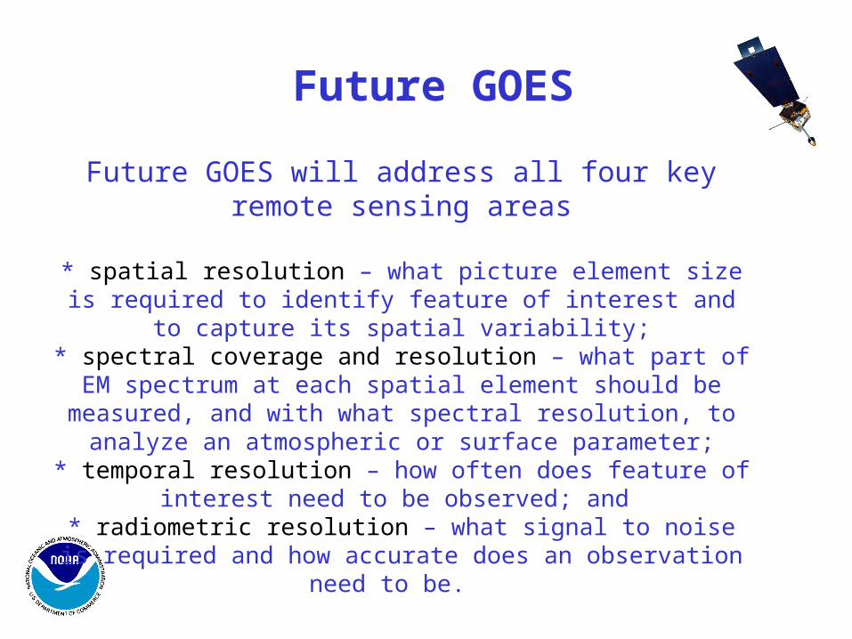
GOES Sounder Spectral Bands: 14.7 to 3.7 um and visible
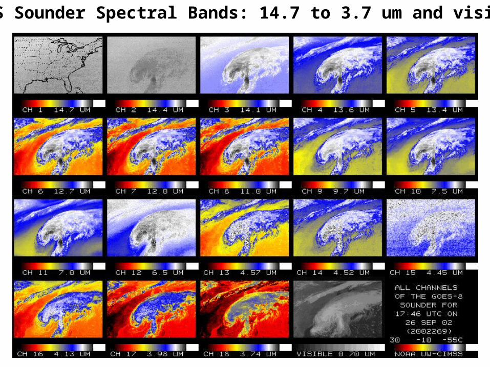
Record Earliest Tornado at Milwaukee, WI on 8 Mar 2000
• The GOES-8 Sounder monitors important precursors to the event.
moist axis
dry slot(dark areas)
Retrieval correctly subtracting moisture aloft (within the mid-level dry intrusion)
Retrieval correctly adding moisture in the lower
levels (within the moist axis)
GOES Retrieval
First Guess
(S.E. WI)
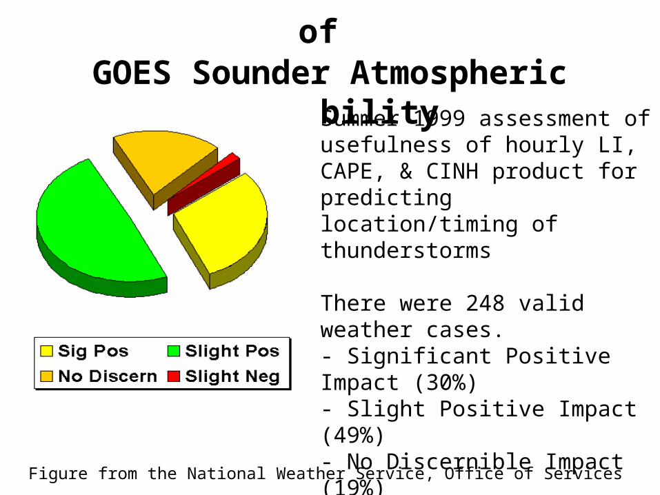
NWS Forecast Office Assessment of GOES Sounder Atmospheric Instability
Summer 1999 assessment of usefulness of hourly LI, CAPE, & CINH product for predicting location/timing of thunderstorms
There were 248 valid weather cases.- Significant Positive Impact (30%)- Slight Positive Impact (49%)- No Discernible Impact (19%)- Slight Negative Impact (2%)- Significant Negative Impact (0)
Figure from the National Weather Service, Office of Services

Global High Spectral Resolution Observations from AIRS 20-July-2002 Ascending LW_Window

Water Vapor 6.7µm Band (Low vs High Spectral resolutions

AIRS observations of tropical storm Isadoreon 22 Sept 2002 @ ~19:12-19:18 UTC
~999 1/cm radiances
Brightness temperature spectra

GIFTSGIFTS
4-d Digital Camera:4-d Digital Camera:
•
Horizontal:Horizontal: Large area format Focal Plane detector Arrays
Vertical:Vertical: Fourier Transform Spectrometer
Time: Time: Geostationary Satellite
New Technology for Atmospheric Temperature, Moisture, & Winds
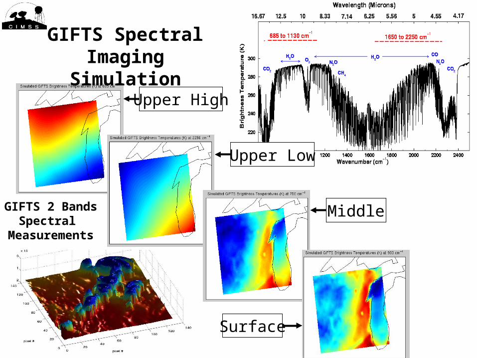
GIFTS 2 BandsSpectral
Measurements
GIFTS Spectral Imaging Simulation
Upper High
Upper Low
Middle
Surface
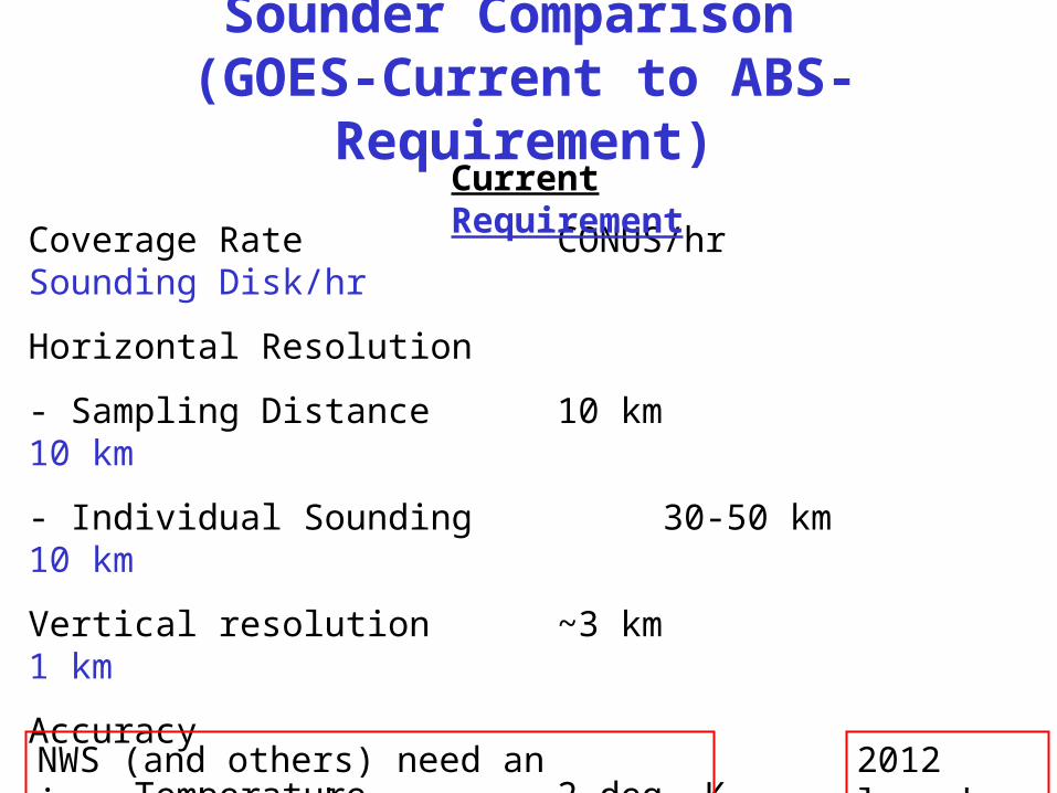
Sounder Comparison (GOES-Current to ABS-Requirement)
Coverage Rate CONUS/hr Sounding Disk/hr
Horizontal Resolution
- Sampling Distance 10 km 10 km
- Individual Sounding 30-50 km 10 km
Vertical resolution ~3 km 1 km
Accuracy
Temperature 2 deg. K 1 deg. K
Relative Humidity 20% 10%
Current Requirement
2012 launchNWS (and others) need an improved sounder
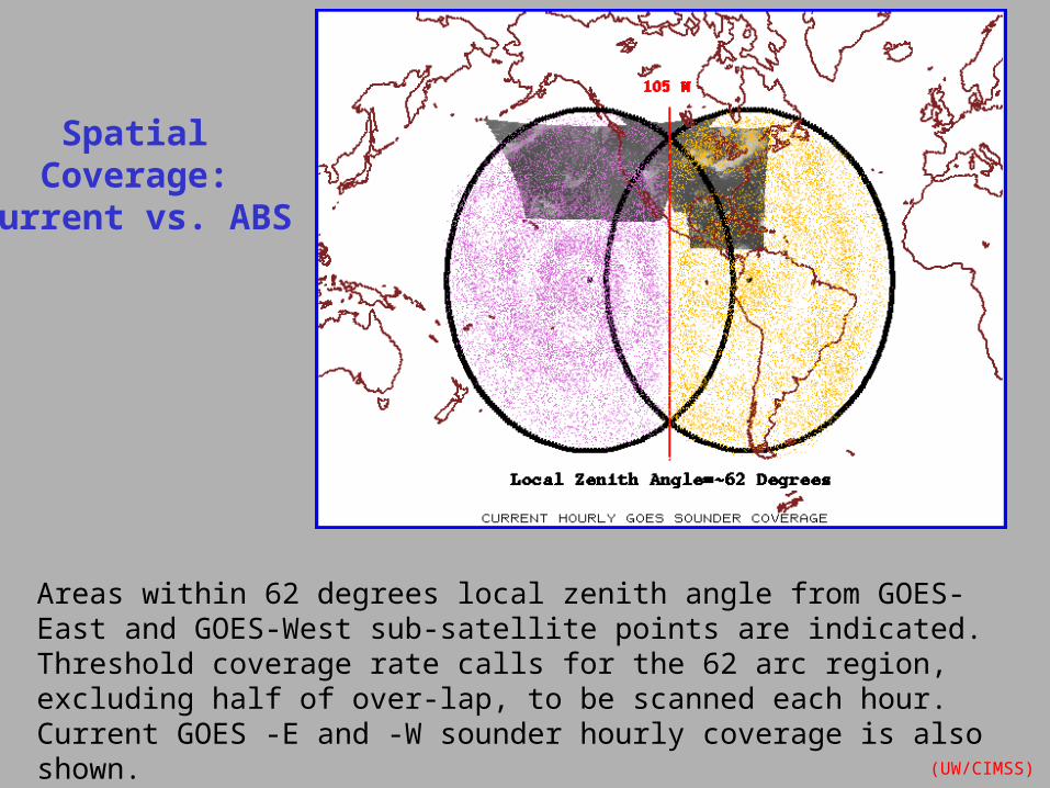
Areas within 62 degrees local zenith angle from GOES-East and GOES-West sub-satellite points are indicated. Threshold coverage rate calls for the 62 arc region, excluding half of over-lap, to be scanned each hour. Current GOES -E and -W sounder hourly coverage is also shown.
SpatialCoverage:
Current vs. ABS
(UW/CIMSS)
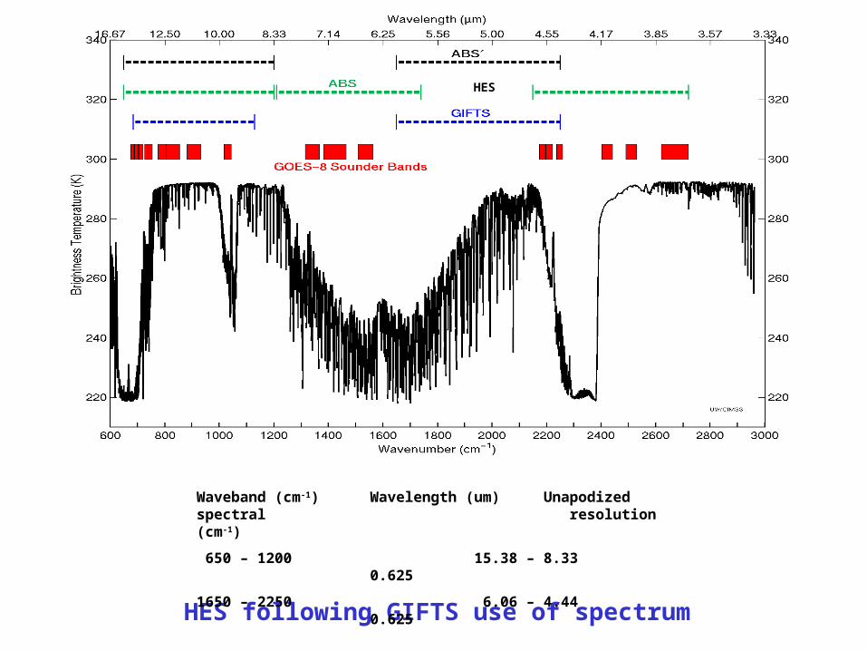
HES following GIFTS use of spectrum
HES
Waveband (cm-1) Wavelength (um) Unapodized spectral resolution (cm-1)
650 – 1200 15.38 – 8.33 0.625
1650 – 2250 6.06 – 4.44 0.625
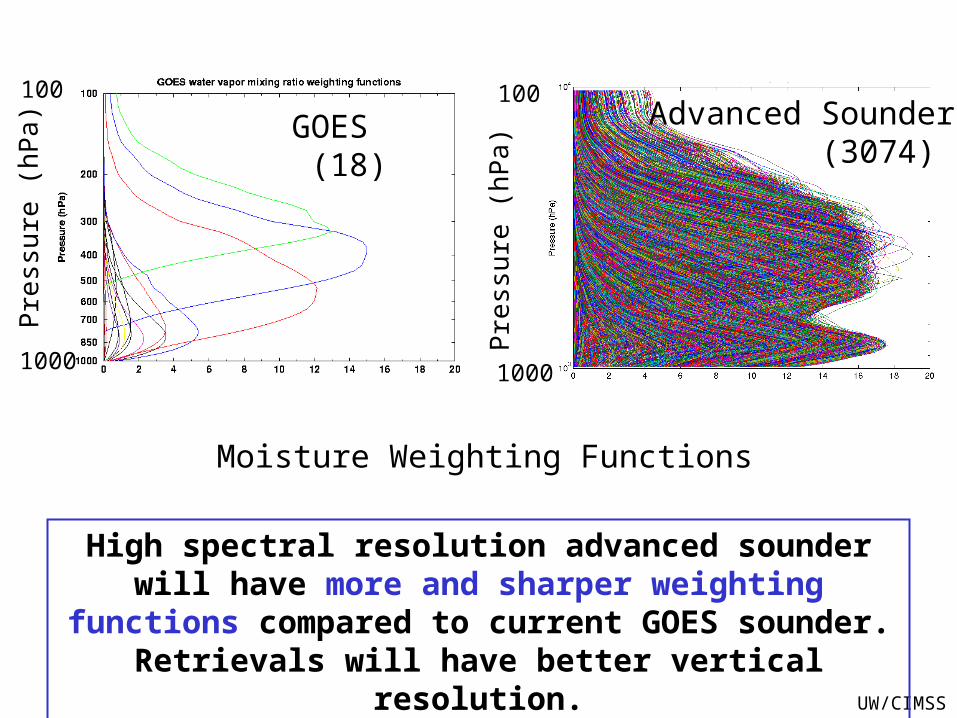
Moisture Weighting Functions
Pre
ssur
e (h
Pa)
Pre
ssur
e (h
Pa)
Advanced Sounder (3074)
GOES (18)
1000 1000
100 100
UW/CIMSS
High spectral resolution advanced sounder will have more and sharper weighting functions compared to current GOES
sounder. Retrievals will have better vertical resolution.
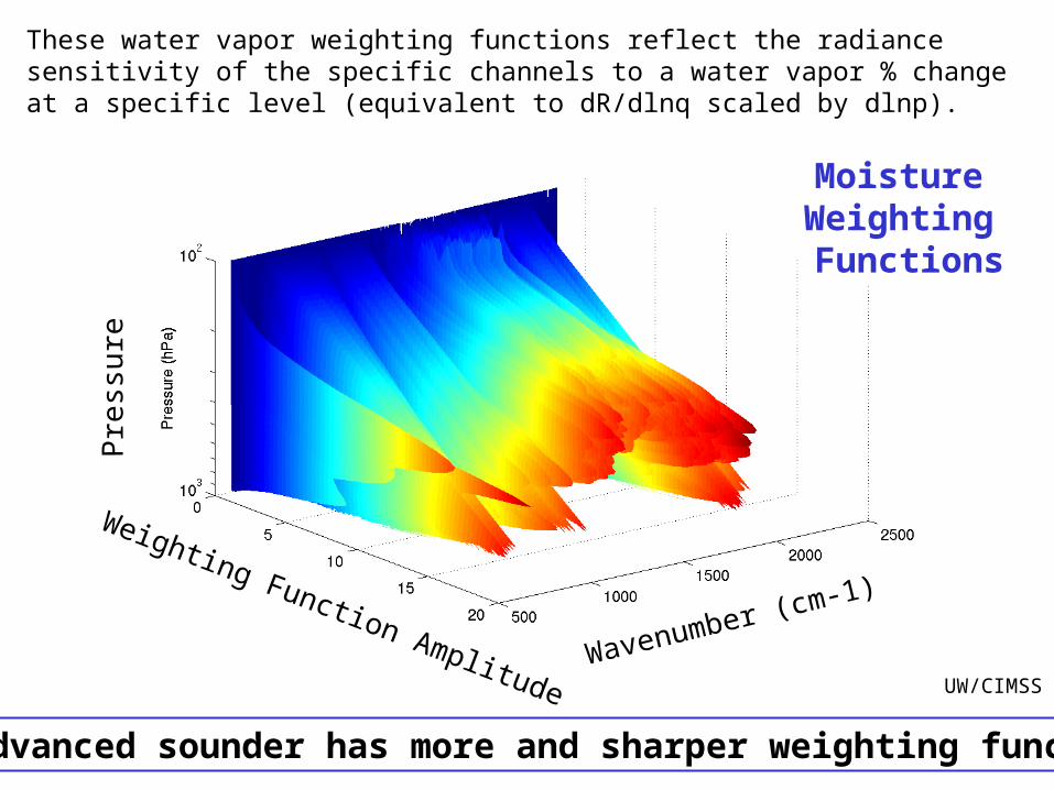
The advanced sounder has more and sharper weighting functions
UW/CIMSS
These water vapor weighting functions reflect the radiance sensitivity of the specific channels to a water vapor % change at a specific level (equivalent to dR/dlnq scaled by dlnp).
Moisture Weighting Functions
Pre
ssur
e
Weighting Function AmplitudeWavenumber (cm-1)

Simulations of Low vs High Spectral Resolution Retrievals Geo-I gets <1 K rms for 1 km T(p) and <10% rms for 2 km RH(p)
Temperature
Moisture
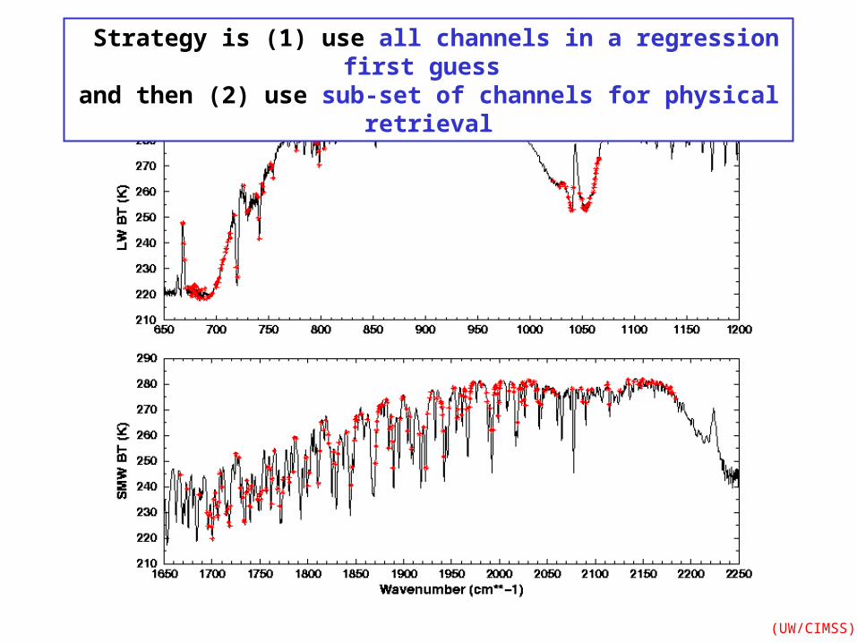
Strategy is (1) use all channels in a regression first guess and then (2) use sub-set of channels for physical retrieval
(UW/CIMSS)
Strategy is (1) use all channels in a regression first guess and then (2) use sub-set of channels for physical retrieval
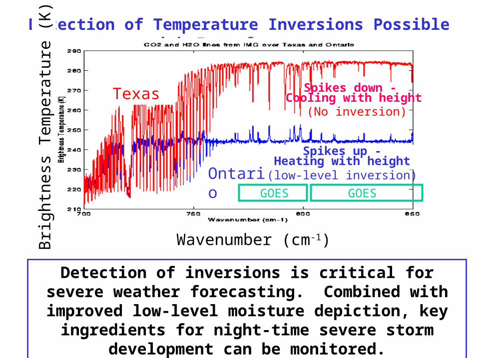
Detection of Temperature Inversions Possible with Interferometer
Detection of inversions is critical for severe weather forecasting. Combined with improved low-level moisture
depiction, key ingredients for night-time severe storm development can be monitored.
Spikes down - Cooling with height
Spikes up -Heating with height
Texas
Ontario
Bri
ghtn
ess
Tem
pera
ture
(K
)
(low-level inversion)
(No inversion)
GOESGOES
Wavenumber (cm-1)
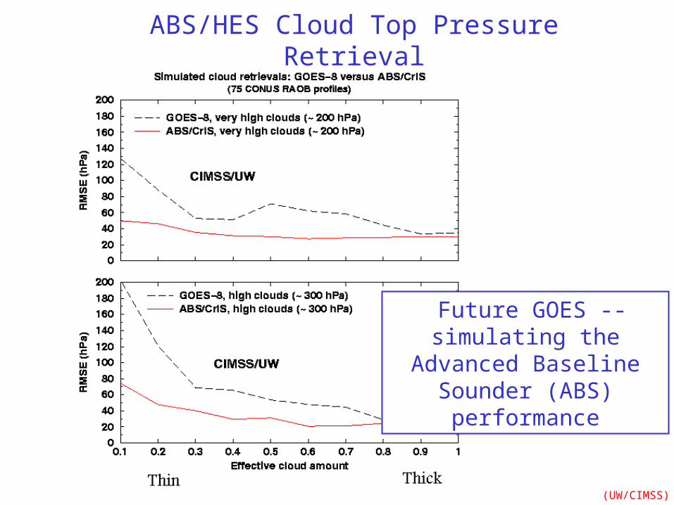
Future GOES -- simulating the Advanced Baseline
Sounder (ABS) performance
(UW/CIMSS)
ABS/HES Cloud Top Pressure Retrieval
HES addresses NWS Imager concerns by: • scanning faster - temporal sampling improved - more regions scanned• adding spectral resolution - to improve the vertical resolution of the retrievals
Simulations show that the HES addresses NWS requirements for improved cloud, moisture, and surface products.
Every product that is being produced from the current GOES Sounder will be improved with data from the HES!
New products will be possible, especially when combined with higher temporal and spatial information from the ABI.
Summary -- HES