THE HADRIANIC AQUEDUCT OF CORINTH - ASCSA · THE HADRIANIC AQUEDUCT OF CORINTH (WITH AN APPENDIX ON...
55
THE HADRIANIC AQUEDUCT OF CORINTH (WITH AN APPENDIX ON THE ROMAN AQUEDUCTS IN GREECE) (PLATES 66-76) 66 ERSONALLY, in the rank of the three most magnificent Roman works through L which the size of the supremacy of the Roman Empire is best manifested, I place the aqueducts, the paved roads, and the sewers not only because of their utility but also because of the sumptuous expenses they incurred." Dionysios of Halikarnassos (3.67) summarizeswhat an aqueduct representsin three notions: Roman greatness, utility, and lavish expenses. The construction of an aqueduct drew upon Roman technical progress, making it a characteristic Roman construction that contributed to the creation of an urbs Romana. This does not mean that the Greeks were unaware of aqueducts, the Archaic aqueduct on Samos and the Peisistratid aqueduct at Athens being two illustrious examples, but aqueducts did not achieve monumental dimensions or great diffusionuntil the Empire. THE LITERARY EVIDENCE The Hadrianic aqueduct of Corinth ranks high among the imperialpublic worksin Greece as evidenced by the travelerPausanias,who mentions it twice: 1 1 This paper does not claim to cover the subject and its various issues in all details. Such a presentation would exceed the limits of an article. I presented a brief notice of the remains in Lolos 1990-1991. Pausanias' quotations follow Teubner's edition (Rocha-Pereira,ed.), and Frontinus' translated quotations are taken from Evans 1994. I am deeply indebted to a number of people for their various contributions. This study grew out of my M.A. thesis, submitted in May 1992 at the University of the Sorbonne, under the supervisionof Professors Rene GinouvEs and Philippe Bruneau. My instructorin the Helleniki Epigraphiki Hetaireia, Dr. Yannis Pikoulas, suggested the subject to me, taught me how to conduct a field survey, and was an unfailing source of support and guidance through all stages of the work. My professors in Berkeley, Ronald S. Stroud and Stephen G. Miller, kindly offered to read the English manuscript and made crucial comments. Greta Vollmer willingly offered her time to proofread and edit the text. Marc Landon, a recent Ph.D. of the University of California at Berkeley,shared with me his great knowledge of the Corinthian water supply and bath complexes and pointed out some necessary revisions. Shawna Leigh, who is studying the Hadrianic aqueduct at Athens, was always available to answer my questions. Andreas Kilimiris, civil engineer, and Marios Kitsikopoulos,geologist, contributed much to corresponding matters. I greatly benefited from conversationsI had with Dr. Charles K. Williams and Dr. Nancy Boukidis. Mrs. Heleni Magou, chemist of the National ArchaeologicalMuseum of Athens, offered to analyse samples of mortar. Philippos Zoidis, professor of engineering, provided me with the necessary technical support. The architects Jeff Burden and Ruben Santos drew the maps and figures for the text. At the last stage, the corrections and comments of the anonymous readers for Hesperia led to many essential improvements. This project could not have been carried out without the substantial help and guidance of the local inhabitants along the major course of the aqueduct; among them, special thanks go to Nicolas Elias from Kionia (Stymphalia), Thanasis Asimakopoulosfrom Tourkobrysi (Nemea), PanayotisKalomoiris from Hesperia 66.2, 1997 American School of Classical Studies at Athens is collaborating with JSTOR to digitize, preserve, and extend access to Hesperia www.jstor.org ®
Transcript of THE HADRIANIC AQUEDUCT OF CORINTH - ASCSA · THE HADRIANIC AQUEDUCT OF CORINTH (WITH AN APPENDIX ON...

THE HADRIANIC AQUEDUCT OF CORINTH (WITH AN APPENDIX ON THE ROMAN AQUEDUCTS IN GREECE)
(PLATES 66-76)
66 ERSONALLY, in the rank of the three most magnificent Roman works through L which the size of the supremacy of the Roman Empire is best manifested, I place
the aqueducts, the paved roads, and the sewers not only because of their utility but also because of the sumptuous expenses they incurred." Dionysios of Halikarnassos (3.67) summarizes what an aqueduct represents in three notions: Roman greatness, utility, and lavish expenses. The construction of an aqueduct drew upon Roman technical progress, making it a characteristic Roman construction that contributed to the creation of an urbs Romana. This does not mean that the Greeks were unaware of aqueducts, the Archaic aqueduct on Samos and the Peisistratid aqueduct at Athens being two illustrious examples, but aqueducts did not achieve monumental dimensions or great diffusion until the Empire.
THE LITERARY EVIDENCE
The Hadrianic aqueduct of Corinth ranks high among the imperial public works in Greece as evidenced by the traveler Pausanias, who mentions it twice: 1
1 This paper does not claim to cover the subject and its various issues in all details. Such a presentation would exceed the limits of an article. I presented a brief notice of the remains in Lolos 1990-1991. Pausanias' quotations follow Teubner's edition (Rocha-Pereira, ed.), and Frontinus' translated quotations are taken from Evans 1994. I am deeply indebted to a number of people for their various contributions. This study grew out of my M.A. thesis, submitted in May 1992 at the University of the Sorbonne, under the supervision of Professors Rene GinouvEs and Philippe Bruneau. My instructor in the Helleniki Epigraphiki Hetaireia, Dr. Yannis Pikoulas, suggested the subject to me, taught me how to conduct a field survey, and was an unfailing source of support and guidance through all stages of the work. My professors in Berkeley, Ronald S. Stroud and Stephen G. Miller, kindly offered to read the English manuscript and made crucial comments. Greta Vollmer willingly offered her time to proofread and edit the text. Marc Landon, a recent Ph.D. of the University of California at Berkeley, shared with me his great knowledge of the Corinthian water supply and bath complexes and pointed out some necessary revisions. Shawna Leigh, who is studying the Hadrianic aqueduct at Athens, was always available to answer my questions. Andreas Kilimiris, civil engineer, and Marios Kitsikopoulos, geologist, contributed much to corresponding matters. I greatly benefited from conversations I had with Dr. Charles K. Williams and Dr. Nancy Boukidis. Mrs. Heleni Magou, chemist of the National Archaeological Museum of Athens, offered to analyse samples of mortar. Philippos Zoidis, professor of engineering, provided me with the necessary technical support. The architects Jeff Burden and Ruben Santos drew the maps and figures for the text. At the last stage, the corrections and comments of the anonymous readers for Hesperia led to many essential improvements.
This project could not have been carried out without the substantial help and guidance of the local inhabitants along the major course of the aqueduct; among them, special thanks go to Nicolas Elias from Kionia (Stymphalia), Thanasis Asimakopoulos from Tourkobrysi (Nemea), Panayotis Kalomoiris from
Hesperia 66.2, 1997
American School of Classical Studies at Athensis collaborating with JSTOR to digitize, preserve, and extend access to
Hesperiawww.jstor.org
®

272 YANNIS A. LOLOS
XpYVCL U 7cOxxat c ev &v& tinv i6oXLv 7 OELV-r=Vt to-caav &-e &cpO6vou fovro, OGYLOLV Ma&ro, xat 8 '
o3aoLXeu 'A ptav6o &c'nyayev &x E2uwicpy5Xou, ... 2.3.5
e'rLtv iv -Y-t E-ructpoaLv 7tTy', xoat &Tc6 -rta6)tY 6JS&Jp PaaXe6q MAptav6 KoptvOtLoL nycayev &q tr)v 7no'Xv. 8.22.3
These are the only explicit references made by ancient writers to a Roman aqueduct in the Greek peninsula; not surprisingly, then, in studies relevant to imperial building activity in Greece, the Hadrianic aqueduct is always mentioned.2 Pausanias' information, however, is limited to a simple mention of the work and its initiator, with nothing said concerning, for instance, its position, its constituent parts, its precise date, or how long it took to build. The accounts of early travelers can to some extent supplement the ancient information, although they must be used with care. Among the seven who refer to the Hadrianic aqueduct, only Pouqueville and especially Miliarakis describe it in some detail, whereas the others mention it only very briefly.3 Pouqueville, who in his books almost always uses the word aqueduct in the plural, writes: "Cet empereur (Hadrien) y avait fait conduire (to Corinth) celles ("les eaux") d'une source considerable voisine au Stymphale, au moyen d'aqueducs que leurs ruines font encore reconnaltre sur la ligne de montagnes de la Sicyonie a travers lesquels il decrit une courbe de pres de quarante milles, a cause des sinuosites du terrain" (V, p. 318). Miliarakis, in turn, furnishes the most complete description of the course of the aqueduct (cf. Fig. 1):
From Stymphalos, Hadrian brought water to the city of the Corinthians. In many places remains exist of a huge aqueduct having, according to the most plausible measurements, a length of 100 km. This aqueduct, having received the waters of the Stymphalian Kephalari, passed through the tunnel of Siouri to the Skoteini valley from where, after having traversed the upper reaches of the village of Platani, it reached the village of Gymno, and from there down slightly to the stream of Inachos in the direction of Malandreni, at a place called Belanidia, from where, through the pass of Tretos, it entered the valley of Kleones; then, it traversed the village of Agios Basileios, in order to reach Corinth through the Paloukorachi mountain. The water of this aqueduct would flow at times inside channels on the surface of the ground, and at times inside elevated channels supported by arcades whose remains can still be seen nowadays.4
Gell, who mentions the aqueduct very briefly, has nevertheless left us valuable testimony. Near the village of Kionia he spotted arches of the Hadrianic aqueduct: "On the other side of the water, near the village of Zaraca, the arches of an aqueduct erected by Hadrian to convey water to Corinth are visible."
Overall, these testimonia, however valuable they might be, are limited to a more or less general description of the course of the aqueduct and a vague localization of remains.
Koutalas (Corinthia), and Vasilis Bisbiroulias, a topographer from Corinth, who first inquired extensively into the Stymphalian line in the early 1970's. Finally, the realization of the project would have been impossible without the constant financial support of my parents and the assistance of my brother Perikles, my faithful companion throughout the Corinthian landscape.
2 The most recent works mentioning the Hadrianic aqueduct include Engels 1990, p. 77, and Alcock 1993, pp. 124-125.
3 Gell 1817, p. 148; Pouqueville 1826-1827, IV, p. 462, V, pp. 185, 318; Gell 1823, p. 384; Leake 1830, p. 243; Curtius 1851, p. 206; Vischer 1857, p. 498; Bursian 1868-1872, p. 38; Miliarakis 1896, p. 156.
4 Translation of the original Greek text is by the author.

THE HADRIANIC AQUEDUCT OF CORINTH 273
Furthermore, they cannot be taken at face value, given the uncertainties and the errors they often contain. For instance, two of these descriptions, those of Leake and Pouqueville, are inaccurate; Leake states that the emperor Hadrian constructed an aqueduct twenty miles long with the intention of carrying the water of Stymphalos to the Corinthian fountains (1830, p. 143). It happens that the actual length of the aqueduct is nearly three times that given by Leake. Pouqueville, on the other hand, saw eight large arches near Hexamilia, which the local inhabitants assured him were the remains of the "aqueducts of Hadrian" (1826-1827, V, p. 185). Once again, research has proved that the course of the aqueduct has no connection with the village of Hexamilia or its vicinity. Miliarakis exaggerated the length of the aqueduct, estimating it at 100 instead of 85 km. In other words, these testimonia merely provide indications and cannot by any means constitute trustworthy evidence for an archaeologist.
Topographical research, through both a thorough study of maps of the Army Service (scale 1:50,000 and, for certain areas, 1:5,000) and a field survey, has guided this study; this is the only valid means for gathering data concerning the remains and locating correctly the route of the aqueduct, as well as raising and at times solving the problems it presents. Moreover, this was not the only aqueduct to supply Corinth, and consequently only by walking its course can confusion be avoided.5 My survey showed that the aqueduct runs a distance of approximately eighty-five kilometers from Stymphalos to Corinth, partly underground and partly exposed over arches and low supporting walls.
THE COURSE OF THE AQUEDUCT6
The mountainous landscape between Stymphalos and Corinth accounts for the big south- ward curve and many sinuosities of the course for the water throughout its length (Fig. 1). Thus, a distance which does not exceed fifty kilometers as the crow flies required almost
5 In the case of aqueducts of "open type", water would flow by gravity; in other words, the water in the channel would progressively lose height from its starting to its terminal point. Thus, by walking its downward course, one is able to sort out other potential channels located higher or much lower than the aqueduct under investigation. Six segments of aqueducts are known in the vicinity of Ancient Corinth. Two have been spotted by the author: a water channel near the monastery of Agios Nikolas of the village of Mapsos (Fig. 1, at "a") and a second one at a place called Sykionas, near the village of Spathobouni, still functioning (Fig. 1, at "b"). A tunnel was spotted by Scranton near Penteskouphi and erroneously interpreted as part of the Hadrianic aqueduct (Fig. 1, at "c"): Morgan 1937, p. 552; Wiseman 1978, p. 82, fig. 105. Two more sections of aqueducts have been discovered on the northeastern slope of Acrocorinth (Fig. 1, at "d" and "e"; see note 19 below). One more channel has been found on both banks of the ravine east of Agios Georgios (not marked on Fig. 1; see note 19 below). On the other hand, the arched bridge found by Oscar Broneer over the ravine of Kakotheka, southwest of the village of Penteskouphi (Wiseman 1978, p. 82), is earlier in date, Classical or Hellenistic, and, as recently shown, part of an ancient road (see Stroud forthcoming; see also Pikoulas 1995, pp. 33-35, 301).
6 The letters A-K correspond to the sections into which the topographical map (Fig. 1) is divided. These letters introduce the corresponding description in the text. The map includes almost all the toponyms mentioned. On the other hand, it does not include the 69 points where I spotted the aqueduct and which are listed in the inventory published in Lolos 1990-1991. With the limited space available, all this information would have cluttered the map and made it less clear and less useful. Maps at a smaller scale (1:50,000), section by section, are required for this purpose and will accompany the final publication.

A Z i reia
~I'Drza Parl
Dhal rncea Lake tY
o0
Apelauros 4 Nemea
PFata . A(ra
FiG. 1. Course of the aqueduct: ca. 1: 150,000 (Army Geograph'ical Service [P T E]

THE HADRIANIC AQUEDUCT OF CORINTH 275
Ancient Corinth
Anapto0sa.-d
<eStesk0o-P Soloios
A NiVotaoS
Spathh ni 9
KouA
f~~~~~~~~~~~~hl odl l
Ancient Nenmea H Chs St oSO
psili Radii1
course of the aqueduct

276 YANNIS A. LOLOS
eighty-five kilometers to traverse. The aqueduct, which started from a spring at the village of Driza, on the southeast slope of Zireia and at an altitude of ca. 620 m, crossed the north- ern part of Lake Stymphalos and came out at the Skoteini valley through a tunnel piercing the northern side of Mount Apelauros. A second tunnel, opened at the ridge of the hills of Tsoukana and Alonaki, allowed the aqueduct to continue its course through the village of Platani and, from there, run along the flank of Pharmakas to reach the village of Gymno. From there, it continued its southeastern course, skirting Megalobouni and then, traveling in a northeasterly direction, reached Mount Stroggylo and passed just southeast of Ancient Nemea in order to continue in an easterly direction. It skirted the flanks of the mountains south and southwest of the village ofAgios Basileios and reached this village as it proceeded toward Chiliomodi, where it described a curve in a northwestern direction, toward Mount Spathobouni. From there it advanced north-northeast, on the slopes of Prophitis Ilias and Gerothanasi, to reach Ancient Corinth at an altitude of approximately 190 m.
[A] The water source for the aqueduct is located on the flank of Mount Kylini (KuX jv1) or Zireia (Zr5pem), more precisely of Tsepi (Tare'), as the inhabitants of Driza (Ap'Cxo) call the mountain at the foot of which their village is built (P1. 66:a). This source, consisting of a group of springs, is the most abundant of those supplying Lake Stymphalos.7 The springs extend over 360 m, at altitudes of 612, 618, and 621 m above sea level. The collecting basin is not extant today, but the subterranean channel is preserved beginning about 100 m from the spring.8 I spotted the masonry rubble (previously reported by Hector Williams9) belonging to the foundation of the aqueduct in the northern part of the lake, running southeast. As we have already seen, Gell (1817) refers to the arches of an aqueduct built by Hadrian "on the other side of the water, near the village of Zaraca." "The other side of the water" is the northern side of the filled-up lake, and Zaracas (Zpocpxo&g) is the modern-day village of Stymphalia (to the north of Driza). I believe that the arches must have stood between the place where the water channel disappears (at ca. 400 m from the source) and the tunnel. The difference in altitude between these two points, almost fifteen meters and too great a drop for a run of less than three kilometers, would have required the erection of arches in order to regulate the water flow and to protect it from the occasional innundation of the northern part of Lake Stymphalos.10 If this is so, the remains of the foundations of the aqueduct and square stone blocks found at this part of the lake could be traces of the opus arcuatum supporting it. The arched wall must have incorporated parts of an earlier
7 There are three groups of springs supplying the Stymphalian lake: the springs of Kionia (Kt6vta), which supply the Hadrianic aqueduct, of Doussia, and of Kastania; for the hydrology of the lake see Papadimos 1979, pp. 161-163.
8 Remains of the water tower must have disappeared even before 1900. Galanis, who offers a brief description of the aqueduct in his short study on Stymphalia, has no reference to such a structure (1901, pp. 38-39).
9 H. Williams 1984, p. 186; AR 1982/1983, p. 24; AR 1983/1984, p. 21. Williams describes an "unusual double water channel, one line at ground level and the other on arches whose foundations remain" (1984, p. 186). The statement is confusing: there is indeed a water channel at ground level next to the Hadrianic line, but it is a drainage channel earlier than the Roman aqueduct (see Knauss 1990, p. 44). There was only one aqueduct channel in the area, which ran on arches.
10 The altitude at the entrance of the tunnel at Siouri is calculated to be +606.60 m (Mantzikos 1955, p. 1).

THE HADRIANIC AQUEDUCT OF CORINTH 277
dam, perhaps Mycenean. Jost Knauss recognized traces of masonry of Mycenean style and speculated that they were used as a substructure to the Hadrianic conduit. Knauss also argues that the curve of the aqueduct within the Stymphalian basin is due to the curve of the earlier dam and that otherwise the aqueduct would have crossed the lake on a straight line. I find this hypothesis attractive but withhold final judgment until the alleged dam is excavated and more of it is known. 1
[B] Through a tunnel widened in 1881 in order to drain the lake and later used for the passage of Bochaikos Chandakas (BoxocxLx'c Xavocxcoq), the modern aqueduct to Bocha, the aqueduct emptied into the Skoteini (ExotretLv) valley.'2 It then proceeded toward the hill of Alonaki (AXcavxL), and remains of its foundations are to be seen in two places there, parallel to the modern aqueduct. The rivus subterraneus is visible on both banks of the Psari ('&pL) River. It crossed the stream on top of a bridge (P1. 66:b) of large dimensions (L. 22 m, H. 6 m, W 2.60 m) and emptied into the area of Platani (IkoroivL), at a place called Pournarodiaselo (IIoupvoypo8tLaeXo), through a second tunnel, also widened in modern times (P1. 67:c).13 The aqueduct then proceeded in a southern direction along the hillsides of Tsoukana (Taoux&vcx) and Tsepournia (TaetoupvL&), to loop north-northeast along the foot of Kaka Tsiroupia (Kocx& ToLpoi'mo) and around Xerobouni (epopouvL). From there, the channel turns southward, skirting Ntourmiza (Ntou'ppiLCc) above the village of Gymno (rupvo). From Pournarodiaselo to Gymno, the aqueduct is mostly subterranean and for a considerable distance has been destroyed by a modern country road. 14 Among the four bridges still preserved, the one crossing the stream of Drampala (LSpackt&X) is the most important: W 2.60 m, H. 1.90 m, L. (original) 9 m.
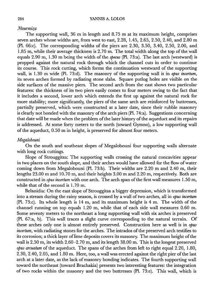
[C] The aqueduct skirts Ntourmiza, in the direction of Megalobouni, and its support- ing wall with seven arches of monumental dimensions is preserved on the east slope of the mountain (L. 36 m, H. 8.75 m, W 2.90 m; P1. 66:c).'5
[D] The limestone and the natural concavities of Megalobouni (Meyocxopou5vL) defined the kind of construction used for the aqueduct in this sector: rock cuttings (xocxocxoveq) and long supporting walls follow one another for a distance of four kilometers. Skirting
" Knauss 1990, pp. 42-44. The dam would have blocked the western side of the oC Vtey6&X XLt,vvj of Pausanias (8.22.3), which Knauss places along the eastern extremity of the Valley of Stymphalos. Salowey very recently endorsed this interpretation and the existence of an earlier dam along the line of the aqueduct (Salowey 1994, pp. 84-86, fig. l:a, b).
12 The date of the operation (1881) is taken from Galanis' monograph (1901, p. 67); for details on these modern operations see p. 289 below.
13 From that point on, the modern aqueduct follows a different, more northern route. 14 For the destruction of the aqueduct in modern times see p. 299 below. 15 Aupert (1984) mentions enpassant these seven arches in his reference to the northern aqueduct at Argos,
but he maintains that it is "sans doute" a different system than the one servicing Corinth. Again, with reference to the same Argive aqueduct, he writes: "Mais, paradoxalement, les vestiges peut-8tre attribuables a un aqueduc vers Corinthe, I'aqueduc de Gymno?, celui du mont Strongylo etudie par Biers ne peuvent etre ceux d'une construction d'Hadrien, tandis que ceux de l'aqueduc Nord le sont tr6s certainement" (Aupert 1989, p. 731). These statements show how dangerous it is to write about topographical issues without having the opportunity to become familiar with the topography itself Nevertheless, Aupert understood that the Gymno arches are not part of the northern aqueduct of Argos.

278 YANNIS A. LOLOS
the Strouggitsa (E-TpouyyLUraa) slope, the aqueduct followed a northeastern route in the direction of Ancient Corinth, traversing Belanidia (Be)XcvL8&) and the north slope of Stroggylo (SEpoyyuX6), where rock cuttings were also spotted (P1. 67:a, b, d).
[E] It crossed the branch of the Xerias (E'L6pt) River, in the direction of Tourkobrysi (Toupx6f3ppuar), on top of a bridge of monumental dimensions and construction technique (H. 11.20 m, L. 42.50 m, W 2.50 m; P1. 66:d).16
[F] At Tourkobrysi the rivus subterraneus followed a northern course toward the Ale- potrypes (AXet6xputg) and Rachi Mantzorou (P&Xv MavxC6pou) hills, but along this stretch most of it is now destroyed by the new highway to Tripolis (P1. 67:e). The section left intact includes the only tank found throughout the whole route of the aqueduct. Of considerable dimensions (40 x 11 Im), it is apiscina limaria, a tank where the water impurities settled (P1. 76:c, e).
[G] From the area ofDerbenakia (A3ppevaxLa), where the underground water channel appears in two places on the Rachi Mantzorou (P1. 68:a), the aqueduct headed east in the direction of the village of Agios Basileios along the slopes of Trikorpho (Tp'xoppo), Psili Koumaria (TX'I Kouap1pct), and Daphnias (AcaypvLoc), on top of a long supporting wall, while rock cuttings have been spotted on the north flank of Psili Koumaria and again at the entrance to the village of Agios Basileios (P1. 68:b, d). The bridge crossing the stream of Psili Koumaria preserves parts of its abutments on each bank (P1. 68:c). Its total length was originally 1 1.50 m, while its width measures 2.20 m. The aqueduct soon disappears as one enters the village, only to reappear at its eastern limit, where the foundations and part of the right lateral wall are preserved (P1. 68:e).
[H] The passage of the aqueduct from the area of Stalio (aBXLo6), in a northeasterly direction toward Chiliomodi (XLXLo,u6&t) and well to the north of the village of Klenia (KXevMca), is subterranean. Throughout this whole area, it would have crossed eight deep ravines, only three of whose corresponding bridges were spotted. The most impressive remains are those of the ravine at Stalio called Kabourorema (KaIoup6ope,u), where the piers of the arch are preserved to a maximum height of 7.80 m. What shows today is the filling of rough rubble mixed with simple clay mortar, the facing having disappeared (P1. 69:a, c). Furthermore, the subterranean channel appears in two places at Stalio (P1. 69:b). The aqueduct, now heading north, passed between the mountains of Prophitis Ilias (HIpoyp5vn HXLcai) and Paloukorachi (HlaXoux6opaXv), in the direction of the village of Koutalas (KouTocXa'). The remains of the wall of the aqueduct exist on the banks of the ravine coming down from Paloukorachi. The aqueduct then passes under the village of Koutalas and emerges again on the south flank of Arbanitis (ApPf3vU"rj), where its supporting wall with one arch is preserved: L. 16 m, H. 2.20 m, W 2.60 m (P1. 69:d).
[I] Remains of the rock cuttings and of the foundations of the aqueduct are preserved in many places on the west slope of Arbanitis. The ravine of Skouroukli (Exoupou'xXr), between Arbanitis and the mountain of Prophitis Ilias, was crossed by a substantial bridge
16 The bridge is first mentioned by A. G. Russel (1924, p. 45), followed by Ernst Meyer (1941, p. 280), G. Roux (1958, p. 163), and W K. Pritchett (1969, p. 224, pl. 66). It is published in detail by William Biers (1978; see pp. 286-288 below).

THE HADRIANIC AQUEDUCT OF CORINTH 279
whose north wall, the best preserved, measures 3 m in length by 6 m in height (P1. 70:a). From the ravine, the aqueduct traces a more northerly course, and its channel appears at about eighty meters north of the Skouroukli stream. At Sykionas (Euxdwoa), east of the village of Spathobouni (E7raOoj3o6vL), the third tunnel of the aqueduct (at an approximate depth of twenty meters) is cut by the new highway to Tripolis (P1. 70:b). Farther north, on the banks of the ravine of Smyrtorema (EvupT6pe,oa), the floor and part of the side walls of the channel are preserved. A recent fire on the mountain of Gerothanasi (IrTpoOcv&Cna) exposed many parts of the whole channel, which originally, covered with earth, skirted the western slope in the direction of Penteskouphi (LkvtCaxo6pl) village, where I saw remains of it as well, on the right edge of the road leading to the village church (P1. 70:c, d).
[ Part of the supporting wall of the aqueduct is still visible on the abrupt western flank of Kastraki (KcastpoxL; P1. 71 :a). 17
The channel reappears in two places on the northwestern slope of Acrocorinth, near the Church of Agia Marina ('AyLo Mtp'Lvc), while its last remains, including its floor and part of its left wall, have been spotted on the western flank of the Anaploga (AvaczraXyc or Avocnvoy&) ravine, already intra muros (P1. 71 :b, c), at an altitude of 191 m. 18
Between the village of Anaploga and Ancient Corinth, located some 400 meters to the northeast, no traces of either the channel itself or the central tank into which it would have emptied have been found.19
The existence of a central basin was imperative, as a "center" for division and direction of the incoming water to several parts of the city and as a place for storage of the surplus. In Greece, central tanks of aqueducts have been found in a number of cities, such as Argos, Athens (both ofthe Hadrianic period), Gytheion (Peloponnesos), Dion (Macedonia),
17 This wall is located some thirty meters below the tunnel piercing the west side of Kastraki. This is the tunnel mentioned by Morgan and Wiseman. It belonged to another hydraulic system that probably had the same final destination (see note 5 above).
18 The measurement was taken in the summer of 1993 by David G. Romano and his team (the Corinth Computer Project).
19 Segments of two water channels have been found on the northeastern slope of Acrocorinth, one 400 m east of the Sanctuary of Demeter and Kore, the other on the hill of Agios Georgios (marked on Fig. 1 as "d" and "e"). I owe this information to Marc Landon, who kindly showed me parts of his Ph.D. thesis (December 1994). Landon raises the possibility that the first conduit, discovered in 1965, might be a subbranch of the Hadrianic system; he has some reservations, given the absence of additional evidence and the very existence of a second conduit, discovered in 1938, apparently not connected with the Hadrianic line. Therefore, it remains at least possible, according to Landon, that a local source could have supplied both conduits. A third water channel is located farther to the east, on both banks of the ravine east of the Church of Agios Georgios, and at an altitude of approximately 162 m. The channel, built with rubble stone, cement, and scattered tiles, is visible in two places: a short stretch (4 m) at the western side of the ravine and a longer stretch (38 m) traceable along its eastern bank. A few meters to the north of this longer stretch one can see the underground conduit through small holes accidentally created in its roof. In addition, part of the masonry of the bridge is preserved within the rema. I was unable to measure the width or the height of the channel, since only its exterior side wall is exposed, and for the present its connection to the main Hadrianic line remains questionable: the channel is too far to the east and at a much lower altitude than the last certain segment of Hadrian's aqueduct (at Anaploga). Nevertheless, the location of this channel is potentially significant with respect to the setting and extension of the Roman and post-Roman settlement of Corinth. I am grateful to H. Conrad Stroud, who drew my attention to this unknown construction and helped me find it.

280 YANNIS A. LOLOS
Dimitrias (Thessaly), Nikopolis (Epiros), and the Cretan cities of Chersonisos and Basiliki. In the South Stoa of the Forum at Corinth, a tank located at the end of a row of Archaic monolithic columns was interpreted by Broneer as a basin of an aqueduct, possibly the aqueduct in question.20 This hypothesis, often criticized and rejected primarily because of the dimensions of the tank, cannot be so easily discarded. It is clearly not the castellum divisorium of the aqueduct itself, but we cannot exclude the existence of secondary reservoirs deriving from the central collecting basin, which is normally located at a much higher altitude. Secondary castella, sometimes raised on top of brick piers, are known from Pompeii and elsewhere, including Nikopolis.21 On the other hand, information regarding the water supply of the Corinthian bath complexes is so far almost nonexistent. No canalization system of the water sources for the baths has yet been discovered owing to the modern village built on top of them.
THE CONSTRUCTION OF THE AQUEDUCT
SERVICE RoADs
During construction of the aqueduct a network of roads connected to it would have been necessary for the transport of labor and materials. Even after construction was completed, access to the aqueduct was necessary for its maintenance. Wheel ruts parallel to the Hadrianic aqueduct at Argos have been reported for Tziristra and survive in Douka Brysi.22 I was unable to find similar evidence, either wheel ruts, rock cuttings, or retaining walls, that would indicate the presence of such a network. Some such arrangement would be expected in hard soil, such as, for example, the limestone of Megalobouni. According to local information, however, traces of wheel ruts parallel to the channel could once be seen in Alepotrypes, but unfortunately the modern highway connecting Corinth to Tripolis overlapped this section, causing any ancient traces to disappear. Yanis Pikoulas came to the same conclusion after having investigated the area with Ronald S. Stroud in July 1994.23 According to Pikoulas, wheel ruts were also reported for the area between the villages of Platani and Gymno, on the slopes of Kaka Tsiroupia and Xerovouni, parallel to the water channel. Once again, the opening of a road joining the two villages apparently destroyed any traces of it.24
20 Corinth I, iv, p. 155. For the central basins of the cities mentioned above see the relevant entries in the Appendix.
21 Hodge 1992, pp. 291-294. For the two secondary reservoirs of the aqueduct at Nikopolis see the Appendix, p. 304 below. An additional problem concerning the connection of this colonnade with the Hadrianic aqueduct is the date of its erection. It has been convincingly shown that the columns were removed from the cella of the Archaic Temple of Zeus, and, according to the excavators, their reuse could be dated in the first half of the 1st century after Christ (Robinson 1976, p. 237, note 106). If this is so, then the water line must be a later addition to the colonnade, the primary use of which remains unknown; alternatively, the colonnade supported a water channel from the beginning, obviously one earlier than the Hadrianic aqueduct. The whole issue needs further investigation.
22 Pikoulas 1995, pp. 150-153, pls. 61-64. 23 Ibid., p. 63. 24 Ibid., pp. 154-157.

THE HADRIANIC AQUEDUCT OF CORINTH 281
_E~~~~~~~~~~~~~~~~~~~~~~~~~~~~t
0
,~~~~~~~~~~~~~~~~~~~~~~~~~~~~~~~~~~~~~~U,
0
-~~~~~~~~~~~~~4
-10.50 1.1 2 0 50
0,03 0.03
Fie,. 2. The aqueduct at Skoteini: the specus
THE SPECUS
The vaulted channel (specus) of the aqueduct, built 'in rubble masonry with clay mortar as the binding material, had more or less constant dimensions along its ent'ire route: 1.00-1.20 m wide (with the exception of the rock cutting at Ntourmiza, 1.30 m wide) and 1 .40-i1.60 m high (Fig. 2; Pls. 69:.b, 70:d, 71 :d). The diameter of the vault could reach 1. 30-1.40 m, wh'ile the projection of 'Its side walls toward the interior varied between 0.10O and 0.22 m. In most places the vault 'is constructed of stone slabs laid radially; but in others it was simply built w'ith rubble and mortar7, in a manner similar to the rest of the channel. On the interior face of the vault, the outline of the wooden scaffolding boards on the concrete surface is evident. The "quarter rounds", built in the two bottom corners of the channel in order to make it watertight, limited the width of the bottom of the specus to 0.80-0.90 m. These 'impervious linings, not always preserved, are about 0.20 m high.

282 YANNIS A. LOLOS
The lateral walls measure 0.80-0.85 m in height and are entirely coated, as is the bottom, in opus signinum, the thickness of which varies anywhere from 2 to 4 cm, the average being 3 cm. This variation suggests that different crews were involved in the construction of the specus. The fact that the mortar consists in some places of two layers and in others of three argues in favor of this suggestion. On the bank of the Psari River in the Skoteini valley, for example, the coating of the channel comprises two layers, a coarse, gray under coating ca. 2.5 cm thick, with pebble inclusions, and a smaller, reddish outer coating ca. 5 mm thick (Fig. 2, P1. 71 :d). In the section from Smyrtorema to Penteskouphi (I-K; P1. 71 :b), the mortar (2.6 cm thick) includes three layers, the outermost, extremely smooth and without any inclusions, being thinner than a centimeter. The external dimensions of the channel are more or less constant: the average thickness of the vault is on the order of 0.30-0.40 m, while the thickness of the side walls is 0.50-0.60 m. In some sections, however, the thickness of the lateral walls reaches 0.80 m, particularly on top of bridges. The average thickness of the bottom is 0.50-0.60 m. Thus, the aqueduct overall measures 2.40 m in average height and 2.20 m in average width. These measurements have been taken in the subterranean or, in places, half-covered channel. It is preserved in this manner for a considerable distance and in good condition in the Skoteini valley, on the banks of the Psari River; on the slopes of Tsoukana, Tsepournia, Mesobouni, and Megalobouni between Belanidia and Brachakia; at Tourkobrysi, Rachi Mantzorou, Panagorachi, and Stalio; on the slopes of Gerothanasi; and at Agia Marina, near the village of Anaploga.
Nowhere is the channel preserved intact in the open, in other words, on top of a bridge or a supporting wall. All that remains is its bottom and, in places, its lateral walls to a height of a few centimeters. The vertical rock cuttings, which form the base of the aqueduct and one or both parts of its side walls, were for the most part cut into hard stones (limestone, for instance), around Megalobouni and on the slopes of Stroggylo and Trikorpho. The length of these katatomes varied from one to six meters, while their height varied from a few centimeters to more than a meter. Their width does not exceed 1.20 m, which corresponds to the width of the channel (Pls. 67:d, 68:d, 72:a, b). There was an obvious effort made to erect the channel on hard and steady bases, that is, on the natural rock, and to build the upper parts of the side walls and the vaulted roof.25 This masonry part is preserved only at Sykionas. The plaster coating of the interior sides of the rock faces, used to reduce surface friction and to ensure waterproofing, is preserved in at least two places (P1. 72:b). The fact that the masonry of the channel was not uniform but formed partly of rubble and partly of the natural rock hastened its erosion.
The vault of the conduit was pierced, at more or less regular intervals, by inspec- tion holes, which allowed cleaning and general maintenance. An inspection manhole, rectangular in section, was spotted on the slope of Tsoukana, at Katebises (Kocxe'Pf3ev). Its external dimensions are 1.06 x 0.70 m, while the interior measures 0.72 x 0.65 m (P1. 72:c). This is the only observed puteus constructed over the channel, but there are undoubtedly others filled with earth and not visible and yet others totally destroyed. Built channel shafts (as opposed to tunnel shafts), reported in connection with other aqueducts
25 Constructed channels which incorporate leveled rock surfaces are quite common: cf., for example, the channel on the slopes of Isioma Hill and elsewhere, near Nikopolis (Doukellis et al. 1995, p. 214).

THE HADRIANIC AQUEDUCT OF CORINTH 283
in Greece, are all rectangular in shape, such as in the aqueducts of Philippoi (Thrace), Nikopolis (Epiros), and of the Cretan cities of Gortys and Kissamos. Shafts tapering toward the interior are also reported for the aqueduct at Nikopolis.26
Before raising questions concerning the masonry and the mortar used, I would like to point out the existence of two structures obviously meant to regulate the water flow. One, observed at Tsoukana, a few meters before the puteus mentioned above, shows a lowering of the vault by ca. 1.20 m, preceded by a considerable narrowing of its section (P1. 72:e). The vaulted, narrowed section is 0.60 m high (p.H.), 0.50 m wide, and 0.40 m long. It is possible that we have here a system of fall according to which the water would abruptly lose height. Similar installations are encountered in France and elsewhere.27 The situation at Tsoukana, however, is different: there is no inspection manhole above the "barrier", while a narrowed stretch is not reported in connection with known cascades from elsewhere. This arrangement needs more investigation, including the clearing of the bottom of the channel at this point. The second structure was observed at Brachakia (BpoCXLOxLc), east of Megalobouni. It includes an enlarging of the section of the conduit for a length now unknown, owing to the fact that the aqueduct was destroyed in that area by the new highway to Tripolis (P1. 72:d). Are we to suppose the existence here of an overflow chamber where the water, piled up against the area smaller in cross section, would brim over through an opening in the roof? This is impossible to confirm as the roof of the channel at this point is no longer preserved.28
The mortar serving as a binding material and as a coating to increase the impervious- ness of the conduit belongs to the category of lime mortars containing a high proportion of magnesium oxide. The binding agent is calcium oxide, and the filling material is silica. The red tint is mainly due to the iron oxide, which has been added by means of brick fragments. The rate of alumina is low and the proportion of lead almost nonexistent. The chemical analysis of three samples from the coating of the channel taken from three dif- ferent areas showed variation, particularly in the percentage of calcium oxide (CaO), silica (SiO2), and iron oxide (Fe203), which indicates that various (local) crews were involved in the operation. In the same way, all materials used have local origins, extracted from the nearest sources. Thus, the limestone rubble of the arches near Gymno comes from the very mountain where the arches were built, namely, from Ntourmiza.
THE SUPPORTING WALLS
The supporting walls, with or without arches, appear in three areas: on the east slope of Ntourmiza southeast of Gymno; on the south and southeastern slopes of Megalobouni; and on the north slopes of Psili Koumaria and Daphnias to the west of Agios Basileios.
26 For the rectangular shafts refer to the relevant entries in the Appendix. A shaft observed over the Kokkinopilos tunnel at Nikopolis measures 1.85 m2 at the exterior end and 0.90-0.95 m2 on the interior (Doukellis et al. 1995, p. 216).
27 The aqueducts of Lyon (Craponne), Autun, and Beaulieu (Aix-en-Provence) have series of cascades. See Hodge 1992, p. 161.
28 Such overflow devices do occur, for example, in the aqueduct of Gier (Lyon): Hodge 1992, pp. 95, 104, fig. 56.
284 YANNIS A. LOLOS
Ntourmz'a The supporting wall, 36 m in length and 8.75 m at its maximum height, comprises
seven arches whose widths are, from west to east, 2.28, 1.45, 2.65, 2.50, 2.40, and 2.80 m (P1. 66:c). The corresponding widths of the piers are 2.30, 3.50, 3.40, 2.50, 2.00, and 1.85 m, while their average thickness is 2.70 m. The total width along the top of the wall equals 2.90 m, 1.30 m being the width of the specus (P1. 73:a). The last arch (westward) is propped against the natural rock through which the channel cuts in order to continue its course. This rock cutting, which forms the continuation westward of the supporting wall, is 1.30 m wide (P1. 73:d). The masonry of the supporting wall is in opus incertum, its seven arches formed by radiating stone slabs. Square putlog holes are visible on the side surfaces of the massive piers. The second arch from the east shows two particular features: the thickness of its two piers easily comes to four meters owing to the fact that it includes a second, lower arch which extends the first up against the natural rock for more stability; more significantly, the piers of the same arch are reinforced by buttresses, partially preserved, which were constructed at a later date, since their rubble masonry is clearly not bonded with the masonry of the arch piers (P1. 74:a). Suggestions concerning that date will be made when the problem of the later history of the aqueduct and its repairs is addressed. At some forty meters to the north (toward Gymno), a low supporting wall of the aqueduct, 0.50 m in height, is preserved for almost four meters.
Megalobouni On the south and southeast slopes of Megalobouni four supporting walls alternate
with long rock cuttings. Slope of Strouggitsa: The supporting walls crossing the natural concavities appear
in two places on the south slope, and their arches would have allowed for the flow of water coming down from Megalobouni (P1. 73:b). Their widths are 2.20 m and 2.40 m, their lengths 23.00 m and 10.70 m, and their heights 3.00 m and 2.20 m, respectively. Both are constructed in opus incertum with one arch. The arch span of the first wall measures 1.50 m, while that of the second is 1.70 m.
Belanidia: On the east slope of Strouggitsa a bigger depression, which is transformed into a stream during the rainy season, is crossed by a wall of two arches, all in opus incertum (P1. 73:c). Its whole length is 14 m, and its maximum height is 4 m. The width of the channel running on top equals 1.20 m, while that of each side wall measures 0.60 m. Some seventy meters to the northeast a long supporting wall with six arches is preserved (P1. 67:a, b). This wall traces a slight curve corresponding to the natural terrain. Of these arches only one is almost entirely preserved. Construction here as well is in opus incertum, with radiating stones for the arches. The intrados of the preserved arch testifies to its corrosion; a thick layer of lime deposits covers its masonry. The maximum height of the wall is 2.50 m, its width 2.60-2.70 m, and its length 38.00 m. This is the longest preserved opus arcuatum of the aqueduct. The spans of the arches from left to right equal 2.20, 1.80, 2.30, 2.40, 2.05, and 1.80 m. Here, too, a wall was erected against the right pier of the last arch at a later date, as the lack of masonry bonding indicates. The fourth supporting wall toward the northeast (toward Brachakia) presents two interesting features: the integration of two rocks within the masonry and the two buttresses (P1. 73:e). This wall, which is

THE HADRIANIC AQUEDUCT OF CORINTH 285
14.00 m long, 3.50 m wide, and 2.40 m high at its maximum, shows a clear curvature; it is delimited at its two extremities by the natural rock and marked by a buttress in the middle. A second buttress is built at the right end against the supporting wall and the rock. Between these two buttresses, two arches are constructed, 2.25 m high and 0.80 m wide. The width of the supporting wall reaches 2.50 m, of which 1. 15 m correspond to the water conduit and 0.70 m to its lateral walls.
Agios Basileios Low substructiones alternating with katatomes run along the north slope of Psili Koumaria
and of Daphnias, east of Agios Basileios, and to a distance of more than 500 meters (Pls. 68:b, d, 74:b). In this case, the supporting walls have modest dimensions, rarely exceeding one meter in height, and consequently do not have arches except where surface storm-water flow would have required it. The rubble masonry of the supporting wall of the aqueduct can be spotted even inside the village, below the modern cemetery.
THE BRIDGES
Frontinus, in his treatise on the aqueducts of Rome, uses the word opus arcuatum for both the arched supporting walls and the bridges, without making any distinction between the two. Technically speaking, both are constructed in the same way, and their difference is purely functional: the arches of the supporting walls serve primarily to make the structure lighter, whereas the arches of the bridges are related to the spanning of gullies and rivers, large or small.29 Twenty-two bridges can now be counted along the entire route of the aqueduct, a number clearly smaller than the number orignally constructed. An examination of Figure 1 reveals more than seventy places where bridges were needed but have been destroyed or are seriously damaged and thus hardly distinguishable. Among the bridges I have noted, four have considerable dimensions: those of the Skoteini valley, of Stroggylo, of Stalio (Kabourorema), and of Skouroukli. The rest have smaller dimensions: their height may vary between 1.50 m and 4.00 m, while their original lengths only occasionally reach more than 12 m. The width of the bridges equals 2.50-3.00 m with the exception of those of Belanidia and Smyrtorema, which are 4.00 m and 3.40 m wide, respectively. All are of one tier except the bridge of Stroggylo, which has two. The majority of them have, or seem to have had, only one arch, and only three have or had more: the bridge of Belanidia comprises two arches, the bridge of Kabourorema had three, and the Stroggylo bridge has six at its upper level. With the exception of those of Stroggylo and of Skoteini, which will be discussed separately, the bridges are constructed in opus incertum, a factor contributing to their relatively accelerated deterioration. Indeed, in many cases the facing of the bridges, of worked rubble and lime mortar, has disappeared, and all that now remains is the internal rough rubble masonry, occasionally containing a very weak mortar; the tall piers of the Kabourorema bridge provide a good illustration (P1. 69:a, c). It
29 This, obviously, is a simplification; many factors underlie the distinction between the two forms: thus, the arches of a "supporting wall" primarily serve to "relieve" the weight of a massive structure but also save in material and allow the passing of water, animals, and humans below them, especially when they were extended for many kilometers. Similarly, the arches of a "bridge" are a response to the currents of the stream below, but they also help to lighten the bridge.

286 YANNIS A. LOLOS
0 10
FIG. 3. The south face of the bridge of Stroggylo (Biers 1978, fig. 2; R. L. Holzen)
is not only the original width and length of the bridges that are not always preserved; their height is also rarely original, since the traces of the channel crossing on top are no longer distinct. There are a few cases, however, where even the side walls of the channel are visible on the top surface (deck) of the bridge. This is true of the bridges of the Skoteini valley, of Drampala, and of Smyrtorema. In the latter two cases, one side wall of the specus of each is preserved, at a height of 0.40 and 1.30 m, respectively. The entire arches of the Stroggylo bridge, one arch of the bridges of Belanidia, and the arch of a low bridge at the Tsoukana hill (at a place named Kamaritsa) are in place. For the others, only the spring of the arch (at Drampala or at Skoteini), or the piers, or only part of the abutments against one or the other bank of the river are still in situ.
Stroggylo The bridge on the north side of Mount Stroggylo, running west to east, is undeniably
the most monumental and best-preserved structure of the aqueduct (Fig. 3, Pls. 66:d, 75:a).30 This bridge, examined in detail by William Biers,31 is built in opus quadratum and on two levels. Its maximum height reaches 11.20 m, its length 42.50 m, and its width 2.50 m. The channel, whose borders can be seen on the deck of the bridge, is 1.20 m wide. The maximum height of the first level is 5.00 m, and the span of the arch at its center is 2.20 m. The second level, 6 m high, includes six arches, the piers of which have an average height of 2.20-2.30 m; their widths from west to east are 1.50, 1.90,
30 The Ephoreia of Antiquities of Nauplion, which undertook a consolidation operation in 1974, con- tributed to that preservation.
31 Biers 1978. Biers described the bridge, giving exact measurements and a drawing. But the fact that he focused exclusively on the bridge, without seriously inquiring about the hydraulic system to which it belonged, did not allow him to answer the question of the water source raised by the title of his article. With the evidence available to him, he tended to give a later date for the construction and doubt its connection with the Stymphalian aqueduct altogether. For the dating issue discussed in his article see note 32 below.

THE HADRIANIC AQUEDUCT OF CORINTH 287
1.86, 2.35, 1.86, and 1.36 m, respectively. The five corresponding piers are on average 2.70-2.80 m thick. The masonry is the most spectacular aspect of this structure and indicates that careful attention was paid to it. The lower level and the piers of the second level are constructed in irregular ashlar, masking a core in opus caementicium. Many reused blocks, originally belonging to two or more buildings, were incorporated in the masonry; some of them can be easily recognized: an engaged column 0.45 m in diameter (P1. 75:b), parts of an entablature with threefasciae, a frieze band with dentils above, parts of an epistyle and a frieze with their moldings preserved, and four column drums of different sizes, among others. This allows us to imagine the existence of local (Phliasian) shrines in the vicinity (presumably in ruins at the time), since the transport of these blocks from afar, when quarries such as the Drimoni ones were nearby, would have been unnecessarily expensive. The only arch of the bottom level has thirteen stone voussoirs. The arches of the upper level, on the other hand, are built with a double row of radiating bricks. Successive registers of brick occur in the masonry above the opus quadratum. The first of these is located at the spring line of the arches, a second one runs just above the arches, a third between these two, while the fourth register, partially preserved, runs on top, immediately below the rubble masonry of the bottom of the conduit. Between those brick registers are interposed bands of rubble with worked rubble facings, the whole constituting an opus mixtum in alternating bands. The bricks, all square pedales 0.27 m on a side on the average, have a mean thickness of 3.3 cm, with a corresponding average thickness of the mortar joints of 3.1 cm.32 Putlog holes can be seen in the masonry of the upper level,
32 Based on the correlation in thickness between brick and mortar, Biers suggested the end of the 2nd or the beginning of the 3rd century as a possible date for the construction of the bridge. In doing so, he follows the dating criteria established by Ginouves based on the buildings at Argos (Ginouves 1972). At the same time, Biers acknowledges the insecurity of any date based on brick evidence given the rarity of post-Hadrianic brick constructions published so far, as well as the fact that Argos probably had its own brick industry. Financial constraints, which are generally considered to be the main reasons for the downward profile of the curve line of the coefficient of density between brick and mortar during the Late Empire, could also account for the prolific use of mortar in this aqueduct, where the cheapness of construction is evident. Furthermore, the considerable variation in the thickness of the bricks and of the mortar courses at Argos and even in the masonry of this bridge on Mount Stroggylo makes the use of the brick dating system confusing and of debatable value. According to the new data base established by Aupert (1990) for the Argive buildings, the minimum thickness of the bricks of the bridge on Stroggylo (2.8 cm) suggests a date after A.D. 350, whereas their maximum thickness (3.6 cm) suggests a Hadrianic or a 4th-century date, or one even later. Similarly, the minimum thickness of the mortar courses (1.25 cm) suggests a Hadrianic date, whereas its maximum thickness (4.3 cm) points to the late 4th century. Regarding their average thickness, both bricks (3.3 cm) and mortar (3.1 cm), as well as their resulting quotient (1.06: coefficient of density), suggest a late-4th-century date for the construction of the bridge. The possibility of later repairs, for example after the successive earthquakes of the second half of the 4th century (see p. 291 below), seems unlikely, since the upper level of the bridge presents a rather uniform structure. Jane Biers, in her study of the Roman bath on the Lechaion road, concluded that a comparison of the coefficient of density (brick/mortar) between that bath at Corinth and Thermes B at Argos is not satisfactory (Corinth XVII, p. 87). This is to say that there is certainly a general tendency over time toward a thickening of the mortar and a corresponding thinning of the brick, but the evolution is irregular and subject to local realities. I would suggest waiting to accumulate more archaeological data before deciding whether or not it is possible to establish a secure dating system, based on the relation between the thickness of the bricks and the mortar, that can be generally applied.

288 YANNIS A. LOLOS
;~~~~~~~~~~~~~~~~~~~~~~~~~tt . ,i t
s. X . 0 . " . *
,,,. jM ,
/~~~~~~~~~~~~~~~~~~~~~~~~~~~~~~~~~ vtw; ,'p'd
1Z~~~~~~~~~~~~~~~~~~~~~~~~~~~~~~~~~~~~s sy~rtI * .M'.9
i, .~. ." W
0 1.0 2.0 ':" .1'
Li'
FIG. 4. Perspective reconstruction of the bridge at the Skoteini valley
on both the north and south faces of the bridge. The last rubble band, corresponding to the bottom of the conduit, is only partially preserved.
Skoteini The bridge at the Skoteini valley, located 130 m north of the modern bridge of the
Bochaikos Chandakas, preserves neither its arch nor its original face (Fig. 4, P1. 66:b). It is built in opus incertum; its maximum height is 6 m, its total length 22 m, and its width 2.60 m, of which 1.20 m comprises the width of the conduit. The interest of this bridge crossing the Psari River lies not so much in its dimensions or in its relatively good state of preservation but rather in its annex structures on the north bank (P1. 74:c). Indeed, just to the left of the north pier of the bridge, I noticed two successive walls parallel to the pier and delimiting two parallel and contiguous structures (A and B), 2.60 m and 2. 10 m wide, respectively. The walls, today covered with earth and with their upper parts collapsed, are in brick, while the spaces between them are filled with rough rubble work. The masonry between the two brick walls is founded on irregular ashlar blocks that describe a n at its east corner. This foundation is 6.00 m long by 2.20 m wide on its east side (top of

THE HADRIANIC AQUEDUCT OF CORINTH 289
the n), and its height comes to 2.50 m. Structure A corresponds to a similar construction on the opposite (south) bank, of which only some rubble is visible today. We probably have here a bridge, contemporaneous to the aqueduct bridge, which would have been for the crossing of animals and people. By contrast, I have no explanation to offer for structure B, which is founded upon stone blocks. The ashlar part could have been the north pier of an earlier (Classical) wooden bridge, but on the opposite bank of the ravine there are no corresponding traces. Perhaps further examination of the remains will throw some light on the problem.
THE TUNNELS
The aqueduct included three tunnels over the course of its route: on the ridge of Mount Apelauros (called Siouri), at Alonaki (called Prathi), and at Spathobouni (at a place called Sykionas). The Siouri tunnel is cut partly through limestone and partly through marl; it measures 1.07 km in length, and its apex lies at a maximum of ca. eighty meters below the surface. The thick vegetation around its mouth made useful photography impossible. The Alonaki tunnel is much shallower, approximately twenty meters below the surface, and its length reaches 750 m (P1. 67:c).33 These two tunnels have had longer careers than the rest of the aqueduct. In 1881 a Greek company was given the right to drain the Stymphalian lake. The company engineer, an Italian named Degliabbati, decided to use the existing tunnel (Siouri) for the evacuation of the stagnant water. A few years later, in 1886, the company went bankrupt, and the operation was abandoned. At the turn of the century, in 1901, a law was passed concerning "the irrigation of the Corinthian plain from the Asopos river and the Stymphalian lake" (law BQKE9'). At this point both tunnels were used and integrated into the system of irrigation for Bocha (the area between Kiato and Lechaion), which has been functioning since 1911.34 Proposals for an enlargement of the section of both tunnels were brought forward in the 1950's in order to increase the discharge of water, but the precise nature and the extent of the completed operations are unrecorded. One could fairly assume that the 1881 works included deepening the tunnels, since the lake to be drained was at a lower altitude.35 The extent to which the tunnels were deepened remains unknown. In the early 1950's, the dimensions of the Siouri tunnel at the entrance were 1.50 x 1.90 m and at its exit, 1.60 x 2.50 m. The Prathi tunnel measured 1.60 x 1.80 m at the entrance and 1.60 x 1.40 m at the exit.36 Today, the height of the Prathi tunnel at both ends is over two meters. Consequently, the original dimensions and technical details of the tunnels can only be speculated upon. One could suppose, for example, that both had the average dimensions of the rest of the aqueduct, or their dimensions could be inferred from those of the third tunnel described below (one possible drawback to this line of reasoning would be the difference in soils). Three round, vertical inspection manholes were spotted, which undoubtedly have existed since Roman times, apparently originally with smaller diameters. These putei, constructed at regular
33 Length measurements taken from Mantzikos 1955, p. 1. 34 For this historical information see Tingarakis 1945, pp. 29-30, 38. 35 The single contemporary source explicitly stating that the Siouri tunnel was deepened for irrigation
purposes is the memoirs of Spiros Paganelis from his excursions in the Peloponnesos (1891, p. 66). 36 Mantzikos 1955, p. 1.

290 YANNIS A. LOLOS
distances (every 30-40 m), would have facilitated the digging of the tunnel and would have allowed its regular maintenance after that.37
The tunnel of Spathobouni is dug entirely in marl soil and preserves its original dimensions: 1.00 m. wide by 1.70 m high (P1. 75:d). A vertical inspection manhole, at present filled with earth, is also observable above it, some ten meters to the north. There must have been more of these manholes, but a portion of the tunnel was destroyed during construction of the highway from Corinth to Tripolis, leaving its exact length (and the number of manholes) undeterminable. Its depth (below the surface) is approximately thirty meters. The walls of the tunnel are not coated with plaster despite the fragility of the soil, but this is not so uncommon.38
SETTLING TANKs
The settling basins, a type of rectangular cistern constructed along the route of the conduit, served to secure the purity of the water conveyed but also to restrain the rate of flow when needed. These were typically standard parts of aqueduct systems, especially of lengthy ones. Of the two piscinae limariae on which information is available, I have actually seen only one, at Alepotrypes. A second one must have existed closer to the starting point of the aqueduct. Indeed, according to local tradition, at a place called Kamini (Ka.LLVL) on the slopes of Xerobouni above the village of Gymno, there was a cistern in brick masonry which the local people dismantled after World War II. The toponym is significant in this respect: the name Kamini was given presumably because of the brickwork in the side walls of the cistern. The construction of a basin at that location is justified by the fact that the gradient of the aqueduct in that section was close to 30 m/km, which clearly obliged the engineer to slow the impetus.39
To our good fortune, the new Tripolis highway, which between Tourkobrysi and Rachi Mantzorou followed the same route as the Hadrianic aqueduct, deviated for some 700 m at the place called Alepotrypes, where the only settling basin of the aqueduct can now be seen at 380 m altitude. The thick vegetation prohibited the examination of its interior, and I could only observe the long north rock cutting and its south wall, built in opus incertum (P1. 76:c, e). It measures 40 x 11 m, the width of its wall equals 1.70 m, and it is equipped with six buttresses on the exterior, each 0.90 m wide and at intervals of approximately seven meters. Considering the uniformity of the masonry, these buttresses must have been built at the same time as the wall they support. Similar buttresses prop the wall of the basin
37 The vertical shafts of the Kokkinopilos tunnel of the Nikopolis aqueduct are spaced 40 m apart (Doukellis et al. 1995, pp. 215-216), while those of the Athenian aqueduct are 35 to 37 m distant (see the entry in the Appendix below).
38 Compare, for example, the tunnel of the Sikyon aqueduct at Sesi or a tunnel discovered in 1991 in Piraeus, at the corner of Heroon Polytechneiou and Bouboulinas Street, both dug in friable soil and not showing any traces of plaster (see the corresponding entries in the Appendix below).
39 This figure (30m/km) is excessively large, and one wonders if any further arrangement, a subterranean cascade, for example, was also provided. Although there was no typical gradient for an aqueduct and dramatic variations are seen even within individual aqueducts according to the landscape, an overall profile between 1.50 m to 3 m/km is often attested. For a comprehensive discussion of the gradient of an aqueduct and of cascades built along its course, see Hodge 1992, pp. 160, 216-219.

THE HADRIANIC AQUEDUCT OF CORINTH 291
of the aqueduct at Dion.40 This basin served for the purification of the water, although this use can only be assumed until the interior has been cleared. The last filtering of the water was no doubt secured by the castellum divisorium of the aqueduct, above Corinth, which remains to be discovered.
REPAIRS OF THE AQUEDUCT
Consolidation work on the aqueduct, particularly of its supporting walls, has been detected in the arches of Ntourmiza and Belanidia. These repairs consist of buttresses in opus incertum propping up the piers of the arches and of lateral reinforcing walls. At Ntourmiza, two buttresses strengthen the piers of the second arch from the left. Of the two, the right-hand one is better preserved: 1.30 m in thickness and 3.40 m in original width (P1. 74:a). At Belanidia, two reinforcing walls can be seen in two places: The east end of the six-arch wall is strengthened by a wall 0.65 m thick (P1. 76:a). Some seventy meters farther east, a second wall required two bulky buttresses. The one located in the middle measures 1.50 (Th.) x 1.80 (W.) m, with a maximum height of 1.35 m (P1. 76:b). The second, at the east end, is 1.40 x 1.80 m. Reinforcement of aqueduct piers by means of buttresses and walls is common, including the outstanding examples of the aqueduct of Frejus in France (Les Arcs Bouteillkre) and the aqueducts at Rome.41 Wheler saw buttresses propping the piers of the aqueduct at Patras.42 When these buttresses were built later than the piers their dating is very difficult, given that an aqueduct, especially its exposed parts, needed frequent repair. In the case of the Corinthian aqueduct, determining the exact date of the repairs from the construction technique, mainly opus incertum, is not possible because this particular masonry style occurs during the entire Imperial period and up to modern times. Extensive destruction occurred in the Corinthia in the late 4th century as a result of two major earthquakes, in A.D. 365 and 375.43 The effect of these earthquakes on the aqueduct line is difficult to assess, but it is certain that the arches would have needed repair even before that date. Thus, at least in my mind, only historical data could provide some chronological hints or, better, a terminus ante quem for these repairs. The 5th century saw the decline of the city of Corinth at all levels and the abandonment of its bath complexes.44 It is fair, then, to assume that these repairs took place during the 3rd and 4th centuries,
40 See the Appendix under Thrace and Macedonia. 41 See Grenier 1960, pp. 45, 52; Ashby 1935, pp. 118, 119, 216; figs. 10-12, 21; Van Deman 1934,
pp. 105, 282, 315, fig. 1, pls. XXI, XLVI, LIII. 42 See the Appendix below. The situation observed in the row of piers at Archangelos near Nikopolis,
where two out of ten piers are doubled by two others, still lacks a satisfactory interpretation and can hardly be used here as a comparandum (Doukellis et al. 1995, pp. 219-220).
43 The earthquake of 365 is mentioned by Amm. Marcellinus (26.10.15-19) and by Georgios Kedrenos (Compendium historiarum 310), among others. The earthquake of 375 is mentioned by Zosimos (4.18). On the earthquakes of the first millenium in Greece, as elsewhere in the Mediterranean, see Guidoboni 1989. Damage caused in the Corinthia by these earthquakes is often archaeologically indicated (Corinth I, i, p. 147): the Captives Facade (Corinth I, ii, p. 88), the buildings along the central terrace (I, iii, p. 131), the colonnade of the West Shops (VIII, iii, p. 165), the theater (Williams and Zervos 1987, pp. 31-32), and buildings in the Sanctuary of Demeter (Stroud 1993, p. 73) are some of the structures that were seriously damaged by these earthquakes.
44 See pp. 297-298 below.

292 YANNIS A. LOLOS
in order to take care of both the natural deterioration of the exposed parts of the aqueduct after many years of service and possible damages caused by the earthquakes.
GEOLOGICAL EXAMINATION
Variation in the type of construction was often related to the nature of the soil on which the aqueduct was founded (Fig. 5). The tunnels, rock cuttings, and the erection of supporting walls were mainly in the limestone areas, as on the slopes of Megalobouni or of Stroggylo, for example. In contrast, marl and alluvium favored deep trenches and a subterranean course, as between Agios Basileios and Chiliomodi or at Brachakia. Occasionally, however, the librator seems not to have taken the nature of the soil into consideration. Compare the Tsoukana tunnel, cut through limestone, with the one at Spathobouni, cut in marl and lacking even an interior coating. Hybrid solutions are frequent, as the Siouri tunnel, situated partly on limestone and partly on alluvium, testifies. The same situation occurs in the Roman aqueduct at Nikopolis. The major part of the Kokkinopilos tunnel is dug through limestone, but its last 100 meters or so, through argillaceous soil.45 In the case of Corinth, it is more the morphology of the landscape, rather than the composition of its soil, that dictated the kind of construction used over the course of the aqueduct.
THE HISTORY OF THE AQUEDUCT AND ITS USE
THE INITIATOR AND THE DATE OF THE CONSTRUCTION
Pausanias attributes the construction of the aqueduct to the emperor Hadrian, and as the traveler visited Greece only two decades after the reign of Hadrian, there is no reason to doubt his testimony. Presumably Hadrian not only arranged for the financing of the project but also provided the requisite engineering support, in other words, appointed a hydraulic engineer or designer (librator vel architectus). Examples from Africa and Asia Minor show that such experts could not be found among local people.46 In other provinces it was the Roman army that was involved in the labor.47 In the case of Corinth, in the absence of an army stationed within the province, the crews involved in the construction of the aqueduct must have been composed of local people recruited from the different territories crossed by the aqueduct.
Often imperial benefactions followed the personal visits of the emperor to the con- cerned regions. This was obviously not always the case, but it is fair to assume that petitions of the local authorities concerning huge and extremely expensive projects would have been more effective if they were made to the emperor while he was on the spot. Both Cassius Dio (69.5.3; 9.1) and the Historia Augusta (17.8) betray the unprecedented lust of Hadrian for traveling and providing the cities of his Empire with monumental constructions, mainly of a utilitarian nature. We know that Hadrian visited the Peloponnesos at least twice,
45 Doukellis et al. 1995, pp. 215, 222-225. 46 Shaw cites two examples from North Africa and one from Nikomedia (1991, pp. 69-71). 47 See Fevrier 1983.

Ancient Corinth
+ 4 fN+
+ / -Arocorinth
+ 4 enteskouphi +9+ s+ +
Spathobouni i +
Lake Stymphal Os
j5 1 _ Nemea
P1atazi 'Chiliomodi
p ltaninglomerate
__ + *s ? s ~~~~~~~~%n. t 41r 41 gx%a - s e d F m e n t s~~~~~~~~~~~~~~~~~~~Z~-4
V7 seimestnts
FIG. 5. Geological map: 1:200,000 (Institute of Geological Studies [I r M E])

294 YANNIS A. LOLOS
in 124/5 and in 128/9.48 The emperor could thus have become personally acquainted with the issue of the Corinth water supply during one of his visits and have ordered the starting of the work upon his return to Rome. Thus, construction is likely to have begun in 125/6 or in 129/130.
Concerning the duration of the construction all we have is the reference of Pausanias, who mentions Hadrian alone as the initiator of the monument. If the work was left unfinished and was continued by Antoninus Pius, Pausanias might be expected to have mentioned it. Resorting to information derived from other aqueducts with reference to the duration oftheir construction is not particularly helpful, since duration depends not only on the dimensions and the quality of construction but also on the related landscape, the work- men engaged, and the available funds. If we consider the year 125/126 as the initial year of the work, then the operation did not exceed twelve years. In the second case (1 29/130) the maximum duration of the work would be limited to eight years.49 In any case, it is certain that when Pausanias visited the area the system was functioning, and this furnishes a terminus ante quem for the completion of the project: roughly the decade 150-160.5?
THE OUTPUT AND WATER ADMINISTRATION
Estimation of the daily output of the aqueduct involves, among other factors, knowl- edge of its hydraulic radius, particularly of the height the water occupied inside the con- duit, and the existence of a constant slope. In the case of the Hadrianic aqueduct, the section remains unknown and the gradient changes in certain areas. Consequently, the calculation of the output is, at best, appxroximate.51
48 The travels of Hadrian to Greece are still a matter of debate. His first visit in the Peloponnesos is attested by a number of inscriptions from Epidauros (IG IV2 88, 127, 383, 384, 389; AEpzgr 1974, 609) and Tegea (IG V ii 50, 51). This last inscription (IG V ii 51) helps to establish the exact date of Hadrian's first arrival in the Peloponnesos, namely, the year 124/5. Explicit testimonia for his "epidemiai" are also available from Sparta (IG V i 32b; SEG XI, 492, 630) and Troizen (IG IV 758). The date of Hadrian's second trip (128/9) is established by his letter to the Ephesians (SyA.3 838) and by epigraphical testimonia from Sparta (SEG XI, 492; IG V i 486) and Tripolis (IG V ii 28). Concerning the emperor's third trip to Greece, there is no mention of his coming to the Peloponnesos. Cassius Dio (69.11.1, 16.1-2), Eusebios (Fotheringham 1923, pp. 280-282), and the Historia Augusta (VH 13.1, 6), on the other hand, mention only two trips by Hadrian to Greece. For further discussion and bibliography on the subject see Follet 1976, pp. 113-116, Schwartz 1983, pp. 297-301, and Halfmann 1986, pp. 191-192.
49 These are the only secure chronological references we are fortunate enough to have. It is not yet safe to try to establish a more precise chronological framework, and we have seen that an attempt to do so by comparing the thickness of the mortar and the brick of the bridge of Stroggylo with similar numerical data from Argos is still dangerous (see note 32 above); the chronological indications provided by reused blocks in the masonry of the bridge of Strongylo are equally vague (see Biers 1978, p. 182).
50 The exact dates of Pausanias' travels in Greece are still a problem. Concerning the Corinthia, Puech argues, convincingly in my opinion, that Pausanias' arrival must be placed between ca. A.D. 152 and 161. For the relevant arguments see Puech 1983, pp. 37-38. I thank Professor Ronald Stroud for drawing my attention to this article.
51 We could divide the area between Stymphalos and Corinth into three major sections in relation to the gradient of the aqueduct: Stymphalos to Platani; Platani to Gymno; Gymno to Corinth, the gradient between Platani and Gymno being by far the highest. Again, more detailed measurements, this time by sections, must be taken into account in the calculations, which will give us more precise numbers.

THE HADRIANIC AQUEDUCT OF CORINTH 295
Here I use the Manning formula, the most widely used of all uniform-flow formulas for open-channel flow computation, owing to its accuracy and its simplicity of form: V = I/n x R2/3 x J1/2, where V is the water velocity depending on a coefficient (n) of roughness of the material (lime mortar), on the hydraulic radius of the aqueduct (R) and of its average gradient (J). The radius is the quotient of the area divided by the perimeter (R = S/P). The height of the water can be roughly estimated at 0.50 m, given that the lateral walls were 0.80 m high and the width of the channel equals 1.00-1.20 m.52 It could hardly be lower than 0.50 m, since the entire surface of the walls is coated with plaster, which suggests that the water level could occasionally reach the top of the lateral walls.53 The average gradient equals its altitude between Stymphalos and Corinth (620 -80 = 440 m) divided by the total length (?85 km) and comes to almost 5.2 m/km. This is a high figure, and comparison with the average gradient of the aqueducts at Nikopolis and Athens, 1.14 m and 2.00 m per kilometer respectively, is striking.54 The advantage of a high gradient lies in the large amount of water conveyed daily and the unobstructed course of the water within the conduit. The drawback is the relatively high speed of deterioration of the channel under the strong water pressure.
Thus, for R = 0.50/2.40 andV = 1.805, Q= 0.50 x 1.8 = 0.9 m3 /sec = 77,932 m3 /day, or approximately 80,000 m3/day.55 Today, such a daily output (80,000,000 1) would be sufficient for a population of at least 300,000 people.56 This calculation is made purely to show the capacity of such a water discharge in modern terms and does not by any means reflect the ancient situation. The baths and the numerous fountains of Corinth alone would have demanded millions of liters of water daily. We should also take into consideration the fact that the output was not uniform but could vary according to the season. According to a series of measurements taken in the 1940's, the output of the Kionia springs varied from 680 I/sec in November to 1,800 1/sec in May.57 In a period
52 That the water would normally fill half to two-thirds of the height of the channel is attested for some aqueducts (see Hodge 1992, pp. 224-226), including the aqueduct at Nimes (Fabre, Fiches, and Paillet 1991, p. 69). Roman engineers would have faced the possibility of subsequent thick lime deposits on the surface of the walls of the aqueduct, with a consequent increase of the water level inside the conduit. In addition, they must certainly have understood what is now a basic hydraulic principle, namely, that the best hydraulic rectangular section (i.e., the section providing the maximum conveyance) is half of the square, in other words, the width must be twice the depth. An estimated 0.50 m for the depth of the water in the Stymphalos-Corinth channel is precisely half of its minimum width (1 m).
53 The fact that there are many aqueducts with only part of their interior walls coated with hydraulic mortar indicates the sense of economy the Romans had, especially when financial means were limited. One should keep in mind that the plastering of the walls of an aqueduct was expensive and time-consuming, fine, manual work, trusted to skilled workmen (parietarii).
54 See also note 39 above. 55 Since, at least at this stage, the estimate of the water discharge of the aqueduct is at best approximate, I
prefer this round figure rather than a more "precise" one which would give an illusion of historical accuracy. 56 The water consumption per inhabitant today ranges from 150 to 250 1/day. It is worth noting here that
Quellenec's plan (see p. 300 below) was supposed to provide water enough for 250,000 people (Tingarakis 1945, p. 27).
57 Tingarakis 1945, p. 42: tables with the average monthly output.

296 YANNIS A. LOLOS
of drought, it would have been much less copious, in wet seasons much more so.58 The output could also be reduced over time because the lime deposits on the side walls of the channel progressively reduced its section. In some aqueducts these incrustrations reached considerable thickness, blocking more than half of the hydraulic section: this is the case in the aqueduct at Vienne, for example, the discharge of which was reduced from 374,000 m3 to 186,000 m3. The discharge of the aqueduct at Nimes was reduced from an initial mass of 124,000 m3 to 91,000 m3 and to less than 15,000 m3 in its last phase.59 In the case of the Hadrianic aqueduct for Corinth, the lime deposits were thin overall and do not appear to have seriously affected the discharge of water. Finally, let it be noted that the present water discharge of the Kionia springs is not particularly helpful for our purpose because it has shown dramatic variations since the beginning of the century.60
The proper functioning of the aqueduct, that is, the unimpeded flow of the water within the channel and the preservation throughout the course of the initial water mass tapped in the spring, was a matter of extreme importance for the Romans, as demonstrated by Frontinus' treatise on the aqueducts of Rome. In Rome, the administration of the water supply fell to the curator aquarum, who was assisted by a number of people (lictors, slaves, architects, secretaries, and clerks) according to circumstances (Frontinus 94-130).61 Outside Italy and including Greece, however, information on the subject is scanty; this is particularly true of Corinth, where we do not have a single mention of an official connected to water administration.- To the best of my knowledge, the only late source explicitly mentioning an official responsible for water is an inscription from Messenia dating to 92/1 B.C. (IG V i 1390, lines 103-105).62 The inscription contains regulations for the Andanian mysteries and provides for the proper functioning of the sanctuary and the correct performance of the rituals. The "agoranomos of the city" (line 100: o Myopaxov6oxo 6 &7d 7c0Xeo() is assigned custody of the water in addition to his other duties, "so that during the time of festivities no one damages either the sluice (presumably the reservoir by the spring; in the text: Xvrxc) or the conduits or anything else built in the sanctuary for the sake of the water, and so that the water flows according to its partition
58 In these times, for example, one of the springs of Kionia dries during the summer season: see Papadimos 1979, p. 162.
59 The article by Bailhache (1983) on that issue is very valuable . 60 The output of the Kionia springs over a period of 35 years varied from a maximum of 2.15 m3/sec
(= 185,760 m3/day) to a minimum of 0.2 m3/sec (= 17,280 m3/day): see Papadimos 1979, p. 162. 61 See now Bruun 1991, especially pp. 140-303. 62 From earlier periods there are references to an official called & ieX-tsr) xprvvv, literally curator of the
springs (see especially an inscription from Teos dating to the 3rd century B.C. [IG XII v 569] and an Athenian decree dating to 333/332 B.C. that honors Pytheas, who was in charge of the springs at the Amphiareion of Oropos [Syll.3 281, lines 12-19]). According to Aristotle, this was one of the three officers in Athens elected by show of hands and not appointed by lot (Ath. Pol. 43.1). In the inscription from Andania an nqAXvtr5q is mentioned but not in relation to water or spring. We do not know if the office of &Mp?XvT#q
xprvvv continued to exist in the Roman period in Greece, now that the water source was often located far outside the city or its territory. In addition, one more official connected to water, the 8pczy&y6q, appears in a late Roman inscription from Asine, but his duties are rather obscure (IG V i 1406). The issue of water administration in Greece in the Graeco-Roman period is a separate study.

THE HADRIANIC AQUEDUCT OF CORINTH 297
and no one obstructs the people using it."63 By analogy, we could suppose that in Corinth the aedilis, a sort of city manager and the equivalent of the Greek agoranomos, was also put in charge of the water administration. The aedilis attested during the reign of Hadrian is L. Antonius Priscus.64
TmH ABANDONMENT OF TH[E AQUEDUCT
The abandonment of the aqueduct is connected to the decline of the city of Corinth on socio-economic, cultural, and demographic levels. Such a monument, partly exposed to the open air, would need particular attention and regular repairs.65 For a city to take charge of it, two factors must coexist: first, the city must need the water badly enough, and, second, it must have the requisite financial means. If we know little about the demography of Corinth and its decline during the last years of the Empire, we have bath complexes which reflect not only the level of vigor of the Corinthian population but also its financial situation and, to a certain extent, its cultural level. Moreover, it was the bath complexes that neccessitated large masses of water beyond the natural resources of cities, in other words, the building of aqueducts. Thus, by considering the chronology of the bath complexes in Corinth and their decline, we could establish a likely terminus ante quem for the functioning of the aqueduct itself.
Landon, in his unpublished dissertation, counts no-fewer than twelve Roman and post- Roman bath complexes in Corinth and its vicinity for which information is available.66 Among the dated complexes, five were constructed between the 1st and the early 4th cen- tury after Christ, namely the Gymnasion complex (1st century), the "Baths of Euryk- les" (1st century but extensively rebuilt in the 2nd century), the complex at Barouxitika (2nd century), the Great Bath on the Lechaion Road (ate 2nd century), and the baths of the South Stoa (ca. A.D. 300). Among these complexes, the Gymnasion bath and the "Baths of Eurykles" seem to have fallen into disuse by the end of the 4th century. The Great Bath on the Lechaion Road then underwent serious transformations, including the filling of the
63 There are several published commentaries on this inscription, but all of them focus on its religious aspect. Sokolowski, alone, briefly comments on lines 103-105: 1969, p. 133.
64 For the aediles in Corinth in general, see Corinth VIII, iii, p. 27; for the specific aedilis, ibid., pp. 181-182, note 177).
65 Frontinus explains how the exposed parts of aqueducts are sensitive to damage and deterioration: Generally it is those sections of conduit that are supported by arcades or attached to the side of the hills that are affected by the age or the force of the elements, and of those on arcades, the sections that are carried across a stream. This sort of repair therefore should be undertaken with careful dispatch. Underground sections are less subject to damage, since they are not exposed to extremes of cold and heat (de aquae Urbis Romae 2.121).
66 These baths are the baths of the South Stoa (Corinth I, iv, pp. 145-151, 153-154; Corinth XVI, p. 8), the "Baths of Eurykles" (C. K. Williams 1969, pp. 62-63), and a smaller, mediaeval South Bath (Corinth XVI, pp. 70-71) in the Forum area, a recently discovered bath to the south of Temple E underneath the Frankish level, the Bath on the Lechaion road (Corinth XVII), the baths north of the theater (unpublished), a small complex to the southwest of the theater (unpublished), the complex at Hadji-Moustafa (Xatn5 Mouatcap&; unexcavated), a small domestic complex on the property of I. M. Lekkas (AeX- 27, 1972, B' 1 [1976], p. 292), one more 200 m west of the Gymnasion at a place called BapouvttLtxa (BCH 83, 1959, Chron., pp. 604-606), while a last one could possibly be identified in an inscription dating from the first quarter of the 1 st century after Christ (Corinth VIII, iii, no. 131). To these we should add a Greek bathing complex, excavated in the Gymnasion area, which was repaired and adorned during the 1st century after Christ (Wiseman 1972).
298 YANNIS A. LOLOS
pool in room 1, while the small bath in the South Stoa was abandoned in the second half of the 6th century, after the earthquake of A.D. 551.67 The complexes known to have been built in the subsequent centuries, among which we count a bath discovered on the property of I. M. Lekkas and the South Bath in the Forum, were smaller, the first probably domestic. With five bath complexes still unpublished, any definite statements would be precipitous. With the available archaeological data, however, we can argue that the 2nd, 3rd, and early 4th centuries saw the construction of large bath complexes in Corinth, including the largest discovered to date (on the Lechaion Road), and a radical reorganization and enlargement of a preexisting bath ("Baths of Eurykles"), followed by the construction of less important complexes in the later centuries and the abandonment of the larger ones. The decline of the city of Corinth from the second half of the 4th century after Christ on is historically confirmed by the invasion of the Goths under Alaric in A.D. 395.68
It is likely that the aqueduct fell into ruin during the course of the 5th century. The city at this point could hardly carry the expense of maintenance and repairs, which would have increased over time, all the more so given that other (earlier) water resources would still have been available and enough to cover basic needs. That Corinth was always a well-watered city is clear from her famous fountain houses and springs, which date back to the Archaic period. These natural springs would have continued to supply the inhabitants with the necessary mass of water from the 5th century after Christ onward.69 Furthermore, the thinness of calcium carbonate incrustrations on the channel walls of the Hadrianic aqueduct is not only indicative of the good quality of water conveyed but also relevant to the history of the aqueduct. A more complete examination of these deposits might provide more information; so far we seem to have only one layer of lime deposits, which was progressively created after the first, and last, long-term suspension of the water flow, sometime in the 5th century.70
THE GRADuAL DESTRUCTION OF THE MONUMENT AND ITS CAUSES
The suspension of the functioning of the aqueduct marks at the same time its birth as an archaeological monument. It is precisely the ruinous condition of the monument that I would like to discuss next, along with the factors that contributed to it.
A considerable portion of the rivus subterraneus is preserved in a satisfactory condition near the village of Platani [B], across Tourkobrysi [E], at the foot of Trikorpho [G, P1. 75:c], at Stalio [H, P1. 69:b], at Sykionas [I], and at Agia Marina [K, P1. 71:b], while on the slopes of Gerothanasi [I, P1. 70:d] it is partly uncovered (see Fig. 1). The specus is
67 C. K. Williams 1969, p. 63; Corinth XVI, p. 8; Corinth XVII, p. 62. 68 A summary of the general decline of Corinth in the last quarter of the 4th century is given by Oscar
Broneer in Corinth I, iv, p. 159. 69 It is well known that the subsoil of Acrocorinth was a natural water reservoir, and karst waters forming
irregular tunnels have been observed around the Forum area. For a recent summary of the hydrology of Corinth see Crouch 1993, pp. 84-88, but with caution: Landon pointed out to me several mistakes and inaccuracies in Crouch's treatment of the hydrology of Corinth.
70 According to Esperandieu, four critical historical periods in the history of France in the first millenium correspond to the four layers of incrustrations of the aqueduct at Nimes, indicating the repeated suspension and reopening of its water course (Esperandieu 1926, pp. 34-35).

THE HADRIANIC AQUEDUCT OF CORINTH 299
filled with earth to an average height of 0.30 m, and its coating is not preserved at all points. The supporting walls, equipped with arch(es), are very well preserved at Ntourmiza [C, P1. 66:c], whereas at Megalobouni [D, P1. 67:a, b] only one of the six continuous arches is standing. Of the numerous bridges constructed along the route of the aqueduct, only three preserve their keystones: the bridge at Strongylo [E, P1. 75:a], another at Pournarodiaselo [B], and a third at Belanidia [D, P1. 73:c]; five preserve their facing, whereas the rest preserve only their internal masonry.
Two categories of destructive factors can be distinguished: those caused by human action and those caused by natural forces. The opening of roads in modern times has destroyed the aqueduct over a considerable distance at least fifteen times: this is true of the country road leading from Platani to Gymno, which razed the monument for more than two kilometers [B-C], and of the road leading off from Agios Basileios to the east (P1. 75:e). The new highway from Corinth to Tripolis cut the aqueduct at three places, including Tourkobrysi, for a distance of almost 4 km [F, P1. 67:e]. The aqueduct also passes through three modern villages, Agios Basileios, Koutalas, and Penteskouphi, where, consequently, it is barely detectable. Finally, in places cultivation has destroyed the aqueduct completely; occasionally rubble from its masonry can be seen piled up at the boundaries of fields. This is especially the case with relatively fertile fields, such as those at Stymphalos.71
Damage to the aqueducts caused by natural forces was known to the ancient Romans, and Frontinus mentions it in his treatise (2.120-122). The climate, and particularly the sharp contrasts of temperature, must account for the damage to the exposed parts; the piers of the bridges, for example, alternatively subject to humidity and to drought, to the violent rain storms of the winter and to the dry seasons, dilated and contracted and finally cracked; their arches, weighed down with the calcium deposits on their intrados, caved in. On hillsides, the supporting walls were subject to landslides caused by heavy rains and storms. The buttresses seen at Ntourmiza or at Megalobouni were built in order to withstand that danger. The problem of landslides also applied to the conduit itself when it was built on steep hillsides or on the banks of a river, where whole sections of land collapsed because of inundations and flooding. This happened to the channel on the slope of Kastraki (P1. 71 :a) and on the bank of the Anaploga River (P1. 76:d). Over time, the roots of plants and trees seriously damaged the vault, side walls, and bottom of the channel: 'Arbores magis nocent, quarum radicibus et concamerationes et latera soluntur" (Frontinus 2.126). Indeed, at various places the coating of the lateral walls and of the bottom of the Hadrianic aqueduct is cracked by the roots of plants, the rotting of which has left a thin black layer on the bottom. Finally, earthquakes no doubt endangered, and still do, the stability of the supporting walls and bridges of the aqueduct. The Corinthia is a particularly seismic area, and disastrous earthquakes have greatly affected it in the past, as in A.D. 551 and, most recently, 1858, 1928, and 1981.
71 Problems of this kind are not only modern but existed even in the time of the Roman Empire. Frontinus accuses "the private owners who injure the conduits in many ways. Indeed they first occupy with buildings or trees the areas around the aqueducts which, according to senatorial degree, ought to be free.... Then proprietors lay out neighborhood and country roads across the aqueducts themselves" (2.126).

300 YANNIS A. LOLOS
CONCLUSION
The memory of Hadrian's major benefaction and the desire to pipe again the water of the Stymphalian springs to communities inside and outside the area were never quite extinguished and became even stronger after the Greek War of Independence (1821- 1832). The exceptional quality and the abundance of the water gushing out of the springs of Kionia almost brought this water to Athens at the end of the last century. In 1889 Prime Minister Charilaos Trikoupis seriously considered supplying Athens with the water of Stymphalos, and his French chief engineer, E. Quellenec, certified, after a series of tests, the excellent quality of the water. Since Trikoupis' time, several attempts have been made to revive the project but have always run into financial difficulties.72
The chronology of the Corinthian baths not only indicates when the aqueduct was functioning and when it was abandoned but also its great utility. The testimony of Pausanias is valuable in this respect. The water brought by Hadrian flowed abundantly into the numerous fountains of the city and provided, if not the main, at least an additional source of water for its bath complexes. To the three baths archaeologically attested for that period we should add many others constructed by the Achaean League and those constructed by Hadrian himself, still not securely identified: Xoup&a be ' oti vev ntoXXaXou KopwLOlou; XXl nxa<X, Ira 4ev &to tou XOLVOU, no 8"e f3accLXse& MApLcoto
xaxa(Cxeua&cav-oc, ... (Pausanias 2.3.5). Pausanias does not give any date for the construction of the baths built by the Koinon, but the fact that he mentions them at least indicates that they were functioning during that period. The scale of the Hadrianic aqueduct can be better assessed if it is compared with other aqueducts in Greece for which dimensions are given.73 Only the Cretan aqueducts at Eleutherna and Elyros seem to have been bigger in section (1 x 2 m and 1.80 x 2.20 m, respectively). Even outside Greece, on an international scale, the Hadrianic aqueduct occupies a significant place. The comparison table that follows on p. 301, which includes the length and the discharge of certain Roman aqueducts, can illustrate this point. Although this table is limited to a few published aqueducts of the Roman Empire, it serves to make clear the large scale of the aqueduct discussed here. Indeed, the Hadrianic aqueduct of Corinth was among the longest, and with respect to its potential water discharge, based on its hydraulic section and average slope, it must be rated among the most voluminous.
These numerical data, however, which serve to situate approximately the Corinth aqueduct in its imperial context, are in some respects misleading since they are partly based on theoretical calculations. By contrast, the masonry of its opera arcuata testifies explicitly to the mediocre quality of its construction. With the exception of the Stroggylo
72 Tingarakis 1945, pp. 27-28. The grandiosity of Trikoupis' plan aroused such excitement in the minds of people of the area around Corinth and Stymphalos that local traditions held that this water had been brought to Athens even from ancient times.
73 These are the aqueducts at Dion, Philippoi, Samothrace, Demetrias, Gonnos, Goritsa, Athens, Mytilene, Eleutherna, Elyros, Gortys, Knossos, Koufonisi, and Lyttos (see the corresponding entries in the Appendix below). Information on the length of aqueducts in Greece is so scanty that any comparison is meaningless at this point.

THE HADRIANIC AQUEDUCT OF CORINTH 301
Aqueduct LWngth/km Output m3 Iday Carthage 132 17,280 Marcia (Rome) 91.3 187,600 Anio Novus (Rome) 86.9 189,520 Corinth 84/85 80,000 Anio Vetus (Rome) 81 175,920 Cologne (Eifel) 78 21,600 Gier (Lyon) 77 25,000 Claudia (Rome) 68.7 184,220 Brevenne (Lyon) 66 28,000 Traiana (Rome) 59 113,920 Nimes 50 124,000 Pergammon (Kaikos) 50 20,000 Aix en Provence 50 N/A Arles 48 8,000 Cherchel 45 34,000 Frejus 40 N/A Alsietina (Rome) 33 15,680 Mont d'Or (Lyon) 28 10,000 Craponne (Lyon) 25 13,000 Alexandriana (Rome) 22 21,160 Julia (Rome) 22 48,240 Metz 22 22,000 Virgo (Rome) 21 100,160 Sens 17 40,760 Aqua Appia 16 73,000 Vienne N/A 374,000
bridge, built in opus quadratum on two levels, the bridges and supporting walls were of rubble masonry, while at some places the mortar used is very fragile, containing low proportions of alumina. This particular masonry is characteristic of many aqueducts in Greece, and examples of ashlar masonry, as can be seen in the Roman aqueduct on Lesbos, are really exceptional.74 The use of brick, observed in other aqueducts in Greece, is extremely scanty here and can be found only in the bridges of Stroggylo and Skoteini.75 Comparison of the Hadrianic aqueduct with other major aqueducts of the Roman Empire with respect to their masonry style is even more revealing of the poor quality of our monument. We have only to juxtapose its opera incerta with the opera quadrata of the big aqueducts at Tarragona, Segovia, Nlmes, Rome, or Ephesos, among many others.
This critical look at the size, length, and other characteristics of the Corinth aqueduct also contributes to our knowledge of Roman construction in the province of Achaia and of the penetration of the Roman element and culture in this vera et mera Graecia, to use Pliny's expression. As already pointed out, the considerable local water sources would have been sufficient for the basic needs of the population of Corinth.76 The large influx of
74 On the aqueduct at Lesbos see the entry in the Appendix, p. 310 below. 75 Compare the brick masonry in the aqueducts at Nikopolis, Eleusis, Argos, Patras, and Sparta, to
mention only a few. 76 See p. 298 above.

302 YANNIS A. LOLOS
Stymphalian water was meant to satisfy the tastes of the city for elaborate water displays and bath complexes. Every respectable city of the empire, particularly a colony, would have had both elaborate fountains and a number of thermae, and aqueduct(s) supplying the water. The technological achievement that this aqueduct represented, enough to impress even the antiquarian Pausanias, must have stood to the credit of the city of Corinth and increased its status among the other cities of Greece and the empire. The fact that the aqueduct crossed territories of two important cities, Stymphalos and Phlious, in order to reach its final destination, also testifies to the special place that Corinth occupied in the northern Peloponnesos, comparable to the example of Nikopolis, with its aqueduct, in northern Greece, as well as to other territories with lengthy aqueducts throughout the Roman provinces. In Greece, study of this subject has a dual interest: the gradual destruction of the aqueduct by the modern infrastructure, as well as by natural causes, makes it a prominent example of construction that will not be in situ much longer; study of the Corinth aqueduct could also initiate further exploration and study of Roman aqueducts throughout the country.
APPENDIX: THE ROMAN AQUEDUCTS IN GREECE
In this appendix, I have assembled information on the Roman aqueducts in Greece, or, more accurately, those that have been identified as such, and I have catalogued the sites concerned, with their dates, a description, and a bibliography for each entry. The references found in the modern bibliography are few, generally limited to sporadic notes on portions of aqueducts, and more comprehensive studies are rare. Accounts of 19th-century travelers provide valuable information but should not be taken at face value for three main reasons: first, the toponyms included are those of the 19th century, and some have changed since then; second, most of them lack scholarly precision, and consequently it is not easy to know whether we are dealing with an urban canalization or with an aqueduct starting from a water spring; and last, for the same reason it is at times impossible to know the final destination of the portion of the aqueduct mentioned, in other words, to know to which hydraulic system it belonged. The appendix merely presents information with very little interpretation. A proper interpretative study of the information from the travelers and some surveys and excavations would involve extensive topographical research and would be the object of major independent studies.
It will be noticed immediately that the number of entries here is much smaller than the number of important settlements in Greece during the Roman era. We can imagine that most of the Greek cities of the Empire that lacked sufficient natural water resources would have had an aqueduct, be it large or small, modest or monumental. A number of cities would have used aqueducts built in earlier, Classical and Hellenistic, periods, and in some cases this is archaeologically attested. Even so, for the majority of Greek cities, information about their water-supply system during both Hellenic and Roman periods is still lacking. The catalogue provided here, then, may also help us realize how much more remains to be discovered.77
77 In this list I have also included aqueducts for which no chronological information is available. For the full form of abbreviated references see Bibliography, pp. 312-314 below.

THE HADRIANIC AQUEDUCT OF CORINTH 303
THRACE AND MACEDONIA
DION
Location. From the Helikon River, in the area of Agios Basileios, to Dion. The subterranean conduit was noted at Xerolaki and outside the western town wall of Dion for a distance of 150 m. A supporting wall was also identified between the western defensive wall and the collecting basin, which is located intra muros.
Period. Before the end of the 2nd century after Christ, possibly during the reign of Hadrian. Description. Underground vaulted channel, built in rubble masonry. Width 0.55 m, side walls coated with
hydraulic mortar. The supporting wall leading to the collecting tank is 2 m wide and originally consisted of five arches. Barrel-vaulted tank 7.40 x 5.60 m, showing two types of masonry: exterior face of wall opus quadratum; interior face opus testaceum; poured cement between faces. Floor of basin covered with stone slabs set with hydraulic mortar; walls coated with double layer of waterproof plaster. Buttresses prop wall of basin.
Bibliography. G. Karadedos, <<'TBpeUGvaXL aXoX&Leu O x a-co apXato ALo>>, in OL aPXaLoX6yOL ,LX06V yVa TYv IlLept, Thessaloniki 1986, pp. 33-41; G. Karadedos, <<To T8pacycyeCto XaL P Kev-rpmx Aezta,evi tou ApXatou zMou>>, To APXaLoXoYLx6 'Epyo a-rn MaxeovBca XacL E)pxn 4, 1990 [1993], pp. 217-229.
PHILIPPOI
Location. At Kephalari of Drama and on the southern and western slopes of the acropolis of Philippoi. Period. 2nd century after Christ. Desciiption. Vaulted channel 0.80 m wide, 1.20 m high, constructed in opus incertumn. Rectangular inspection
manhole. The aqueduct was most likely connected to the underground cistern near the propylon of Basilica A.
4
Bibliography. L. Heuzey and H. Daumet, Mission archiologique de Macedoine, Paris 1876, p. 51; P. Collart, Philippes. Ville de Macedoine, Paris 1937, p. 369; D. Lazaridis, (P(IVnot-PwCaLx5 &7LoLxLa (AGC 20), 1973, pp. 42-43; L. Kranioti, <<ApXa(oq Aywy6c a-o KeYpaMpL Ap6Vatc>>, To ApXaLoXoyLx6 'Epyo a-rn MaxEoOV(a XaL E8p&xn 3, 1989 [1992], pp. 475-482.
SAMOTHRACE
Location. On the south slope of the hill overlooking the harbor. Period. Roman. Description. Square channel preserved for more than 50 m: 0.23 m wide, 0.22-0.29 m high; side walls coated
with plaster. Bibliography. K. Lehmann-Hartleben, "Excavation in Samothrace," AJA 43, 1939, pp. 143-144.
EPIROS AND THESSALY
DEMETRIAS (MAGNESIA)
Location. Baxedes - Sarakino - Paliokamara - Paliuri - Malissatika - Dimini - Burbulithra - Demetrias. Period. Roman. Description. Square channel, visible at Baxedes, 0.23 m wide, 0.25 m high; bottom and side walls covered
with stone slabs. Here and there collecting tanks were noted, from which the aqueduct would flow in different directions: one is 1.20 m wide, 1.40 m high. Rock cuttings, 0.15 m deep and 0.40 m wide, in limestone at Anomalia. From Baxedes to Paliuri the aqueduct crossed a number of ravines; piers of mortared rubble masonry in many places, occasionally reaching a height of 7-8 m. Basin 10.30 m long and 8.85 m wide, also reported by Leake, above theater. The most characteristic remains of the aqueduct are its row of piers, south of the right parodos of the theater, at a site called Dontia ("Teeth"), which both Gell and Leake mention. Originally there were 76 piers, but Leake reported only 52 as upright. Masonry of piers: petit appareil with mortar; average, 2 m long and 2 m wide, preserved heights 2.85-4.00 m.
Bibliography. Gell 1827, p. 260; Leake 1835, IV, pp. 369, 376; C. Friedrich, "Demetrias," AM 30, 1905, pp. 238-239; Stahlin 1924, p. 75; Stahlin et al. 1934, pp. 141-151; E. Kirsten and W Kraiker, Griechenlandkunde, Heidelberg 1955, p. 607.

304 YANNIS A. LOLOS
GLYKY (THESPROTIA) Location. Near Glyky toward Souli. Period. ? Description. Aqueduct crossing river; remains on banks. Bibliography. Leake 1835, IJV p. 56.
GoNNOi (LARIssA) Location. Outside city, north of city wall. Water from Mana springs on lower Olympos slopes. Period. ? Description. Double channel dug out of rock, 0.55 m wide, 0.45 m deep. Remains of clay-mortared basin
near Solio. Bibliography. A. S. Arbanitopoulos, z9Ev F6vvoLr, fiTppoxp?c>q, 1Ipax-xxm 1910 [1911], p. 247; Stahlin
1924, p. 33.
GorrTsA (MAGNESIA)
Location. Agora. Period. ?
Description. Channel dug out of rock, 2 m high, 0.60-0.70 m wide; covered with large stone slabs. Bibliography. Stahlin et al. 1934, p. 256.
NIKoPOLIS
Location. Agios Georgios - Thesprotikon - Stephani - Palaiophoros - Archangelos - Kanali - Nikopolis. Period. Augustan or Hadrianic? Description. The most recent survey followed the aqueduct for a distance of 70 kin, irom the springs of Agios
Georgios (elev. +100 m) to the nymphaeum at Nikopolis (elev. +20 m). Conduit on slopes of Isioma Hill proceeding toward Louros River. Remains of two bridges crossing Louros probably represent two different periods of construction. Large bridge in two tiers traverses Arethon at Kamares, maximum height ca. 21 m (70 ft.), width 5.4 m (18 ft.). Water tower at Micalitchi. Two tunnels: at Kokkinopilos and near village of Stephani. Kokkinopilos tunnel: 400-500 m long, 3-4 m high; rectangular manholes spaced at 40 m. Tunnel north of Stephani, on slopes of Boidi range: 20 m long, over 1.50 m wide. Channel at Thesprotikon, plastered with hydraulic mortar: 0.70 m wide, 1.20 m high. These dimensions seem to be constant throughout the course of the aqueduct. Very important remains between Stephani and Agia Paraskevi, on slopes of Araion. Northeast of Archangelos, water crossed small valley on ten arches in opus testaceum; two adjacent piers doubled by two others parallel to them. Aqueduct ended at northwest corner of enormous central basin (Boufi) constructed near western gate of city. Two secondary basins at lower altitude: southwest of castle of Nikopolis, one of trapezoidal shape, east wall 3.30 x 3.72 m, west wall 3.90 x 4.18 m.
Bibliography. Pouquevile 1826-1827, II, pp. 237-241; Leake 1835, I, pp. 244, 256; II, pp. 258-261; IV pp. 45, 47; A. Philippson, Die griechischen Landschaften, Bielefeld/Leipzig, II, i, 1858, pp. 101, 109, 112; Bursian 1862, pp. 33-34; Rossiter 1979, p. 553; E Petsas, zMvvjict0 NLxon6Xeq>>, ApXEp 1950-1951 [1951], Xpov.x&, p. 40; S. Dakaris, fPwtci.x5 bKaVev NLxon6XeWxq>, ApXEyp 1952 [1955], pp. 16-18; S. Dakaris, v ApXou6r)Xre xoct Vv cta 'HUitpouo, Akrt 17, 1961-1962, B' 1 [1963], p. 194, pl. 224:b; Papadimos 1975, pp. 198-207; I. Andreou, Aizk- 33, 1978, B' 1 [1985], p. 184, pl. 71; R. Schneer, Nordgriechenland, Berlin 1984, p. 45; I. Andreou, <<To ipyo 'rvs IB' Epopetao ApXouo'ijcvo, in Jikopolis A, Acts of the 1st International Symposium for JNzkopolis, Preveza 1987; Doukellis et al. 1995.
CENTRAL GREECE - EUBOLA - SPORADES
ATHENS Location. Dekelia and Mount Parnes at Agia Trias - Menidi - Koukoubaounes - Heraldion - Chalandri -
Kalogreza - Ampelokipi - Lykabettos. Period. Hadrianic.

THE HADRIANIC AQUEDUCT OF CORINTH 305
Description. Pouqueville mentions a nymphaeum on Mount Parnes with inscriptions and architectural ornaments but probably saw the Cave of Pan. Water channel 1.60 x 0.70 m, part pierced through rock and part constructed in bricks. Total length of aqueduct 25.657 m; average gradient 2m/km. Manholes at regular intervals of 35-37 m access underground channel. At Kalogreza: piers in opus mixtum. Central tank near Kolonaki (Dexameni) with monumental facade. Concrete piers (2nd century after Christ) for conduit along west side of Panathenaic way. Brick-vaulted channel south of City Eleusinion set deep down into rock, 0.60 m wide, 1.20 m high; connection to Hadrianic water line uncertain. Contributing channels and branches of the aqueduct have been observed throughout its course.
Bibliography. CIL III 549; Wheler 1682, p. 374; J. Stuart and N. Revett, The Antiquities of Athens, London 1762-1816, III, chap. IV; R. Chandler, Travels in Asia Minor and Greece, London 1817, II, p. 88; Pouqueville 1826-1927, pp. 105, 154; Gell 1827, p. 105; Leake 1835, II, p. 427; W M. Leake, Athens and Demi of Attica, London 1841, p. 525; J. LebUgue, "L'aqueduc d'Hadrien," BCH 11, 1871, pp. 238-242; Ziller 1877; Kordellas 1879, pp. 78-92; J. F. Case, "The Ancient Roman Aqueduct at Athens," Am. Soc. of Civ. Eng. Transactions 1927, paper no. 1627; A. Adamantiou, MeycXV) 'EXXv)vLxh 'EvyxuxXontal8eta I, 1927, pp. 625-626; W Judeich, Topographie von Athen, Mtinchen 1931, pp. 203-204; P. Graindor, AthUnes sous Hadrien, Caire 1934, pp. 251-252; H. A. Thompson, 'Activities in the Athenian Agora: 1958," Hesperia 28, 1959, p. 97; idem, 'Activities in the Athenian Agora: 1959," Hesperia 29, 1960, p. 348; A. Kokkou, (AMpLveEa 'Epya etq tr&q 'A6jva?>>, ALeXr 25, 1970 [197 1], pp. 169-17 1;J. Travlos, Pictorial Dictionary of Ancient Athens, New York 1971, p. 242; Petropoulakou and Pentazos 1974, pp. 1-3, fig. 10; Papadimos 1975, pp. 348-351, 366-372; H. Kienast, 'Athen", WAS 2, 1987, pp. 167-171; S. Leigh, "Hadrian's Aqueduct ofAthens" (dissertation in progress, University of Pennsylvania).
DILESI (BOIOTIA; ancient Delion) Location. 35 minutes from Dilesi. Period. ? Description. Reservoir and aqueduct. Bibliography. Leake 1835, II, p. 454.
ELEusis Location. From Chassia (modern Phyli) to Sialesi, and in the modern city of Eleusis. Period. Roman. Description. Six complete arches to left of Sacred Road on leaving Eleusis, coming in straight line from
mountain north of city (travelers' accounts). Seven bases of arches, spaced at 1.95 m, in opus caementicium covered with horizontal bricks (modern excavations).
Bibliography. Wheler 1682, p. 430; E. Clarke, Travels in Various Countries of Europa, Asia and Africa, New York 1813-1814, VI, pp. 600, 606; Gell 1827, p. 52; Pouqueville 1826-1827, p. 105; E. Curtius and J. A. Kaupert, Karten von Attika, VII, Berlin 1895, pp. 12, 24; Travlos 1988, p. 319; A. Pariente, "Chronique desfouilles en 1992," BCH 117, 1993, p. 779.
LAMiA
Location. North of city, on slope of acropolis. Period. Roman. Description. Underground channel. Bibliography. S. Lauffer, Griechenland. Lexikon der historischzen Stdtten, Milnchen 1989, p. 366.
MARATHON
Location. From hills of Agriliki and Kotroni to Roman bath at Brexiza. Period. Time of Herodes Atticus. Description. Spring near temenos of Herakles. Is this the "Makaria" source mentioned by Pausanias (1.32.5)?
Terracotta pipes, 10-12 cm in diameter, surrounded by thick layer of hard lime mixed with stones. Bibliography. G. Sotiriadis, <'Avaaxahpt MapaOvo?>>, HIpaxtx 1933 [1934], pp. 40-42; Papadimos 1975,
pp. 424-426.

306 YANNIS A. LOLOS
MEGARA
Location. From outside Megara toward Kondoura and again north of city gate. Period. ? Description. Remains of two parallel walls. Subterranean 2 km portion of channel still in use. Bibliography. Gell 1827, p. 1 1; Pouqueville 1826-1827, X p. 172; M. Sakellariou and N. Pharaklas, Meyapts,
AMy6a0eva, 'Ep6eVta (AGC 14), Athens 1972, p. 55.
PEPRETHos (modern Skopelos) Location. At valley of Karya, at foot of Mount Delphi. Period. 'Ancient". Desciption. An arch 0.80 m wide. On the north bank of the ravine, a curvilinear and then straight wall
runs for 25 m, with its internal face coated with a pink hydraulic mortar. Bibliography. P. Bruneau, "Peparethia," BCH 111, 1987, pp. 489-493.
PIRAEus
Location. From Barympopi to neighborhood of Pigadas (Othonos Square). Stretches of water channels have been discovered in Piraeus, but their dates and their connnection to the Roman aqueduct remain uncertain.
Period. Roman. Description. At Moschato, by north walls, piers (3.30 m high, 1.30 m wide) at regular intervals of 3.9 m
were built to carry water channel. Bibliography. Ziller 1877, p. 109; Kordellas 1879 (hydrological map of the Athenian basin); M. Petropoulakou-
Pentazos 1974, 'EnEi4?upov 4, p.4, fig. 10; Travlos 1988, p. 289; K.-V von Eickstedt, Beitrage zur Topographie des antiken Pirdus, Athens 1991, pp. 134-138, 194-238 (on the water channels discovered in Piraeus).
PELOPONNESOS
ANDROUSSA (MEssINiA)
Location. Androussa. Period. Later? Description. Aqueduct in ruins. Bibliography. Leake 1830, I, p. 365.
ARGOS (Northern Aqueduct) Location. Kephalobryso - Daphnorema - Xerorema - Doukas - Tsiristra - Doukiotiko - Sterna - Drako-
nera - Kamara - Chandakia - Statheika - Tsouka - Xerias - Larissa. Period. Hadrianic. Description. Bridges preserved at Xerias, Chandakia, Statheika, Kamara, Drakonera. Remains offoundations
at Tsouka, Tsiristra, Kerassa Rema. Nymphaeum: reservoir located at foot of Larissa. Masonry of aqueduct brick and rubble.
Bibliography. Leake 1830, II, p. 399; Miliarakis 1896, p. 33; W Volgraff, "Le nymphee et l'aqueduc d'Argos," BCH 82, 1958, pp. 539-556; Aupert 1989; Pikoulas 1995, p. 317, note 142 (with bibliography).
EPIDAUROS Location. ? Period. Roman? Description. Inscription, found near the Asklepieion, mentions repairs of "'pay6Jytov". Bibliography. IG IV i 26.
GYTHEION
Location. From southeastern slopes of Taygetos to city: Tzonakes (Bardounia river) - Sina - Aigies (Kou- tamou) - Gytheion.
Period. Roman.
THE HADRIANIC AQUEDUCT OF CORINTH 307
Description. Channel partly rock cut, partly constructed with vault. Tzonakes: water catchment preserved in river. Tunnels dug into rock in many places. Rock-cut relief of Herakles at mouth of Sareli-Kotroni tunnel, 2 km from Tzonakes. Built channel mostly destroyed; bridge piers preserved in some places. Reservoir of aqueduct above Gytheion still standing: originally three long, vaulted chambers lined with cement, each 33.20 m in length, 6.40 m in width; preserved height at beginning of this century 4 m. Subterranean channels were traceable from reservoir to various points in city.
Bibliography. I. B. Patsourakos, HpaylAa-eta itept -oiu 'ApXaEou ruoetou, Athens 1902, pp. 19-23; E. S. Forster, "Laconia. Topography," BSA 13, 1906-1907, pp. 226-228; P. E. Giannakopoulos, To rJ)etov, Athens 1966, pp. 106-107; N. Themos, <<To pocAix6 upparyyeEo -ou ruOeou>>, in 5th In- ternational Congress of Peloponnesian Studies (Argos-Nauplion, 6-10/9/95), forthcoming.
HERMIONE
Location. At eastern foot of Mount Prophitis Ilias and on north side of Pron hill toward the town center. Period. Roman. Description. Remains of aqueduct skirt mountain; stretch of wall with five arches in rubble and mortar
masonry. Source: probably spring in Pikrodaphni Valley. Bibliography. Pausanias 2.35.3; Curtius 1851, II, p. 459; Miliarakis 1896, p. 245; A. Frickenhaus and
W Mtiller, 'Aus der Argolis," AM 36, 1911, p. 37, pl. 1; V B. Jameson and M. H. Jameson, "An Archaeological and Topographical Survey of the Hermionid," in the papers of the American School of Classical Studies at Athens (unpublished), Athens, p. 45; M. H. Jameson, C. N. Runnels, and T. H. van Andel, A Greek Countryside. The Southern Argolidfiom Prehistory to the Present Day, Stanford 1994, p. 579.
KALABRYTA (ACIATA) Location. From the Brimisi spring to Kalabryta. Period. ? Description. Large fountain, partly supplied by aqueduct 3-4 km long. Bibliography. Leake 1830, II, p. 109; Yanis Pikoulas (personnal communication).
KAMARI (CORINTHIA; near Xylokastro) Location. Kamares. Period. Roman? Description. Small Roman arches which to Puillon-Boblaye appeared "very recent". Bibliography. Dodwell 1819, II, p. 259; Gell 1823, p. 14; M. E. Puillon Boblaye, Recherches geographiques sur
les ruines de la Moree, Paris 1835, pp. 28-29.
LOUKOU (KYNoURIA; ancient Eua) Location. Near the monastery. Period. Roman? Description. Two-arched bridge in opus testaceum; water from Mana springs, 1.5 km to northwest. Bibliography. G. Touchais, "Chronique des fouilles en 1978," BCH 103, 1979, p. 561; P. Phaklaris, ApXaEa
KuvoupEa, 2nd ed., Athens 1990, p. 98.
LOuTRO (MESSENIA) Location. Loutro. Period. Roman. Description. Bath and remains of aqueduct and canalizations. Bibliography. Gell 1823, p. 65.
MANTINEIA
Location. From village of Melaggia (at foot of Artemission) to Mantineia. Period. ? Description. Aqueduct approximately 4 km long. Bibliography. Pausanias 8.6; Curtius 1851, I, p. 244; G. Fougeres, Mantinee et l'Arcadie orientale, Paris 1898,
p. 85; Papadimos 1979, p. 174.

308 YANNIS A. LOLOS
MEGALOPOLIS
Location. From Kephalobrysso of Ai-Yannis, below village of Rapsomati, toward village of Peribolia and southeastern suburbs of Megalopolis.
Peiod. Most likely Roman (imperial?). Descrttion. The channel, ca. 10 km long, at Paliochano to the west-southwest of Rapsomati. Internal
dimensions: H. 0.50 m, W. 0.50 m; external dimensions: H. 1 m; W 1.25-1.55 m. Water tank near village of Mallota: 2.95 x 2.70 m, 5.00 m deep, in opus testaceum.
Bibliography. A. Petronotis, 'H Mey&Xj 7t6XtL TiG 'Apxa8taq (AGC 23), 1973, p. 249, figs. 4, 5; G. A. Pikoulas, H v61tLa MeyacXotoXvrtx Xpoc, Athens 1988, p. 94 (site no. 47), pp. 99-100 (site no. 56), p. 179.
OLYMPIA
Location. From hills of Linaria and Muria to nymphaeum of Herodes Atticus. Period. 2nd century after Christ. Description. Aqueduct extended over some 3 km. Pier reported near village of Miraka. Channel visible on
south slope of Kronos hill, in some places built and in others rock cut. Built channel of rubble-and-mortar masonry; rectangular section covered by two tiles placed against each other and lined with plaster.
Bibliography. Philostratos, BloL EoypLcr6v 551; Lucian, lIepl Ti- lIepeyp(vou TreXev-i 19; Pouqueville 1826-1827, V, p. 405; E. N. Gardiner, Olympia: Its History and Remains, Oxford 1925, pp. 295-296; A. von Gerkan, "Olympia Bericht 1936," JDAI 52, 1937, pp. 17-19; L. Drees, Olympia, London 1968, pp. 125-126; A. Mallwitz, Olympia, Munich 1972, pp. 149-150; Papadimos 1975, pp. 559-562.
PATRAS
Location. From Neromana tou Romanou (springs of Diakoniaris) to city, through Pyrgos Rouphou, Kamares, Grabia, Samakia, and Aroe.
Period. Roman. Descrmition. Brick masonry. In the time of Wheler, two series of arches near the monastery of Ierokomio
were preserved "very high and stately," while later, in the time of Leake, only some of the arches, 30 m high, of the lower level were in situ. Buttresses propping piers observed by Wheler. Bridges seen recently at Kamares, Grabia, and Aroe.
Bibliography. Wheler 1682, p. 296; Gell 1823, p. 23; Leake 1830, II, pp. 137-138; Rossiter 1979, p. 435; M. Petropoulos and A. D. Rizakis, "Settlement Patterns and Landscape in the Coastal Area of Patras," JRA 7, 1994, p. 204, fig. 13; M. Petropoulos, zPoti=x6 v8paxyoyeto>o, AeX- 1990, B' 1 [1995], p. 136, pl. 61:b.
PELLENE
Location. Near village of Blogokas, on slopes of Arantinos. Period. ?
Description. Remains of aqueduct. Bibliography. Pouqueville 1826, IX p. 427.
PETALIDI (MESSENIA; near ancient Korone) Location. Near southern edge of acropolis. Period. ?
Description. ? Bibliography. S. Valmin, ttudes topographiques sur 1a Mess6nie ancienne, Lund 1930, p. 178; W A. McDonald
and G. R. RappJr., The Minnesota Messenia Expedition, Minneapolis 1972, p. 312.
SIKYON
Location. Two aqueducts supplying city: One from spring of Melisiklias, to south of village of Kryoneri, proceeding northward toward Sikyon through Sesi and Xerokastelli. Other line from spring of Se, by village of Megali Baltsa, proceeding eastward toward Sikyon, crossing the Seliandros, Gourgourati, and Helisson Rivers.
Period. Roman with Greek phase.

THE HADRIANIC AQUEDUCT OF CORINTH 309
Description. Possible water tank at Melisiklias built in rubble and mortar. Water channel visible along western bank of Helisson. Long tunnel at Sesi, 1.70-1.80 m high. Clay pipes of rectangular section at Xerokastelli. Piers and arches bridging Helisson River once visible to south of acropolis of Sikyon and Xerokastelli (Ross: Skalet). Channel from Megali Baltsa built with small rectangular stones and covered with slabs; still visible along road leading from Megali Baltsa to Limiko. At Kamari, near village of Souli, aqueduct bridge 4 m high, 10 m long, built with rectangular blocks set with mortar. Subterranean channels within Sikyon, most notably around theater.
Bibliography. Ross 1841, p. 48; Curtius 1851, II, p. 491; Vischer 1857, p. 276; Bursian 1872, p. 28; W.J. McMurtry, "Report of Excavation at Sicyon," AJA 5, 1889, pp. 269-272; J. G. Frazer, Pausania's Description of Greece, London 1913, III, p. 45; E. Meyer, Peloponnesische Wanderungen, Ztirich 1939, pp. 5-6; Papadimos 1979, pp. 84-85. Surveyed by Yannis A. Lolos.
SPARTA Location. Near Mystra, across valley separating Sparta from mountain range of Taygetos. On other side
of Analipsi Hill, toward Taygetos, 100 m northwest of acropolis. Period. Probably 2nd century after Christ. Description. Aqueduct brought water 12 km from Bibari to acropolis of Sparta, above theater, between two
towers flanking acropolis wall. Arcade near Mystra, built of bricks: thick pier and two smaller ones. One hundred meters northwest of acropolis, remains of arcade: eight piers in opus testaceum.
Bibliography. Dodwell 1819, II, p. 400; Gell 1823, pp. 219, 221; Pouqueville 1826-1827, x pp. 325, 544; Leake 1830, I, pp. 150-151; Ross 1841, p. 191; W Loring, "Some Ancient Routes in the Peloponnese," JHS 15, 1895, pp. 43-44; P. Traquair, "Excavations at Sparta 1906," BSA 12, 1905-1906, p. 425; A. Adamantiou, v'Avcxaxcxpat Ev Einp-rt), Hpaxcrtx& 1931.[1932], p. 92; Papadimos 1975, p. 630; P. Cartledge and A. Spawforth, Hellenistic and Roman Sparta, New York 1989, pp. 109, 130.
TROIZEN Location. Community of Dryopia. Period. ? Descriftion.? Bibliography. Miliarakis 1896, p. 215.
AEGEAN ISLANDS
Kos Location. Marmaroto, to northwest of modern city (intra muros). Period. Roman Description. ? Bibliography. I. Papachristopoulou and C. Kantzia, <<N& eup4,Ao aXerx&tie rYv coTcoypopya TVjr
ApXataX Ku?, AAA 13, 1981, p. 104.
LEROS Location. From Paliaskoupis spring, on northeastern slope of Merobigli, to Platanos. The aqueduct must
have continued to Kastro and the Agia Marina area, where the Roman settlement was located. Period. Roman, partially reconstructed in the 18th century. Description. Water tank at Paliaskoupis; series of arches at northwestern side of Platanos, at "Kamares":
length of arcade 120 m, maximum height 5-6 m, width of each arch 3 m. Bibliography. D. Oikonomopoulos, Aep=xx&, %xot Xxpoypapta -xr v#aou Aipou, Athens/Egypt 1888,
p. 38;J. L. Benson, Ancient Leros, Durham 1963, pp. 12-13; T. Theodorou, ((To pwtczx6 vBpary6yet0o -rv Aipou>>, in Icovtas 'Axpov. T6tio4 ayLepuivoq a-tl tiv7jiXj -ou ALov. OLxovo.l6nouXou (1830-1890), Athens 1993, pp. 99-124.

310 YANNIS A. LOLOS
LESBOS Location. From Mount Olympos toward the cities of Mytilene and Methymna. Peiod. Roman. Descrition. Channel 0.35-0.64 m wide, 0.65-0.80 m high. Total length of aqueduct 26 km; daily output
estimated at 127,000 m3. Observed in six places: At Moria, monumental bridge with fifteen arches, 144 m long, 26 m max. height; only twelve arches visible in 1978. Lower level built in stone blocks, upper in rubble masonry. Local stone used, from ancient quarry between Moria and Kara Tepe. Another stretch of six arches at Lambou Myloi.
Bibliography. R. Koldewey, Die antiken Baureste der Insel Lesbos, Berlin 1890, pp. 65-68; P. S. Paraskevaidis, H PwuatxK Aiapo0, Athens 1978, pp. 80-83; Papadimos 1979, pp. 296-297.
SAMOS Location. Water from Myloi Hill ca. 8 km west of ancient city of Samos. Aqueduct spans valley west of
fortified hill, runs inside city territory below Eupalinos' tunnel; traceable as far as Chesios valley. Period. Roman. Description. Aqueduct ca. 15 km long; typical mortar masonry. Best-preserved stretch below earlier cistern,
midway toward the theater, south of dirt road. Piers, standing to considerable height, originally carried rectangular channel. Construction connected to bath complex.
Bibliography. L. Btsrchner, "Samos," RE I, 2nd ser., 1920, col. 2189; R. Tolle, Die antike Stadt Samos, Mainz 1969, pp. 55-56; Papadimos 1979, pp. 332-333; H. Kienast, "Samos," in WAS II, 1987, p. 216, pl. 8.
CRETE
CHmRsoNEsos (Herakleio) Location. The exact course of the aqueduct cannot be determined from the description in the last publication
(Harrison 1993), although it is now definitely dissociated from the aqueduct supplying Lyttos. The source was probably tapped at Agios Panteleimon (Pygi) and from there headed north toward Chersonesos.
Peiiod. Trajanic/Hadrianic. Description. Caput aquae once 5 km north of Pygi. Impressive remains in two deep ravines, near Pygi and
at Xerokamares. Near Pygi, arch 12 m high, 3 m wide. At Xerokamares, in valley of Potamies, six arches; major piers 8 m wide at base, max. height 25 m. Cistern observed at terminus of aqueduct, well south of modern village. Various construction techniques; lead-lined channels.
Bibliography. Sanders 1982, p. 146; Harrison 1993, pp. 196-200.
ELEurHERNA (Rethymno) Location. ? Period. Roman. Description. Aqueduct supplying cistern. Underground built channel 1 m wide, 2 m high. Bibliography. K. Davaras, <<'ApX=6-r'-r xal vrv,ueta Au-. Kp4jr-,, AeX- 22, 1967, B' 2 [1969], p. 500;
Sanders 1982, p. 162.
ELYRos (Chania) Location. From Kamari at village of Libada to Elyros. Remains at Elyros at "Aulaki". Period. Roman. Descrzption. Stone-faced concrete construction; vaulted channel 1.80 m high, 2.20 m wide. Bibliography. L. Savignoni, "Esplorazione archaeologica dell provincie occidentali di Creta," MonAnt 11,
1901, pp. 424-426; Spanakis 1976, II, p. 161.
GoRTYs (Herakleio) Location. From southern slope of Mount Ida to city of Gortyna. Aqueduct traverses valleys of Zaro, Panagia,
and Moroni to reach acropolis of Gortyna. Period. Imperial.

THE HADRIANIC AQUEDUCT OF CORINTH 311
Description. Total length of aqueduct 35 km. Specus, of rectangular section, constructed in emplecton; vault of radiating trapezoidal bricks. Average dimensions of specus: W 0.50 m, H. 0.70 m. Dimensions of caput aquae: L. 37 m, W 5 m, and H. 4 m. Large siphon with receiving tank preserved constructed near Lethaios River. Before reaching acropolis, aqueduct divided into two branches of different dimensions. Manhole near acropolis for access to subterranean channel. Inscription mentions aqueduct built by high priest of Koinon of Cretans. Is it the same as the aqueduct described above?
Bibliography. I.C. IV 330; A. Taramelli, "Gortyna," AJA n.s. 6, 1902, pp. 118-140; Sanders 1982, pp. 156- 158; M. Pagano, "Recherches sur l'aqueduc de Gortyne," in L'eau et les hommes en M6diterran6e et en MerNoire dans l'antiquiM (Actes du Congres International Ath?nes 20-24 mai 1988), 1992, pp. 166-175.
INIA (Herakleio) Location. Southeastern part of village, approximately south of bath house. Period. Roman. Description. Piers of aqueduct running eastward from Kephala hill. Bibliography. Sanders 1982, p. 151.
KissAMos (Chania) Location. From Krya Brysi (2 km southwest) to city. Remains of channel at Plakouria. Period. Roman. Descrzption. Vaulted channel with rectangular putei at intervals. Bibliography. K. Davaras, <<'ApXaL6-req xxat ,ivyrieta Avu. Kp4Xu?>, ALeX- 22, 1967, B' 2 [1969], p. 498;
Sanders 1982, p. 172.
KNOSSOS
Location. Possibly to Knossos from Archanes or vicinity. Route of aqueduct can be partially traced from southern end of valley to gorge of Agios Kyrillos. Portion of separate aqueduct found at northern end of city.
Period. Between the 1st and 2nd centuries after Christ. Description. Upon entering the region of Knossos, aqueduct divided into three branches; easternmost
apparently leading straight to Roman town. The aqueduct both predated and was later supplemented by series of wells. Channel at northern end of city 0.40 m wide, 0.60 m high. Built with mortar-bonded masonry; single, level course of flat stones at bottom.
Bibliography. N. Roberts, "The Location and Environment of Knossos," BSA 74, 1979, p. 239; H. W Catling, "Knossos 1978: Roman Finds at Venezeleion," BSA 77, 1982, pp. 59-64; Sanders 1982, p. 152; Harrison 1993,pp.72-75.
KOUFONISI (Lasithi) Location. Two aqueducts. (1) From hill in southern part of island toward forum. (2) East of Roman area
running southeastward across plain. Period. Roman. Description. (1) 1 m wide, running for 100 m. (2) 0.50 x 0.50 m. Both end in cisterns. Bibliography. T A. B. Spratt, Travels and Researches in Crete, London 1805, p. 241; A. LeonardJr., "Kouphonisi
Revisited," ArchCl 24, 1972, p. 353; Sanders 1982, p. 137.
LYTTos (Herakleio) Location. From Krasi/Kera area, at head of Potamies Valley, to Lyttos. Second line from Korynias (northeast
of Lyttos) to Lyttos. Remains of aqueduct south of city, at village of Teichos. Period. Trajanic/Hadrianic. Description. Fragments of channel at both Kera and Krasi, 0.40-0.35 m wide. At Teichos, external width
of channel 4.60 m. Bibliography. Sanders 1982, pp. 147-148; Harrison 1993, pp. 196-200.

312 YANNIS A. LOLOS
SYiA (Chania) Location. Water conveyed from Libadas spring to city. Remains to northwest of Elyros. Period. Roman. Description. ? Bibliography. Spanakes 1976, II, pp. 359-360.
BASILIKE (Lasithi) Location. Mountains of Episkopi and at Pachyammos. Period. Roman. Description. Aqueduct connected to cistern at Pachyammos. Bibliography. H. A. Boyd, "Gournia", Transactions of the Department of Archaeology, Universit of Pennsylvania, Free
Museum ofScience and Art I, i, 1904-1905, p. 13; Sanders 1982, p. 140.
BIBLIOGRAPHY
AGC = Ancient Greek Cities [ApXaleq eXr-vtxVL ntoXeE4l], edited by the Athens Center of Ekistics Alcock, S. E. 1993. Graecia Capta, Cambridge Ashby, T. 1935. The Aqueducts ofAncient Rome, Oxford Aupert, P. 1984. "L'aqueduc nord," BCH 108, p. 850
. 1989. "L'aqueduc nord d'Argos," BCH 113, pp. 722-731
. 1990. "Evolution des appareils A l'Epoque Imperiale," BCH 114, pp. 593-37 Bailhache, M. 1983. "Etudes de l'evolution du debit des aqueducs Gallo-Romains," JEAR, pp. 19-49 Biers, W R. 1978, "Water from Stymphalos?" Hesperia 47, pp. 171-184 Bruun, C. 1991. The Water Supply of Ancient Rome: A Study in Roman Imperial Administration (Commentationes
humanorum litterarum 93), Helsinki Bursian, C. 1862. Geographie von Griechnland I, Leipzig
1868-1872. Geographie von Griechenland II, Leipzig Corinth: Results of Excavations Conducted by the American School of Classical Studies at Athens
I, i = H. N. Fowler and R. Stillwell, Introduction, Topography, Architecture, Cambridge, Mass. 1932 I, ii = H. Ess Askew, Architecture, Cambridge, Mass. 1941 I, iii = R. L. Scranton, Monuments in the Lower Agora and North of the Archaic Temple, Princeton 1951 I, iv = 0. Broneer, The South Stoa and Its Roman Successors, Princeton 1954 I, vi = B. H. Hill, The Springs, Princeton 1964 VIII, iii =J. H. Kent, The Inscriptions 1926-1950, Princeton 1966 XVI = R. Scranton, Mediaeval Architecture in the Central Area of Corinth, Princeton 1957 XVII =J. Biers, The Great Bath on the Lechaion Road, Princeton 1985
Crouch, D. P. 1993. Water Management in Ancient Greek Cities, Oxford Curtius, E. 1851-1852. Peloponnesos I-II, Gotha Dodwell, E. 1819. A Classical and Topographical Tour through Greece during the rears 1801, 1805 and 1806, London Doukellis, P., J.-J. Dufaure, and E. Fouache. 1995. "Le contexte geomorphologique et historique de
l'aqueduc de Nicopolis," BCH 119, pp. 209-233 Engels, D. 1990. Roman Corinth, Chicago Esperandieu, E. 1926. Le Pont du Gard, Lyon Evans, H. 1994. Water Distribution in Ancient Rome, Ann Arbor Fabre, G., J.-L. Fiches, and J.-L. Paillet. 1991. "Interdisciplinary Research on the Aqueduct of Nlmes,"
JRA 4, pp. 63-88 Fevrier, P. A. 1983. 'Armee et aqueducs," JEAR, pp. 133-140 Follet, S. 1976. AtUnes au IIe et IIIe siMcle apr. JC., Paris Fotheringham 1923 = Eusebiipamphili chronici canones, J. K. Fotheringham, ed., London Galanis, K. A. 1901. 'H >tuV.tpcaLE. 'Iatopwxh V.eXft7, Argos Gell, W 1817. Itinerary of the Morea, London
. 1823. Narrative of a Journey in the Morea, London

THE HADRIANIC AQUEDUCT OF CORINTH 313
1827. The Itinerary of Greece, London Ginouves, R. 1972. "Le theatron a gradins droits et l'Odeon d'Argos," Atudes pfloponnesiennes 6, pp. 217-245 Grenier, A. 1960. "Les monuments des eaux," in Manuel d'arcldologie gallo-romaine IV, i, Paris, pp. 1-227 Guidoboni, E. 1989. I terremoti prima del mille, Bologna Halfmann, H. 1986. Itinera principum, Stuttgart Harrison, G. W M. 1993. The Romans and Crete, Amsterdam Hodge, A. T. 1992. Roman Aqueducts and Water Supply, London JEAR = Journees d'etudes sur les aqueducs romains, Lyon 26-28 mai 1977, Paris 1983 Kedrenos, G. 1647. Compendium historiarum, Paris Knauss, J. 1990. "Der Graben des Herakles im Becken von Pheneos," AM 105, pp. 1-52 Kordellas, A. 1879. At 'AO5va &toe-=6Vuev= 1 nb &6pcotALxhv &nowv, Athens Landon, M. 1994. "Contribution to the Study of the Water Supply of Ancient Corinth" (diss. University
of California, Berkeley 1994) Leake, W M. 1830. Travels in the Morea, London
. 1835. Travels in Northern Greece, London Lolos, Y. 1990-1991. <<To A8pL&veLO u8payc)yeo trv KopEvOou>>, Horos 8-9, pp. 311-313 Mantzikos, I. 1955. Report of Ioannis Mantzikos, Director of the Water Division, Ministry of Agriculture, to
the Minister of Agriculture, Athens, December 19 Meyer, E., RE XX, i, 1941, col. 80 (Phleious) Miliarakis, A. 1896. reF ypayac n%oXvcm, voca xot &pXacdc, toil voRto6 ApyoXEBos xot Kopwv6Eac, Athens Morgan, C. H., II. 1937. "Excavations at Corinth 1936-7," AJA 41, 1937, p. 552 Paganelis, S. 1891. HMpav -co6 'JaOVioO IIeXonovvr)axalt &V-tfC)ZoeL5 xat &vauv5aeLq, Athens Papadimos, D. L. 1975. Ta 68paluXLx& gpyo 7oXp& -OL5 &pXoctoLq II, Athens
* 1979. T&a pupaXLxca gpya nap&a IOl5 &pXa[oL III, Athens Petropoulakou, M., and E. Pentazos. 1974. 'AttLx5. OtXlcmlX& GOlXCla - npcwtT Mec7 (AGC, no. 21),
Athens Pikoulas, G. A. 1995. 'O8Lx6 Mxruo xcxt &6uva. 'Ai6 tv K6pLvOo acb "Apyoq xcxt t*v 'Apxacca (H6poq
Meya&Xv BLPXLo65xT 2), Athens Pouqueville, F C. 1826-1827. Voyage de la Grace, 2nd ed., Paris Pritchett, W K. 1969. Studies in Ancient Greek Topography II, Berkeley Puech, P. 1983. "Grands-pretres et Helladarques d'Achaie," RE4 85, pp. 15-43 Robinson, H. S. 1976. "Excavations at Corinth: Temple Hill, 1968-72," Hesperia 45, pp. 203-229 Ross, L. 1841. Reisen und Reiserouten durch Griechenland I, Paris Rossiter, S. 1979. Griechenland, Athens Roux, G. 1958. Pausanias en Corinthie, Paris Russel, A. G. 1924. "The Topography of Phlius and the Phliasian Plain," Liverpool Annals of Archaelogy and
Anthropology 11, pp. 37-47 Salowey, C. A. 1994. "Herakles and the Waterworks," in Archaeology in the Peloponnese, K. A. Sheedy, ed.,
Oxford, pp. 77-94 Sanders, I. F 1982. Roman Crete, Warminster Schwartz, J. 1983. "Remarques sur les voyages d'Hadrien," in Historia-Augusta-Colloquium 1979-81, Bonn,
pp. 291-301 Shaw, B. D. 1991. "The Noblest Monuments and the Smallest Things," in Future Currents in Aqueduct Studies,
T. Hodge, ed., Leeds, pp. 63-91 Sokolowski, R 1969. Lois sacrees des cits grecques, Paris Spanakis, S. G. 1976. Kp`cv, Herakleion Stahlin, F 1924. Das hellenische Thessalien, Stuttgart Stahlin, F., E. Meyer, and A. Heidner. 1934. Pagasai und Demetrias, Berlin Stroud, R. 1993. "The Sanctuary of Demeter on Acrocorinth in the Roman Period," in The Corinthia in
the Roman Period (JRA Supplement 8), T Gregory, ed., Ann Arbor, pp. 65-73 . Forthcoming. 'A Corinthian Epitaph," Horos 10

314 YANNIS A. LOLOS
Tingarakis, G. D. 1945. "Epeuva &nt -oi &vepyetaxoiu npopX,Aorroq -q XtAv-s Xtxs, Athens Travlos, J. 1988. Bildlexikon zur Topographie des antiken Attika, Ttibingen Van Deman, E. B. 1934. The Building of the Roman Aqueducts, Washington WAS = Die Wasserversorgung antiker Stddte, G. Garbrecht, ed., Mainz 1986-1988 Wheler, G. 1682. A Journey into Greece, London Williams, C. K., II. 1969. "Excavations at Corinth, 1968," Hesperia 38, pp. 62-63 Williams, C. K., II and 0. H. Zervos. 1987. "Corinth, 1986: Temple E and East of the Theater," Hesperia 56,
pp. 1-46 Williams, H. 1982/1983. "Stymphalos," AR, p. 24
. 1983/1984. "Stymphalos," AR, p. 21
.1984. "E-iqUpaBXoq. Topographical and Geophysical Survey," flpawtx& 1982 [1984], pp. 184-186 Wiseman,J. 1972. "The Gymnasium Area at Corinth, 1969-70," Hesperia 41, pp. 16-26
. 1978. The Land of the Ancient Corinthians (SIMA 50), G6teborg Ziller, E. 1877. "Untersuchungen uber die antiken Wasserleitungen von Athen," AM 2, pp. 107-132
YANNIs A. LOLOS UNIvERSrrY OF CALIFORNI ,BERxELEY Graduate Group in Ancient History and Mediterranean Archaeology Dwinelle Hall Berkeley, CA 94720

a. North part of Lake Stymphalos from Mount Apelauros looking north toward Zireia. Arrow approximates line of aqueduct
b. Bridge at Skoteini valley, from west
c. Supporting wall on slope of Ntourmiza, from northwest d. Bridge across Xerias River
YANNi~~s A. LOLOS: THIE HADRIANIc AQUEDUCT OF CORINTH

PLATE 67
a, b. Piers of supporting wdll at Belanidia, from southeast
M1, 1,
c. Tunnel at Alonaki, in use
Alepotrypes Rachi Mantzorou
d. Rock cutting on slope of Strouggitsa, from west
e. View from Tourkobrysi _ toward Rachi Mantzorou _
YANNIS A. LOLOS: THE HADRIANIC AQUEDUCT OF CORnx

PLATE 68
b. Supporting wall of aqueduct at Agios Basileios, from north
a. Rachi Mantzorou: channel beside modern road from Derbenakia to Nemea, from east
c. Abutments of bridge at Pseli Koumaria, from southeast
d. Rock cutting at entrance to Agios e. Side wall of aqueduct in Agios Basileios village, from south Basileios village, from southwest
YANNIS A. LOLOS: THE HADRIANIC AQUEDUCT OF CORmImT

PLATE 69
a. Piers of bridge at Kabourorema, from south
b. Stalio: rivs subterraneus
c. Eastern pier of bridge at Kabourorema
d. "Kamara" at Koutalas village, from south
YANNIS A. LOLOS: THEt HADRIANI?C AQUEDUCT OF COuRINT

b. Tunnel at Sykionas cut by new highway to Tripolis, from south
a. North wall of bridge of Skouroukli, from west
c. Side walls of channel near Penteskouphi, from northwest d. Aqueduct on slope of Gerothanasi, from east
YANNIS A. LOLOS: THE HADRIANIC AQUEDUCT OF CORINTH

PLATE 71
a. Aqueduct on slope of Kastraki, from west
b. Agia Marina: aqueduct from northeast
c. Anaploga: conduit on western flank of ravine, from south
d.Itro_f_odi tSktiivle
YAN _A_OO: ~HDINCAUEUTO OIT

PLATE 72
a. Rock cuttings at Belanidia determining both side walls, from south
b. Rock cutting at Stroggylo, from north- east. Remains of plaster on face
c. Puitetu of aqueduct at Katebises, from within channel
.4 I
d. Aqueduct cut by highway at Brachakia, from southwest, e. Interior of channel at Katabises ravine showing lowered section
YANNIS A. LOLOS: THE HADRIANIC AQUEDUCT OF CORINTH

PLATE 73
b. Supporting wall with one arch on south slope of Strouggitsa, from southeast
a. Top of arches at Ntourmiza, from east
_~~~~~~~~~~~~~~~ -
c. Wall with two arches on east versant of Strouggitsa, from south
d. Ntourmiza: rock cutting east of arches, from east
e. Belanidia: bulky buttress in middle of supporting wall, from south
YANNIS A. LOLOS: THE HADRLANIC AQUEDUCT OF CORINTH

b. Agios Basileios: top of supporting wall cleaned by animals crossing it, from west
a. Ntourmiza: inner, lower arch and two buttresses of supporting wall, from north c. North bank of Psari River showing two contiguous
structures of bridge
YANNIs A. LOLOS: THE HADRIANIC AQUEDUCT OF CORINTH

PLATE 75
a. Bridge at Stroggylo, north face
b. Engaged column reused in bridge at Stroggylo
c. Riwus subterraneus at foot of Trikorpho (below Kolokotronis monument), from northeast
d. Tunnel at Sykionas
aqueduct, from northeast d.
YANNIS A. LOLOS: THE HADRIANIC AQUEDUCT OF CORINTH

PLATE 76
a. Easternmost arch at Belanidia reinforced by wall, from southwest
b. Bulky middle buttress of curved opus arcuatum at Belanidia, from south
c. Buttressed south wall of basin, from east
d. Anaploga River: remaining side wall of channel after e. Alepotrypes: rock cutting defining north collapse into ravine, from east side of basin, from south
YANNIs A. LOLOS: THE~ HADRLANIC AQUEDUCT OF CORINTH