The Importance of Preserving Historical Sites to Maintain ...
Upload
jonah-stephen-ryanCategory
view
218download
2
The Gulf StreamThe Gulf StreamTuloso-Midway High Tuloso-Midway High
SchoolSchool

Historical Historical ImportanceImportance
Ben Franklin drew Ben Franklin drew a map of fastest a map of fastest route across the route across the Atlantic based on Atlantic based on his voyage his voyage measurements of measurements of 1775 – 1785—1775 – 1785—Turns out it was Turns out it was what is now what is now known as the Gulf known as the Gulf Stream Stream

The PathThe Path Global surface Global surface
currents are the currents are the result of wind driven result of wind driven forceforce
Moving water is Moving water is deflected like the air deflected like the air by the Coriolis by the Coriolis effecteffect
The denser water is The denser water is deflected more than deflected more than the above airthe above air

The PathThe Path
Path of water is Path of water is influenced by global influenced by global wind bands – wind bands – Trades and Trades and WesterliesWesterlies
Friction slows the Friction slows the deflected water deflected water throughout a depth throughout a depth of about 150 metersof about 150 meters

The PathThe Path
Current path is Current path is also affected by also affected by landformslandforms
Gulf Stream turns Gulf Stream turns sharply to the sharply to the east off Cape east off Cape Hatteras, NCHatteras, NC

The PathThe Path Tracking Tracking
the Floatersthe Floaters
Drift bottles Drift bottles deployed in the deployed in the Gulf of Mexico Gulf of Mexico and the and the Caribbean have Caribbean have been followed by been followed by satellites satellites
Data explains Data explains current motioncurrent motion
YOTO OTO floatsfloats

What does this drifter path tell you about the direction of the Gulf Stream?

Major Oceanic surface currentsMajor Oceanic surface currents

The UnderstandingThe UnderstandingSpecial Special featuresfeatures
Origins in the Origins in the Gulf of Mexico Gulf of Mexico and waters merge and waters merge with Caribbean with Caribbean currentscurrents
Travels around Travels around the Straits of the Straits of Florida parallel to Florida parallel to East coast of the East coast of the U. S. U. S.
““There is a There is a river in the river in the ocean”… ocean”… Mathew Mathew
Maury, 1855Maury, 1855

The UnderstandingThe UnderstandingSpecial Special featuresfeatures
Carries heat Carries heat energy toward the energy toward the continent of continent of EuropeEurope
Some surface Some surface water becomes water becomes cooler, more cooler, more saline and sinks saline and sinks near Norwaynear Norway

The UnderstandingThe UnderstandingSpecial featuresSpecial features
Gulf Stream water Gulf Stream water temperatures are temperatures are substantially substantially warmer than the warmer than the waters to the Northwaters to the North
Act as a barrier Act as a barrier between Sargasso between Sargasso Sea and North Sea and North Labrador currentLabrador current

The UnderstandingThe Understanding Gulf stream Gulf stream
water water temperatures temperatures are significantly are significantly warmer down to warmer down to depths of 1000 depths of 1000 metersmeters

The UnderstandingThe Understanding Volume of water Volume of water
transported is transported is from 55 to 106 from 55 to 106 cubic meters per cubic meters per secondsecond
Current velocity Current velocity is dependent on is dependent on the width and the width and depth of currentdepth of current

GULF STREAM
Warm water species:

Gulf Stream

The Gulf Stream:
The shuttleEndeavorphotographedthe Gulf Streamoff Newfoundlandin 1992.
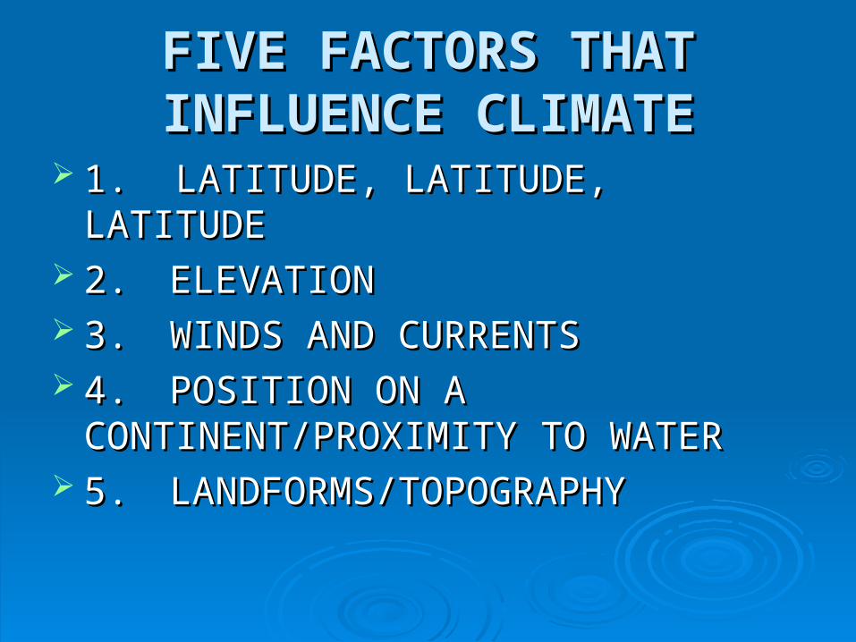
FIVE FACTORS THAT FIVE FACTORS THAT INFLUENCE CLIMATEINFLUENCE CLIMATE
1. LATITUDE, LATITUDE, LATITUDE1. LATITUDE, LATITUDE, LATITUDE 2.2. ELEVATIONELEVATION 3. 3. WINDS AND CURRENTSWINDS AND CURRENTS 4.4. POSITION ON A POSITION ON A
CONTINENT/PROXIMITY TO WATERCONTINENT/PROXIMITY TO WATER 5.5. LANDFORMS/TOPOGRAPHYLANDFORMS/TOPOGRAPHY

LATITUDE, LATITUDE, LATITUDE, LATITUDE, LATITUDELATITUDE
Latitude is the MOST IMPORTANT factor Latitude is the MOST IMPORTANT factor affecting or influencing climate in a regionaffecting or influencing climate in a region
Lower latitudes generally have warmer Lower latitudes generally have warmer climatesclimates
Higher latitudes generally have colder Higher latitudes generally have colder climatesclimates

EXCEPTIONS TO THE RULEEXCEPTIONS TO THE RULE
There are exceptions to the rule that There are exceptions to the rule that Higher Latitudes generally have colder Higher Latitudes generally have colder climatesclimates
Western Europe is an example --- Western Europe is an example --- because of the Gulf Stream and the third because of the Gulf Stream and the third factor influencing climate: WINDS AND factor influencing climate: WINDS AND CURRENTS CURRENTS

WESTERN EUROPEWESTERN EUROPE
The climates of Western Europe are The climates of Western Europe are milder than places elsewhere on Earth that milder than places elsewhere on Earth that have similar latitudes have similar latitudes
The reason: the warm waters of the Gulf The reason: the warm waters of the Gulf Stream and the winds that blow across Stream and the winds that blow across them towards the continent them towards the continent

As the Gulf Stream brings warm water As the Gulf Stream brings warm water from the Gulf of Mexico and the Caribbean from the Gulf of Mexico and the Caribbean north and east towards Western Europe, north and east towards Western Europe, winds blow off of the Atlantic on shore winds blow off of the Atlantic on shore bringing with them the warmer air from the bringing with them the warmer air from the currentcurrent
The result: a warmer climate in Western The result: a warmer climate in Western Europe than in other places with similar Europe than in other places with similar latitudes latitudes