THE GREEK EEZ: RINCIPLES of a G ANALYSIS greek eez... · 2019-01-24 · WΟRKING PAPER No 17 J U LY...
40
W ΟRKING P APER No 17 JULY 2013 THE GREEK EEZ: PRINCIPLES of a GEOPOLITICAL ANALYSIS Ioannis Th. Mazis Professor of Economic Geography - Geopolitics, National and Kapodistrian University of Athens and Dr. Georgios - Alexandros Sgouros Physicist - Oceanographer, National and Kapodistrian University of Athens
Transcript of THE GREEK EEZ: RINCIPLES of a G ANALYSIS greek eez... · 2019-01-24 · WΟRKING PAPER No 17 J U LY...

WΟRKING PAPERNo 17
J U L Y 2 0 1 3
THE GREEK EEZ:PRINCIPLES of a GEOPOLITICAL
ANALYSIS
Ioannis Th. MazisProfessor of Economic Geography - Geopolitics,
National and Kapodistrian University of Athens
and
Dr. Georgios - Alexandros SgourosPhysicist - Oceanographer,
National and Kapodistrian University of Athens


The IENE Working Papers
The series of Working Papers published by IENE refer to selected and topical subjectareas in the broad energy and environmental domain and are written by specialists
in their particular field.The main objective of the IENE Working Papers is the updating of its members but alsoof the energy community at large on key energy issues which are of general interest andtherefore warrant a much wider public discussion. At the same time the Working Papersare useful to both IENE and the authors as an initial sounding board for the ideas andconcepts which they present, prior to their publication in learned journals or as part ofbooks.The present Working Paper refers to the Greek Economic Exclusive Zone (EEZ) and thePrinciples of a Geopolitical Analysis. IENE wishes to thank its authors Professor JohnMazis of the University of Athens and Dr. George-Alexandros Sgouros for their mostvaluable contribution.
3

First Published: July 2013
Institute of Energy for S.E. Europe (IENE)3, Alexandrou Soutsou, 106 71 Athens, Greecetel: 0030 210 3628457, 3640278 fax: 0030 210 3646144web: www.iene.gr, e-mail: [email protected]
All rights reserved. No part of this book may be reprinted or reproduced or utilizedin any form or by any electronic, mechanical, or other means, now known or here-after invented, including photocopying and recording, or in any information storageor retrieval system, without permission in writing from the publishers.

Contents
Summary...........................................................................................................................p. 7
1. Introduction................................................................................................................p. 9
2. Current Situation: Measures and Estimations for the Greek EEZ ..........p. 14
3. Demarcation of an EEZ between Greece and Turkey.Requirements and limitations subject to the 1982International Law of the Sea ...................................................................................p. 19
4. Turkey defines in advance, and without official statements,the limits of the EEZ using its own baselines and its ownspecification of points on its physical coastline, using the samecalculation principle: Obstructing the OGS Explora.......................................p. 26
5. History of actions and statements by interested state actors ...............p. 29
6. Geopolitical Conclusions.....................................................................................p. 35
Bibliography ................................................................................................................p. 37

7
Summary
This paper comprises four parts. The first part presentsand substantiates Greece’s legal position with regard
to the process of unilaterally establishing an EEZ andanalyses the basic concepts, the terms and conditionsof this process before resorting to the InternationalCourt of the Law of the Sea (International Court of Ham-burg). The second part presents the various scenariosbased on the Voronoi chartographic method, with re-gard to the delineation of the Greek-Turkish-CypriotEEZ, with or without the island complex of Megisti-Strongyli and Ro. The third part presents a history of ac-tions and statements between Turkey and the Republicof Cyprus, as it took place following determination ofCyprus’Economic Exploitation rights. The fourth part in-cludes our geopolitical conclusions, through an analysisof Turkey’s political behavior, depending on its geo-strategic aims.

Keywords:Greek Exclusive Economic Zone/EEZ, Davutoğlu, Cyprus-Turkey EEZ, Geopol-itics, Strategic Depth, Kastelorizo, Megisti-Strogyli-Ro, Aegean Sea, hydrocarbons.

The Greek EEZ: Principles of a Geopolitical Analysis1
1. Introduction
The latest developments in the geopolitical complex of the Eastern Mediterraneanand more particularly in the dipole of Greece and Turkey, correspond to the im-
plementation stage of Turkey's geo-strategic goals. This is witnessed, inter alia, bythe declarations of the Turkish Foreign Minister, A. Davutoğlu, during his visit toGreece, in March 2011. The sincerity of these declarations should be taken forgranted, and should have been expected by the Greek diplomacy. Needless to re-mind, that Davutoğlu's positions had appeared already in the 2001 first edition ofhis book, Stratejik Derinlik. Türkiye'nin Uluslararası Konumu, Küre Yayınları (İstanbul2004). The book has already been reprinted... 18 times, in Turkey only2. The authorpresents, inter alia, his known theory of “zero friction with Turkey's neighbours”.However, he rejects his theory with regard to Greece, and refers to the so-calledstrategic chock point of transport and defence-related flows in the Dardanelles, aswell as to the strategic importance of Thrace and of Phanari (tr. Fener)!
In other words, he posits that:
(a) At this geopolitical and geographical point of Turkish geo-strate-gic influence on the Balkan Peninsula and the Aegean Sea, Turkey isfaced with two, geo-strategically competitive, poles of power: Greeceand Russia. It also sees the “Patriarchate of Phanari” (sic) as a geopo-litical catalyst of Greece's geo-strategic goals in this chock point andconsiders that the Patriarchate, together with “the small Rum [Greek]community aims to acquire an ecumenical character (sic!)”. With re-gard to Russia and its claims on the Straits, Turkey's officials posit thatRussia “tries to exercise influence on the Orthodox Slavs in the regionof the Balkans and of Caucasus”.
9
1. First published in Greek: «Η Ελληνική ΑΟΖ και το Καστελόριζο. Αρχές μιας ΓεωπολιτικήςΑνάλυσης», Επίκαιρα (Epikera, special edition), 2011. Translated into English by Ioan-nis E. Saridakis.
2. The book has been published also in Greek: Το στρατηγικό βάθος και η διεθνής θέση τηςΤουρκίας [Strategic Depth and Turkey's International Position], Athens, 2010.
(b)Thrace is the extension portal for Turkey's neo-Ottoman influencein the Balkans. He considers that it is part of a “security zone createdin Eastern Thrace during the Cold War”, which must be“expanded fur-ther to the West, based on multilateral and bilateral agreements thatwill be concluded on the level of the Balkans”.3 Moreover, he positsthat this expansion is highly competitive vis-a-vis Russia, in absoluteCold War terms, as a necessary element for the creation of “securityaegises in the periphery or outside it, aiming to counterbalance theRussian factor in the region and mainly to prepare a master plan toguarantee the internal security and the territorial integrity of Albania,of Bosnia and of Macedonia (sic!)”.4
On the Dardanelles – Aegean Sea trade corridor, however, it is reasonable forthe Turkish Foreign Minister to include the Greek Dodecanese and to posit, clearlyand unreservedly, that “at this point, the geopolitical and military reality must bealigned with the economic and political reality. In the sameway, it is necessary toincrease the dependence of the Dodecanese on the continental plate of AsiaMinor... (NB: the author refers to Turkey and provides also a geopolitical dimension,which he aims to utilise so as to disallow Kastelorizo from claiming an EEZ or a con-tinental shelf, even though the geopolitical dimension is currently absent from the1982 Convention on the Law of the Sea”.5
Three questions arise from Davutoğlu’s text:
1.What constitutes the danger for internal security and integrity ofthese three nation-state entities?2. Which is Turkey's influence on the non-completion of the Russia-Burgas (Bulgaria) – Alexandroupolis (Greece, Thrace) pipeline?3. To what extent does Davutoğlu think that the designation ofFYROM as “Macedonia” reduces the friction between his country andGreece? It is of course reasonable, in the context of the said geo-strate-gic Turkish framework, for Ankara to invest in naval bases in Albania,since it insists on being involved as a “protective power” for the inter-ests of Bosnia, and because it has recognised FYROM with its consti-tutional name “Macedonia”.
10
3. A. Davutoğlu, op. cit., p. 202.4. A. Davutoğlu, op. cit., p. 202.5. op. cit. p. 235.

However, and in order to fully explicate the intentions and the meaning of Mr.Davutoğlu's text, when referring to “zero friction with Greece”, it is worth noting hisremark that “effort is being put so that Turkey familiarises itself with tensions in itsrelations with Greece and Syria: this corresponds to the training of a heavyweightwrestling athlete to face a mid-weight athlete (sic!).6 This results in the country notbeing able to utilise its full potential. Turkey is now obliged to upgrade itself, so asto treat its relations with these countries from a higher level, and only exercise poli-cies from above towards them (sic!)”.7
However, in the geo-complex of the SE Mediterranean, the Turkish ForeignMinister is right to include also Cyprus. It is where Davutoğlu's cynicism is clear inadopting the harshest possible classical principles of “Geopolitik”.Citing from the FM's text:
1. “The latest developments have shown that] the US, by creating adynamic relation between their Eastern European and Middle East-ern policies, aim to control Europe's Hinterland and to fill the gap inthe geopolitical field that emerged after the dissolution of SovietUnion. The Aegean Sea and Cyprus are two important elements, bothon the Eastern Europe – Middle East axis, in terms of land connection,and on the Adriatic Sea – Eastern Mediterranean – Gulf axis, in termsof sea connection.8
2. “(...) Within this strategic planning, the Cyprus issue will come tothe foreground in a more drastic manner. (...) Nowadays, a field of ahighly dynamic interaction is formed between Eastern Europe, theBalkan Peninsula, the Adriatic, the Aegean, Eastern Mediterranean,Middle East and the Gulf. (...) On this line, unifying the Balkans and theMiddle East, the development of new onsets will be unavoidable”.3. “[chapter section title] 'The strategic Gordian knot of Turkey: Cyprus”“Cyprus, having a central position within the global continent, andbeing located at an almost equal distance from Europe, Asia and Africa,is located together with Crete on a line traversing the maritime corri-dors. Cyprus holds a location between the Straits separating Europe andAsia, the Suez Canal, separating Asia and Africa, while it also acts as a sta-ble base and an aircraft carrier catching the pulse of the sea corridors ofAden and Ormuz, together with the basins of the Gulf and the CaspianSea, i.e. the most important routes connecting Eurasia with Africa”.9
11
6. NB: What a...“delicate” and “peaceful” approach!7. A. Davutoğlu, op. cit., p. 235.8. Stratejik Derinlik. Türkiye’nin Uluslararası Konumu, Küre Yayınları, İstanbul 2004, 18th edition,
1st edition 2001, p. 174.9. op. cit.

4. “A country ignoring Cyprus cannot be active in world and periph-eral politics. In world politics, it cannot be active, since this small is-land occupies a position that (can) influence(s) directly the strategicconnections between Asia – Africa, Europe – Africa and Europe – Asia.In peripheral politics, it cannot be active, because Cyprus, with its East-ern nose, stands as an arrow turned to the Middle East, while with itsEastern back, it is the cornerstone of the strategic balances existing inthe Eastern Mediterranean, in the Balkans and in Northern Africa”.10
5. “Turkey, affected because of its location by a multitude of balances,is obliged to evaluate its policy on Cyprus, withdrawing it from theequation of Turkish - Greek relations. Cyprus is increasingly becominga matter of Eurasia and Middle East – Balkans (Western Asia – EasternEurope). Turkey's policy on Cyprus must be placed in a new strategicframework and in a manner compatible with this new strategic frame-work. On the Cyprus issue, and from Turkey's point of view, emphasiscan be put on two main axes. One of these axes is human value, andis oriented towards safeguarding the security of the Muslim commu-nity, as a result of Turkey's historic responsibility. (...)”.11
6. “A possible incompetence of Turkey which will [eventually] becomeprominent as pertains to safeguarding and protecting the Turkish mi-nority of Cyprus could expand as a wave in Western Thrace and in Bul-garia, and indeed also in Azerbaijan and Bosnia. The second importantaxis of the Cyprus issue is the importance of this island from a geo-strategic point of view. (...) Even if there were no Muslim Turks onCyprus, Turkey would be obliged to have a Cyprus issue. No countrycan be indifferent vis-a-vis such an island, located at the heart of itsown vital space. (...)”.12
7. This geo-strategic importance has two dimensions. One of thesehas a major strategic importance and relates to the balances betweenTurkey and Greece, and TRNC and Greek Territories (sic!) in the EasternMediterranean. The second dimension of the geo-strategic impor-tance is major and relates to position of the island within the worldand peripheral strategies”.13
8.No peripheral or world power having strategic prospects in the Mid-dle East, the Eastern Mediterranean, the Aegean Sea, Suez, the RedSea and the Gulf can ignore Cyprus. Cyprus is located at an ideal dis-
12
10. op. cit., Stratejik Derinlik. Türkiye’nin Uluslararası Konumu, KüreYayınları, İstanbul 2004, p. 176.11. op. cit., Stratejik Derinlik. Türkiye’nin Uluslararası Konumu, KüreYayınları, İstanbul 2004, p. 178.12. op. cit., Stratejik Derinlik. Türkiye’nin Uluslararası Konumu, KüreYayınları, İstanbul 2004, p. 179.13. op. cit., Stratejik Derinlik. Türkiye’nin Uluslararası Konumu, KüreYayınları, İstanbul 2004, p. 179.

tance from all those regions and acts as a parameter that can influ-ence each and every one of them. Turkey should exploit the strategicadvantage it gained in the 1970s on this parameter, not as an elementof defensive Cyprus policy aimed to safeguard the status quo, but asa fundamental support of an aggressive sea strategy of a diplomaticnature”.14
During his visit to Greece, the Foreign Minister's statements went no furtherthan his academic publications. Therefore, there is no room for surprise in Athens.And the criticism by the mass media and Greek diplomatic commentators shouldnot relate to his ... bourgeois politeness and his ... good manners! Any criticismshould relate to the level of geopolitical and geo-strategic perception of the Sys-tem of SE Mediterranean. It would be better to have no criticism at all, than to havethis kind of criticism. One of the issues that must be taken seriously into considera-tion by Turkey, in response to the theories of Ahmet Hodja, is its proper positionwith regard to the demarcation of a Greek EEZ, which should not be delayed, giventhat the intents of Turkey have now been made clear, and are posited by officials,even in scientific contexts... In other words, in the context of the greater geopoliti-cal game and the geopolitical reforms developing in the Eastern Mediterranean andthe oil-bearing Muslim world, both on and beyond the Mediterranean coastline,three are the main focal points for demarcating a Greek EEZ:
(a) Greece's significant relations with Israel and the important politi-cal support that is openly offered by Jerusalem to Athens is a majorpolitical trust, which should not be consumed without a reason or belimited to the exchange of official visits between the two states.Greece's current state of economy urges in this direction, while wait-ing and navel-gazing are no aid at all. On the contrary, they diminishthe level of trust shown by Jerusalem to Athens.(b) The discovery of natural gas reserves in Israel's EEZ should be chan-nelled to the European market, as soon as possible, particularly amidstthe energy instability caused by the explosion of national social for-mations in Tunisia (natural gas), Libya (natural gas and high qualitycrude oil) and Egypt (new natural gas reserves in the Nile Delta regionand in the submarine areas north of the Delta, within the EgyptianEEZ). Consequently, the axis of flow of non Arab-Muslim and non-Russian hydrocarbons towards the EU is the one defined by the Israel–Cyprus–Greece (Kastelorizo–Crete–Ionian Sea) – EU route.(c) Recent geophysical explorations in Cyprus would lead, mathe-matically and within the next 5 to 10 years, to corresponding
13
14. op. cit., Stratejik Derinlik.Türkiye’nin Uluslararası Konumu, KüreYayınları, İstanbul 2004, p. 180.

processes also in the Greek space, both on land and on sea, either will-ingly by Athens and with the corresponding benefits for the stallingGreek economy, either unwillingly and without such benefits!15
The said 5 to 10 year period is defined as the time necessary for the com-mencement of the exploitation of the Leviathan reserve in the Israeli EEZ, given thatthe Noble Energy & Delek (Israel) consortium is currently preparing a storage facil-ity for LNG derived from this reserve, as well as a storage facility for carbon monox-ide produced from the completion of the drilling. However, achieving this targetrequires the demarcation of the Greek EEZ, properly timed and in consultation withthe Cypriot and the Israeli authorities. However, any timing on the part of Greeceshould take into consideration the developments in the region and make properuse of them, together with the said 5 to 10- year period, within which any legalarrangements before international judicial bodies (Hamburg) must be finalised.Moreover, Greece resorting to international adjudications for the final settlementof the boundaries between the Greek and the Turkish EEZs, even if this would meanpartly waiving Greece's EEZ, e.g. about 25% of its total area, would be preferable towaiving its rights over the entire area, together with the corresponding prospec-tive methane hydrate deposits of the Anaximander Mountains.16 In this paper, oureffort is to exemplify the evolution of the geopolitical game, in the context of de-lineating Greece's EEZ by applying the 1982 Convention on the Law of the Sea.
2. Current Situation: Measures and Estimationsfor the Greek EEZ
Before discussing the size and the geopolitical importance of the EEZ, it is neces-sary to give an account of the most important elements of its legal definition, so
as to avoid doubts and misinterpretations. We shall refer to the new Convention ofthe Law of the Sea, i.e. the 1982 Montego Bay Convention.17
14
15. On the condition, of course, that there will be a government body for the exploitation ofthese deposits in Greece.
16. As pertains to methane hydrates, see our publication in Epikera, 26 (15-21 April 2010).17. The 1982 UN Convention of the Law of the Sea (UNCLOS) includes precise deenitions of
the Territorial Sea, the Contiguous Zone, and the Exclusive Economic Zone (EEZ). UN-CLOS was signed in Montego Bay of Jamaica and its implementation started on 16November 1994, replacing four precedent international treaties. In a vote that tookplace on 30 April 1982 in New York on the ratiecation of the new convention, 130states voted for, 4 voted against and 17 abstained. Turkey was one of the states thatvoted against the convention. By the end of 2008, UNCLOS had been ratieed by 157states, including Cyprus (12 December 1988) and Greece (21 July 1005).

1. Article 55. “The exclusive economic zone is an area beyond and ad-jacent to the territorial sea, subject to the specific legal regime estab-lished in this Part, under which the rights and jurisdiction of thecoastal State and the rights and freedoms of other States are governedby the relevant provisions of this Convention [Montego Bay, 1982]”.2. Article 56.“In the exclusive economic zone, the coastal State has: (a)sovereign rights for the purpose of exploring and exploiting, con-serving and managing the natural resources, whether living or non-living, of the waters superjacent to the seabed and of the seabed andits subsoil, and with regard to other activities for the economic ex-ploitation and exploration of the zone, such as the production of en-ergy from the water, currents and winds; (b) jurisdiction as providedfor in the relevant provisions of this Convention with regard to: (i) theestablishment and use of artificial islands, installations and structures;(ii)marine scientific research; (iii) the protection and preservation ofthe marine environment; (c) other rights and duties provided for inthis Convention”.18
3. Article 57. “The exclusive economic zone shall not extend beyond200 nautical miles from the baselines from which the breadth of theterritorial sea is measured”.19
An example from the Greek case is the following: Breadth of the territorialsea + width of the EEZ = 200 nm. In the present, in the current state of affairs, i.e. ofthe Greek territorial sea extending to 6 nm, this equation reads as follows: 6 nm +194 nm = 200 nm = EEZ!
“This means that the notion of the EEZ currently includes both the traditionalsovereign rights which the coastal state exercised on the continental shelf, i.e. on thenatural resources of the seabed and the subsoil of its adjacent marine areas, andthe new sovereign rights related to research, exploitation and preservation of thenatural resources of the overlying waters, i.e. mainly of fish catches. Moreover, ad-ditional jurisdictions were given to the coastal state (i.e. exclusive authorisations)with regard to installing and using artificial islands and other constructions, to con-ducting scientific research and to protecting the marine environment from pollu-tion. There was no consequence for the traditional freedoms of internationalcommunication of the other states within the limits (navigation, overflights, and
15
18. B. Καρακωστάνογλου, Η Αποκλειστική Οικονομική Ζώνη στο Νέο Δίκαιο της Θάλασσας, Σάκ-κουλας, Θεσσαλονίκη [in Greek; V. Karakostanoglou, The Exclusive Economic Zone in theNew Law of the Sea, Sakoulas publications, Thessaloniki], 2001, pp. 54 , 559, (SectionV, Provisions of the 1982 Convention on the EEZ; source: Act no. 2321 (Greek Govern-ment Gazette A136/23.6.1995).
19. V. Karakostanoglou, op. cit., p. 54.

placement of cables and pipelines). This new institution, that was already applied ex-tensively in the practice of states, even before its contractual establishment, con-stitutes already part of the customary international law”.20
However, as pertains to the continental shelf, the formulations are quite clearand are indeed reinforced by the 1982 Montego Bay Convention. On the basis ofthis Convention,21 one of the most vexed issues of the Law of the Sea was resolved:an agreement was reached on the breadth of the territorial sea, which can no reacha limit of 12 nautical miles (nm). Indeed, this rule has also become customary, owingto its extensive use. Moreover, in view of delineating overlapping territorial seas,the median line principle was adopted, with very few exceptions (Article 15). Thisprinciple can cover fully the case of Greece and Turkey.
Moreover, it should be mentioned that the rights exercised by the coastalstate having the said continental shelf are exercised in the form of“sovereign rights”:in other words, no other state can lay claim to such rights, even if the coastal statein question fails to exercise such rights in practice. Also, it should be stressed that,based on a resolution of the International Court of Justice in Hague (North Sea Con-tinental Shelf case22), such rights exist in favour of the coastal state, ipso jure and abinitio, without this state having to take any legal action in this respect.23
Let us make, however, one more clarification with regard to the continentalshelf: the continental shelf and its regime, as is currently defined in the InternationalLaw, is ceded to the coastal state, for both practical and political reasons. How is thisnotion distinguished from its geological definition? Based on the 1982 MontegoBay Convention on the Law of the Sea, the continental shelf of a coastal state com-prises basically the seabed, within a distance of 200 nautical miles from the coast.This principle applies regardless of the geological formation of the seabed. How-ever, in case the continental margin (continental shelf, continental slope and conti-nental rise) extends beyond 200 miles from the baseline, the continental shelf isdeemed to extend either up to 350 nm, or up to 100 nm beyond the 2,500 metre iso-bath, or up to 60 nm from the base of the continental rise.24, 25
16
20. 21. V. Karakostanoglou, op. cit., p. 53-54.22. See ICJ Reports (1969), par. 19 in: V. Karakostanoglou, op. cit., p. 42.23. See Κ. Οικονομίδης, Βασικές Ρυθμίσεις του Νέου Δικαίου της Θάλασσας, Δίκαιο και Πολιτική,
Παρατηρητής, [in Greek: K. Economides, Main Privisions of the New Law of the Sea,Dikeo ke Politiki (Law and Politics), Paratiritis publications], vol. 9., 1985, p. 176-177. In:V. Karakostanoglou, op. cit., p. 42.
24. Unofficially, it has been argued that in the case of Greece, e.g. south of Crete, where thephysiography an the steep bathymetry exceed 2,500 m., the extension of the conti-nental shelf reaches only 100 nm. This is of course a misunderstanding. Based on thedeenition of this paragraph, the 100 nm extension is possible only beyond the 200 nmline. The authors hope they have aided in the resolution of this ambiguity.
25. See Εμμανουήλ Ρούκουνας, Διεθνές Δίκαιο, τεύχος ΙΙ (Το κράτος και το έδαφος - Το Δίκαιοτης Θάλασσας) [in Greek: E. Roukounas, International Law, vol. 2: The State and theTerritory. The Law of the Sea], Athens, Sakoulas publications, 2005.

Until today, all mentions of the Exclusive Economic Zone have as their point ofreference the database of the Flanders Marine Institute, which is to date used widelyin all publications in the press that relate to the issue of the EEZ. However, as men-tioned by the Flanders Marine Institute, the construction of the EEZ is theoretical. Inpractice, this implies that a scientifically accepted method has indeed been adopted,albeit without accuracy or safeguards for the detailed demarcation of the EEZ.
It is however obvious that Greece has to date relied on the map published bythe said institute (seaaroundus.org ). It is worth mentioning, however, that this postincludes the following:
1. “Disclaimer: Maritime limits and boundaries depicted on SeaAround Us Project maps are not to be considered as an authority onthe delimitation of international maritime boundaries. These mapsare drawn on the basis of the best information available to us. Whereno maritime boundary has been agreed, theoretical equidistant lineshave been constructed. Where a boundary is in dispute, we attemptto show the claims of the respective parties where these are known tous and show areas of overlapping claims. In areas where a maritimeboundary has yet to be agreed, it should be emphasized that ourmaps are not to be taken as the endorsement of one claim over an-other ”.
2. With regard to the accuracy of demarcation: “The EEZ boundarieswe use in our database were adapted from the public domain “Mar-itime Boundaries Geodatabase”available from the Flanders Marine In-stitute (VLIZ, Belgium), overlaid onto the ½ degree x ½ degree spatialcells GIS system of our database. Given the ½ x ½ degree nature ofour GIS system, area measurements of EEZs based on our data maydiffer slightly from those of other systems, and should be consideredapproximations. Note also that we deal with major disputed areas andunsettled boundary disputes by presenting the areas as non-countryspecific ‘disputed areas’ with reference to those countries involved inthe claim. Also note (1) that some countries (e.g., around the Mediter-ranean) have not declared EEZ, in which case we defined EEZ bound-aries for these countries based on data and the general methods usedby the Flanders Marine Institute, as if these countries were to applythe UNCLOS rules to their definitions, (2) that some countries (notablyEuropean Union member states) do not use EEZ for fisheries man-agement. Surface areas are expressed in km² and were obtained byoverlaying a global 2-minute cell ESRI GRID of surface area values witha matching ESRI GRID of EEZs (based on General Dynamics AdvancedInformation Systems database, see above). For each EEZ the inter-
17

secting surface area based on the 2-minute raster was extracted andsummed. The area of each ‘EEZ shelf’ was prepared in a similar waybut was truncated at 200 m depth, i.e., at the shelf edge, based on theUnited States National Geophysical Data Center’s ETOPOS GLOBAL 2’ELEVATION data ”.
The general conclusion drawn from these paragraphs is as follows:
The maps have been drawn using the best information available, withoutreference to the degree of accuracy of such information. For this reason, any refer-ence to this database is without legal documentation. In spite of this fact, data gath-ered from official Internet sources leads to the conclusion that the delimitation ofthe EEZ, even in the context performed by the Flanders Marine Institute, have beenderived from a database created by a pertinent European research programme fo-cused on the erosion of coasts.26 In the said database, Turkey's coastline is generic,to such an extent so as not to follow the geomorphology of the Turkish coastlinewith accuracy. However, there is a specific delimitation of baselines by Turkey (seeFigs. 2 and 3). The Flanders Marine Institute does not clarify if this form of the Turk-ish coastline was used for calculating the median line or the baselines.
As pertains to the accuracy of the demarcation of the EEZ, there is no clearconclusion to be drawn from the information provided on the said website(searoundus.org). However, as regards the Greek insular coastline in particular, aswell as the coastline of Turkey, which is characterised by a clearly notched geomor-phology, it is obvious that more accuracy cision is indispensable, so as to specifyboth the points and the drawing lines.
Consequently, there is no guarantee for Greece that the map proposed bythe above-mentioned institute is a sound legal basis that could be used by the Greekauthorities to safeguard national sovereignty (sea borders between Greece andTurkey, Greece and Albania, Greece and Libya, Greece and Cyprus, Greece andEgypt). For reasons of scientific method, the authors have considered that the sameprocedure should be applied, with the required accuracy and by necessarily takinginto consideration the legal clauses that govern the geometrical drawing. Thismethod proves that there should be no room for complacency on the Greek side,while also providing the Greek authorities with examples of geometrical drawings,which Greece would probably have to confront, if and when it resorts, without priorpreparation, to the international judicial fora or if it relies on its common argumentsabout the continental shelf or the EEZ (an issue that is, surprisingly, stressful for
18
26. Erosion GIS Database, http://www.eea.europa.eu/data-and-maps/data/maritime-boundaries.

Greek politics). For example, in the maps below (Figs. 4, 5), the deviations are clearbetween the sea borders that are drawn using the Voronoi diagram method and byrespecting the said accuracy of geometrical drawing, on the one hand, and the non-accurate borders proposed by the Flanders Marine Institute, subject to the saidreservations, on the other.
3. Demarcation of an EEZ between Greece andTurkey.Requirements and limitations subject to the 1982
International Law of the Sea
In view of demarcating the EEZ between Greece and Turkey, we have taken intoconsideration all of the international rules emanating from the said Articles 55 and
56 of the Law of the Sea. Besides, the process is based also on corresponding casesof application of the Law of the Sea, in delineating the EEZ of other countries aswell, particularly in cases where the “median line”27 method was implemented. Inparticular, and given that this is a geographical process,28 the following rules andlimitations were taken into consideration:
(a) For Greece: Points of the physical coastline were taken into con-sideration, on the bases of which straight lines were drawn accordingto the definitions derived from the Law of the Sea. Therefore, the basiclevel of information is the list of points that make up the line segmentsof the baselines.
(b) For purely technical reasons, we performed also an analysis of theTurkish baselines. Where possible, we increased the number of pointsof Turkey's physical coastline, particularly at areas where the distancebetween the two coastlines is very small. In other words, we increasedthe number of points, so as to increase the accuracy of the baselinecalculation. Using special mapping software, we georeferenced themap depicted in Fig. 3. The endpoints of the baseline segments arethe second basic level of information.
19
27. Cosquer, G., Hangouët, J.- F. (2003). Delimitation of Land and Sea Boundaries: Geodetic andGeometric Bases. FIG Working Week 2003, Paris, France, April 13-17, 2003. This articlerefers to the separation of the EEZs between Qatar and S. Arabia in 1999, usingVoronoi transformations. See also: Christensen, A.H.J., A Fully Automated Sea Bound-ary Delineator, Proceedings of FIG XXII International Congress, Washington, D.C. USA, 19-26 April 2002”, Session JS12 Marine Cadastre [www.eg.net/egtree/pub/eg_2002/Js12/JS12_christensen.pdf].
28. This is distinguished from Topography or any other measurement method, since Geog-raphy examines the solution of the problem in its entirety, and in the most compre-hensive way, both topographically and from a legal and historical viewpoint.

(c) The information below is addressed to readers who are unfamiliarwith the notion of baselines. According to the Law of the Sea,29 thereare two types of baselines:
i. Normal baselines, calculated from the low-waterline (Article 5);
ii. Straight baselines, in cases where the coastline presents an irregu-lar geomorphology (Article 7), for example if it is notched. The methodof calculation used with regard to baselines in cases of rivers, bays,ports and generally of any other geomorphological irregularities de-pending, for example, by the tidal, wave or wind regime, is defined inArticles 8 to 15 of the Law of the Sea. Based on the above, every statecan define its baselines in order to delineate its territorial sea and, byextension, the EEZ.
20
29. Articles 5 and 7 of the UNCLOS refer to the preconditions for drawing the baselines, as fol-lows:“NORMAL BASELINE. Except where otherwise provided in this Convention, the nor-mal baseline for measuring the breadth of the territorial sea is the low-water linealong the coast as marked on large-scale charts officially recognized by the coastalState. STRAIGHT BASELINE. In localities where the coastline is deeply indented and cutinto, or if there is a fringe of islands along the coast in its immediate vicinity, themethod of straight baselines joining appropriate points may be employed in draw-ing the baseline from which the breadth of the territorial sea is measured. Where be-cause of the presence of a delta and other natural conditions the coastline is highlyunstable, the appropriate points may be selected along the furthest seaward extentof the low-water line and, notwithstanding subsequent regression of the low-waterline, the straight baselines shall remain effective until changed by the coastal State inaccordance with this Convention. The drawing of straight baselines must not departto any appreciable extent from the general direction of the coast, and the sea areaslying within the lines must be sufficiently closely linked to the land domain to be sub-ject to the regime of internal waters. Straight baselines shall not be drawn to and fromlow-tide elevations, unless lighthouses or similar installations which are permanentlyabove sea level have been built on them or except in instances where the drawing ofbaselines to and from such elevations has received general international recognition.Where the method of straight baselines is applicable under paragraph 1, account maybe taken, in determining particular baselines, of economic interests peculiar to the re-gion concerned, the reality and the importance of which are clearly evidenced bylong usage. The system of straight baselines may not be applied by a State in such amanner as to cut off the territorial sea of another State from the high seas or an ex-clusive economic zone.

Fig. 2. The Turkish Baselines (marked in red). Source: Office of the Geographer, US Department ofState.
Fig. 1. Depiction of the baselinedrawing method, according tothe UNCLOS. Source: Harold D.Palmer, Η., Pruett, L., (1999) GISApplications In Maritime Bound-ary Delimitation [http://proceed-ings.esri.com/library/userconf/proc99/pro-ceed/papers/pap938/p938.htm].

Fig. 3. The Turkish Baselines(detail; marked in red).Source: Office of the Geog-rapher, US Department ofState.
Fig. 4. The white dotted linerepresents the median lineof the EEZ, as calculated bythe Flanders Marine Insti-tute. The mistakes are obvi-ous, since this median linecoincides with land, withinthe Turkish territory!The second drawing wasperformed by the authors,based on points of thephysical coastline andusing Voronoi transforma-tions.

Fig. 5. The limits of the Greek EEZusing the Voronoi method, in theEastern Aegean, from the Dard-anelles to Kastelorizo, based onthe already drawn baselines ofthe Turkish coastline (see Fig. 2),as compared to the (admittedlyinaccurate) proposition of theFlanders Marine Institute(searoundus. org). The differ-ences are all but insignificant.
Fig. 6. Using the baselines of theTurkish coastline, it can be seenthat Turkey's EEZ contacts theEEZ of Egypt, at a length of 10nautical miles approximately.

Fig. 7. Distribution of methanehydrates by EEZ (Georeferenceand overlay of a map included inLykoussis et al., 2009)30.
Fig. 8. Distribution of methanehydrates by EEZ withoutKastelorizo (Georeference andoverlay of a map included in Lyk-oussis et al., 2009). There areclear differences, compared toFig. 7.
30. Lykousis et al. (2009) MudVolcanoes and Gas Hydrates in theAnaximander mountains (EasternMediterranean Sea), Marine andPetroleum Geology, 26.6, 854-872.
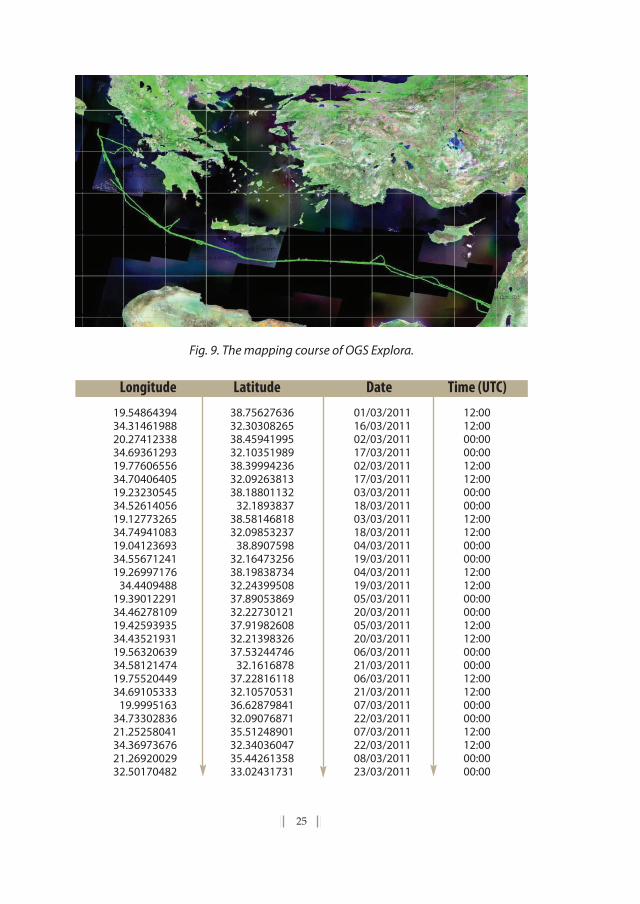
25
Fig. 9. The mapping course of OGS Explora.
Longitude Latitude Date Time (UTC)
19.5486439434.3146198820.2741233834.6936129319.7760655634.7040640519.2323054534.5261405619.1277326534.7494108319.0412369334.5567124119.26997176
34.440948819.3901229134.4627810919.4259393534.4352193119.5632063934.5812147419.7552044934.69105333
19.999516334.7330283621.2525804134.3697367621.2692002932.50170482
38.7562763632.3030826538.4594199532.1035198938.3999423632.0926381338.18801132
32.189383738.5814681832.09853237
38.890759832.1647325638.1983873432.2439950837.8905386932.2273012137.9198260832.2139832637.53244746
32.161687837.2281611832.1057053136.6287984132.0907687135.5124890132.3403604735.4426135833.02431731
01/03/201116/03/201102/03/201117/03/201102/03/201117/03/201103/03/201118/03/201103/03/201118/03/201104/03/201119/03/201104/03/201119/03/201105/03/201120/03/201105/03/201120/03/201106/03/201121/03/201106/03/201121/03/201107/03/201122/03/201107/03/201122/03/201108/03/201123/03/2011
12:0012:0000:0000:0012:0012:0000:0000:0012:0012:0000:0000:0012:0012:0000:0000:0012:0012:0000:0000:0012:0012:0000:0000:0012:0012:0000:0000:00

26
Longitude Latitude Date Time (UTC)
4. Turkey defines in advance, and without officialstatements, the limits of the EEZ using its own baselinesand its own specification of points on its physical coastline,
using the same calculation principle:Obstructing the OGS Explora
The incident that took place with the obstruction of the sailing of the OGS Exploraresearch vessel is an indication that Turkey's competent authorities have already
adopted the same method, in view of demarcating their own EEZ. The ship was per-forming mapping works for the deployment of a submarine cable from Haifa (Is-rael) to Italy. The incident was reported extensively also in the Greek Press.However, what is not obvious to date, is that this obstruction took place exactlyalong the EEZ demarcation limits, as detailed in this paper (see Fig. 9).
Let us examine the incident in geographical detail: the said map depicts thatthe course of the Italian research vessel (Explora) extends tangentially with respect tothe demarcation proposed by the authors, i.e. through the narrowest point of con-tact between the EEZs of Turkey and Cyprus. The course of the steep and unreason-ably diverging curve that is marked between points [1. 24/03/2011 00:00 UTC; 2.
21.8156119630.9070053122.13413998
30.488011822.1095090130.1856988522.9441927429.6535484824.4566588829.1202403326.0306953328.3360444827.3533630926.5483778127.0524344124.63182485
28.190339222.8636194330.3094225921.1174721432.7950494819.5884448834.2453609719.4599816934.66414467
35.2530417733.6232053
35.5514975933.8626786334.9913527934.07618242
34.758915333.8872691234.2691555233.8906535233.91794011
33.940296334.0142462833.9749112134.0201448334.2055786233.9462199934.7958126833.7925287135.6542084732.9782896137.0908520532.3377248837.2114816332.12105508
08/03/201123/03/201109/03/201124/03/201109/03/201124/03/201110/03/201125/03/201110/03/201125/03/201111/03/201126/03/201111/03/201126/03/201112/03/201127/03/201112/03/201127/03/201113/03/201128/03/201114/03/201128/03/201114/03/201128/03/201116/03/2011
12:0012:0000:0000:0012:0012:0000:0000:0012:0012:0000:0000:0012:0012:0000:0000:0012:0012:0000:0000:0000:0012:0012:0013:0000:00

24/03/2011 12:00 UTC; and 3. 25/03/2011 00:00 UTC] is, remarkably, located withinthe EEZ that has been demarcated by the authors using the Voronoi method, whichTurkey considers to be its own EEZ. It is for this reason that Turkey annoyed the Italianvessel while it was still within the Cypriot EEZ and before it entered into what Turkeyconsiders to be its own EEZ. Obviously, it is for this reason that the Italian vessel wasforced to request a second transit passage permission from the Turkish authorities.
This fact proves that Turkey tries to preoccupy the international communityto accept the limits of the EEZ which this country will claim to be its own, if Greeceinsists on its initial official statements and does not concede to the irrational Turk-ish claim that the islands of Kastelorizo, Stroggyli and Ro have no EEZ. Of course,this should be taken into serious consideration by Greece, so as to make the ap-propriate moves and to support its own arguments in a manner analogous to Turkeyand thus raise the level of negotiation, if it aims to achieve a final result, better thanthe one depicted on the above map. In short, the Archipelagic-type baselines in theAegean insular complex should not be rejected in principle as irrational. They aresimply a response to Turkey's legal irrational and arbitrary claim that “the islands ofthe Aegean have no continental shelf” and that “Kastelorizo is part of the Mediter-ranean”. Let us think clearly: what will we waive before an international court of jus-tice, so as to make Turkey waive such irrational legal claims?
Fig. 10. It is noted that thecourse of OGS Explora
extends tangentially to thedrawing presented in this
paper, i.e. through the nar-rowest point of contact of
the Cypriot and the TurkishEEZ. The course of the steep
curve between points[1. 24/03/2011 00:00 UTC;2. 24/03/2011 12:00 UTC;and 3. 25/03/2011 00:00
UTC] is, remarkably, locatedwithin the EEZ that has been
demarcated by the authorsusing the Voronoi method,
which Turkey considers to beits own EEZ.

28
Fig. 11. Detail of Fig. 9. The course of OGS Explora and the location of the said annoyanceand deviation from the predefined course (in rectangular frame). Below, the same loca-tion with respect to the Turkish perception of the limits of the Turkey-Egypt, Greece-Turkey, Greece-Cyprus and Cyprus-Turkey EEZs.

29
5. History of actions and statementsby interested state actors
A history of actions and statements between Turkey and Cyprus, is presentedbelow by Prof. Achilles Skordas31 as it took place following the determination
of Cyprus’s Economic Exploitation Zone and subsequent concession of exploitationrights, coupled with some additional comments by the author.
1. On February 17, 2003, Cyprus and Egypt signed the Agreement on theDelimitation of the Exclusive Economic Zone (EEZ). According to Article 1,paragraph 1, “the delimitation of the EEZ between the two Parties is ef-fected by the median line of which every point is equidistant from thenearest point on the baseline of the two Parties“.
2. A similar Agreement was signed on January 17, 2007 between Cyprusand Lebanon. In 2004, Cyprus enacted legislation for the proclamationof the EEZ extending not beyond 200 miles from the baselines from whichthe breadth of the territorial sea is measured, and contiguous zone, theouter limit of which should not extend beyond the 24 nautical miles fromthe same baselines.
3. On February 15th 2007, Cyprus opened a bidding process to license off-shore gas and oil exploration. In January 2009, a US-Israeli company an-nounced an 88 bcm natural gas find off the coast of Haifa, according toa Reuters news article).32 This company holds exploration rights for anadjacent block belonging to Cyprus’ Economic Exploitation Zone. Adja-cency (distance between 2 countries is merely 250 km)33 and geologicalindications suggest that there may be a link between these neighboringareas with respect to hydrocarbon deposits in this region. All said explo-ration fields are situated in the South, Southeast and Southwest of the Is-land, excluding thus any issue of EEZ settlement with Turkey, as seen inFigure [12]. “Despite this fact, Turkey has sharply protested the move byCyprus with Greece and the United States […]
31. Skordas, Achilles, 2007.“Oil Exploitation in the Eastern Mediterranean: Cyprus, Turkey andInternational Law, Woodrow Wilson International Centre for Scholars”, http:// www.wilsoncenter.org/index.cfm?fuseaction=events.event_summary&event_id=225758
32. Kambas, Michele, “Israeli Gas Find Raises Hopes in Cyprus”, (Reuters) AFX News Limited,Thursday, Jan. 22, 2009.
33. It seems quite reasonable to have had an already existing settlement of EEZ between Is-rael and Republic of Cyprus.

Fig. 12 Exclusive Economic Zones of Eastern Mediterranean countries (Based on the Flan-ders Marine Institute, Belgium Database and the Eurosion GIS Database)
4. In its statement of January 30, 2007, Turkey argued as follows34[...] theTRNC (Turkish Republic of Northern Cyprus) also has rights and author-ity over the maritime areas around the Island of Cyprus. Moreover, GreekCypriots do not represent the Island as a whole. Consequently, neither thelegislation adopted nor the bilateral agreements concluded by the GreekCypriot Authorities have any effect. In addition, it must also be kept inmind that Turkey has legitimate and legal rights and interests in the East-ern Mediterranean. Parts of the maritime areas that are subject of bilat-eral agreements intended to be concluded by the Greek CypriotAuthorities also concern Turkey’s stated rights and interests. Turkey is de-termined to protect its rights and interests in the Eastern Mediterraneanand will not allow any attempt to undermine them. In this context, we
30
34. Skordas, Achilles, 2007.“Oil Exploitation in the Eastern Mediterranean: Cyprus, Turkey andInternational Law, Woodrow Wilson International Centre for Scholars”, http://www.wilsoncenter.org/index.cfm?fuseaction=events.event_summary&event_id=225758

31
would like to remind those countries and companies that might considerconducting research for oil and gas exploration, based on invalid licensesGreek Cypriot Authorities may contemplate to issue for maritime areasaround the Island of Cyprus, to take into account the sensitivity of the sit-uation as well as the will of the Turkish Cypriots, the other constituentpeople of the Island.
5. In a further statement of February 15, 2007, Turkey refined its position:“Accordingly, we expect the Greek Cypriot Authorities to end their calls forinternational tender which are not based on common understandingamong the Eastern Mediterranean states, and thereby creating fait-ac-complis, violating the joint rights of the two peoples on the Island on is-sues like oil and natural gas exploration.
It is obvious, A. Skordas continues, the legal arguments of Turkeyare not convincing, and there does not seem to be any real legal disputebetween Turkey and Cyprus with respect to the latter’s EEZ delimitationagreements, apart from potentially overlapping claims on some mar-itime areas between Turkey and Cyprus. Instead, Turkey attempts to ex-ercise pressure on foreign companies and neighbouring states toindirectly undermine the effective exploration and exploitation of the re-sources of the EEZ.
6. Through identical letters addressed to the United Nations (UN) Secre-tary General and to the President of the Security Council dated January31, 2007 (A/61/726-S/2007/52/2 February 2007), Cyprus respon- ded byinvoking its sovereign rights: “Turkey has no right whatsoever to chal-lenge the delimitation of the EEZ or the continental shelf between the Re-public of Cyprus and its neighbouring States, in accordance with relevantprovisions of international law and in areas that are neither opposite noradjacent to Turkish coasts […]. The Government of Cyprus has no doubtsabout the sovereignty of the Republic of Cyprus over the maritime areassurrounding the island and the natural resources therein and rejects anyclaim by the Government of the Republic of Turkey to the contrary”.
The United States took a cautious approach, and avoided takingsides. On February 5, 2007, the spokesman of the State Department gavethe following answer:
«U.S. policy has not changed. Any dispute here is between the Re-public of Cyprus […] and Turkey. The United States is not a party to theseagreements. The State Department has no recommendations as towhether American companies should participate in the bidding process.The controversy, however, points to the need for all parties to focus on re-

starting the UN’s good offices mission to forge a comprehensive Cyprussettlement that reunifies the island into a bi-zonal, bicommunal federa-tion. The next step should be to implement the agreement brokered bythe Under Secretary-General Gambari, July 8, 2006. A final settlement willenable all Cypriots to benefit from the island’s resources».
Delimitation of EZZs
Stability and viability of the EEZ delimitation agreements lies on the ex-isting agreements between Cyprus, Egypt and Lebanon. There is no doubtthat the two agreements have been concluded under international law;they become binding upon the parties by the completion of the ratifica-tion process. […] None of them infringes upon Turkey’s sovereign rights,according to the presented technical analysis.
An important issue that may amend existing agreements is the -future- way to solve the Cyprus issue.35
If a future state of affairs in Cyprus takes shape in any form of statesuccession, it might be asked, whether the successor entity could claim a
32
35. To facilitate the reader, Article 83 on continental shelf is quoted:
1.The delimitation of the continental shelf between States with opposite or adjacentcoasts shall be effected by agreement on the basis of international law, as re-ferred to in Article 38 of the Statute of the International Court of Justice, inorder to achieve an equitable solution.
2. If no agreement can be reached within a reasonable period of time, the States con-cerned shall resort tot the procedures provided for in Part XV.
3. Pending agreement as provided for in paragraph 1, the States concerned, in a spiritof understanding and cooperation, shall make every effort to enter into pro-visional arrangements of a practical nature and, during this transitional pe-riod, not to jeopardize or hamper the reaching off the enal agreement. Sucharrangements shall be without prejudice to the enal delimitation.
4.Where there is an agreement in force between the States concerned, questions re-lating to the delimitation of the continental shelf shall be determined in ac-cordance with the provisions of that agreement.
Article 74 is identical, differentiated however by the replacement of the term“Continental shelf”with the term EEZ. When States are adjacent or facing eachother, with a distance less than 400 miles, then we have overlapping off sealimits. A useful reference covering major part off delimitation agreementsuntil 1992 can be found in International Maritime Boundaries (Charney andAlexander, 1993), in two volumes, updated in 1996 for the third volume, edi-tion 1998.

33
36. http://www.un.org/Depts/los/LEGISLATIONANDTREATIES/regionslist.htm http://www.un.org/Depts/los/LEGISLATIONANDTREATIES/PDFFIILES/DEPOSIT/cyp_mzn47_2004.pdf
37. Skordas, Achilles, 2007. The exact phrasing of the agreement in English is given in orderto avoid subjective translation into Greek by the author.
fundamental revision of the treaties. […] The delimitation agreementsconcluded by Cyprus followed the median line, which corresponds to theprinciple of equidistance, as recognized by the law of the sea. This is anadditional reason that practically precludes any future controversies onthe agreed line. [Εmphasis added]
Therefore, any further delay by Greece to delimit its EEZ with Cyprus isdeemed by Turkey as a token of laxity on behalf of Greece, whose government hasalready “tacitly” agreed on some sort of new state formation that will not be cov-ered by a Greece-Cyprus delimitation based on current data.
The Cyprus-Egypt agreement provides for review of the existinglies in two cases36: a) if more accurate data are available, thus giving thelegal right to any part to ask for redetermination of the median line andb) the geographical coordinates […] could be reviewed / extended as nec-essary in light of future delimitation of EEZ with other concerned neigh-boring state37[…].
This means that should existing lines infringe upon third countries’ conti-nental shelf, the counterparts are obliged to proceed with relevant amendments.
We must also add that currently, there are natural gas deposits in the Levan-tine sea basin and particularly in Israel‘s EEZ, that US-Israeli company Noble Energyhas been contracted to drill. These are the following:
(i)Tamar: 90 km off Haifa and at a depth of ~1680. Estimated reserves: 142 bcm.
(ii) Dalit: 13 km east of Tamar deposit. Estimated reserves: 14 bcm.
(iii) Leviathan: 130 km west of Haifa and at a depth of 1635 m. Estimated re-serves: 535 bcm
Moreover, it has to be mentioned that hydrocarbon indications, such as pock-marks, gas chimneys etc, highlight the importance of the Levantine basin regionwith respect to other deposits as well.
So, it is obvious that Israeli oil interests are being covered by the EEZ delim-itation between Israel and Cyprus as effected already by the late Tassos Pa-padopoulos’ government. The alignment of Israeli and Cypriot interests in the fieldof sub-sea hydrocarbons may act as a solid foundation for additional points of con-currence of political-economical interests, and partnerships on security. This is madeeven clearer in view of two facts:
(i) the, until recently, significant deterioration of the Turkish-Israeli relation-ships and
(ii) the close ties developed between Turkey and Syria-Lebanon, via the oc-cupied Cyprus territories, which act as transfer belts of Turkey‘s neo-osmanic-typepower on Arabic-Muslim actors, hostile to Israel, located in the inflammable Levan-tine basin region.
The latter becomes increasingly apparent by the coastal connection alreadyestablished between the occupied Cyprus areas and Tripoli of Lebanon, calling atLattakia of Syria, and which was inaugurated on August 25th 200938.
In any case, the overall state of affairs provides the necessary and sufficientcondition that may drive Greece into delimiting its own EEZ with Cyprus, thus en-suring westwards the existing favourable –and legally sound– balance in the Lev-antine Basin. However, that would be an act that would require the utmost diligenceand optimum timing39.
34
38. On Thursdays, a passenger carrier will bring 200 people with their vehicles from Tripoli,Lebanon, calling at Lattakia, Syria, to the port of [occupied] Famagusta. The returntrip will be conducted on Mondays with a duration of 6 hours. [see “Ancara imple-ments connection agreements with Lebanon, Syria, Iran and Pakistan”, Amintiki Ep-ithehorisi (Defence Review), n. 81, September 2009, pg. 10-11.
39. Chapter 5 of this Working Paper was erst published in Mazis, I. Th. & Sgouros, ”G.-A., Geopol-itics of Energy in The Kastelorizo - Cyprus –Middle East Complex: Based on The Exist-ing Geophysical and Geological Indications of Hydrocarbon Deposits”, RegionalScience Inquiry Journal, Vol. II (2), 2010

35
6. Geopolitical Conclusions
1. Based on the above, it is concluded that, on the one hand, the EEZ which mustbe clearly demarcated on the map in order to apply, is an indispensable part
of both the conventional and the customary Law of the Sea, which is applicable in-ternationally and, on the other, that it is an unalienable and unique right of thecoastal state concerned, to proceed with such a demarcation.
2. Besides, it should be made clear that the European and, mainly, the Anglo-Saxon geostrategic direction has changed over recent years. These two inter-
national poles of power (the EU and the US-UK [special relationship]) purport to beindependent from the Russian, Iranian and Arab-Islamic energy reserves. Also, inthe light of this explanation, the Anglo-Saxons of the said special relationship donot view positively a future dependence of the EU on Russia's natural gas, the retailerand distributor of which will be Germany in the EU. This is their chance to avoid thisscenario: the hydrocarbon deposits of Israel and Cyprus, together with those ofGreece (south of Crete, and in the Ionian Sea and up to the Adriatic), offer an idealsolution. Consequently, anyone raising obstacles to this geostrategic development(which in our case, arguably, is only Turkey) would have to face the harsh responseof the so-called “West”, i.e. of the EU and of the London-Washington Special Rela-tionship. Naturally, the Israeli factor, which is able to influence the Special Relation-ship, will clearly contribute to the same direction!
It must be further stressed that Greece should proceed with a tripartite arrange-ment of its EEZs with Egypt and the Republic of Cyprus, without any further delay,so as to safeguard the contact between the Greek and the Cypriot EEZ. If Greecefails to do so, Turkey will intervene to render this contact impossible, using themethod of the non-calculation of the insular complex of Megisti, Stroggyli and Ro.Moreover, in this way it will be in a position to lay claims on the methane hydratesof the area south and south-east of this insular triangle (see: Ι. Θ. Μάζης - Γ.Α. Σγού-ρος, «Κοιτάσματα στην Ανατολική Μεσόγειο», Επίκαιρα, 26, 15-21/4/2010), like inthe western side of the EEZ of Cyprus and the eastern side of the EEZ of Crete, inthe region of the Herodotus basin, where lies a Greek portion of natural gas depositsof about 1 trillion cubic meters, based on data published already (in the US, in Franceand in Norway). From a legal standpoint, however, an interfering Turkish EEZ wouldnot obstruct the passage of LNG tankers or the deployment of cables and pipelineson the seabed of the EEZ, even if through “political manipulation” this area ends up

as being considered Turkish subsoil. However, Turkey's behaviour is no guaranteethat it will ultimately respect the international rule of law. In this sense, it is imper-ative to eliminate such an eventuality, through a direct tripartite settlement.
Consequently, there is no excuse for phobic syndromes in Athens, with regard todecisive and targeted actions in the SE Mediterranean.

Bibliography
COSQUER, G., HANGOUËT, J.- F. (2003). Delimitation of Land and Sea Boundaries:Geodetic and Geometric Bases. FIG Working Week 2003, Paris, France, April13-17, 2003. This article refers to the separation of the EEZs between Qatarand S. Arabia in 1999, using Voronoi transformations. See also: Christensen,A.H.J., A Fully Automated Sea Boundary Delineator, Proceedings of FIG XXII In-ternational Congress, Washington, D.C. USA, 19-26 April 2002”, Session JS12Marine Cadastre [www.fig.net/figtree/pub/fig_2002/ Js12/JS12_chris-tensen.pdf].
DAVUTOĞLU, A., Το στρατηγικό βάθος και η διεθνής θέση της Τουρκίας (in Greek: Theturkish Strategic depth and the International position of Turkey), Poiotita, Athens2010
DAVUTOĞLU, A., Stratejik Derinlik. Türkiye’nin Uluslararası Konumu, Küre Yayınları, İs-tanbul 2004, 18th edition, 1st edition 2001
HAROLD, D., PALMER, Η., PRUETT, L., (1999) GIS Applications In Maritime Boundary De-limitation[http://proceedings.esri.com/ li-brary/userconf/proc99/proceed/papers/pap938/ p938.htm].
LYKOUSIS et al. (2009), Mud Volcanoes and Gas Hydrates in the Anaximander moun-tains (Eastern Mediterranean Sea), Marine and Petroleum Geology, 26.6.
MAZIS, I. Th. & SGOUROS, G.-A., “Η Ελληνική ΑΟΖ και το Καστελόριζο. Αρχές μιας Γε-ωπολιτικής Ανάλυσης”, Επίκαιρα (Epikera, special edition), 2011. Translatedinto English by Ioannis E. Saridakis.
MAZIS, I. Th. & SGOUROS, G.-A., “Geopolitics of Energy in The Kastelorizo - Cyprus –Middle East Complex: Based on The Existing Geophysical and Geological In-dications of Hydrocarbon Deposits“, Regional Science Inquiry Journal, Vol. II(2), 2010
ROUKOUNAS, EMMANUEL., Διεθνές Δίκαιο, τεύχος ΙΙ (Το κράτος και το έδαφος — ΤοΔίκαιο της Θάλασσας) [in Greek: E. Roukounas, International Law. vol.2: TheState and the Territory. The Law of the Sea], Athens, Sakoulas publications,2005.
37

SKORDAS, A., Oil Exploitation in the Eastern Mediterranean: Cyprus, Turkey and In-ternational Law, Woodrow Wilson International Centre for Scholars, 2007http://www. wilsoncenter.org/index.cfm?fuseaction=events.event_sum-mary&event_id=225758
38

39
ABOUTTHE AUTHORS
Dr. Ioannis Th. Mazisis Professor of Economic Geography - Geopolitics, School of Economic and PoliticalSciences, The National & Kapodistrian University of Athens (see: www.geo mazis.gr)
e-mail: [email protected]
Dr. Georgios - Alexandros Sgourosis a Physicist - Oceanographer, Department of Geology,National and Kapodistrian University of Athens
e-mail: [email protected]