the GIS ProfeSSIonal - URISA GIS... · and the GIS&T BoK. The results of the job analysis and the...
27
the GIS PROFESSIONAL A publication of the Urban and Regional Information Systems Association Issue 270 • January/February 2016 IN THIS ISSUE 4 Do you have enough hardware horsepower to run ArcGIS Pro? 7 GISCI Map Contest 2016 - A Visible Change 10 Presentation Proposals Invited for GIS-Pro 2016 12 Let’s Take the Mystery Out of Training Millennials 13 Three Crucial Questions for Uncovering Unconscious Bias in the Workplace 15 Occupancies, Suites or Room Numbers—A Missing Component of Enterprise GIS? 18 2016 URISA Vanguard Cabinet Announced 21 Water, Water Everywhere! (Except in Some Places) 22 Call for Abstracts Announced for 2016 URISA GIS and Health Symposium continued on page 2 GIS Certification Leaps Forward The GIS Certification Insti- tute (GISCI) completed a big step in the improvement of its GIS Professional (GISP) certification process in late 2015, by instituting the Geospatial Core Technical Knowledge Exam. The exam is now a required part of the GISP certification process, and naturally, many ques- tions have arisen regarding its development. This article attempts to answer those questions by briefly discuss- ing the exam development process and future plans. Exam Purpose In 2013, after much study and GIS community dis- cussion, the GISCI board decided to add an exam component to the GISP cer- tification process. The goal was to strengthen the certi- fication by providing a more reliable means of assessing geospatial core knowledge. In addition, exams are re- quired for most professional certification programs, and an exam was deemed nec- essary for GISCI to achieve accreditation for the GISP certification. The goal was to create an exam that effectively assessed GIS-related knowledge that was applicable across all GIS job categories and sectors, aligned with the GISP certification requirements, and was fair and accessible. In the beginning, there were doubts within the GIS community that this could be done. However, GISCI fully researched professional certification and exam development standards and developed a plan that would follow these standards to create an effective exam. The Exam Development Process The exam was created using an exam development pro- cess that is standard in the field of professional certifica- tion, assessment, and exam development. The founda- tion of the exam develop- ment process is a job analysis. A job analysis is essential for determining the appropri- ate content for the exam, and it demonstrates and documents that the exam is directly related to GIS jobs. The job analysis was based on a standard methodology and incorporated the input of more than 400 certified GIS professionals, represent- ing a broad spectrum of GIS positions, sectors, and levels of experience. The exam is based on the Department of Labor’s Geospatial Technical Competency Model (GTCM), Tier 4, Geospatial Core Technical Competencies. That is, this information served as a guideline for the breadth of GIS tasks, jobs, and competencies to be included in the job analysis. The exam itself is aimed at
Transcript of the GIS ProfeSSIonal - URISA GIS... · and the GIS&T BoK. The results of the job analysis and the...

theGIS ProfeSSIonalA publication of the Urban and Regional Information Systems Association Issue 270 • January/February 2016
IN THIS ISSUE4 Do you have
enough hardware horsepower to run ArcGIS Pro?
7 GISCI Map Contest 2016 - A Visible Change
10 Presentation Proposals Invited for GIS-Pro 2016
12 Let’s Take the Mystery Out of Training Millennials
13 Three Crucial Questions for Uncovering Unconscious Bias in the Workplace
15 Occupancies, Suites or Room Numbers—A Missing Component of Enterprise GIS?
18 2016 URISA Vanguard Cabinet Announced
21 Water, Water Everywhere! (Except in Some Places)
22 Call for Abstracts Announced for 2016 URISA GIS and Health Symposium
continued on page 2
GIS Certification Leaps Forward
The GIS Certification Insti-tute (GISCI) completed a big step in the improvement of its GIS Professional (GISP) certification process in late 2015, by instituting the Geospatial Core Technical Knowledge Exam. The exam is now a required part of the GISP certification process, and naturally, many ques-tions have arisen regarding its development. This article attempts to answer those questions by briefly discuss-ing the exam development process and future plans.
Exam PurposeIn 2013, after much study and GIS community dis-cussion, the GISCI board decided to add an exam component to the GISP cer-tification process. The goal was to strengthen the certi-fication by providing a more reliable means of assessing geospatial core knowledge. In addition, exams are re-quired for most professional
certification programs, and an exam was deemed nec-essary for GISCI to achieve accreditation for the GISP certification.
The goal was to create an exam that effectively assessed GIS-related knowledge that was applicable across all GIS job categories and sectors, aligned with the GISP certification requirements, and was fair and accessible. In the beginning, there were doubts within the GIS community that this could be done. However, GISCI fully researched professional certification and exam development standards and developed a plan that would follow these standards to create an effective exam.
The Exam Development ProcessThe exam was created using an exam development pro-cess that is standard in the field of professional certifica-
tion, assessment, and exam development. The founda-tion of the exam develop-ment process is a job analysis. A job analysis is essential for determining the appropri-ate content for the exam, and it demonstrates and documents that the exam is directly related to GIS jobs. The job analysis was based on a standard methodology and incorporated the input of more than 400 certified GIS professionals, represent-ing a broad spectrum of GIS positions, sectors, and levels of experience.
The exam is based on the Department of Labor’s Geospatial Technical Competency Model (GTCM), Tier 4, Geospatial Core Technical Competencies. That is, this information served as a guideline for the breadth of GIS tasks, jobs, and competencies to be included in the job analysis. The exam itself is aimed at

the core geospatial technical knowledge common to all GIS jobs, and is required to earn the GISP credential.
The first step in the job analysis was to determine the core GIS tasks and the knowledge, skills, and abilities (KSAs) related to them. Dozens of GIS professionals who directly perform GIS work participated in groups to discuss and develop these lists of tasks and KSAs, cross referencing them to those in the GTCM and the Geographic Information Science and Technology GIS&T Body of Knowledge (GIS&T BoK). Another group linked the tasks and KSAs, confirming which KSAs were required to successfully perform GIS job tasks. A third group of more than 350 GIS professionals was surveyed to rank the KSAs in terms of relevance to their jobs. Thus, the final list of required common knowledge areas was validated in several ways.
The final product of the job analysis is the exam blueprint. It comprises 44 knowledge areas in six categories, roughly corresponding to the categories in the GTCM Tier 4 and the GIS&T BoK. The results of the job analysis and the
blueprint vary somewhat from the GTCM and GIS&T Bok, but mostly in the emphasis or weight of certain knowledge areas. The exam blueprint serves as the framework for the exam questions.
The exam questions, or items, were written specifically to address the identified knowledge areas
in the exam blueprint. A team of GIS professionals—again spanning all GIS job categories, sectors, and experience levels—wrote the exam items. They worked together in groups, assuring that all questions were vetted in multiple review and validation activities. The exam material was also researched in a large and varied set of authoritative reference sources. The writing activity and the questions themselves followed standard professional exam development practices. In addition, the process was overseen by a senior GIS professional to assure that the content of the exam questions remained true to the exam blueprint.
The Inaugural Exam was administered to a large group of GISP certification candidates, providing balanced representation across GIS jobs, sectors, and experience levels. The required passing score, or cut score, was determined via an industry-accepted standard setting process, involving psychometric review and validation by a group of senior GIS professionals.
The resultant exam is a sound and valid assessment instrument. In summary, the exam was developed from a detailed job analysis, involving input from GIS professionals
directly involved in GIS work; it was not derived from a competency model, existing list of skills, best practice document, or academic curriculum, which is a common misperception. The job analysis and psychometric approach are crucial and validating distinctions for the exam.
Exam AdministrationAs discussed, the exam addresses the geospatial core techni-cal knowledge applicable across all GIS job categories and sectors. The content follows the Exam Blueprint, with the questions on each exam distributed as follows:
Knowledge Area Weight
Conceptual Foundations 12%
Cartography and Visualization 14%
GIS Design Aspects and Data Modeling 29%
GIS Analytical Methods 17%
Data Manipulation 15%
Geospatial Data 13%
The exam format is selected-response and comprises approximately 150 questions. (The Exam Preparation Information guide on the GISCI website provides specific information for each exam offering.) A candidate must answer 75% of the exam questions correctly in order to pass.
The exam is offered via Computer Based Testing (CBT) at testing centers across the US and internationally (beginning in 2016). Current plans are to offer the exam twice a year. In 2016 these dates will be in the early summer and late fall and will be announced 2 months before each exam period.
GISCI provides a basic Exam Preparation Information guide on its website. The guide provides a detailed description of the knowledge areas covered on the exam and the types of reference sources where these knowledge areas are discussed. The guide also describes the exam characteristics and testing procedure.
Ongoing Maintenance and DevelopmentAlthough the exam purpose, content, and structure have been established, like any exam, it will evolve over time.
Continual update and maintenance of the exam is crucial. Although many principles of core geospatial knowledge remain the same, the technology changes rapidly and, therefore, the exam topics and questions content will be maintained on a regular cycle. The set of exam questions will be reviewed and updated annually, adding and replacing questions. In addition, the exam blueprint will be reviewed approximately every three years, revising the knowledge areas and categories as necessary.
The development of exam preparation materials and
GIS Certification continued from page 1
Current plans are to
offer the exam twice
a year. In 2016 these
dates will be in the early
summer and late fall
and will be announced
2 months before each
exam period.
The GIS Professional • JANUARY/FEBRUARY 2016 • Page 2
study guides is underway. The Exam Preparation Information guide on the GISCI website is meant only to provide the exam knowledge content areas, description of the exam structure, and exam application and process information. The need for supplemental study material has long been recognized and the material is expected to develop over time. Such study material would contain discussion of the topics in the knowledge areas, specific reference materials that address those topics, and practice questions, as well as study guidelines.
Exam administration and ongoing content maintenance efforts are significant, and GISCI continues to reinvest in the exam to ensure that the operation and content maintain their integrity.
Integration of the Exam with the Certification ProcessThe exam tests knowledge; the assessment of experience, education, and contributions to the profession remains part of the portfolio review process. The job analysis performed for the exam development effort also served to validate the portfolio requirements. In particular, the job tasks and required KSAs that emerged from the job analysis were com-pared to those in the portfolio criteria and found to be in alignment, so the portfolio requirements and criteria remain unchanged.
As of July 1, 2015, all GISP certification applicants are required to pass the exam as well as the portfolio review criteria. Applicants may start the certification process with either component, and have 6 years to complete the application process. Therefore, the exam may be taken at any time (within the exam periods each year), even before the portfolio criteria have been met. Once an individual has earned their certification, they do not take the exam for renewal of their certification.
The certification process is explained fully on the GISCI website.
ConclusionThe launch of the GISCI Geospatial Core Technical Knowl-edge Exam has been successful. As intended, the exam has strengthened the GISP certification by providing a more structured and consistent method for assessing GIS-related technical knowledge. In addition, the exam development process served not only to create the exam, but to align GIS-CI and the GISP certification with professional certification standards. These have evolved significantly since the estab-lishment of GISCI, resulting in standards and requirements that must be met. GISCI is now positioned along with other more mature professional certification programs and on the road to accreditation.
About the AuthorRebecca Somers, GISP, has been a GIS Management Consul-tant for more than 20 years. Prior to her consulting, she led the GIS program developments at Fairfax County, Virginia and the City of Calgary, as well as several companies. She is the Project Manager for GISCI’s Geospatial Core Techni-cal Knowledge Exam development and current President of URISA. She can be reached at [email protected].
We help you putGIS to work!
www.kingcounty.gov/gis/training
King County GIS Custom Classes Created and taught by working GIS professionals.
GIS Academy™ at King County, “Beyond the Basics.”
Expert ArcGIS® TrainingOur teachers are Esri Certi�ed Desktop Associates and CompTIA Certi�ed Technical Trainers.
URISA’s Paci�c NW Education Center
GIS Certi�cation Institute Quali�edEarn GISCI points.
Veteran’s GI Bill Bene�ts Selected programs of study at the King County GIS Center are approved for those eligible to receive bene�ts under Title 38 and Title 10, USC.
GIS training for federal, state, local, and tribal government employees in partnership with the Washington State Department of Enterprise Services.
Professional GIS Trainingin our Seattle facility or at your site
GIS TRAINING EXPRESS™
As of July 1, 2015,
all GISP certification
applicants are required
to pass the exam as well
as the portfolio review
criteria.
The GIS Professional • JANUARY/FEBRUARY 2016 • Page 3

ArcGIS Pro is Esri’s newest desktop GIS application. Arc-GIS Pro allows you to create 2D and 3D Maps in the same project without the need of additional extensions or ap-plications.
Like many new applications, it is built on 64-bit architecture. This means it is designed from the ground up to take full advantage of modern computer hardware. This greatly improves its performance compared to ArcMap and ArcCatalog if your computer has the horse power to support it.
Advantages of 64 Bit ArchitectureSo what does ArcGIS Pro’s 64-bit design allow you to do that ArcMap and ArcCatalog’s 32 bit did not? One of the big-gest advantages, ArcGIS Pro’s 64-bit architecture bring to the table is support for hyperthreaded processing. This al-lows ArcGIS Pro to take full advantage of modern processors which contain multiple cores.
Most modern computer processors or CPUs contain at least two cores. These are basically mini-processors contained in a single CPU. Hyperthreading allows applications to split processing between two or more cores to improve other all performance. This means applications can truly multi-task. The more cores the more it can do at one time or the faster single processes will run. I have personally seen ArcGIS Pro run geoprocessing tools in less than half the time it took the same tools to run in ArcMap.
Another big advantage of ArcGIS Pro’s 64-bit architecture is the ability to use more RAM. ArcMap and ArcCatalog were limited to the use of 4 GB of RAM because they are 32-bit applications. ArcGIS Pro can use all the RAM you want to throw at it. This will also greatly enhance the performance of processes run in ArcGIS Pro, assuming you have more than 4 GB of RAM on your computer.
So the long and short is ArcGIS Pro will allow you to take full advantage of all hardware you can get in modern computers. Of course this also means ArcGIS Pro has higher minimum system requirements than ArcGIS for Desktop.
Minimum System Requirements for ArcGIS ProAs I mentioned earlier, they are higher than those for ArcGIS for Desktop. This includes increased hardware and operating system requirements. So just because you are able to run Ar-cMap and ArcCatalog on your current computer, that does not mean you will be able to run ArcGIS Pro. So what are the minimum system re quirements for ArcGIS Pro?
Operating system requirementsArcGIS Pro requires a 64-bit operating system (OS). It will not run on a 32-bit OS. ArcGIS Pro currently supports the following operating systems:• Windows 8.1 Pro and Enterprise• Windows 8.0 Pro and Enterprise• Window 7 Ultimate, Professional, and Enterprise (with
SP 1)• Windows Server 2012 R2 Standard and Datacenter• Windows Server 2012 Standard and Datacenter• Windows Server 2008 Standard, Enterprise, and
Datacenter (with SP 1)
ArcGIS Pro versions 1.0 and 1.1 are currently not supported officially supported on Windows 10. Though I have been able to run ArcGIS Pro 1.1.1 on Windows 10 and did not experience any issues. However I did see reports from other users of issues running ArcGIS Pro on Windows 10 so be careful if you elect to do this.
Esri has said ArcGIS Pro version 1.2 will be officially supported on Windows 10. It is scheduled for release in February 2016. The Beta has already been released. I am running it on Windows 10 and it appears to be working as expected. At least I have not experienced any more issues or problems than I did when running ArcGIS Pro on Windows 8.1.
I have not seen any indication from Esri on ArcGIS Pro support for Linux or iOS in the future. It is possible to run ArcGIS Pro on a Linux or iOS computer if you create a virtual windows machine.
Hardware RequirementsArcGIS Pro has some hefty hardware requirements. It re-quires modern processors and large amounts of RAM. It also requires a graphics card powerful enough to display 2D and 3D data. I cannot emphasize the need for a strong graphics card in your computer if you are going to run ArcGIS Pro. This is especially true if you intend to create 3D maps and render 3D structures.
To ensure that ArcGIS Pro runs smoothly, you need to make sure that your computer meets or exceeds the requirements shown here:
Hyperthreaded dual core or better processor. 2x hyperthreaded hexa-core processor is optimal such as the Intel Core i7-3930K.
Minimum of 4 GB of RAM with 8 GB of RAM
Software Review
Do you have enough hardware horsepower to run ArcGIS Pro?By Tripp Corbin, CFM, GISP
The GIS Professional • JANUARY/FEBRUARY 2016 • Page 4

recommended. 16 GB is considered optimal by Esri.Minimum of 4 GB of hard disk space to install software.
6 GB or higher is recommend.Graphics card that supports DirectX 9 and OpenGL
2.0 with 512 MB of video RAM minimum. Esri recommends a graphics card that supports DirectX 11 and OpenGL 3.2 with 2 GB of video RAM.
You don’t want to skimp on your hardware if you plan to run ArcGIS Pro. You will spend a lot of time rebooting, dealing with crashes, and getting interesting renders if you do. It is well worth the investment in quality hardware.
Other software requirementsArcGIS Pro is dependent on other applications that must be installed before installation. They provide supporting servic-es which ArcGIS Pro relies on to function. These supporting applications include the following:• Microsoft .NET Framework 4.5• Microsoft Internet Explorer 8 or above• ArcGIS Online or Portal for ArcGIS organizational
account (for version 1.0 and 1.1)• ArcGIS Pro does not require ArcGIS for Desktop in order
to be installed on a computer.
Recommendations from the authorI have been working with ArcGIS Pro since it was first re-leased in beta. I have had the opportunity to run it on various computers as it has moved through multiple beta versions to release of version 1.0 and now 1.1. This firsthand experience, along with my experience running ArcGIS for
Desktop since it was first released, has led me to several rec-ommendations when it comes to a system to run ArcGIS Pro.
Based on my experience, I recommend the following specifications if you want to run ArcGIS Pro:
Make sure that you have a graphics card with its own dedicated Graphics Processing Unit (GPU), cache and video RAM. ArcGIS Pro is a graphics-intensive program. Every time you pan, zoom, or add a new layer, you will be taxing the graphics capability of your computer. A dedicated graphic or video card will allow your computer to handle this load by processing graphic rendering requests using the resources on the card without burdening your computer’s CPU and RAM.
Many computers now use integrated video. This means the computer’s CPU, cache and system RAM are used to handle all processing requests including graphic rendering. This can cause you to have issues when rendering your maps, especially those with 3D symbology or a large number of layers because your computer’s resources get overwhelmed. Spending a few extra dollars to have a dedicated graphics card to handle the graphics rendering load will greatly improve the performance of ArcGIS Pro and your user experience.
Use a solid state drive. Solid state drives are incredibly fast at accessing and storing data. They are almost as fast as RAM and are much faster than even the fastest hard disk drives. ArcGIS Pro will run at lightning speeds when installed on a solid state drive.
There is no such thing as too much RAM. The more
continued on page 6
The GIS Professional • JANUARY/FEBRUARY 2016 • Page 5

Review continued from page 5
RAM your computer has, the better ArcGIS Pro will perform, especially if you don’t have a solid state drive.
If you are going to be doing a lot of analysis or editing and cannot get a solid state drive, try using a raid system to improve performance. Raid systems utilize multiple hard drives to store data. They can be configured in multiple ways. A strip set-based raid, such as RAID 0, RAID 3, or RAID 5, provides the best performance. By storing the data across multiple drives, the computer can access the requested data from each one at the same time. This creates a multilane highway for your data to travel along. A raid system will require at least two hard drives and often a separate controller card.
Run two or more monitors. ArcGIS Pro like ArcGIS for Desktop has multiple windows. Being able to display multiple windows at one time will increase your production. It can also allow you to have multiple applications open at one time. While I have not attempted to measure the increased production with ArcGIS Pro, I do know that it increased the production of my team using ArcGIS for Desktop by 10% to 15%.
All these recommendations can also be applied for those running other applications, such as ArcGIS for Desktop, AutoCAD, MicroStation, Photoshop, and other graphics-intensive applications. I have run all these applications and can say that based on those experiences, any of these recommendations will help them run better.
I have personally found gaming systems to be perfect for running ArcGIS Pro as well as the other graphics intensive applications. Gaming systems are designed to handle heavy
graphics and processing loads. In addition, they are often cheaper than comparable workstation computers with similar specifications. My current ASUS gaming laptop was about $500 cheaper than comparable workstation laptops from several major business computer manufacturers.
So does your computer have enough hardware horsepower to run ArcGIS Pro? You certainly need to evaluate your current system to make sure. Esri does have a tool you can run to verify your system at least meets the minimum requirements for running ArcGIS Pro. You can access the tool by go to http://pro.arcgis.com/en/pro-app/get-started/arcgis-pro-system-requirements.htm.
However, if you just meet the minimum requirements, you will not have a good experience using ArcGIS Pro. The more hardware horsepower you can throw at ArcGIS Pro the better your experience will be.
About the AuthorTripp Corbin, CFM, GISP has over 20 years of GIS, Surveying and Mapping experience. He holds multiple professional and technical certifications including GISP, Certified Floodplain Man-ager, Esri ArcGIS Desktop Professional, and CompTIA Technical Trainer. He is the author of Learning ArcGIS Pro, a book from Packt Publishing and is the current President-Elect for URISA. Esri, GIS by Esri, ArcGIS, ArcGIS Pro, ArcMap, ArcCatalog, Portal for ArcGIS, ArcGIS Online, www.esri.com, and @esri.com are trademarks, registered trademarks, or service marks of Esri in the United States, the European Community, or certain other jurisdictions.
Request for Comment on Proposed Revisions to the Address Standard by April 25The FGDC is requesting public input on proposed revi-sions to the U.S. Thoroughfare, Landmark, and Postal
Address Data Standard. Information regarding proposed updates to the published standard as well as instruc-
tions for submitting additional proposals and comments can be found in Federal Register Notice 2016-01337.
The GIS Professional • JANUARY/FEBRUARY 2016 • Page 6
GISCI Map Contest 2016 - A Visible Change
This year’s contest will require an entrant to utilize the Na-tional Land Cover Database (NLCD) to tell a story about change. Perhaps it will be about habitat loss, or maybe it will be about urban growth - whatever story you choose to tell, it must be supported by analysis of two or more years in NLCD and you must include the numbers in the map. We’ve seen a lot of pretty maps over the years; now we want to see some hard-hitting analysis to support the pretty picture.
Who may enter: Anyone is eligible, except those who are go-ing to judge.
Submission Time Frame: March 1 to 31, 2016 – Email sub-mittal
Prizes:
• 1st $250, 2nd $150, 3rd $100, People’s Choice $250 and Honorable Mentions.
• Each winner (1st, 2nd, 3rd, and People’s Choice) will also have their initial certification fee waived if the application is submitted within one year of the date the winners are announced. Current GISPs will have their renewal fees waived at their next recertification date.
• Map submittal earns / qualifies for 1 point under the Contribution to the Profession category.
Map Contest Rules:
• Only one entry is allowed per person; you do not have to be a GISP to enter.
• Use of any software is allowed to create image with the exception of online map portals such as Google Maps or Bing Maps due to copyright and permission restrictions.
• Winner’s names will be published on the GISCI website.• Winners will be required to provide a release to use
their map image and to provide all files used to create the image. A check box will be added to the submission form to capture this requirement.
• All entries will need to submit metadata in a FGDC compliant format in either an html or text format. The metadata shall include what software products were used, full metadata for all data sources, and a brief description of the methodology that was used to create the map. Entries without metadata will be disqualified.
Map Specifications:
• Format - PDF• Map Size – 11” x 17”• Image File Size Limit – no greater than 5mb
Judging Criteria:
The Outreach Committee will determine the Top 12 and the Guest Judges will select their Best 3.
In addition the Top 12 will be open to on-line voting where the public will select the People’s Choice.
Design Criteria Elements for Judging:
Each element will be weighted the same with a maximum number of 5 points to be earned on a 1 to 5 scale• Accuracy - grammar, punctuation, spelling• Design/Layout - logical organization and visual flow
of text and graphics• Legibility - text font, text size, figures, tables, and
graphics• Visual Appeal - color coordination, geometry, accents,
highlights, use of symbology• Effective communication - understandable and
concise• Effective use of Geographic Information -
appropriate use and portrayal of spatial data• Originality - unique presentation
Send entries as an email attachment with contact info to [email protected]. Add 2016 Map Contest to the subject line.
Questions? Contact: Bill Hodge GISP, Executive Director GISCI [email protected]
The GIS Professional • JANUARY/FEBRUARY 2016 • Page 7

Applyfora2016URISAESIG™Award!Hasyourorganizationimprovedthedeliveryandqualityofgovernmentservicesthroughthe
applicationofgeospatialinformationtechnology?Ifso,thatachievementshouldberecognizedandsharedwithyourpeers.NominateyourorganizationforaprestigiousURISAExemplarySystemsinGovernment
(ESIG™)Award.Orconvinceacolleaguetoparticipate!WhyParticipate?"Ibelievetheawardhasdonetwothingsformeprofessionally.Thefirstrelatestoleadership.Theawardwasasourceofprideformyteamandreinforcedtheteam’sbeliefinmyabilitytopullallthepiecestogethertodevelopaproductworthyofnationalrecognitionandtheirabilitytobesuccessfulintheirroles.Thesecondrelatestocredibility.ManyoftheDistrict’sseniorleadershavelittleexperienceinGIS.However,manyoftheseleadersarefamiliarwithURISA.Receivingthisawardhasreinforcedtheirdecisiontoentrustmewiththislarge,complexprojectandhasdemonstratedthatIcandeliverdespitethestatisticsrelatedtofailedandoverlyexpensiveITprojects.”-DonNehmer,CapitalProgramBusinessManager,MilwaukeeMetropolitanSewerageDistrict,WI-SewerView,ESIGEnterpriseSystemsCategory-DistinguishedSystem
"ByparticipatingintheESIGprocessweareabletodemonstratehowGIStechnologybenefitsthewholeorganizationinaverybroadscope.Winningtheawardalsogreatlyincreased“GISawareness”intheorganization.Theprojecteventuallyreceivedaninternal“CityManagerAward”,boostingtheimportanceofGISintheorganization’stechnologyenvironment."-NianweiLiu,GISP,SeniorSystemAnalyst,CityofCharlotte,NC-VirtualCharlotte,ESIGEnterpriseSystemsCategoryWinner
"OneofthemostrewardingaspectsofparticipatingintheESIGAwardsprocesswastherareopportunitytoformallyacknowledgetheoutstandingeffortsofourstaffandregionalpartneragenciesfortheircollaborativework.RecognitionoftheirachievementsbyURISA'srespectedcommunityofGISprofessionalsandpeershasprovidedquiteacharge."--EricBrandt,GISP,GISProgramManager,LaneCouncilofGovernments,OR-RegionalLandInformationDatabase(RLID),ESIGEnterpriseSystemsCategory-DistinguishedSystem
WinnerswillberecognizedduringtheAwardsCeremonyatGIS-Pro2016inToronto,Ontario.Onepersonfromeachwinningsystemwillreceiveacomplimentaryfullregistrationfortheconference(DistinguishedSystemwinnerswillreceiveadiscountedregistration).ESIGawardrecipientswillhavetheopportunitytoshowcasetheiraccomplishmentsduringtheAwardsCeremony(seetheRegionofYork,Ontario’srecentcelebrationvideo)andinasessionduringtheconference.WinnerswillreceiveadditionalrecognitioninURISApublicationsandanannouncementoftheiraccomplishmentwillbemadetomediarepresentativesaroundtheworld.InorderfortheESIG™ReviewTeamtofairlyevaluateeachsystem,specificinformation(A-Fbelow)mustbeincludedinyoursubmission.Whensubmittingthisapplication,senditasanemailattachmenttoURISAatinfo@urisa.orginPDForMicrosoftWordformat.Include“ESIG™Application”intheemailsubjectfield.Provideallrequestedinformationinyoursubmission.Incompleteapplicationswillnotbeconsidered.
Theapplicationdeadlineis:June1,2016A.System
1. NameofsystemandESIG™categoryforwhichyouareapplying(EnterpriseSystemorSingleProcessSystem).ESIG™AwardCategories:
• EnterpriseSystems:Systemsinthiscategoryareoutstandingandworkingexamplesofusinginformationsystemstechnologyinamulti-departmentenvironmentaspartofanintegratedprocess.Thesesystemsexemplifyeffectiveuseoftechnologyyieldingwidespreadimprovementsintheprocess(es)and/orservice(s)involvedand/orcostsavingstotheorganization.
• SingleProcessSystems:SystemsinthiscategoryareoutstandingandworkingexamplesofapplyinginformationsystemtechnologytoautomateaspecificSINGLEprocessoroperationinvolvingonedepartmentorsub-unitofanagency.Thesystemapplicationresultsinextendedand/orimprovedgovernmentservicesthataremoreefficientand/orsavemoney.
2. Aletterfromtheexecutiveadministratorauthorizingsubmissionofthesystemapplication(lettersmustbesignedandscanned).
3. One(1)page,orless,summaryofwhatthesystemaccomplishesandwhyitisexemplary.4. Three“usertestimonials”.Thesetestimonialsshouldincludethetitleofthesystem,theperson’sname,jobtitle
(ifrelevant),astatementofwhatspecificwaysthesystemimprovestheirworkand/ortheworkoftheirorganization,andhowfrequentlytheyusethesystem(testimonialsmaybesignedandscanned).
B.Jurisdiction1. Nameofjurisdiction2. Populationservedbytheorganization/agency3. Annualtotalbudgetforjurisdiction4. Name,title,andaddressofchiefelectedand/orappointedofficial5. Name,title,address,telephone,FAX,andemailforcontactpersonforsystem
Youmustanswereachofthefollowingquestions.Pleasecross-referenceyourresponsestoeachofthetopics/questionslistedbelow.Besurethatyourresponsesareclearlywrittenandsufficientlycomprehensiveforreviewerstodevelopaclearunderstandingofthesystem.Responsesshouldbeincompletesentencesandasbriefaspossiblewhilecommunicatingthenecessaryinformation.Ifappropriate,includegraphics.C.SystemDesign
1. Whatmotivatedthesystemdevelopment?2. Whatspecificserviceorserviceswasthesystemintendedtoimprove?3. What,ifany,unexpectedbenefitsdidyouachieve?4. Whatsystemdesignproblemswereencountered?5. Whatdifferentiatesthissystemfromothersimilarsystems?
D.Implementation1. Whatphasesdidyougothroughindevelopingthesystem?2. Werethereanymodificationstotheoriginalsystemdesign?Why?What?
E.OrganizationalImpact1. Whatusercommunitydoesthesystemserveandhow?2. Whataretheultimatedecisions/operations/servicesbeingaffected?Ifappropriate,provideafewexamples
including,butnotlimitedto:screeninput/outputforms,paperproducts,orotherdescriptivegraphics.3. Whatwerethequantitativeandqualitativeimpactsofthesystem?4. Whateffecthasthesystemhadonproductivity?5. What,ifany,otherimpactshasthesystemhad?6. Howdidthesystemchangethewaybusinessisconductedwithand/orservicedeliveredtoclients?Givespecific
examplescomparingtheoldwaywiththenew.F.SystemResources
1. Whatarethesystem’sprimaryhardwarecomponents?Giveabrieflistordescriptionofthehardwareconfigurationsupportingthesystem.
2. Whatarethesystem’sprimarysoftwarecomponents?Describetheprimarysoftwareand,ifacommercialpackage,anycustomizationsrequiredforthesystem.
3. Whatdatadoesthesystemworkwith?Listandbrieflydescribethedatabase(s).4. Whatstaffresourceswererequiredtoimplementthesystem?(i.e.,reportapproximatestaffandconsultant
timeasFTE’s)5. Commentonanythingunusualabouttheresourcesusedtodevelopyoursystem,suchasdata,software,
personnelandfinancing.ApplicationDeadline:June1,2016
JointheexclusivelistofESIG™Awardwinners.Youarestronglyencouragedtoreviewpreviouswinningsubmissionshere:http://www.urisa.org/awards/exemplary-systems-in-government/
Ifyou’vesuccessfullyimprovedthewayinwhichgovernmentoperates,throughtheuseofgeospatialinformationtechnology,youshouldapplyfora2016URISAESIG™Award.
Ifyouhaveanyquestions,contactURISAHeadquartersat(847)[email protected]

Presentation Topics to ConsiderThe Conference Committee has pro-vided the following list to consider as possible presentation topics. The list is not meant to be restrictive, but is provided to stimulate ideas. Feel free to think outside the box. Consider innova-tions, trends, technical, and manage-ment topics. Propose ideas geared to GIS beginners, mid-career managers or the leaders in the field. All proposals re-ceived will be reviewed and considered for the conference program.
• Addressing• Advocacy• Aerial Photography, Remote
Sensing, & LIDAR• Agency Collaboration• Application Development • Architecture & Integration• Best Practices, Certifications, &
Continuing Education• Big Data• Capital Asset Management• Career Advancement• Cartography & Map Design• Census• Civic Engagement & Public
Participation • Developing quality RFPs and
measuring ROI• Education, particularly K-12 and
post-secondary• Emerging Technologies and the
Cloud• Environmental Conservation and
Management• First Nation GIS• GeoDesign• GIS and 911; Emergency
Response; Hazard Mitigation, Fire Management; Earthquake or Flood Response
• Map Publication Systems and Applications
Presentation Proposals Invited for GIS-Pro 2016
GIS-Pro 2016: URISA’s 54th Annual ConferenceOctober 31-November 3, 2016Toronto, Ontario
Deadline for Abstract Submissions: March 15, 2016
The GIS-Pro 2016 Conference Com-mittee invites your presentation pro-posals for URISA’s 2016 Conference in Toronto. This year’s conference will once again bring together an inter-national audience of your peers to present, discuss, analyze, and share their experiences, insights, solutions and yes, frustrations in the geospatial arena. Help us get the dialogue go-ing. Presenting at GIS-Pro is rarely a one-way process… your presentation will just be the start of the discussion.
We all know that securing approval for funding and time to attend conferences is frequently a difficult process, so we must make sure that every presentation includes ‘takeaways’ for the audience; lessons learned to apply back at the office to save time, money, and frustration.
Why should you present at GIS-Pro 2016?• Get recognized for your
achievements and enhance your professional profile.
• Increase the visibility of your organization and your project.
• Help somebody else who is facing similar challenges.
• Receive valuable points toward your GISP certification or renewal.
• Practice your presentation skills … discuss your work in a meaningful way to a variety of individuals.
• Receive valuable feedback from your peers. Are you on the right track?
• Mobile Applications & GPS• Natural Resource Management• Open Data • Open Source GIS• Private Sector Innovations• Program Management & Planning• Projects, Implementations, &
Strategies• Public Health• Renewable Energy & Climate
Change• Smart Cities• Soft Skills Development• Surveying• 3D GIS• Transportation and Transit• Urban Planning• Utilities – Water, Wastewater,
Electrical, Gas, Stormwater, Phone, Broadband, etc.
Please Note: Presentations cannot be sales pitches or commercials. Presenta-tion submissions by industry repre-sentatives must include a co-presenter who is a user. The focus must be on education and not selling a product a service.
Presentation FormatsThere are numerous presentation formats to fit your style...from formal speaking slots and panel discussions to casual luncheon presentations and IGNITE talks. Please indicate the pre-sentation format that is best suited for your proposal when you submit your abstract (note that the committee may ask you to reconsider your preferred format to fit the program needs).
The GIS Professional • JANUARY/FEBRUARY 2016 • Page 10

Full Session: A 60-90 minute com-prehensive session with collaborative problem solving and knowledge shar-ing. Indicate learning objectives, skills gained, takeaways, and research cited. Action plan for follow-up after the con-ference would be well-received.
Individual Presentation: Each pre-senter is allotted 20 to 30 minutes, plus 10 minutes for questions. Presentations of this type will be scheduled with one or two other presentations to form a cohesive session of 60 or 90 minutes in length.
Panel: A 60-90 minute presentation which encourages interaction and discussion between the panelists and the audience. Panel presentations should include at least three panelists all speaking on different aspects of a particular topic.
Luncheon Presentation: Individual presentations (15-20 minutes in dura-tion) are made a bit more informally at a lunch table instead of at a podium. The format offers the opportunity for in-depth discussion, questions, and an-swers about the topic being presented. (Luncheon presentations will be held on Tuesday, November 1.)
Poster Session: Students and pro-fessionals are asked to share their re-search work or their cartography skills through posters and/or maps of their work. Any subject is acceptable as long as the entry contributes to the GIS pro-fession and GIS is used in some form as part of the poster and/or map design.
IGNITE Presentation: A big hit every year, IGNITE presentations (also known as lightning talks) are limited to five minutes (20 slides auto-advanced at 15 seconds each). The best presentations are both educational and entertaining!
Presenter Suggestions & ExpectationsAs stated above, presenters are encour-aged to incorporate specific ‘take-aways’ and lessons learned to make the attendees’ experience as valuable as possible. Consider alternative ways of delivering information, perhaps incor-porating audience activities and discus-sion, peer to peer sharing and other ways to promote active learning.
PowerPoint presentations are an effec-tive tool for sharing data, key points and storytelling. But do you really need slides? Steve Jobs once said, “People who know what they’re talking about don’t need PowerPoint.” If slides don’t
add value to your overall message, don’t use them. Take some time to consider some interactive presentation ideas like these:
Forbes - Five Easy Tricks to Make Your Presentation InteractiveYouTube: How to Avoid Death by Pow-erPoint
Submission of a proposal implies avail-ability to attend the conference. All accepted presenters must register for the conference and pay the conference registration fee.
Also:Presentations that market specific products and services are not accept-able at the conference. Exhibiting/sponsoring opportunities to promote your company’s products and services will be abundant at the conference.All accepted presenters must submit either a formal paper (preferred but not required) or presentation with notes (i.e. PowerPoint/Prezi) during the conference for inclusion in the confer-ence proceedings. Interaction and exercises always add interest to a presentation.
ScheduleDeadline for Submission: March 15, 2016 Acceptance Notification: April 1, 2016Conference: October 31-November 3, 2016
Link to Online Submission Forms:Submission Form for Full Session (more comprehensive to include learning ob-jectives, case studies, etc.)Submission Form for All Other Presen-tation Formats
Deadline Extended to March 15!
The GIS Professional • JANUARY/FEBRUARY 2016 • Page 11
“What are the most effective ways to train millennials?” is probably the question that training professionals hear more often than any other today.
To training professionals who were born before 1980—the year when the first millennials were born—the question can seem mysterious and complex. We look at millennials and see a group of young people who seem addicted to texting on their phones, who sometimes seem skeptical about the lessons we want to teach them, and who are prone to changing jobs frequently.
That’s what we see, or what we think we see. But do those rough observations really reflect who millennials are? Do they offer useful insights on how millennials should be trained?
The answer is, not really. So let’s decode the millennial mindset more strategically and see what we can learn about how to train them effectively.
Meet the Millennial CohortThe so-called millennial generation (also called “Generation Y”) includes people born between 1980 and 1998. Many older millennials, now in their early to mid-30s, are already established in their careers. Chances are that a number of them are already working throughout the ranks of your or-ganization. They have already taken part in your training, maybe even designed parts of your training, and chances are very good that you already understand their learning preferences better than you expect. Another factor to con-sider is that some of the millennials who work for you are currently training your other millennials. So while you think you don’t know or understand them at all, you probably do.
Key Traits of Younger Millennials Let’s focus on younger working millennials—those born between about 1990 and 1995. Chances are they are the group that is causing you to feel the most uncertainty re-garding training. Millennials born between those years are the younger workers who might be applying for their first “real” post-college jobs with your organization right now. They’re young and fresh-faced. If you’re a generation or two older than they are, it could be that you’ve hit some road-blocks when creating training programs that work well for them.
Although generalizations tend to be flawed, here are some attitudes that training professionals have found to be
shared by significant members of this cohort.• An entrepreneurial mindset – They want to stake
out a business identity and space for themselves, even in larger companies.
• Risk tolerance - Many are self-confident, able to take risks, and willing to help their employers take chances too.
• A love of technology - They tend to be highly mobile and like to access information and training on smartphones and tablets.
• Social consciousness - They tend to be compassionate and respond positively to working for companies that embrace and support social causes and “do good in the world.”
• Openness - Many welcome being part of diverse workforces. Furthermore, they are more welcoming of alternative lifestyles than preceding generations were.
• Career mobility – Your assumptions that millennials are job-hoppers could be correct. Many do not hesitate to change jobs as a way to achieve personal goals and success.
Critical Steps to Take when Training MillennialsHere are some ways to make your training more compelling and effective with younger millennial workers:• Deliver lessons and modules in short
“digestible” chunks that millennials can absorb quickly. They are generally fast-moving and can tune out as soon as training seems irrelevant.
• Use animations, videos and other moving images to deliver key concepts. They often work better than words or text to convey important take-away concepts to millennials.
• Deliver training on platforms that millennials prefer and already use, including smartphones and tablets. Remember, millennials grew up using mobile devices.
• Ask for their ideas and suggestions before and during training, because millennials think like entrepreneurs, value autonomy, and like to shape the content of their jobs.
• Express your company values in your training. You can explain, for example, that your organization is trying not just to generate profits, but to support employees and do good in the world. When younger
Let’s Take the Mystery Out of Training MillennialsBy Evan Hackel
continued on page 14
The GIS Professional • JANUARY/FEBRUARY 2016 • Page 12

Diversity and inclusion have definitely grown up over the past 20 years. Studies have shown that diversity manage-ment tops the list of priorities that businesses will have in the coming years. And, within the last 10 years, there has been an explosion of senior-level diversity officer roles in corpo-rations, higher education, and law firms. With all of these resources being put toward increasing diversity, why have most organizations not achieved the change they seek?
You might not have an answer because despite much societal advancement, there are reminders that people are treated unfairly because of their faith, how they look or how they sound.
Our silence might also be acknowledging that we do not know how to achieve the diversity we seek.
In the workplace, part of the issue is not knowing the difference between diversity and inclusion. Think of the high school lunch table as a metaphor for experiencing the distinction between the two.
Do you remember what your high school cafeteria looked like, sounded like, and what it smelled like? You probably had a group of friends that you ate lunch with every day. Imagine that one day, you asked a different group if you could sit with them and they enthusiastically made room for you. However, after a few minutes at this new table, you noticed that you were not a part of the conversation. People were making plans for the weekend without asking if you would like to join them. When you tried to tell a joke, everyone stared at you dismissively. People talked over you and cut you off mid-sentence. While you were invited to sit at the table, you were not invited to engage at the table. Many organizations do a great job of recruiting for the diversity they seek, but fail to create inclusive environments.
Engagement is a measurement of a person’s inclusion in an organization and drives the overall quality of the human capital brought to the table.
Maslow’s hierarchy of needs states that everyone has needs that must be met before they can reach a level of self-actualization. In the workplace, an employee’s safety and psychological needs are most likely taken care of because their jobs provide the financial resources to clothe and feed themselves. However, the difficulty in most workplaces starts with the social needs.
When you have friends and positive relationships at work, it creates a sense of belonging. Next is your esteem needs. Everyone has a need to have their work recognized
by senior leadership. If employees never hear that they are doing a good job, they may doubt their work and themselves.
Lastly, if all your other needs are met, you may reach the level of self-actualization at work. Self-actualization is the point where you take initiative and solve the critical problems in your organization. When your social and esteem needs are met, you have the space, room and security to think about new and different ways to contribute to your company’s business goals. If one of these rungs on the ladder to engagement is missing, however, it could financially impact the organization. For instance, employee turnover is one consequence of not having engagement. If your organization had 75,000 employees, and 50% were women and non-white but saw a 3.6% attrition rate with this population, it would cost the organization $2.2 mil if it costs $10K to replace an employee.
So how and why does exclusion still take place when there are direct benefits to inclusion? Often, without even realizing it, people engage in micro-inequities that are driven by their unconscious biases. Micro-inequities are the subtle gestures, comments, and interactions that make you feel included or excluded by another. It’s feeling ignored when you’re talking to someone and they glance at their watch when you make an important point. It’s being left off of an email chain when you should have been included. Think of micro-inequities as the waves that threaten to erode your beautiful beach house that sits on wooden stilts. Over time, the waves deteriorate the wooden stilts, often in ways that are unseen by the eye.
While there are a number of ways to uncover exclusion and unconscious bias in an organization—and eventually eradicate it—the process may start with three questions:
• Is there a team member who would view my feedback as negative if I give them any feedback at all?
• Who on the team do I dislike working with? And
• Which person on the team makes me say, “I am having such a difficult time getting to know this person?”
Most likely the person or people who surface in your responses are feeling excluded from your work groups.
Three Crucial Questions for Uncovering Unconscious Bias in the WorkplaceBy: Natalie Holder
continued on page 14
The GIS Professional • JANUARY/FEBRUARY 2016 • Page 13

In a training session for a large government agency, there was a senior leader who admitted that while he was committed to diversity as a cause, he was not putting his actions into practice with certain individuals on his team. He courageously admitted that he created a self-fulfilling prophecy where his favorite employees were excelling and the others, whom he did not connect with and had ignored, were struggling. Invitations to his afternoon coffee excursions to Starbucks were only extended to the people on his team that he connected to and liked.
Even those with the best intentions have difficulty tying their words to their actions. Creating an inclusive culture takes shaking our unconscious minds awake and questioning our actions.
About the author:Natalie Holder is an employment lawyer, speaker, corporate trainer and author of Exclusion: Strategies for Increasing Diversity in Recruitment, Retention, and Promotion. As the co-founder of the New York State Bar Association’s Labor & Employment’s Diversity Fellowship she developed strategies to increase diversity and retention for various bar associa-tions. In 2013, NYU honored her with the Martin Luther King, Jr. Humanitarian Award. For more information on Natalie Holder please visit www.QuestDiversity.com.
Three continued from page 13
millennials see that their work supports those objectives, they are more likely to believe in company leaders and initiatives—and more likely to experience levels of satisfaction that make them want to continue working for you in the long term.
Remember that Training Fundamentals Still ApplyDon’t let the fact that you are training millennials worry you. Even though they may differ in some ways from your other trainees, the fundamental principles of all good training still apply. That means knowing who your trainees are and what they do, understanding the results that you want to achieve, identifying metrics to measure before and after training and delivering it in empowering and interesting ways. No matter who you are training, those principles still apply. So be brave
about training your millennial newcomers, go out, and get the job done.
About the author:Evan Hackel is the CEO of Tortal Training, an executive coach, speaker and author of Ingaging Leadership: A New Approach to Leading that Builds Excellence and Organizational Success. Tortal Training specializes in developing interac-tive eLearning solutions to make effective training easier by specializing in engagement. As CEO, Evan promotes the Ingagement philosophy, which has helped countless organi-zations create a culture of partnership and common purpose to drive success. For more information on Evan Hackel, or to purchase his book please visit www.Tortal.net.
Let’s Take the Mystery Out continued from page 12
The GIS Professional • JANUARY/FEBRUARY 2016 • Page 14

A follow-up to the July-August newsletter column on Building Points.
Not that long ago while making a presentation to a group of GIS people, I asked, “Could you generate a map, with your GIS data, of all the gasoline stations in your County?” Of about 50 people in the room, only one felt confident that he could generate a map… not in two hours but in two days! I did not ask my follow-up question, “of those gasoline stations, which sells diesel?” Note: many fire trucks run on diesel and you may need to know where the closest station is. In other settings I have asked, “Where are all your hotel/motels in the County?” Note: you may have to house residents affected by an emergency or care for visiting emergency workers. Another question I asked, “Where do your school buses park at night and exactly how many are there? Note: I am sick and tired of seeing flooded school buses (after Katrina and Sandy).
A bigger, more critical question is “Do you know (exactly) where all your residential units are located?” We might think about this at Census time, for local review, etc. but we really should think about this all the time. “Could you generate a map showing all parcels with a residential land use?” “If it is an apartment building do you know exactly how many units there are?” “Do you know the apartment or unit numbers of all the dwellings on that parcel?” You might need this for Reverse-911 applications, which have become more problematic with so many households dumping their land lines. Some other data items in your Enterprise GIS should include the following:• Every school (some may be shelters in an emergency
situation)• Key utilities (why are most sewer treatment plants in the
floodplain?)• Every fire house/fire company/EMT unit location• Places of worship (zoning applications)• Hospitals/clinics (and vets)• Parks (good places for helicopters to land)
Aside from less than adequate use codes, you may not easily be able to identify gas stations from the CAMA/Assessment land use data. The property may be owned by a trust and not readily identified by a useful use code. See “Land Use and Space Use -- Data Standardization Issues in Data Base Management”, URISA proceedings, 1982 for more details on use codes and sharing coding schemes.
These questions are part of a continuing discussion about Enterprise GIS—“What is it?”, “How does Enterprise vary from other organizational models?” “How do I measure my GIS?” Some think that in order to “do” Enterprise GIS you need a staff of 10+. That is not the case. In fact a smaller organization can implement Enterprise GIS just like a larger organization.
GIS management should be thinking about all possible uses and users of the GIS data.
Enterprise GIS is as much a way of thinking as it is an ar-chitecture. GIS management should be thinking about all possible uses and users of the GIS data, not just the pixels and the vectors! This includes many of the attributes as well. The key to successful GIS is that data is kept current, accurate and standardized for maximum sharing. Take situs (location) addresses as an example. GIS should have the best repository of all situs addresses period, including suites, rooms and occupancies too. This data should be in domain tables so it can be shared and is always correct and in the proper format. Ideally people and applications can share the common data via the power of the Foreign Key.
Sharing data is always much better than recollecting it time and again. By sharing data and using common keys more data can be cross-referenced, and therefore more information is obtainable. A fundamental aspect of Enterprise GIS.
Interested? Email me at [email protected] for more information or references.
Occupancies, Suites or Room Numbers—A Missing Component of Enterprise GIS?By F. Peirce Eichelberger, gDBMS, Inc.
The GIS Professional • JANUARY/FEBRUARY 2016 • Page 15

Welcome New URISA Members
Moe Aburabi—City of Alexandria —Alexandria, VA John Allcorn, GISP—Birmingham Water Works Board—Horton, AL Jessica Allen—North Carolina State University—Chapel Hill, NC Ahmed Almurshidi—Fairfax, VA Peggy Anderson, GISP—Tennessee Department of Transportation—Nashville, TN Leslie Anthony—San Antonio, TX Mara Aragones—Carnegie, PA Brittany Arceneaux, GISP—Pond and Company—New Orleans, LA Matthew Baker, GISP—South Carolina Aeronautics Commission—West
Columbia, SC Emily Ballent, GISP—Sir Stanford Fleming College—Kitchener, ON CanadaKurt Barclay, GISP—North Central PA Regional Planning and Development
Commission—Ridgway, PA Sean Barclay, GISP—Tahoe City PUD—Tahoe City, CA Victoria Barrett, GISP—Columbus Water Works—Columbus, GA Lori Bayless—Clark County—Winchester, KY John Bean—Palmer, AK Benjamin Bidell, GISP—Niagara County Center for Economic Development—
Sanborn, NY Gerald Biedenbender, GISP—SD1—Ft. Wright, KY Kyle Boatright, GISP—Burns & McDonnell—Steger, IL Stefanie Bohms, GISP—SGT, Inc. USGS/EROS—Sioux Falls, SD Zachary Boyer— Eldersburg, MD Ed Boyle —City of abilene, TX—Abilene, TX Samantha Boyle —North Carolina State University—Brooklyn, CT Nichole Breton —Beaufort County GIS—Beaufort, SC Paul Buschow, GISP—Texas Commission on Environmental Quality—Austin, TX Dan Cameron —Depaul University—Chicago, IL Taylor Campbell —Putnam County—Palatka, FL Jonathan Clayton —Comporium—Matthews, NC Aaron Collins —Columbus Water Works—columbus, GA Frank Conetta —Manatee County—Bradenton, FL Christian Cooley, GISP—Wyandotte County—Kansas City, KS Joe Cucino —FM Global—Johnston, RI Christina Cummings, GISP—Wood Mackenzie—Houston, TX Tracy Curlings—North Carolina State University—Creswell, NC Lorne Dmitruk—Edmonton, AB CanadaJeffrey Dunham—Naples, FL Matthew Dusch —North Carolina State University—Cary, NC Jennifer Dvorsky —El Paso Teller 911 Authority—Colorado Springs, CO Rebecca Enfiedijian —North Carolina State University—Durham, NC Jaron Falls—Midland, TX Erin Fluegge—Pensacola, FL Eric Fox —Urban Design 4 Health, Inc.—SEATTLE, WA Domenico Frate, GISP—Fayette County, Georgia—Fayetteville, GA
Natalie Garrett—City Of Greenville—Greenville, NC Allen Gavilan—Farragut—Durham, NC Jenny Geilhard—Cuyahoga Falls, OH Partha Ghosh, GISP—NIIT GIS (ESRI INDIA)—Gurgaon, Haryana IndiaMark Haberle—Waitsfield, VT Jessica Hardway—Abingdon, MD Sarah Healy—Somerville, MA Richard Heinonen—Palmdale Water District—Lancaster, CA Michael Henderson—Birmingham, AL Steven Henning, GISP—North Carolina State University—Spanish Fort, AL Yi Hou, GISP—CDM Smith—Dallas, TX Claire Huang—North Carolina State University—Bordentown, NJ Stuart Irby—US Census Bureau—Washington, DC Russell James—Anchorage, AK Peter Johnstone, GISP—Orange County BCV—DeBary, FL Laura Kaufmann—Breinigsville, PA Frank King, GISP—Halifax Regional Municipality—Halifax, NS CanadaAndrew King-Scribbins, GISP—Hennepin County—Minneapolis, MN Joshua Krumski, GISP—Access Midstream—Oklahoma City, OK Marta Krynytzky—Anchorage, AK Sudha Kumar—North Carolina State University—Cary, NC Vijay Kumar—Durham, NC Cristian La Rosa —North Carolina State University—Charleston, SC Keith Lindabury —North Carolina State University—Bordentown, NJ Sherry Loos, GISP—WSOS Community Action Commission—Kent, OH Austen Lorenz—Meadow Vista, CA Jigiun Luo —City of Alexandria, Virginia—Alexandria, VA David Lyons—Gainesville, FL Thomas Macgregor —North Carolina State University—Woodbridge, VA Joseph Magnotta, GISP—Sangamon County—Springfield, IL Christine Manderson, GISP—Wright Pierce—Yarmouth, ME Amanda Manning —American River College—Antelope, CA Lonnie Mansell—Eagle River, AK Diane Mastalir—Antelope, CA Jeffrey May—Idaho State University—Pocatello, ID Tara Mc Closkey —McDowell County NC Tax Assessing—Marion, NC Thomas Mc Tighe—MESA, AZ Justin McCulloch, GISP—Wood County Auditor’s Office—Perrysburg, OH Ian McIntosh—North Carolina State University—Sanford, NC Khalid Mehmood, GISP—EQUS REA LTD.—Red Deer, AB CanadaDustin Minchew—Hinesville, GA Billy Moore, GISP—Shelby Energy Cooperative—Louisville, KY Wayne Moore —North Carolina State University—Durham, NC Bridget Nelson —North Carolina State University—Asheville, NC Dawn Nelson, GISP—Integrated Training Area Management—Wasilla, AK
The GIS Professional • JANUARY/FEBRUARY 2016 • Page 16

New Business PartnerSpatial Relationships LLC—Boston, MA
• James Armstrong, AICP, GISP • Kathryn Brewer, GISP
New Government Agency Members City of Central—Central, LA
• Kathi Cowen • Woodrow Muhammad, AICP
Forsyth County—Winston Salem, NC
• K. Jason Clodfelter, GISP • Anthony Daniels • Matthew Hamby • Joseph Sloop, GISP• David Toren
New Educational Institution MemberNorth Carolina State University—Raleigh, NC
• Eric Coughlin, GISP• Darshan Divakaran • Midhun Mohan • Eric Money • Chelsea Piccone • Russell Remy • Michael Reno • Sarah Searcy • Meredith Shehdan • William Slocumb, GISP • Michael Tutwiler
Anita Nokes—Uintah County—Vernal, UT Corinna Nowak—City of Alexandria, Virginia—Alexandria, VA Obinna Osuizugbe—London, ON CanadaMelanie Parker—Durham, NC Calvin Patterson—Columbia, MO Iftach Pearlman, GISP—City of Leesburg, FL—Leesburg, FL Gina Perleoni—Purcellville, VA Jennifer Peterson—City Utilities of Springfield, Missouri—Springfield, MO Wing Sze Poon—Hinesville, GA Troy Puchan, GISP—Weld County Government—Loveland, CO Juan Ramirez, GISP—CDM Smith—Los Angeles, CA Andy Reeder—Bowling Green, KY Jeanine Roach, GISP—Where Matters, LLC—Savannah, GA Susie Saliola—Toronto Catholic District School Board—Toronto, ON CanadaAngela Scott, GISP—Trideum—Lanesville, IN Andrew Serrano—Putnam County—Palatka, FL Kerry Shakarjian, GISP—Colorado State Univeristy/National Park Service—
Evergreen, CO Joseph Sloop, GISP—MapForsyth—Lewisville, NC William Spicer—Gunnison, CO Maryna Storie, GISP—AECOM—Centurion, Gauteng South AfricaBeichen Tian—Madison, WI Michael Vincent—North Carolina State University—Garner, NC Sarah Vincent—North Carolina State University—Garner, NC Sharon Wallace, GISP—Highlands County Board of County Commissioners—
Sebring, FL Yimei Wang, GISP—Vertex Inc—Harleysville, PA Jason Watson, GISP—City of Tuscaloosa—Tuscaloosa, AL Breeanna Weiler—Anchorage, AK Aaron Whitcomb, GISP—Michael Baker International—Fort Worth, TX Rachel Wiersma—University of British Columbia—Vancouver, BC CanadaHayden Wong—Markham, ON CanadaLisa Zoellick, GISP—Southwestern Energy—Spring, TX Jennifer Zumbado-Hannibal, GISP—City of Shreveport—Haughton, LA
The GIS Professional • JANUARY/FEBRUARY 2016 • Page 17
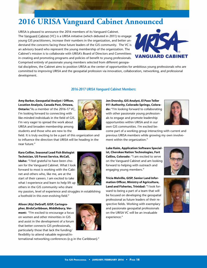
2016 URISA Vanguard Cabinet AnnouncedURISA is pleased to announce the 2016 members of its Vanguard Cabinet. The Vanguard Cabinet (VC) is a URISA initiative (which debuted in 2011) to engage young GIS practitioners, increase their numbers in the organization, and better un-derstand the concerns facing these future leaders of the GIS community. The VC is an advisory board who represent the young membership of the organization. The Cabinet’s mission is to collaborate with URISA’s Board of Directors and Committees in creating and promoting programs and policies of benefit to young professionals.Comprised entirely of passionate young members selected from different geospa-tial disciplines, the Cabinet aims to position URISA as the center of opportunities for ambitious young professionals who are committed to improving URISA and the geospatial profession via innovation, collaboration, networking, and professional development.
2016-2017 URISA Vanguard Cabinet Members:
Amy Barker, Geospatial Analyst / Officer, Location Analysis, Canada Post, Ottawa,
Ontario:”As a member of the 2016-17 VC, I’m looking forward to connecting with like-minded individuals in the field of GIS. I’m very eager to spread the work about URISA and broaden membership among students and those who are new to the field. It is truly exciting to be a part of this organization and to influence the direction that URISA will be heading in the near future.”
Kara Collier, Seasonal Lead Fish Biologist Technician, US Forest Service, McCall,
Idaho: “I feel grateful to have been cho-sen for the Vanguard Cabinet. What I look forward to most is working with the Cabi-net and others who, like me, are at the start of their careers. I am excited to take what I experience and learn to help lift up others in the GIS community who share my passion, level of experience and struggles in establishing a foothold in this ever-evolving field.”
Alison (Aly) DeGraff, GISP, Cartogra-pher, BirdsCaribbean, Middlebury, Ver-
mont: “I’m excited to encourage a focus on women and other minorities in GIS and assist in the development of a forum that better connects GIS professionals, particularly those that lack the funding/flexibility to attend valuable regional/in-ternational networking conferences (e.g in the Caribbean).”
Jen Dvorsky, GIS Analyst, El Paso Teller 911 Authority, Colorado Springs, Colora-
do: “I’m looking forward to collaborating with other passionate young profession-als to engage and promote leadership opportunities within URISA and in our own GIS communities. I’m excited be-come part of a working group interacting with current and previous URISA members while growing my own involve-ment within the organization.”
Luke Kaim, Application Software Special-ist, Cherokee Nation Technologies, Fort
Collins, Colorado: “I am excited to serve on the Vanguard Cabinet and am looking forward to helping with outreach and engaging young members.”
Tricia Melville, GISP, Senior Land Infor-mation Officer, Ministry of Agriculture,
Land and Fisheries, Trinidad: “I look for-ward to being a part of a team that will be focused on developing the geospatial professional as future leaders of their re-spective fields. Working with exemplary and passionate geospatial professionals on the URISA VC will be an invaluable experience.”
The GIS Professional • JANUARY/FEBRUARY 2016 • Page 18
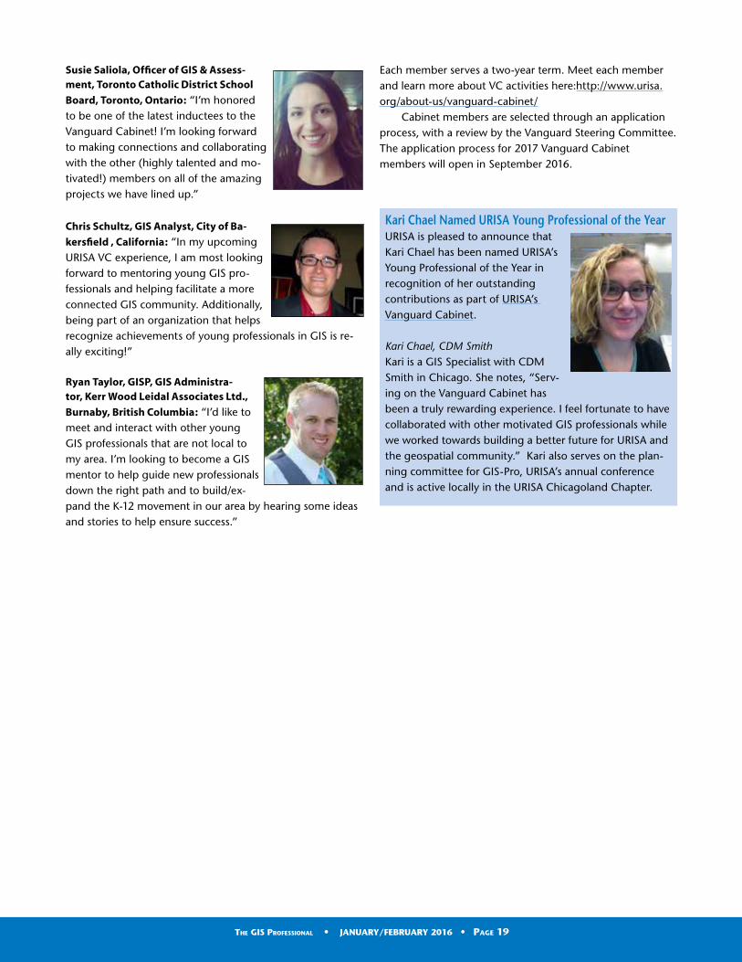
Kari Chael Named URISA Young Professional of the YearURISA is pleased to announce that Kari Chael has been named URISA’s Young Professional of the Year in recognition of her outstanding contributions as part of URISA’s Vanguard Cabinet.
Kari Chael, CDM SmithKari is a GIS Specialist with CDM Smith in Chicago. She notes, “Serv-ing on the Vanguard Cabinet has been a truly rewarding experience. I feel fortunate to have collaborated with other motivated GIS professionals while we worked towards building a better future for URISA and the geospatial community.” Kari also serves on the plan-ning committee for GIS-Pro, URISA’s annual conference and is active locally in the URISA Chicagoland Chapter.
Susie Saliola, Officer of GIS & Assess-ment, Toronto Catholic District School
Board, Toronto, Ontario: “I’m honored to be one of the latest inductees to the Vanguard Cabinet! I’m looking forward to making connections and collaborating with the other (highly talented and mo-tivated!) members on all of the amazing projects we have lined up.”
Chris Schultz, GIS Analyst, City of Ba-
kersfield , California: “In my upcoming URISA VC experience, I am most looking forward to mentoring young GIS pro-fessionals and helping facilitate a more connected GIS community. Additionally, being part of an organization that helps recognize achievements of young professionals in GIS is re-ally exciting!”
Ryan Taylor, GISP, GIS Administra-tor, Kerr Wood Leidal Associates Ltd.,
Burnaby, British Columbia: “I’d like to meet and interact with other young GIS professionals that are not local to my area. I’m looking to become a GIS mentor to help guide new professionals down the right path and to build/ex-pand the K-12 movement in our area by hearing some ideas and stories to help ensure success.”
Each member serves a two-year term. Meet each member and learn more about VC activities here:http://www.urisa.org/about-us/vanguard-cabinet/
Cabinet members are selected through an application process, with a review by the Vanguard Steering Committee. The application process for 2017 Vanguard Cabinet members will open in September 2016.
The GIS Professional • JANUARY/FEBRUARY 2016 • Page 19


As I write this (December 2015), there is major (historic, ac-cording to the news) flooding near St. Louis.
I remember sharing our GIS data with the vendor who was updating the floodplain maps for Pennsylvania. I wanted to ensure that the update was the best possible. Our 3-D models were the best available and we shared that, the parcels, jurisdiction boundaries, hydro, etc. Toward the end of the project they had some public meetings scheduled to review the work. We examined many of the proposed updates and had more questions than answers. We asked about the data sources and procedures used to update the maps and frankly did not receive many good answers. It seemed more like a “zero sum game”. If they added two acres to the floodplain in one area they would take two acres away somewhere else, saying “hydraulic models were used for the calculations.”
Finally we shared some historic flooding data that we had entered into our GIS. We were told, “historic data is not something they use to update the floodplain maps”! What?
What exactly is the role of historic flood data and the floodplain maps? Do you capture it in your GIS? Historic floodplain data might be aerial photography showing the flooding, pictures taken of floodwaters from a known location and compiled maps showing the extent of flooding produced in the GIS. Because the water is always moving, getting pictures of high water across a large area and synchronizing them may be difficult with so many other things that need to be done in an emergency.
The answer is metadata and “Post-it-Note” type fields. Exactly where was this photograph taken? What is the building’s address?
Is there a high water mark available? How deep is the water at a known landmark location (NE corner of the building) on the site? We should have this photo tied to the GIS with metadata readily available for subsequent use. If we had many photos like this available after an event and any aerial photography we could construct a high water flood map for an area.
A Post-it-Note field is a relational table that can be attached to just about any relational table or entity. Key information/locational data needs to be captured. Which staffer added the field? What was the date? Are there any keywords associated with the note? Allow for the entry of
any amount of free-field text which may prove valuable later on. Allow for the inclusion of photographs (street level), older pictures (historic land use), videos, text documents, news stories, etc.
If the Post-it-Note fields are not used for floodplain delineations then they might help determine which streets may be closed if the water gets any higher. Great for prepositioning barricades and emergency traffic signs and barriers. This is particularly important as a multi-day flooding event plays itself out.
Think of GIS as being the multi-media framework for organizing all sorts of data/information and content in the future. Think of all the operational data that could also be attached to GIS in the future?• Unstable slopes• Inspection data• Assessment data, valuation, owner, taxes• Underground tanks• Deeds, permits, instrument numbers• Land use/land cover• Bridge abutments—pre-event conditions• Variances and conditional uses• Utility data and routes
Questions/comments? [email protected]
Water, Water Everywhere! (Except in Some Places)By Peirce Eichelberger, Executive Consultant, geographic Data Base Management Systems, Inc.
The GIS Professional • JANUARY/FEBRUARY 2016 • Page 21

URISA, in partnership with the Ameri-can Public Health Association (APHA), invites abstract submissions for the 2016 GIS and Health Symposium. The theme for this year’s Symposium is “Mapping the Way to Healthy Commu-nities”. The event will take place June 1-3, 2016 in Washington, DC.
Abstract submissions are due on March 15, 2016.
The Symposium program will be de-veloped, in large part, from abstracts submitted by the community through this Call. The Committee welcomes the submission of individual papers, com-plete sessions, and panel discussions on a variety of topics. We are specifically interested in abstracts related to the following topics. • Connecting health with spatial
relationships (and data) - thinking about health in a more spatial format
• Tools for policy-makers, planners, researchers.
• Role of GIS in communicating health information/issues
• Health impact assessments• Metrics/measuring health
outcomes through GIS• Creating synergy between the
public health realm and urban and regional entities carrying out planning, research and policy.
• Focused policy session – cross-sector session addressing the Surgeon General’s National Prevention Strategy “Health in All Policies” approach
• Access to healthcare / health facilities and services
• Agriculture and food systems (access to healthy foods, food safety)
Call for Abstracts Announced for 2016 URISA GIS and Health SymposiumMapping the Way to Healthy Communities
• Active living, recreation, and physical activity from transportation; obesity strategies and interventions
• Health equity (include income considerations, minority groups, aging, persons with disabilities, etc.)
• Urban ecology/urban health – natural and human systems (social ecology; humans and environment)
• Climate change/resiliency - effects on natural and human health/systems
• Emergency preparedness and response
• Health and hazards• Crime, violence, personal safety/
health• Injuries, disabilities, risk• Built environment – land
use, transportation, resource management systems, Complete Streets, infrastructure, “Healthy Communities” (Applying GIS to Build a Healthy Community); also livability; active communities (transportation and recreation)
• Epidemiology; disease vectors; spread of infectious diseases – emerging technologies and health issues (Ebola response, Zika virus/PAHO)
• Exposures (air quality, water quality, lead, etc.)
• Chronic diseases and the environment, including cancers, diabetes and obesity
• Mobile field data collection mobile field data collection (examples: homeless point in time counts, food safety/restaurant inspections, facility inspections that includes things like hospitals, nursing homes, foster care sites, etc.)
• Community mapping; crowd-sourcing health-related data
• Data privacy, confidentiality• Other related topics
Individuals will be asked to further clas-sify their proposal by indicating the applied methods and data sources for each submission:• Basic statistical or GIS-based
analysis• Multivariate statistical models or
mathematical models• Spatial modeling and cluster
detection• Web-based delivering of data• Mapping techniques• Geocoding• Surveys, vital statistics or census
data• Surveillance data• Environmental spatial data• Network analysis and site
optimization• GPS, handheld/mobile device, and
other data collection tools• Remote sensing• Other
For further details and the online ab-stract submission form, http://www.urisa.org/URISAHealth
The GIS Professional • JANUARY/FEBRUARY 2016 • Page 22

2016 Partner Directory
Platinum CorporatePartners
Esri
380 New York St, Redlands, CA 92373
Phone: (909) 793-2853
Since 1969, Esri® has been helping
organizations map and model our world.
Esri’s GIS software tools and methodolo-
gies enable them to effectively analyze
and manage their geographic informa-
tion and make better decisions. They
are supported by our experienced and
knowledgeable staff and extensive
network of business partners and inter-
national distributors.
A full-service GIS company, Esri supports
the implementation of GIS technology on
the desktop, servers, online services, and
mobile devices. These GIS solutions are
flexible, customizable, and easy to use.
Esri software is used by hundreds of
thousands of organizations who apply
GIS to solve problems and make our
world a better place to live. We pay
close attention to our users to ensure
they have the best tools possible to
accomplish their missions. A compre-
hensive suite of training options offered
worldwide helps our users fully leverage
their GIS. Esri is a socially conscious busi-
ness, actively supporting organizations
involved in education, conservation,
sustainable development, and humani-
tarian affairs.
Hexagon Geospatial
5051 Peachtree Corners Circle
Norcross, GA 30092-2500 USA
Phone: +1 770 776 3400
Toll Free: + 1 877 463 7327
E-mail: geospatial@hexagongeospatial.
com
Website: http://www.hexagongeospa-
tial.com Hexagon Geospatial helps you
make sense of the dynamically changing
world. Hexagon Geospatial provides
geospatial technology products and
platforms to our customers, channel
partners, and Hexagon businesses.
Gold Corporate Partners
Cyclomedia Technology, Inc.
1250 I-Newell Ave., Suite 160
Walnut Creek, CA 94596
Phone: 800-790-3652
Email: [email protected]
www.cyclomedia.com
www.thedrivingdutchman.com
Cyclomedia is the market leader in sys-
tematic imaging of large-scale environ-
ments from cities to complete countries.
Cyclomedia’s smart imagery solution
creates Cycloramas – 360-degree pan-
oramic photos – with high accuracy,
providing current and clear views of
street-level environments.
The Cyclomedia recording system is like
no other. It uses patented technology to
determine the exact position and orien-
tation of every picture taken. By creating
a dense network of geometric street
images, Cycloramas are always focused
on the correct address or feature from
multiple vantage points.
Our solution revolutionizes the way asset
and property assessment is managed
and reported. It reduces field visits and
provides accurate feature measurements
with convenient spot-checking. It simpli-
fies maintenance and enables automated
inventory and controlled processes.
It also saves valuable resources while
simplifying the decision-making process,
improving operations and increasing
efficiency.
We provide ready-made solutions
throughout Europe, North America,
and Asia. Our technology is widely used
in government GIS, public safety, and
security markets, as well as in construc-
tion, infrastructure management, and
insurance.
We provide a full range of services
related to 3D mobile mapping. Data is
captured and delivered worldwide.
Our primary market segments include:
• Property Taxation, Appraisal, and
Building Inspection
• Transportation and Infrastructure
Management
• Public Safety and Homeland Security
• Engineering and Construction Plan-
ning
Cyclomedia offers the following licensed
products:
Content
• Cycloramas – Seamless, accurate 360°
panos taken at street-level with our
patented recording technology.
Viewer Software
• GlobeSpotter – Our feature-rich web
app for viewing Cycloramas that runs
on any browser supporting Flash.
• GlobeSpotter for ArcGIS Desktop –
The power of GlobeSpotter inside
Esri’s leading GIS software.
Hosting Solutions
• GlobeSpotter Cloud – Secure, scalable
hosting service managed by Cyclom-
edia that’s free to customers.
• GlobeSpotter Server – Locally hosted
option supporting all Cyclomedia’s
content and software.
Developer Tools
• GlobeSpotter API – Integrate GlobeS-
potter components into your user’s
existing business workflow.
• Panoramic Rendering Service – Ex-
tract pictures for reports and texture
map buildings with Cycloramas.
Silver Corporate Partners
Data Transfer Solutions
3680 Avalon Park Blvd East, Suite 200,
Orlando, FL 32828
Phone: (407) 382-5222
Headquartered in Orlando, DTS is a leader
in asset management, geographic infor-
mation systems, and transportation plan-
ning. We specialize in creating solutions to
help clients automate their worlds, reduce
their workload and organize their data
through customized technology.
DTS is comprised of seven divisions, each
with its own scope of services. Often
however, a single project spans several
The GIS Professional • JANUARY/FEBRUARY 2016 • Page 23
divisions before completion because we
uniquely offer all the necessary cutting-
edge services, integrated within one
company.
EagleView Technologies
3700 Monte Villa Pkwy, Ste 200
Bothell, WA 98021
1-855-984-6590
EagleView Technologies offers Pictom-
etry® Intelligent Images®. The high-
resolution oblique and ortho images are
captured and processed with patented
technology and delivered through in-
novative analytical tools to allow for the
most accurate assessment of properties.
Used daily by GIS, assessment, public
safety, defense, insurance, construction
and utility professionals, Pictometry
solutions bring field work to the desktop.
Solutions are easily integrated into
existing workflows through strategic
partnerships and make it easy for users
to make informed decisions and enhance
productivity. To find out more please
visit www.eagleview.com
Every day, new applications for Pictome-
try are realized. Discover how Pictometry
can help you work better, faster, smarter
and with optimal cost savings.
Bronze Corporate Partners
Blue Marble Geographics
77 Water Street
Hallowell, Maine 04347
1-800-616-2725
For over two decades, Blue Marble Geo-
graphics has been at the forefront of the
GIS data processing software business.
Pioneering work in geomatics and spatial
data conversion quickly established this
Maine-based company as a key player in
the GIS software field. Today GIS profes-
sionals are turning to Blue Marble for
Global Mapper a low cost, easy to use yet
powerful GIS software tool that everyone
can afford and use. Blue Marble is known
for coordinate conversion and file format
expertise and is the developer of Geo-
graphic Calculator, GeoCalc SDK, Global
Mapper and Global Mapper SDK.
North West Group
245 Aero Way NE
Calgary, Alberta, Canada, T2E 6K2
Phone: (403) 295-0694
Part of Hexagon, North West Group is
comprised of North West Geomatics
Ltd. (NWG) and Valtus Imagery Ser-
vices. NWG is a leading aerial data acqui-
sition company, dedicated to producing
high-quality digital aerial imagery
and related spatial data, while Valtus
provides an easy and reliable storage,
management and distribution solution
for imagery data.
Thomson Reuters
510 East Milham Ave.
Portage, MI 49002
Phone: 866.471.2900
www.thomsonreuters.com
Thomson Reuters is the world’s leading
source of intelligent information for gov-
ernments, businesses, and professionals,
combining industry expertise with
innovative technology to deliver critical
information to leading decision makers.
Our integrated Government Revenue
Management (GRM) suite offers end-
to-end software with services to ensure
revenue through land and property tax
administration. Meeting the needs of
emerging economies, OpenTitleT is an af-
fordable registry and cadastre tool with
an all-inclusive approach to collecting,
documenting, and recording the docu-
mentary and geographic information
relating to property rights. At Thomson
Reuters, our goal is to use state-of-the-
art technology to develop and deliver
sustainable tax and land administration
solutions on time, within budget and
configured to client requirements.
VESTRA
5300 Aviation Drive, Redding, CA 96002
Phone: (530) 223-2585
As a leader in GIS/IT, Environmental
Solutions, Engineering, and Surveying,
VESTRA has the depth of know-how
and experience to help clients achieve
success. VESTRA, an employee-owned
corporation dating back to 1988, prides
itself on our local presence and commit-
ment to the community. Our mission is to
be our clients’ most-valued consultant by
providing cost-effective, innovative, and
technically superior project solutions.
Whatever your current or future needs,
VESTRA’s full-service resources are avail-
able to support you on your next critical
project.
Business Partners
eGIS Associates, Inc.
2712 Wilding Green Lane, Suite 100
Dacula, Georgia 30019, USA
Phone: +1 678-710-9710
eGIS Associates, Inc. is focused on
providing efficient and cost effective
Geospatial Solutions that meet the
growing needs of public and private
sector enterprises. Our mission is to
help you consume the “Power of Place”
with current technology standards and
Applied Spatial Intelligence ©. eGIS
offers a wealth of professional products
and services including: Enterprise GIS
Implementation, Application Develop-
ment, Business Systems Integration and
Geospatial Training and Support. eGIS
is committed to customer satisfaction –
Relationships Matter. Whether you need
advice on your project or are looking for a
relevant product or just have a technical
question, contact us today.
geographIT
geographIT® offers the depth of experi-
ence, insight, and innovation that only
comes from more than two decades
of GIS consulting, custom software
development, and system integration
projects successfully completed for
state and local governments, utilities,
transportation, and law enforcement
sectors. Technologies have changed
significantly since the early days of GIS,
allowing for tightly coupled GIS/IT sys-
tem integration, deployment on multiple
platforms, and quicker implementation
of cost-effective solutions. Founded in
1990 as Advanced Technology Solutions
Inc., we were a pioneering GIS consult-
ing company in Pennsylvania when GIS
commercialization was still in its infancy.
We rebranded as geographIT in 2007 to
highlight our comprehensive and com-
petitive offering of geospatial services
2016 Partner Directory (continued)
The GIS Professional • JANUARY/FEBRUARY 2016 • Page 24

and solutions. Contact us today (market-
[email protected]) if you are looking
to start GIS or improve the efficiency of
your legacy GIS and IT systems.
GeoTechVision
With offices in Kingston, Jamaica (876-
970-5686) and Georgetown, Guyana
(592-227-0433)
www.geotechvision.com
GeoTechVision focuses on “Delivering
Value through Innovative Solutions!”
We have been assisting Caribbean
Businesses, Agencies and Government
Ministries to develop and effectively
use spatial intelligence in critical deci-
sion making! We are very involved with
establishing Geographic Information
Systems, GPS and Mobility products
and solutions, as well as marketing our
own “GeO” brand tablet. We consider
Human Capacity Building as very critical
- right from the classroom to the work
environment. Hence our Classroom
Management Solution and our strong
focus on Training and Development in all
our engagements. Our other consulting
services include Project Management,
Information Security Advisory, Process
Audit and Assurance, Business Analysis
and Enterprise GIS solution planning and
Implementation.
MGP
701 Lee Street Suite 1020
Des Plaines, IL 60016
Tel: (847) 656-5698
www.mgpinc.com
MGP is an information systems services
company that specializes in geo-spatial
solutions. Our comprehensive range of
geographic, data modeling, and business
process solutions provide you new op-
portunities to find a better way. We believe
that innovation creates opportunity and
collaboration breeds success. MGP was
formed as a shared business model in
which clients are partners. This philosophy
enables significant cost savings and makes
it possible for any client, regardless of size,
to get where they need to go. MGP is the
managing partner of the GIS Consortium.
Open Spatial Corporation
5701 Lonetree Blvd, Suite 109
Rocklin, CA 95765
(800) 696-1238
Contact: Colin Hobson
Open Spatial is a multi-national company
delivering geospatial solutions based
on Oracle and Autodesk technologies.
Recognized for delivering applications
to government and utility sectors, our
solutions are based on internationally
accepted open standards and world-class
best practices. Open Spatial offers in-
novative spatial infrastructure solutions
to managing spatial data from survey
through to design, construction and
ongoing spatial data management. Our
clients efficiently manage cadastre,
water, wastewater, stormwater, roads,
electric and fiber networks.
Planning Communities, LLC
9131 Anson Way, Suite 304
Raleigh, North Carolina 27615
919-803-6862 (Office)
919-882-1206 (Fax)
Planning Communities, LLC provides
a wide range of multi-disciplinary
planning services for local, state and
federal agencies, tribal nations and
community organizations. Community,
transportation, environmental and GIS
services include local/regional planning,
visioning/scenario planning, land use,
socioeconomic, market and cost-benefit
analysis, community asset mapping,
tool/application support and develop-
ment, process improvement/integration,
consensus-building and facilitation.
Headquartered in Raleigh, North Carolina,
Planning Communities has additional
offices in Charlotte (NC) and Seattle (WA).
Planning Communities is a North Carolina
certified Small Professional Service Firm
(SPSF) and is certified as a DBE in North
Carolina, Tennessee, Florida and Delaware.
Sani - International Technology Advisors Inc. (SANI-ITA)
Sani - International Technology Advi-
sors Inc. (SANI-ITA) is a privately owned
Canadian company with its head office
located in Ontario. The Corporation is
a business partner and reseller of BAE
Systems Geospatial eXploitation Prod-
ucts (GXP), TerraGo GeoPDF products,
ImageSat products and Leica Geosystems
products.
Temporal Geo Analytics
P.O. Box 181431
Denver, CO 80218
Phone: 720-235-0390
Temporal Geo Analytics, Inc. (TGA) is a Land Use and Environmental Litigation consulting firm. We have expertise in us-ing Geographic Information Systems (GIS) to develop, manage, and distribute com-plex spatial databases, as well as creating the presentation-quality visualizations and graphics needed for natural resource litigation and land use projects.
TGA specializes in the analysis of multi-faceted land use issues and environmen-tal impacts over time. TGA is expert at acquiring and integrating historic and current spatial data to build the critical information you need to represent your case.
Using GIS, we transform complex issues into defensible, authoritative, and easily understood maps and graphics. Our clien-tele consists primarily of natural resource and environmental attorneys, oil and gas companies, mining companies, and land developers.
2016 Partner Directory (continued)
The GIS Professional • JANUARY/FEBRUARY 2016 • Page 25

For information about URISA Partnership, please visit:
http://www.urisa.org/about-us/become-a-urisa-partner/ or contact Wendy Nelson at URISA Headquarters.
Leveraging GIS for Environmental, Natu-ral Resource, and Land Use Planning is our core expertise. Geographic Informa-tion Systems (GIS) integrate and overlay unlimited layers of themed spatial and tabular data to illustrate and reveal pat-terns, context, and the intrinsic qualities of any location. A GIS is also a powerful analysis tool capable of querying data for location and its relationship to overall context. At TGA, we have an intimate understanding of these tools and their capabilities.
Working with you and other experts, we build a completely defensible, dynamic analysis data platform with interactive visualizations and related tables that clearly represent the qualities of your project and its relationship to larger
political, environmental, and regional
contexts.
Wellar Consulting
Ottawa, ON Canada
Phone: (613) 728-3483
Wellar Consulting services include design
and evaluation of education and train-
ing courses and currricula for GISystems
and GIScience programs; advice and
workshops on the development of quan-
titative measures to assess information
system and transportation system per-
formance; critical reviews of IS and GIS
RFPs; seminars on the safety and security
aspects of interdependent infrastruc-
tures; professional opinion on land use
planning and zoning issues; and, expert
opinion on liability for safety-related
incidents involving pedestrians, cyclists,
and motor vehicle operators.
Federal Agency Sponsor
U.S. Census Bureau
4600 Silver Hill Road, Washington, DC
20233
The Census Bureau serves as the leading
source of quality data about the nation’s
people and economy. We honor privacy,
protect confidentiality, share our expertise
globally, and conduct our work openly. We
are guided on this mission by our strong
and capable workforce, our readiness to
innovate, and our abiding commitment to
our customers.
Educational InstitutionMembers
University of Southern California Spatial Sciences Institute• Spatial Studies minor,
B.S. in GeoDesign, and Geographic Information Science and Technology Graduate Programs
• Geographic Information Science and Technology (GIST) online graduate programs
• Graduate Certificate in Geospatial Leadership
University of Washington Tacoma, Urban Studies• Master of Science in
Geospatial Technologies• Certificate in
Geographic Information Systems (GIS)
2016 Partner Directory (continued)
The GIS Professional • JANUARY/FEBRUARY 2016 • Page 26

Mark Your Calendar!
June 1-3, 2016URISA GIS and Health SymposiumWashington, DC
August 1-5, 2016URISA Leadership AcademyChicago, Illinois
September 5-8, 2016URISA’s 2016 Caribbean GIS Conference Barbados
October 31-November 3, 2016GIS-Pro 2016: URISA’s 54th Annual Conference Toronto, Ontario Canada
PRESIDENTRebecca Somers, GISP— Somers-St. Claire GIS Management Consultants (Virginia)[email protected]
PRESIDENT-ELECTTripp Corbin, GISP— eGIS Associates, Inc. (Georgia)[email protected]
IMMEDIATE PAST-PRESIDENTCarl Anderson, GISP—Create I.O. (Florida)[email protected]
SECRETARYAshley Hitt, GISP–Connected Nation (Kentucky)[email protected]
TREASURERMartin Roche, GISP –Geo Planning Services LLC (Florida)[email protected]
JJochen Albrecht–Hunter College (New York)[email protected]
Stephen Berry, GISP Clark County Consortium for GIS (Kentucky)[email protected]
Keri Brennan, GISP—The Schneider Corporation (Indiana)[email protected]
Amy Esnard, GISP— Elevon Solutions (Oregon)[email protected]
Valrie Grant GISP—GeoTechVision (Jamaica)[email protected]
Corey Halford, GISP —City of Airdrie (Alberta Canada)[email protected]
Kevin Mickey, GISP—The Polis Center-IUPUI (Indiana)[email protected]
Non-Voting Board Member/Chapter Advisory Board Chair:Chris Akin, GISP – Representing New England [email protected]
THE GIS PROFESSIONALA publication of URISA – Fostering Excellence in GIS.URISA is a non-profit professional and educational association that promotes the effective and ethical use of spatial information and information technologies for the understanding and management of urban and regional systems. It is a multidisciplinary association where professionals from all parts of the spatial data community can come together and share concerns and ideas.
URISA Headquarters701 Lee Street, Suite 680Des Plaines, IL 60016Phone (847) 824-6300Fax (847) 824-6363 [email protected]
Submissions
Managing Editor – Wendy Nelson, Executive Director, [email protected]
RFP Distribution
URISA members, remember that URISA will distribute your RFP/RFQ announcements to our corporate and business members at no charge. Simply email your announcement to [email protected] (Subject: RFP Service) and we’ll send it right out for you!