The geochemistry of groundwater on Salt Spring Island, British Columbia...
8
The geochemistry of groundwater on Salt Spring Island, British Columbia, Canada Pat Lapcevic British Columbia Ministry of Environment, Nanaimo, British Columbia, Canada Angela Kingerlee, Greg Bickerton & Vicki Carmichael British Columbia Conservation Foundation, Nanaimo, British Columbia, Canada Water Science and Technology Directorate, Environment Canada, Burlington, Ontario, Canada British Columbia Ministry of Environment, Victoria, British Columbia, Canada ABSTRACT Salt Spring Island is the largest and most populous of the Gulf Islands located in the Georgia Strait between Vancouver Island and the mainland in British Columbia. Like most of the Gulf Islands and parts of Vancouver Island, groundwater from the Upper Cretaceous Nanaimo Group of sandstone, conglomerate and shale formations is a primary source of potable water for thousands of residents on Salt Spring Island. While the ambient quality of the groundwater from Nanaimo Group sediments is generally acceptable when compared to the Guidelines for Canadian Drinking Water Quality (GCDWQ), several studies have detected higher than acceptable levels of arsenic, fluoride, boron, iron and manganese. In this study, the geochemistry of the groundwater in fractured rock aquifers was examined by obtaining samples from 146 private wells on the island. The samples were analysed for a suite of chemical constituents and bacteria. Preliminary results indicate that 9% of the samples showed dissolved arsenic concentrations greater than the GCDWQ standard of 10 μg/L and in 25% of all samples arsenic concentrations over 1 μg/L were detected. The occurrence of arsenic in the groundwater appears to be geologically controlled and can vary seasonally due to changes in contributing fractures. Bacterial analyses indicated greater than 10 total coliform CFU/100 mL in about 29% of all samples. Greater than 1 fecal coliform (CFU/100 mL) and Escherichia coli (E .coli), were noted in 10% and 9% of samples respectively. These results suggest that in addition to natural geologic and climatic conditions, well siting, construction practices, and proximity of wells to potential contamination sources may also be impacting the potability of the groundwater resource. RÉSUMÉ L’île de Salt Spring est la plus vaste et la plus peuplée des îles du golfe, dans le détroit de Géorgie, entre l’île de Vancouver et la partie continentale de la Colombie-Britannique, Canada. Comme pour la plupart des îles du golfe et pour certains secteurs de l’île de Vancouver, l’eau souterraine du Groupe Nanaimo, datant du crétacé supérieur et constitué de grès, de conglomérat et de formations de schiste argileux constitue une source primaire d’eau potable pour les milliers d’habitants de l’île de Salt Spring. Même si la qualité du milieu de l’eau souterraine du Groupe Nanaimo est généralement acceptable si on la compare aux recommandations pour la qualité de l’eau potable au Canada, plusieurs études ont permis de détecter des quantités plus élevées d’arsenic, de fluorure, de bore, de fer et de manganèse que les niveaux acceptables. Dans cette étude, on s’est penché sur la géochimie de l’eau souterraine dans les aquifères de roches fracturées, en prélevant des échantillons dans 146 puits privés de l’île. Les échantillons ont été analysés pour une série de constituants chimiques et de bactéries. Les résultats préliminaires indiquent que 9% des échantillons affichaient des concentrations d’arsenic dissous plus élevées que dans les recommandations pour la qualité de l’eau potable au Canada, qui sont 10 μg/litre et que cette concentration grimpait à 1 μg/litre dans 25% de tous les échantillons. La fréquence de la présence d’arsenic dans les eaux souterraines semble être contrôlée géologiquement et peut varier selon les saisons, en raison des variations dans les fractures qui contribuent à l’apport en eau. Des analyses bactériologiques ont révélé une quantité supérieure à 10 coliformes totaux, CFU/100 ml dans environ 29% de tous les échantillons. Une quantité supérieure à 1 coliforme fécal (CFU/100 ml) et à 1 Escherichia coli (E. coli) a été observée dans 10% et dans 9% des échantillons, respectivement. Ces résultats semblent indiquer qu’en plus des conditions géologiques naturelles et des conditions climatiques, des puits mal construits influencent également la potabilité des ressources en eaux souterraines. GeoEdmonton'08/GéoEdmonton2008 1257
Transcript of The geochemistry of groundwater on Salt Spring Island, British Columbia...

The geochemistry of groundwater on Salt Spring Island, British Columbia, Canada Pat Lapcevic British Columbia Ministry of Environment, Nanaimo, British Columbia, Canada
Angela Kingerlee, Greg Bickerton & Vicki Carmichael British Columbia Conservation Foundation, Nanaimo, British Columbia, Canada Water Science and Technology Directorate, Environment Canada, Burlington, Ontario, Canada British Columbia Ministry of Environment, Victoria, British Columbia, Canada
ABSTRACT Salt Spring Island is the largest and most populous of the Gulf Islands located in the Georgia Strait between Vancouver Island and the mainland in British Columbia. Like most of the Gulf Islands and parts of Vancouver Island, groundwater from the Upper Cretaceous Nanaimo Group of sandstone, conglomerate and shale formations is a primary source of potable water for thousands of residents on Salt Spring Island. While the ambient quality of the groundwater from Nanaimo Group sediments is generally acceptable when compared to the Guidelines for Canadian Drinking Water Quality (GCDWQ), several studies have detected higher than acceptable levels of arsenic, fluoride, boron, iron and manganese. In this study, the geochemistry of the groundwater in fractured rock aquifers was examined by obtaining samples from 146 private wells on the island. The samples were analysed for a suite of chemical constituents and bacteria. Preliminary results indicate that 9% of the samples showed dissolved arsenic concentrations greater than the GCDWQ standard of 10 µg/L and in 25% of all samples arsenic concentrations over 1 µg/L were detected. The occurrence of arsenic in the groundwater appears to be geologically controlled and can vary seasonally due to changes in contributing fractures. Bacterial analyses indicated greater than 10 total coliform CFU/100 mL in about 29% of all samples. Greater than 1 fecal coliform (CFU/100 mL) and Escherichia coli (E .coli), were noted in 10% and 9% of samples respectively. These results suggest that in addition to natural geologic and climatic conditions, well siting, construction practices, and proximity of wells to potential contamination sources may also be impacting the potability of the groundwater resource. RÉSUMÉ L’île de Salt Spring est la plus vaste et la plus peuplée des îles du golfe, dans le détroit de Géorgie, entre l’île de Vancouver et la partie continentale de la Colombie-Britannique, Canada. Comme pour la plupart des îles du golfe et pour certains secteurs de l’île de Vancouver, l’eau souterraine du Groupe Nanaimo, datant du crétacé supérieur et constitué de grès, de conglomérat et de formations de schiste argileux constitue une source primaire d’eau potable pour les milliers d’habitants de l’île de Salt Spring. Même si la qualité du milieu de l’eau souterraine du Groupe Nanaimo est généralement acceptable si on la compare aux recommandations pour la qualité de l’eau potable au Canada, plusieurs études ont permis de détecter des quantités plus élevées d’arsenic, de fluorure, de bore, de fer et de manganèse que les niveaux acceptables. Dans cette étude, on s’est penché sur la géochimie de l’eau souterraine dans les aquifères de roches fracturées, en prélevant des échantillons dans 146 puits privés de l’île. Les échantillons ont été analysés pour une série de constituants chimiques et de bactéries. Les résultats préliminaires indiquent que 9% des échantillons affichaient des concentrations d’arsenic dissous plus élevées que dans les recommandations pour la qualité de l’eau potable au Canada, qui sont 10 µg/litre et que cette concentration grimpait à 1 µg/litre dans 25% de tous les échantillons. La fréquence de la présence d’arsenic dans les eaux souterraines semble être contrôlée géologiquement et peut varier selon les saisons, en raison des variations dans les fractures qui contribuent à l’apport en eau. Des analyses bactériologiques ont révélé une quantité supérieure à 10 coliformes totaux, CFU/100 ml dans environ 29% de tous les échantillons. Une quantité supérieure à 1 coliforme fécal (CFU/100 ml) et à 1 Escherichia coli (E. coli) a été observée dans 10% et dans 9% des échantillons, respectivement. Ces résultats semblent indiquer qu’en plus des conditions géologiques naturelles et des conditions climatiques, des puits mal construits influencent également la potabilité des ressources en eaux souterraines.
GeoEdmonton'08/GéoEdmonton2008
1257
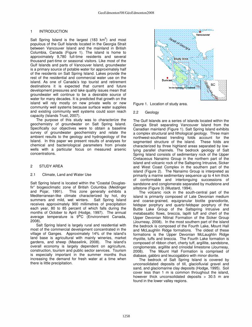
1 INTRODUCTION Salt Spring Island is the largest (183 km2) and most populous of the Gulf Islands located in the Georgia Strait between Vancouver Island and the mainland in British Columbia, Canada (Figure 1). The island is home to approximately 9,780 full-time residents and several thousand part-time or seasonal visitors. Like most of the Gulf Islands and parts of Vancouver Island, groundwater is a primary source of potable water for approximately half of the residents on Salt Spring Island. Lakes provide the rest of the residential and commercial water use on the island. As one of Canada’s top tourist and retirement destinations it is expected that current and future development pressures and lake quality issues mean that groundwater will continue to be a desirable source of water for many decades. It is predicted that growth on the island will rely mostly on new private wells or new community well systems because surface water supplies and existing community well systems could soon reach capacity (Islands Trust, 2007).
The purpose of this study was to characterize the geochemistry of groundwater on Salt Spring Island. Specifically our objectives were to obtain a baseline survey of groundwater geochemistry and relate the ambient results to the geology and hydrogeology of the Island. In this paper we present results of analyses for chemical and bacteriological parameters from private wells with a particular focus on measured arsenic concentrations. 2 STUDY AREA 2.1 Climate, Land and Water Use Salt Spring Island is located within the “Coastal Douglas-fir” biogeoclimatic zone of British Columbia (Meidinger and Pojar, 1991). This zone generally exhibits a Mediterranean-like climate characterized by hot, dry summers and mild, wet winters. Salt Spring Island receives approximately 900 millimetres of precipitation each year, 80 to 85 percent of which falls during the months of October to April (Hodge, 1997). The annual average temperature is 9�C (Environment Canada, 2008).
Salt Spring Island is largely rural and residential with most of the commercial development concentrated in the village of Ganges. Approximately 14% of the island’s land base is agricultural with mainly wineries, market gardens, and sheep (Masselink, 2008). The island’s overall economy is largely dependent on agriculture, construction, tourism and public sector services. Tourism is especially important in the summer months thus increasing the demand for fresh water at a time when there is little precipitation.
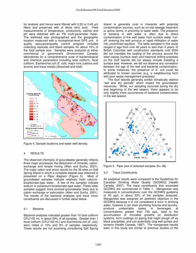
Figure 1. Location of study area. 2.2 Geology The Gulf Islands are a series of islands located within the Georgia Strait separating Vancouver Island from the Canadian mainland (Figure 1). Salt Spring Island exhibits a complex structural and lithological geology. Three main northwest-southeast trending folds account for the segmented structure of the island. These folds are characterized by three highland areas separated by low-lying parallel channels. The bedrock geology of Salt Spring Island consists of sedimentary rock of the Upper Cretaceous Nanaimo Group in the northern part of the island and volcanic rock of the Saltspring Intrusive, Sicker and West Coast Complex in the southern part of the island (Figure 2). The Nanaimo Group is interpreted as primarily a marine sedimentary sequence up to 4 km thick of conformable and intertonguing successions of sandstone and conglomerate separated by mudstone and siltstone (Figure 3) (Mustard, 1994).
The volcanic rock in the south-central part of the island is primarily composed of Late Devonian medium and coarse-grained, equigranular biotite granodiorite, feldspar porphyry and quartz-feldspar porphyry of the Buttle Lake Group of the Saltspring Intrusive and metabasaltic flows, breccia, lapilli tuff and chert of the Upper Devonian Nitinat Formation of the Sicker Group (Journeay, 2008). In the most southern part of the island the bedrock is composed of the Fourth Lake, Mount Hall and McLaughlin Ridge formations. The oldest of these formations is the Upper Devonian McLaughlin Ridge rhyolite, tuffs and breccia. The Fourth Lake formation is composed of ribbon chert, cherty tuff, argillite, sandstone, conglomerate, argillite and crinoidal limestone (Journeay, 2008). The Mount Hall Formation is comprised of diabase, gabbro and leucogabbro with minor diorite.
The bedrock of Salt Spring Island is covered by unconsolidated deposits of till, glaciofluvial gravel and sand, and glaciomarine clay deposits (Hodge, 1995). Soil cover less than 1 m is common throughout the island, however thick unconsolidated deposits > 30.5 m are found in the lower valley regions.
GeoEdmonton'08/GéoEdmonton2008
1258
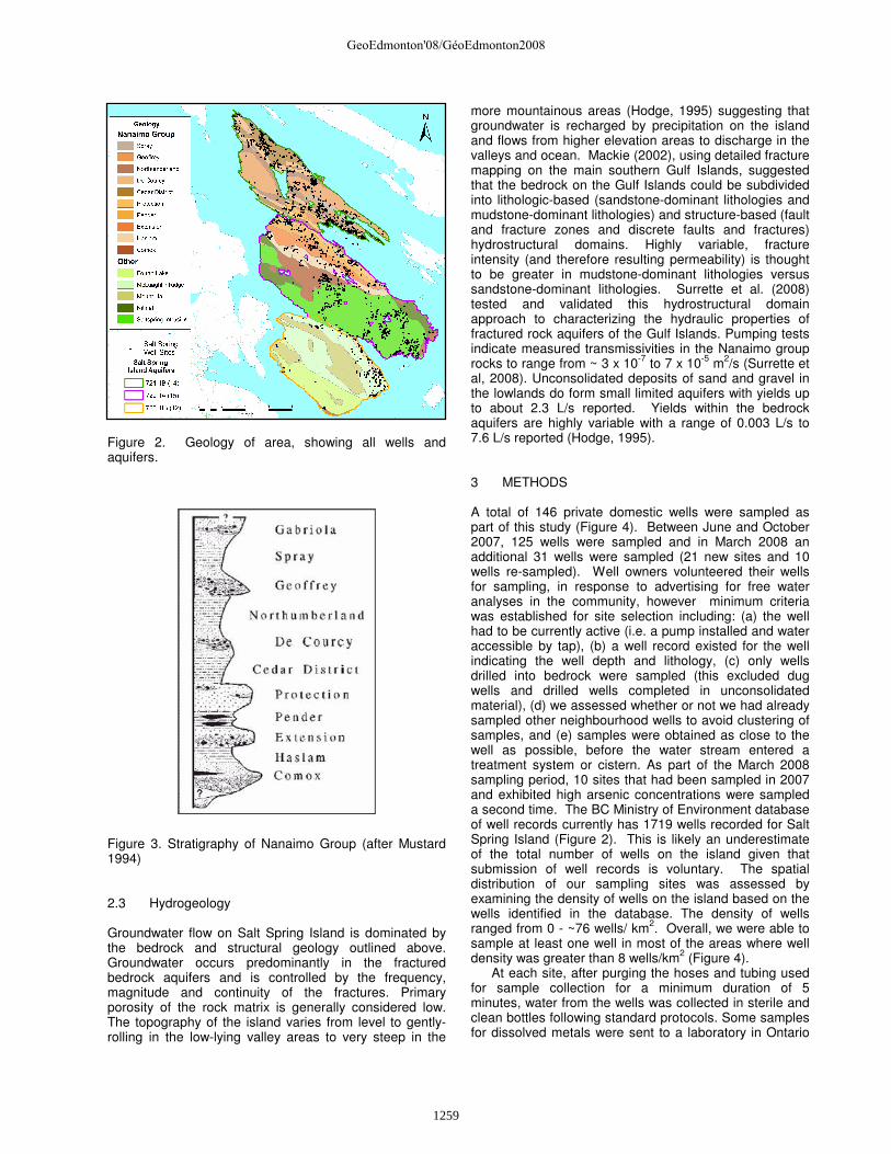
Figure 2. Geology of area, showing all wells and aquifers. Figure 3. Stratigraphy of Nanaimo Group (after Mustard 1994) 2.3 Hydrogeology Groundwater flow on Salt Spring Island is dominated by the bedrock and structural geology outlined above. Groundwater occurs predominantly in the fractured bedrock aquifers and is controlled by the frequency, magnitude and continuity of the fractures. Primary porosity of the rock matrix is generally considered low. The topography of the island varies from level to gently-rolling in the low-lying valley areas to very steep in the
more mountainous areas (Hodge, 1995) suggesting that groundwater is recharged by precipitation on the island and flows from higher elevation areas to discharge in the valleys and ocean. Mackie (2002), using detailed fracture mapping on the main southern Gulf Islands, suggested that the bedrock on the Gulf Islands could be subdivided into lithologic-based (sandstone-dominant lithologies and mudstone-dominant lithologies) and structure-based (fault and fracture zones and discrete faults and fractures) hydrostructural domains. Highly variable, fracture intensity (and therefore resulting permeability) is thought to be greater in mudstone-dominant lithologies versus sandstone-dominant lithologies. Surrette et al. (2008) tested and validated this hydrostructural domain approach to characterizing the hydraulic properties of fractured rock aquifers of the Gulf Islands. Pumping tests indicate measured transmissivities in the Nanaimo group rocks to range from ~ 3 x 10⁻⁷ to 7 x 10⁻⁵ m2/s (Surrette et al, 2008). Unconsolidated deposits of sand and gravel in the lowlands do form small limited aquifers with yields up to about 2.3 L/s reported. Yields within the bedrock aquifers are highly variable with a range of 0.003 L/s to 7.6 L/s reported (Hodge, 1995). 3 METHODS A total of 146 private domestic wells were sampled as part of this study (Figure 4). Between June and October 2007, 125 wells were sampled and in March 2008 an additional 31 wells were sampled (21 new sites and 10 wells re-sampled). Well owners volunteered their wells for sampling, in response to advertising for free water analyses in the community, however minimum criteria was established for site selection including: (a) the well had to be currently active (i.e. a pump installed and water accessible by tap), (b) a well record existed for the well indicating the well depth and lithology, (c) only wells drilled into bedrock were sampled (this excluded dug wells and drilled wells completed in unconsolidated material), (d) we assessed whether or not we had already sampled other neighbourhood wells to avoid clustering of samples, and (e) samples were obtained as close to the well as possible, before the water stream entered a treatment system or cistern. As part of the March 2008 sampling period, 10 sites that had been sampled in 2007 and exhibited high arsenic concentrations were sampled a second time. The BC Ministry of Environment database of well records currently has 1719 wells recorded for Salt Spring Island (Figure 2). This is likely an underestimate of the total number of wells on the island given that submission of well records is voluntary. The spatial distribution of our sampling sites was assessed by examining the density of wells on the island based on the wells identified in the database. The density of wells ranged from 0 - ~76 wells/ km2. Overall, we were able to sample at least one well in most of the areas where well density was greater than 8 wells/km2 (Figure 4).
At each site, after purging the hoses and tubing used for sample collection for a minimum duration of 5 minutes, water from the wells was collected in sterile and clean bottles following standard protocols. Some samples for dissolved metals were sent to a laboratory in Ontario
GeoEdmonton'08/GéoEdmonton2008
1259
for analysis and hence were filtered with 0.20 or 0.45 µm filters and preserved with of dilute nitric acid. Field measurements of temperature, conductivity, salinity and pH were obtained with an YSI multi-parameter meter. The wellhead was photographed and the geographic location measured with a recreational-level GPS unit. A quality assurance/quality control program included collecting replicate and blank samples for about 10% of the total sample size. Samples were analyzed at either commercial or government (Environment Canada) laboratories for a comprehensive suite of bacteriological and chemical parameters including total coliform, fecal coliform, Escherichia coli (E .coli), major ions (cations and anions) and trace metals (dissolved and total).
Figure 4. Sample locations and water well density. 4 RESULTS The observed chemistry of groundwater generally reflects three major processes: the dissolution of minerals, cation-exchange and simple mixing (Allen and Suchy, 2001). The major cation and anion results for the 36 sites on Salt Spring Island in which a complete dataset was obtained is presented on a Piper diagram (Figure 5). Most of groundwater samples indicate relatively fresh calcium-bicarbonate-type water. A few of the samples indicate sodium or potassium-bicarbonate-type water. These latter samples suggest more evolved groundwater likely due to cation exchange or salinization (Allen and Suchy, 2001). The results of the bacterial analyses and trace minor constituents are discussed in further detail below. 4.1 Bacteria Bacterial analyses indicated greater than 10 total coliform CFU/100 mL in about 29% of all samples. Greater than 1 fecal coliform (CFU/100 mL) and Escherichia coli (E .coli), were noted in 10% and 9% of samples respectively. These results are not surprising considering Salt Spring
Island is generally rural in character with potential contamination sources, such as on-site sewage treatment or active farms, in proximity to water wells. The presence of bacteria in well water is often due to direct contamination of the well water from surface water ‘run-off’ entering the well annulus or rapid infiltration of water into unconfined aquifers. The wells sampled in this study ranged in age from over 40 years to less than 3 years. In British Columbia well construction standards until 2005 did not mandate the sealing of the annulus around the steel casing (surface seal) and historical drilling practises on the Gulf Islands did not always include installing a surface seal. However, we did not observe any correlation between the age of the well and bacterial contamination. In some instances, the presence of E. coli could be attributed to known sources (e.g. a neighbouring farm with poor waste management practises).
The Gulf Islands generally exhibit climatically distinct “wet and dry periods” which impact the groundwater resources. While, our sampling occurred during the dry and beginning of the wet season, there appears to be only slightly more occurrences of bacterial contamination in the wet season.
Figure 5. Piper plot of selected samples (N= 36). 4.2 Trace Constituents All analytical results were compared to the Guidelines for Canadian Drinking Water Quality (GCDWQ) (Health Canada, 2007). The trace constituents that exceeded GCDWQ are summarized in Table 1. Manganese was measured in concentrations over the GCDWQ guideline of 50 µg/L in about 33% of the samples analyzed. Manganese was assigned an aesthetic objective in the GCDWQ because it is not considered a toxin in drinking water, however it can stain plumbing fixtures and laundry, produce undesirable tastes in beverages at concentrations greater than 150 µg/L, lead to the accumulation of microbial growths on distribution systems, form coatings on piping that might slough off as black precipitate, and can potentially clog well pumps and screens (Health Canada, 1987). The manganese results seen in this study are similar to previous studies of the
GeoEdmonton'08/GéoEdmonton2008
1260
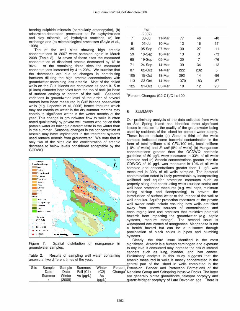
groundwater geochemistry on other Gulf Islands (Hornby and Saturna) (Allen and Matsuo (2001); Allen and Suchy (2001)). For example, Allen and Pelude (2001) concluded that it is likely that manganese exists in the local geology of both islands, and is contributed to the groundwater as a result of normal dissolution processes. The elevated concentrations of manganese found in some areas are likely the result of superimposed chemical processes, such as reduction-oxidation, that act to control the amount of dissolution that takes place. Figure 6 shows that, spatially, manganese in groundwater is found throughout Salt Spring Island in wells completed both in sedimentary and volcanic rocks.
Arsenic over the GCDWQ of 10 µg/L was measured in about 9% of all samples and is discussed further below. Other constituents that exceeded guidelines in 1-10% of all samples include fluoride and boron. These parameters are reflective of the host rock chemical composition. Major ions such as sodium, chloride, sulphate were also found above GCDWQ limits in less than 10% of samples but are not discussed further in this paper as interpretation of this data is still ongoing.
Figure 6. Spatial distribution of manganese in groundwater samples.
Table 1. Summary of results for selected parameters.
Parameter1 N2
Units
Minimum Detection
Limit GCDWQ3 Measured
Concentrations
Results equal to or
over GCDWQ
Min. Max. N24 % Manganese (Mn) 136 µg/L 0.05 50 <0.05 11200 45 33 pH 125 6.5-8.5 5.96 9.33 18 14 Arsenic (As) 136 µg/L 0.01 10 <0.01 1370 12 9 Iron (Fe) 134 mg/L 0.0009 0.3 <0.0007 2.95 5 4 Fluoride (F) 136 mg/L 0.004 1.5 <0.004 5.18 8 6 Boron (B) 133 mg/L 0.005 5 <0.005 41.80 6 5 Nitrate (NO3) 111 mg/L 0.002 45 <0.002 82.75 1 1
1Measured chemical parameters are dissolved concentrations 2Number of sites with reliable results (some water samples were not reflective of groundwater and excluded from analysis) 3Guidelines for Canadian Drinking Water Quality (Health Canada, 2007) 4Number of samples
4.3 Arsenic Arsenic concentrations as high as 1370 µg/L were measured in well water samples in this study. About 9% of all samples had concentrations above the GCDWQ of 10 µg/L and overall 25% showed concentrations over 1 µg/L. Previous studies of the geochemistry of the groundwater on other Gulf Islands have not identified arsenic as a concern (e.g. Allen and Suchy (2001); Earle and Krogh (2006)). However, since these studies were completed the GCDWQ standard for arsenic was lowered to 10 µg/L from 25 µg/L, necessitating more sensitive analyses. Arsenic has been detected in other regions of British Columbia at concentrations well above the GCDWQ (e.g. Boyle (1998); Carmichael and Clarkson
(1995); Mattu and Schreier (2000) and Zubel (2002)). Spatially, the higher arsenic (As) concentrations measured in groundwater on Salt Spring Island are mostly concentrated in a broad band trending northwest to southeast in the central third of the island (Figure 7). A second smaller region in the northern third of the island is evident as a band parallel to the first. In the first region, arsenic was measured in groundwater from wells that are completed in Nanaimo Group Sedimentary rock (primarily the Extension, Pender and Protection Formations) and a cluster of wells completed in Saltspring Intrusive Rocks. The latter are generally biotite granodiorite, feldspar porphyry and quartz-feldspar porphyry of Late Devonian age. The factors that control the concentration and mobility of As in groundwater include: (a) oxidation of As-
GeoEdmonton'08/GéoEdmonton2008
1261
bearing sulphide minerals (particularly arsenopyrite), (b) adsorption-desorption processes on Fe oxyhydroxides and clay minerals, (c) hydrolysis reactions, (d) ion exchange and (e) microbiological processes (Boyle et al., 1998).
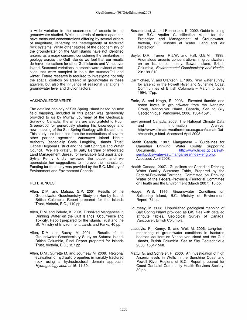
Ten of the well sites showing high arsenic concentrations in 2007 were sampled again in March 2008 (Table 2). At seven of these sites the measured concentration of dissolved arsenic decreased by 12 to 96%. At the remaining three sites the measured concentrations increased by 4 to 20%. We surmise that the decreases are due to changes in contributing fractures diluting the high arsenic concentrations with groundwater containing less arsenic. Most of the drilled wells on the Gulf Islands are completed as open 0.15 m (6 inch) diameter boreholes from the top of rock (or base of surface casing) to bottom of the well. Seasonal variations in groundwater level of the order of several metres have been measured in Gulf Islands observation wells (e.g. Lapcevic et al, 2006) hence fractures which may not contribute water in the dry summer months may contribute significant water in the wetter months of the year. This change in groundwater flow to wells is often noted qualitatively by private well owners who notice their potable water as having a different taste in the winter than in the summer. Seasonal changes in the concentration of arsenic may have implications in the treatment systems used remove arsenic from groundwater. We note that in only two of the sites did the concentration of arsenic decrease to below levels considered acceptable by the GCDWQ.
Figure 7. Spatial distribution of manganese in groundwater samples. Table 2. Results of sampling well water containing arsenic at two different times of the year.
Site Sample
Date Summer
/
Sample Date
Winter (2008)
Summer/ Fall (C1) As (µg/L)
Winter (C2) As
(µg/L)
Percent Change1
Fall (2007)
7 03-Jul 11-Mar 77 46 -40
8 03-Jul 10-Mar 12 16 37
35 05-Sep 07-Mar 30 27 -11
59 18-Sep 10-Mar 13 3 -73
65 19-Sep 05-Mar 30 7 -76
71 24-Sep 14-Mar 39 34 -12
87 02-Oct 14-Mar 222 232 5
105 15-Oct 18-Mar 392 14 -96
113 23-Oct 14-Mar 1370 183 -87
125 31-Oct 05-Mar 10 12 20
1Percent Change= (C2-C1)/C1 x 100 5 SUMMARY Our preliminary analysis of the data collected from wells on Salt Spring Island has identified three significant issues in relation to the quality of the groundwater being used by residents of the island for potable water supply. These issues include (a) About a third of the wells sampled indicated some bacterial contamination in the form of total coliform >10 CFU/100 mL, fecal coliform (10% of wells) and E. coli (9% of wells) (b) Manganese concentrations greater than the GCDWQ aesthetic guideline of 50 µg/L were measured in 33% of all wells sampled and (c) Arsenic concentrations greater that the CDWQG of 10 µg/L was measured in 10% of all wells sampled and concentrations greater than 1 µg/L was measured in 30% of all wells sampled. The bacterial contamination noted is likely preventable by incorporating wellhead and aquifer protection measures such as properly siting and constructing wells (surface seals) and well head protection measures (e.g. well caps, minimum casing stickup and floodproofing) to prevent the introduction of surface water to the interior of the well or well annulus. Aquifer protection measures at the private well owner scale include ensuring new wells are sited away from known sources of contamination and encouraging land use practises that minimize potential hazards from impacting the groundwater (e.g. septic systems, manure storage). The second issue is widespread occurrence of manganese. Manganese is not a health hazard but can be a nuisance through precipitation of black solids in pipes and plumbing systems.
Clearly, the third issue identified is the most significant. Arsenic is a human carcinogen and exposure to any level if consumed may increase the risk of internal cancers such as lung, bladder, and liver cancer. Preliminary analysis in this study suggests that the arsenic measured in wells is mostly concentrated in the central part of the island in wells completed in the Extension, Pender and Protection Formations of the Nanaimo Group and Saltspring Intrusive Rocks. The latter are generally biotite granodiorite, feldspar porphyry and quartz-feldspar porphyry of Late Devonian age. There is
GeoEdmonton'08/GéoEdmonton2008
1262
a wide variation in the occurrence of arsenic in the groundwater studied. Wells hundreds of metres apart can have measured concentrations differing by several orders of magnitude, reflecting the heterogeneity of fractured rock systems. While other studies of the geochemistry of the groundwater on the Gulf Islands have not identified arsenic as a major concern, considering the similarities in geology across the Gulf Islands we feel that our results do have implications for other Gulf Islands and Vancouver Island. Seasonal variations in arsenic were evident at well sites that were sampled in both the summer/fall and winter. Future research is required to investigate not only the spatial controls on arsenic in groundwater in these aquifers, but also the influence of seasonal variations in groundwater level and dilution factors.
ACKNOWLEDGEMENTS The detailed geology of Salt Spring Island based on new field mapping, included in this paper was generously provided to us by Murray Journeay of the Geological Survey of Canada. The writers are also grateful to Hugh Greenwood for generously sharing his knowledge and new mapping of the Salt Spring Geology with the authors. This study also benefited from the contributions of several other partner agencies: Vancouver Island Health Authority (especially Chris Laughlin), Islands Trust, Capital Regional District and the Salt Spring Island Water Council. We are grateful to Sally Bertram of Integrated Land Management Bureau for invaluable GIS assistance. Sylvia Kenny kindly reviewed the paper and we appreciate her suggestions to improve the manuscript. Funding for the study was provided by the B.C. Ministry of Environment and Environment Canada. REFERENCES Allen, D.M. and Matsuo, G.P. 2001 Results of the
Groundwater Geochemistry Study on Hornby Island, British Columbia. Report prepared for the Islands Trust, Victoria, B.C., 119 pp.
Allen, D.M. and Pelude, K. 2001. Dissolved Manganese in
Drinking Water on the Gulf Islands: Occurrence and Toxicity. Report prepared for the Islands Trust and the BC Ministry of Environment, Lands and Parks, 40 pp.
Allen, D.M. and Suchy, M. 2001. Results of the
Groundwater Geochemistry Study on Saturna Island, British Columbia, Final Report prepared for Islands Trust, Victoria, B.C., 127 pp.
Allen, D.M., Surrette M. and Journeay M. 2008. Regional
evaluation of hydraulic properties in variably fractured rock using a hydrostructural domain approach, Hydrogeology Journal 16: 11-30.
Berardinucci, J. and Ronneseth, K. 2002. Guide to using the B.C. Aquifer Classification Maps for the Protection and Management of Groundwater, Victoria, BC: Ministry of Water, Land and Air Protection.
Boyle, D.R., Turner, R.J.W. and Hall, G.E.M. 1998.
Anomalous arsenic concentrations in groundwaters on an island community, Bowen Island, British Columbia, Environmental Geochemistry and Health, 20: 199-212.
Carmichael, V. and Clarkson, L. 1995. Well water survey
for arsenic in the Powell River and Sunshine Coast Communities of British Columbia – March to June 1994, 17pp.
Earle, S. and Krogh, E. 2006. Elevated fluoride and
boron levels in groundwater from the Nanaimo Group, Vancouver Island, Canada, Sea to Sky Geotechnique, Vancouver, 2006, 1584-1591.
Environment Canada. 2006. The National Climate Data
and Information Archive, http://www.climate.weatheroffice.ec.gc.ca/climateData/canada_e.html. Accessed April 2008.
Health Canada. 1987. Manganese – Guidelines for
Canadian Drinking Water Quality Supporting Documents. http://www.hc-sc.gc.ca/ewh-semt/pubs/water-eau/manganese/index-eng.php. Accessed April 2008.
Health Canada. 2007. Guidelines for Canadian Drinking
Water Quality Summary Table, Prepared by the Federal-Provincial-Territorial Committee on Drinking Water of the Federal-Provincial-Territorial Committee on Health and the Environment (March 2007), 15 pp.
Hodge, W.S. 1995. Groundwater Conditions on
Saltspring Island, B.C. Ministry of Environment Report, 74 pp.
Journeay, M. 2008. Unpublished geological mapping of
Salt Spring Island provided as GIS files with detailed attribute tables, Geological Survey of Canada, Vancouver, British Columbia.
Lapcevic, P., Kenny, S. and Wei, M. 2006. Long-term
monitoring of groundwater conditions in fractured bedrock aquifers on Vancouver Island and the Gulf Islands, British Columbia. Sea to Sky Geotechnique 2006, 1561-1568.
Mattu, G. and Schreier, H. 2000. An Investigation of high
Arsenic levels in Wells in the Sunshine Coast and Powell River Regions of B.C., Report prepared for Coast Garibaldi Community Health Services Society, 89 pp.
GeoEdmonton'08/GéoEdmonton2008
1263
Mackie, D.C. 2002. An Integrated structural and hydrogeologic investigation of the fracture system in the Upper Cretaceous Nanaimo Group, Southern Gulf Islands, British Columbia, M.Sc. Thesis, Simon Fraser University, Burnaby, B.C.
Masselink Environmental Design. 2008. Salt Spring
Island Area Farm Plan Detailed Report, January 2008, http://www.islandstrust.bc.ca/ltc/ss/pdf/ssocpreviewareafarmplanfinalrpt.pdf, 104 pp.
Meidinger, D.V. and Pojar, J. 1991. Ecosystems of British
Columbia, Special Report 6, B.C. Ministry of Forestry, 330p.
Mustard, P.S. 1994. The Upper Cretaceous Nanaimo
Group, Georgia Basin: in Geology and Geological Hazards of the Vancouver Region, Southwestern British Columbia, (ed.) J.W.H. Monger: Geological Survey of Canada, Bulletin 481, p. 27-95.
Islands Trust. 2007. Salt Spring Island Official Community
Plan: Potable Water Focus Group Report. http://www.islandstrust.bc.ca/ltc/ss/pdf/ssocpreviewrptpotablewatermay092007.pdf. Accessed April 2008.
Smedley, P.L. and Kinniburgh, D.G. 2002. A review of
the source, behaviour and distribution of arsenic in natural waters, Applied Geochemistry, 17: 517-568.
Zubel, M. 2002. Hydrogeologic Investigation of Arsenic in
Domestic Water Wells, Mission, BC, Report prepared for the Fraser Health Authority, Mission Health Unit and District of Mission, 57pp.
GeoEdmonton'08/GéoEdmonton2008
1264


![Assessment of groundwater quality for drinking and ... · Suitability of groundwater for domestic and irrigation purposes is determined by its groundwater geochemistry [5]. This study](https://static.fdocuments.us/doc/165x107/5f807958319eab23e57b9e43/assessment-of-groundwater-quality-for-drinking-and-suitability-of-groundwater.jpg)