The Fowl River Watershed · 2017-08-15 · Fowl River Land Usage 1996-2008 The Fowl River...
16
The Fowl River Watershed Charting a Course for Preservation
Transcript of The Fowl River Watershed · 2017-08-15 · Fowl River Land Usage 1996-2008 The Fowl River...

The Fowl River WatershedCharting a Course for Preservation

2 The Fowl River Watershed: Charting A Course for Preservation
The Fowl River Watershed
The Fowl River Watershed: Charting A Course for Preservation 3
Introduction
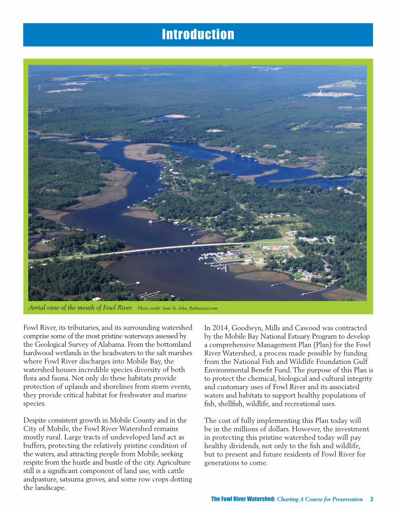
Fowl River, its tributaries, and its surrounding watershed comprise some of the most pristine waterways assessed by the Geological Survey of Alabama. From the bottomland hardwood wetlands in the headwaters to the salt marshes where Fowl River discharges into Mobile Bay, the watershed houses incredible species diversity of both flora and fauna. Not only do these habitats provide protection of uplands and shorelines from storm events, they provide critical habitat for freshwater and marine species.
Despite consistent growth in Mobile County and in the City of Mobile, the Fowl River Watershed remains mostly rural. Large tracts of undeveloped land act as buffers, protecting the relatively pristine condition of the waters, and attracting people from Mobile, seeking respite from the hustle and bustle of the city. Agriculture still is a significant component of land use, with cattle andpasture, satsuma groves, and some row crops dotting the landscape.
Aerial view of the mouth of Fowl River. Photo credit: Sam St. John, flythecoast.com
In 2014, Goodwyn, Mills and Cawood was contracted by the Mobile Bay National Estuary Program to develop a comprehensive Management Plan (Plan) for the Fowl River Watershed, a process made possible by funding from the National Fish and Wildlife Foundation Gulf Environmental Benefit Fund. The purpose of this Plan is to protect the chemical, biological and cultural integrity and customary uses of Fowl River and its associated waters and habitats to support healthy populations of fish, shellfish, wildlife, and recreational uses.
The cost of fully implementing this Plan today will be in the millions of dollars. However, the investment in protecting this pristine watershed today will pay healthy dividends, not only to the fish and wildlife, but to present and future residents of Fowl River for generations to come.
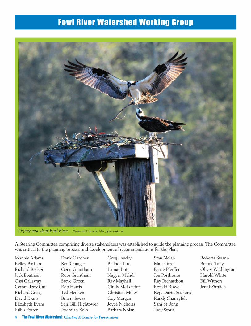
Osprey nest along Fowl River. Photo credit: Sam St. John, flythecoast.com
4 The Fowl River Watershed: Charting A Course for Preservation
Johnnie AdamsKelley BarfootRichard BeckerJack BoatmanCasi CallawayComm. Jerry CarlRichard CraigDavid EvansElizabeth EvansJulius Foster
Frank GardnerKen GrangerGene GranthamRose GranthamSteve GreenRob HarrisTed HenkenBrian HewesSen. Bill HightowerJeremiah Kolb
Greg LandryBelinda LottLamar LottNayyer MahdiRay MayhallCindy McLendonChristian MillerCoy MorganJoyce NicholasBarbara Nolan
Stan Nolan Matt OrrellBruce PfeifferJon PorthouseRay RichardsonRonald RowellRep. David SessionsRandy ShaneyfeltSam St. JohnJudy Stout
Roberta SwannBonnie TullyOliver WashingtonHarold WhiteBill Withers Jenni Zimlich
Fowl River Watershed Working Group
A Steering Committee comprising diverse stakeholders was established to guide the planning process. The Committee was critical to the planning process and development of recommendations for the Plan.

Fowl River 1938. Photo credit: Kane Family
Fowl River 1938. Photo credit: Kane Family
The Fowl River Watershed: Charting A Course for Preservation 5
Watershed History
The Mobile Bay area has a rich history and cultural heritage that precedes the first recorded European exploration during the 16th century. The word “Mobile” is believed to have been derived from a Choctaw word for “paddlers.” Sometime around 1698, Jean Baptiste Lemoyne de Bienville and his brother, Pierre Le Moyne d’Iberville, came to Mobile and began to explore the surrounding landscape. The brothers discovered a freshwater spring along the beaches of the western shore of Mobile Bay and named it Belle Fontaine. They moved French colonists from Louisiana to settle the area and establish a deep-water port on Dauphin Island. It was these early French colonists, describing a land of bountiful wildlife and shores teeming with waterfowl, who named the main river in this region “Riviere aux Poules” or Fowl River.
Not surprisingly, one of the oldest industries in the area is shipbuilding. The shipyard on Mon Luis (or alternately Mon Louis) Island, at the mouth of Fowl River, was founded in the 1850s. Workers built boats from cypress trees harvested from the surrounding wetlands. They also built the ships used by the Confederate Navy to “run” the Union blockade at the mouth of Mobile Bay. Although the shipyard closed in 1954 after operating for nearly a century, the tradition continues in boatyards located along Bellingrath Road just south of Theodore.

6 The Fowl River Watershed: Charting A Course for Preservation
From its origin, or headwaters, near Goldmine and Three Notch Roads in south central Mobile County, Fowl River flows south and east for nine miles to where it splits to form East Fowl River and West Fowl River. East Fowl River flows northeast directly into Mobile Bay, and West Fowl River flows south into Mississippi Sound. The Watershed encompasses 52,782 acres (or 82 mi²).
The gentle topography of the Fowl River Watershed produces a fall of less than 150 feet from the river’s headwaters to Mobile Bay, with the majority of that relief occurring in the upper third of the Watershed. Tributary drainages in the upper reaches of the Watershed, where greater relief is present, are well- defined but become more nebulous as they meander across coastal lowlands to East Fowl River.
As a result of the flat topography, the Watershed has only two distinct tributaries: Muddy Creek and Dykes
Creek, both located in the central portion of the Watershed. The former begins east of Bellingrath Road, about two miles north of Laurendine Road, and travels about 4.5 miles to its terminus with Fowl River. The latter originates less than a mile east of Muddy Creek and about two miles north of Fowl River Road and flows about 2.5 miles to its confluence with Fowl River. The gentle topography and abundant rainfall create extensive floodplains and wetland areas, not only along these tributaries, but throughout the Watershed and along the main branch of Fowl River.
In 2015, a population of 19,842 lived in the Watershed, with the majority concentrated around US Highway 90 and Interstate 10 in the upper half of the Watershed. By 2030, overall watershed population is projected to be 20,985, an 8.4% increase, while overall urban land use is expected to nearly double from 13.7% to 24.9%.
Watershed Characteristics
Aerial view of Fowl River spit “Tapia.” Photo credit: Sam St. John, flythecoast.com

Fowl River Land Usage 1996-2008
The Fowl River Watershed: Charting A Course for Preservation 7
Land Use 2011 2030Upland Forest 20.6% 17.9%
Upland Herbaceous 34% 27%
Woody Wetlands 27.1% 26%
As of 2011, 81% of land use in the Watershed included upland forest, upland herbaceous, and woody wetlands, providing further evidence that much of the Watershed remains sparsely developed. By 2030, land use estimates project only minor decreases in woody wetlands and upland forest, with upland herbaceous decreasing the most. The projected decrease in upland herbaceous (agriculture/pasture) likely represents a transition of these lands to urban to meet anticipated growth.
Impervious cover; including roads, parking lots, sidewalks, rooftops and other impermeable surfaces; of the Fowl River Watershed was 2.76% (1,000 acres) in 2015, indicating healthy, intact ecosystems. Impervious cover exceeding 10% triggers negative water quality and stream channel impacts typically associated with land development. Increases in impervious cover contribute to increases in the volume and velocity of stormwater, greater amounts of pollutants in the runoff, and loss of both terrestrial and aquatic habitats. To compare, the Three Mile Creek Watershed, located mostly within Mobile city limits, has greater than 37% impervious cover, and the D’Olive Creek Watershed in Baldwin County has between 20-25%. In Fowl River the highest percentages of impervious cover are found where most development has occurred (I-10, US 90, Tillman’s Corner, and Theodore). Even these more developed areas fall well under the 10% threshold.

Fowl River Land Usage 2011-2030
8 The Fowl River Watershed: Charting A Course for Preservation
The relative good health of the Fowl River Watershed is in large part due to the existence of wetlands. Wetlands contribute to the vitality of an ecosystem by storing, filtering and cleaning, and transmitting surface water and groundwater. Through this process pollution is filtered, nutrients are recycled, groundwater is recharged, and biodiversity is enhanced through provision of habitats for a wide variety of fish, wildlife, and plants. Wetland composition varies extensively; thus five distinct categories are used for classification: estuarine, lacustrine, marine, palustrine, and riverine systems (Cowardin, 1979). The two major wetland classification types located within the Fowl River Watershed are palustrine (nontidal) and estuarine (tidal).
From the bottomland hardwood wetlands in the headwaters to the salt marshes where Fowl River discharges into Mobile Bay, there is incredible species diversity of both flora and fauna within the Watershed. Not only do these habitats provide storm event/ shoreline protection and nutrient removal, they provide critical habitat for freshwater and marine species. Fish documented in Fowl River included bluegill sunfish (Lepomis macrochirus), pinfish (Lagodon rhomboides), striped mullet (Mugil cephalus), red drum (Sciaenops ocellatus), spotted sunfish (Lepomis punctatus), menhaden (Brevoortia tyrannus), warmouth (Lepomis gulosus), largemouth bass (Micropterus salmoides), orange-spotted sunfish (Lepomis humilis), Atlantic croaker (Micropogaonias undulatus), spotted seatrout (Cynoscion nebulosus), and flounder (Paralichthys spp).

The Fowl River Watershed: Charting A Course for Preservation 9
Critical Issues in the Watershed
Fowl River carries the Alabama Department of Environmental Management’s (ADEM) water use classification of Swimming and Other Whole Body Contact Water Sports and Fish and Wildlife along its entire course (ADEM, 2006). Likewise, East Fowl River carries the water use classification of Swimming and Other Whole Body Contact Water Sports and Fish and Wildlife along its entire course. Muddy Creek and Dykes Creek are not specifically listed within Division 6 of the ADEM’s Administrative Code and, therefore, carry a water use classification of Fish and Wildlife (ADEM, 2006).
Although the Plan characterizes the overall health of the Watershed to be in good condition, several issues impacting ecosystem health necessitate further monitoring and corrective actions:
Mercury Impairments – Fowl River is listed on the State of Alabama’s 303(d) list of impaired waters for its mercury concentrations. The source of the mercury found in fish appears to be atmospheric deposition. Thus, there is no local corrective action that can be
performed within the Watershed. In 2002, the State Health Department issued a fish consumption advisory warning people not to consume largemouth bass from Fowl River, which remains in effect as of 2017.
Sediment Transport – In 2015, the Geological Survey of Alabama completed the report, Pre-Restoration Analysis of Discharge, Sediment Transport Rates, and Water Quality in tributaries of Fowl River, Mobile County, Alabama to support the development of the Plan. Data collected for this report provides the most current and thorough assessment of water quality conditions in the freshwater segments of Fowl River. With regard to total sediment loads, results from the GSA study indicate that Fowl River ranks among the lowest of any monitored watershed in the State of Alabama. The chart below shows total normalized sediment load (tons/mi2/year) for nine Fowl River Watershed sites versus results from other Mobile Bay sub-watersheds.
Fowl River Mobile and Baldwin Counties Stream Comparison
*UT = Unnamed Tributary Monitored site name and number
Graph from Cook, Moss, and Rogers, 2015.

Nutrient Loading – The Geological Survey Report identified nutrient loading as a potential future concern, documenting nitrate loading exceeding the critical concentration of 0.5 mg/L associated with excessive algal growth. This was attributed to both nonpoint sources (cumulative loading from a large sub-basin) and point sources (greenhouse nurseries, row cropping, and areas of harvested timber). Phosphate and total organic carbon loading were attributed to point sources (plant nursery operations and row cropping). Excessive nitrogen and phosphorous loading could have negative impacts on water quality within the estuarine waters of Fowl River. Additional pollutant load modeling identified urbanized and agricultural areas within the Watershed as primary sources of nutrients.
Stormwater Runoff – Incidences of large-volume stormwater flows result from altered hydrology, intense rainfall events, and impervious cover resulting from urban development. The loss of wetlands, the channelization of streams, and insufficient employment of riparian buffers has transformed the natural hydrologic regime of the Watershed. The impacts include increased runoff, stormwater flows, and flooding negatively affecting the water quality of the Watershed. As the Watershed is further developed, stormwater runoff will become a greater concern, as urbanized land and impervious cover increase stormwater runoff.
Invasive Species – Invasive species are plants or animals that have been introduced to an area outside of their original range. Typically, these species spread incredibly fast, due to their rapid reproduction rates and abilities to outcompete native species for resources. In many cases, the ecological integrity and biodiversity of an area is threatened when homogeneous stands of invasive species are established. Throughout the field reconnaissance conducted by the Watershed Management Team, four plant species were predominately noted as species of
significant concern: Cogongrass (Imperata cylindrical), Chinese Privet (Ligustrum sinense), Chinese Tallow/ Popcorn tree (Triadica sebifera), Common reed (Phragmites australis), although a native species, is also frequently considered a nuisance species due to its ferocity to reproduce rapidly and suppress native plant diversity.
Habitat Loss – Loss of habitat within the Watershed was identified utilizing historic photographs, maps, land-use coverage data, and computer modeling. The greatest loss of historic habitat has occurred as a result of draining wetlands for row cropping, ranching, and development. Additional habitat loss has occurred in the coastal zone of Fowl River as a result of erosion caused by high flow events, boat wakes, and sea level rise. The islands, spits, marshes, and shorelines in the lower portions of the Watershed, where waters transition from fresh to brackish, have been especially hard hit. Because of the importance of wetlands, shorelines, and marshes to water quality and as aquatic nursery areas, loss of habitat is a critical issue that must be addressed.
Cogongrass (Imperata cylindrical) Photo credit: Alabama Forestry Committee
10 The Fowl River Watershed: Charting A Course for Preservation
Key takeaways from the Pre-Restoration Fowl River Sediment study indicate that:
➤ The predominantly rural setting, extensive wetlands and forests, and use of winter cover crops on agricultural fields limits the sediment loads in Fowl River and helps maintain very good water quality overall;
➤The largest sediment loads observed occurred in basins with the largest percentages of agricultural land use;
➤Concentrations of heavy metals in sediments increased from upstream to downstream, and their occurrence is attributed to pervasive anthropogenic (human-derived) sources; and
➤To preserve the health of the Fowl River ecosystem, the report recommends use of best management practices that preserve wetlands, prevent erosion and sediment transport from timbered and row crop areas, and control runoff from construction sites and impervious surfaces.

The Fowl River Watershed: Charting A Course for Preservation 11
Chinese Privet (Ligustrum sinense)
Chinese Tallow/Popcorn tree (Triadica sebifera)
Common reed (Phragmites australis) Photo credit: Graves Lovell
To address chronic habitat loss on the northern tip of Mon Louis Island, in November 2013, the National Fish and Wildlife Foundation’s Gulf Environmental Benefit Fund awarded the MBNEP over $3.24 Million to restore this frontline land mass at the mouth of Fowl River, and to undertake a sediment-loading analysis and develop the Fowl River Plan. Today, the Plan is complete, Sen. Hightower secured funds to dredge the shallow and neglected Fowl River navigation channel, and contractors have completed the final earthwork on the four acres of restored Mon Louis Island salt marsh.
Land Use Change – Converting natural landscapes to developed areas can trigger or exacerbate Plan-identified stressors. A watershed, like most complex natural systems residing in a natural state, evolves to a level of equilibrium, where under normal conditions it is healthy and able to adapt to changes over time, cope with periods of stress (i.e. hurricanes, flooding, drought, fire, etc.), and rebound when normal conditions return. Humans represent the “wild card” to natural systems because of our ability to significantly alter landscapes and natural ecosystem functions. Dredging and filling, habitat fragmentation, and sedimentation are all anthropogenic (man-made) practices related to land-use change. However, these influences to some degree are unavoidable when factoring population growth and societal demands for 21st century amenities over the next 25 years. As Fowl River is, at present, a generally healthy watershed, future efforts of conservation coupled with restoration will be necessary to buffer any land conversion impacts.
Currently, the watershed lacks sufficient zoning regulations prescribing how, where, and when an area will be developed, making it difficult to predict actual impacts of future land use on watershed health. The Plan recommends updating standards regulating development, impervious cover, and utilization of green infrastructure and Low Impact Development (LID) techniques.
12 The Fowl River Watershed: Charting A Course for Preservation
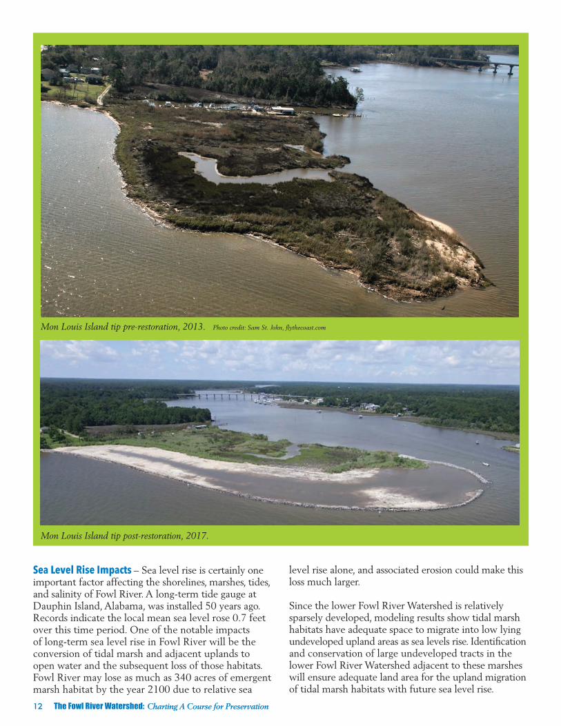
Mon Louis Island tip pre-restoration, 2013. Photo credit: Sam St. John, flythecoast.com
Mon Louis Island tip post-restoration, 2017.
Sea Level Rise Impacts – Sea level rise is certainly one important factor affecting the shorelines, marshes, tides, and salinity of Fowl River. A long-term tide gauge at Dauphin Island, Alabama, was installed 50 years ago. Records indicate the local mean sea level rose 0.7 feet over this time period. One of the notable impacts of long-term sea level rise in Fowl River will be the conversion of tidal marsh and adjacent uplands to open water and the subsequent loss of those habitats. Fowl River may lose as much as 340 acres of emergent marsh habitat by the year 2100 due to relative sea
level rise alone, and associated erosion could make this loss much larger.
Since the lower Fowl River Watershed is relatively sparsely developed, modeling results show tidal marsh habitats have adequate space to migrate into low lying undeveloped upland areas as sea levels rise. Identification and conservation of large undeveloped tracts in the lower Fowl River Watershed adjacent to these marshes will ensure adequate land area for the upland migration of tidal marsh habitats with future sea level rise.

The Fowl River Watershed: Charting A Course for Preservation 13
Watershed Management Goals & Objectives
GOAL: Improve habitats necessary to support healthy populations of fish, shellfish, wildlife, and community resilience.
Objectives:
➤ Develop a habitat conservation program to provide for upland migration of tidal marshes, protection of riparian buffers, and freshwater wetlands.
➤ Restore/enhance 500 acres of freshwater wetlands.
➤ Restore 13,500 linear feet of stream/riparian buffer.
➤ Stabilize 22,000 linear feet of shoreline.
➤ Protect/enhance 35 acres of salt marsh.
GOAL: Maintain water quality to support healthy populations of fish, shellfish, wildlife, and traditional uses.
Objectives:
➤ Pursue new ADEM water use category to establish Fowl River as an “Outstanding Coastal Water.”
➤ Work with Natural Resources Conservation Service (NRCS) to install agricultural best management practices.
➤ Modify county and city subdivision regulations to require improved stormwater management.
➤ Develop a comprehensive watershed education program for county and municipal staffs.
➤ Reduce litter along roadsides by 75%.
➤ Create one recycling drop off location.
➤ Create and sustain 10 volunteer water quality monitoring sites.
➤ Promote participation in the Create a Clean Water Future campaign.
GOAL: Expand opportunities for community stewardship of and access to open spaces and waters of the Watershed.
Objectives:
➤ Create one public access point.
➤ Develop a boater education program addressing critical issues and impacts associated with recreation activities, including but not limited to boat wakes, sensitive habitats, and underwater hazards.
The Plan provides an implementation strategy focused on three overarching goals: 1) Improve habitats necessary to support healthy populations of fish, shellfish, wildlife, and community resilience; 2) maintain water quality to support healthy populations of fish, shellfish, wildlife, and traditional uses; and 3) expand opportunities for community stewardship of and access to open spaces and waters of the Watershed.

14 The Fowl River Watershed: Charting A Course for Preservation
Cost Estimates and Financing OptionsThe costs of implementing the 38 projects identified in the Plan is estimated to range between $30 million and $33 million and includes, but is not limited to, stabilizing coastal shorelines, restoration of headwater streams, and retrofitting stormwater infrastructure. Successful implementation of the management measures recommended in this Plan will require the long-term commitment of significant financial resources and community support.
The design, construction, and maintenance of stormwater improvements; purchase of land for offline storage; modification and/or protection of shorelines to reduce erosion; or the purchase and preservation of tracts of land to create greenspace buffers, wetlands, or floodplains to protect stream quality will require significant and reliable funding. Because the jurisdictional areas of political entities that might provide funding do not follow or encompass Watershed boundaries, a public- private partnership may be the most effective way to accomplish management goals.
Alternatives for funding and financing improvements in the Fowl River Watershed include: ➤ Water use service fees (i.e., stormwater utility fees)
➤ Federal grants, loans, and revenue sharing
➤ Non-governmental organizations/other private funding
➤ Mitigation banks
➤ Environmental tax shifting
➤ Regional collaborative opportunities
➤ RESTORE/National Fish and Wildlife Foundation Gulf Coast Environmental Benefit Fund
➤ Natural Resources Conservation Service Agricultural Conservation Easement Program and Healthy Forest Reserve Program
➤ Gulf of Mexico Energy Security Act
Bald eagles along Fowl River. Photo credit: Sam St. John, flythecoast.com

The Fowl River Watershed: Charting A Course for Preservation 15
Outreach and Education
The outreach program should include:
➤ Concerted efforts to emphasize the importance of water quality and create watershed resident interest to participate in volunteer monitoring and cleanup activities;
➤Signage posted on major thoroughfares to inform drivers that they are entering the Fowl River Watershed;
➤ Informational signage at boat landings and public access points to encourage the public to help preserve and protect Fowl River through good stewardship; and
➤Trash containers and/or dumpsters with appropriate signage co-located at public access points and other strategic locations as a reminder to keep the Watershed clean and free of trash.
Above, volunteers attend a Water Quality Monitoring training class. Below, Fowl River Plan meeting.
Volunteers at Coastal Cleanup help to clean up the waterway.
Management of any natural resource is enhanced by understanding, support, and participation of the stakeholders. Successful implementation of the recommended management measures may not be possible without public education and outreach, which is also one of the EPA’s nine key elements for watershed planning. A consistent and targeted education and outreach program will raise public awareness and support for the recommended management measures necessary to protect and improve the health of the Watershed.

First StepsDespite some challenges often associated with lands transitioning from rural to urban uses and the impacts from increased habitat loss and stormwater flows, the Fowl River Watershed is remarkably pristine. Stakeholders have an opportunity successfully implement the measures recommended in the Plan by taking these first steps: Establish a Watershed Management Task Force (WMTF). The WMTF should immediately seek funding, assess the current regulatory framework, and work with the Mobile County officials to include all best management practices and LID strategies for new development regulations.
1. Install watershed signage to increase public awareness of their connection to Fowl River.
2. Advocate for the updating of subdivision regulations and encourage retrofitting of existing developments to meet best management practices and LID standards.
3. Implement projects to stabilize and protect spits in the coastal zone. Study wetland function and hydrologic flow from the headwaters to the estuary.
4. Advocate for improved household waste management through trash management via drop off and collection centers and enforcement of illegal dumping laws.
5. Emphasize a public outreach, education, and community involvement program including establishment of a Volunteer Water Quality Monitoring program, a boater education program, a municipal and county staff training curriculum, and increased participation in the Create a Clean Water Future campaign.
6. Pursue partnerships to leverage multiple funding sources to address wetland and stream restoration projects and stormwater management projects in the upper Watershed with willing landowners.
Wood Duck. Photo credit: Sam St. John, flythecoast.com Osprey in nest. Photo credit: Sam St. John, flythecoast.com
To learn more about the Mobile Bay National Estuary Program or the Fowl River Watershed Management Plan, visit www.mobilebaynep.com.