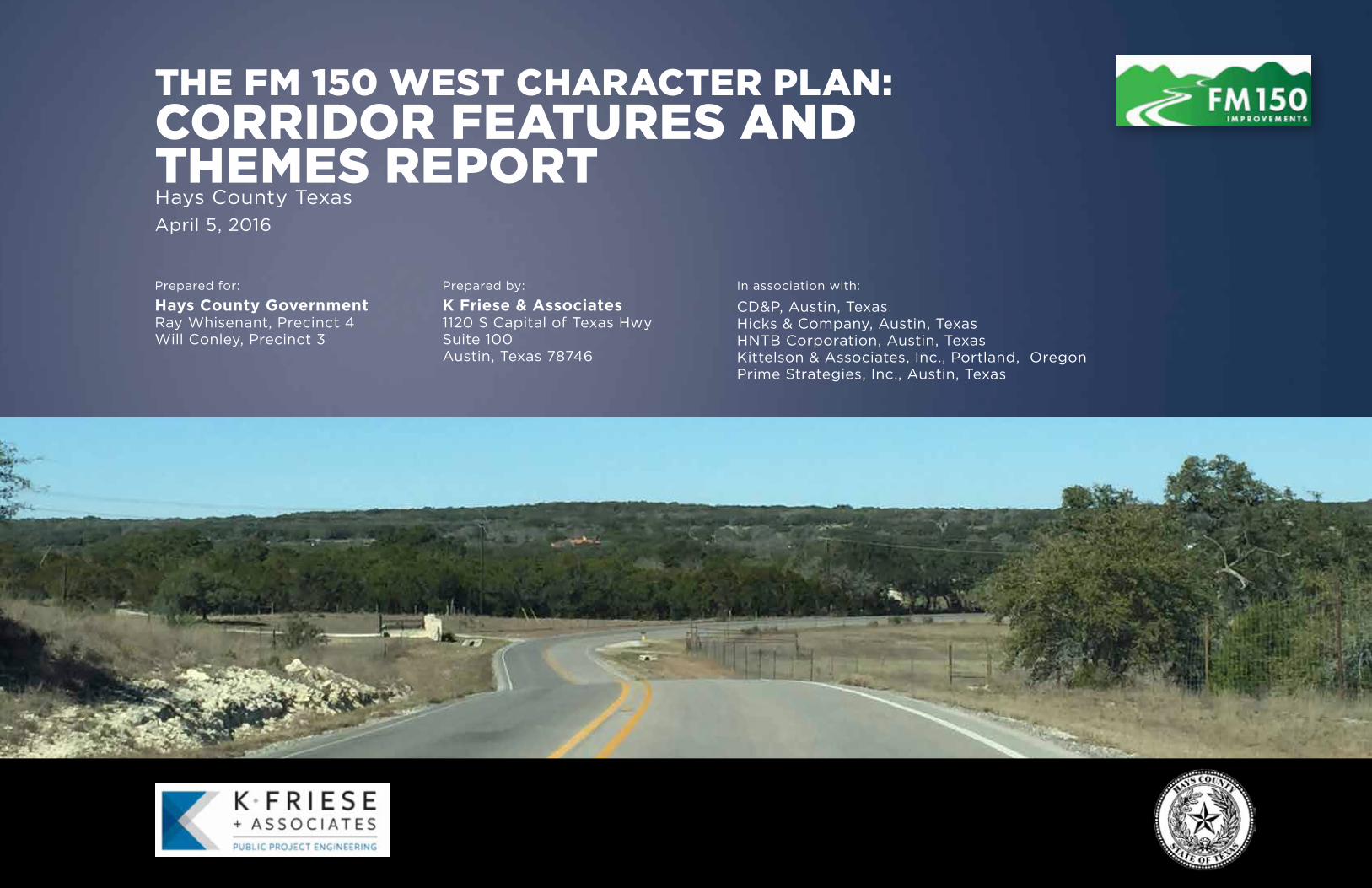
The fm 150 wesT characTer plan: corridor feaTures and ...
84
THE FM 150 WEST CHARACTER PLAN: CORRIDOR FEATURES AND THEMES REPORT Hays County Texas April 5, 2016 Prepared for: Hays County Government Ray Whisenant, Precinct 4 Will Conley, Precinct 3 Prepared by: K Friese & Associates 1120 S Capital of Texas Hwy Suite 100 Austin, Texas 78746 In association with: CD&P, Austin, Texas Hicks & Company, Austin, Texas HNTB Corporation, Austin, Texas Kittelson & Associates, Inc., Portland, Oregon Prime Strategies, Inc., Austin, Texas
Transcript of The fm 150 wesT characTer plan: corridor feaTures and ...
The fm 150 wesT characTer plan: corridor feaTures and Themes reporTHays County TexasApril 5, 2016
Prepared for:
Hays County Government Ray Whisenant, Precinct 4Will Conley, Precinct 3
Prepared by:
K Friese & Associates1120 S Capital of Texas HwySuite 100Austin, Texas 78746
In association with:
CD&P, Austin, TexasHicks & Company, Austin, TexasHNTB Corporation, Austin, TexasKittelson & Associates, Inc., Portland, OregonPrime Strategies, Inc., Austin, Texas

Acknowledgement and Contents
2
(back of cover)

Acknowledgement and Contents
3
COMMISSIONERS
Commissioner Will Conley, Hays County Precinct 3
Commissioner Ray Whisenant, Hays County Precinct 4
CITIZEN ADVISORY PANEL
David Braun
Casey Cutler
Dennis Dement
Shelby Eckohls
Sharon Michaelis
Mark Oechsner
Roger Pruitt
Maile Roberts
Judge Bob Shannon
Mike Steinert
Bruce Turbow
FM 150 WEST CHARACTER PLAN STUDY TEAM
K Friese & Associates, Inc. (KFA)
Greg Blackburn
Joseph Cantalupo
Dan Cryan
Joseph Skidmore
--- with ---
Concept Development & Planning, LLC (CD&P)
Albert Castro
Arin Gray
Julie Richey
Hicks & Company
John Kuhl
Julie LeClair
Kittelson & Associates, Inc. (KAI)
Kelly Laustsen
Brian Ray
FOR HAYS COUNTY
HNTB Corporation
Laura Harris
Stephanie Russell
Prime Strategies, Inc.
Paula Gruber
Mike Weaver
Public Meeting #2
Citizens Advisory Panel Meeting #6A
ACKNOWLEDGEMENTS
The Hays County Commissioners Court, the Citizens Advisory Panel, and the Study Team wish to thank The Salt Lick and the Driftwood Community Center for their generous donation of space and services throughout the study process.

Page left intentionally blank
Acknowledgement and Contents
5
This report documents the unique and proactive approach the Hays
County Commissioners Court has taken to ultimately develop a long-
range master plan for establishing the future form and function of FM
150. When completed, the master plan, which is also called the FM 150
West Character Plan, will serve as the “blueprint” from which future FM
150 corridor projects are developed. A long-range master plan approach
will result in an FM 150 roadway facility that will serve forecasted
growth while protecting the unique history, heritage, rural, and natural
character of this portion of Hays County. This Corridor Features and
Themes Report documents the process used to define the nature and
character of roadway elements that are to be preserved and protected,
to the extent possible, while considering long range FM 150 corridor
improvements. A master plan approach, via the FM 150 West Character
Plan, is the means of integrating the unique natural and developed
features along the FM 150 corridor between Dripping Springs and Kyle
through the years – well outside the typical timeline of constructing
projects. This Character Plan will set foundation for future County
Commissioners, project stakeholders, and the community.
The approach for this Character Plan is considered unique and proactive
because both stakeholders and the public were heavily engaged early in
the planning process. This is not a traditional study approach where
plans are quickly established to facilitate immediate impending
construction. These FM 150 corridor evaluations are occurring long
before roadway congestion or public safety needs are acute. The study
efforts described in this document are in advance of when traditional
environmental documentation typically occurs. This proactive approach
means the community has time to engage in a meaningful way without
agency teams being rushed to meet imposed deadlines, or otherwise
truncate the stakeholder outreach efforts.
A first step in developing the Character Plan has been documenting the
corridor’s features and themes, which will be used to guide future
planning activities. This report describes this work, which has been
driven and guided by extensive community outreach. This outreach has
been characterized by the strong passion and ownership of those who
serve in County-appointed roles on the Citizens Advisory Panel (CAP),
and demonstrated commitment and participation by local property
owners and the community at large. These community partners have
devoted an unprecedented amount of time to articulate and share key
qualities and characteristics of the area. The features and themes they
have identified form the foundation upon which the technical
transportation corridor planning will be completed. The local
community has helped define timelines of early and subsequent
settlements, shared information about caves and other natural
features, and revealed special places that represent connections to their
family roots that may otherwise have been lost. It is this information
that has helped the technical team understand critical corridor
elements to be documented and protected when developing a plan to
meet impending long term growth and associated transportation
demand.
Hays County is developing and integrating new and emerging methods
and technical approaches to ensure future corridor concepts are
developed in flexible ways. Flexibility in highway design and
performance-based approaches allow the range of solutions to be
adaptive and better integrated into the natural and developed
environment. Historical highway design has used a brute force method
to cut, fill, and straighten roadway alignments. Wider is not always
better. Straighter is not always safer. Adding roadway capacity does not
mean the traffic must go faster. FM 150 is a continuous corridor from
Dripping Springs to Kyle however; the corridor itself is a composite of
unique and special character zones. Employing performance-based
approaches means an ultimate master plan for FM 150 can be
integrated into the surrounding landscape and consider the discrete and
unique contexts along the entire corridor.
This is the first step in a series of incremental corridor development
activities. Future stages will include:
delving in deeper to further ensure specific corridor needs
commensurate with the study context;
integrate project stakeholders and the community at large as more
refined solutions are developed and prioritized;
refined solutions will integrate the nature and character of the
corridor’s physical form into the surrounding landscape; and
as needs are better defined and prioritized, they will be
documented in a master plan (the Character Plan) that defines the
corridor improvement plan over time.
The activities documented have led to a continuum of project
improvements to enhance the safety, performance, and reliability of the
corridor. Many of the initial activities could be programmed with
routine pavement and roadway maintenance and management
activities. These initial actions would be relatively low impact and occur
within the corridor right of way. Initial study elements could be safety
focused, such as widening shoulders and improving or creating clear
areas next to the roadway. Isolated intersection designs could include
elements that make the intersection presence more pronounced and
visually apparent so drivers can react and adapt to the increased
conflicts at public roads or driveways.
In future steps for FM 150-specific needs and for other non-FM 150
projects that may result, Hays County is committed to a transparent
process that continuously and meaningfully engages and integrates
community ownership, commitment, and passion. More significant
corridor treatments will include proactive and collaborative planning
processes, tailored to each project need. This Corridor Features and
Themes Report sets the tone for future work on FM 150.
PREFACE

Page left intentionally blank
Acknowledgement and Contents
7
1 OVERVIEW AND PURPOSE ........................................ 3
1.1 BACKGROUND ....................................................................... 3
1.2 PURPOSE OF REPORT............................................................. 6
1.3 NEXT STEPS ............................................................................ 6
2 STUDY GOALS ........................................................... 9
3 PUBLIC INVOLVEMENT ........................................... 13
3.1 CITIZEN ADVISORY PANEL ACTIVITIES ................................. 13
3.2 PUBLIC MEETINGS ............................................................... 14
3.3 ADDITIONAL MEETINGS....................................................... 16
4 CORRIDOR OPPORTUNITIES AND CONSTRAINTS .... 21
4.1 EXISTING LAND USES ........................................................... 21
4.2 KEY FEATURES AND POINTS OF INTEREST ........................... 21
4.3 CULTURAL AND ENVIRONMENTAL RESOURCES .................. 21
4.4 CORRIDOR CONTEXT ZONES ................................................ 27
5 EXISTING CONDITIONS ........................................... 33
5.1 INTERSECTION VOLUMES AND OPERATIONS ...................... 33
5.2 ROADWAY VOLUMES .......................................................... 33
5.3 CRASH HISTORY ................................................................... 35
5.4 CORRIDOR SPEEDS ............................................................... 41
5.5 EXISTING CROSS SECTION .................................................... 43
6 FUTURE PLANNING FRAMEWORK .......................... 47
6.1 CONTEXT SENSITIVE SOLUTIONS APPROACH ...................... 47
6.2 FEATURES AND THEMES ...................................................... 48
6.3 FORECAST TRAFFIC .............................................................. 51
7 CONTINUUM OF IMPROVEMENTS ......................... 55
7.1 FUTURE ALIGNMENT AND CONCEPTS ................................. 55
8 NEXT STEPS ............................................................ 69
9 REFERENCES ........................................................... 73
VOLUME 2 (TECHNICAL APPENDICES)
SECTION 1: Land Use Figures
SECTION 2: List of Land Uses
SECTION 3: Potential Environmental and Cultural Constraints Figures
SECTION 4: List of Vegetation
SECTION 5: Intersection Turning Movement Counts and Operations
SECTION 6: Roadway Tube Counts
SECTION 7: Crash Data
VOLUME 3 (PUBLIC MEETING REPORTS)
SECTION 1: October 2014 Meeting Report
SECTION 2: March 2015 Meeting Report
SECTION 3: October 2015 Meeting Report
TABLE OF CONTENTS

Page left intentionally blank

Acknowledgement and Contents
9
Exhibit 1. Hays County Transportation Plan Major Thoroughfares………… 3
Exhibit 2. Study Area…………………………………………………………………………….. 4
Exhibit 3. Project Schedule…………………………………………………………………… 5
Exhibit 4. Low Water Crossing on FM 150…………………………………………….. 9
Exhibit 5. Michaelis Ranch……………………………………………………………………. 9
Exhibit 6. CAP Meeting #6 – August 2015…………………………………………….. 13
Exhibit 7. CAP Meeting #6 – August 2015……………………………………………… 13
Table 1: CAP Meeting Summary……………………………………………………………. 14
Exhibit 8: Public Meeting #2 – March 2015………………………………………….. 14
Exhibit 9: Map Comments from Public Meeting #2………………………………. 15
Exhibit 10: Public Meeting #2 Comments – Related Area……………………… 15
Exhibit 11: Public Meeting #2 Comments – Theme………………………………. 15
Exhibit 13: Comments - Reoccurring Topics………………………………………….. 16
Exhibit 12: Public Meeting #3 – October 2015……………………………………….16
Table 2: FM 150 West Character Plan Stakeholder Meetings……………….. 17
Exhibit 14: Land Use Study Area…………………………………………………………… 22
Exhibit 15: Potential Environmental and Cultural Restraints…………………. 24
Exhibit 16. Corridor Context Zones……………………………………………………….. 27
Exhibit 17. Driftwood……………………………………………………………………………. 28
Exhibit 18. FM 150 Traveling Westbound……………………………………………… 28
Exhibit 19. Low Water Crossing…………………………………………………………… 28
Exhibit 20. Michaelis Ranch………………………………………………………………….. 29
Exhibit 21. Approach to Driftwood from the East…………………………………. 29
Exhibit 22 Approach to Darden Hill Road from the East……………………….. 29
Exhibit 23. Corridor Peak Hour Volume Patterns………………………………….. 33
Table 3. Average Weekday Daily Volumes by Direction………………………… 33
Exhibit 24. Tube Count Volumes…………………………………………………………… 34
Exhibit 25. Fatal Crash Locations (January 2010 – June 2014) ……………… 35
Exhibit 26. Crashes by Type versus Severity…………………………………………. 36
Exhibit 27. Crashes by Location versus Severity……………………………………. 36
Exhibit 28a. Crash Type (a) …………………………………………………………………… 37
Exhibit 28b. Crash Type (b) ………………………………………………………………….. 38
Exhibit 29a. Crash Severity (a) ……………………………………………………………… 39
Exhibit 29b. Crash Severity (b) ……………………………………………………………… 40
Exhibit 30. InformationalGuide…………………………………………………………… 41
Exhibit 31. Application Design Speed versus Speed Consistency
Methodologies………………...……………………………………………………….….. 41
Exhibit 32. Horizontal Curve Inferred Speed on Corridor……………………… 42
Exhibit 33. Horizontal curve with a posted (advisory) speed of 45 miles
per hour and inferred speed 52 miles per hour……………………….……. 42
Exhibit 34. Diagram of Existing Cross Section……………………………………….. 43
Exhibit 35. Examples of Cross Section along FM 150 corridor………………. 43
Exhibit 36. Project Develop Process and Associated Activities……………… 47
Exhibit 37. Example Application of Context Sensitive Solutions ………….. 48
Exhibit 38. Population and Employment Projections……………………………. 51
Exhibit 39. Change in Population (left) and Employment (right)
Density 2010 to 2040………………………..…………………………………………… 52
Exhibit 40. Project Timeline…………………………………………………….……………. 55
Exhibit 41. Near-, Mid-, and Long-Term Improvements………………………… 55
Exhibit 42. Safety Section Cross-Section……………………………………………….. 56
Exhibit 43. Safety Section Example from RM 12……………………………………. 56
Exhibit 44. Example Curve Treatment Applications………………………………. 57
Exhibit 45. Potential Future Capacity on Corridor…………………………………. 58
Exhibit 46. South Section (from Arroyo Ranch to RM 3237) ………………… 59
Exhibit 47. Existing Roadway (traveling westbound on FM 150)…………… 59
Exhibit 48. Conceptual Improvements for South Section……………………… 59
Exhibit 49. FM 150 at RM 3237…………………………………………………………….. 60
Exhibit 50. Existing Roadway (westbound approach on FM 150) …………. 60
Exhibit 51. Conceptual Future Improvements………………………………………. 60
Exhibit 52. RM 3237 to Double Low Water Crossings………………………...... 61
Exhibit 53. Existing Roadway (traveling westbound on FM 150)…………… 61
Exhibit 54. Example of potential future cross section (Winter Mills
Parkway) ………………......…………………………......………………….…............. 61
Exhibit 55. FM 150 at the Double Low Water Crossings……………………….. 62
Exhibit 56. Existing Roadway (traveling westbound on FM 150)…………... 62
Exhibit 57. Conceptual Future Improvements……………………….................. 62
Exhibit 58. Driftwood Community Zone………………………........................... 63
Exhibit 59. Existing Roadway (traveling westbound on FM 150)…………… 63
Exhibit 60. Conceptual Future Improvements……………………….................. 63
Exhibit 61. North Section………………………......………………………....................64
Exhibit 62. Existing Roadway (traveling westbound on FM 150 at
Darden Hill)…..……………......………………………....................................... 64
Exhibit 63. Conceptual Future Improvements……………………….................. 64
Exhibit 64. Existing Roadway (traveling westbound on FM 150
at RM 12) .......................................................................................... 65
Exhibit 65. Conceptual Future Improvements.......................................... 65
Exhibit 66. Future Study Area................................................................... 66
Exhibit 67. Existing Roadway (traveling westbound towards Elder
Hill Road)…………………………………………………………………………………....….69
LIST OF EXHIBITS AND TABLES

Page left intentionally blank

SECTION 1 Overview and Purpose

Page left intentionally blank

Overview and Purpose
3
1 OVERVIEW AND PURPOSE
1.1 BACKGROUND
The FM 150 corridor runs from Ranch-to-Market Road (RM) 12 in
Dripping Springs, through Driftwood and Kyle, to State Highway (SH) 21
east of Interstate Highway 35 (I-35). FM 150 is under TxDOT jurisdiction
and ownership while being managed and maintained by Hays County
who serves as the steward of the facility.
The FM 150 West Character Plan study is focused on the west portion of
FM 150 between RM 12 in Dripping Springs and Arroyo Ranch Road at
the north end of Kyle, as shown in Exhibit 2. A separate and distinct
alignment study is focused on the portion from Arroyo Ranch Road
heading east near I-35. FM 150 is currently a two-lane roadway with
limited shoulders. The area surrounding the corridor is rural with
primarily low-density residential uses. There are a few areas of
commercial development and community centers, which are discussed
later in this report.
The character varies along the length of the corridor and contains
several community zones, such as the FM 150 and FM 3237
intersection, the town of Driftwood, and the FM 150 and RM 12
intersection. The corridor is valued for its natural beauty, cultural, and
historic features. The double low water crossings over Onion Creek are
a significant feature for area residents and preservation is a high priority
for the community. The corridor is also home to many historical
properties and features that hold significant importance to the families
that have lived along the corridor for many years, some for more than a
century.
The areas surrounding the corridor have grown significantly over the
past few decades and are projected to continue to grow and develop.
To plan for this growth while preserving the character of the FM 150
Corridor, Hays County has elected to take a proactive approach and
begin planning for the future now. This study of the western section of
FM 150 is the first step in a series of incremental corridor plan
development activities. The purpose of this study is to document the
FM 150 corridor nature and character and plan for potential future
improvements to enhance corridor operational and safety performance.
In the future, Hays County roads such as FM 150 are forecast to serve
increased travel demand. Specifically, FM 150 will need to
accommodate efficient travel between population and employment
centers. Population growth is primarily concentrated in San Marcos,
Kyle, and Buda and the County roads serving these areas are expected
to become more congested if no improvements are made ahead of
time.
2013 Hays County Transportation Plan
The 2013 Hays County Transportation
Plan (HCTP, Reference 1) was adopted in
January 2013 to update the County’s
previous 10-year old plan. Since the 2013
HCTP was adopted population and
employment projections have increased
beyond original projections. The HCTP
accounts for recent population growth
(around 60,000 people have moved to the
County since the last plan was adopted)
and considers future growth corridors.
Developing the HCTP included extensive
involvement of the community through
several public workshops and advisory
groups. The HCTP identifies current and
future transportation needs and seeks to
maintain and improve mobility and
accessibility throughout the County, as
seen in Exhibit 1. The HCTP includes a
major thoroughfare plan to preserve the
right-of-way needed for future transportation facilities. The HCTP
follows the County’s philosophy of focused improvements, which looks
to serve forecast travel demand by:
improving the safety and efficiency of roadways when opportunities
arise;
adding capacity to certain, key roadways; and,
adding new roadways only when needed.
Exhibit 1. Hays County Transportation Plan Major Thoroughfares
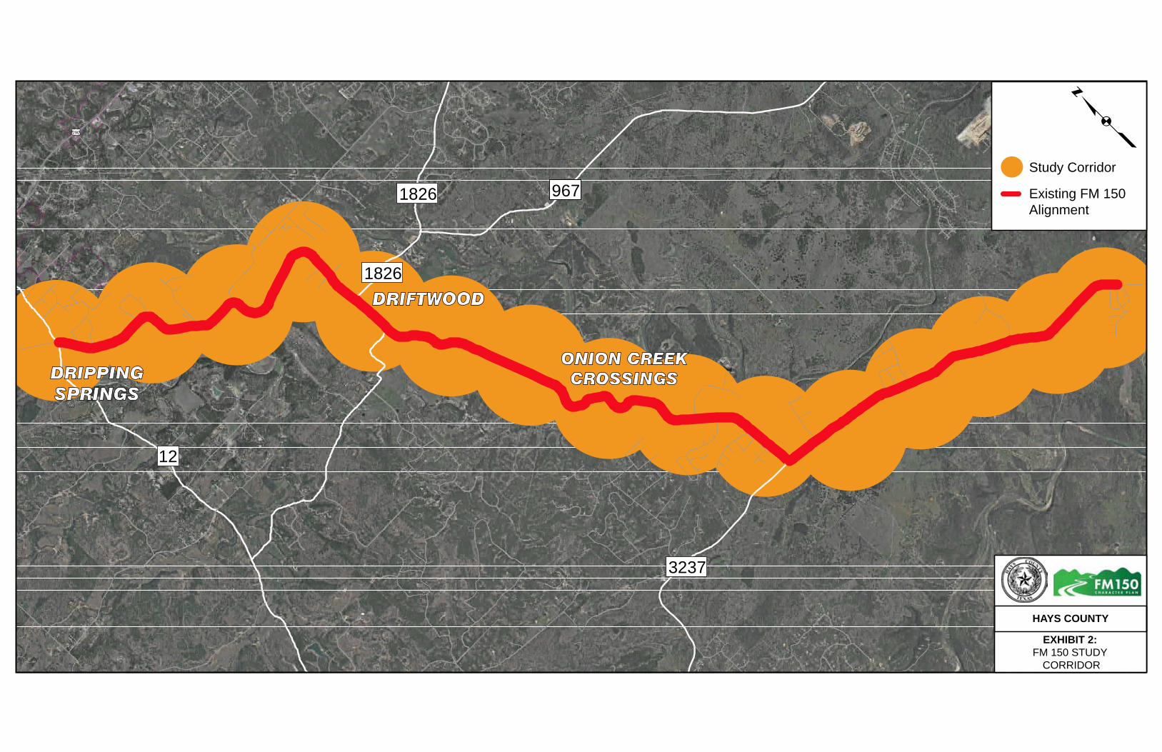
ONION CREEK CROSSINGS
DRIFTWOOD
£¤290
18261826 967
1826
12
3237
DRIPPING SPRINGS
HAYS COUNTY
EXHIBIT 2: FM 150 STUDY
CORRIDOR
pStudy Corridor
Existing FM 150 Alignment

Overview and Purpose
5
The HCTP identified FM 150 as a four-lane roadway with a 150 feet
right-of-way in the major thoroughfare plan. However, it did not
specifically define how those four-lanes would be provided, what the
roadway would be like, or the timing of the improvements. The right-of-
way width noted for FM 150 is for planning purposes only, and the
details of the roadway width and right-of-way are intended to be
worked out in more focused planning efforts, like the FM 150 West
Character Plan study. The map in Exhibit 1 shows the portion of the
HCTP major thoroughfare map around FM 150. As seen in the exhibit,
FM 150 and several of the roadways in the area are planned for future
expansion.
As the County’s Pass-Through Finance and Priority Road Bond programs
are moving into their final stages of development and construction, the
County has initiated its next roadway improvement program: the Hays
County-Texas Department of Transportation (TxDOT) Partnership
Program. The Partnership Program was formalized in the summer of
2013 when the Texas Transportation Commission committed $40
million of construction funding to the program. The County is funding
this study, as well as the FM 150 Alignment Study with a focus on
corridor preservation.
The County has been clear in the value and importance of the entire FM
150 corridor and its desire to develop solutions meeting the long-term
objectives of the HCTP. The County has also been clear that whatever
the ultimate solutions might be, it must address and honor the unique
and similar context zones within the corridor. Finally, solutions for this
portion of FM 150 must integrally tie into the FM 150 Alignment Study
west of downtown Kyle (“East”) project. As such, the vision for this west
segment of FM 150 must satisfy two needs:
1. the county-wide need to provide sufficient capacity to serve
forecasted growth, and
2. the more local need to provide safe and efficient travel without
compromising community character, integrity, values, and
assets.
This FM 150 West Character Plan study began in October 2014 with a
public workshop and the first phase was completed in early 2016. An
overview of the study schedule is provided in Exhibit 3, which highlights
public workshops and Citizen Advisory Panel (CAP) meetings throughout
the study. The first public workshop in October 2014 introduced the
study to the 129 community members in attendance by providing an
overview of the purpose of the study and the HCTP, along with county
growth projections to illustrate the future need for improvements. A
CAP of community stakeholders was appointed by the Hays County
Commissioner’s Court for the study team to present preliminary ideas
and themes to at regular progress meetings and gather valuable input
throughout the duration of the study. The second public workshop in
March 2015 presented large-scale maps of the corridor study area to
the 93 community members in attendance. The community members
provided 178 mapped comments and 35 written narrative comments
identifying sensitive areas of concern throughout the corridor.
Among the comments collected, key themes identified include the
community’s desire to maintain historical, environmental and
aesthetic characteristics of the corridor, concern over the treatment of
the existing low water crossings, the desire to preserve the Driftwood
community area, and the potential to consider other roadways and
future projects in the surrounding area to reduce the amount of
additional right-of-way needed along the existing FM 150 corridor.
In response to this public input the study team worked with the CAP to
establish study “context zones” to identify areas along the corridor with
unique values and characteristics, as well as identified a range of
potential FM 150 corridor concept improvements. The final public
workshop in October 2015 presented the draft findings and potential
concepts and gathered further input and comments from the 228
community members in attendance. The final CAP meeting in January
2016 reviewed the updates to the corridor concepts based on the public
meeting. More details on the public involvement are provided in this
report.
Exhibit 3. Project Schedule

Overview and Purpose
6
1.2 PURPOSE OF REPORT
This Corridor Features and Themes Report documents the stakeholder
outreach and technical activities undertaken to identify corridor-specific
and area wide qualities, attributes, and elements that should be
considered when investigating the range of alternatives to serve
existing and projected travel needs in the vicinity of the FM 150
corridor. The agreed upon features and themes form the basis for
considering how to best serve impending travel on FM 150 between
Dripping Springs and Kyle while protecting and preserving the unique
heritage, natural features, and historical character that makes the
corridor area such a special place. The features and themes form the
foundation for subsequently developing more specific plans for the
types of future projects and the sequencing of incremental construction
packages from the vicinity of Arroyo Ranch Road to RM 12 in Dripping
Springs. Incremental improvements that initially are founded on safety
and evolving to address travel demand will cumulatively serve the long
range FM 150 corridor capacity and safety performance needs. This
Corridor Features and Themes Report is a milestone and acknowledges
and values the extensive time and contributions of the public and
community to identify and document the existing features and themes
that will shape and form the future projects along and around the FM
150 corridor. This report will help memorialize the work done in this
phase of work and allow the findings and recommendations to be
appropriately integrated in future study and design efforts.
For reference, Volume 2 of this report (provided in a separate
document) includes more detailed technical documentation referenced
throughout this report.
1.3 NEXT STEPS
This Corridor Features and Themes Report is the first work product from
the FM 150 West Character Plan study. Moving forward, the County
intends to undertake more detailed planning processes for segments of
the study corridor that will further assess specific needs. While the
schedule for these next studies has not yet been defined, they are
expected to result in a master plan that identifies incremental
improvements to be made overtime. More detail on next steps is
presented in Section 8 of this document.

SECTION 2 Study Goals

Page left intentionally blank
Study Goals
9
2 STUDY GOALS The goals presented below build from the philosophy established as
part of the Hays County Transportation Plan (HCTP) and embrace the
concept of context sensitive solutions (CSS). CSS is a collaborative
approach to develop transportation facilities in a way that considers the
environmental, cultural, and historic character of the area. The County
and its citizens have been clear in communicating the value and
importance of the entire FM 150 Corridor and their desire to develop a
solution meeting the long-term objectives of the HCTP. The County and
its citizens have also been clear in stating that whatever the ultimate
solution might be, it must address and honor the unique and similar
context zones within the corridor. In addition, solutions for this portion
of FM 150 must integrally tie into the FM 150 Alignment Study to the
east. As such, the vision for this segment of FM 150 must satisfy two
needs: the county-wide need to provide sufficient capacity to serve
forecasted growth, and the more local need to provide safe and
efficient travel without compromising community character and
integrity, values, and assets. The overall goals are:
Support the safe and efficient movement of traffic within the
corridor and through Hays County. Aside from I-35, FM 150 is one
of three primary routes through the County, the others being RM 12
and US 290. FM 150 supports northwest and southeast movements
to and from Dripping Springs, Driftwood, Kyle, and I-35. As Hays
County and its cities continue to grow at rates above even those
experienced and expected for the all of Central Texas, FM 150 must
carry the commensurate growth of the traffic. The solutions must
serve this forecast demand in a sensible form that maintains the
unique and rich heritage and character of the area.
Minimize impacts to community resources, cohesion and
character. The County and its citizens understand the value of its
resources whether natural, cultural or visual, and the values of
community cohesion and character. The corridor study must go
beyond technical solutions and work with Hays County citizens to
provide solutions that best maintain the natural, environmental,
and cultural significance of the corridor. Meaningful and continuous
stakeholder engagement will take more time up front; however, in
the long run it will save time (and therefore money) by helping
produce a plan that is implementable, integrates County and
resident values and culture, and stands the test of time.
Support forecasted growth. Hays County is one the fastest growing
counties in Texas and in the Country. The growth is expected to
include an influx of residential population, as well as commercial
opportunities along the I-35 corridor and throughout the County.
Therefore, improvements to FM 150 are needed to support
forecasted growth and development. This growth is inevitable and
the plan must result in practical and right-sized solutions serving
anticipated needs while respecting the community.
Integrate principles of context sensitive solutions. The study
process should integrate a range of stakeholders, efficiently use
resources of all involved parties, and add lasting value to the
community.
Develop design options that align with the corridor character and
future objectives. Potential corridor improvements should be cost
effective, implementable, and maintainable, while meeting the
short and long-term transportation goals of the County.
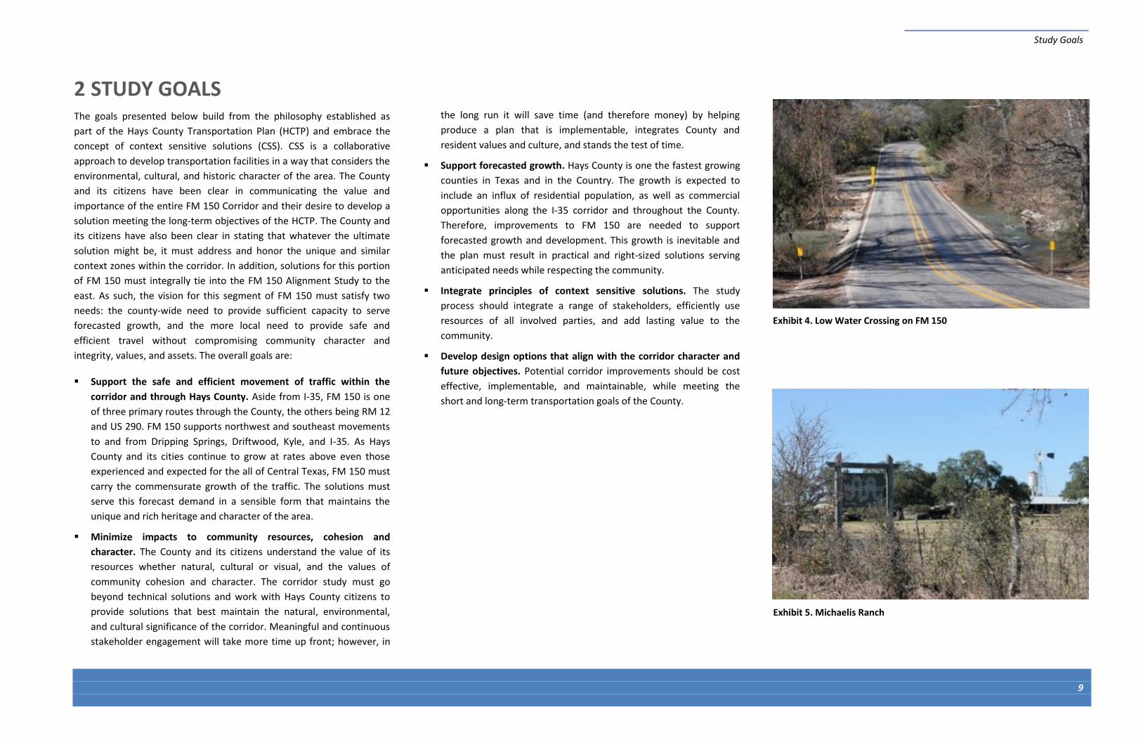
Exhibit 4. Low Water Crossing on FM 150
Exhibit 5. Michaelis Ranch

10
Page left intentionally blank

SECTION 3 Public Involvement

Page left intentionally blank

Public Involvement
13
3 PUBLIC INVOLVEMENT The Hays County Commissioners Court established the most important
guiding principle in developing the FM 150 West Character Plan: that it
be developed through a community-based process that is transparent,
open, and inclusive. The overarching ideas, concepts, and projects
identified must stand the test of time. To accomplish this, the Court
wanted the Plan developed through a series of phases with an engaging
public involvement program. The study team used many outreach tools
including developing and closely working with a CAP, conducting public
meetings and having outreach meetings with property owners and
interested citizens in the area. Study efforts included, coordinating with
the media to share information, developing a website, using postcards,
advertisements, and signage to promote study meetings, distributing
update emails to a growing contact list of over 400 contacts in the study
database, and open communications with the public. Below are
highlights of major activities and full public meeting reports are
available in Volume 3 of this report and on the study website:
www.improvefm150.com/nature-character-study.
3.1 CITIZEN ADVISORY PANEL ACTIVITIES
A CAP of 11 local stakeholders was established to represent corridor
stakeholders in the development of the Corridor Features and Themes
Report. The CAP helped to define the best methods and means of
communicating with the public at large. The CAP was selected and
appointed by Precinct 3 Commissioner Will Conley and Precinct 4
Commissioner Ray Whisenant. The CAP and study team met 11 times
throughout the development of this report. The following are some
highlights of CAP activities and contributions:
Highlights:
Shared valuable input on the area, driving patterns, unique
characteristics, and environmental considerations
Worked with the study team to identify context zones along the
corridor
CAP member developed a video flyover of the study to share input
and historical details
Served as a sounding board to improve the presentation of
materials in public meetings
Helped inform the community of the study and opportunities to
participate
Developed a Driftwood Heritage Corridor concept to identify and
preserve the Driftwood character which evolved into two different
bypass concepts
Table 1 on the following page provides a summary of CAP meetings held
throughout the study efforts.
Exhibit 6. CAP Meeting #6 – August 2015
Exhibit 7. CAP Meeting #6 – August 2015

Public Involvement
14
Table 1: CAP Meeting Summary
3.2 PUBLIC MEETINGS
Hays County hosted three public meetings at Thurman’s Mansion in
Driftwood, Texas that served as opportunities to meet with community
members, share study information and collect input. Feedback and
input were collected from the community through mapping exercises,
comment cards and extensive discussions with study team members.
These meetings allowed study team members to continue to update the
community on the progress of the study as well as the findings of the
CAP.
October 2014
The purpose of this meeting was to introduce the study and process to
the community, as well as seek applicants for the study CAP, which
worked closely with the county and study team throughout the study.
Highlights:
129 attendees
Received letters of intent to participate in CAP
Meeting Date Meeting Purpose Meeting Highlight
December 9, 2014 Introductory meeting Overview of the study and schedule
January 15, 2015 Principles of context sensitive solutions (CSS) & context zones CAP members introduced to CSS and context zones
February 19, 2015 Corridor features, Public Workshop #2 walk through CAP members participated in mapping exercise used at Workshop #2
April 16, 2015 Public Workshop #2 results, context zones, layering Overview of Workshop #2 results; open table discussion with study team & Hays County Commissioners
June 18, 2015 Hays County Transportation Plan, Driftwood Heritage Corridor CAP members participated in a work session on transition zones and intersection safety; 8-minute flyover video shared with team and CAP
July 15 & 16, 2015 Defining the future corridor Overview of speed and roadway geometry; bicycle and pedestrian travel
August 19 & 20, 2015 Defining the future corridor (Heritage Trail bypass concepts and existing FM 150 corridor)
CAP members participated in a mapping exercise which helped to develop two different bypass concepts
September 17, 2015 Corridor concept recap, Public Workshop #3 walk through Dry run of Public Workshop #3
January 21, 2016 Corridor features and themes completion CAP review of public input, review of concepts that will move forward, and wrap up of Phase I
Exhibit 8: Public Meeting #2 – March 2015
Public Involvement
15
March 2015
The purpose of this meeting was to share background information on
the corridor and to collect input. Attendees were able to share input
using two different methods, a comment card and mapping exercise.
Attendees were asked to leave comments on special characteristics and
features along the corridor using color-coded sticky notes that
represented five different categories: safety, historical and personal
property, environmental, mobility, and aesthetics. These notes were
then placed on large environmental data and context zones maps. The
study team then categorized and grouped these comments to identify
and analyze the corridor priorities and themes shared by participants.
Highlights:
95 attendees
178 comments collected from mapping exercise
35 general comments received via email and mail
Context zones confirmed through input received
Key themes heard from the workshop:
Desire to maintain historical, environmental,
and aesthetic characteristics of the corridor
Concerns about treatment of low water
crossings
Desire to preserve Driftwood – consider
designation of Driftwood
Suggestion to consider other roadways and
future projects in the area
Exhibit 9: Map Comments from Public Meeting #2
Exhibit 10: Public Meeting #2 Comments – Related Area Note: graph only shows areas with four or more comments
4
5
6
9
11
14
26
26
44
0 10 20 30 40 50
Darden Hill/150
3237/FM 150
Between Driftwood & Onion Creek XC
Historic property
1826
Personal property
Driftwood
Low water crossings
Corridor
Number of Comments
Area To Which The Comment Pertains
Exhibit 11: Public Meeting #2 Comments – Theme
Note: graph only shows themes with five or more comments
5
6
7
7
9
10
12
12
14
15
18
19
22
0 5 10 15 20 25
Aesthetics
Go around low water XC
Flooding
Improve intersection
Historic property
Extend 1826 to RR 12
Slow down
Wildlife
Don't add lanes
Preserve Driftwood
Preserve low water XC
Personal property
Consider other roadways
Occurrence
Recurring Themes

Public Involvement
16
October 2015
The purpose of this meeting was to share study information and
process, FM 150 corridor concepts, including concepts for other
connecting roadways such as FM 1826 and Elder Hill Road, and to
collect comments on the study.
Highlights:
228 attendees
185 comments received
A petition was received titled “We will not sell our property for an
unnecessary and unwanted road expansion” that generally opposed
extending FM 1826 near Elder Hill Road. There were 322 signatures
supporting the petition and 128 additional comments.
Key themes heard from the workshop:
Opposition to the FM 1826 Extension/Elder Hill
Desire to preserve Driftwood character
Concern and opposition to expanding FM 150
Concerns regarding the study process
Concerns regarding of growth projections and where growth will
occur
Concerns for wildlife, environmental features, and low water
crossings
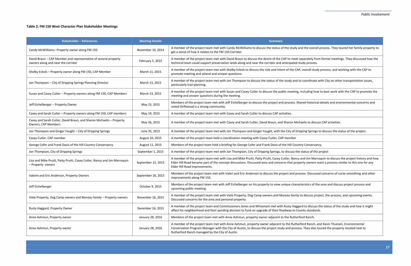
3.3 ADDITIONAL MEETINGS
The study team met with property owners and citizens who requested
individual meetings. The purpose of these meetings was to share study
information and details while collecting input and addressing individual
concerns. The study team and Hays County officials met with over 20
property owners and stakeholders in 19 separate meetings to discuss
the study process, and provide updates. The meetings are summarized
in Table 2.
62
25
4
34
38
13
16
34
121
128
7
11
6
17
11
0 20 40 60 80 100 120 140
Concern About the Need for FM 150 Improvements
Questions on Growth Projections
Concern for Water Availability
Character Plan Development Process
Preservation of Driftwood and Surrounding Areas
Quality of Life
Alternative Suggestions for Improvements
Preservation of Existing Character
FM 1826 Extension/Elder Hill Road Bypass
FM 1826 Extension Petition: 322 Signatures and 128…
Darden Hill Road Area
Private Property
Flooding and Water Quality Concerns
Concern for Wildlife and Environmental Features
Low Water Crossing
Recurring Topics of Comments Received
Exhibit 13: Comments - Reoccurring Topics
Exhibit 12: Public Meeting #3 – October 2015
Public Involvement
17
Table 2: FM 150 West Character Plan Stakeholder Meetings
Stakeholder – References Meeting Details Summary
Candy McWilliams– Property owner along FM 150 November 10, 2014 A member of the project team met with Candy McWilliams to discuss the status of the study and the overall process. They toured her family property to get a sense of how it relates to the FM 150 Corridor.
David Braun – CAP Member and representative of several property owners along and near the corridor
February 5, 2015 A member of the project team met with David Braun to discuss the desire of the CAP to meet separately from formal meetings. They discussed how the technical team could support preservation lands along and near the corridor and anticipated study process.
Shelby Eckols – Property owner along FM 150, CAP Member March 11, 2015 A member of the project team met with Shelby Eckols to discuss the role and intent of the CAP, overall study process, and working with the CAP to promote meeting and attend and answer questions.
Jon Thompson – City of Dripping Springs Planning Director March 13, 2015 A member of the project team met with Jon Thompson to discuss the status of the study and to coordinate with City on other transportation issues, particularly trail planning.
Susan and Casey Cutler – Property owners along FM 150, CAP Members March 13, 2015 A member of the project team met with Susan and Casey Cutler to discuss the public meeting, including how to best work with the CAP to promote the meeting and answer questions during the meeting.
Jeff Eichelberger – Property Owner May 15, 2015 Members of the project team met with Jeff Eichelberger to discuss the project and process. Shared historical details and environmental concerns and noted Driftwood is a strong community.
Casey and Sarah Cutler – Property owners along FM 150, CAP members May 19, 2015 A member of the project team met with Casey and Sarah Cutler to discuss CAP activities.
Casey and Sarah Cutler, David Braun, and Sharon Michaelis – Property Owners, CAP Members
May 26, 2015 A member of the project team met with Casey and Sarah Cutler, David Braun, and Sharon Michaelis to discuss CAP activities.
Jon Thompson and Ginger Faught – City of Dripping Springs June 25, 2015 A member of the project team met with Jon Thompson and Ginger Faught, with the City of Dripping Springs to discuss the status of the project.
Casey Cutler, CAP member August 10, 2015 A member of the project team held a coordination meeting with Casey Cutler, CAP member
George Cofer and Frank Davis of the Hill Country Conservancy August 11, 2015 Members of the project team held a briefing for George Cofer and Frank Davis of the Hill Country Conservancy.
Jon Thompson, City of Dripping Springs September 1, 2015 A member of the project team met with Jon Thompson, City of Dripping Springs, to discuss the status of the project
Lisa and Mike Pruitt, Patty Pruitt, Casey Cutler, Nancy and Jim Marroquin – Property owners
September 15, 2015 A member of the project team met with Lisa and Mike Pruitt, Patty Pruitt, Casey Cutler, Nancy and Jim Marroquin to discuss the project history and how Elder Hill Road became part of the concept discussions. Discussed area and concerns that property owners want a process similar to this one for any Elder Hill Road improvements.
Valerie and Eric Anderson, Property Owners September 16, 2015 Members of the project team met with Valeri and Eric Anderson to discuss the project and process. Discussed concerns of curve smoothing and other improvements along FM 150.
Jeff Eichelberger October 9, 2015 Members of the project team met with Jeff Eichelberger on his property to view unique characteristics of the area and discuss project process and upcoming public meeting.
Viele Property, Dog Camp owners and Moreau family – Property owners November 16, 2015 A member of the project team met with Viele Property, Dog Camp owners and Moreau family to discuss project, the process, and upcoming events. Discussed concerns for the area and personal property.
Rusty Haggard, Property Owner December 16, 2015 A member of the project team and Commissioners Jones and Whisenant met with Rusty Haggard to discuss the status of the study and how it might affect his neighborhood and their pending decision to fund an upgrade of their Roadway to County standards.
Anne Ashmun, Property owner January 28, 2016 Members of the project team met with Anne Ashmun, property owner adjacent to the Rutherford Ranch.
Anne Ashmun, Property owner January 28, 2016 A member of the project team met with Anne Ashmun, property owner adjacent to the Rutherford Ranch, and Kevin Thuesen, Environmental Conservation Program Manager with the City of Austin, to discuss the project study and process. They also toured the property located next to Rutherford Ranch managed by the City of Austin.

Page left intentionally blank

SECTION 4 Corridor Opportunities and Constraints

Page left intentionally blank

Corridor Opportunities and Constraints
21
4 CORRIDOR OPPORTUNITIES AND CONSTRAINTS
This section provides information on the existing FM 150 west corridor;
specifically land uses and cultural and environmental resources. In
addition, it summarizes the context zones that were developed based
on field observations and stakeholder input to identify areas with
similar and unique characteristics.
4.1 EXISTING LAND USES
The FM 150 corridor traverses portions of Dripping Springs, Driftwood,
and Kyle entirely within Hays County. Between these communities, land
uses in the corridor are characterized primarily as rural residential, as
well as some commercial in a matrix of agricultural (primarily ranching)
uses. The predominant agricultural land use is changing as large lot
residential subdivisions are platted and built along the corridor;
however, there are also conversions to open space/conservation
easements. Common agricultural land uses include grazing (cow-calf,
sheep and goat), vineyard, and wildlife focused operations. Although
deep soils are found, row crop agriculture is not currently represented
in the corridor’s agricultural landscape in this rocky hill country terrain.
A summary description of existing land uses and key features at
prominent locations along the corridor follows and the overall land use
study area is illustrated on Exhibit 14 (more detailed exhibits are
provided in Section 1 of Volume 2). In addition to this overview, more
detail regarding corridor land uses, including a list and mapped
locations of businesses, subdivisions, ranches, community resources and
open spaces can be found in Section 2 of Volume 2.
4.2 KEY FEATURES AND POINTS OF INTEREST
RM 12 and FM 150 intersection: This portion of the corridor has
primarily commercial and residential land use. One cemetery
(Philips Cemetery), two named residential (Springwood and Howard
Ranch Subdivision), and two businesses (Twisted X Brewing
Company and Bella Nido B&B) are located at the FM 150/RM 12
intersection. Hays County and the Dripping Springs envision a
connection of FM 150 and US 290 West in the future. This would
likely carry FM 150 beyond RM 12; where it would connect to US
290 has not been determined. Ultimately connecting FM 150 and
RM 12 to US 290 provides an opportunity for future transportation
projects to help relieve congestion by diverting the alignment and
associated traffic away from the existing RM 12/US 290 intersection.
This intersection has numerous land uses that will make this
challenging; including existing residential subdivisions, businesses
and Phillips Cemetery.
Community of Driftwood: Located on either side of the crossroads
of FM 150 and Elder Hill Road, this area is a small but important
community. The US Post Office for Dirftwood, the Driftwood
Community Center, and the Driftwood United Methodist Church
and Cemetery are key features in this area. These form the heart of
this historical community and are the center of activity for everyday
life there. As the traffic increases on FM 150, impacts to daily life
and special events in the area, including the annual Driftwood
Mayfest, raise questions about the best way to serve future FM 150
demands. Whether to bypass Driftwood or to develop a different
concept is a question that will be addressed further through more
detailed constraints analysis and extended conversations with the
community.
Two adjacent low water crossings of Onion Creek: These crossings
signify a valued natural component of the FM 150 corridor to the
citizens, many of whom wish for this portion of the roadway to
remain untouched. To most that pass through these crossings, it is a
place of striking beauty that has come to embody the very essence
of iconic, natural Texas Hill Country. However, during and after
heavy rain, these crossings flood and become impassable; therefore,
a reliable and safe solution needs to be considered for this area.
Solutions could include improvements to the existing crossing (e.g.,
raising the roadway elevation) or a new alignment around the
existing crossing.
FM 150 and FM 3237 intersection: This intersection provides a
unique challenge for the future of the FM 150 corridor, as the traffic
traveling southeast along FM 150 must come to a stop before
proceeding east on FM 150. The intersection has several
commercial businesses, Hays City Store and Precinct Line Beer &
Wine Company, which rely on the FM 150 and FM 3237 traffic.
Therefore, any modifications to this intersection must consider
smooth and consistent traffic flow while providing the commercial
businesses with the necessary infrastructure to flourish.
Michaelis Ranch, a National Register of Historic Places property:
Any changes to the FM 150 corridor in this area must consider the
significance of the property and other historical properties along the
corridor. While there are many known historical properties in the
area that are not on the National Register of Historical Places, they
are all immensely important to the citizens.
Transition to the FM 150 Alignment Study: Hays County is currently
involved in preliminary engineering and environmental
documentation of a proposed connection from I-35 to FM 150 in a
separate project from this FM 150 West Character Plan. It will be
critical to mesh the east and west corridor elements as seamlessly
as possible between suburban Kyle and the more rural attributes of
the western portion of the corridor.
4.3 CULTURAL AND ENVIRONMENTAL RESOURCES
Natural and human environmental resources evaluated, at this
preliminary level, include:
surface water resources,
groundwater resources,
vegetation,
wildlife,
community resources, and
cultural resources.

ELDER HILL R
D
DARDEN HILL RD
Study Area Terminus -Ranch Road 12
Study Area Terminus -Arroyo Ranch Road
3237
2770
16261826
12
967
150
£¤290
F i g u r eF i g u r e1 - 11 - 1
F i g u r eF i g u r e1 - 21 - 2
F i g u r eF i g u r e1 - 31 - 3
F i g u r eF i g u r e1 - 41 - 4
F i g u r eF i g u r e1 - 51 - 5
Key to Features
FM 150
Bypasses
Land Use TypesCemetery
Church
Commercial
Park
Public Facility
Residential
School
Utility
WOne inch equals 1.25 miles
0 0.625 1.25
Miles
Figure 2
EXHIBIT 14. LAND USE FM 150 CORRIDOR
HAYS COUNTY

Corridor Opportunities and Constraints
23
A full biological (including all listed species) and cultural resources
analysis, as well as socioeconomic and demographic analyses for
Environmental Justice (EJ) and Limited English Proficiency (LEP) will be
necessary during future environmental document preparation stages as
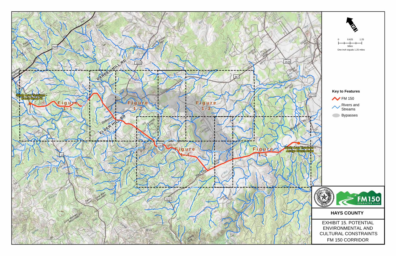
projects are identified. Exhibit 15 illustrates the overall study area of
potential environmental and cultural resource constraints. Detailed
figures illustrating these potential constraints are provided as Section 3
of Volume 2.
Water Resources
Surface Water
The FM 150 corridor traverses the Onion Creek watershed in the
Colorado River Basin and the Blanco River watershed within the
Guadalupe River Basin. Multiple tributaries to Onion Creek and
associated floodplains cross the study corridor and Onion Creek itself
crosses FM 150 three times within the study corridor. Other named
creeks within the corridor include Flat Creek, Rocky Branch and Yorks
Creek. The stretch of Onion Creek within the corridor has been
identified by Texas Parks and Wildlife Department (TPWD, Reference 2)
as having unique ecological value due to high water quality, diverse
aquatic life and high aesthetic value. Future projects would require
further analysis to ensure compliance with local, State and Federal laws,
such as Sections 404, 401, and 402 of the Clean Water Act, as well as
coordination with the local floodplain administrator.
Groundwater
Portions of the FM 150 study corridor are underlain by the Edwards
Aquifer; one of the most productive aquifers in the country. The Barton
Springs Segment of the Edwards Aquifer lies beneath the FM 150
corridor and is the middle of three hydrogeologically distinct segments.
This segment flows from an area north of Kyle to its major discharge at
Barton Springs in Austin, Texas. This aquifer is composed of partially
dissolved limestone making it highly permeable and therefore
vulnerable to surface pollutants. Because of this permeability, water
levels and spring flows respond quickly to rainfall, drought, and
pumping (Reference 3). Recharge to the Edwards is primarily from
percolation of surface water through faults and fractures, direct
infiltration of precipitation, and internal flow of groundwater from the
adjacent Trinity Aquifer (Reference 4). The aquifer’s primary use is for
municipal, irrigation, and recreational purposes (Reference 3). A review
of the Texas Commission on Environmental Quality and the Texas Water
Development Board records was conducted to identify documented
water well locations. Documented wells, springs, and known cave areas
that occur within the FM 150 study corridor are illustrated in Figures 1-1
through 1-5 in Section 3 of Volume 2.
Title 30 Texas Administrative Code (TAC) Chapter 213 defines rules that
address activities that could pose a threat to water quality in the
Edwards Aquifer, including wells and springs fed by the aquifer and
water sources to the aquifer, including upland areas draining directly to
it and surface streams. These rules, often referred to as the Edwards
Aquifer Rules, apply specifically to the Edwards Aquifer in eight counties
including Medina, Bexar, Comal, Kinney, Uvalde, Hays, Travis and
Williamson. The rules are not intended for any other aquifers in Texas.
Portions of the study corridor are located within the Edwards Aquifer
Recharge, Contributing and Transition Zones (Figures 1-1 through 1-5 in
Section 3 of Volume 2); therefore, the Edwards Aquifer Rules, as
described in 30 TAC 213, would apply to future projects within the FM
150 study corridor.
Vegetation
A description of FM 150 vegetation from both regional and site specific
perspectives follows. Site specific vegetation descriptions are based
upon observations made from FM 150 and work done on properties
along the corridor. The FM 150 study corridor occurs within the
Edwards Plateau ecoregion. This ecoregion is primarily a dissected
limestone plateau that is hillier to the south and east where it is easily
distinguished from bordering ecological regions by a sharp fault line.
The region contains a sparse network of perennial streams. Covered by
juniper-oak savanna and mesquite-oak savanna, most of the region is
used for grazing beef cattle, sheep, goats, exotic game mammals, and
wildlife (Reference 5). The Ecological Mapping Systems of Texas (EMST)
GIS database was searched and categorizes vegetation within the FM
150 Corridor into 35 different communities (Reference 6). These
vegetation communities are listed in Section 4 of Volume 2. According
to The Vegetation Types of Texas (Reference 7), the FM 150 corridor is
situated within a transitional area between Live Oak-Ashe Juniper Parks
and Live Oak-Mesquite-Ashe Juniper Parks. These areas vary from open
savannah to nearly 100 percent closed canopy oak-juniper woodland
with a diverse deciduous tree and understory component.
Dominant upland tree species include:
Ashe juniper (Juniperus ashei)
Plateau live oak (Quercus fusiformis)
Texas oak (Q. texana)
Shin oak (Q. sinuata var. breviloba)
Post oak (Q. stellata)
Cedar elm (U. crassifolia)
Texas ash (Fraxinus texensis)
Cat claw acacia (Acacia roemeriana)
Honey mesquite (Prosopis glandulosa)
Typical understory species include saplings of the aforementioned trees,
wafer ash (Ptelea trifoliata), yaupon (Ilex vomitoria), elbow bush
(Forestiera pubescens), and Lindheimer’s silk tassel (Garrya ovata ssp.
lindheimeri). Giant ball moss (Tillandsia baileyi) is commonly found on
both overstory and understory trees.
The same species occur in the riparian corridors and canyons along with
more mesic adapted tree and shrub species such as:
Bald cypress (Taxodium distichum)
Pecan (Carya illinoensis)
Black willow (Salix nigra)
Bur oak (Q. macrocarpa)
Escarpment cherry (Prunus serotina)
Sycamore (Platanus occidentalis)
Carolina buckthorn (Frangula caroliniana)
Sugar hackberry (Celtis laevigata)
Deciduous yaupon (I. decidua)
Buttonbush (Cephalanthus occidentalis)
Wafer ash
FM 150
Rivers andStreamsBypasses
!(
!(
ELDER HILL R
D
DARDEN HILL RD
Study Area Terminus -Ranch Road 12
Study Area Terminus -Arroyo Ranch Road
3237
2770
16261826
12
967
150
£¤290
South Oni
on
CreekOnionCree k
North Gatlin Cre ek
Onion Creek
LittleB
arto
nCr
eek
So uth
Gatlin Creek
Yorks Creek
J ack son Branch OnionCree k
Onion Creek
Onion C reek
Pier Branch
Oni
onCre
ek
Rocky Bran ch
FlatCreek
Onion Creek
Oni
onC
reek
Gatlin Creek
On ion Creek
Mu s tan gBr anc h
Li ttle Bear C reek
Roy Branch
Blanco RiverHalifax Creek
Plum C reek
F i g u r eF i g u r e1 - 11 - 1
F i g u r eF i g u r e1 - 21 - 2
F i g u r eF i g u r e1 - 31 - 3
F i g u r eF i g u r e1 - 41 - 4
F i g u r eF i g u r e1 - 51 - 5
Key to Features
Figure 3
EXHIBIT 15. POTENTIAL ENVIRONMENTAL AND
CULTURAL CONSTRAINTS
FM
150 CORRIDOR
HAYS COUNTY
WOne inch equals 1.25 miles
0 0.625 1.25
Miles

Corridor Opportunities and Constraints
25
Typical understory species include saplings of the aforementioned trees,
redbud (Cercis canadensis var. texensis), yaupon, and elbow bush.
Woody vines are most commonly found along tributary and creek
corridors and include grapevines (Vitis sp.), greenbriar (Smilax
bonanox), and poison ivy.
Typical woody species along woodland edges and/or in open areas
include:
Agarita (Mahonia trifoliolata)
Mountain laurel (Sophora secundiflora)
Eve’s necklace (Sophora affinis)
Texas persimmon (Diospyros texana)
Texas kidneywood (Eysenhardtia texanum)
Twistleaf yucca (Yucca rupicola)
Prickly pear (Opuntia englemannii)
Pencil cactus (O. leptocaulis)
Horse crippler (Echinocactus texensis)
Lace cactus (Echinocereus reichenbachii)
Typical woody species in disturbed and/or open areas include
chinaberry (Melia azedarach), poverty weed (Baccharis neglecta), and
fragrant mimosa (Mimosa borealis).
Common herbaceous species in shaded areas and/or along riparian
corridors include:
Cedar sedge (Carex planostachys)
Cedar sage (Salvia roemeriana)
Annual pennyroyal (Hedeoma acinoides)
Scarlet leatherflower (Clematis texensis)
Widow’s tears (Commelina erecta)
Frostweed (Verbesina virginica)
Lanceleaf frogfruit (Phyla lanceolata)
Canada wildrye (Elymus canadensis)
Virginia wildrye (E. virginicus)
Switchgrass (Panicum virgatum)
Green milkweed vine (Matelea reticulata)
Switchgrass, frogfruit, and loose-flower water willow (Justicia ovata) are
the dominant herbaceous species within creek banks.
Typical upland herbaceous species include:
Little bluestem (Schizachyrium scoparium)
Texas wintergrass (Nassella leucotricha)
King Ranch bluestem (Bothriochloa ischaemum)
Silver bluestem (B. laguroides)
Side-oats grama (Bouteloua curtipendula)
Texas grama (B. rigidiseta)
Hairy grama (B. hirsuta)
White milkwort (Polygala alba)
Redseed plantain (Plantago rhodospermum)
Common mullein (Verbascum thapsus)
Texas bluebonnet (Lupinus texensis)
Prairie verbena (Verbena bipinnatifida)
Indian blanket (Gaillardia pulchella)
Plains coreopsis (Coreopsis tinctoria var. tinctoria)
Mexican hat (Ratibida columnaris)
Beebalm (Monarda sp.)
Slender-leaf bitterweed (Tetraneuris linearis)
White heliotrope (Heliotropium tenellum)
Butterfly milkweed (Asclepias tuberosa)
Texas thistle (Cirsium texanum)
White prickly poppy (Argemone albiflora)
Orange zexmenia (Wedelia texana)
Rabbit tobacco (Evax prolifera)
Drummond’s skullcap (Scutellaria drummondii)
Lady bird’s centaury (Centaurium texensis)
Texas lantana (Lantana texensis)
Wildlife
A high diversity of wildlife species exist in Central Texas. Vertebrate
species known to occur within Hays County includes 44 mammals, 32
snakes, 17 lizards, 11 turtles, 20 frogs and toads, seven salamanders and
the American alligator (Reference 8, Reference 9). Additionally, 431
species of birds have been documented to occur within the Edwards
Plateau Ecoregion (Reference 10). Multiple federal and state-listed
threatened, endangered or candidate species for federal listing, as well
as species of greatest conservation need, have been documented by
both the U.S. Fish and Wildlife Service and Texas Parks and Wildlife as
potentially occurring in Hays County. One species in particular, the
federally listed endangered Golden-cheeked Warbler (Setophaga
chrysoparia), is known to occur within the study corridor. Figures 1-1
through 1-5 in Section 3 of Volume 2 illustrates the areas of potential
low, medium, or high quality habitat for this species within the study
corridor. Future projects would require further analyses of potential
impacts to wildlife including all potentially occurring listed species.
These analyses would be conducted under U.S. Fish and Wildlife and
TPWD regulations along with any other required policies.
Open Space and Preserves
Due to the rural, undeveloped nature of the corridor and its propensity
for recharge, it has been a conservation priority for the City of Austin
(COA) and various other entities for nearly 20 years. In 1998, the COA
proposed bond funding to acquire and manage land over the recharge
and contributing zones to enhance water quality and quantity in the
aquifer. This bond item passed and the Water Quality Protection Land
program was formed within the Austin Water Utility. To date, the
program manages over 26,000 acres (9,000 in fee simple and 17,000 in
conservation easements) (Reference 11). Similarly, the Hill Country
Conservancy (HCC) was formed in 1999 to preserve large tracts of land
to conserve critical water features, preserve outdoor recreation
opportunities, and help maintain the Hill Country’s unique quality of
life. Multiple public and private preserves and conservation easements
occur within or adjacent to the study corridor. Mapped data acquired
from the COA and the HCC illustrating the location of preserves and
conservation easements within the study corridor are presented in
Figures 1-1 through 1-5 in Section 3 of Volume 2.

Corridor Opportunities and Constraints
26
Cultural Resources
The FM 150 corridor has many documented prehistoric and historic
sites. A brief overview of these two types of sites is followed by an
overview of known sites along the corridor. This is not an intensive
survey or a complete listing of potential sites in the corridor as much of
it has not been surveyed as part of this study.
Prehistoric archeological sites in central Texas are primarily open
campsites situated on alluvial terraces adjacent to rivers and streams
and, on occasion, on upland areas such as bluffs and hill tops. Typically,
such sites are characterized by chert chipping debris, stone tools,
burned rock, fragmented animal bone and, less frequently, charred
plant remains. Burned rock middens are a common phenomenon to the
central Texas area as well as in the northern extent of the South Texas
Plains. Usually, burned rock middens are found in terrace or upland
settings and can range in size from a few meters to a hectare. Often,
these sites represent multiple occupations dating to different temporal
periods. Quarry and lithic reduction sites are also fairly common in
central Texas. These sites may represent specialized knapping events of
limited duration (lithic scatters), such as retooling, or raw material
procurement and stone tool manufacture. In addition to these site
types, small, temporary camps, generally comprised of a few hearths,
flakes, and the occasional projectile point, are found within the region.
Rarely, burial sites and rockshelter sites have also been documented in
central Texas (Reference 12).
Historic archeological sites are common to central Texas; homestead
and tenant farm settlements dating to the late nineteenth century are
the most common. These sites are typically located on hilltops or
hillsides overlooking springs or creeks and contain a combination of
foundation remnants, cisterns, wells, barns, and artifact scatters.
Historic period cemeteries and family burial plots are also common.
These locales do not always contain grave markers and mapped
boundaries are often inaccurate; therefore, verification of historic
cemetery boundaries is typically necessary prior to ground disturbance
within the vicinity. Less common to the area are sites pertaining to the
Spanish Colonial Period or the Mexican Period as well as military sites.
Two recorded archeological sites occur adjacent to FM 150 and ten
recorded sites occur within the potential bypass study corridor. While
the locations of these archeological sites are known by the study team,
they are not presented in maps available to the public to protect their
integrity. Two National Register Districts, Camp Ben McCullough and
Michaelis Ranch, are identified in the Atlas within the study corridor.
Camp Ben McCullough is located within the potential bypass study
corridor along Onion Creek and just west of FM 967 and south of FM
1826. Michaelis Ranch is located just east of the southern terminus of
the study corridor along FM 150. Five additional resources identified in
the Atlas, all bearing historical marker designations, are also located
along the FM 150 study corridor: The Driftwood Church, the Driftwood
Cemetery, and the Phillips Cemetery, Camp Ben McCullough, and the
home of Joseph B. Rogers. Driftwood Church was originally established
as a Methodist Episcopal Church in 1884, moving services from the
Reaves School located approximately one mile to the north. Following a
fire that destroyed the local Baptist church building in 1911, this
structure was shared by the two denominations with both continuing to
hold services here today. The Driftwood Cemetery, in use since 1884, is
located behind the present day location of the Driftwood Church and
contains reinternments from the Old Community Cemetery, located
approximately one mile north, near the Reaves School (Reference 13).
However, according to Rogers (Reference 14) not all the burials from
Old Community were moved with one double grave marker remaining
behind with evidence of unmarked graves remaining as well.
The Phillips Cemetery is located just south of Dripping Springs and west
of RM 12. This cemetery was established in 1880 on land deeded by
John and Nancy Phillips to the Methodist Episcopal Church (Reference
15). The Methodist Church later donated the cemetery to the local
community in 1940. Initially, a small church was built on this property
though in 1901 land for a new church building was acquired and the
original building was sold and moved. The internment of B. G. Sorrell,
who died on March 13, 1880, is the earliest documented burial and
many of the graves here are those of the early settlers to the area.
As mentioned above, Camp Ben McCullough is located within the
potential bypass study corridor along Onion Creek and just east of the
intersection of FM 1826 and FM 967. In the summer of 1896,
Confederate veterans and their families gathered near Martin Spring
and campsite on Onion Creek and formally organized the Camp Ben
McCulloch Chapter of the United Confederate Veterans. These grounds
were purchased by the organization in 1904 and have continued as the
site of the annual reunion with the exception of one year during World
War I (Reference 13).
Joseph B. Rogers was born in 1833 and served with Terry’s Texas
Rangers during the Civil War. In the early 1870’s he hired local workmen
to build his native limestone home. The family has preserved the
structure and it became a recorded Texas historic landmark in 1975
(Reference 13). Approximately 100 yards in front of the house a ring of
large rocks encircles a small plot of land marking a private burial site.
Here within two graves, three children of the Peter Klein family are
buried. Though the graves are unmarked, Rogers (1970) notes that they
likely passed during the Civil War.
Rogers (Reference 14) also notes the presence of two small, historic-
period cemeteries in the FM 150 study area vicinity. The Perry Cemetery
is located on property owned by the Collins family. Just east of the main
residence members of the Perry family are buried. Three grave markers
date this cemetery to the late nineteenth century. The Reaves
graveyard is located on property that, as of 2009, was owned by Scott
Marshall (Reference 16). Dates from ten headstones at this graveyard
date the interments from 1870-1885.
During the public involvement process for this study, the local
community including members of the CAP and the Driftwood Historical
Conservation Society also identified several additional resources within
the study corridor. These include a historic rock wall, the Bella Nido B &
B, and the Butler Cemetery. The historic rock wall is located adjacent to
FM 150 on a portion of William B Travis’ original league of land acquired
in 1835. According to the Bella Nido B&B website (Reference 17), the
house was built in 1905 and has since been restored. An old rock barn
also sits on the same property as the Bella Nido house. The Butler
Cemetery is an approximately two acre cemetery of historic age located
just south of the double low water crossings of Onion Creek and east of
FM 150. The land this cemetery is on was originally obtained by J.C.
Johnson in 1855 from Charles Travis, the son of William B. Travis
(Reference 15). As previously stated, a full cultural resources analysis
would be necessary during the environmental document preparation
stage once a future project or projects is/are identified.
Corridor Opportunities and Constraints
27
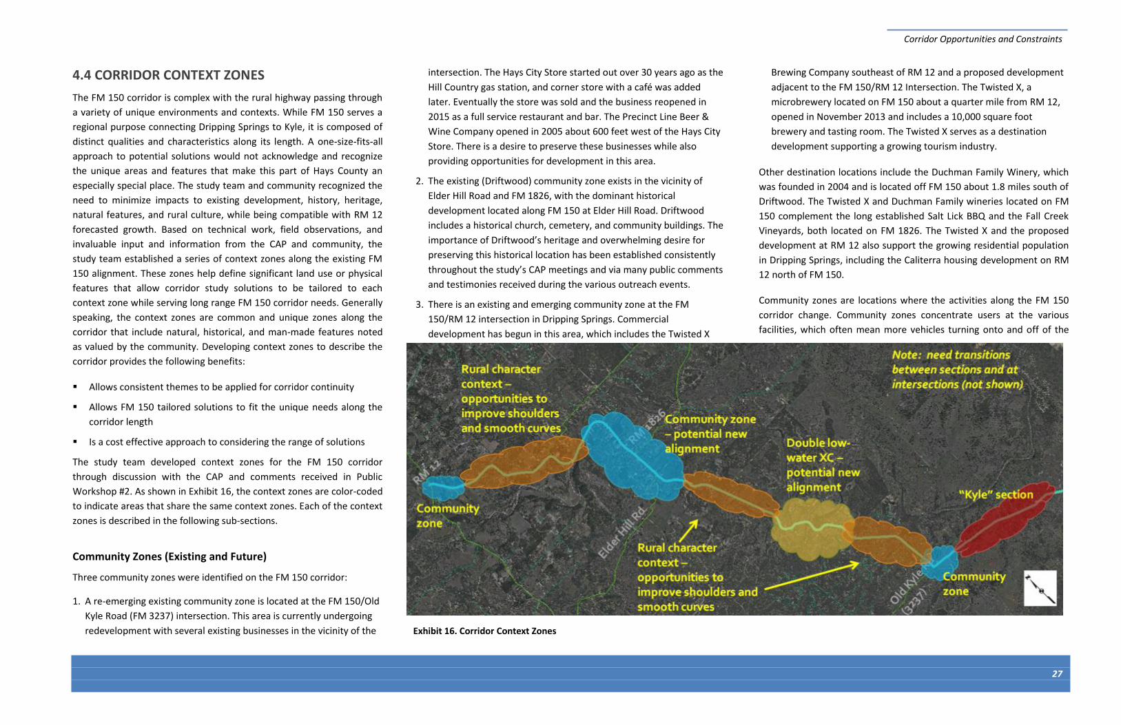
Exhibit 16. Corridor Context Zones
4.4 CORRIDOR CONTEXT ZONES
The FM 150 corridor is complex with the rural highway passing through
a variety of unique environments and contexts. While FM 150 serves a
regional purpose connecting Dripping Springs to Kyle, it is composed of
distinct qualities and characteristics along its length. A one-size-fits-all
approach to potential solutions would not acknowledge and recognize
the unique areas and features that make this part of Hays County an
especially special place. The study team and community recognized the
need to minimize impacts to existing development, history, heritage,
natural features, and rural culture, while being compatible with RM 12
forecasted growth. Based on technical work, field observations, and
invaluable input and information from the CAP and community, the
study team established a series of context zones along the existing FM
150 alignment. These zones help define significant land use or physical
features that allow corridor study solutions to be tailored to each
context zone while serving long range FM 150 corridor needs. Generally
speaking, the context zones are common and unique zones along the
corridor that include natural, historical, and man-made features noted
as valued by the community. Developing context zones to describe the
corridor provides the following benefits:
Allows consistent themes to be applied for corridor continuity
Allows FM 150 tailored solutions to fit the unique needs along the
corridor length
Is a cost effective approach to considering the range of solutions
The study team developed context zones for the FM 150 corridor
through discussion with the CAP and comments received in Public
Workshop #2. As shown in Exhibit 16, the context zones are color-coded
to indicate areas that share the same context zones. Each of the context
zones is described in the following sub-sections.
Community Zones (Existing and Future)
Three community zones were identified on the FM 150 corridor:
1. A re-emerging existing community zone is located at the FM 150/Old
Kyle Road (FM 3237) intersection. This area is currently undergoing
redevelopment with several existing businesses in the vicinity of the
intersection. The Hays City Store started out over 30 years ago as the
Hill Country gas station, and corner store with a café was added
later. Eventually the store was sold and the business reopened in
2015 as a full service restaurant and bar. The Precinct Line Beer &
Wine Company opened in 2005 about 600 feet west of the Hays City
Store. There is a desire to preserve these businesses while also
providing opportunities for development in this area.
2. The existing (Driftwood) community zone exists in the vicinity of
Elder Hill Road and FM 1826, with the dominant historical
development located along FM 150 at Elder Hill Road. Driftwood
includes a historical church, cemetery, and community buildings. The
importance of Driftwood’s heritage and overwhelming desire for
preserving this historical location has been established consistently
throughout the study’s CAP meetings and via many public comments
and testimonies received during the various outreach events.
3. There is an existing and emerging community zone at the FM
150/RM 12 intersection in Dripping Springs. Commercial
development has begun in this area, which includes the Twisted X
Brewing Company southeast of RM 12 and a proposed development
adjacent to the FM 150/RM 12 Intersection. The Twisted X, a
microbrewery located on FM 150 about a quarter mile from RM 12,
opened in November 2013 and includes a 10,000 square foot
brewery and tasting room. The Twisted X serves as a destination
development supporting a growing tourism industry.
Other destination locations include the Duchman Family Winery, which
was founded in 2004 and is located off FM 150 about 1.8 miles south of
Driftwood. The Twisted X and Duchman Family wineries located on FM
150 complement the long established Salt Lick BBQ and the Fall Creek
Vineyards, both located on FM 1826. The Twisted X and the proposed
development at RM 12 also support the growing residential population
in Dripping Springs, including the Caliterra housing development on RM
12 north of FM 150.
Community zones are locations where the activities along the FM 150
corridor change. Community zones concentrate users at the various
facilities, which often mean more vehicles turning onto and off of the
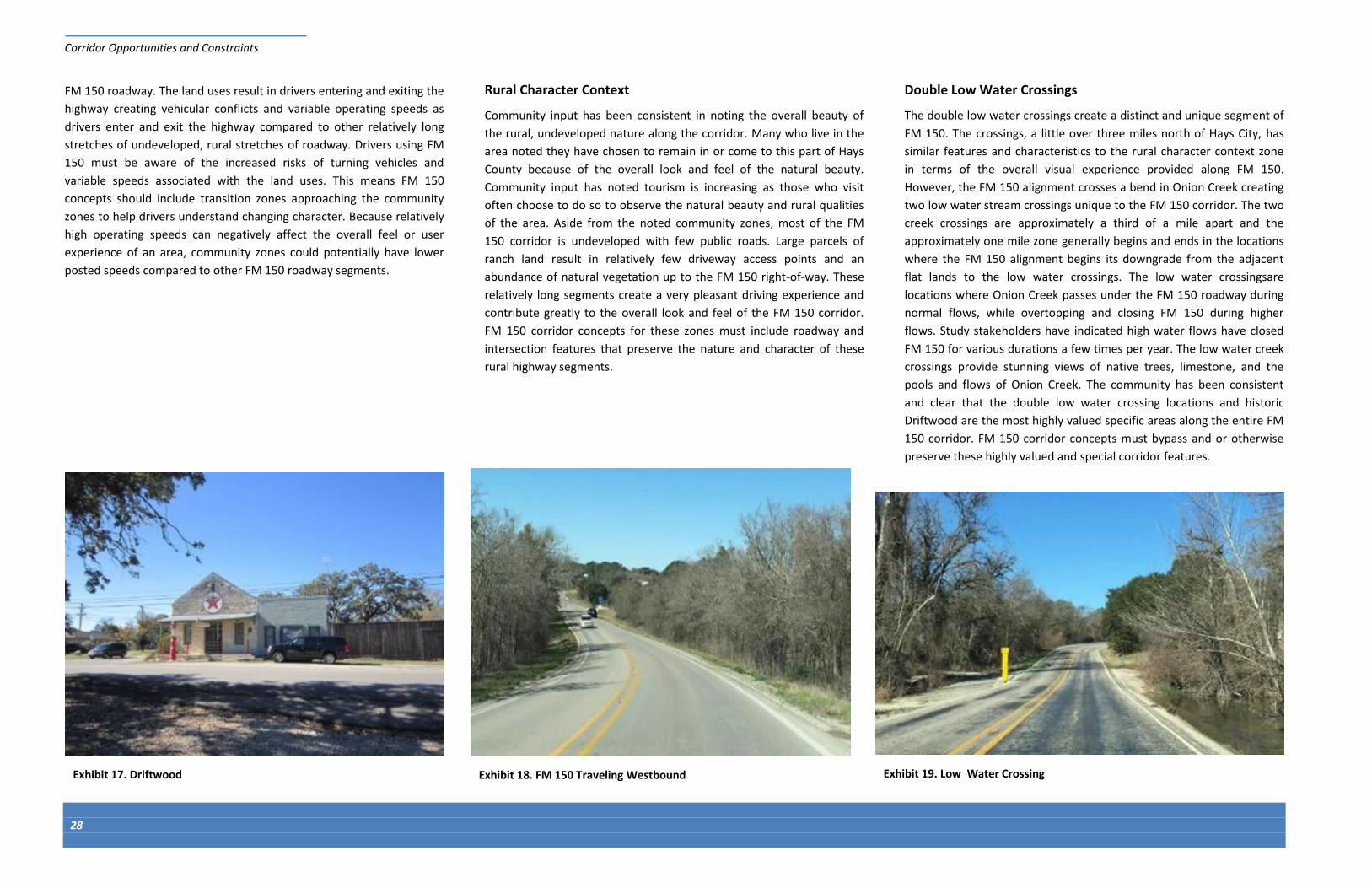
Corridor Opportunities and Constraints
28
Exhibit 19. Low Water Crossing
FM 150 roadway. The land uses result in drivers entering and exiting the
highway creating vehicular conflicts and variable operating speeds as
drivers enter and exit the highway compared to other relatively long
stretches of undeveloped, rural stretches of roadway. Drivers using FM
150 must be aware of the increased risks of turning vehicles and
variable speeds associated with the land uses. This means FM 150
concepts should include transition zones approaching the community
zones to help drivers understand changing character. Because relatively
high operating speeds can negatively affect the overall feel or user
experience of an area, community zones could potentially have lower
posted speeds compared to other FM 150 roadway segments.
Rural Character Context
Community input has been consistent in noting the overall beauty of
the rural, undeveloped nature along the corridor. Many who live in the
area noted they have chosen to remain in or come to this part of Hays
County because of the overall look and feel of the natural beauty.
Community input has noted tourism is increasing as those who visit
often choose to do so to observe the natural beauty and rural qualities
of the area. Aside from the noted community zones, most of the FM
150 corridor is undeveloped with few public roads. Large parcels of
ranch land result in relatively few driveway access points and an
abundance of natural vegetation up to the FM 150 right-of-way. These
relatively long segments create a very pleasant driving experience and
contribute greatly to the overall look and feel of the FM 150 corridor.
FM 150 corridor concepts for these zones must include roadway and
intersection features that preserve the nature and character of these
rural highway segments.
Double Low Water Crossings
The double low water crossings create a distinct and unique segment of
FM 150. The crossings, a little over three miles north of Hays City, has
similar features and characteristics to the rural character context zone
in terms of the overall visual experience provided along FM 150.
However, the FM 150 alignment crosses a bend in Onion Creek creating
two low water stream crossings unique to the FM 150 corridor. The two
creek crossings are approximately a third of a mile apart and the
approximately one mile zone generally begins and ends in the locations
where the FM 150 alignment begins its downgrade from the adjacent
flat lands to the low water crossings. The low water crossingsare
locations where Onion Creek passes under the FM 150 roadway during
normal flows, while overtopping and closing FM 150 during higher
flows. Study stakeholders have indicated high water flows have closed
FM 150 for various durations a few times per year. The low water creek
crossings provide stunning views of native trees, limestone, and the
pools and flows of Onion Creek. The community has been consistent
and clear that the double low water crossing locations and historic
Driftwood are the most highly valued specific areas along the entire FM
150 corridor. FM 150 corridor concepts must bypass and or otherwise
preserve these highly valued and special corridor features.
Exhibit 17. Driftwood Exhibit 18. FM 150 Traveling Westbound
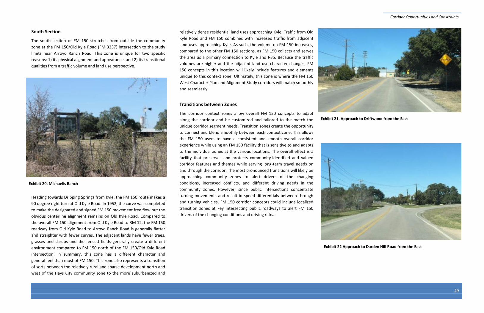
Corridor Opportunities and Constraints
29
Exhibit 20. Michaelis Ranch
South Section
The south section of FM 150 stretches from outside the community
zone at the FM 150/Old Kyle Road (FM 3237) intersection to the study
limits near Arroyo Ranch Road. This zone is unique for two specific
reasons: 1) its physical alignment and appearance, and 2) its transitional
qualities from a traffic volume and land use perspective.
Heading towards Dripping Springs from Kyle, the FM 150 route makes a
90 degree right turn at Old Kyle Road. In 1952, the curve was completed
to make the designated and signed FM 150 movement free flow but the
obvious centerline alignment remains on Old Kyle Road. Compared to
the overall FM 150 alignment from Old Kyle Road to RM 12, the FM 150
roadway from Old Kyle Road to Arroyo Ranch Road is generally flatter
and straighter with fewer curves. The adjacent lands have fewer trees,
grasses and shrubs and the fenced fields generally create a different
environment compared to FM 150 north of the FM 150/Old Kyle Road
intersection. In summary, this zone has a different character and
general feel than most of FM 150. This zone also represents a transition
of sorts between the relatively rural and sparse development north and
west of the Hays City community zone to the more suburbanized and
relatively dense residential land uses approaching Kyle. Traffic from Old
Kyle Road and FM 150 combines with increased traffic from adjacent
land uses approaching Kyle. As such, the volume on FM 150 increases,
compared to the other FM 150 sections, as FM 150 collects and serves
the area as a primary connection to Kyle and I-35. Because the traffic
volumes are higher and the adjacent land use character changes, FM
150 concepts in this location will likely include features and elements
unique to this context zone. Ultimately, this zone is where the FM 150
West Character Plan and Alignment Study corridors will match smoothly
and seamlessly.
Transitions between Zones
The corridor context zones allow overall FM 150 concepts to adapt
along the corridor and be customized and tailored to the match the
unique corridor segment needs. Transition zones create the opportunity
to connect and blend smoothly between each context zone. This allows
the FM 150 users to have a consistent and smooth overall corridor
experience while using an FM 150 facility that is sensitive to and adapts
to the individual zones at the various locations. The overall effect is a
facility that preserves and protects community-identified and valued
corridor features and themes while serving long-term travel needs on
and through the corridor. The most pronounced transitions will likely be
approaching community zones to alert drivers of the changing
conditions, increased conflicts, and different driving needs in the
community zones. However, since public intersections concentrate
turning movements and result in speed differentials between through
and turning vehicles, FM 150 corridor concepts could include localized
transition zones at key intersecting public roadways to alert FM 150
drivers of the changing conditions and driving risks.
Exhibit 21. Approach to Driftwood from the East
Exhibit 22 Approach to Darden Hill Road from the East

Page left intentionally blank

SECTION 5 Existing Conditions

Page left intentionally blank

Existing Conditions
33
Table 3. Average Weekday Daily Volumes by Direction
Location Northbound Southbound Total
1 3,220 3,260 6,480
2 2,600 2,610 5,270
3 2,970 2,850 5,820
4 2,550 2,390 4,940
5 EXISTING CONDITIONS The FM 150 corridor has evolved over time, likely beginning as an
unpaved path designed to provide efficient and accessible connections.
Most likely, the corridor was never formally designed to meet certain
standard lane widths, shoulder widths, curve radii, or other geometric
requirements. There is evidence of spot improvements on the corridor
over the last century, such as widening of tight curves and widening of
lanes and shoulders in some locations. To help inform the study of FM
150 and identification of future improvements, a comprehensive
existing conditions assessment addressed:
Intersection volumes and operations
Roadway volumes
Crash history
Speeds
Cross section
The following sub-sections describe the results of this assessment.
5.1 INTERSECTION VOLUMES AND OPERATIONS
The study team collected data at key intersections on the roadway to
assess intersection capacity and identify key movements at each
intersection during the peak hours. The five stop-controlled
intersections on the corridor were assessed based on delay, volume-to-
capacity ratio, and level of service (LOS). Based on this analysis, all
intersections are currently operating below capacity and can handle
additional traffic without negatively impacting operation. Specifically, all
intersections operate at a LOS B or better, which means that the
average delay experienced by vehicles on the minor street approach to
the intersection is 15 seconds or less.
Exhibit 23 illustrates the travel patterns and heavy movements during
the AM and PM peak hour. As seen in the exhibit, the intersection
volumes at FM 150 and FM 1826, and FM 150 and Elder Hill Road reflect
a “Z” pattern with vehicles using the small section of FM 150 between
the two intersections. The intersection turning movement counts,
output sheets from the intersection assessment, and
more detailed results are provided in Section 5 of
Volume 2.
5.2 ROADWAY VOLUMES
Roadway volume data was collected with tube
counters at four locations for one day in mid-
December 2014 to assess travel patterns at the
different locations for different times of day. The
counts collected are provided in Section 6 of Volume
2. The data is presented on Exhibit 24, which
illustrates the number of vehicles traveling in each
direction for each hour throughout the day. As
depicted in the exhibit, there is similar peaking during
the morning and evening peak hours at the two
count locations on the southeast portion of the
corridor. At the two sites on the northwest portion of
the corridor, there are a higher number of vehicles
traveling southbound during the evening and
northbound during the morning. This morning and
evening traffic reflects how the segment of FM 150
between Elder Hill Road and FM 1826 is north-south
movements versus east-west movements on FM 150.
Table 3 lists the roadway volumes at each tube count
location (numbered on Exhibit 23). In general,
roadways with one-lane in each direction can operate
with up to 20,000-25,000 average daily traffic (ADT).
Therefore, the existing FM 150 is operating within
capacity from a roadway segment perspective.
Exhibit 24 shows the daily profile at each of the
locations were tube counts were collected.
Exhibit 23. Corridor Peak Hour Volume Patterns
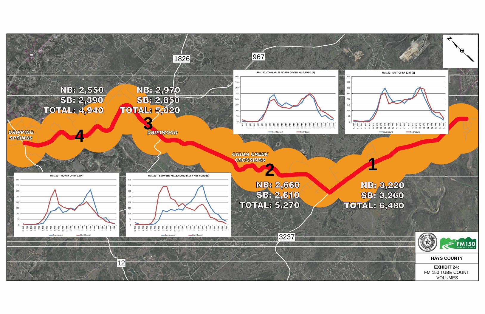
ONION CREEK CROSSINGS
£¤290
1826 967
12
3237
DRIPPING SPRINGS
DRIFTWOOD
HAYS COUNTY
EXHIBIT 24: FM 150 TUBE COUNT
VOLUMES
p
43
2 1
NB: 2,550 SB: 2,390TOTAL: 4,940
NB: 2,970 SB: 2,850TOTAL: 5,820
NB: 2,660 SB: 2,610TOTAL: 5,270
NB: 3,220 SB: 3,260TOTAL: 6,480
0
50
100
150
200
250
300
350
400
12 A
M
1 AM
2 AM
3 AM
4 AM
5 AM
6 AM
7 AM
8 AM
9 AM
10 A
M
11 A
M
12 P
M
1 PM
2 PM
3 PM
4 PM
5 PM
6 PM
7 PM
8 PM
9 PM
10 P
M
11 P
M
FM 150 - NORTH OF RR 12 (4)
Southbound Northbound
0
50
100
150
200
250
300
350
400
12 A
M
1 AM
2 AM
3 AM
4 AM
5 AM
6 AM
7 AM
8 AM
9 AM
10 A
M
11 A
M
12 P
M
1 PM
2 PM
3 PM
4 PM
5 PM
6 PM
7 PM
8 PM
9 PM
10 P
M
11 P
M
FM 150 - BETWEEN RR 1826 AND ELDER HILL ROAD (3)
Southbound Northbound
0
50
100
150
200
250
300
350
400
12 A
M
12 A
M
12 A
M
12 A
M
12 A
M
12 A
M
12 A
M
12 A
M
12 A
M
12 A
M
12 A
M
12 A
M
12 A
M
12 A
M
12 A
M
12 A
M
12 A
M
12 A
M
12 A
M
12 A
M
12 A
M
12 A
M
12 A
M
12 A
M
FM 150 - EAST OF RR 3237 (1)
Southbound Northbound
0
50
100
150
200
250
300
350
400
12 A
M
12 A
M
12 A
M
12 A
M
12 A
M
12 A
M
12 A
M
12 A
M
12 A
M
12 A
M
12 A
M
12 A
M
12 A
M
12 A
M
12 A
M
12 A
M
12 A
M
12 A
M
12 A
M
12 A
M
12 A
M
12 A
M
12 A
M
12 A
M
FM 150 - TWO MILES NORTH OF OLD KYLE ROAD (2)
Southbound Northbond

Existing Conditions
35
5.3 CRASH HISTORY
Crash data from January 2010 through June 2014 was collected and
assessed for the FM 150 corridor. The key purposes of assessing the
crash data are to identify:
Crash trends (i.e., crash severity, type, location, time of day)
Crash trends potentially attributed to the roadway geometry
Focus areas with higher crash frequencies/severity
In total, 98 crashes were reported on the corridor between January
2010 and June 2014. The majority of the reported crashes had no
injuries or possible injuries. Three fatal crashes were reported, all of
which were fixed object crashes, during dry, clear, daylight conditions.
None of the fatal crashes occurred at intersections. The locations of the
three fatal crashes are shown in Exhibit 25.
The graphs in Exhibit 26 and Exhibit 27 show the crashes by type versus
severity and by location versus severity, respectively. As seen in the
graph, the majority of crashes were classified as fixed object crashes. In
addition, the majority of crashes were non-intersection related and
occurred when the weather was clear. This data suggests a potential
influence of the roadway’s narrow shoulders, isolated or tight curves,
and non-recoverable sections of roadway.
Exhibit 28 maps all the crashes by type and Exhibit 29 maps all crashes
by severity. A copy of the crash data is provided in Section 7 of Volume
2.
Exhibit 25. Fatal Crash Locations (January 2010 – June 2014)

Existing Conditions
36
0
5
10
15
20
25
30
35
40
Fixed Object Motor Vehicle inTransport
Overturned Animal Other Object Other Non-Collision
Nu
mb
er o
f R
epo
rted
Cra
shes
Fatal
Incapacitating Injury
Non-incapacitating Injury
Possible Injury
Not Injured
Exhibit 26. Crashes by Type versus Severity
0
5
10
15
20
25
30
35
40
Non Intersection Intersection Intersection Related Driveway Access
Nu
mb
er o
f R
epo
rted
Cra
shes
Fatal
Incapacitating Injury
Non-incapacitating Injury
Possible Injury
Not Injured
Exhibit 27. Crashes by Location versus Severity

1826
967
12
150
£¤290
DRIPPINGSPRINGS
0 6,0003,000
Feetp
CRASH TYPEAnimal
Fixed Object
Overturned
Multi-Vehicle
Other non-collission
Other object
EXHIBIT 28 A. CRASH TYPEFM 150 CORRIDOR
HAYS COUNTY

7 multi-vehicle crashes
1626
2770
3237
150
MOUNTAINCITY
KYLE
0 6,0003,000
Feetp
CRASH TYPEAnimal
Fixed Object
Overturned
Multi-Vehicle
Other non-collission
Other object
EXHIBIT 28 B. CRASH TYPEFM 150 CORRIDOR
HAYS COUNTY

1826
967
12
150
£¤290
DRIPPINGSPRINGS
0 6,0003,000
Feetp
Crash SeverityFatal
Incapacitating Injury
Non-incapacitating Injury
Possible Injury
Not Injured
EXHIBIT 29A. CRASH SEVERITYFM 150 CORRIDOR
HAYS COUNTY

6 crashes with no injuries
1626
2770
3237
150
MOUNTAINCITY
KYLE
0 6,0003,000
Feetp
Crash SeverityFatal
Incapacitating Injury
Non-incapacitating Injury
Possible Injury
Not Injured
EXHIBIT 29B. CRASH SEVERITYFM 150 CORRIDOR
HAYS COUNTY
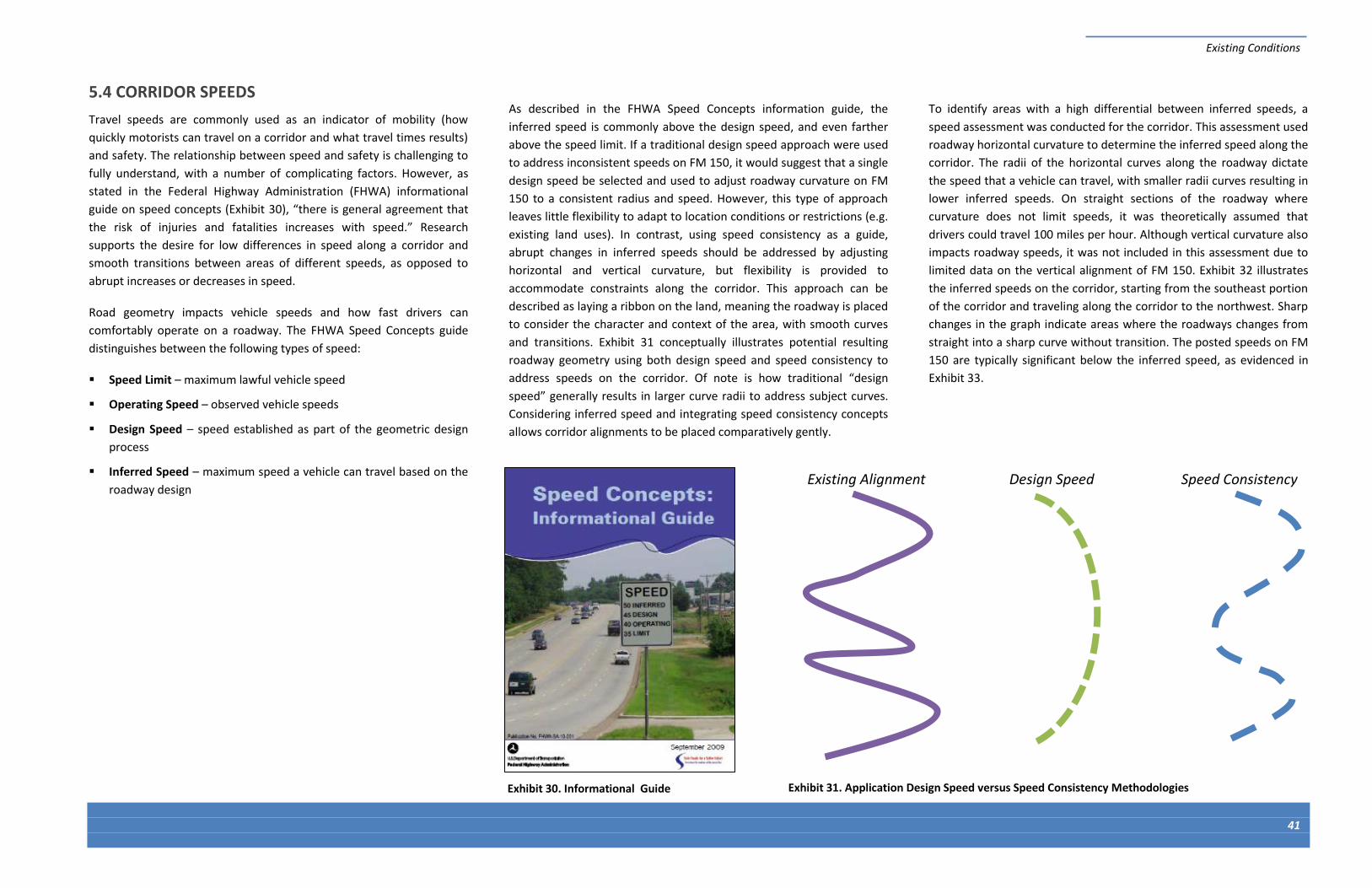
Existing Conditions
41
Existing Alignment Design Speed Speed Consistency
Exhibit 31. Application Design Speed versus Speed Consistency Methodologies
5.4 CORRIDOR SPEEDS
Travel speeds are commonly used as an indicator of mobility (how
quickly motorists can travel on a corridor and what travel times results)
and safety. The relationship between speed and safety is challenging to
fully understand, with a number of complicating factors. However, as
stated in the Federal Highway Administration (FHWA) informational
guide on speed concepts (Exhibit 30), “there is general agreement that
the risk of injuries and fatalities increases with speed.” Research
supports the desire for low differences in speed along a corridor and
smooth transitions between areas of different speeds, as opposed to
abrupt increases or decreases in speed.
Road geometry impacts vehicle speeds and how fast drivers can
comfortably operate on a roadway. The FHWA Speed Concepts guide
distinguishes between the following types of speed:
Speed Limit – maximum lawful vehicle speed
Operating Speed – observed vehicle speeds
Design Speed – speed established as part of the geometric design
process
Inferred Speed – maximum speed a vehicle can travel based on the
roadway design
As described in the FHWA Speed Concepts information guide, the
inferred speed is commonly above the design speed, and even farther
above the speed limit. If a traditional design speed approach were used
to address inconsistent speeds on FM 150, it would suggest that a single
design speed be selected and used to adjust roadway curvature on FM
150 to a consistent radius and speed. However, this type of approach
leaves little flexibility to adapt to location conditions or restrictions (e.g.
existing land uses). In contrast, using speed consistency as a guide,
abrupt changes in inferred speeds should be addressed by adjusting
horizontal and vertical curvature, but flexibility is provided to
accommodate constraints along the corridor. This approach can be
described as laying a ribbon on the land, meaning the roadway is placed
to consider the character and context of the area, with smooth curves
and transitions. Exhibit 31 conceptually illustrates potential resulting
roadway geometry using both design speed and speed consistency to
address speeds on the corridor. Of note is how traditional “design
speed” generally results in larger curve radii to address subject curves.
Considering inferred speed and integrating speed consistency concepts
allows corridor alignments to be placed comparatively gently.
To identify areas with a high differential between inferred speeds, a
speed assessment was conducted for the corridor. This assessment used
roadway horizontal curvature to determine the inferred speed along the
corridor. The radii of the horizontal curves along the roadway dictate
the speed that a vehicle can travel, with smaller radii curves resulting in
lower inferred speeds. On straight sections of the roadway where
curvature does not limit speeds, it was theoretically assumed that
drivers could travel 100 miles per hour. Although vertical curvature also
impacts roadway speeds, it was not included in this assessment due to
limited data on the vertical alignment of FM 150. Exhibit 32 illustrates
the inferred speeds on the corridor, starting from the southeast portion
of the corridor and traveling along the corridor to the northwest. Sharp
changes in the graph indicate areas where the roadways changes from
straight into a sharp curve without transition. The posted speeds on FM
150 are typically significant below the inferred speed, as evidenced in
Exhibit 33.
Exhibit 30. Informational Guide

Existing Conditions
42
Exhibit 32. Horizontal Curve Inferred Speed on Corridor
0
20
40
60
80
100
0 10,000 20,000 30,000 40,000 50,000 60,000 70,000 80,000 90,000
Infe
rred
Sp
eed
(m
ph
)
Location on Corridor (feet from southwest end of corridor)
Exhibit 33. Horizontal curve with a posted (advisory) speed of 45 miles per hour and inferred speed 52 miles per hour
Approximate Location
Double low-
water
crossings
Straight section
through
Driftwood

Existing Conditions
43
5.5 EXISTING CROSS SECTION
FM 150 is a two-lane roadway with minimal shoulder width throughout
the corridor. In general, lane widths are range between 11 and 12 feet,
and the shoulders are about one to two feet in width, with relatively
steep drop-offs in some areas. In general, the roadway does not provide
sufficient space for drivers to recover if they drift to the outer edge of
the roadway. Practically speaking, the roadway is relatively unforgiving
with regard to its ability to support drivers trying to recover from an
unexpected occurrence (e.g., animal crossing, another vehicle crossing
over). Exhibit 35 shows examples of the cross section along the corridor.
As shown in the exhibit, there is guardrail adjacent to the roadway at
some locations along the corridor.
Exhibit 35. Examples of Cross Section along FM 150 corridor
Exhibit 34. Diagram of Existing Cross Section

Page left intentionally blank

SECTION 6 Future Planning Framework

Page left intentionally blank

Future Planning Framework
47
6 FUTURE PLANNING FRAMEWORK
6.1 CONTEXT SENSITIVE SOLUTIONS APPROACH
Overview
CSS is a collaborative, interdisciplinary approach to developing study
solutions. A hallmark of CSS is actively involving stakeholders to develop
a transportation facility that fits its physical setting and preserves
scenic, aesthetic, historic, and environmental resources. The CSS
approach values community-based and supported solutions to address
a facility’s safety and mobility needs. A key component of CSS is open
and continuous communications between all parties beginning in the
earliest stages of concept development. This sets a foundation for
continuous and meaningful interaction at each step of the study
development staff from planning though construction of the completed
project. The FHWA, the American Association of State Highway and
Transportation Officials (AASHTO), the Transportation Research Board
(TRB), and TxDOT actively support and routinely promote CSS.
The FM 150 corridor is a critical component of the Hays County roadway
network. For many years, travel demands on this key linkage have been
relatively low, perhaps masking the extreme importance of the corridor
supporting regional and local travel needs. The significant growth in the
greater Travis County and Hays County region has not yet significantly
impacted travel along FM 150; however, projected growth in northern
and western Hays County will result in increasing travel demands. The
FM 150 corridor and surrounding area is a special place with unique
aesthetics, heritage, and historical elements The rural character and
natural habitat features must be thoughtfully protected and preserved
while recognizing corridor growth and demand is imminent, even if it is
not readily apparent today.
Hays County has initiated a unique study process to understand
community values, document and prioritize features and themes that
make the corridor special, and consider long-range concepts that reflect
the special nature and character of the FM 150 corridor and
surrounding area. This challenging and significant effort requires a
correspondingly unique community, agency, and stakeholder
involvement process to assure the completed FM 150 corridor plans
adequately incorporate community-based values, features, and themes.
The FM 150 study approach applies CSS principles in integrating
community input for corridor solutions that balance mobility and safety
objectives while enhancing the natural environment and preserve
community values.
Qualities and Characteristics of CSS
Thinking Beyond the Pavement: A National Workshop on Integrating
Highway Development With Communities and the Environment, held in
Maryland in 1998, established qualities and characteristics of the CSS
process. These characteristics emphasized that the process and
approach to developing community-based solutions was an important
as the range of solutions and products coming from planning efforts. In
considering the process and products of a successful project, the
workshop participants outlined the following “Qualities of Excellence” in
the project design elements (products):
The project satisfies the purpose and needs as agreed to by a full
range of stakeholders. This agreement is forged in the earliest phase
of the project and amended, as warranted, as the project develops.
The project is a safe facility for both the user and the community.
The project is in harmony with the community and preserves
environmental, scenic, aesthetic, historic, and natural resource
values of the area (i.e., exhibits context sensitive solutions).
The project exceeds the expectations of both designers and
stakeholders and achieves a level of excellence in people's minds.
The project involves efficient and effective use of the resources
(time, budget, community) of all involved parties.
The project is designed and built with minimal disruption to the
community.
The project is seen as having added lasting value to the community.
Exhibit 36. Project Develop Process and Associated Activities
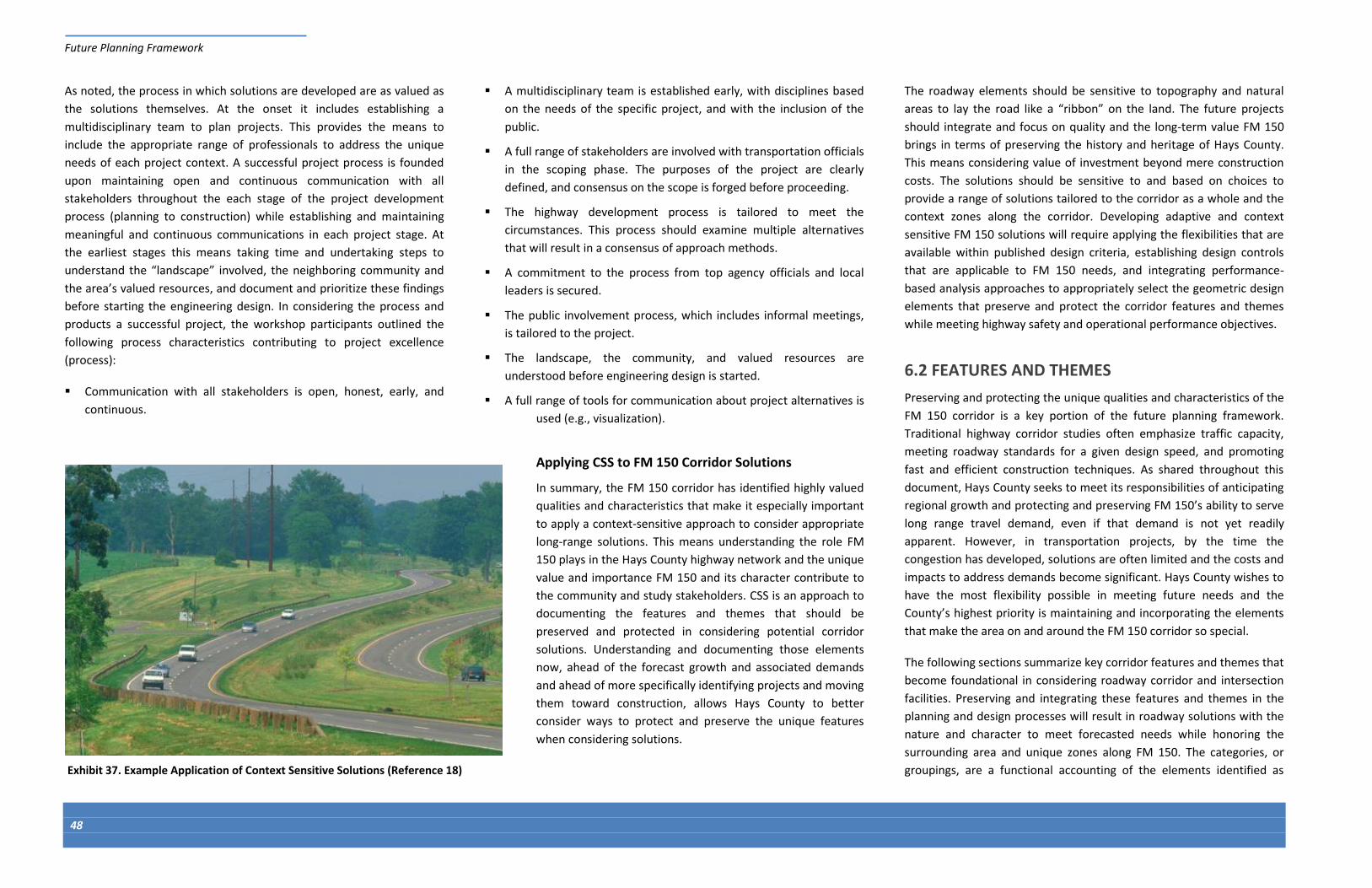
Future Planning Framework
48
As noted, the process in which solutions are developed are as valued as
the solutions themselves. At the onset it includes establishing a
multidisciplinary team to plan projects. This provides the means to
include the appropriate range of professionals to address the unique
needs of each project context. A successful project process is founded
upon maintaining open and continuous communication with all
stakeholders throughout the each stage of the project development
process (planning to construction) while establishing and maintaining
meaningful and continuous communications in each project stage. At
the earliest stages this means taking time and undertaking steps to
understand the “landscape” involved, the neighboring community and
the area’s valued resources, and document and prioritize these findings
before starting the engineering design. In considering the process and
products a successful project, the workshop participants outlined the
following process characteristics contributing to project excellence
(process):
Communication with all stakeholders is open, honest, early, and
continuous.
A multidisciplinary team is established early, with disciplines based
on the needs of the specific project, and with the inclusion of the
public.
A full range of stakeholders are involved with transportation officials
in the scoping phase. The purposes of the project are clearly
defined, and consensus on the scope is forged before proceeding.
The highway development process is tailored to meet the
circumstances. This process should examine multiple alternatives
that will result in a consensus of approach methods.
A commitment to the process from top agency officials and local
leaders is secured.
The public involvement process, which includes informal meetings,
is tailored to the project.
The landscape, the community, and valued resources are
understood before engineering design is started.
A full range of tools for communication about project alternatives is
used (e.g., visualization).
Applying CSS to FM 150 Corridor Solutions
In summary, the FM 150 corridor has identified highly valued
qualities and characteristics that make it especially important
to apply a context-sensitive approach to consider appropriate
long-range solutions. This means understanding the role FM
150 plays in the Hays County highway network and the unique
value and importance FM 150 and its character contribute to
the community and study stakeholders. CSS is an approach to
documenting the features and themes that should be
preserved and protected in considering potential corridor
solutions. Understanding and documenting those elements
now, ahead of the forecast growth and associated demands
and ahead of more specifically identifying projects and moving
them toward construction, allows Hays County to better
consider ways to protect and preserve the unique features
when considering solutions.
The roadway elements should be sensitive to topography and natural
areas to lay the road like a “ribbon” on the land. The future projects
should integrate and focus on quality and the long-term value FM 150
brings in terms of preserving the history and heritage of Hays County.
This means considering value of investment beyond mere construction
costs. The solutions should be sensitive to and based on choices to
provide a range of solutions tailored to the corridor as a whole and the
context zones along the corridor. Developing adaptive and context
sensitive FM 150 solutions will require applying the flexibilities that are
available within published design criteria, establishing design controls
that are applicable to FM 150 needs, and integrating performance-
based analysis approaches to appropriately select the geometric design
elements that preserve and protect the corridor features and themes
while meeting highway safety and operational performance objectives.
6.2 FEATURES AND THEMES
Preserving and protecting the unique qualities and characteristics of the
FM 150 corridor is a key portion of the future planning framework.
Traditional highway corridor studies often emphasize traffic capacity,
meeting roadway standards for a given design speed, and promoting
fast and efficient construction techniques. As shared throughout this
document, Hays County seeks to meet its responsibilities of anticipating
regional growth and protecting and preserving FM 150’s ability to serve
long range travel demand, even if that demand is not yet readily
apparent. However, in transportation projects, by the time the
congestion has developed, solutions are often limited and the costs and
impacts to address demands become significant. Hays County wishes to
have the most flexibility possible in meeting future needs and the
County’s highest priority is maintaining and incorporating the elements
that make the area on and around the FM 150 corridor so special.
The following sections summarize key corridor features and themes that
become foundational in considering roadway corridor and intersection
facilities. Preserving and integrating these features and themes in the
planning and design processes will result in roadway solutions with the
nature and character to meet forecasted needs while honoring the
surrounding area and unique zones along FM 150. The categories, or
groupings, are a functional accounting of the elements identified as Exhibit 37. Example Application of Context Sensitive Solutions (Reference 18)

Future Planning Framework
49
important to the community. The community has been clear that the
special nature of FM 150 should be passed on to future generations and
users, and the County agrees. The following topics are listed individually
however; the study team recognizes that the special nature of this part
of Hays County and FM 150 comes from the mix and interrelation of
unique and discrete elements that, in total, far exceed the value of any
one element.
History and Heritage
History and heritage comes in two forms: 1) officially designated
historical elements as recognized in environmental law and, 2) cultural
resources reflecting the history and evolution of an area over time.
While the latter may not have standing in environmental law, it reflects
stories and elements that help define a place or area and make that
place or area special none the less. Documenting and passing on the
history and heritage of a place has intrinsic value that might not be
captured by the strict definitions of environmental law. This portion of
Hays County includes historical land settlements of key members of
Texas history. Ranch land has passed from one family member to
another. The community of Driftwood is a physical example of a
different time; while remaining an active and current place as a
community center. The FM 150 corridor includes two recorded
archeological sites, two historical marker designations, and two
historical period cemeteries. The history and heritage of the area along
and surrounding FM 150 should be integrated into the future planning
framework.
Community Context
The areas of Kyle, Driftwood, and Dripping Springs define the formal
communities along the FM 150 corridor. However, re-emerging
development in Hays City and the residential enclaves along Elder Hill
and Darden Hill Roads reflect unique communities and a populace who
have chosen to live or remain in this part of Hays County. There is a
sense of pride and ownership in the area. New development is
occurring along RM 12 near the FM 150 intersection. Wineries,
breweries, retail, and restaurants make this part of Hays County a
tourist destination. In total, the community context reflects the rural
character symbolized by larger parcels, ranches, and a desire to
maintain the look and feel of the area. There is significant pride in the
history and heritage and natural qualities surrounding FM 150. The
qualities so valued by the community will help guide the nature and
character of eventual roadway solutions.
Land Uses
One would expect continued growth in Kyle resulting in growing travel
demand in the south section of the FM 150 study area. The
developments will likely include more public and private access points
on FM 150 along with generally increased turning volumes at access
points. This means the transition from the rural character of northern
and western sections of FM 150 will require special detail to serve the
adjacent land uses. This could influence intersection and median
configurations along with turn lanes and intersection traffic control
choices. The types of roadway and intersection needs in the South
Section may vary from other parts of the corridor.
Hays City is experiencing a re-emergence as a meeting place. Private
investment in retail and commercial (restaurant) businesses has made
this location a place of activity once again. As noted throughout the
study during the CAP process and general public meetings, establishing
route continuity would be an objective in Hays City so those traveling
along FM 150 remain on their route versus “exiting” to the right to go
northwest or making the left turn at Old Kyle Road (FM 3237) to travel
southeast. There are a variety of potential alignment and intersection
treatments for the intersection. Preserving access and circulation to
support existing businesses and potential new land uses will be a focus
in future roadway and intersection evaluations.
Much has been written about the community pride and valuation of the
historical elements of Driftwood. This study has documented a “Z”
movement of north-south travel demand in the morning and evening
peak periods between Elder Hill Road and RR 1826. This demand means
north-south traffic is overlaid upon FM 150 and puts pressure on the FM
150/Elder Hill Road intersection. That intersection is in the heart of
downtown Driftwood with close proximity to the beloved former gas
station/general store and across from the community center complex.
The “Z” movement increases the southbound left turning traffic from
FM 1826 to FM 150 and the overall effect of the north-south demand is
to add pressure on FM 150 in Driftwood. Future evaluations in this
study area will require special attention on how to serve existing and
forecast demand while protecting the qualities and characteristics that
make Driftwood so highly valued by the community. More broadly and
considering Driftwood, FM 150 solutions may include reduced speeds
through downtown and roadway transition features that clearly depict
the arrival to and departure from Driftwood’s core. A slower travel
speed for this short section of FM 150 would result in a marginally
longer overall travel time between Dripping Springs and Kyle while
contributing to preserving this special place.
Residential development on RM 12 north of the FM 150 intersection is
symbolic of the continued growth in and around Kyle. The brewery on
FM 150 near the RM 12 intersection may be the leading indicator of
more development near the FM 150/RM 12 intersection. There have
been early discussions about localized land development adjacent to
the intersection, across from the Phillips Cemetery. Hays County has
expressed interest in not precluding a possible roadway connection
from FM 150 at RM 12 to US 290. This potential connection is not part
of this FM 150 evaluation. Increased traffic demand is forecast for the
RM 12 intersection. Future FM 150 roadway and intersection concepts
must consider and avoid affecting the cemetery, not preclude a
potential roadway extension to US 290, and be sensitive to future
development near and around the FM 150/RM 12 intersection.
In addition to these community areas, there are other land uses such as
commercial businesses, a church, and a winery. These land uses result
in various levels of traffic demand that will influence how access to and
from FM 150 will be provided. The land uses could influence median
and turn lane designs and other roadway features needed to promote
safe access and circulation. These and other individual locations will be
considered and integrated in future study efforts.
Environments/Needs
The rural qualities around FM 150 create open lands that have
remained virtually untouched in some locations but generally natural in

Future Planning Framework
50
most areas. The natural character is prized by the community and to the
extent FM 150 has any effect on private lands along the corridor, future
project activities will attempt to avoid and minimize physical impacts to
surrounding areas. From an environmental planning point of view, there
are a number of regulatory areas that will need to be assessed and
documented to attain appropriate State and National environmental
approvals. These generally relate to surface and groundwater topics
such as the Onion and Rocky Branch creek crossings and the Edwards
Aquifer contributing zone. Other habitat investigations will consider
rare and listed species.
Other environmental topics include assessing historical properties. For
example, Michaelis Ranch is listed on the National Register of Historic
Places and future study efforts will focus on avoiding impacts to this
historical treasure. In addition, there are historical properties or
elements along the corridor or in the area that are not on the National
Register of Historical Places. The community has been clear in the
important value of these features. Future study efforts will consider
listed and non-listed historical features while developing FM 150
corridor solutions.

Future Planning Framework
51
Current
Employment
2035 Plan Projection
2040 Plan Projection
Current
Population
2035 Plan Projection
2040 Plan Projection
0
100,000
200,000
300,000
400,000
500,000
600,000
700,000
2015 2020 2025 2030 2035 2040
Exhibit 38. Population and Employment Projections (Source: HCTP)
6.3 FORECAST TRAFFIC
Since the 2013 HCTP was adopted, Capital Area Metropolitan Planning
Organization (CAMPO) population and employment projections have
increased beyond original projections. Hays County is currently the third
fastest growing county in the United States and Kyle is the fifth fastest
growing city in Texas. The 2013 HCTP considered a 2035 scenario. The
following describes how updates to the regional forecasts for 2040
differ from the 2035 forecast of the 2013 HCTP.
Exhibit 38 shows the projections from the 2040 forecast compared to
the previous 2035 forecast. The 2040 forecast projects population will
more than double by 2030, 5 years earlier than previously projected,
and by 2040, just 24 years from now, the population of Hays County is
projected to be more than triple what it is now. Projections have also
increased for employment since the 2035 forecast, as the 2040 scenario
projects employment will more than double by 2030. As expected with
the increased residential and employment populations, the County
must begin to prepare for infrastructure improvements necessary to
handle the increased traffic demands. Exhibit 39 shows areas of
anticipated growth in terms of changes in population and employment
densities. Changes are not expected to be evenly dispersed across the
County, but rather concentrated in urban centers along I-35 and further
west, such as Dripping Springs. Rural areas are anticipated to remain
rural; however, roads through these rural areas will need to
accommodate efficient travel between population and employment
centers. Changes in population are concentrated in San Marcos, Kyle,
and Buda and the roads serving these areas are expected to become
more congested if no improvements are made ahead of time.
The HCTP documents and memorializes the County’s philosophy of
focused improvements and embraces a tiered approach to growth:
Improve the safety and efficiency of all roadways when
opportunities arise;
add capacity to certain, key roadways; and,
add new roadways only when needed.
This Corridor Features and Themes Report
documents a corridor planning approach that
seeks to protect and preserve heritage and
character and add new roadways only when
needed. Hays County values environmental
features and seeks to proactively plan for the
future growth. This study effort is an example
of these values at work and the County’s desire
to find creative approaches for community
solutions. The county recognizes the existing
infrastructure cannot safely and efficiently
accommodate the projected growth; therefore,
changes to FM 150 will be necessary to meet
forecast demand. While these changes can be
accommodated, care must be taken to find
corridor solutions that preserve the character
of the FM 150 corridor, while also accepting
that changes must be made to address
impending travel demand. The HCTP identifies
a future network of major thoroughfares to
serve anticipated future capacity needs. As
seen in Exhibit 1, FM 150 is included along with
several other roads in the area as a corridor
where lanes could be added.
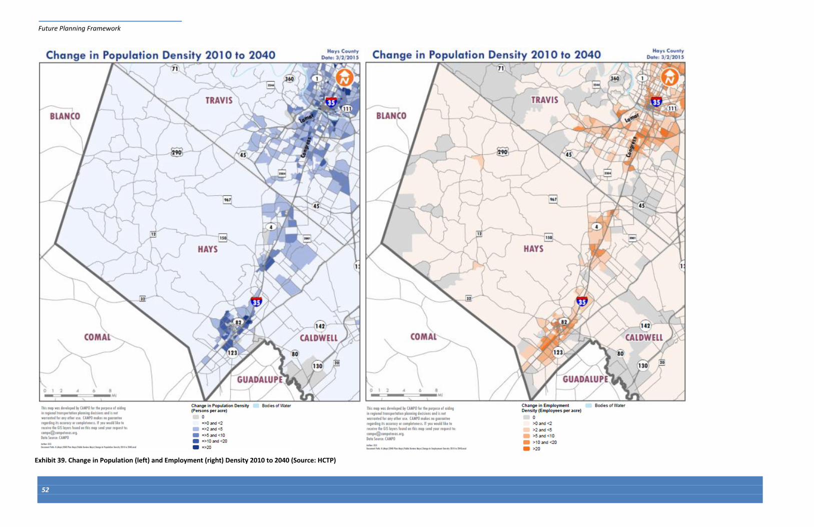
Future Planning Framework
52
Exhibit 39. Change in Population (left) and Employment (right) Density 2010 to 2040 (Source: HCTP)

SECTION 7 Continuum of Improvements

Page left intentionally blank

Continuum of Improvements
55
Exhibit 41. Near-, Mid-, and Long-Term Improvements
7 CONTINUUM OF IMPROVEMENTS The intent of this Corridor Features and Themes Report is to develop a
continuum of improvements. This means considering a range of near-,
mid-, and long-term improvements. As illustrated in Exhibit 40, the
County is early in the process and these early planning activities pre-
date the development of projects. Concepts that move forward from
this step will enter another planning process with multiple opportunities
for public involvement, alternative considerations, and refinement.
The following steps were taken throughout the study to develop
potential future improvements:
Established study “context zones”
Confirmed the Driftwood community and double-low water
crossings had special value
Considered existing corridors per the Hays County Transportation
Plan (HCTP)
Considered new routes per the HCTP
Identified a range of potential FM 150 corridor concepts
Developing a continuum of improvements allows the County to make
necessary near-term improvements to FM 150 focused on enhancing
the corridor’s safety performance, while planning for future growth.
During this first step, opportunities to enhance the safety performance
of the existing FM 150 roadway have been identified, such as widening
shoulders and increasing sight-distance around curves and near
intersections. These improvements would likely be completed within
the existing right-of-way with very
little, but beneficial, changes to the
roadway.
In addition, mid-term improvements
have been identified to also enhance
safety performance while transitioning
to the long-term layout for the
corridor. These improvements include
curve widening or curve smoothing to
address speed inconsistences, which
would result in smoother transitions
along the corridor.
As the long-term improvements are
identified, the mid-term improvements would be designed to ensure
that the long-term improvements are easily implementable and would
limit disruption as much as possible by creating transitions to potential
new alignments. By laying out the long-term improvements at this point
in the process, the County will be able to plan for phasing projects to
meet the increased population and traffic volumes along the FM 150
corridor, rather than waiting until the capacity of the existing roadway is
inadequate and opportunities are more limited. This approach provides
flexibility and allows the community to proactively plan for the future.
Exhibit 41 illustrates the continuum of potential improvements for the
corridor, which are further explored in the following sections.
7.1 FUTURE ALIGNMENT AND CONCEPTS
The following sub-sections introduce potential future alignments and
concepts for the corridor, broken up into segments based on the
context zones. For each segment, a description of the roadway and key
characteristics is provided, as well as a range of near-, mid-, and long-
term improvements. The intention is to provide a range of options that
provide enhanced safety performance and capacity for projected future
volumes. For some portions of the corridor, study of a potential future
bypass route is proposed to provide capacity off the existing alignment.
The concept for this study was developed based on feedback from the
CAP and the community about the importance of preserving the existing
Exhibit 40. Project Timeline

Continuum of Improvements
56
alignment through the double water crossings and Driftwood, where it
is infeasible to expand the roadway to four-lanes. The potential for a
future bypass route(s) will be studied in a process independent from
this work and will be subject to future planning and public review.
The range of improvements is described more generally in the
following section describing potential improvements for each section of
the corridor.
Range of Improvements
Based on the review of the corridor and input from the public, several
potential improvements were developed that are applicable to
significant sections of the corridor, as opposed to site-specific. These
improvements present a range of options from lower cost, smaller
impact improvements that could be conducted in the near-term to
larger cost, more significant improvements that would be conducted in
the long-term.
Safety Section (near-term)
As described in the “Existing Conditions” section, the shoulders on FM
150 are minimal in width and typically one to two feet along the
corridor. There are several locations where the side of the roadway
drops off quickly and steeply, providing little opportunity for drivers to
recover if they drift toward the roadway edge. To enhance the safety
performance of the roadway and provide more space for vehicles to
recover, the shoulders could be widened. We anticipate this
improvement would also reduce run off the road crashes. Exhibit 42
shows an example of the potential corridor cross section, with the
paved shoulders widened to four feet followed by a four foot reinforced
grass or gravel shoulder. Exhibit 43 shows an image from RM 12, which
provides an example of the near term section that could be
implemented on FM 150.
Intersection Enhancements (near- to mid-term)
Potential near- to mid-term improvements to enhance intersections
along the corridor include:
Improving delineation: enhance the visibility of the intersection and
provide visual cues to inform drivers of the presence of the
intersection and what maneuvers are allowed. Opportunities to
improve delineation include installing street lighting, enhancing
pavement marking and signing, and adjusting intersection
approaches to improve sight distance to and from FM 150.
Considering alternative traffic control: a roundabout can provide
increased capacity, act as a traffic calming measure, and serve as a
gateway treatment to signal to drivers that they are entering a
portion of the corridor that is unique. A traffic signal can also
provide increased capacity.
Enhancing sight-distance: look for opportunities to approach
intersection sight-distance, such as addressing vertical curvature,
realigning the intersection approaches, or modifying landscaping or
other features that limit sight.
Intersection Improvements: look for opportunities to add left or
right turn lanes to provide refuge for turning vehicles.
The public intersections along the corridor were assessed from an
operational and safety perspective to identify potential improvements,
with the intent of enhancing the operational and safety performance
while considering the character and context of the area. Specific
improvements are discussed for each section of the corridor.
Exhibit 43. Safety Section Example from RM 12 Exhibit 42. Safety Section Cross-Section
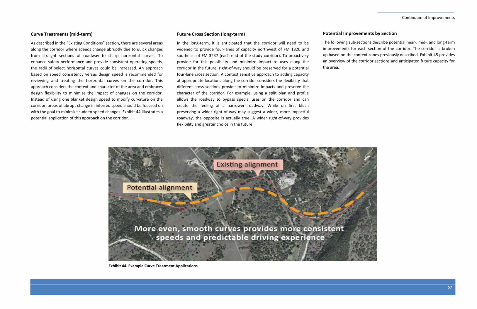
Continuum of Improvements
57
Exhibit 44. Example Curve Treatment Applications
Curve Treatments (mid-term)
As described in the “Existing Conditions” section, there are several areas
along the corridor where speeds change abruptly due to quick changes
from straight sections of roadway to sharp horizontal curves. To
enhance safety performance and provide consistent operating speeds,
the radii of select horizontal curves could be increased. An approach
based on speed consistency versus design speed is recommended for
reviewing and treating the horizontal curves on the corridor. This
approach considers the context and character of the area and embraces
design flexibility to minimize the impact of changes on the corridor.
Instead of using one blanket design speed to modify curvature on the
corridor, areas of abrupt change in inferred speed should be focused on
with the goal to minimize sudden speed changes. Exhibit 44 illustrates a
potential application of this approach on the corridor.
Future Cross Section (long-term)
In the long-term, it is anticipated that the corridor will need to be
widened to provide four-lanes of capacity northwest of FM 1826 and
southeast of FM 3237 (each end of the study corridor). To proactively
provide for this possibility and minimize impact to uses along the
corridor in the future, right-of-way should be preserved for a potential
four-lane cross section. A context sensitive approach to adding capacity
at appropriate locations along the corridor considers the flexibility that
different cross sections provide to minimize impacts and preserve the
character of the corridor. For example, using a split plan and profile
allows the roadway to bypass special uses on the corridor and can
create the feeling of a narrower roadway. While on first blush
preserving a wider right-of-way may suggest a wider, more impactful
roadway, the opposite is actually true. A wider right-of-way provides
flexibility and greater choice in the future.
Potential Improvements by Section
The following sub-sections describe potential near-, mid-, and long-term
improvements for each section of the corridor. The corridor is broken
up based on the context zones previously described. Exhibit 45 provides
an overview of the corridor sections and anticipated future capacity for
the area.

ONION CREEK CROSSINGS
£¤290
POTENTIAL BYPASS STUDY AREA
DRIFTWOOD
1826
2 lanes capacity
R.O.W. for up to 4 lanes of
capacity
DRIPPING SPRINGS
R.O.W. for up to 4 lanes of
capacity
EXISTING ALIGNMENT
1826 967
1826
12
3237
HAYS COUNTY
EXHIBIT 45: POTENTIAL FUTURE CAPACITY
ON FM 150 CORRIDOR
p

Continuum of Improvements
59
South Section (from Arroyo Ranch to FM 3237)
The south section of the study corridor provides a transition from Kyle
to the rest of the FM 150 corridor, which is more rural in character.
There are a variety of larger housing developments and single-family
homes along the corridor, including the Michaelis Ranch, a National
Register of Historic Places property. This section of the corridor is
generally straighter than the rest of the corridor, with a few larger
horizontal curves. Potential improvements include:
Shoulder widening (near-term): widen the existing shoulders to 4-8
feet, including paved or reinforced grass/gravel.
Curve smoothing (mid-term): modify the three horizontal curves in
this section of roadway to provide smoother transitions.
Four-lane cross section (long-term): as needed, widen the roadway
to two-lanes in each direction, considering the flexibility to split the
corridor plan and profile.
Exhibit 47 shows an image of the existing
roadway cross section while Exhibit 48
illustrates conceptual future improvements.
Exhibit 47. Existing Roadway (traveling westbound on FM 150)
Exhibit 48. Conceptual Improvements for South Section
Exhibit 46. South Section (from Arroyo Ranch to RM 3237)

Continuum of Improvements
60
Exhibit 49. FM 150 at RM 3237
FM 150 at FM 3237
The FM 150/FM 3237 intersection provides a transition from the south
section of the corridor to the rural highway zone. The intersection is
currently a community zone, with several commercial uses adjacent to
the intersection, and this area is expected to grow in the future. FM 150
makes a ninety degree turn at this intersection so users must turn to
stay on FM 150 (vehicles coming from the southeast continuing straight
are led to FM 3237). This violates driver expectation, which assumes if
you make no changes to your travel path you remain on the designated
roadway. Potential improvements include:
Re-aligning the intersection (mid-term): to provide route continuity
on FM 150, so vehicles do not have to turn to stay on FM 150.
Changing the intersection form (long-term): converting the
intersection to a signal or roundabout to provide additional
capacity. A roundabout would also act as a gateway treatment to
alert drivers they are entering the section of FM 150 with a rural
highway character.
Adding multimodal facilities: adding bike
lanes, sidewalks, or paths as the community
center around the intersection develops.
Exhibit 50 provides an image of the existing
intersection while Exhibit 51 illustrates a concept
for potential future improvements.
Right turn to stay on FM 150
Exhibit 50. Existing Roadway (westbound approach on FM 150)
Exhibit 51. Conceptual Future Improvements
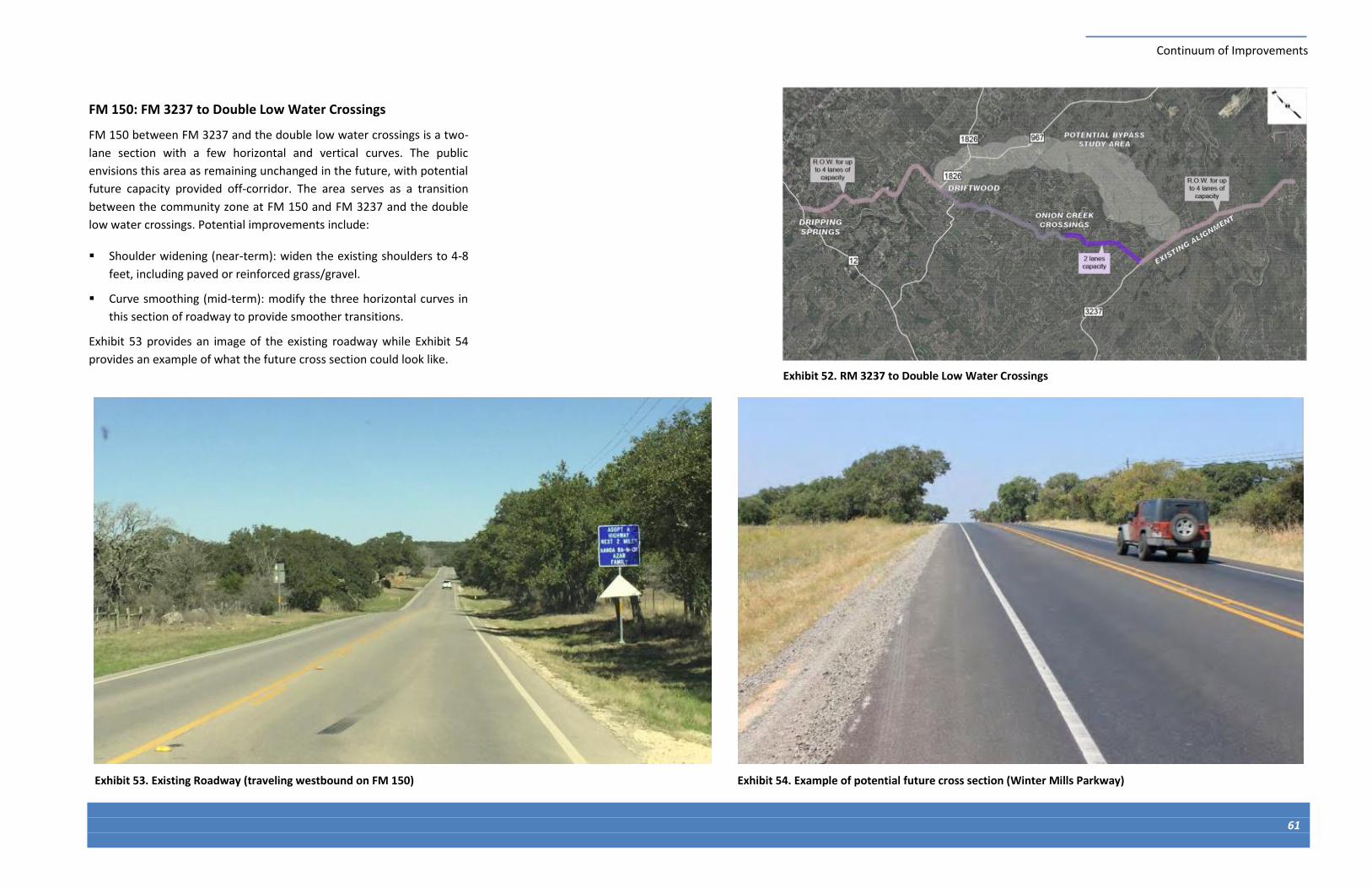
Continuum of Improvements
61
FM 150: FM 3237 to Double Low Water Crossings
FM 150 between FM 3237 and the double low water crossings is a two-
lane section with a few horizontal and vertical curves. The public
envisions this area as remaining unchanged in the future, with potential
future capacity provided off-corridor. The area serves as a transition
between the community zone at FM 150 and FM 3237 and the double
low water crossings. Potential improvements include:
Shoulder widening (near-term): widen the existing shoulders to 4-8
feet, including paved or reinforced grass/gravel.
Curve smoothing (mid-term): modify the three horizontal curves in
this section of roadway to provide smoother transitions.
Exhibit 53 provides an image of the existing roadway while Exhibit 54
provides an example of what the future cross section could look like.
Exhibit 54. Example of potential future cross section (Winter Mills Parkway) Exhibit 53. Existing Roadway (traveling westbound on FM 150)
Exhibit 52. RM 3237 to Double Low Water Crossings

Continuum of Improvements
62
Exhibit 55. FM 150 at the Double Low Water Crossings
Double Low Water Crossings
The double low water crossings on FM 150 are an area of special
significance due to the natural beauty of the area and historical
significance it holds for the community. The vertical curvature of the
roadway dips through this section at each low water crossing, creating a
significant change in the inferred speed from the roadway sections on
either side of the crossings. The low water crossings flood during heavy
rain events, presenting an opportunity to improve the reliability of the
corridor. Potential improvements include:
Shoulder widening (near-term): widen the existing shoulders to 4-8
feet, including paved or reinforced grass/gravel.
Curve smoothing (mid-term): modify the horizontal and vertical
curves in this section of roadway to provide smoother transitions
and less drastic changes in inferred speed.
Upgrading the crossing (long-term): modify
the crossing to provide a more elevated
crossing that minimizes the potential of
flooding while considering the character of
the area and importance of the crossings.
Exhibit 56 provides an image of the existing
corridor through one of the low water crossings
while Exhibit 57 provides a concept that raises
the existing roadway surface to reduce the
number of closures caused by flooding.
Exhibit 57. Conceptual Future Improvements Exhibit 56. Existing Roadway (traveling westbound on FM 150)

Continuum of Improvements
63
Exhibit 58. Driftwood Community Zone
FM 150: Driftwood and FM 1826
The portion of FM 150 around Driftwood is a special area due to the
historical significance of the area and the existing community use. The
roadway is constrained in this area because of the close proximity of
land uses to the roadway. This section of the roadway is intended to
remain as two through lanes, with additional capacity (if needed)
provided off the existing corridor. Traffic data collected on the corridor
revealed a “Z” movement of traffic, where vehicles traveling north-
south between Elder Hill Road and FM 1826 use a small portion of FM
150 during morning and evening commutes. Potential improvements
include:
Shoulder widening (near-term): widen the existing shoulders to 4-8
feet, including paved or reinforced grass/gravel.
Curve smoothing (mid-term): modify the horizontal curves in this
section of roadway to provide smoother transitions.
Adding multimodal facilities (mid-term): adding bike lanes,
sidewalks, or paths to serve the Driftwood community center.
Re-aligning FM 1826 (mid-term): to provide a
direct connection across FM 150 and
eliminate the “Z” movement of vehicles on
FM 150.
Changing the intersection form (long-term):
converting the FM 150/FM 1826 and FM
150/Elder Hill Road intersections to a signal or
roundabout to provide additional capacity. A
roundabout would also act as a gateway
treatment to alert drivers they are entering
the Driftwood community area.
Exhibit 59 provides an image of the existing
roadway through Driftwood while Exhibit 60
illustrates potential future improvements.
Exhibit 60. Conceptual Future Improvements Exhibit 59. Existing Roadway (traveling westbound on FM 150)
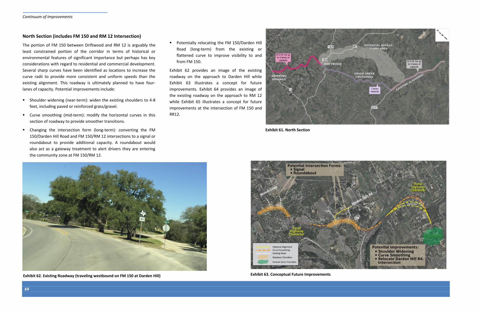
Continuum of Improvements
64
Exhibit 61. North Section
North Section (includes FM 150 and RM 12 Intersection)
The portion of FM 150 between Driftwood and RM 12 is arguably the
least constrained portion of the corridor in terms of historical or
environmental features of significant importance but perhaps has key
considerations with regard to residential and commercial development.
Several sharp curves have been identified as locations to increase the
curve radii to provide more consistent and uniform speeds than the
existing alignment. This roadway is ultimately planned to have four-
lanes of capacity. Potential improvements include:
Shoulder widening (near-term): widen the existing shoulders to 4-8
feet, including paved or reinforced grass/gravel.
Curve smoothing (mid-term): modify the horizontal curves in this
section of roadway to provide smoother transitions.
Changing the intersection form (long-term): converting the FM
150/Darden Hill Road and FM 150/RM 12 intersections to a signal or
roundabout to provide additional capacity. A roundabout would
also act as a gateway treatment to alert drivers they are entering
the community zone at FM 150/RM 12.
Potentially relocating the FM 150/Darden Hill
Road (long-term) from the existing or
flattened curve to improve visibility to and
from FM 150.
Exhibit 62 provides an image of the existing
roadway on the approach to Darden Hill while
Exhibit 63 illustrates a concept for future
improvements. Exhibit 64 provides an image of
the existing roadway on the approach to RM 12
while Exhibit 65 illustrates a concept for future
improvements at the intersection of FM 150 and
RR12.
Exhibit 63. Conceptual Future Improvements Exhibit 62. Existing Roadway (traveling westbound on FM 150 at Darden Hill)

Continuum of Improvements
65
Exhibit 65. Conceptual Future Improvements Exhibit 64. Existing Roadway (traveling westbound on FM 150 at RM 12)

Continuum of Improvements
66
Future Study
Throughout this stage of the process, the special importance of the
Onion Creek double low water crossings and Driftwood community
center has been confirmed through meetings with the CAP and public.
The ability to widen the roadway through these areas is constrained by
the topography of the low water crossings and proximity of
development in Driftwood to the corridor. Therefore, other
opportunities to provide capacity between FM 150/FM 3237 and FM
150/FM 1826 were explored at a high-level.
As the study progresses, the County and the study team will continue to
consider potential bypasses and alternative alignments. This preliminary
assessment would be followed-up by conducting specific project studies
and/or planning processes that include customized community
outreach and coordination for each location or study area. This effort
would verify bypass options are feasible and are the right solutions for
the County’s projected growth, while integrating into the unique
contexts of each project or study area. Given the possibility of a bypass,
there is an opportunity to further develop the partnership between the
County and TxDOT and consider whether this portion the existing
roadway should stay in TxDOT control or be delegated to the County for
local control and management.
Exhibit 66 shows the potential bypass study area on the north side of
the corridor. This concept and other options will continue to be
developed and discussed in future project studies. The potential bypass,
as seen in Exhibit 66, is a new roadway that connects FM 150 south of
the intersection with FM 3237 to RM 967. This bypass would route
traffic around Driftwood, the double low water crossings, and the other
context zones in the Driftwood Heritage Corridor. While this is the only
potential bypass identified at this stage in the process, other bypasses
will continue to be evaluated to provide the most options for the
County and community.
Exhibit 66. Future Study Area

SECTION 8 Next Steps

Page left intentionally blank
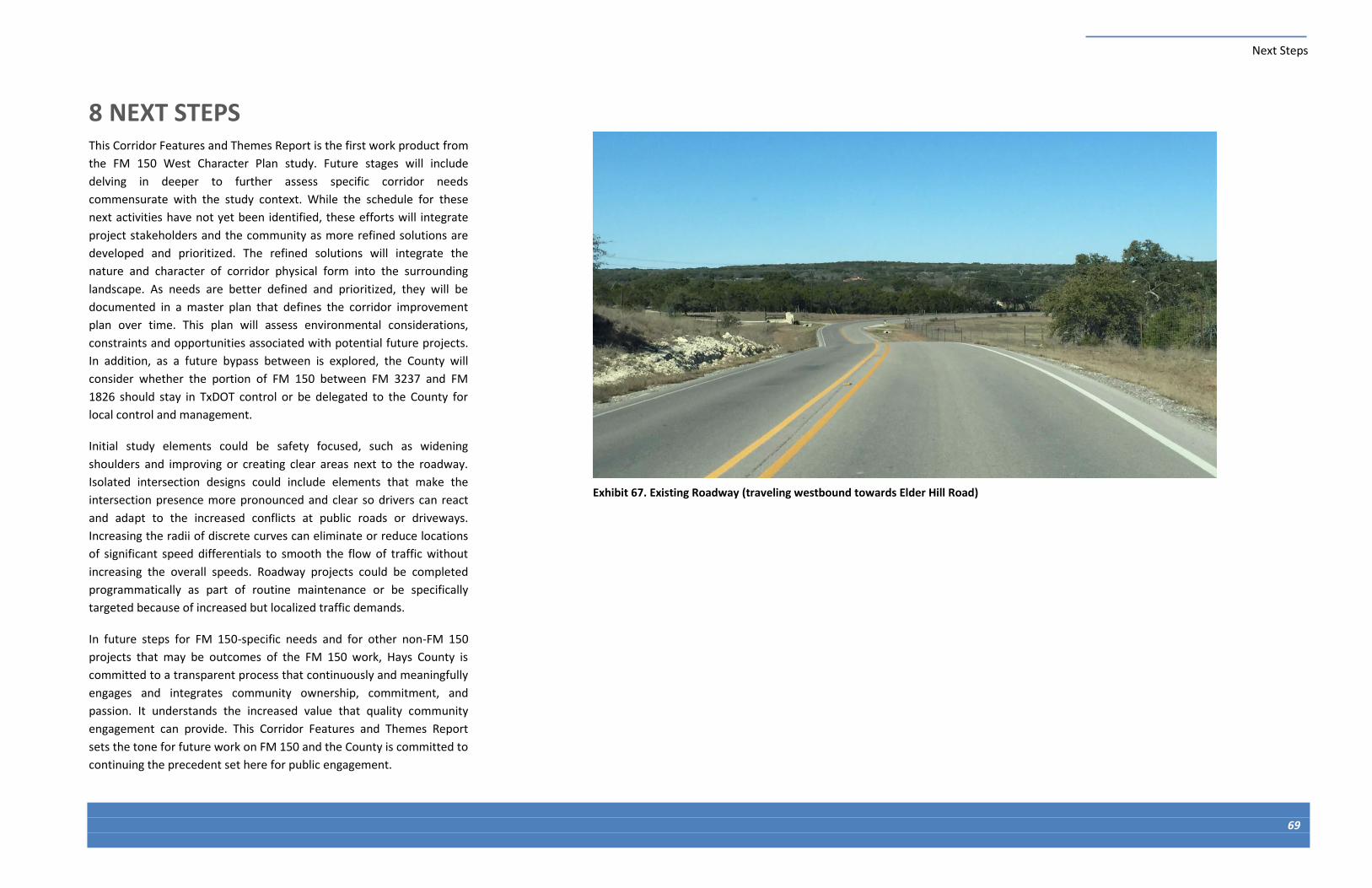
Next Steps
69
8 NEXT STEPS This Corridor Features and Themes Report is the first work product from
the FM 150 West Character Plan study. Future stages will include
delving in deeper to further assess specific corridor needs
commensurate with the study context. While the schedule for these
next activities have not yet been identified, these efforts will integrate
project stakeholders and the community as more refined solutions are
developed and prioritized. The refined solutions will integrate the
nature and character of corridor physical form into the surrounding
landscape. As needs are better defined and prioritized, they will be
documented in a master plan that defines the corridor improvement
plan over time. This plan will assess environmental considerations,
constraints and opportunities associated with potential future projects.
In addition, as a future bypass between is explored, the County will
consider whether the portion of FM 150 between FM 3237 and FM
1826 should stay in TxDOT control or be delegated to the County for
local control and management.
Initial study elements could be safety focused, such as widening
shoulders and improving or creating clear areas next to the roadway.
Isolated intersection designs could include elements that make the
intersection presence more pronounced and clear so drivers can react
and adapt to the increased conflicts at public roads or driveways.
Increasing the radii of discrete curves can eliminate or reduce locations
of significant speed differentials to smooth the flow of traffic without
increasing the overall speeds. Roadway projects could be completed
programmatically as part of routine maintenance or be specifically
targeted because of increased but localized traffic demands.
In future steps for FM 150-specific needs and for other non-FM 150
projects that may be outcomes of the FM 150 work, Hays County is
committed to a transparent process that continuously and meaningfully
engages and integrates community ownership, commitment, and
passion. It understands the increased value that quality community
engagement can provide. This Corridor Features and Themes Report
sets the tone for future work on FM 150 and the County is committed to
continuing the precedent set here for public engagement.
Exhibit 67. Existing Roadway (traveling westbound towards Elder Hill Road)

Page left intentionally blank

SECTION 9 References

Page left intentionally blank

References
73
9 REFERENCES 1. Parsons Brinckerhoff. Hays County Transportation Plan.
Prepared for Hays County. April 2013.
2. Texas Parks and Wildlife Department (TPWD). 2016. Ecologically
significant stream segments. Planning Data by Region K.
http://tpwd.texas.gov/landwater/water/conservation/water_re
sources/water_quantity/sigsegs/regionk.phtml, accessed
February 4, 2016.
3. Texas Water Development Board (TWDB). 2015. Groundwater
Database.
http://www.twdb.texas.gov/groundwater/data/gwdbrpt.asp,
accessed January 20, 2016
4. Ryder, Paul D. 1996. Ground Water Atlas of the United States;
Oklahoma, Texas. HA 730-E.
5. http:// pubs.usgs.gov/ha/ha730/ch_e/E-text8.html.Griffith,
Glenn., Sandy Bryce, James Omernik, and Anne Rogers. 2007.
Ecoregions of Texas. Edwards Plateau.
6. Texas Parks and Wildlife Department (TPWD). 2014. Ecological
Mapping Systems of Texas.
https://tpwd.texas.gov/gis/data/downloads#EMS-T.
7. McMahan, C.A., R.G. Frye, and K.L. Brown. 1984. The Vegetation
Types of Texas Including Cropland. Texas Parks and Wildlife
Department PWD Bulletin 7000-120, September 1984.
8. Davis, W.B., and D.J. Schmidly. 1997. The Mammals of Texas On-
line Edition. Texas Tech University.
http://www.nsrl.ttu.edu/tmot1/distribu.htm, accessed January
20, 2016.
9. Dixon, James R. 2013. Amphibians & Reptiles of Texas. Texas
A&M University at College Station, Texas.
10. Birds of the Edwards Plateau: a field checklist. 2008. TPWD
Natural Resources Program, Austin, Texas.
11. City of Austin. Water Quality Protection Land.
http://www.austintexas.gov/department/water-quality-
protection-land, accessed February 2, 2016.
12. Collins, M.B. 1995 Forty Years of Archeology in Central Texas.
Bulletin of the Texas Archeological Society 66:361-400.fcasarez.
13. Texas Historical Commission (THC). 2015. Texas Historical Sites
Atlas. https://atlas.thc.state.tx.us/, accessed January 20, 2016.
14. Rogers, Minnie L. 1970. Driftwood Heritage: The History of
Driftwood, Texas. Driftwood Ladies-Aid. Capital Printing
Company. Austin, Texas.
15. Philips Cemetery Association. 2015. Philips Cemetery: About Us.
http://www.phillipscemetery.com/#!about/cjn9, accessed
February 4, 2016.
16. Hays County Historical Commission. 2016. Hays County
Cemeteries.
http://www.hayshistoricalcommission.com/cemeteries/
Cemeteries-Main.php, accessed January 20, 2016.
17. Bella Nido LLC Bed and Breakfast.
www.bellanido.com/index.html, accessed March 23, 2016.
18. Federal Highway Administration (FHWA). Welcome to CSS.
http://contextsensitivesolutions.org/, accessed October 10,
2014.

Page left intentionally blank