The First 200
52
I MoDOT REF TE715 . M8A21 1966 JUL 20 1967 SR y I' MISSOURI HIGHWAYS The First 200 Years MoDOT TRANSPORTATION L1BRARY
Transcript of The First 200
I MoDOT REF
TE715 .M8A21 1966
JUL 20 1967 SR y I'
MISSOURI HIGHWAYS
The First 200 Years
MoDOT TRANSPORTATION L1BRARY
PROPERTY
OF
BUREAU OF PUBLIC ROADS
LIBRARY
t;}
Boo~ No. -----------
PR-770 a (WO) (Rev. 2-60)
16-31629-4 GPO
J.

TE 7JS
I !Yl ~A:21 ;q&,/p
~ /, .. ·;)~'-' -- - -~''-' IY0 ~ RECEIVED '10
-1
JUL 20 1967 LIBRARY
Brown Shoe Company
The First 200 Years
MISSOURI ST:4:TE HIGHWAY COMMISSION '" t ~ I
Page 1

··nlu. · · · -~ · ... ... -~~'tfli.'>"""---
Page 2
Where credit is due MANY ORGANIZATIONS and in
dividuals contributed greatly in researching material for this look at Missouri's h i g h w a y beginnings. We especially thank:
The State Historical Society of Missouri. Its staff and resources pointed the way to much information and its files yielded many illustrations of the era. All illustrations credited to "Missouri Historical Society" should be credited to the State Historical Society of Missouri.
The Missouri State Museum. Staff members' wiling digging in dusty cabinets and files added enthusiasm and information, laced with obvious enjoyment
~ ~:.
of their work. The Missouri State Library. The brisk
efficiency and smiling service of the reference and circulation department lasted-and lasted and lasted-through repeated requests for books, pamphlets and magazines ad infinitum.
W. C. "Cliff" Davis. The discerning eye of this former chief of the Highway Department's soils and geology section is the closest development yet to computerized proofreading.
These organizations and individuals deserve much credit for whatever value lies herein-but without the responsibility for any digressions from historical fact.
contents The First Layer ___ ___ ___ ___ ___ ___ ___ ___ ___ ___ ___ ___ ___ ___ page 5 "Histories" can make men wise, if put to work
The First Highway Makers ___ ___ ___ ___ ___ ___ ___ ___ page 7 A ready-made system awaited the white man
The Three-Notch Road ___ ___ ___ ___ ___ ___ ___ ___ ___ ___ page 9 Lead made it the first honest-to-goodness road
The King's Highway ___ ___ ___ ___ ___ ___ ___ ___ ___ ___ ___ page 11 Or El Camino Real, it was called. Or Rue Royale
The Trail of the Osages ___ ___ ___ ___ ___ ___ ___ ___ ___ ___ page 15 An old trading route served the settlers well
The Way to Boone's Lick --------------------------- page 17 Settlers swarmed over it into - and through - Missouri
On the Move ___ ___ ___ ___ ___ ___ ___ ___ ___ ___ ___ ___ ___ ___ ___ page 20 By land, water- and air- early settlers pushed on
By the Side of the Road ___ ___ ___ ___ ___ ___ ___ ___ ___ ___ page 22 An important historical trio grows up together
The Divisions Report ___ ___ ___ ___ ___ ___ ___ ___ ___ ___ ___ page 27 What was doing on Missouri highways in 1966
Dancin' on a Plank Road ___ ___ ___ ___ ___ ___ ___ ___ ___ page 33 Even young folks were caught up in the craze
The 'finest expression' ___ ___ ___ ___ ___ ___ ___ ___ ___ ___ ___ page 38 Bridges tamed the rivers and conquered frontiers
They brought the need for roads __________________ page 43 And for road laws as the settlers settled down
Page 3

Page 4
BUTTERFIELD'S Overland Mail coach leaves T ipton for the 2,800-mile trip to San Francisco , carrying letters at twenty cents an ounce and passengers for $100 each- in gold, please.

The first layer
" Histories." wrote Sir Francis Bacon, "make men wise." This, of course, is true only if men pay attention to these
"histories" and learn from them. Fortunately for Missourians, this pragmatic view of history has been applied to building the state's highway system.
Each lesson learned from one experience has been applied, in most instances, to the state's next stage of highway development. It has been a building on of layers, with each layer improving and strengthened by the one before it.
For this telling, we have peeled back Missouri's highway history in three arbitrary layers. This first layer, then, is the "base course." We call it "The First 200 Years."
It covers roughly the period from the early 1700's when white men started pushing into Missouri's back country, to 1900 when that newfangled contraption, the automobile, clattered loudly into the scene.
This is a thick layer - especially in time. It also is an important one because from here emerged the dim, sometimes meandering forms which were the ancestors of Missouri's highways.
This first layer also is rich in the romance and adventure of frontier life, a hard life leavened by the spirit of people who were insistently pushing back their horizons. And roads were one of their pushing-back tools.
The second "layer" will cover almost the first half of the Twentieth Century, from the fading strains of the Gay Nineties to the end of World War II.
The third one will pick up the threads of history after the war, as Missourians and peopleallovertheworld turned from the clearcut urgencies of battle to the perplexing problems of peace, including the massive task of updating the nation's highways. This layer will carry the Missouri story through another r9adbuilding era to the present.
When these layers are laid on each other in successive annual reports, we hope, if not to have made men wise, at least to have informed Missourians about the modern highway system they have wrought.
And we hope that it makes them proud of their accomplishments and aware of the need for their continued support for its future progress.
Page 5
sua.-:ew mqnM
The First Highway Makers
M issouri's first "highways" were its many rivers. But the first venturespme white men, pushing back from these water
ways, soon found they needed overland routes. A ready-made systemwasthereforthem. This
consisted of the ancient Indian trails, worn smooth by the red man's moccasined feet and his horses, and the natural paths, stamped through forests and across the prairies by the hooves of buffalo and deer herds and other animals.
The white man's settlement of Missouri did not get up steam until the early 1700's. But in 1542, when DeSoto recorded the first setting down of the white man's foot in this land, many of the Indian trails were there.
After marching along Crowley's Ridge in the St. Francis basin, DeSoto and his goldhunting
NINE INDIAN trails penetrated into almost every area of early Missouri. They included the trail from the Osage villages to the Missouri River, the hunting trail from the villages to the Verdigris and Red Rivers and its return trail to St. Louis, hunting trails from the villages to the White River region and the return trail to Boonville, the Shawnee or old "Indian Trail", .the St. Louis-Natchitoches Trail, the Sacs' and Foxes' trail to the villages of the Osages and the Vincennes-Natchitoches Trail.
fellow Spaniards crossed a wandering bend of the old Mississippi river channel from what is now Scott county. From there DeSoto sent two of his men, Hernando DeSilvera and Pedro Moreno, and some helpers forty leagues north to LaSaline for salt. With this penetration of the Missouri wilderness to present Ste. Genevieve county, DeSoto left his name on one of the state's earliest known trails, a trail that has left its mark on the present highway system.
The DeSoto trail, however, was only one of many that the Indians made in Missouri. And when the white men arrived in the region to stay, these Indian trails were the only inland travel routes in Upper Louisiana west of the Mississippi.
Most of the tribes in the region came from Sioux-speaking stock. These included the Otoes, the Iowas, the Osages, Missouris, Quapaws, Kansas and others. Their chief rivals were the Sauk, Fox and Illinois tribes up in the northeast part of the state. These tribes belonged to the Algonquin family, the largest North American Indian group.
These two large groups were chronic feuders, and splinter groups also often shifted allegiances and alliances.
Although some of these tribes were fair to
CONTINUED
Page 7
MAKERS
.-:;;;;; =----,
Meandering paths
and trails laid the framework for highways
middling farmers, they were no stay-at-home types. The Osages, for instance, most impressed the white men. They lived mostly from hunting but they also raised small crops of corn, beans and pumpkins. But that was mostly squaw work.
For the men there were the three-times-ayear hunts. In February or March the men
would leave the lodges to start their spring hunts, first for bear and then for beaver. After coming back just about long enough to unpack their bags, they headed back for the summer hunt, which usually lasted from May until August.
Back to the lodges they came in time to help gather what crops there were - and to head for the hunt again in September. These fall hunts usually kept them away until late December when they straggled back home to hole up for the winter.
The Indians in Missouri used their system of trails for other purposes besides hunting. They were social animals so they liked their social intercourse. They had their tribal visits, somewhat like the white man's relativesmovinginfor a prolonged- perhaps uninvited- stay.
Their desire for social intercourse had other, more negative aspects, too. It broke out in many ways, from petty, thieving raids onneighboring tribes to all-out, whoop-it-up war. Again, they made trails to take care of these traveling requirements, sort of a red man's forerunner of a national defense highway system.
If they ran out of horses - and neighboring tribes could not supply them by one means or another - the tribes trailed down into the wild horse country. Both the Great and the Little Osages, for instance, rounded up their horses south of Missouri west of the Verdigris and Arkansas rivers down in Oklahoma territory. ·
These Osages could travel, too. They were tall, averaging six feet or more. Audubon praised
Page 8
them as "well formed, athletic and robust men of noble aspect." And their runners turned in remarkable track times on their trails. In fact, it was not uncommon for the Osages to walk sixty miles a day.
With all of these Indian goings and comings Missouri was no quiet place in the early 1700's, notwithstanding the common picture of a virgin wilderness unstirred by the stealthy steps of savages. These "stealthy savages" were stealthy only when it suited their purpose. Otherwise they traveled the "highways" and they laid these out, too, to suit their purposes.
T hese redmen were practical people. In locating their trails they took a realistic view
of the whole business. They took into account the topography of the country, usually cutting their trails along the general line of a watershed or a stream valley.
Most of the tribes, despite their goings and comings, lived in fairly permanent villages. For them, then, the hunting and trading trails were the most important, so these were usually well defined. They sometimes even specialized these routes into a primitive version of divided highways. One trail led from the village to the remote hunting grounds; another one headed to the tribe's trading post. Sometimes the two trails ran together; sometimes they were completely separated.
But the white man's coming signalled the beginning of the end of the trail for the Indians in Missouri. Slowly but inexorably, the white settlers pushed the Indians west and south out of the territory.
Caught in a crossfire of land-hungry American pioneers and English, French and
Spanish dreams of empire, the Indians fought and fell back, harassed the white men, signed treaties, acquired a white man-nourished taste for liquor and vainly tried to stop the westward cadence of American history.
Of them the Osages stood out, for their general sobriety and retention of their pre-white man way of life despite more than a century of association with white traders and visitors.
"You are surrounded by slaves," old Chief Has-ha-ke-da-tungar, or Big Soldier, once told a white friend. "Everything about you is in chains and you are in chains yourselves. I fear if I should change my pursuit for yours, I, too, should become a slave."
By 1836, after about a century and a quarter of use and abuse, the Indians ceded their final claims to Missouri land. But they left behind them a rich, colorful chapter in Missouri history. And a system of trails whose dim outlines still mark Missouri's highways.
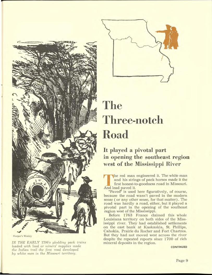
H a rper' s Weekl y
IN THE EARLY 1700's ploddin g pack trains loaded with lead or 1niners' supplies nwde the Indian tmi l t he first road developed by w hite m en in the Missouri territory.
The Three-notch Road It played a pivotal part in opening the southeast region west of the Mississippi River
The red man engineered it. The white man and his strings of pack horses made it the first honest-to-goodness road in Missouri.
And lead paved it. "Paved" is used here figuratively, of course,
because the road wasn't paved in the modern sense ( or any other sense, for that matter) . The road was hardly a road, either, but it played a pivotal part in the opening of the southeast region west of the Mississippi.
Before 1763 France claimed this whole Louisiana territory on both sides of the Mississippi river. They had established settlements on the east bank at Kaskaskia, St. Phillips, Cahokia, Prairie du Rocher and Fort Chartres. But they had not moved west across the river despite the repeated reports since 1700 of rich mineral deposits in the region.
CONTINUED
Page 9

Capitol painting by Berninghaus
THREE-NOTCH
Miners, lead and supplies
quickly n1ade it a road
But the Company of the West, after 1718, sent Phillip Renault from France to work the mines. Armed with three grants of land from officials at Fort Chartres, Renault crossed the river and put his men to work. One of the grants covered two leagues of ground at Mine La Motte.
By 1725 Renault had built a furnace and was gouging out fifteen hundred pounds of lead a day.
The company ran afoul of financial rocks and by 1731 the grants reverted to the French Crown and Renault headed for the Illinois country before returning to France in 17 44.
A well-beaten Indian trail led from Mine La Motte to the Mississippi's west bank across from Fort Chartres. In the mines' early days the lead was hauled to the river and boated across. But Ste. Genevieve, thirty miles northeastofMine La Motte, sprouted on the west bank near the river crossing and by 1735 it was a permanent settle-
Page 10
THE LEAD MINES , opened by the F1' enc h. continued to p1'oduce under Spanish nile . By 1795 more than 300,000 pounds of lead were shipped in a year j?-om Ste. Genepieve.
ment. With the heavy traffic in lead, miners and their provisions moving over the trail, it quickly became a trace and a road. Three Notch Road, it was called, because the route was marked by three notches in trees along the way.
T hese mines helped supply the French with lead throughout their regime which ended
in 1762 when France ceded the territory by a secret treaty to Spain, although the Spaniards did not take possession until 1770.
In the last quarter of the century, St. Louis started to outstrip Ste. Genevieve as the focal point on the Mississippi. But until then this first settlement in Missouri continued to be the warehouse for lead and the storehouse for miners' supplies.
And the pack trains continued to plod over the old Indian trail from the mines to the river and back again until the pendulum of history swung upriver, leaving little trace of this first road in Missouri.

The King's
Highway
This ancient trail
of many languages
linked Spanish
posts together for
military safety and
commerce and trade
DESOTO and his goldhunting Spaniards left his na1ne on an old Indian trail that became an important overland link between early Mississippi settlements.
I n 1770 when the Spaniards took over control of Upper Louisiana on the Mississippi's west side, the country was still
sparsely settled, mostly a haven for fur trappers and traders with few people looking for "settlin' down" land.
St. Louis and Ste. Genevieve were the only permanent settlements- and they hardly ranked as metropolitan areas.
Even twenty-nine years later when Charles Dehault Delassus, Spanish lieutenant-governor of Upper Louisiana, ordered the first census,
Bureau of Public Roads
CONTINUED
Page 11

KING'S HIGHWAY
'No stump shall exceed twelve inches in height'
Missouri's total population was only 6,028. Ste. Genevieve in 1799, with a population of 945, outstripped St. Louis by 24 inhabitants. St. Charles ranked third with 87 5 and New Madrid was fourth with a population of 782.
At first, the Spaniards showed little desire to promote settlement but they soon changed their outlook, wanting settlers to check the English coming in from Canada. They lured settlers ( like the prestigious Boones) with liberal inducements such as tax-free land, including mineral
Missouri Stqte Museum
WHITE MEN made a trail a trace with travel on foot or horseback and a road when they started rolling their wheels over it.
Page12
lands. And they encouraged miners to settle the country and work the mines.
These policies worked. By 1804 more than half of the population of the territory lived south of the St. Louis district. New Madrid, founded by Colonel George Morgan, became a permanent settlement about 1785 and a Spanish post in 17 89. And in 1793 Louis Lorimer's settlement at Cape Girardeau was made an independent Spanish post.
These isolated posts, however, could not guarantee military safety nor facilitate commerce and trade in the country. Something was needed to tie these posts together and to link outlying settlements with them.
By 1776 the Spanish commandant at St. Louis wanted a land connection between the trading posts of St. Louis and Ste. Genevieve. To encourage "regular intercourse" between these two posts, he wanted a ferry over the Meramec river. Jean Baptiste Gamache, in return for a grant of land, started the ferry near the mouth of the Meramec about seventeen miles south of St. Louis. It remained in operation for the rest of the century.
When, at the other end of the string of Spanish posts, a trace was in the making. Soon
after New Madrid was established a trace was marked out leading north toward St. Louis. It generally followed the old Indian trail which DeSoto had traveled 200 years earlier. And it must not have been much improved over DeSoto's time because when Moses Austin traveled from St. Louis to Ste. Genevieve in 1797 to check out mining prospects he crossed the Mississippi river and journeyed down the east side.
But the swelling tide of settlement was making roads an inevitable problem of the government. In 1806, only three years after the United States bought the Louisiana Territory from Napoleon for $15 million, the first territorial road law was passed. This law provided for the establishment of district roads, with each district empowered to have roads surveyed, marked out, made and repaired by order of the district's court of quarter sessions.
Two years later, on June 30, 1808, Territorial Governor Meriwether Lewis signed a law providing for the first specific road in the territory. This road, or "roads," as the law read, was to be laid out "from the town of St. Louis to the town of Ste. Genevieve, from thence to the town of Cape Girardeau, and thence to the town of New Madrid."

I n November. 1808 another act provided for the opening of the roads as one road
from St. Louis to New Madrid. The Road was to pass through four districts and each district was to pay for its part.
Commissioners appointed by the governor laid out the route along the general line of the old Spanish trace, which had mainly followed the ancient Indian trail through the area. Plat and field notes made in 1808 for the Cape Girardeau district stated, "This road follows the Shawanae (sic) trail the whole distance without any deviation from Cape Girardeau to the Indian town."
In January, 1814 the General Assembly of Missouri Territory passed another law declaring all county roads ''laid out by order of court
and according to law" to be public roads. And jurisdiction was switched from the district's court of quarter sessions to the county's court of common pleas.
One section of this law describes the standards for the roads:
"All public roads laid out as now in use, or which shall hereafter be laid out, shall be cleared of all trees and brush at least twenty feet wide, and such limbs of trees as may in-
commode horsemen or carriages, shall be cut away and no stump shall exceed twelve inches in height."
So the old Indian trail grew up, pushed by the white man's military and economic needs. In Ste. Genevieve and St. Louis, where the French influence was strong, the road was called "La Rue Royale." In New Madrid. it was "El Camino Real." In English these became "The Royal Road." "The King's Trace," or"The King's Highway."
Despite its grandiose names, the road was a challenge to all who traveled it. Marked by stumps and mudholes, it was often impassable to wagons and carriages and was hardly less arduous than a trip upstream by flatboat. Although called a road. it was actually a wide
VALLE House, built in 1772, sat by the side of the old King's Highway in Ste. Genevieve It was built by Don Francesco Valle II, the fourth Civil and Military Commandant of Ste. Genevieve from 1796 to 1804.
Division of Commerce
and Industrial Development
pathway cleared - to some degree - ofbrush and timber. Sometimes travelers made the mudholes passable by filling them with rocks or logs. More often a new path was chopped out of the woods, or the trip was cancelled until the holes dried up.
But the path-road filled the white settlers' needs - for that moment in Missouri history. It would change more - as the needs of the people who traveled it changed.
Page 13

Missouri State Museum
Page 14
/ /
/ ..... --
_ ... ,. ...
/
/
/ /
/
By 1820 seiileTs weTe pushing into the wooded hills of southwesten1 MissouTi , assuTing the white man's use of that end of the Osages' ancient trail fTom the V eTdigTis to St. Louis.
'fbis impressive tribe developed most main trails
in South Missouri but one was ''mainer'' than all
The Trail of the Osages
The sober, impressive Osages controlled most of Missouri south of the Missouri river so they developed most of the main
trails in the region. And because they would rather travel a few miles farther to use a beaten path, they made fewer trails but better defmed ones.
The first French explorers in Missouri territory found the Osages living near the mouth of the Osage river. But sometime before 1718 one group moved upriver to near the Osage river headwaters. These were the Great Osages, or Pa-he'tsi, the "campers on the mountains." The rest of the tribe, along with their cousins, moved westward up the Missouri river and set up a village in the Missouri river bottoms in what is now Saline county. These were the Little Osage, or U-tsehta, "campers in the lowlands."
Two Great Osage villages lay on Osage headwaters in present Bates and Vernon counties. From here the Osages walked or rode out along three well-worn trails. One headed northwest toward the Missouri river; its destination apparently switched with the westward tide of white settlement - and its chance for trading. As the Boonslick country opened up, the trail's northern terminus probably was Franklin. Lewis and Clark on their way west mentioned that the Osages crossed the river at Arrow Rock.
One hunting trail led from the Great Osage Villages southeast toward hunting grounds on White river. Here they camped, surrounded by springs, in the vicinity of present Springfield. From there branch trails led off down the White river feeder streams. In 1818 Henry Schoolcraft
in his famous journal referred to the Osage trail down Swan creek as a "horsepath beaten by the Osages in their hunting expeditions along the White River."
From these White river hunts the Osages retraced their trail to the Ozark plateau where the trails branched toward a market. In early days this market was St. Louis so they used the Verdigris-St. Louis trail. Later the market probably was Franklin or Boonville.
Another trail - also for hunting - led southwest, mostly in present Kansas and Okla
homa, to hunting grounds on the Verdigris, the Arkansas, the Red and the Canadian rivers.
Their return trail was the longest and best known of the Osage trails. From their hunting grounds, the Osages headed northeast for St. Louis to trade with the white man. The route roughly followed the highlands between the Missouri and Mississippi rivers, crossing the Gasconade river on its headwaters near present Waynesville in Pulaski county.
One historian reported the trail was "scarcely obstructed by hills," which leaves little doubt as to its general location because no other routes through this country could match that description.
All of the Osages probably used this trail in early trading at St. Louis. Later the Arkansas Osages made good use of it in their trade agreement with the Chouteau family of St. Louis. But it remained primarily an Indian trail until the early nineteenth century because the white settlers had not pushed extensively into the area south
CONTINUED
Page 15

OSAGES
The Southwest country was 'gittin' on
Division of Commerce and Industrial Development
THE MERAMEC Iron Works , established in 1826, used the Osage Trail for h.anling in snpplies and freighting the smelted iron ant.
of the Missouri river and west ofthe Mississippi. In the early 1800's, however, they started
pushing up the valleys of the Meramec, the Gasconade and the Osage rivers, lured by the rumors of rich minerals, furs, the valley land and timber along the Missouri, the Gasconade and Osage rivers. Discovery of iron ore along the Meramec near present St. James anchored the white man's use of the center of this old Indian trail.
About 1828 Thomas James, along with Samuel Massey and more than one hundred laborers, started erecting the Meramec Iron Works. By 1837 wagonloads of iron were rolling to many parts of the state, with much of it freighted overland to St. Louis. And supplies for the mines came back the same way.
Six years before that, in 1831, two postoffices were operating in the area- oneatPiney, about ten miles southwest of present Rolla, and one at Meramec. So the white man's needs were solidifying his use of the old Indian trail and making it a road.
Page 16
The other end of the old trail was going through the same evolution as settlers pene
trated into southwest Missouri along the White River. Legal complications, however, slowed the development of the area.
The U.S. Government had granted reservations in the area to the Delawares in 1818 and to the Kickapoos in 1819. They started moving in for permanent occupancy in about 1822 -and, of course, found themselves in a hassle with the white settlers.
The government finally upheld the Indians' rights and the white settlers moved out, some to the already established settlements on the Meramec and Gasconade headwaters. But for the Kickapoos and Delawares the victory was only a delaying action. In 1832 they ceded their claims to the United States and many of the early white settlers returned to make their homes there.
These settlers, like others elsewhere in Missouri, came from everywhere. As the frontier advanced they moved with it, like old Squire Ezekiel Hagan. He had moved from Virginia to western Carolina and then to Tennessee, and when land hunters came in with good news from Arkansas and Missouri, he planned to "git on."
This southwest region was "gittin' on," too. Greene county was organized in 1833 and
by 1835 a land office was _opened in Springfield, on its way to becoming themostimportanttown in the region. A state road was authorized from St. Louis to Springfield, with the authorization coming in sections. The first legislation was approved February 6, 1837. By then immigrants into the region were flocking over it and its niche in the history of Missouri highways -past, present and future - was carved clearly.
Early settlers had called it the "Osage trail" or the "Indian trail." Later it was called the "Kickapoo trail." But the white man's stamp was marked indelibly on it when it became known as the "old Springfield road or the "St. Louis-Springfield road."
Progressing through various names and numbers, it became the fabled U.S. Route 66 of story and song. And today, in thelateststage of its evolution as Interstate Route 44, it serves the white man's needs as it once did the Indian.

l
·,,. T-~·:.r: ·::__
· :·:~-,;~~~rF:t:t:·'f~~,<)~_ ·:-· --::;. ·
·- o;,.:_ l.,.r ~ - ~ :
- . F>'
\\~~~-""7') __ , ........ . . ~ ..
Missouri Historica l Society
BY WAGON, on foot and on horseback, the seitlers stremned westward into-and thmugh-Missouri along the Boones' route to the salt licks country.
The Way to Boone's Lick CONTINUED
Page 17

WAY
'fhe influx of settlers soon 1nade a road out of the old trace leading to the \Vest
When Daniel Boone moved his family into Missouri from Kentucky he set in motion a series of events which were to stamp Mis
souri forever with the Boone name and which were to open up the first early road not based on an Indian trail.
The Boone family, during the Spanish regime, settled in the Femme Osage region about twenty miles west of St. Charles. Then in 1806 Daniel Morgan Boone and a brother traveled west to present Howard county to make salt. No Boones
There was
'plenty of roon1'
in the Boons Lick
Country--and they
headed for it
settled at the salt licks but their reports kicked off a stream of immigration and the region became known as the Boonslick country. Five years later, in 1811, Henry Marie Brackenridge on his voyage up the Missouri river found seventy-five families along the river's north bank within a radius of four or five miles.
Indian troubles during the war with Great Britain ( 1812-1814) stemmed part of the tide of immigration into the Boonslick country until 1815. Then peace treaties with various Indian tribes at Portage des Sioux were made and settlers again poured into the area.
In three years the thirty families of whites above Cote Sans Dessein had jumped to more than eight hundred families. And Franklin, the western edge of the frontier, was growing faster than any settlement on the Missouri. By 1819 the Missouri Intelligencer reported that during October 271 wagons and four-wheeled carriages and 55 two-wheeled carriages and carts passed
Page 18
near St. Charles bound for the Boonslick country. One writer said he had counted a hundred wagons a day passing through St. Charles at times.
Asa Morgan, in an advertisement in the October 26, 1816 Missouri Gazette, reported from Howard County ( commonly called Boons-Lick Settlement):
"Missouri and Illinois present an interesting spectacle at this time. A stranger to witness the scene would imagine that Virginia, Kentucky, Tennessee and the Carolinas had made an agreement to introduce us as soon as possible to the bosom of the American family. Every ferry on the river is daily occupied in passing families, carriages, wagons, negroes, carts, etc. - respectable people, apparently able to purchase large tracts of land. Come on, we have millions of acres to occupy, provisions are cheap and in abundance."
WHILE Daniel Boone settled down in his son's home in eastern Missouri, the tide of settlers pushed on westwm·d, m.any in coaches as the land became "civilized".
Morgan just happened to have a few acres himself; in fact, a deed of Morgan's to a tract of land from a Frenchman, Joseph Marie, dated 1800, is the first authentic record of settlement in Howard county. "Boons-Lick Settlement," that is.
At any rate, the people kept coming.
To help the travelers along the road the Misso!.lri Intelligencer in 1835 published a highway mileage log -which would at least help them figure how far out of their way they had strayed.
According to the log, it was 116 miles from St. Charles to Columbia via Fulton. That was chopped up like this:
"From St. Charles to MConnell's - 9 m'iles; to Alexander's - 5 miles; to May's - 10 miles; to Pringle's - 6 miles; to Taylor's - 5 miles; to Pendleton's - 10 miles; to Boyd's - 2 miles; to Widow Kabler's - 1,4 mile; to Jones' - 4 V2 miles; to Ruby's - 3 miles; to Lewistown - 3V2 miles;
..
I
to Monroe's - 8 miles; to McMurtree's - 10 miles; to Grant's- 4 miles; to Fulton- 12 miles; to Millersburgh- 12 miles- to Vivan's- 2 miles; to Parker's - 5 miles; to Columbia - 5 miles."
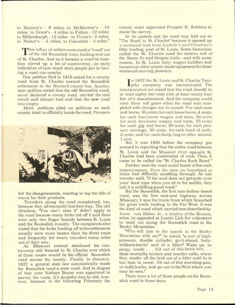
T his influx of settlers soon made a "road" out of the old Boonslick trace, leading west out
of St. Charles. And as it became a road its location stirred up a bit of controversy, an early indication of how much store people put in having a road run nearby.
One petition filed in 1816 asked for a county road from St. Charles toward the Boonslick settlements to the Howard county line. Another later petition stated that the old Boonslick road, never declared a county road, carried the real travel and always had and that the new road was empty.
More petitions piled on petitions as each county tried to officially locate the road. Farmers
led the disagreements, wanting to tap the tide of travel for their products.
Travelers along the road complained, too, because they all too easily lost their way. The old direction, "You can't miss it" didn't apply to the road because many forks led off it and there were only two finger boards between St. Louis and the Boonslick country. The complaints also stated that the forks leading off to the settlements usually were more beaten than the direct route and frequently led weary travelers many miles out of thelr way.
As Missouri entered statehood the con-troversy still festered in St. Charles over which of three routes would be the official Boonslick road across the county. Finally in January, 1827 a general state law automatically made the Boonslick road a state road. And in August of that year Nathan Boone was appointed to survey the route. It's doubtful that he did, however, because in the following February the
county court appointed Prospect K. Robbins to make the survey.
At its eastern end the road was laid out as "The Road to St. Charles" because it opened up a westward trail from Laclede's and Chouteau's little trading post of St. Louis. Some historians called the St. Charles road the eastern end of the Santa Fe and Oregon trails - and with some reason. In St. Louis forty wagon builders and numerous other plants made equipment for these westward-moving pioneers.
I n 1837 the St. Louis and St. Charles Turnpike company was incorporated. The
incorporation act stated that the road should be at least eighty feet wide with at least twenty-four feet of it macadamized. And the company could erect three toll gates when the road was completed with charges not to exceed: For each man and horse, 614 cents; for each loose horse, 4 cents; for each four-horse wagon and team, 30 cents; for each two-horse wagon and team, 25 cents; for each gig and horse, 20 cents; for each pleasure carriage, 30 cents; for each head of cattle, 2 cents; and for each sheep, hog or other animal, 1 cent.
But it was 1865 before the company got around to reporting that the entire road between St. Louis and the Missouri river opposite St. Charles had been constructed of rock. Thus, it came to be called the "St. Charles Rock Road."
Farther west the road could boast offew such improvements. Even the man on horseback at times had difficulty mudding through. As one traveler said, "If the mud does not get quite over your boot tops when you sit in the saddle, they call it a middling-good road."
But the Boonslick, the first non-Indian based road, was the first east-west highway across Missouri; it was the trunk from which branched the great trails leading to the Far West. It was the kind of road which carried men described by Isaac van Bibber Jr., a relative of the Boones when he appealed at Loutre Lick for volunteer~ to head out along the Boonslick road to the Rocky Mountains:
"Who will join in the march to the Rocky Mountains with me?" he asked, "a sort of highpressure, double cylinder, go-it-ahead, fortywildcats-tearin' sort of a feller? Wake up, ye sleepy heads ... Git out of this brick kiln ... these mortality turners and murder mills, where they render all the lard out of a feller until he is too lean to sweat. Git out of this warming-pan, ye hollyhocks, and go out to theW est where you may be seen."
There were a lot of those people on the Boonslick road in those days.
Page 19
'·
" ...... , \
'•\\ \'
',
On the move by land, water~
Missouri Historical Society
Page 20
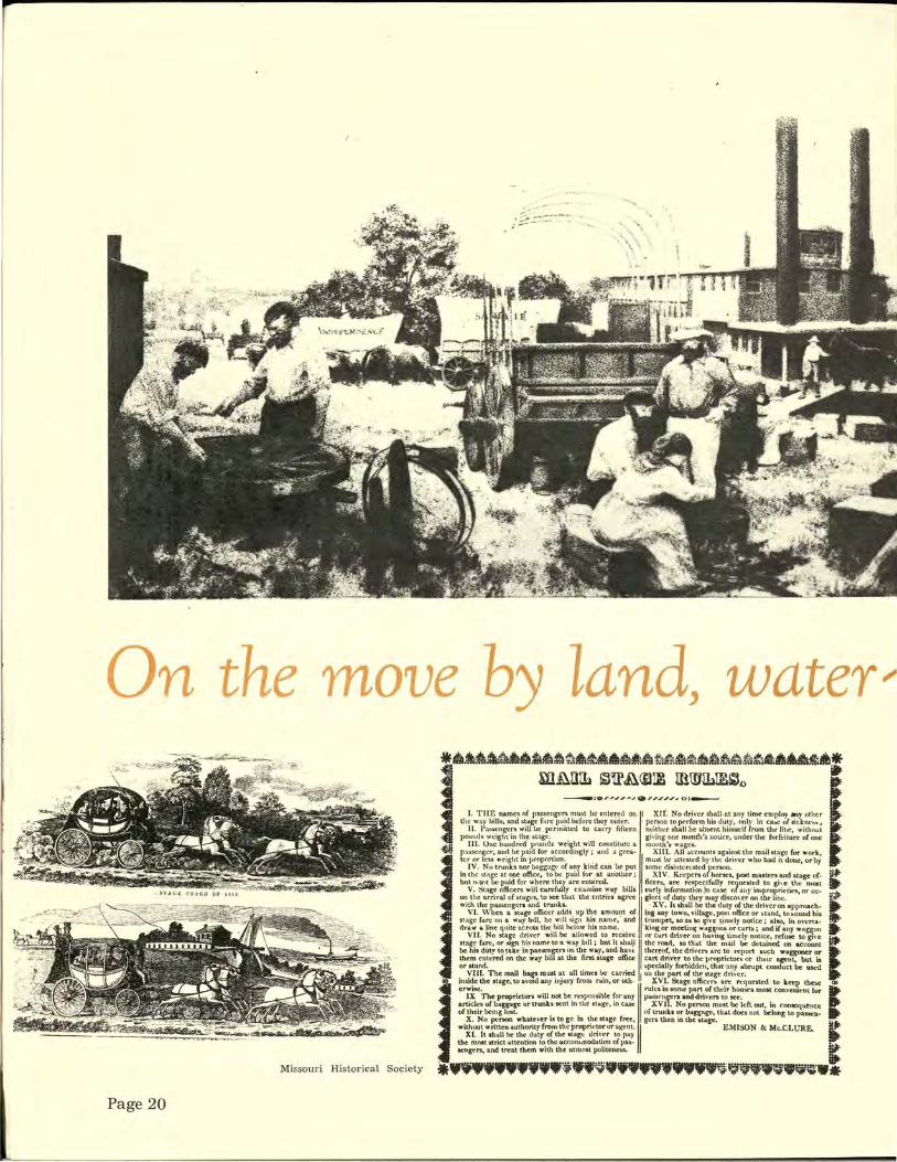
fflll.~·fM'i.4ll• .. :t~IA!I'Ilrt.~•~·tiJu•u~~sfll~~!tl~~l!l~ll!!l~i~~66MdJif ::f W~lliL ~~A<Slt ID.IJJILlE~o it'
I -fli
---:or.~,,..,.J • ,.,.,,,.J o:---
I. THE names. of passengers must .be ente~tl 1?1! I XII. No drh•er shall. at. any time employ aty other the way bill!i; Rhd stage far~ p<lid bdorc th\:y cuttr. ' penoil to pcrfo\'m hi1 duty, only in· ca&C of iidm·!l!>,
11. Paslic••gers will be .permitted to carry fifteen m.:ith~.:r shall )le absent himself from th~ lil•e, without pounds wcight' in th~ stagt:. . gi"ing one month's notice, unde1· the furftiturc: o£ one
lll. One hundred pounds weight will constitute a month'11 wagc1. passeug~:r, and be paid for a~COl'diugly; aud a grca- XIII. All accounts agai~st the mail st~ge for work, tcr or less weight m proportion. . I must lt(' attCI5tl'd by the l.lrn·er who had 1t done, or by
IV. No trunks nor baggage of any kind can be put some disintcn.:sted person. ,. in the st1tge at ont.office, tobt: paid for at another; XIV. Kecpt-no(hor~s. post masters and stage of- • but u . u~ lx: p.Ud for where they are entered. ficcrs, are rc~pectfully re< ues.tt:d to gi\e the me&t .
V. Stage tlAkers will caref~:~lly txamine !"•Y bills early info1'nmtion j11 C<tSC: · o~ any in1pror;>rietit>s, or nc· a~ on the arri\'1\l ·ofstagcs, •.o see tbat the .entnt:a ag~ I glec;tnf duty._tbry may di!SCOl'er on .tbe line.~·~ with the passengers and trunks. . . · XV. ltllball be ·the duty of the Uriveron approaeh-
VJ. \\'hen a stt~ge officer a~ds. up t~e •m~u.lt_ tlf .. i.ul aoy to:ovn, _villa~, J>?Sl office ~r ~~ott~nd, to_~~oouud his stage fare on a way b•ll, he wtll !llgn hit. nan.e, and trumpet, 10 aJJ '«) tf!Ye ~!Indy notice; abo., m oveMa· ~-draw w.line quite ac~oss . tbc. hill ~low his name. . . "king. or meetiu~~; .wag~on~ ~rcarb; and U any w~tg~on
be his dUtv totik.t: in pas!ien~r3 on t}le way, and ·h~vt: thc1~of, ·tbcdri\·cn arc to report such waggooer or them entt:'re<f"on the w~y bill at the first.1tage oftict: cart drh"er ' to th~: proprietors or their ~nt, but is or stand. ~~opcciaUy fort>idde-n, that .-any at>rupt conduet be ukd
VH. No star: d~Jver -w1ll ~ aUowed to receiVe nr c-.trt dril·er -c::m -~&\'mg u.mely · notic~, refuse to gu·e ~ etage fare, or Ngn hts uame to a w. ay .b1l1 ; but It sl.Htl.l I the road, ao _tliat the .mrul be dtt:uned on ac-count
VIII. The mail ba~ must at all timc.-s be ·Cat!ied I on the part of the stage dri,·cr. Jii" inside the stage; to a\"O!d any inju11 froru r~~o1n," or oth · XVI. Stage offic~rs are n-quested · to keeJ.> these
J erwi~~e. I rules in 110m~ part of th~ir hou!it's most convelut·nt for ~
IX The proprieton will n~ be responsible for any pas"sc-n n and-drh·en to see. articles of bagg11~ or trunks sent ill the stag~, in Cllk XV l{ No person must be h:ft out, in consequence of ,their bemg lost. of trurlb or ban:nge, that does not bc:Jont to paS¥t:n-
X. No penon whatever i1 to go In the stage free,- gers then in the &to.ge. 1: without wnttt:nauthontyfromthcproprit'tororagt"nt., EMISON & Mc.CLURE.
XI. It shall be the duty of the llto-l.gc dnver to pay the mnat atnct ;.attenbon to the aeconunod.ttlon oflJ&II'· • ~engers, and treat them with the utmost pohtene"-'· iiJI.
.... _... ... :;;"~91f'fft'f~fi~WV9RW•

• atr
Missouri Historical Society
;r. D. :NI:'.A..UL:XFF,
Carriage Manufacturer, CORNER OF TWENTY-FIRST ST. AND FRANKLIN AVENUE,
DEPOT NO. 33 THIRD ST,, BET. PL'IE AND CHESNUT,
IJdi~ LOUIS, Keeps eolll!tantly on hand, and make• to order,
Rockaways, Buggies and Traveling Wagons, OF EVERY DESCRIPTION.
REPAIRING DONE AT THE SHORTEST NOTICE.
Missouri Historical Society
--==-===='TH"'E'-"s,._.TU'-"'D=EBAKER WAOO·=· = =--=---LUXURY ON WHEELS.
"Walt tor the Wagon and We'll all Tuli.e a Ride."
"Gold Basis"'iatons and BnWe~. which means Roct·Bonom, Hard·Paal'l'i=
Merrh &n t•, ,.., ~•o lu r· IIIah 7<>U I ..... ..! Cll'f'n llu.ac• l ~uld t .. ot>l"r f llll T<>t• ""~~~-. I t•••. ,.!;~ •w,~·:~;7t~ r"" • ~ '" ' ..... ~ , .. , .. ~ \\ .. r:·~; ',.,•::~:: . W h...,l: 1'~1-
~~·.\ \I'IIH I ,
~~~
81udeht.k ~r' 1 "U,j,J K;oo1 1" l'lt.U<oOU :ipfiU!I Wa~ODl.
W• pn~p.k,... ,.h•ll••· ~~' .. ·~··~.." .~: ... ,. ..... . lal· f<m~>!Spriq
""•"""· ·l'j•tllll( "'• I"UI Llefi Y• ~•J II a,c:••aa, ~ ...... ... _ ......... t:~i.-:)::: ~~~~~-; ~ .......
We md:e '' 8TUDEBA.KER'8'' 8prio & W orlr a 8peoiaU7- .A.Wo, •tuct.baller'• Celebr1ted Farm W&.ODI,
Co rr.1pondeP.M promp~I J" atte n d ed t o, &P.d Cat~oaua .Prt" L'-' .. fun!MM4
TRUMBULL, REYNOLDS & ALLEN
HOLDEN'S CELEBRATED
GMIJeS~ Most Durable • Convenient C..loo..,.._ ... ~••l--•oc-ia • --'otJ.o .
._._,_..,._ DtW ..toll .,....... olot"" m .... ... u- ; otloo,-._-. .... -__... TlleA-iobol4 =~=_..,.....,..,...., ... ,.,... .. u.,po. .;c.w, oo • ·
fib MJ Dari"JI lillllr 1111 r Lulla, u4 al111 L!D!fi,
' B"ORII.A..LR BY
-~ Q.Schott Sz::d~lo:·v CJ.
IN THE 1800's people were on the move into and through Missouri in almost every conceivabl~ kind of transportation. By water they came, in luxury steamboats and rough keeLboats. Overland they came, by foot and by covered wagons , buggies, stagecoaches, and carts. And some tried to move on west from Missouri in the legendary windwagon with sails hoisted to the prairie breezes.
Page 21
"""
Missouri State Museum
By the Side of the Road
.,,.,,.'l'l!'l"lSl',/'ff[(Wt:.,>'>'' !: ·~~-=:·~-:--:\~· .... ~?. # ;,•! ·~. ·.~
. -~;, ,q
Where three skeins of history came together
Missouri Historical Society
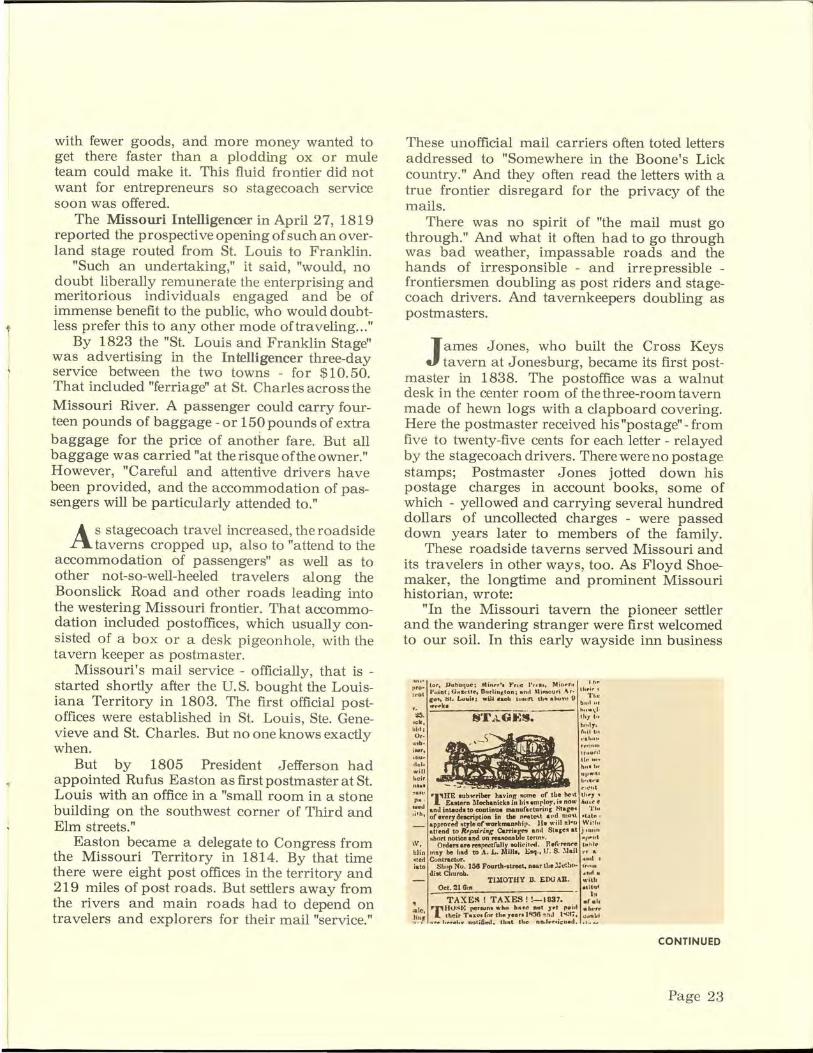
STAGECOACH travel could be crowdedand bone-wearying-on long trips.
Page 22
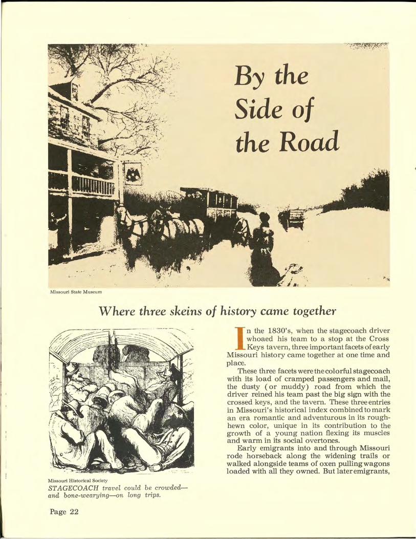
I n the 1830's, when the stagecoach driver whoaed his team to a stop at the Cross Keys tavern, three important facets of early
Missouri history came together at one time and place.
These three facets were the colorful stagecoach with its load of cramped passengers and mail, the dusty ( or muddy) road from which the driver reined his team past the big sign with the crossed keys, and the tavern. These three entries in Missouri's historical index combined to mark an era romantic and adventurous in its roughhewn color, unique in its contribution to the growth of a young nation flexing its muscles and warm in its social overtones.
Early emigrants into and through Missouri rode horseback along the widening trails or walked alongside teams of oxen pulling wagons loaded with all they owned. But later emigrants,
with fewer goods, and more money wanted to get there faster than a plodding ox or mule team could make it. This fluid frontier did not want for entrepreneurs so stagecoach service soon was offered.
The Missouri Intelligencer in April 27, 1819 reported the prospective opening of such an overland stage routed from St. Louis to Franklin.
"Such an undertaking," it said, "would, no doubt liberally remunerate the enterprising and meritorious individuals engaged and be of immense benefit to the public, who would doubtless prefer this to any other mode oftraveling ... "
By 1823 the "St. Louis and Franklin Stage" was advertising in the Intelligencer three-day service between the two towns - for $10.50. That included "ferriage" at St. Charles across the Missouri River. A passenger could carry fourteen pounds of baggage -or 150 pounds of extra baggage for the price of another fare. But all baggage was carried "at therisqueoftheowner." However, "Careful and attentive drivers have been provided, and the accommodation of passengers will be particularly attended to."
As stagecoach travel increased, the roadside taverns cropped up, also to "attend to the
accommodation of passengers" as well as to other not-sa-well-heeled travelers along the Boonslick Road and other roads leading into the westering Missouri frontier. That accommodation included postoffices, which usually consisted of a box or a desk pigeonhole, with the tavern keeper as postmaster.
Missouri's mail service - officially, that is -started shortly after the U.S. bought the Louisiana Territory in 1803. The first official postoffices were established in St. Louis, Ste. Genevieve and St. Charles. But no one knows exactly when.
But by 1805 President Jefferson had a ppointed Rufus Easton as first postmaster at St. Louis with an office in a "small room in a stone building on the southwest corner of Third and Elm streets."
Easton became a delegate to Congress from the Missouri Territory in 1814. By that time there were eight post offices in the territory and 219 miles of post roads. But settlers away from the rivers and main roads had to depend on travelers and explorers for their mail "service."
These unofficial mail carriers often toted letters addressed to "Somewhere in the Boone's Lick country." And they often read the letters with a true frontier disregard for the privacy of the mails.
There was no spirit of "the mail must go through." And what it often had to go through was bad weather, impassable roads and the hands of irresponsible - and irrepressible -frontiersmen doubling as post riders and stagecoach drivers. And tavernkeepers doubling as postmasters.
James Jones, who built the Cross Keys tavern at Jonesburg, became its first post
master in 1838. The postoffice was a walnut desk in the center room of the three-room tavern made of hewn logs with a clapboard covering. Here the postmaster received his "postage"- from five to twenty-five cents for each letter - relayed by the stagecoach drivers. There were no postage stamps; Postmaster Jones jotted down his postage charges in account books, some of which - yellowed and carrying several hundred dollars of uncollected charges - were passed down years later to members of the family.
These roadside taverns served Missouri and its travelers in other ways, too. As Floyd Shoemaker, the longtime and prominent Missouri historian, wrote:
"In the M issouri tavern the p ioneer settler and the wandering stranger were first welcomed to our soil. In this early wayside inn business
lUb•
j .. ,,
t iiU~
rid~
will heir
("1\.' 111.
~,:~~~~ ·1~ 1~,~~:1r~:.!:k~"i~ 1~:.~;,~;~i~ ~= ~~~:!; ~·'-' llnd inteuda to continue manufacturins Stage.. '1'111
•• •h, ofeverydeterit'tion in the nMlt~t a r· ~ m•n l ''.~.t.-. · _ apprnved Mtyleofworkman!i!hip. lie wrll n.l-:o _WI! !"
attend to Rfpoiring Carri•~ anti Sta,el'l&t punn short notice and on rea110ttab1e term~. "ll'"llt
\V, Orders an respectfully solir:i tOO. Reft·renl"e ht hle l:liu rnsy be had to A. L . .1\lills, Esq., IJ. S. :'.Jail N "
-.ted Cuntractur. ttml r iato Shelp No. JM Fourth•street, near the :.:ct!ac.. ,·,,.,u
ditt Churoh. .nd N
TlllOTHY D. EOO All. • ·;<b Oct. 21 Gu' •titrat -- - . h
TAXE~! TAXES! !-1037. "'"'' ~ J P'rti\J~ I•: rerlk)n• •·ho hut! ftOl .Jf'l rP ill ai!C'tf'
:~.~~; .• r .. , .' .. ~:;~;r:=~~:. n;~,!:~~;~.!~3~~~~~•i!:~: ~;:.".~.~ .
CONTINUED
Page 23

SIDE
The Missouri tavern 'served as home and ,;)Jt,"f"(!l" '
--"::::"""'~'""""''"Y !Oi~ '~""i ·''"'~'''''"'·"'''''''':::~~=~~"" c: a zp;,~.t;;iili"..,......,..·-;~-"' ... -.---.... ..,..~ ... ~-
--=-·~·~ ... .,..,"' ...... w,lt~~~2t!'.f'J.!~~~'W~~'i.:t:C~\"t:dl~~:r.:i*.· .- - "' .•.. :.:t .... "' ~,........,., _ §II
was transacted, religion preached, duels decided, politics discussed and frequently settled, towns founded, courts convened, and hospitality dispensed. It served as home and mart, court and forum. It was the product of a pioneer community, peopled by an honest, fearless, hospitable folk. Conditions produced it that will never return ... "
Missouri was born a state in a tavern, the Missouri in St. Louis. In the same tavern, the state's first legislature met and Alexander McNair was inaugurated as the state's first governor there. And in it the state's first U.S. senators, Barton and Benton, were elected.
Taverns, in addition to a lot of other goingson, featured a wholelotofplainpreaching.
In fact, the combination of tavern keeping and preaching was fairly common. The Rev. Andrew Monroe, for ir1stance, one of the state's first
Page 24
TAVERNS, along with handling mail, competed with each other in refr eshment-food and liquidand the many m ethods of f--ontier news-spreading.
prohibitionists and a Methodist minister, operated a tavern near present Danville.
But the Reverend, stopping at another tavern, (Kenner's near Paudingville) had to take a back seat at blessing time. Kenner asked his own blessing at mealtime, concluding: "And for all these blessings we thank Thee, 0 Lord. Amen. Kick that blamed dog out from underthetable."
Dogs might have to be kicked out from under the tables but those tavern tables usually were loaded with good frontier food. And the price was reasonable, if not downright cheap, even for those days.
William Rice's tavern on the Boon's Lick road in Montgomery county featured probably the state's first European plan tavern menu. Dinner consisting of corn bread and "common fixin's"
~

mart, court and forum .. . ' was twenty-five cents; wheat bread and "chicken fixin's" were thirty-seven and one-half cents- or three bits, in the frontier vernacular. Both kinds of fixin's cost five bits - or sixty-two and onehalf cents.
The westward flow of Missouri settlers - and the ones pushing even farther on - pulled the roads westward with them. And following along came the stagecoaches, with passengers and mail sacks rattling, and the taverns with good food and talk. Or at least both in good quantities.
A ny grumbling about the fixin's carried an element of danger. John Graves, the first
tavern keeper in Chillicothe, kicked a food grumbler out the door one day with this explanation:
"The blamed skunk insulted my boarders and I won't standforit. Myboarderseatmy fare and like it; and when a man makes fun of my grub, it's the same as saying they haven't sense enough to know good grub from bad. I'm bound to protect my boarders."
As the roads and stage and mail coaches -and the accompanying taverns - were pulled westward, the horizons of these enterprising frontiersmen widened.
During the 1830's and 1840's the rapidly expanding settlements demanded better and more mail facilities, and numerous post roads
FORDING rivers at night could be an exciting experience and evidence of the n eed for bridges.
were laid outinMissouri. In 1850GeorgeSmith, the founder of Sedalia, had a contract with the U.S. government for operating passenger and mail coaches over 483 miles of Missouri stage lines. And in 1850 Sam Woodson started a monthly stage run from Independence to Salt Lake - along with a mail contract for a regular, dependable income.
In the same year, on July 1, the first mail stagecoach between Independence and Santa Fe rolled out on its first trip to the Southwest over the famous trail first marked out by Pedro Vial in 1792 and re-blazed by William Becknell in 1821 and 1822. The stage was operated by Waldo, Hall and Company under contract with the U.S. government. It ran once a month until 1857 when it started semi-monthly runs. Then came weekly service in 1858, tri-weekly in 1866 and daily service in 1868.
T he Santa Fe and other famo"" trails which originated in Missouri combined with rail
roads to lead the ever-onward pioneers to the Far West. And they pulled the stage and mail coaches with them.
After a long and bitter fight to establish mail delivery to California a company headed by John Butterfield in 1857 won the contract, backed up by a $600,000 annual appropriation
CONTINUED
Page 25

SIDE
From Missouri the coaches rolled west
THE MONTHLY stage for Salt Lake City, run by Sam Woodson by 1850, leaves Independence on its long trip that -sometimes induced what some write1·s dubbed "stage craziness."
by Congress. Butterfield's line, with more than 100 Concord coaches, a thousand horses and 500 mules and 7 50 men, stretched from Memphis and St. Louis in the east to San Francisco in the west. Mail and passengers rode from St. Louis to Tipton on the newly-laid Pacific Railroad. There they transferred to stage coaches which swung on a great arc through Springfield to meet the Memphis stage at Little Rock, and from there on through Preston, Texas to San Francisco. The distance - nearly 2,800 miles.
Page 26
Postage rate was 20 cents an ounce for letters and passengers' fare was $100 in gold.
John Hockaday, in 1858, joined the stagecoach entrepreneurs with a line from St. Joseph to the army posts in Utah. And in April, 1860 the Pony Express kicked up its heels in a brief but colorful episode.
As the westward rush stretched the stage and mail coach lines and the roads over which they traveled and the taverns where they stopped, the historical triplets left in Missouri started a new era, an era which would lead to new forms for them - and new contributions to the development of Missouri.
THE DIVISIONS REPORT
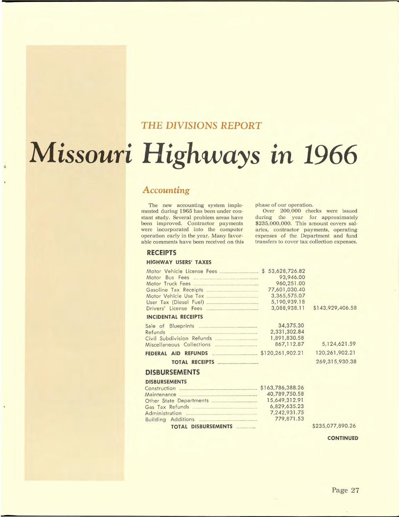
Missouri Highways • tn 1966 Accounting
The new accounting system implemented during 1965 has been under constant study. Several problem areas have been improved. Contractor payments were incorporated into the computer operation early in the year. Many favorable comments have been received on this
phase of our operation. Over 200,000 checks were issued
during the year for approximately $235,000,000. This amount covers salaries, contractor payments, operating expenses of the Department and fund transfers to cover tax collection expenses.
RECEIPTS HIGHWAY USERS' TAXES
Motor Vehicle License Fees ----------- ··----------- $ 53,628,726.82 93,946.00
960,251.00 Motor Bus Fees ___ ---------------------- --·----·------Motor Truck Fees -------------------------- --Gaso I i ne Ta x Receipts -------------------------------Motor Vehicle Use Tax -------------------------------User Tax (Diesel Fuel) -------------------------------Drivers' License Fees ·-------------------------------
INCIDENTAL RECEIPTS
Sale of Blueprints ---------- --------------------------Refunds ___ ·-------------· -------------------- ___ -----· _____ _ Civil Subdivision Refunds __ _____________ _
M i see II an eo us Co II ecti on s --------------------------
FEDERAL AID REFUNDS ---------------- ------------
TOTAL RECEIPTS
DISBURSEMENTS DISBURSEMENTS Construction ----------------------------------- ------------Ma i nte n a nee ------·----------------------------------------Other State Departments -----·---- -----------------Gas Tax Refunds ----------------------- ----------------Administration -----·---------------------------------·----Building Additions -------------------- ___ _________ __ _
TOTAL DISBURSEMENTS ____ _____ _
77,601,030.40 3,365,575 .07 5,190,939.18 3,088,938.11
34,375.30 2,331,302.84 1,891,830.58
867,112.87
$120,261,902.21
$163,786,388.26 40,789,750.58 15,649,312.91
6 ,829,635.23 7,242,931.75
779,871.53
$143,929,406.58
5,124,621 .59
120,261 ,902.21
269,315,930.38
$235,077,890.26
CONTINUED
Page 27

THE DIVISIONS REPORT
Bridges
During the year designs were completed by the Division of Bridges and contracts let for 250 new structures. Of this number, 128 were for the Primary system routes and 122 were for the Supplementary (farm-to-market) routes.
The total length of all new structures contracted for during 1966 amounted to 49,053 feet at a cost of $23,479,414. Of these amounts, 17, 123 feet, costing $5,828,832, were for the Supplementary routes.
Thirteen designs also were prepared for repairing, widening or extending existing structures by contract at a cost of $285,215; total length was 1,217 feet.
Construction
The awards of contracts in 1966 covered 329 projects and sections and involved approximately 1,050 miles of Missouri roads. The dollar value of awards, including engineering and noncontractual costs, totaled $134 million. The breakdown of awards made by the Commission are as follows:
About $65 million for the Interstate system.
About $4 7 million for the Primary system.
About $20 million for the Supplementary system.
About $2 million for non-contractual costs.
Included in the work for the Interstate system are screening, rest area and beautification projects. Included in the work for the Primary and Supplementary system are projects financed wholly by state funds.
About 45 miles of Interstate roads were completed this year, and 100 miles are
now under contract. Missouri now has 608 miles up to Interstate Standards and an additional 130 miles in use as a dual facility , but not up to full Interstate standards.
Interstate Route 70 is complete across the state. Interstate Route 44 from Route 244 near St. Louis to the Oklahoma state line is a dual lane facility with approximately 50 percent up to full Interstate standards.
Interstate projects completed this year include work in St. Louis, Kansas City and in the vicinity of St. Joseph , Winston, St. Peters, Kearney, Leasburg, Concordia, Imperial, Marston, Wentzville, Rolla, New Madrid and Cameron.
Active Primary work included projects in the vicinity of St. Louis, Kansas City, Thayer, Sedalia, Jefferson City, Nevada, Dexter, Columbia, Hannibal, Springfield, Weldon Springs and Doniphan.
ACTIVE PROJECTS AS OF DECEMBER 31, 1966
Contracted Contracted Contracted Contracted in in in in
System 1963 1964 1965 1966 Totals Interstate 1 4 15 43 63 Primary 0 2 11 27 40 Supplemental 0 0 10 29 39 Rte. & Sec. 0 1 10 127 138 Totals 1 7 46 226 280
Page 28

Equipment and Procurement
During the year 56 units of rental equipment were bought outright and 602 units were replaced through trades. At the close of the year the Division was ma intaining 5,832 units made up of passenger cars: pickups, trucks , carryalls, tractors , tractor mowers, motorgraders a nd various miscellaneous units.
It required 8 ,000, 700 gallons of gasoline, 730,800 gallons of kerosene, and l, 562,100 gall ons of diesel fuel to operate the fleet. In addition, 152,275 gallons of lubricating oil, 17,128 gallons ofhydraulic oil, 55,438 pounds of multi-purpose gear oil and 40,526 pounds of lithium grease were used.
Tires and tubes costing $259,154.63, tire chains costing $3,5 19. 13, anti-freeze in the amount of $17,444.61, and shop equipment, parts a nd supplies totaling $1,906,485.78 were contracted for during the year.
The quantities of materials used in the maintenance of ou r highways and bridges are listed below: Various Types of Asphalt ... 69,054,448
Gallons Gravel ..................... ............ 1,543,940
Cubic Yards Stone and Chat .... _............. 1,491 ,001
Tons Paint .......... ............................. 562,305
Gallons Reflectorizing Spheres ............ 2,606,350
Pounds Sodium Chloride (Winter 1965-66)
25,317 Tons
Calcium Chloride (Winter 1965-66) 2,340 Tons
Grader and Maintainer Blades 1, 740,053 Pounds
Agricultural Seed ............ ...... 125,4 78 Pounds
Mower Parts .................. $102,247.60 Our Headquarters Sign Shop produced
92,058 signs and markers of various shapes and sizes amounting to $872, 106.40 during the year.
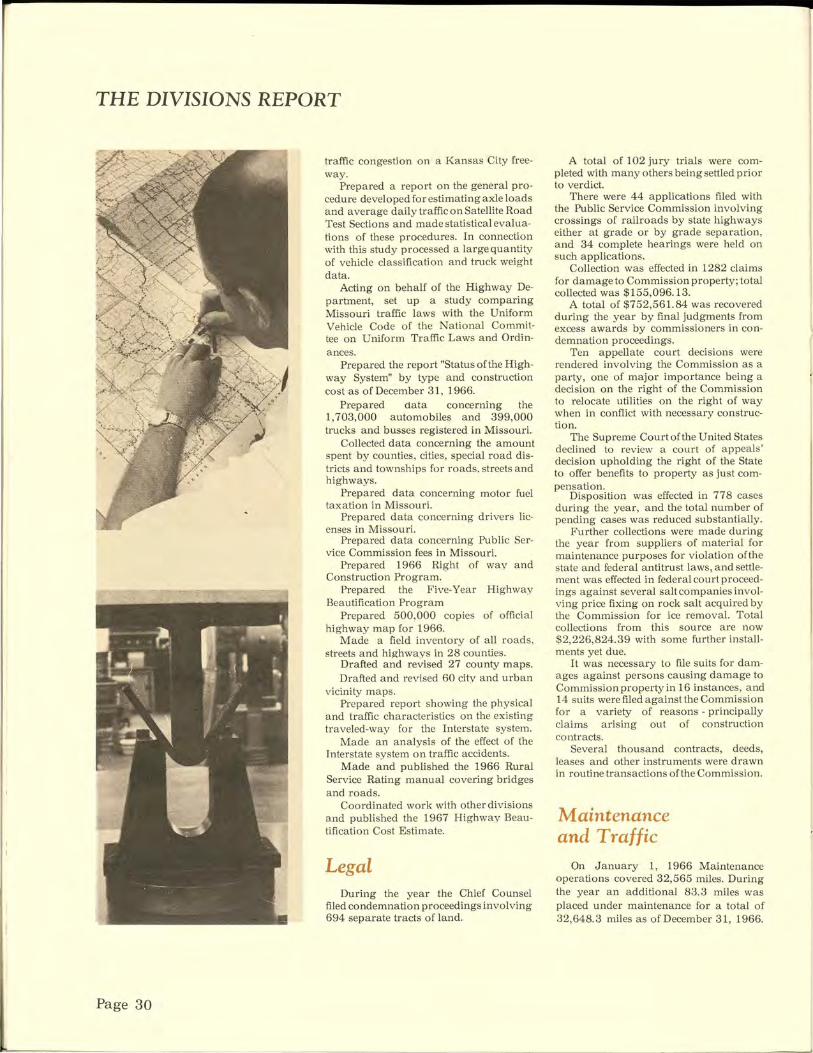
Highway Planning
During the year personnel in this di v ision:
Continued the development of the St. Louis Transportation Study.
Translated all interview data from the ~t. Louis Origin and Destination Survey mto proper form , suitable for analysis, through EDP.
Published "St. Louis Area Transportation Study, Traffic Volume Summary 1965-1966."
Developed the necessary models for trip analysis to be used in the Kansas City Transportation Study.
Continued the development of the transportation studies for Columbia, l;Iannibal and St. Joseph.
Published Volume II of "Future Travel and Transportation Needs" for Springfield.
Published the technical report for the "Moberly Area Transportation Study".
Continued vehicle speed classification and truck weight studies.
Made more than 7,600trafficcountsto determine traffic volume.
Operated 105 permanent traffic counters to determine traffic trends.
Made roughometer surveys on 351 miles of new or resurfaced pavement and on 66 new bridges.
Prepared and published external origin and destination traffic studies for the cities or areas of: Carro1lton, Granby, Hillsboro-DeSoto, Lexington, Marshall Richland, Richmond and Troy.
Processed over 800 requests fo r traffic information from within the Highway Department and from the general public.
Prepared and published corridor traffic studies for: U.S. Route 50 West-Jefferson City; M issou ri Route 74 - Dutchtown· Missouri Supplementary Route B - Boon:
ville; and Missouri Route B ( 124) Centralia.
Prepared a traffic estimate for the proposed toll road from Kansas City south to the Arkansas line.
Prepared and distributed the 1966 tra ffic map of Missouri.
Prepared and distributed a compilation entitled "Missouri Traffic Information-1965".
In cooperation with other divisions and agencies sponsored research into control and eradication of Johnson grass, creep and shrinkage of reinforced concrete under load, deterioration of concrete bridge floors, design of composite bridge strmgers, beneficiation of coarse aggregates, flood magnitude a nd frequency in Missouri, design of precast-prestressed sections for composite bridges, effects of grades and character of traffic in reducing the lane capacity of urban freeway lanes, tmpact of outdoor advertising in M issouri and effects of climate, soil conditions and traffic loadings on the life of various types of highway sections.
In cooperation with M idwest Research Institute of K a nsas City pub li shed a report entitled "A State-wide T raffic Model for the State of Missouri." In cooperation with the University of M issouri at Columbia began the second phase of this effort to develop and utilize a mathematical model for forecasting travel patterns on a statewide basis.
In cooperation with the Division of Maintenance and Traffic and the local dist rict office, implemented and evaluated a plan aimed a t minimizing peak ho ur
Status of State Highway System as of 12-31-66
System
Interstate Major Supplementary
Totals
Type
Oiled Earth Granular Low Type Bituminous High Type Bituminous Concrete
Total Miles
Road Miles
696.0 8256.7
22679 .5
31632.2
Mileage by Types
Cost $ 618 ,318 ,696
934 ,758 ,456 398 ,385 ,760
$1 ,951 ,462 ,912
Road Miles
569.4 3641.4
21154.6 2691.2 3575 .6
3 1632.2
CONTINUED
Page 29
THE DIVISIONS REPORT
Page 30
traffic congestion on a Kansas City freeway.
Prepared a report on the general procedure developed for estimating axle loads and average daily traffic on Satellite Road Test Sections and made statistical evaluations of these procedures. In connection with this study processed a large quantity of vehicle classification and truck weight data.
Acting on behalf of the Highway Department, set up a study comparing Missouri traffic laws with the Uniform Vehicle Code of the National Committee on Uniform Traffic Laws and Ordinances.
Prepared the report "Status of the Highway System" by type and construction cost as of December 31, 1966.
Prepared nata concerning the 1, 703,000 a utomobiles and 399,000 trucks and busses registered in Missouri.
Collected data concerning the amount spent by counties, cities, special road districts and townships for roads, streets and highways.
Prepared data concerning motor fuel taxation in Missouri.
Prepared data concerning drivers licenses in Missouri.
Prepared data concerning Public Service Commission fees in Missouri.
Prepared 1966 Right of way and Construction Program.
Prepared the Five-Year Highway Beautification Program
Prepared 500,000 copies of official highway map for 1966.
Made a field inventory of all roads, streets and highways in 28 counties.
Drafted and revised 27 county maps. Drafted and revised 60 city and urban
vicinity maps. Prepared report showing the physical
and traffic characteristics on the existing traveled-way for the Interstate system.
Made an analysis of the effect of the Interstate system on traffic accidents.
Made and published the 1966 Rural Service Rating manual covering bridges and roads.
Coordinated work with other divisions and published the 1967 Highway Beautification Cost Estimate.
Legal During the year the Chief Counsel
filed condemnation proceedings involving 694 separate tracts of land.
A total of 102 jury trials were completed with many others being settled prior to verdict.
There were 44 applications filed with the Public Service Commission involving crossings of railroads by state highways either at grade or by grade separation, and 34 complete hearings were held on such applications.
Collection was effected in 1282 claims for damage to Commission property; total collected was $155,096.13.
A total of $752,561.84 was recovered during the year by final judgments from excess awards by commissioners in condemnation proceedings.
Ten appellate court decisions were rendered involving the Commission as a party, one of major importance being a decision on the right of the Commission to relocate utilities on the right of way when in conflict with necessary construction.
The Supreme Court of the United States declined to review a court of appeals' decision upholding the right of the State to offer benefits to property as just compensation.
Disposition was effected in 778 cases during the year, and the total number of pending cases was reduced substantially.
Further collections were made during the year from suppliers of material for maintenance purposes for violation ofthe state and federal antitrust laws, and settlement was effected in federal co urt proceedings against several salt companies involving price fixing on rock salt acquired by the Commission for ice removal. Total collections from this source are now $2,226,824.39 with some further installments yet due.
It was necessary to file suits for damages against persons causing damage to Commission property in 16 instances, and 14 suits were filed against the Commission for a variety of reasons - principally claims ansmg out of construction contracts.
Several thousand contracts, deeds, leases and other instruments were drawn in routine transactions of the Commission.
Maintenance and Traffic
On January 1, 1966 Maintenance operations covered 32,565 miles. During the year an additional 83.3 miles was placed under maintenance for a total of 32,648.3 miles as of December 31, 1966.

This mileage includes service roads, outer roadways and ramps in addition to centerline mileage.
The maintenance budget for 1966 amounted to $40,800,000.
The number of overdimension and overweight permits decreased and collection of permit fees amounted to $33,548.00.
Materials and Research
The Division of Materials and Research continued its prime function of testing and inspecting materials for the construction and maintenance of our highway system.
Additional equipment was added to our testing facilities, such as a 120,000-pound hydraulic testing machine and a large mechanical convection oven. Power augers were modified so that they can serve as both auger and pavement drills. Numerous meetings, both national and local, were attended to enable us to keep current with the latest testing methods, equipment and specifications.
However, due to the slight curtailment of our construction program, there was a decrease in the material that was inspected and tested this year compared to the preceding year. The quantities inspected and tested during 1966 were as follows:
Cement - 3,592,302 barrels; concrete aggregate - 2,311,648 tons; bituminous aggregate- 1,382,052 tons; surfacing and base aggregate - 6, 7 83,695 tons; reinforcing steel - 48,688 tons; culvert pipe and arches - 371,556 linear feet; lumber and square posts - 541,533 board measure feet; piling and round posts- 6,910linear feet; paint - 562,305 gallons; bituminous material- 97,257,952 gallons.
There were 39,660 samples of material tested this year, of which 1,906 were special and investigational tests.
Personnel On December 01,1966, the Department
had 6040 salaried employees considered as full time employees. This is a decrease of twelve compared to the number of sal· aried employees as ofDecember31 , 1965. Wage employees are considered as part-
time employees and the number varies according to seasonal work and emergency maintenance requirements.
In August of 1966 a new Personnel Management Manual was issued to the supervisory personnel of the State Highway Department. The manual contained revised policies and procedures of the Commission and the forms and procedures for carrying them out.
During 1966 several job investigations were conducted by the Personnel Division in instances where divisions or districts felt that new jobs werewarrantedorwhere jobs had changed sufficiently to warrant a reevaluation.
During the year, only one engineer graduate was secured through an oncampus recruiting program at colleges and universities in Missouri and neighboring states; however, six engineering graduates were either employed or reemployed through other sources during the year, making a total of seven graduate engineers.
The "Co-operative Civil Engineering Training Program" is a program which enables qualified high school graduates to achieve a degree in civil engineering. Some of the students, due to financial problems, might not otherwise be able to further their education. The program entered its twelfth year in 1966. It is sponsored by the Missouri State Highway Commission and is operated in conjunction with the University of Missouri, Columbia and the University of Missouri at Rolla. Currently 31 students are taking advantage of this educational program. A total of 205 participants have been selected to the program since its inauguration in 1955.
The Highway Employees' Retirement Program which is designed to allow employees to retire at a reasonable age and with a moderate income is currently paying monthly benefits to 654 for~r Department employees. Besides creating a feeling of security for the employees of the Department, this program also allows younger employees to advance within the organization.
Public Information
Meeting the public's right and aesireto know more about Missouri's highway program takes many forms.
During the year these forms included 334 general news releases; writing about 20 major speeches; and preparing and distributing the MISSOURI HIGHWAY NEWS ( 8, 700 copies monthly), the Department's annual report ( 10,000 copies), the biennial report ( 1,000 copies), and 775 copies of a twice-monthly road condition report plus twice-daily reports during inclement weather.
The division also distributed a halfmillion copies of the official state highway map.
It continued its clipping service to keep Department administrative and engineering officials informed of newspaper comment and coverage of highway matters, and it supervised the annual Service Awards programs, the Missouri State Fair exhibit and the production of a Department movie.
Special brochures on highway dedications and other subjects also were prepared and distributed.
Right of Way During 1966 right-of-way acquired
for highway construction totaled $24,789,127.00.
The Department acquired 2,808 parcels - 2, 142 by negotiation and 666 by condemnation or 76 percent by negotiation and 24 percent by condemnation.
There were 869 parcels acquired on the Interstate system - 577 by negotiation and 292 by condemnation. That is 66 percent by negotiation and 34 percent by condemnation.
During tl1e year the Right ofWay Division appraised and reviewed 3,113 parcels. Two separate appraisals were prepared on 46 percent of the parcels involved, making a total of 4,545 appraisals handled and reviewed by the Right of Way Division. This is an average of 208 parcels per month, or 310 separate appraisals per month.
The sale of improvements on right-ofway acquired for highway construction and from sale of excess property totaled $167,625.77.
Rental on advance acquisitions resulted in an income of $534,982.90 and $44,592.40 was derived from miscellaneous sources.
Collections from contracts with political subdivisions for their participation in right-of-way costs amounted to $1,631,122.71.
Page 31
THE DIVISIONS REPORT
Page 32
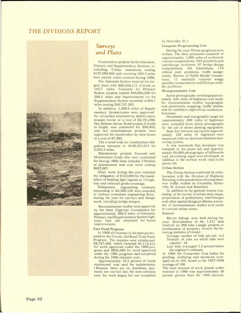
Surveys and Plans
Construction projects for the Interstate, Primary and Supplementary Systems, inincluding Urban extensions, costing $137,089,640 and covering 853.2 miles were placed under contract during 1966.
The Interstate System received the largest share with $69,358, 117 of work on 143.7 miles. Contracts for Primary System projects totaled $46,994,228 for 506.4 miles and improvements on the Supplementary System consisted of 203. 1 miles costing $20,737,295.
In addition, 1,200.6 miles of Supplementary System routes were approved for oil-surface treatment by district maintenance forces at a cost of $2,161,080. One Defense Access Road project, 0. 5 mile in length, was contracted for $99,505, and two miscellaneous projects were approved for construction by state forces at a cost of $7,392.
The overall total for construction obligations amounts to $139,357,617 for 2,054.3 miles.
Maintenance projects financed with Maintenance funds also were contracted for during 1966; these included 178miles of maintenance seal coat work costing $637,607.
Other work during the year included the obligation of $155,000 for the installation of flashing light signals at 14 highway and railroad grade crossings.
Preliminary engineering contracts amounting to $3,596,148 were awarded to various consultant engineering firms during the year for surveys and design work, including bridge designs.
Reconnaissance studies were approved by the State High .vay Commission for approximately 269.5 miles of Interstate, Primary and Supplementary System highways that are scheduled for future improvements.
Cart Fund Program In 1966 all counties in the state partici
pated in the County Aid Road Trust Fund Program. The counties were reimbursed $4,747,463, which included $4,113,414 for work approved under the 1966 program and $634,049 for work approved under the 1965 program and completed during the 1966 calendar year.
Approximately 73.5 percent of funds reimbursed was used for maintenance. ( Because there are no deadlines, payments are carried into the next calendar year for work begun but not completed
by December 31.)
Computer Programming Unit
During the year 95 new programs were written. The data processed consisted of approximately 1,066 miles of earthwork volume computations, 334 geometric and interchange problems, 97 bridge design computations, bid tabulations, 113 critical path problems, traffic assignments, Bureau of Public Roads' transactions, 11 asphaltic concrete wedge quantity computations and 35 slope stability problems. Photogrammetric Unit
Aerial photography covering approximately 450 miles of highways was made for reconnaissance studies, topographic and planimetric mapping, traffic studies and for exhibits in right of way condemnation cases.
Planimetric and topographic maps for approximately 200 miles of highways were compiled from aerial photographs by the use of stereo plotting equipment.
Base line traverse surveys for approximately 125 miles of highways were measured with an electronic distance measuring system.
A new automatic film developer was installed in the photo lab and approximately 60,000 photographs ofbillboards and advertising signs were developed, in addition to the normal work load in the photo lab. Urban Section
The Urban Section continued its collaboration with the Division of Highway Planning in the preparation of comprehensive traffic studies in Columbia, Kirksville, St. Joseph and Hannibal.
In addition to the general routine consisting of the review of urban strip maps, preparation of preliminary interchanges and other special design problems, anumber of reconnaissance studies were made in various urban areas.
General
Eleven lettings were held during the year. Examination of the 1,217 bids received on 268 jobs (single projects or combination of projects) reveals the following statistics of trends:
Average number of bids per job - 4.5 Number of jobs .on which bids were
rejected - 14 Low bids averaged 7.5 percent below
the engineer's estimate. In 1966 the Composite Cost Index for grading, surfacing and structures averaged out to 105, based on the 1957-1959 average of 100. The total amount of work placed under contract in 1966 was approximately 30 percent greater than the 1965 amount.

Bureau of Public Roau•
PLANKS beat the mud but weather and use soon made them worse than the ((rocky road to Dublin," as one Irishman put it.
Dancin' on a
Planl~
Road
~·-·
T he young folks figured it was a fittin' time for dancin'.
Their elders, most of them prominent citizens of Columbia and Boone county, had been plagued for six years by troublesome delays -legal, engineering and personal. Now the longawaited Providence plank road was completed. All ten miles of it. That included the mile and a half stretch of rock and gravel south out of Columbia toward Providence on the river. (The rock and gravel had been legalized that year for "plank" roads by the General Assembly, just in time for the dedication.)
Now it was July, 1855 and a crowd was gathered at the road's covered bridge over
CONTINUED
Page 33

. ~t - "~
~'"'
PLANK
Wooden roads lool~ed lil~e a godsend Hinkson creek south of Columbia to see - and hear - the official opening. No self-respecting road could be opened without oratory and the Providence plank road was no exception.
The crowd gathered in the cool shade of the wooden bridge to hear speeches by Colonel William Switzler, .M;ajor James Rollins and Robert Todd. Then the Rev. Nathan Hall offered a prayer. With the speechifying over, the young people took over the celebration with a dance on the bridge. Whereupon, one participant recalled, the dignified Presbyterian minister put on his stovepipe hat, picked up his cane and allowed as
Page 34
how it was time for him to leave. And leave he did.
For most Missourians of the mid-1800's the opening of a plank road was a time for dancing. Missouri roadbuilding had broken out in a cacophony of swishing crosscut saws, biting axes, falling timber and buzzing saw mills as a plank road mania swept the state.
Starting in 1849, and running about eight years through the administrations ofGovernors Austin King and Sterling Price, Missourians appear:ed intent on lacing the state with "corduroy roads." And with some logic.
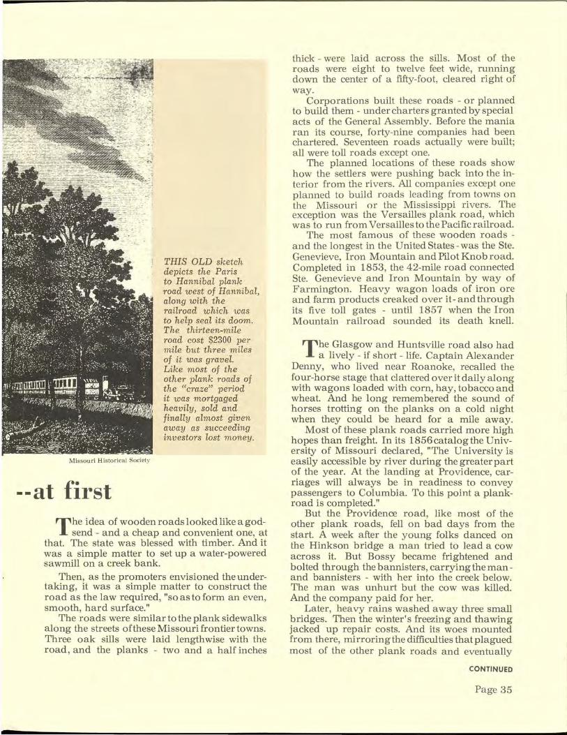
Missouri Historical Society
--at first
THIS OLD sketch depicts the Paris to Hannibal plank road west of Hannibal, along with the railroad w hich was to help seal its doom. The thirteen-mile road cost $2300 per mile but three miles of it was gravel. Like most of the other plank roads of the "craze" period it was mortgaged heavily, sold and finally almost given away as succeeding investors lost money.
The idea of wooden roads looked like a godsend - and a cheap and convenient one, at
that. The state was blessed with timber. And it was a simple matter to set up a water-powered sawmill on a creek bank.
Then, as the promoters envisioned the undertaking, it was a simple matter to construct the road as the law required, "so as to form an even, smooth, hard surface."
The roads were similar to the plank sidewalks along the streets of these Missouri frontier towns. Three oak sills were laid lengthwise with the road, and the planks - two and a half inches
thick - were laid across the sills. Most of the roads were eight to twelve feet wide, running down the center of a fifty-foot, cleared right of way.
Corporations built these roads - or planned to build them - under charters granted by special acts of the General Assembly. Before the mania ran its course, forty-nine companies had been chartered. Seventeen roads actually were built; all were toll roads except one.
The planned locations of these roads show how the settlers were pushing back into the interior from the rivers. All companies except one planned to build roads leading from towns on the Missouri or the Mississippi rivers. The exception was the Versailles plank road, which was to run from Versailles to the Pacific railroad.
The most famous of these wooden roads -and the longest in the United States- was the Ste. Genevieve, Iron Mountain and Pilot Knob road. Completed in 1853, the 42-mile road connected Ste. Genevieve and Iron Mountain by way of Farmington. Heavy wagon loads of iron ore and farm products creaked over it- and through its five toll gates - until 1857 when the Iron Mountain railroad sounded its death knell.
The Glasgow and Huntsville road also had a lively- if short- life. Captain Alexander
Denny, who lived near Roanoke, recalled the four-horse stage that clattered over it daily along with wagons loaded with corn, hay, tobacco and wheat. And he long remembered the sound of horses trotting on the planks on a cold night when they could be heard for a mile away.
Most of these plank roads carried more high hopes than freight. In its 1856catalogthe University of Missouri declared, "The University is easily accessible by river during the greater part of the year. At the landing at Providence, carriages will always be in readiness to convey passengers to Columbia. To this point a plankroad is completed."
But the Providence road, like most of the other plank roads, fell on bad days from the start. A week after the young folks danced on the Hinkson bridge a man tried to lead a cow across it. But Bossy became frightened and bolted through the bannisters, carrying the manand bannisters - with her into the creek below. The man was unhurt but the cow was killed. And the company paid for her.
Later, heavy rains washed away three small bridges. Then the winter's freezing and thawing jacked up repair costs. And its woes mounted from there, mirroring the difficulties that plagued most of the other plank roads and eventually
CONTINUED
Page 35
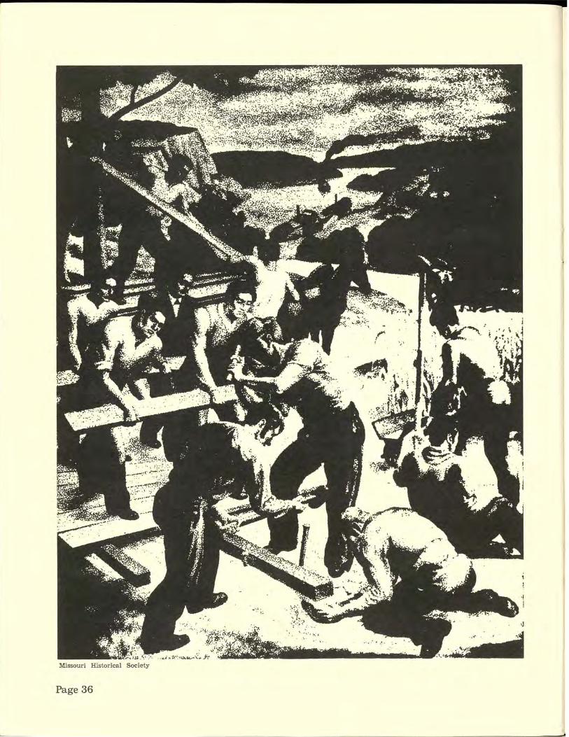
·, '·' J ,,

PLANK
rfhey whetted an appetite for better roads
dragged them down. Costs of the roads usually were more than
expected, receipts were less and operating expenses were higher. The contract price, for instance, on the thirteen miles of the HannibalParis road was $2300 per mile. On the Providence road it was $30,000 for ten miles.
F inally, despite loans from stockholders, the Providence road company could not pay
on its note. The deed of trust was foreclosed in August, 1857 and Milton Matthews and other
Missouri "".:::oLW:.,- . . Historical Society
stockholders bought it for $8700- two years and one month after the timbers of Hinkson creek bridge shook to the dancing feet of Boone county young folks. The owners, trying to fend off impending disaster, kept the road open.
But it and most of the other plank roads were doomed. The planks either sank into the mud to rot away or curled up like oaken pork rinds, making the ride, as Thomas Gentry of Columbia described it, ''like a ship riding the ocean waves."
Hastened by the coming of the railroads and
LAYING a plank road was a fast way to get out of the mud. But it also was a fast way to financial disaster to most investors.
stage lines and then the Civil War, the passing of the plank roads came swiftly.
The Providence road owners, for instance, finally cut tolls in half to try to save their investment. But it was too late. In desperation they sold it at auction to two enterprising Boone countians for $400. Tollhouses and lots were sold to other parties for $400. So the dancelaunched plank road which cost $30,000 plus another $5,000 for "extras" brought $800 across the auction block.
Then in 1865 the Boone County Court moved
to take over the road and in March, 1866 the owners surrendered all of their rights to the court. This was the last record concerning any plank road in Missouri.
The plank road mania was dead. On first judgement it had been a failure -an expensive failure for many individuals associated with it.
But time was to prove that plank roads were not a complete failure; they whetted the public's appetite for better roads, an appetite which was to hunger again after the bloom wore off the railroad boom.
Page 37

EADS' BRIDGE was a revolutionary undertaking, a marvel of engineering and aesthetic excellence, and it tamed the Mississippi River at St. Louis.
The 'finest expression of Page38

Ca pitol paintin g by Nudersche r
a civilization'
Early settlers needed
bridges to tame rivers
and conquer frontiers
" A bridge," someone said, "is thefinestexpression of a civilization."
That's a pretty sad commentary on the status of Missouri's frontier as a civilized society. But, then, people weren't flocking westward across the Mississippi in the early 1800's to find civilization; they were looking for land and a chance to build on it. Civilization? That could come later.
So when a river cut their westward march they crossed it - perhaps by uncivilized methods, but they crossed it. They forded it, swam it, floated down it and soggily went on their way. When settlements coagulated along these streams and the necessity for repeated crossings arose, these pioneers put their practical minds to the task of devising dry methods of crossing these waters.
Ferries offered a quick and cheap - and usually dry - method. Jean BaptisteGomachein 1776, the year that the Constitutional Convention delegates hammered out a Declaration of

EXPRESSION
Frugal settlers balli_ed at bridge taxes
Independence in a hot Philadelphia summer, concocted a Missouri frontier declaration of independence. At least it was such for travelers crossing the Meramec river on the Indian trail between St. Louis and Ste. Genevieve. His declaration was a ferry across the river south of St. Louis, the first officially recorded - and ordered- ferry in Missouri territory.
Gomache swapped his promised ferry operation for 1056 arpents of land. With that kind of
HEAVY TIMBERS in the early wooden bridges of Missouri gave way to steel in the late 1800's.
Page40
acreage (measurements varied with locales but an arpent was usually slightly more than an acre) he didn't need to worry about the ferry paying off. The Indians, in fact, displayed a marked unwillingness to pay the toll. Hostile, you might call them. So much so that Gomache closed down for a while until the free-riders cooled off.
Gamache's type of ferry- probably just boats - has been lost in antiquity. But some twenty

years later, in 1797, Captain James Piggott got fancy and lashed several pirogues together. He mounted a wooden platform on them and charged two dollars to carry a horse and driver across the Mississippi at St. Louis. That twodollar toll would seem to indicate that the frontier was becoming civilized fast!
Many other ferries sprang up as more settlers pushed into Missouri to stay. On
smaller streams these were usually boats, rowed or poled back and forth. Many of those early river-tamers bequeathed their names to roads and highways of today, like LeMay Ferry road ( a boat ride link across the Meramec on the King's Highway) and Hall's Ferry road ( named for a roofless flatboat arrangement, propelled at first by a horse-driven treadmill across the l'{I~ssouri in St. Louis county) .
But bridges had to come if man were to conquer Missouri's rivers and in the early 1800's came the first legislation about bridges. In 1814 the General Assembly of Missouri Territory passed a new public roads law which declared:
" ... All bridges or causeways made or to be made over small water courses, andcauseways, over swamps or low lands shall be made and kept in repair by the hands subject to work on the roads where the same may be necessary, and the materials wherewith the same shall be made, may be taken from any land the most convenient to such causeways or bridges, and shall be laid across the road, and be at least twelve feet long, well secured, and made fast, and covered with earth."
That was hardly a comprehensive bridge law but it was enough to start on. One of the first major bridge building jobs, however, was a military project. With the U.S. Army's Yellowstone Expedition headquartered at Council Bluffs on the upper Missouri, the military forces needed a road from the Boonslick country for movingup supplies during the winter when river traffic was iced in.
On September 2, 1819 Lieutenant Gabriel Fields rolled out of Council Bluffs with thirty men and a six-horse wagon tocuttheroadand bridge the streams. Fields' detachment reached the town of Chariton forty-seven days later and reported the road completed and all streams ( about sixty) bridged except the larger ones such as the Platte, the Nodaway, the Nishnabotna and the Grand.
On his return Fields tested the road and bridges by taking back one hundred and twentyseven milk cows and seven hundred stock hogs. Or, at least, the Missouri Intelligencer at Frank-
CONTINUED
RICKETY stilts
A PONTOON bridge
BUT it works

THE COVERED bridges were a hav en for birds and lovers-and the su bject of spooky stmies.
EXPRESSION
By the century's close few
wooden ones were being built
lin reported that he started out with that many animals.
By 1816 Moses Austin's town of Herculaneum had established itself as the lead
depot for that mining region. With the mining traffic a bridge was needed over Joachim creek so the General Assembly in 1828 granted toll bridge privileges there. The tolls, however, seemed a bit stiff to encourage its use - 6~ cents for a person, horse or mule; 2 cents per head of cattle; 1 cent per sheep or hog; 50 cents per wagon and team; 25 cents for cart and team; 7 5 cents for a riding carriage with four wheels and team; and 37 \.6 cents for a riding carriage with two wheels and a team.
During the 1840's and 1850's legislative grants of toll bridge privileges increased rapidly in all sections of the state except southwest Missouri and the Ozark highlands. But few were built.
These frugal - a nd not overly wealthy - M is-
Page 42
souri settlers did not want substantial b r idges if they meant substantial taxes or tolls. And bridge companies wouldn't invest their money until population and trade offered reasonable assurance of a profit.
In the 1850's, however, counties started building some hardy wooden bridges and in the next decade a county bridge tax was tacked permanently onto the county tax list. Also in this decade the use of iron and steel bridges reached the Midwest. In 1868 a steel bridge was built across the Grand River in Livingston county at a cost of $37,000. Two similar ones were erected during 1871 and by the close of the century few wooden bridges were being built.
The Missouri frontier and its settlers - and their bridges- perhaps couldn ' t be classed
as highly civilized. But these sometimes rambunctious pioneers recognized three powers to be bridled, or at least reckoned with. These were lightning, the ol' Mississippi and them blanketyblank Yankees. Sooner or later, they figured out a way to handle all three of them.
The Mississippi, its bank squatters declared, was a "contrarious varmint which couldn't be caged."
But the Eads bridge "caged" it - and raised the status of the fro a tier civilization a peg or two in the process. .
The Eads, the world's first steel-truss bridge, became the undisputed king of Missouri bridges in the pre-Twentieth Century period. The brainchild of Captain James Eads, it illustrates the capacity of a beautiful bridge to outshine its namesake and become a monument to itself.
Work on the bridge across the Mississippi started in 1867. Engineers questioned its long spans ( 530 feet in the center with two 502-foot side spans) and the use of steel. And ferry operators fought it as ridiculous competition.
Working in compressed air, and with little knowledge of its effects, 119 men developed "caisson disease" and fourteen of them died. But Eads persevered and, on July 4, 1874, the graceful, 6,200-foot bridge was dedicated after costing about $1 0 million.
Few ( some people say no) bridges built in Missouri after the Eads rivalled it for beauty and imaginative concept. But they were functional and fit frontier needs.
And as a recent television special report on bridges said in a burst of rare electronic wordcraft:
"Modern man is surrounded by great achievements that don't work very well - cities, the United Nations, plumbing.
"Bridges work."

They brought the need for roads--and for road laws
FOR MANY travelers the rough roads of Missouri carried them through the state to the "jU?npin' off" places, like Westport, seething with western fever.
CONTINUED
Page 43

LAWS
By 1310 the population
had almost doubled
to about 20~000 people
T he Frenchmen and Spaniards who took turns governing Upper Louisiana for their countries were little concerned with law
making- especially laws about roads which, for the most part, still were narrow Indian trails.
The Frenchmen were mainly interested in furs and mines. Coming from the acknowledged world capital of art and sophisticated culture, they surprisingly exhibited an unmatched diplomatic finesse in getting along with the so-called savage Indians. In fact, if the French had been able to handle the English with the skill and success that marked their Indian relations they would have won the New World hands down.
Under the Spanish officials after 1770 the laws and customs of Paris remained in vogue. Spanish was the official language and Spanish titles were substituted for the French. But many Frenchmen were appointed to offices and French, the native language of the inhabitants, was spoken widely. The Spanish regime was respected for its well-selected officials and impartial law enforcement but its new laws mainly concerned the acquisition of lands and regulation of inheritances.
When the Americans bought the whole hunk of real estate it was put under the Territory of Indiana. But in 1805 Congress set up the Louisiana District with its own government. President Thomas Jefferson appointed a governor, a secretary and a legislature, composed of the governor and three judges. General James Wilkinson was the first governor but his administration aroused the ire of the rough frontiersmen and in 1807 he was replaced by Meriwether Lewis, only one year returned from his expedition with Clark to the Pacific ocean.
During the Spanish rule no great need for roads existed; the lead mines were linked to the river and the four military posts strung along the western bank were tied- if loosely- together
Page 44
THE FIRST legislature, meeting at St. Charles, faced many problems, including the growing need for roads.
,-
.. ~,~~_,_-.~
~- ' J. _./
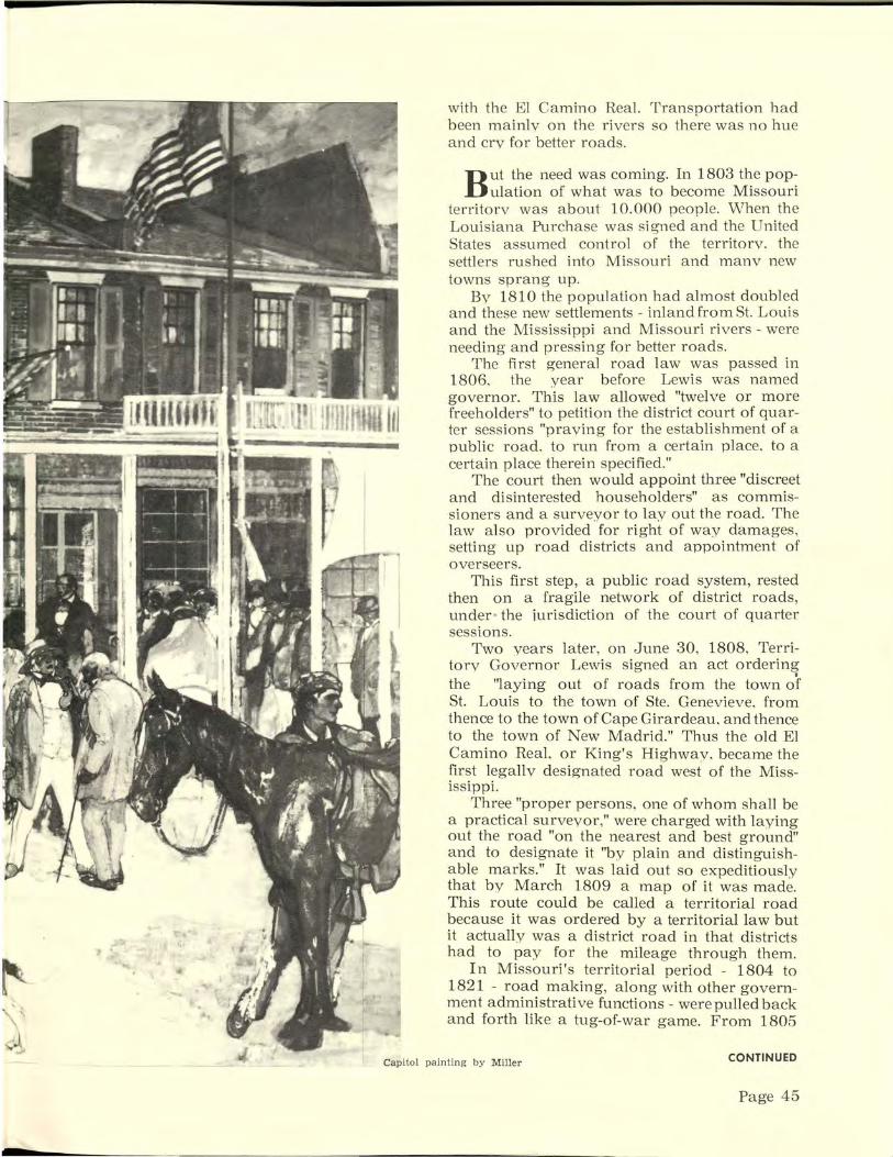
't
... '~
with the El Camino Real. Transportation had been mainly on the rivers so there was no hue and cry for better roads.
But the need was coming. In 1803 the population of what was to become Missouri
territory was about 10.000 people. \\lhen the Louisiana Purchase was signed and the United States assumed control of the territory. the settlers rushed into Missouri and manv new towns sprang up.
By 1810 the population had almost doubled and these new settlements - inland from St. Louis and the Mississippi and Missouri rivers - were needing and pressing for better roads.
The first general road law was passed in 1806. the year before Lewis was named governor. This law allowed "twelve or more freeholders" to petition the district court of quarter sessions "praying for the establishment of a public road. to run from a certain place. to a certain place therein specified."
The court then would appoint three "discreet and disinterested householders" as commissioners and a surveyor to lay out the road. The law also provided for right of way damages, setting up road districts and appointment of overseers.
This first step, a public road system, rested then on a fragile network of district roads, under- the jurisdiction of the court of quarter sessions.
Two years later, on June 30, 1808, Territory Governor Lewis signed an act ordering the ''laying out of roads from the town of St. Louis to the town of Ste. Genevieve, from thence to the town of Cape Girardeau. and thence to the town of New Madrid." Thus the old El Camino ReaL or King's Highway, became the first legally designated road west of the Mississippi.
Three "proper persons, one of whom shall be a practical surveyor," were charged with laying out the road "on the nearest and best ground" and to designate it "by plain and distinguishable marks." It was laid out so expeditiously that by March 1809 a map of it was made. This route could be called a territorial road because it was ordered by a territorial law but it actually was a district road in that districts had to pay for the mileage through them.
In Missouri's territorial period - 1804 to 1821 - road making, along with other government administrative functions- were pulled back and forth like a tug-of-war game. From 1805
Capitol painting by Miller CONTINUED
Page 45
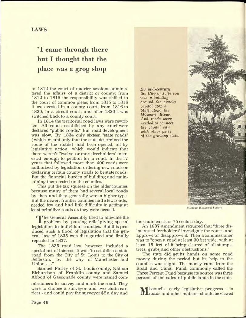
LAWS
" I came through there
but I thought that the
place was a grog shop
to 1812 the court of quarter sessions administered the affairs of a district or county; from 1812 to 1815 the responsibility was shifted to the court of common pleas; from 1815 to 1816 it was vested in a county court; from 1816 to 1820, in a circuit court; and after 1820 it was switched back to a county court.
In 1814 the territorial road laws were rewritten. All roads established by any court were declared "public roads." But road development was slow. By 1834 only sixteen "state roads" (which meant only that the state determined the route of the roads) had been opened, all by legislative action, which would indicate that there weren't "twelve or more freeholders" interested enough to petition for a road. In the 17 years that followed more than 400 roads were authorized by legislation ordering new roads or declaring certain county roads to be state roads. But the financial burden of building and maintaining them rested on the counties.
This put the tax squeeze on the older counties because many of them had several local roads by then and they generally were a higher type. But the newer, frontier counties had a few roads, needed few and had little difficulty in getting at least primitive roads as they were needed.
T he General Assembly tried to alleviate the problem by passing relief-giving special
legislation to individual counties. But this produced such a flood of legislation that the general law of 1835 was disregarded and finally repealed in 1837.
The 1835 road law, however, included a special act of interest. It was "to establish a state road from the City of St. Louis to the City of Jefferson, by the way of Manchester and Union ... "
Samuel Farley of St. Louis county, Nathan Richardson of Franklin county and Samuel Abbott of Gasconade county were named com-
missioners to survey and mark the road. They were to choose a surveyor and two chain carriers - and could pay the surveyor $2 a day and
Page 46
By mid-century the City of Jefferson was a-building around the stately capitol atop a bluff along the Missouri River. And roads were needed to connect the capital city wi~h other parts of the growing state.
Missouri Histo rical Society
the chain carriers 7 5 cents a day. An 1837 amendment required that "three dis
interested freeholders" investigate the route -and approve or disapprove it. Then a commissioner was to "open a road at least 30 feet wide, with at least 15 feet of it being cleared of all stumps, trees, grubs and other obstructions."
The state did get its hands on some road money during the period but its help to the counties was slight. The money came from the Road and Canal Fund, commonly called the Three Percent Fund because its source was three percent of the sales of public lands in the state.
Missouri's early legislative progress - in roads and other matters- should be viewed
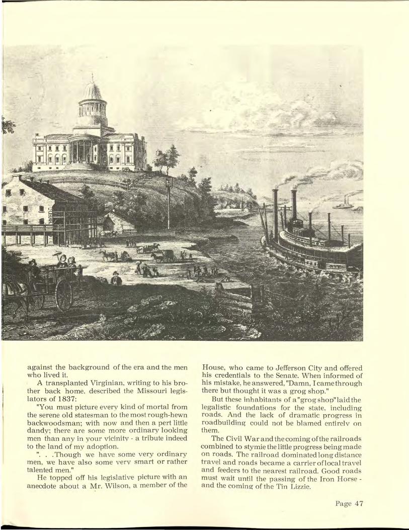
j
1
against the background of the era and the men who lived it.
A transplanted Virginian, writing to his brother back home, described the Missouri legislators of 1837:
"You must picture every kind of mortal from the serene old statesman to the most rough-hewn backwoodsman; with now and then a pert little dandy; there are some more ordinary looking men than any in your vicinity- a tribute indeed to the land of my adoption.
". . . Though we have some very ordinary men, we have also some very smart or rather talented men."
He topped off his legislative picture with an anecdote about a Mr. Wilson, a member of the
House, who came to Jefferson City and offered his credentials to the Senate. When informed of his mistake, he answered, "Damn, Icamethrough there but thought it was a grog shop."
But these inhabitants of a "grog shop" laid the legalistic foundations for the state, including roads. And the lack of dramatic progress in roadbuilding could not be blamed entirelv on them.
The Civil War and the coming of the railroads combined to stymie the little progress being made on roads. The railroad dominated long distance travel and roads became a carrier oflocal travel and feeders to the nearest railroad. Good roads must wait until the passing of the Iron Horse -and the coming of the Tin Lizzie.
Page 47

Then came the Tin Lizzie Bureau of Public Roads
and a new era for Missouri and its highways
Page 48

Published by
MISSOURI STATE HIGHWAY COMMISSION
Prepared and designed by
DIVISION OF PUBLIC INFORMATION
G. M. Threlkeld, Director