![Bahar-e-Shariat (Part 11) [Urdu Book]](https://static.fdocuments.us/doc/165x107/586b7fa41a28abf6518b5ffb/bahar-e-shariat-part-11-urdu-book.jpg)
The Evaluation of Municipal Landfill Sites in North of...
7
Journal of Environmental Protection, 2013, 4, 811-817 http://dx.doi.org/10.4236/jep.2013.48095 Published Online August 2013 (http://www.scirp.org/journal/jep) 811 The Evaluation of Municipal Landfill Sites in North of Iran through Comparing BC Guideline and Iran Legislation Mohadeseh Yazdani 1 , Masoud Monavari 1 , Ghasem Ali Omrani 2 , Mahmoud Shariat 2 , Mohsen Hosseini 3 1 Department of Environmental Science, Graduate School of Environment and Energy, Science and Research Campus, Islamic Azad University, Tehran, Iran; 2 Tehran University of Medical Sciences, School of Public Health, Tehran, Iran; 3 Department of Forestry, Faculty of Natural Resources, Tarbiat Modares University, Noor, Iran. Email: [email protected], [email protected], [email protected], [email protected], [email protected] Received May 1 st , 2013; revised June 8 th , 2013; accepted June 28 th , 2013 Copyright © 2013 Mohadeseh Yazdani et al. This is an open access article distributed under the Creative Commons Attribution Li- cense, which permits unrestricted use, distribution, and reproduction in any medium, provided the original work is properly cited. ABSTRACT Selection of landfill site is a complex process which demands many diverse criteria. The significance of the present study lies in the fact that it tends to evaluate the suitability of the existing municipal landfill sites in the west area of Mazandaran province, located in north of Iran, and the south coast of Caspian Sea. In order to carry out this evaluation, 3 guidelines are used. After reviewing all the specified criteria in each of the guidelines, the authenticity of each deposit site of the study area and the entire area also was examined; and eventually the appropriate areas were identified. As a result, 62.38 percent of the study area according to the guideline of British Columbia, 25 percent according to the Iran department of environment, and the 48.5 percent according to the management and planning organization of Iran are suitable for landfill siting. Keywords: Landfill Siting; Evaluation; Siting Criteria; BC; DOE; MPO 1. Introduction In developing countries, in spite of the increasing stress toward the waste reduction at the source, the disposal of landfilling has remained the most commonly employed method. Landfill sitting is a complex process, for which various techniques have been developed [1,2]. These techniques, through using multiple factors, attempt to reduce negative effects on environment. In landfill siting, in order to reduce negative impacts on the environment, a wide range of territorial and legal factors should take into account [3]. The development of a municipal solid waste landfill requires the acquisition of large tracts of land and their suitable siting in a pre-existing urban matrix, comprised of diverse competing land uses [4]. The site selection procedure, however, should make maximum use of the available information and ensure that the outcome of the process is acceptable by most stakeholders. Therefore, landfill siting generally requires the processing of a vari- ety of spatial data [5]. GIS plays a significant role in sit- ing landfills. The potential advantage of a GIS-based approach to siting arises from the fact that it not only reduces the time and cost of site selection but also pro- vides a digital data bank for long-term monitoring of the site [6]. The truth that the municipal solid waste man- agement in Iran is in critical conditions, is not a secret [7]. Unfortunately in most cities of Iran, even the simplest method of waste disposal landfill does not apply [8]. Despite the increasing advances in modern methods of locating waste landfills in the world, unfortunately, 49 percent of the total solid waste disposal methods in Iran is piled up and unsafe for disposal [9]. There are so many problems associated with the landfill sites across the country, and there is no exception in this province as well. The problems include open-air waste burning, open-pit dumping and uncontrolled waste disposal in landfills, which can result in negative impacts on public health and on environment [10-12]. The west area of Mazandaran, due to its topographic conditions (forest and sea close together), its high groundwater levels, its high tourist population (especially in spring &summer) has more critical status than the other parts of the province. 2. Area of Study The studied area measures 8761.5 km 2 , and is located in the west of the province of Mazandaran on the Northern Copyright © 2013 SciRes. JEP
Transcript of The Evaluation of Municipal Landfill Sites in North of...

Journal of Environmental Protection, 2013, 4, 811-817 http://dx.doi.org/10.4236/jep.2013.48095 Published Online August 2013 (http://www.scirp.org/journal/jep)
811
The Evaluation of Municipal Landfill Sites in North of Iran through Comparing BC Guideline and Iran Legislation
Mohadeseh Yazdani1, Masoud Monavari1, Ghasem Ali Omrani2, Mahmoud Shariat2, Mohsen Hosseini3
1Department of Environmental Science, Graduate School of Environment and Energy, Science and Research Campus, Islamic Azad University, Tehran, Iran; 2Tehran University of Medical Sciences, School of Public Health, Tehran, Iran; 3Department of Forestry, Faculty of Natural Resources, Tarbiat Modares University, Noor, Iran. Email: [email protected], [email protected], [email protected], [email protected],
[email protected] Received May 1st, 2013; revised June 8th, 2013; accepted June 28th, 2013 Copyright © 2013 Mohadeseh Yazdani et al. This is an open access article distributed under the Creative Commons Attribution Li-cense, which permits unrestricted use, distribution, and reproduction in any medium, provided the original work is properly cited.
ABSTRACT
Selection of landfill site is a complex process which demands many diverse criteria. The significance of the present study lies in the fact that it tends to evaluate the suitability of the existing municipal landfill sites in the west area of Mazandaran province, located in north of Iran, and the south coast of Caspian Sea. In order to carry out this evaluation, 3 guidelines are used. After reviewing all the specified criteria in each of the guidelines, the authenticity of each deposit site of the study area and the entire area also was examined; and eventually the appropriate areas were identified. As a result, 62.38 percent of the study area according to the guideline of British Columbia, 25 percent according to the Iran department of environment, and the 48.5 percent according to the management and planning organization of Iran are suitable for landfill siting. Keywords: Landfill Siting; Evaluation; Siting Criteria; BC; DOE; MPO
1. Introduction
In developing countries, in spite of the increasing stress toward the waste reduction at the source, the disposal of landfilling has remained the most commonly employed method. Landfill sitting is a complex process, for which various techniques have been developed [1,2]. These techniques, through using multiple factors, attempt to reduce negative effects on environment. In landfill siting, in order to reduce negative impacts on the environment, a wide range of territorial and legal factors should take into account [3].
The development of a municipal solid waste landfill requires the acquisition of large tracts of land and their suitable siting in a pre-existing urban matrix, comprised of diverse competing land uses [4]. The site selection procedure, however, should make maximum use of the available information and ensure that the outcome of the process is acceptable by most stakeholders. Therefore, landfill siting generally requires the processing of a vari-ety of spatial data [5]. GIS plays a significant role in sit-ing landfills. The potential advantage of a GIS-based approach to siting arises from the fact that it not only reduces the time and cost of site selection but also pro-
vides a digital data bank for long-term monitoring of the site [6]. The truth that the municipal solid waste man-agement in Iran is in critical conditions, is not a secret [7]. Unfortunately in most cities of Iran, even the simplest method of waste disposal landfill does not apply [8]. Despite the increasing advances in modern methods of locating waste landfills in the world, unfortunately, 49 percent of the total solid waste disposal methods in Iran is piled up and unsafe for disposal [9]. There are so many problems associated with the landfill sites across the country, and there is no exception in this province as well. The problems include open-air waste burning, open-pit dumping and uncontrolled waste disposal in landfills, which can result in negative impacts on public health and on environment [10-12]. The west area of Mazandaran, due to its topographic conditions (forest and sea close together), its high groundwater levels, its high tourist population (especially in spring &summer) has more critical status than the other parts of the province.
2. Area of Study
The studied area measures 8761.5 km2, and is located in the west of the province of Mazandaran on the Northern
Copyright © 2013 SciRes. JEP
The Evaluation of Municipal Landfill Sites in North of Iran through Comparing BC Guideline and Iran Legislation 812
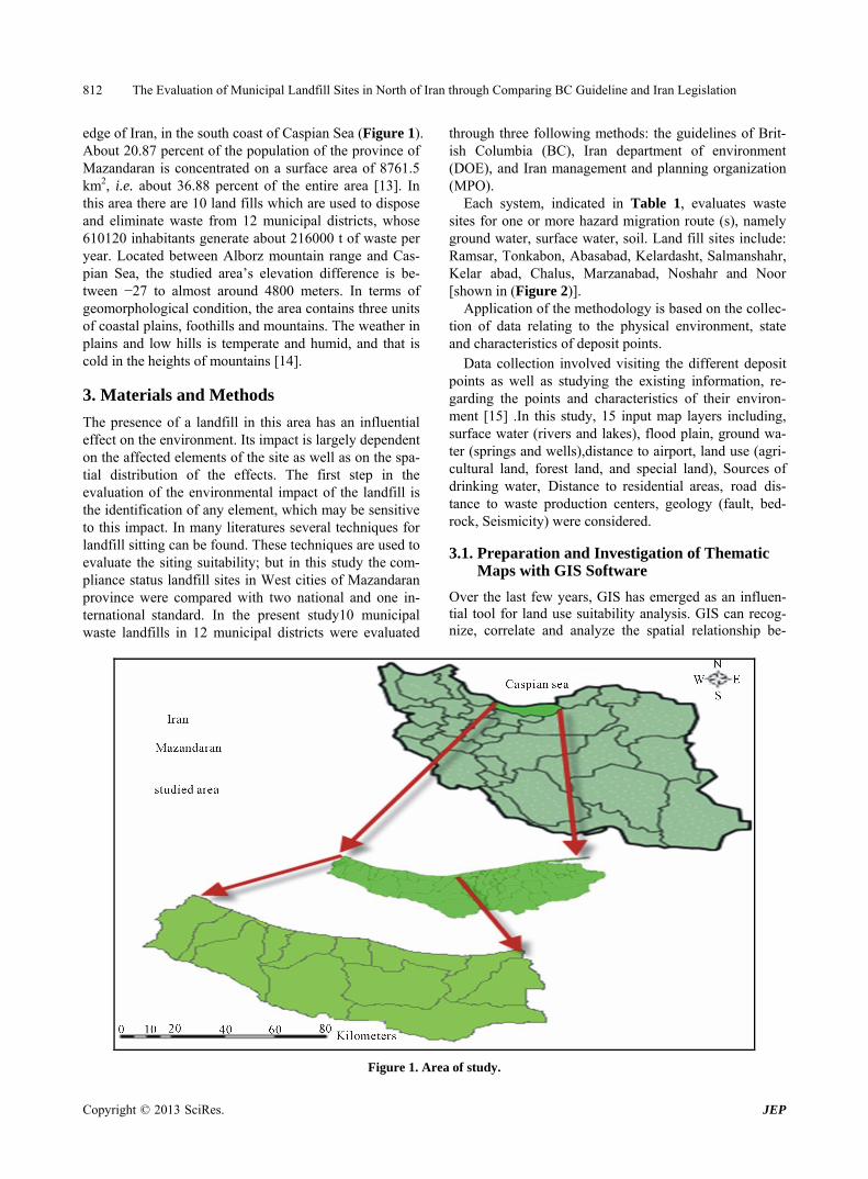
edge of Iran, in the south coast of Caspian Sea (Figure 1). About 20.87 percent of the population of the province of Mazandaran is concentrated on a surface area of 8761.5 km2, i.e. about 36.88 percent of the entire area [13]. In this area there are 10 land fills which are used to dispose and eliminate waste from 12 municipal districts, whose 610120 inhabitants generate about 216000 t of waste per year. Located between Alborz mountain range and Cas- pian Sea, the studied area’s elevation difference is be- tween −27 to almost around 4800 meters. In terms of geomorphological condition, the area contains three units of coastal plains, foothills and mountains. The weather in plains and low hills is temperate and humid, and that is cold in the heights of mountains [14].
3. Materials and Methods
The presence of a landfill in this area has an influential effect on the environment. Its impact is largely dependent on the affected elements of the site as well as on the spa-tial distribution of the effects. The first step in the evaluation of the environmental impact of the landfill is the identification of any element, which may be sensitive to this impact. In many literatures several techniques for landfill sitting can be found. These techniques are used to evaluate the siting suitability; but in this study the com- pliance status landfill sites in West cities of Mazandaran province were compared with two national and one in- ternational standard. In the present study10 municipal waste landfills in 12 municipal districts were evaluated
through three following methods: the guidelines of Brit- ish Columbia (BC), Iran department of environment (DOE), and Iran management and planning organization (MPO).
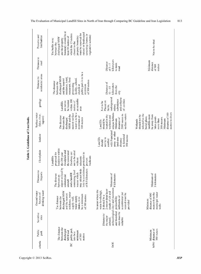
Each system, indicated in Table 1, evaluates waste sites for one or more hazard migration route (s), namely ground water, surface water, soil. Land fill sites include: Ramsar, Tonkabon, Abasabad, Kelardasht, Salmanshahr, Kelar abad, Chalus, Marzanabad, Noshahr and Noor [shown in (Figure 2)].
Application of the methodology is based on the collec- tion of data relating to the physical environment, state and characteristics of deposit points.
Data collection involved visiting the different deposit points as well as studying the existing information, re- garding the points and characteristics of their environ- ment [15] .In this study, 15 input map layers including, surface water (rivers and lakes), flood plain, ground wa- ter (springs and wells),distance to airport, land use (agri- cultural land, forest land, and special land), Sources of drinking water, Distance to residential areas, road dis- tance to waste production centers, geology (fault, bed- rock, Seismicity) were considered.
3.1. Preparation and Investigation of Thematic Maps with GIS Software
Over the last few years, GIS has emerged as an influen-tial tool for land use suitability analysis. GIS can recog-nize, correlate and analyze the spatial relationship be-
Figure 1. Area of study.
Copyright © 2013 SciRes. JEP
The Evaluation of Municipal Landfill Sites in North of Iran through Comparing BC Guideline and Iran Legislation 813
Copyright © 2013 SciRes. JEP

The Evaluation of Municipal Landfill Sites in North of Iran through Comparing BC Guideline and Iran Legislation
Copyright © 2013 SciRes. JEP
814
Figure 2. Location of landfill sites. tween mapped phenomena, thereby enabling policy- makers to link disparate sources of information, toper-form sophisticated analysis, to visualize trends and pro-ject outcomes, and also to strategize long-term planning goals [16].
The landfill sites map layer is prepared by locating the GPS coordinates of landfill sites and entering them as latitude and longitude in the GIS software database, and then converting them into the point data. Buffer maps indicating regions encompassing appropriate areas from lakes, rivers, water supply sources, protected area, high-ways and fault line were also generated to act as ‘areas of constraints’, i.e., where a landfill can not be sited.
3.1.1. Evaluation Criteria Surface water (Hydrology) map:
Surface water map indicates the existing lakes, wet-land and rivers in the studied area. Because of the spe-cific conditions of climate, there are multiple rivers around twenty main rivers and a lake, Valasht, in this area. Road network map:
The road network map delineates the national high-ways and other major roads of the studied area. There are seven (7) major roads and 21 (twenty one) highways in the region. Land use map:
The land use map displays the land utilized by human or the natural cover in the region. Relatively dense forest zone (Hyrcanian forest) covers most of the land surface
in the studied area. Ground water source(Hydrogeology) map:
This map displays the wells and springs in this area; there are 20592 wells and 166 springs in the studied area. Residential areas map:
This map displays the existing cities and villages; there are 18 cities and around 1198 villages in the studied area. Geology map:
This map shows that Shemshak formation is the most geological unit in the studied area, and its typicality is alternating coal-bearing sandstone and shale. Sensitive sites map:
This map layer displays the cultural and historical and archaeological area, these sites are exempted from land-fill siting and they have a safe distance. protected area sites map:
The map displays the protected areas, under the man-agement of the Department of the Environment (DOE), which are around 39% of the studied area. Flood plain map:
This map shows that 210.5 km equivalent to about 2.4 percent of studied area is at risk of flooding. Infiltration Map :
An infiltration map displays the various soil types ex-isting in the studied are. The infiltration rate is an impor-tant determinant in assessing the potential risk of con-tamination groundwater and thus is a major criterion for the development of landfill in the study area. We use this map to estimation of ground water level and soil type in this area.
The Evaluation of Municipal Landfill Sites in North of Iran through Comparing BC Guideline and Iran Legislation 815
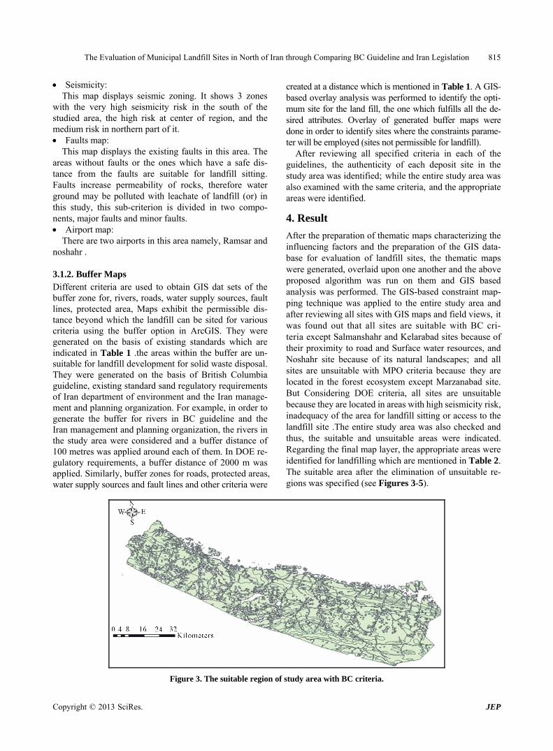
Seismicity: This map displays seismic zoning. It shows 3 zones
with the very high seismicity risk in the south of the studied area, the high risk at center of region, and the medium risk in northern part of it. Faults map:
This map displays the existing faults in this area. The areas without faults or the ones which have a safe dis-tance from the faults are suitable for landfill sitting. Faults increase permeability of rocks, therefore water ground may be polluted with leachate of landfill (or) in this study, this sub-criterion is divided in two compo-nents, major faults and minor faults. Airport map:
There are two airports in this area namely, Ramsar and noshahr .
3.1.2. Buffer Maps Different criteria are used to obtain GIS dat sets of the buffer zone for, rivers, roads, water supply sources, fault lines, protected area, Maps exhibit the permissible dis-tance beyond which the landfill can be sited for various criteria using the buffer option in ArcGIS. They were generated on the basis of existing standards which are indicated in Table 1 .the areas within the buffer are un-suitable for landfill development for solid waste disposal. They were generated on the basis of British Columbia guideline, existing standard sand regulatory requirements of Iran department of environment and the Iran manage-ment and planning organization. For example, in order to generate the buffer for rivers in BC guideline and the Iran management and planning organization, the rivers in the study area were considered and a buffer distance of 100 metres was applied around each of them. In DOE re- gulatory requirements, a buffer distance of 2000 m was applied. Similarly, buffer zones for roads, protected areas, water supply sources and fault lines and other criteria were
created at a distance which is mentioned in Table 1. A GIS- based overlay analysis was performed to identify the opti- mum site for the land fill, the one which fulfills all the de-sired attributes. Overlay of generated buffer maps were done in order to identify sites where the constraints parame-ter will be employed (sites not permissible for landfill).
After reviewing all specified criteria in each of the guidelines, the authenticity of each deposit site in the study area was identified; while the entire study area was also examined with the same criteria, and the appropriate areas were identified.
4. Result
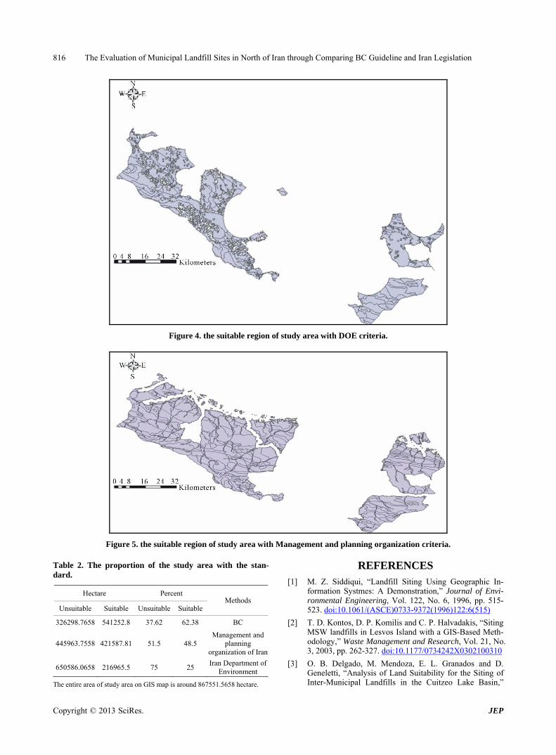
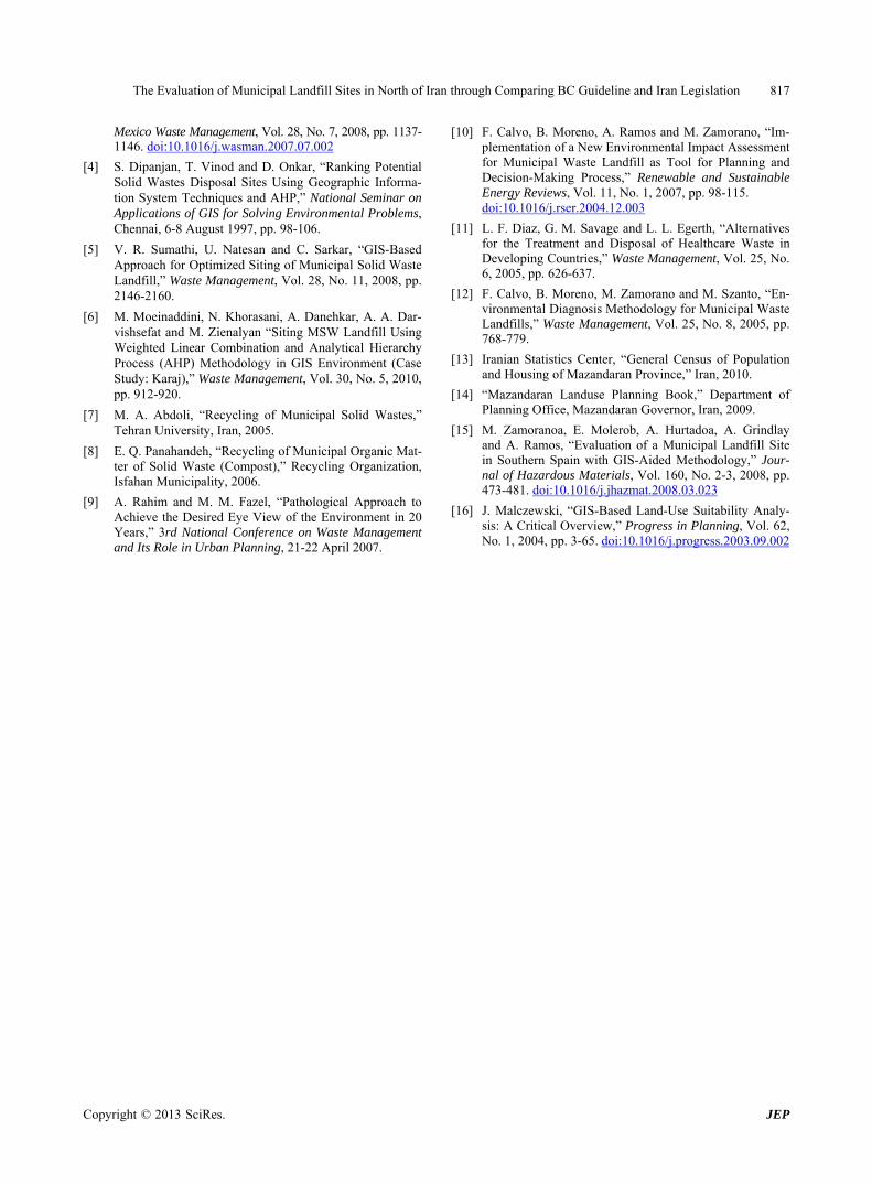
After the preparation of thematic maps characterizing the influencing factors and the preparation of the GIS data-base for evaluation of landfill sites, the thematic maps were generated, overlaid upon one another and the above proposed algorithm was run on them and GIS based analysis was performed. The GIS-based constraint map-ping technique was applied to the entire study area and after reviewing all sites with GIS maps and field views, it was found out that all sites are suitable with BC cri- teria except Salmanshahr and Kelarabad sites because of their proximity to road and Surface water resources, and Noshahr site because of its natural landscapes; and all sites are unsuitable with MPO criteria because they are located in the forest ecosystem except Marzanabad site. But Considering DOE criteria, all sites are unsuitable because they are located in areas with high seismicity risk, inadequacy of the area for landfill sitting or access to the landfill site .The entire study area was also checked and thus, the suitable and unsuitable areas were indicated. Regarding the final map layer, the appropriate areas were identified for landfilling which are mentioned in Table 2. The suitable area after the elimination of unsuitable re-gions was specified (see Figures 3-5).
Figure 3. The suitable region of study area with BC criteria.
Copyright © 2013 SciRes. JEP
The Evaluation of Municipal Landfill Sites in North of Iran through Comparing BC Guideline and Iran Legislation 816
Figure 4. the suitable region of study area with DOE criteria.
Figure 5. the suitable region of study area with Management and planning organization criteria. Table 2. The proportion of the study area with the stan-dard.
Hectare Percent Unsuitable Suitable Unsuitable Suitable
Methods
326298.7658 541252.8 37.62 62.38 BC
445963.7558 421587.81 51.5 48.5 Management and
planning organization of Iran
650586.0658 216965.5 75 25 Iran Department of
Environment
The entire area of study area on GIS map is around 867551.5658 hectare.
REFERENCES [1] M. Z. Siddiqui, “Landfill Siting Using Geographic In-
formation Systmes: A Demonstration,” Journal of Envi- ronmental Engineering, Vol. 122, No. 6, 1996, pp. 515- 523. doi:10.1061/(ASCE)0733-9372(1996)122:6(515)
[2] T. D. Kontos, D. P. Komilis and C. P. Halvadakis, “Siting MSW landfills in Lesvos Island with a GIS-Based Meth- odology,” Waste Management and Research, Vol. 21, No. 3, 2003, pp. 262-327. doi:10.1177/0734242X0302100310
[3] O. B. Delgado, M. Mendoza, E. L. Granados and D. Geneletti, “Analysis of Land Suitability for the Siting of Inter-Municipal Landfills in the Cuitzeo Lake Basin,”
Copyright © 2013 SciRes. JEP
The Evaluation of Municipal Landfill Sites in North of Iran through Comparing BC Guideline and Iran Legislation 817
Mexico Waste Management, Vol. 28, No. 7, 2008, pp. 1137- 1146. doi:10.1016/j.wasman.2007.07.002
[4] S. Dipanjan, T. Vinod and D. Onkar, “Ranking Potential Solid Wastes Disposal Sites Using Geographic Informa- tion System Techniques and AHP,” National Seminar on Applications of GIS for Solving Environmental Problems, Chennai, 6-8 August 1997, pp. 98-106.
[5] V. R. Sumathi, U. Natesan and C. Sarkar, “GIS-Based Approach for Optimized Siting of Municipal Solid Waste Landfill,” Waste Management, Vol. 28, No. 11, 2008, pp. 2146-2160.
[6] M. Moeinaddini, N. Khorasani, A. Danehkar, A. A. Dar- vishsefat and M. Zienalyan “Siting MSW Landfill Using Weighted Linear Combination and Analytical Hierarchy Process (AHP) Methodology in GIS Environment (Case Study: Karaj),” Waste Management, Vol. 30, No. 5, 2010, pp. 912-920.
[7] M. A. Abdoli, “Recycling of Municipal Solid Wastes,” Tehran University, Iran, 2005.
[8] E. Q. Panahandeh, “Recycling of Municipal Organic Mat- ter of Solid Waste (Compost),” Recycling Organization, Isfahan Municipality, 2006.
[9] A. Rahim and M. M. Fazel, “Pathological Approach to Achieve the Desired Eye View of the Environment in 20 Years,” 3rd National Conference on Waste Management and Its Role in Urban Planning, 21-22 April 2007.
[10] F. Calvo, B. Moreno, A. Ramos and M. Zamorano, “Im- plementation of a New Environmental Impact Assessment for Municipal Waste Landfill as Tool for Planning and Decision-Making Process,” Renewable and Sustainable Energy Reviews, Vol. 11, No. 1, 2007, pp. 98-115. doi:10.1016/j.rser.2004.12.003
[11] L. F. Diaz, G. M. Savage and L. L. Egerth, “Alternatives for the Treatment and Disposal of Healthcare Waste in Developing Countries,” Waste Management, Vol. 25, No. 6, 2005, pp. 626-637.
[12] F. Calvo, B. Moreno, M. Zamorano and M. Szanto, “En- vironmental Diagnosis Methodology for Municipal Waste Landfills,” Waste Management, Vol. 25, No. 8, 2005, pp. 768-779.
[13] Iranian Statistics Center, “General Census of Population and Housing of Mazandaran Province,” Iran, 2010.
[14] “Mazandaran Landuse Planning Book,” Department of Planning Office, Mazandaran Governor, Iran, 2009.
[15] M. Zamoranoa, E. Molerob, A. Hurtadoa, A. Grindlay and A. Ramos, “Evaluation of a Municipal Landfill Site in Southern Spain with GIS-Aided Methodology,” Jour- nal of Hazardous Materials, Vol. 160, No. 2-3, 2008, pp. 473-481. doi:10.1016/j.jhazmat.2008.03.023
[16] J. Malczewski, “GIS-Based Land-Use Suitability Analy- sis: A Critical Overview,” Progress in Planning, Vol. 62, No. 1, 2004, pp. 3-65. doi:10.1016/j.progress.2003.09.002
Copyright © 2013 SciRes. JEP


![Bahar-e-Shariat 1: Imaan [English]](https://static.fdocuments.us/doc/165x107/55cf9744550346d03390a80a/bahar-e-shariat-1-imaan-english.jpg)