THE ESTONIAN UNIVERSITY OF LIFE SCIENCES - baltic … · the estonian university of life sciences...
89
Transcript of THE ESTONIAN UNIVERSITY OF LIFE SCIENCES - baltic … · the estonian university of life sciences...

THE ESTONIAN UNIVERSITY OF LIFE SCIENCES
Tallinn, 2011
THE ESTONIAN GREEN BELTKalev Sepp, editor
This project is part-financed by the European Union (ERDF)

This publication was prepared within the Baltic Green Belt project (www.balticgreenbelt.net) which is part-financed by the European Union (European Regional Development Fund) within the Baltic Sea Region Programme
CONTENTSINTRODUCTION � � � � � � � � � � � � � � � � � � � � � � � � � � � � � � � � � � � � � � � � � � � � � � � � � � � � � � � � � � � � � � � � � � � � � � � � � � � � � � � � 7
CHAPTER 1 � � � � � � � � � � � � � � � � � � � � � � � � � � � � � � � � � � � � � � � � � � � � � � � � � � � � � � � � � � � � � � � � � � � � � � � � � � � � � � � � � � � � � 12
RESTRICTED ACCESS BORDER ZONES OF THE ESTONIAN SOVIET SOCIALIST REPUBLIC � � � � � � � � � � � � 12
DEFINING ESTONIA’S MILITARY GREEN BELT AND MILITARY HERITAGE � � � � � � � � � � � � � � � � � � � � � � � � � � � � � � � 12
CHAPTER 2 � � � � � � � � � � � � � � � � � � � � � � � � � � � � � � � � � � � � � � � � � � � � � � � � � � � � � � � � � � � � � � � � � � � � � � � � � � � � � � � � � � � � � 15
SOVIET MILITARY INFRASTRUCTURE AND ITS FORMATION IN ESTONIA � � � � � � � � � � � � � � � � � � � � � � � � � � 15
MILITARY HERITAGE � � � � � � � � � � � � � � � � � � � � � � � � � � � � � � � � � � � � � � � � � � � � � � � � � � � � � � � � � � � � � � � � � � � � � � � � � � � 15
MANPOWER LEVELS OF THE SOVIET ARMED FORCES IN ESTONIA 1944-1994 � � � � � � � � � � � � � � � � � � � � � � � � � 17
METHODS AND MATERIALS USED IN THE CONSTRUCTION OF MILITARY INFRASTRUCTURE OBJECTS � � � 21
COASTAL ARTILLERY BATTERIES � � � � � � � � � � � � � � � � � � � � � � � � � � � � � � � � � � � � � � � � � � � � � � � � � � � � � � � � � � � � � � � � � 22
HYDROGRAPHY � � � � � � � � � � � � � � � � � � � � � � � � � � � � � � � � � � � � � � � � � � � � � � � � � � � � � � � � � � � � � � � � � � � � � � � � � � � � � � 22
PRISONER-OF-WAR CAMPS � � � � � � � � � � � � � � � � � � � � � � � � � � � � � � � � � � � � � � � � � � � � � � � � � � � � � � � � � � � � � � � � � � � � 23
RAILROADS ON SAAREMAA ISLAND � � � � � � � � � � � � � � � � � � � � � � � � � � � � � � � � � � � � � � � � � � � � � � � � � � � � � � � � � � � � � 23
HIGHWAYS ON HIIUMAA ISLAND � � � � � � � � � � � � � � � � � � � � � � � � � � � � � � � � � � � � � � � � � � � � � � � � � � � � � � � � � � � � � � � 23
GEODETIC LANDMARKS � � � � � � � � � � � � � � � � � � � � � � � � � � � � � � � � � � � � � � � � � � � � � � � � � � � � � � � � � � � � � � � � � � � � � � � 24
NUCLEAR WEAPONS IN ESTONIA � � � � � � � � � � � � � � � � � � � � � � � � � � � � � � � � � � � � � � � � � � � � � � � � � � � � � � � � � � � � � � � 24
MILITARY AIRFIELDS IN ESTONIA � � � � � � � � � � � � � � � � � � � � � � � � � � � � � � � � � � � � � � � � � � � � � � � � � � � � � � � � � � � � � � � � 25
BORDER GUARD AND BORDER ZONE � � � � � � � � � � � � � � � � � � � � � � � � � � � � � � � � � � � � � � � � � � � � � � � � � � � � � � � � � � � 26
BURIAL GROUNDS AND MEMORIALS � � � � � � � � � � � � � � � � � � � � � � � � � � � � � � � � � � � � � � � � � � � � � � � � � � � � � � � � � � � 26
MILITARY INDUSTRY IN ESTONIA, PARTICULARLY IN COASTAL REGIONS � � � � � � � � � � � � � � � � � � � � � � � � � � � � � 27
RESPECTING MILITARY HERITAGE � � � � � � � � � � � � � � � � � � � � � � � � � � � � � � � � � � � � � � � � � � � � � � � � � � � � � � � � � � � � � � � 29
REASONABLE RE-USE OF � � � � � � � � � � � � � � � � � � � � � � � � � � � � � � � � � � � � � � � � � � � � � � � � � � � � � � � � � � � � � � � � � � � � � � 30
MILITARY HERITAGE OBJECTS � � � � � � � � � � � � � � � � � � � � � � � � � � � � � � � � � � � � � � � � � � � � � � � � � � � � � � � � � � � � � � � � � � � 30
THE INDIVIDUAL � � � � � � � � � � � � � � � � � � � � � � � � � � � � � � � � � � � � � � � � � � � � � � � � � � � � � � � � � � � � � � � � � � � � � � � � � � � � � 30
THE INSTITUTION � � � � � � � � � � � � � � � � � � � � � � � � � � � � � � � � � � � � � � � � � � � � � � � � � � � � � � � � � � � � � � � � � � � � � � � � � � � � � 31
CONCLUSIONS � � � � � � � � � � � � � � � � � � � � � � � � � � � � � � � � � � � � � � � � � � � � � � � � � � � � � � � � � � � � � � � � � � � � � � � � � � � � � � � 32
CHAPTER 3 � � � � � � � � � � � � � � � � � � � � � � � � � � � � � � � � � � � � � � � � � � � � � � � � � � � � � � � � � � � � � � � � � � � � � � � � � � � � � � � � � � � � � 32
SOVIET MILITARY POLLUTION AND ELIMINATION OPERATIONS � � � � � � � � � � � � � � � � � � � � � � � � � � � � � � � � � � 32
INTRODUCTION � � � � � � � � � � � � � � � � � � � � � � � � � � � � � � � � � � � � � � � � � � � � � � � � � � � � � � � � � � � � � � � � � � � � � � � � � � � � � � 32
CAUSES AND QUANTITIES OF SOVIET MILITARY WASTE AND POLLUTANTS AND THEIR LOCATIONS � � � � � 33
THE SILLAMÄE RADIOACTIVE WASTE STORAGE – A THREAT FOR THE WHOLE BALTIC REGION � � � � � � � � � � 35
PALDISKI AND THE PAKRI PENINSULA � � � � � � � � � � � � � � � � � � � � � � � � � � � � � � � � � � � � � � � � � � � � � � � � � � � � � � � � � � � 36
MILITARY AIRFIELDS IN THE GREEN BELT AREA � � � � � � � � � � � � � � � � � � � � � � � � � � � � � � � � � � � � � � � � � � � � � � � � � � � � 38
MISSILE BASES IN THE GREEN BELT AREA � � � � � � � � � � � � � � � � � � � � � � � � � � � � � � � � � � � � � � � � � � � � � � � � � � � � � � � � � 40
CHEMICALS � � � � � � � � � � � � � � � � � � � � � � � � � � � � � � � � � � � � � � � � � � � � � � � � � � � � � � � � � � � � � � � � � � � � � � � � � � � � � � � � � � 42
ARTILLERY AND BOMBING RANGES AND COASTAL DEFENCES� � � � � � � � � � � � � � � � � � � � � � � � � � � � � � � � � � � � � � 42

POLLUTION OF ESTONIA’S COASTAL WATERS � � � � � � � � � � � � � � � � � � � � � � � � � � � � � � � � � � � � � � � � � � � � � � � � � � � � 44
REMEDIATION WORKS � � � � � � � � � � � � � � � � � � � � � � � � � � � � � � � � � � � � � � � � � � � � � � � � � � � � � � � � � � � � � � � � � � � � � � � � � 44
MONITORING OF THE SITES � � � � � � � � � � � � � � � � � � � � � � � � � � � � � � � � � � � � � � � � � � � � � � � � � � � � � � � � � � � � � � � � � � � � 45
CONCLUSIONS � � � � � � � � � � � � � � � � � � � � � � � � � � � � � � � � � � � � � � � � � � � � � � � � � � � � � � � � � � � � � � � � � � � � � � � � � � � � � � � 45
CHAPTER 4 � � � � � � � � � � � � � � � � � � � � � � � � � � � � � � � � � � � � � � � � � � � � � � � � � � � � � � � � � � � � � � � � � � � � � � � � � � � � � � � � � � � � � 46
SOVIET BORDER ZONE AND VALUES OF ESTONIAN COASTAL AREAS � � � � � � � � � � � � � � � � � � � � � � � � � � � � � 46
OVERVIEW OF PROTECTED AREAS � � � � � � � � � � � � � � � � � � � � � � � � � � � � � � � � � � � � � � � � � � � � � � � � � � � � � � � � � � � � � � 47
IN THE ESTONIAN GREEN BELT ZONE � � � � � � � � � � � � � � � � � � � � � � � � � � � � � � � � � � � � � � � � � � � � � � � � � � � � � � � � � � � 47
NATURA 2000 AREAS ESTABLISHED IN 1991-2003 � � � � � � � � � � � � � � � � � � � � � � � � � � � � � � � � � � � � � � � � � � � � � � � � � 49
NATURA 2000 AREAS ESTABLISHED IN 2004-2007 � � � � � � � � � � � � � � � � � � � � � � � � � � � � � � � � � � � � � � � � � � � � � � � � � 55
LOSS OF VALUES AND NEW RISK FACTORS � � � � � � � � � � � � � � � � � � � � � � � � � � � � � � � � � � � � � � � � � � � � � � � � � � � � � � � 56
LOSS OF SEMI-NATURAL HABITATS � � � � � � � � � � � � � � � � � � � � � � � � � � � � � � � � � � � � � � � � � � � � � � � � � � � � � � � � � � � � � 56
AND CULTURAL HERITAGE � � � � � � � � � � � � � � � � � � � � � � � � � � � � � � � � � � � � � � � � � � � � � � � � � � � � � � � � � � � � � � � � � � � � � 56
SUBURBANISATION AND URBAN SPRAWL � � � � � � � � � � � � � � � � � � � � � � � � � � � � � � � � � � � � � � � � � � � � � � � � � � � � � � � 57
IN THE ESTONIAN GREEN BELT � � � � � � � � � � � � � � � � � � � � � � � � � � � � � � � � � � � � � � � � � � � � � � � � � � � � � � � � � � � � � � � � � 57
PAST AND FUTURE � � � � � � � � � � � � � � � � � � � � � � � � � � � � � � � � � � � � � � � � � � � � � � � � � � � � � � � � � � � � � � � � � � � � � � � � � � � � 59
CHAPTER 5 � � � � � � � � � � � � � � � � � � � � � � � � � � � � � � � � � � � � � � � � � � � � � � � � � � � � � � � � � � � � � � � � � � � � � � � � � � � � � � � � � � � � � 60
CULTURAL HERITAGE IN ESTONIA’S GREEN BELT � � � � � � � � � � � � � � � � � � � � � � � � � � � � � � � � � � � � � � � � � � � � � � � � � 60
OBJECTS OF CULTURAL HERITAGE � � � � � � � � � � � � � � � � � � � � � � � � � � � � � � � � � � � � � � � � � � � � � � � � � � � � � � � � � � � � � � 61
CURRENT PRACTICE IN ESTONIA � � � � � � � � � � � � � � � � � � � � � � � � � � � � � � � � � � � � � � � � � � � � � � � � � � � � � � � � � � � � � � � � 61
INVENTORY OF COASTAL AREAS � � � � � � � � � � � � � � � � � � � � � � � � � � � � � � � � � � � � � � � � � � � � � � � � � � � � � � � � � � � � � � � 62
IN THE ESTONIAN GREEN BELT � � � � � � � � � � � � � � � � � � � � � � � � � � � � � � � � � � � � � � � � � � � � � � � � � � � � � � � � � � � � � � � � � � 62
OVERVIEW OF THE COASTAL AREAS INVENTORY METHODOLOGY � � � � � � � � � � � � � � � � � � � � � � � � � � � � � � � � � � 63
INVENTORY RESULTS � � � � � � � � � � � � � � � � � � � � � � � � � � � � � � � � � � � � � � � � � � � � � � � � � � � � � � � � � � � � � � � � � � � � � � � � � � 64
PROTECTION OF OBJECTS � � � � � � � � � � � � � � � � � � � � � � � � � � � � � � � � � � � � � � � � � � � � � � � � � � � � � � � � � � � � � � � � � � � � � 70
OF CULTURAL HERITAGE � � � � � � � � � � � � � � � � � � � � � � � � � � � � � � � � � � � � � � � � � � � � � � � � � � � � � � � � � � � � � � � � � � � � � � � 70
LOCATION OF OBJECTS IN PROTECTED AREAS � � � � � � � � � � � � � � � � � � � � � � � � � � � � � � � � � � � � � � � � � � � � � � � � � � � � 72
CURRENT HUMAN PRESSURE IN THE GREEN BELT � � � � � � � � � � � � � � � � � � � � � � � � � � � � � � � � � � � � � � � � � � � � � � � � � 72
WHY DO WE NEED THE CULTURAL � � � � � � � � � � � � � � � � � � � � � � � � � � � � � � � � � � � � � � � � � � � � � � � � � � � � � � � � � � � � � 74
HERITAGE OF COASTAL AREAS? � � � � � � � � � � � � � � � � � � � � � � � � � � � � � � � � � � � � � � � � � � � � � � � � � � � � � � � � � � � � � � � � � 74
A GENUINE HISTORY BOOK ON THE SHORE � � � � � � � � � � � � � � � � � � � � � � � � � � � � � � � � � � � � � � � � � � � � � � � � � � � � � 75
ENDNOTE � � � � � � � � � � � � � � � � � � � � � � � � � � � � � � � � � � � � � � � � � � � � � � � � � � � � � � � � � � � � � � � � � � � � � � � � � � � � � � � � � � � � 75
REFERENCES � � � � � � � � � � � � � � � � � � � � � � � � � � � � � � � � � � � � � � � � � � � � � � � � � � � � � � � � � � � � � � � � � � � � � � � � � � � � � � � � � � � � 76
GLOSSARY � � � � � � � � � � � � � � � � � � � � � � � � � � � � � � � � � � � � � � � � � � � � � � � � � � � � � � � � � � � � � � � � � � � � � � � � � � � � � � � � � � � � � 81
APPENDICES � � � � � � � � � � � � � � � � � � � � � � � � � � � � � � � � � � � � � � � � � � � � � � � � � � � � � � � � � � � � � � � � � � � � � � � � � � � � � � � � � � � � 82

THE ESTONIAN GREEN BELT 5
ACKNOWLEDGMENTS
All objects of cultural and military heritage require human inspiration, human logic and human hands to make and maintain. Inevitably, as the history of the object recedes into the mists of time, the humans who had the inspiration and did the work to make the object are forgotten, unless they remember to carve, engrave, stamp or write their names on the object (or any records of the object). Inevitably, like the Eiffel Tower, the names of the ‘most important’ are the only ones that remain.
As we earnestly hope this slim but topically important volume will become an Object of Estonian Cultural Heritage, rather than an ‘object of curiosity’, we would like to acknowledge all the contributors to The Estonian Green Belt.
Inspiration comes from the naturalists and conservationists who initiated the European Green Belt Project.
Naturally without the key contributions of the editor, Kalev Sepp (Estonian University of Life Sciences), and the authors Jüri Pärn, Anto Raukas, Argo Peepson and Luule Lõhmus there would be blank pages between the front and back covers.
Co-ordinator, Collator of texts, Communicator, Checker of Facts and Chief-Assistant – without whom the con-tents of The Estonian Green Belt would have neither order nor structure: Henri Järv (Estonian University of Life Sciences).
Texts without visual aids can be really boring, so we would like to thank the visual contributors:
The photographers: A. Juha, H. Semm, P. Tomson, K. Kivipõld, T. Sepp, K. Sapelkov and the participants in the Winter Academy.
The map compilers: Marcus Denton (OÜ Derettens) for Figures 1.1, 4.1 and 5.1 and Jüri Pärn for the maps in Appendices 1, 2 and 3.
English-Language editing: Marcus Denton (OÜ Derettens)
Fundamental to this project are the millions of unnamed people who since humans first migrated into this land of lakes, forests, bogs and islands have left their benign and malignant marks on the shorelines and the coasts.
Last but not least are the eco-systems of the natural environment. Infinitely more complex than they appear, fragile under human pressure and once lost … are lost forever. Yet there is the ‘sneaking’ suspicion that long after the objects of cultural and military heritage have crumbled to dust and disappeared into the forgotten reaches of memory, the natural environment will re-emerge, flourish and enthral.

6 THE ESTONIAN GREEN BELT
THE ESTONIAN GREEN BELT 7
INTRODUCTION
The Iron Curtain
The history of the 20th century was determined by two world wars, the oppression of minorities and the frequent change of borders� One outcome of World War II was the global confrontation between the ideological systems of the victors, capitalism and communism� In Europe, the peaceful aspect of the confrontation was maintained by the construction of the physical representation of the ideological con-cept of the Iron Curtain� The Western world claimed the Soviet Union had erected the Iron Curtain to seal the Union and its client states of the Eastern bloc countries from having open contact with the West, whereas the Soviet Union claimed that the Western imperialistic countries had erected the barrier to pre-vent the inflow of revolutionary ideas from the Soviet Union and the Eastern bloc� Maintenance of the bar-rier was, therefore, clearly not unilateral, and over time the concept of the Iron Curtain became a sym-bol of the ideological and physical boundary dividing Europe from the end of World War II in 1945 until the end of the Cold War in 1991�
Geographically, the Iron Curtain ran north-south through three phases: (i) the Soviet Union’s border with Finland and the coast of the Baltic Sea towards (ii) the border between West and East Germany and southwards via Berlin to Czechoslovakia, Hungary and (iii) the Balkans where it branches to the Adri-atic Sea and via Bulgaria to the Black Sea� The border defences in the second phase consisting of barbed-wire fences, concrete walls, spring guns, land mines and guard-dogs formed a death zone, in which hun-dreds of escapees were injured died or killed�
The mainland border between the East and West was largely marked by the erection of steel mesh fences� Concrete was only used in part of the construction of the Berlin Wall� The border defences were extremely
dense and complex in areas where there was a heightened risk of information exchange or attempts to escape to the west� The Inner German border is the prime example of the density and complexity� The key component of the Inner German Border was the 47 kilometres long Berlin Wall, which consisted of an outer and inner wall separated by a 100 meter wide ‘death strip’ overlooked by watch-towers manned by guards with search-lights, machine-guns and guard-dogs�
On the coast of the Baltic Sea, the border defences of the Iron Curtain were less visible� Control of the coastal areas was not, however, any less restrictive� Since work or residence permits were only granted by the military authorities in exceptional circumstances, the inhabitants were forced to leave and their homes and places of work were either taken over by the Soviet military or left uninhabited� Numerous watch-towers and other military facilities and installations were built, often within metres of the shore, many of which are still visible in either continued alternative usage or ruins�
Although the Iron Curtain aided the repression of many Central and East European nations, slowed down their socio-economic development and cut all East-West communications, physical traces of the barrier are worth maintaining for both current and future generations and for those people living great distances from the Iron Curtain�
The Iron Curtain is now a peaceful strip of land pass-ing through magnificent natural and cultural land-scapes� The Iron Curtain’s outstanding importance is not, however, just a matter of nature conservation� For future generations the Iron Curtain will not only be an ecological and cultural memorial to the divi-sion of Europe in the 20th Century but also a modern symbol of unity joining rather than separating people in a converging Europe�

8 THE ESTONIAN GREEN BELT
From Iron Curtain to European Green Belt
The importance of the land-strip of the Iron Curtain for nature conservation has long been recognised in many parts of Europe� As early as 1970, satellite pictures showed a dark green belt of old-growth for-est on the Finnish-Russian border(i). The first trans-boundary cooperation of an Iron Curtain area was a cooperative scientific nature conservation agreement concluded between Finland and the Soviet Union in the mid1980s� A Finnish-Russian nature conservation working group was established, which gradually set up twin parks in various regions on both sides of the border�
In the early 1980s, nature conservationists and stu-dents observed many rare species within the restricted border area in Germany(ii)� These were the same peo-ple who would later initiate the conservation project on the Iron Curtain’s land that became known as the Green Belt project�
There are both geographical and historical reasons for the Green Belt’s well preserved nature� National borders often follow natural geographic features such as coastlines, mountain ridges, rivers and lakes� These natural features are always signposts for nature and have a high or select species population� The neglect of the strip of land separating the two highly mili-tarised blocs helped to preserve many species that would otherwise have disappeared�
Since the fall of the Iron Curtain in 1989, rapid devel-opments have taken place along the Green Belt� Facilitated access to the border areas has increased land-use activities and Europe’s convergence has required additional layers of infrastructure� These developments have had negative impacts on the eco-systems and have caused gaps to appear within the Green Belt� On the other hand, activities aimed at the conservation of the special ecological value and coherence of the border areas have also begun in numerous regions along the Green Belt�
In Germany, on 9 December 1989, the Bund für Umwelt und Naturschutz Deutschland (BUND, the German section of Friends of the Earth) organized the first meeting of national (i.e. West and East German) nature conservationists, which gave birth to the Green Belt concept� A resolution of the meeting demanded the protection of the border line, within Germany, as a Green Belt that would form the backbone of an ecological network in central Europe and the estab-lishment of large protected areas either transboundary or connected� Subsequently, in November 1990, the German Minister for Environment, Prof� Dr Klaus Töp-fer, stated that special efforts were needed in the for-mer East-West border area to conserve as many natu-ral and near-natural sites as possible, as a Green Belt� The Minister’s statement has since been followed by numerous political declarations in favour of the con-servation and development of the Green Belt within Germany� In practical terms, from 1992 onwards, sev-eral large-scale nature conservation projects funded by the Federal Agency for Nature Conservation (BfN) were started along the German Green Belt�
In 2002, the mapping of the habitats along the Ger-man Green Belt was completed� The project revealed that, twelve years after reunification, the border strip was still extensively intact as a green belt and that it served as a refuge, in the midst of intensively farmed land, for many rare and endangered habitats and species(iii)�
On the strength of the success of the German Green Belt project, the conservationist initiators had the ambitious idea of expanding the project to include the length and breadth of the entire Iron Curtain� The intended outcome was to create an ecological net-work involving 23 European countries and scores of protected areas: the European Green Belt� The tem-plate of the German Green Border project suggested that the ready support of politicians would enable the idea of the European Green Belt to move rapidly from

THE ESTONIAN GREEN BELT 9
a vision to reality� An initial stakeholders meeting in 2004 split the expanded project into three regions (i) the Fennoscandia and Baltic region, (ii) Central Europe and (iii) Southeast Europe (see opening para-graph to Introduction)� The work programme began with the Balkan Green Belt as Ecological Corridor for Wolf, Bear and Lynx project in 2005, in the Southeast Region�
The Fennoscandian region, which had been fostering transboundary co-operations for a long time, initially participated in a supportive function� This was due to the size of the project, which meant the entire length of the European Green Belt could not be worked on simultaneously. In 2006, the first Fennoscandia meeting was held in Estonia with representatives from seven countries gathering to discuss the focal areas for nature conservation and regional develop-ment activities in their region� Among other things it was decided to start with preparations to close the last gap in green belt, from Rostock in Germany to St� Petersburg in Russia� Finally in 2009, on the 20th anniversary of the fall of the Iron Curtain, the first Bal-tic Green Belt project was started�
The Baltic Green Belt
A key decision at the Fennoscandia meeting in Esto-nia in 2006 concerned the location of the Baltic Green Belt� The two options consisted of (i) the mid-dle of the Baltic Sea on the basis that the Iron Cur-tain followed the outer borders of the Soviet Union’s Exclusive Economic Zone and (ii) the coastline on the basis of the most typical feature of the Green Belt area being areas of formerly restricted access due to military use� The second option was more viable with respect to the involvement of a variety of players in the context of sustainable regional development(iv)� Consequently the Baltic Green Belt starts at the Finn-ish-Russian border in the Gulf of Finland and then
follows the coastlines of Estonia, Latvia, Lithuania, Poland and Germany and ends in the Bay of Lübeck on the former West German – East German border at Travemünde�
The aim of the Baltic Green Belt project is to con-serve, use and develop the common natural and cul-tural heritage of the coastal border areas� To this end, the project establishes a platform for transnational cooperation between stakeholders working in nature conservation and sustainable development of the southern and eastern Baltic Sea coast� Within several pilot studies, the Baltic Green Belt project demon-strates good practice in sustainable tourism, exten-sive animal farming, coastal and marine conservation, integrated regional planning and public participation�
The European Green Belt unites about 3200 protected areas, including numerous national parks, nature parks, Natura 2000 and biosphere reserves� Although the Baltic Sea is a shallow and geologically young adjunct to the Atlantic Ocean, the coastline is highly variegated with many different habitats� This is due in part to the variance in the geological substrate (marine marl, dolomite, limestone, clay and sand-stone), but mainly from the shaping of the coasts by Ice Age glaciers and more recently estuaries, marine currents and surf�
While long stretches of the European Green Belt are remote and economically uninteresting, the coast-line of the Baltic Sea region, including Estonia, is an important tourism, recreational and residential area�
The Estonian Green Belt
Estonia has a coastline of some 3800 km and about 1500 islands� Historically, before the World War II, Estonia’s coastline was neither heavily populated nor a recreational area for the wealthy elites� The main economic activities occurred at trading ports (Tal-linn, Narva and Pärnu) and the local fishing industry.

10 THE ESTONIAN GREEN BELT
The Soviet occupation of Estonia in 1944 caused free access to the sea to cease abruptly�
During the Soviet period, the majority of the marine coastal area up to a depth of 20 kilometres was under strict military control� This belt ran from the Russian-Estonian border westwards to the islands of the Esto-nian Archipelago� Estonia’s entire coastline, mainland and insular, became de-populated exclusion security zones and, between 1944 and 1991, experienced just three types of activity: fishing kolkhoz, mineral extraction and the presence of the Soviet military forces�
Access to the islands was particularly difficult dur-ing the Soviet period� Having a relative living on an island was normally the only way to get an access permit� The strictest surveillance occurred on Saa-remaa, from where Soviet Union controlled the entrance to the Gulf of Riga�
Fortunately, just as every ‘cloud has a silver lining’ there was a positive outcome to Soviet policy of turning the coastal areas into de-populated exclu-sion security zones� The natural environments of the coastal regions were largely unspoilt and intact, which was completely at odds with the legacy of huge environmental and social damage� Only after the restitution of independence in 1991, did Esto-nia rediscover these coastal areas� Recognising their worth not only as valuable landscapes providing favourable habitats for many (endangered) species, but also for the potential to offer excellent opportu-nities for both recreation and exploring the nation’s cultural heritage, the government set about exploring means to provide the coasts with protection�
The pressures of in-migrations into the coastal areas since 1991, the concomitant housing developments and infrastructure requirements and local municipali-ties endeavouring to maximise the economic poten-tial of their share of the coast necessitate comprehen-
sive long term development and management� This is the basis for preserving all the outstanding natural and cultural values of Estonian coastal areas�
Overview of Figures 1.1, 4.1 and 5.1 and the chapters
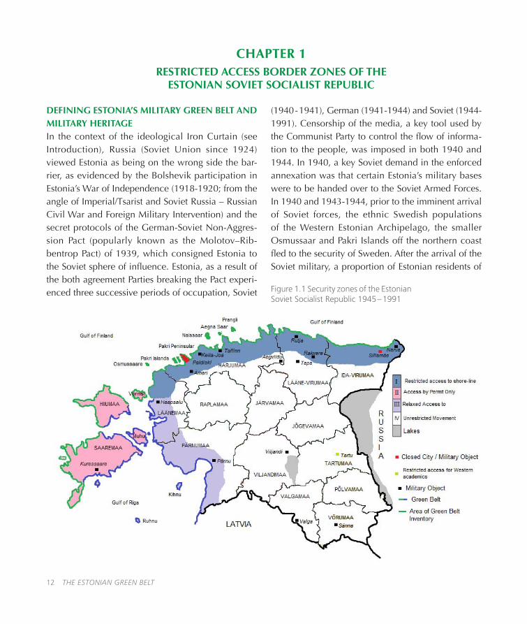
The purpose of the maps preceding Chapters 1, 4 and 5 is to provide a simplistic visual representa-tion, against the background of the Soviet security zones, of the key locations in the Green Belt Project area and the Military Green Belt areas as mentioned in each of the relevant chapters: cities and military objects (Figure 1�1); protected areas (Figure 4�1) and frequencies of human pressure and the texts in the Boxes (Figure 5�1)�
Chapter 1. Jüri Pärn and Argo Peepson set the his-torical background to Estonia’s Green Belt They give a brief overview of the Iron Curtain, the Soviet inva-sions of 1940 and 1944, the creation of the security zones, the difficulties people had with travelling in restricted areas, the withdrawal of Russia’s former Soviet military forces between 1991 and 1994 and the creation of the Estonian Green Belt�
Chapter 2. Jüri Pärn, a founding member of the Hiiu maa Military History Society, brings a wealth of research experience in Estonian military history of the 20th century to exploring the Soviet military infrastructure throughout Estonia� Pärn explains the paradoxical, bizarrely positive, relationship between the presence of the Soviet military infrastructure and the natural environments of the Green Belt areas� Pärn concludes by presenting two case studies of new uses for military heritage objects and explaining the importance of Military Heritage Objects to society�
Chapter 3. Eminent geologist Anto Raukas explores the negative local, national and international out-comes of Soviet (mis)management regulations con-cerning storage and disposal of waste products rang-

THE ESTONIAN GREEN BELT 11
ing from the mundane (sewage) to the exceptional (radioactive waste)�
Chapter 4. Argo Peepson, consultant at the Centre for Ecological Engineering Tartu (CEET) focus on the values of the natural environment and the develop-ment of Estonia’s efforts to protect the diverse natural and semi-natural landscapes, as well as their abun-dant flora and fauna, in the Green Belt areas through the creation of National Parks, Landscape Reserves and Nature Reserves� Peepson explains the interest-ing development of the local level creation of pro-tected areas, particularly in the context of urban municipalities and explores the two key ‘human pres-sure’ threats to the survival of natural environments: the ‘gentrification’ of the countryside and suburban
developments�
Chapter 5. Luule Lõhmus, Private Consultant in Envi-ronmental Management and an expert in investigating cultural and natural heritage explores the importance of objects of natural, military and cultural heritage and expands the discussion of the threats of human pressure within Estonia’s legislative framework and the laws of nature�
Estonia’s Green Belt is truly a pearl in the Baltic Sea region� Hopefully this book will encourage you to visit Estonia and explore the diversity of protected landscapes, their equally diverse flora and fauna, and the abundance of objects of military and cultural heri-tage – natural and man-made�
If you cannot come to explore Estonia at ground level, we suggest an aerial exploration via the Estonian Land Board’s high definition website Maaamet.
The homepage of Maaamet is in Estonian and so is the key dialogue box on the English-language page� To access Maaamet, follow these instructions:
1� Insert this URL into your browser bar http://xgis�maaamet�ee/xGIS/XGis
2. On the homepage Maa-ameti Geoportaal, find the ENG button in the top left corner and click� The new page is Estonian Land Board Geoportal�
3� Click Enter Web Map Server�
4� On the new (English language) page, you will see a map of Estonia on the left and a group of dialogue boxes on the right� Find Otsi aadressi/tunnust� The box for in-putting the location you want to find is temporarily marked nt. Mustamäe tee, 51 Tallinn. As you type in the location, Maamet’s database will offer you a selection of locations�
Please note that in putting English words will not have any effect as the database is in Esto-nian� Look out for these common Estonian words or abbreviations and their English transla-tions: tn (street); tee (road), järve (lake), küla (village), vald (administrative unit)�
Click either the first on the list or the shortest and then use the buttons above the map to navigate and zoom� To zoom in: (i) click + (ii) click the location on the map� To zoom out: (i) click – (ii) click the location on the map�
12 THE ESTONIAN GREEN BELT
CHAPTER 1RESTRICTED ACCESS BORDER ZONES OF THE
ESTONIAN SOVIET SOCIALIST REPUBLIC
DEFINING ESTONIA’S MILITARY GREEN BELT AND MILITARY HERITAGEIn the context of the ideological Iron Curtain (see Introduction), Russia (Soviet Union since 1924) viewed Estonia as being on the wrong side the bar-rier, as evidenced by the Bolshevik participation in Estonia’s War of Independence (1918-1920; from the angle of Imperial/Tsarist and Soviet Russia – Russian Civil War and Foreign Military Intervention) and the secret protocols of the German-Soviet Non-Aggres-sion Pact (popularly known as the Molotov–Rib-bentrop Pact) of 1939, which consigned Estonia to the Soviet sphere of influence. Estonia, as a result of the both agreement Parties breaking the Pact experi-enced three successive periods of occupation, Soviet
(1940 - 1941), German (1941-1944) and Soviet (1944-1991)� Censorship of the media, a key tool used by the Communist Party to control the flow of informa-tion to the people, was imposed in both 1940 and 1944� In 1940, a key Soviet demand in the enforced annexation was that certain Estonia’s military bases were to be handed over to the Soviet Armed Forces� In 1940 and 1943-1944, prior to the imminent arrival of Soviet forces, the ethnic Swedish populations of the Western Estonian Archipelago, the smaller Osmussaar and Pakri Islands off the northern coast fled to the security of Sweden. After the arrival of the Soviet military, a proportion of Estonian residents of
Figure 1.1 Security zones of the Estonian Soviet Socialist Republic 1945 – 1991

THE ESTONIAN GREEN BELT 13
some islands off the northern coast and the Pakri Pen-insula were forced to leave their homes, and because the German armed forces partially maintained the Soviet restrictions of access, most of the former resi-dents could not, until 1991 or even 1994, return to whatever remained of their homes�
On 26th October 1946 the Council of Ministers of the Estonian SSR issued a secret regulation No� 058 “About the restricted border coastal belt in Estonian SSR and the regime in it”, which was changed sev-eral times, and later replaced by regulation No� 07 on February 14th, 1955� This regulation established a restricted border coastal belt, which included all the Estonian sea islands, the town Paldiski, the ter-ritories of 24 village councils in 7 counties (except 15 larger settlements and the recreational area of Lake Harku)� The area this regulation covered was essen-tially Zones I, II and III in Figure 1�1�
Movement within the Border ‘security’ zones depended on the possession of work certificates and passes and a border zone permit� Regulations con-cerning the restricted border coastal belt had either special paragraph or up to four page appendix listing several dozen of special exceptions that were allowed into the border zone without a special permit, just by showing their work certificates -- assemblymen, ministers, militiamen, leaders of the Communist Party, the President and the Vice-President of the Academy of Sciences etc�; and (in the regulations issued since 1959) military personnel by showing their travel cer-tificates and identity cards. For the rest, permits were issued on the basis of whether or not the ’movement’ and the ’intended activity’ were useful� For example, a key economic activity on the northern coast was sea-fishing. The Soviets organized fishing collectives (kolkhoz), many workers for which needed a ’bor-der zone permit’� Local authorities were required not only to surround all ports in border zones with security fences but also to conduct continuous sur-
veillance around these fences, to count the number of fishing boats and to ensure the boats were locked up overnight� The Soviet border guards claimed the restrictions were in force to make it difficult for an enemy to conduct sea-borne invasion (intrusions did occur for several years after WWII), although many local Estonians believed the restrictions were to stop anyone from fleeing to Finland.
Visiting the islands of the Western Archipelago was not easy for most Estonian non-island residents unless they had a close family relative living on the island of their destination� Intended visitors had, initially, to apply for a ‘border zone permit’� Visitors initially had to apply for a land (visitor’s permit) at their local Department of Internal Affairs and also register their destination, if staying for longer than a certain period, at their local municipal council� Secondly, visitors had to register at the Border Guard Headquarters, which would check all the details on their ‘anketa’� In due course, and only after lengthy deliberation would a ‘permit’ be issued� Only after showing the signed authorization to the harbour master or commander of a coastal patrol vessel, was the visitor permitted to go to their island destination(v)�
The result of the ‘security restrictions’, which the Soviet military enforced in the border zones, was that the traditional activities of local inhabitants were either curtailed or in military areas prohibited alto-gether� Nearly two generations of Estonians grew up and lived with the knowledge that going to the sea-side was forbidden and punishable(vi) and coastal settlements with their traditional rural landscapes started to disappear�
The presence of Soviet military installations was a key determinant of the existence of a security zone� There were four conceptual categories of restrictions, which were applied to urban and rural municipalities and geographical areas (see Figure 1�1 and Table 1�2)� In principle, therefore, wherever there was a military

14 THE ESTONIAN GREEN BELT
installation there was a security zone, which could be applied to most of Estonia’s municipalities, urban and rural (i�e� almost the whole of Estonia)�
Restrictions of access to the university city of Tartu applied only to Western academics because of the presence of the Soviet Air Force’s Strategic Bomber airfield located no more than three kilometres from the city centre� Foreign academicians visiting the uni-versity had to be accompanied by an Intourist guide and were closely watched by the KGB – overnight accommodation was, if necessary, provided in Vil-jandi�
The government of post-Soviet Estonia agreed to include the nation’s coastline in the European Green Belt project, in 2006, and in the region-specific Baltic Green Belt sub-project in 2009 (see Järv 2010)� Esto-nia’s Green Belt (see Figure 1�1) is essentially a 25 km
wide coastal strip around the islands and mainland, in which there is a broad range of landscapes, naturally bio-diverse, planned, economic and all both histori-cally valuable and worthy of legislative protection�
The north coast (Zone I), the open sea coasts of the Western Estonian Archipelago (Zone II) and the West Coast (Zone III) comprise not only the Estonian Green Belt, but also the Estonian Military Green Belt (see Chapter 2)� The remainder of the territorial area of Estonia we shall call the ‘hinterland’ (Zone IV) where movement was unrestricted, except in the environs of military bases and other (civilian) restricted areas�
During the last Soviet period, 1944-1991, approxi-mately 4,000 Soviet military units were stationed at one time or another in Estonia� The data presented
Category Restrictions Security
Zones Geographic Area Specific Locations
1a Border zone permits required; no access to the shore-line for all non-productive activities
I North coast Depth of 25 km from Narva to Haapsalu
1b Access to the sea for recreational purposes was more relaxed and unrestricted after the 1950s.
III West coast Depth of 25km from Haapsalu in the north-west to the Latvian-Estonian border in the south-west
2 Permits required for most non- residents of respective islands
II Open-sea coasts of Western Estonian Archipelago
Depth of 25km on Saaremaa, Hiiumaa, Vormsi
3 ‘Closed cities’ - off limits to everyone except their residents and authorized workers;
Prohibited to casual unaccompanied visits by Western academics
I
IV
North-east near Narva
North-west near Tallinn
Central-east
Sillamäe in Zone I
Paldiski in Zone I
Tartu in Zone IV
Table 1.2 Distribution of Restriction Categories and Security Zones in Estonian Soviet Socialist Republic
THE ESTONIAN GREEN BELT 15
in Table 1.2 reflects only the main units stationed throughout Estonia, showing their distribution amongst the security zones (I-IV)�
Despite the parameters of the Estonian Military Green Belt being based on Soviet security zones, the vis-ible and invisible military features are not restricted to post-WWII Soviet military activity during the period 1944-1991� Estonia due to its location, as a gate-way to Russia, has experienced frequent invasions and subsequent occupations since the 13th Century: Danish crusaders (13th Century); German Teutonic Knights of the Livonian Order (13th Century); Musco-vites (16th Century; Swedes (16th and 17th Century); Poles (17th Century); Imperial Russians (18th Cen-tury); Bolshevik Russians (20th Century); Nazi Ger-
mans (20th Century); and lastly Russians and Soviet Union nationalities (20th Century)� Each successive invasion and occupation partially or totally destroyed the infrastructure of the previous invaders and left behind a new layer of infrastructure and artefacts� Estonia has such a sufficiently small land area, the longest diagonal measurement from the north-west (Paldiski) to the south-east (Napi) is approximately 300 km, that few areas have been untouched by mili-tary activity in the last eight centuries�
Nevertheless, the quantity of military installations, factories and assorted administrative and support facilities constructed by the Soviet armed forces far exceeds any of the previous occupying forces�
CHAPTER 2SOVIET MILITARY INFRASTRUCTURE AND ITS FORMATION IN ESTONIA
MILITARY HERITAGE
Military Heritage can be understood as referring to all objects resulting from, or related to, military activ-ity ranging in scale from the macro of national and invading armies and occupying forces to the micro of individual people�
Military Heritage objects (MHO) are tangible artefacts related to military activity of any culture or era, vary-ing in durability and size from building type construc-tions (e�g� fortresses, towns, artillery emplacements, sentry towers and observation posts) to war materiél (unexploded bombs, mines and shells, arrow heads, shell casings) and bio-degradable artefacts (uniforms, wooden constructions and tools, documents)� MHOs can be found on invasion routes in temporary infra-structures in the form of transit camps, battle-fields and mass graves and of occupying forces in per-manent structures such as administrative buildings,
war materiél production centres, and ethnic specific cemeteries� Invariably MHO locations have layers of artefacts from previous invasions and occupations but even when nothing is visible the location is worthy of identification as a valuable source of information.
Some Soviet MHOs have tenuous, but historically important links to military activity� These are primar-ily civilian structures that have been used by military organizations – the Grey House in Tartu was the KGB regional headquarters in the 1940s and 1950s – or are anecdotally linked to military activity� For exam-ple, there is a house on Tähe Street in Tartu, which managed to escape the looting in 1944, thanks to a communist neighbour who put a sign on the door with text in Estonian and Russian: “Taken over by the commandant’s headquarters! Trespassers will be shot!” Many Soviet MHOs are related to civilian orga-

16 THE ESTONIAN GREEN BELT
nizations, which were tasked with the foreign and domestic protection of the country and were involved in national defence�
The survival of any MHO depends on a number of characteristics: re-usability; recyclability; propaganda value; durability. The first three characteristics may be viewed as essential issues, which both victor and the loser should consider� Can the MHO be instantly re-used by the victor in its current state? Can the mate-rial of the MHO be recycled? Does the MHO have (propaganda) value of use to the victors? The final characteristic, durability, refers to the MHO’s ability to endure the natural effects of time and the envi-ronment� Current environmental ideology marks all MHOs with two further characteristics, which may be referred to using a cancerous analogy as having either a benign (neutral) or malign (negative) effect on the environment�
In the context of the landscapes of Estonia’s Military Green Belt, these characteristics are of key impor-tance� Military activity has over the centuries become increasingly dependent on technology that relies on materiél that is inherently malignant to the natural environment (e�g� explosives, fossil fuels, rubber tyres, compound fuels, nuclear fuels), which require an increasingly broad range of sizable support services and facilities that are fairly benign on the environ-ment (administrative and technical support buildings, artillery emplacements, communication and transport networks)� Furthermore, Estonia’s Military Green Belt on the northern coast (Zone I) and the archipelago islands (Zone II) experienced a higher level of mili-tary activity compared to the rest of the country� This was because the northern coastal areas (a) bordered the prime Soviet invasion route in 1944, (b) formed the approach funnel to Tallinn, which necessitated the formation of a defensive barrier against invasion and (c) were endowed with natural deposits of oil shale� The islands of the archipelago (Zone II) on the other
hand were of paramount strategic importance as they controlled access to both the Gulf of Riga to the south and the entrance to the Gulf of Finland to the north�
A historical note at this point relevant to the Soviet’s aim of securing access to the Gulf of Finland con-cerns the coastal districts of Hanko and Porkkala, both of which are in the coastal south-west of Fin-land� In early 1941, as a term in the treaty ending the Finno-Soviet Winter War, Finland leased Hanko to act as naval base to the Soviet Union for 30 years� The Soviet Union was forced to withdraw its Hanko forces in December 1941 during the Finno-Soviet Continua-tion War (1941-1944)� In 1944, as a term in the treaty ending the Continuation War, Porkkala in Finland replaced Hanko and the lease was extended to 50 years� Artillery at Porkkala included half a dozen 130 mm (range 32 km) and a twin-turret 305 mm (range 43 km) on the Finnish island of Mäkiluoto directly north from Tallinn across the Gulf of Finland� With the aid of artillery on the coastal environs of Tallinn, the Soviet artillery in Porkkala controlled the maritime access to Leningrad� The Soviet Union relinquished the Porkkala lease in 1956�
The majority of MHOs of Soviet origin have the essential characteristics of being re-usable and benign for any of four reasons: (i) they were originally built by construction units of the armed forces for civilian usage – e�g� the indoor swimming pool in Tallinn and the Tallinn Excavator Factory production buildings; (ii) they have since been used in a civic capacity - the airfield at Ülenurme near Tartu, Soviet Air Force accommodation blocks in Tartu and the Navy’s port facilities at Paldiski; (iii) they are no longer in use but are being maintained - the Red Army cemetery at Sin-imäe, and (iv) are slowly falling into ruins - artillery emplacements on the northern coast, bomb shelters constructed by farmers for their own use. The first category is the least common compared to the other three�

THE ESTONIAN GREEN BELT 17
In a country as small as Estonia, the reader is forgiven for thinking that an audit of all the MHOs would be a fairly easy exercise to conduct� However the com-bination of the Soviet paranoia about maintaining a veil of secrecy concerning all military matters, the extremely complex and chaotic accounting systems of the Soviet armed forces and lastly the almost com-plete lack of organized archiving of documentation concerning military units in Estonia ensures a detailed audit is difficult to conduct. Consequently Estonia often has substantially less information about MHOs from the second half of the 20th century than about significantly older MHOs. So whenever possible, we should treat these “ruins of war” on the same basis as millennia-old archaeological sites� Even the most seemingly hopeless ruins can give us valuable infor-mation�
MANPOWER LEVELS OF THE SOVIET ARMED FORCES IN ESTONIA 1944-1994
Manpower levels of the Soviet armed forces in Esto-nia at any time between the 1944 invasions and their withdrawal in 1994 are difficult to ascertain. Despite every unit in the Soviet armed forces having an administrative section that accounted for its mili-tary strength, each branch of the armed forces (e�g� Strategic Rocket Forces, Ground Forces, Air Forces etc�) had their individual accounting systems� Fur-thermore, each branch could have separate division subordinate to different administrative bodies� For example, although Tallinn Naval Base had its own accounting section, there were naval units subordi-nate to the Baltic Fleet and other units subordinate to the Navy Main Staff in Moscow, each of which had another accounting system. In the fifty years between the end of WWII and the withdrawal of the Soviet military in 1995, approximately 3,000 military units were stationed at one time or another in Estonia with a bewilderingly complex arrangement of subordi-nate links� Although, Estonian archives do probably
hold certain documents concerning the majority of these units, no organization or individual has yet had the time or the funding to carry out an exhaustive research to calculate the exact numerical levels of the Soviet armed forces in that fifty year period. Thus the oft quoted statistic, for 1984, of 122,480 Soviet mili-tary personnel stationed in Estonia should be treated as misinformation (see for example Salo et al� 2005; Regional Action Plan)�
Estimates, based on the war-time and peace-time strengths of the units known to be present in Estonia at one time or another, are also highly variable (see Table 2�1)� The main reason for the high level of vari-ability is that the nomenclature of Soviet military units denoted a smaller manpower level than their West-ern counterparts and did not equate to any unifor-mity. The war-time strength of a Rifle Corps could be between 20,000 and 40,000 depending on the num-ber of Rifle Divisions (2-4) subordinated to the Corps. The peace-time strengths of any military unit could be as low as 25 per cent of their wartime strength (and even less)�
Despite being unable to accurately assess their numerical strength in Estonia, the Soviet armed forces were similar to other military forces of the 20th cen-tury in their requirements for operational and support facilities and accommodation� Consequently, the length and breadth of Estonia’s Green Belt witnessed a mushrooming of military installations to meet a complex array of requirements�
The Soviet Armed Forces consisted, initially in 1925, of five ranked (by order of importance) elements – Ground Forces, Air Forces, Naval Forces, the Troops of the United State Political Directorate (OGPU) and the Convoy Guards of the Soviet Union (Con-voy Troops since 1930, under NKVD since 1934)� By 1960, advances in military technology had not only changed the methods of conducting warfare but also caused the addition of four new elements, which

18 THE ESTONIAN GREEN BELT
altered the order of importance: Strategic Rocket Forces (instigated 1960); Ground Forces; Air Defence Forces (instigated 1948); Air Forces; Navy (those five were Armed Services); Airborne Troops (separate arm of service since 1946, within Land Forces, but under the direct command of Minister of Defence in peacetime); Civil Defence Troops (handed over from the Ministry of Internal Affairs in 1960); KGB
Troops, including Border troops (according to com-mon knowledge� just the Border troops of the KGB were part of the Armed Forces); Internal Troops (Min-istry of Internal Affairs)� In addition, there were two large groups of troops – the special troops with about 20 branches (subordinated to respective Directorates
Peak Period Strength Reason for Reduction 1944 Simultaneously up to
about 500,000 (may be as many as 1,000,000 men during the year)
1945-46 up to 150,000 Demobilization, troop levels diminishing to peace-time strengths
Mid 1950s about 80,000 Death (1953) and condemning of Stalin, dismissal of the national divisions in Soviet Union and further unilateral reducing of Soviet Armed Forces (caused by development of the missile technology)
Mid 1960s 50,000 Completing the most important missile sites, reducing Border Troops
Mid 1970s 45,000 Strategic missile reducing (1978), completing most of the Paldiski Training Centre
Mid 1980s 40,000 Perestroika and Arms Control Treaties 1991 35,000 Restitution of Estonian Independence,
dispersal of the Soviet Union, Troops withdraw
August 1994 over 200 announced Withdrawing the Paldiski reactors’ dismantling crew
September 1995 up to 200? (unannounced)
Left in Estonia: subsidiary units of Military Intelligence and other services – military pensioners’ record-keeping, the crew of military attaché, security, etc.
Table 2.1 Estimated Red Army strengths in Estonia 1944-1994
THE ESTONIAN GREEN BELT 19
and Services of the Ministry of Defence and General Staff), and the Rear of the Armed Forces� All these key elements and most of their sub-branches were represented at one time or another in Estonia (see Table 2�2) and are the sources of Soviet MHOs� Also, many other Soviet Union Ministries had their own military units which made part of the Soviet Armed Forces, too, and some of them were located in Estonia�
From 1944 to 1956, Estonia was included in the Len-ingrad Military District (1944-45 named as Lenin-grad Front), after which it was included in the Baltic Military District (North-Western Group of Forces in 1991–94) with its headquarters in Riga, Latvia�
The most frequently used statistics referring to the quantity of ex-Soviet military objects in Estonia are: 1,565 (Estonian Ministry of the Environment) and 1,581 (Estonian Ministry of Defence)� But like the sta-tistic given for the soviet military personnel stationed in Estonia in the 1980s, these two statistics should be treated with a certain amount of caution� There is a sufficiently large difference between the statis-tics of the Russian authorities, who mentioned 4,900 military objects remaining in Estonia (see Glossary: Handover Documents) and those of the two Estonian government Ministries to warrant an explanation�
A Commission for the Ministry of the Environment evaluated the cost of the clean-up operation of Soviet military pollution� The evaluation process indicated that at the end of the Soviet occupation, there were 1,565 military objects in Estonia in approximately 800 locations, totalling 87,000 ha or approximately 1.9% of the country(ix). Unfortunately, all figures in this sentence are debatable�
Up until the accounting of soviet military objects was taken off the work plan in about 1995, the con-struction department of the Ministry of Defence had assessed 1,581 military objects, which were essen-tially encompassed by different areas of land that had been mapped in 1991 by the National Project Institute’s (RPI) Estonian Agricultural Project� The par-cels of land varied enormously from 0�01 ha to the 33,000 ha site near Aegviidu� The latter was primarily an area of the Pavlov Military Forest Enterprise with several different functional objects and hundreds of buildings and structures on it (e�g� an Air Defence Forces’ surface-to-air missile base and two practice centres under distinct subordination – for motor rifle and engineer forces). There could also be sev-eral accounted objects in a single large land parcel� Paldiski, for example, accounted for as a single mili-tary object of the Navy, covered a large area of the Pakri peninsula and included several smaller mili-tary objects belonging to the Border Troops and Air Defence Forces�
After compiling the initial list of the land parcels, the military residential buildings which had ordinary town addresses (street names and house numbers) began to be added as separate military objects� For example, over 60 objects were added to the data-
BRANCH PEAK STRENGTH Strategic Rocket Forces 4,000 Land Forces 20,000 Air Defence Forces 9,000 Air Forces 8,000 Navy 16,000 Civil Defence Troops 1,000 Other Ministry of Defence troops 15,000 Border Troops (KGB) 6,000 Internal Troops (Ministry of Internal Affairs - MVD)
3,000
Troops of other Ministries, e.g. DOSAAF 2,000
Table 2.2 Estimated Peak Strengths of Core Branches of Soviet Armed Forces 1956-1994

20 THE ESTONIAN GREEN BELT
base by processing Tartu’s military residential district called “Chinatown” (Shanghai in Russian)� Addi-tionally, part of the residential buildings and other, mainly personal service facilities located inside larger military complexes (such as the ones in Ämari and Rakvere, originally in the database as single territo-ries, accounted as one whole with their barrack and headquarter area) were entered into the database as separate objects� Conversely, many smaller military units or their separate subunits had up to eight adjoin-ing residential buildings which were not documented there as separate objects� This lack of consistency simply adds to the confusion in the accounting pro-cess, which is further aggravated by the arguments over whether or not objects of DOSAAF (The Volun-tary Society of Assistance to the Army, the Air Force and the Navy), Estonia’s Civil Defence and Estonia’s KGB should be included as military objects�
Despite DOSAAF being a paramilitary organization and ranked tenth in our hierarchy of Soviet Armed Forces (because it officially did not belong to the Armed Forces), and the KGB Troops being ranked eighth, the subjects of both organizations were not under the jurisdiction of the Soviet military pow-ers during peacetime� The immense size of Estonia’s branches of both DOSAAF and KGB as proportions of the Estonian population, then and now, is one argu-ment for the organizations’ inclusions� There was only one active DOSAAF officer, a Major General, who was the Chairman of the DOSAAF Estonian Repub-lican Central Committee, but there were 472,655 members (in 1979) of whom 122,000 were active in the military sports and activity sections (e�g� sports and activities that can be used operationally: para-chuting, driving, radio mechanics etc�)� The KGB on the other hand had entirely military structure by itself and in Estonia about 2,000 staffers (about 1,000 of them were ranked officers) controlling approximately 30,000 agents and several thousand expropriated administrative support staff� These statistics equate
to approximately 7�5% of the population (DOSAAF active members) and 2�5% (KGB staff and cooperat-ing persons)� The DOSAAF members were not orga-nized into military units, but rather as support organi-zations and a significant majority of them had simply paid their dues� DOSAAF did however have its own airfields (4-5 in Estonia), shooting ranges, radar posi-tions and many other war-like objects�
A secondary argument is that, while military objects related to front line units are more interesting to mili-tary enthusiasts, objects of the KGB have their own inimitable fascination by virtue of being related to a globally renowned espionage organization� KGB objects included, other than the administrative cen-tres, government communication centres and points, eves-dropping centres, ‘safe’ houses (conspiratorial apartments) and resting places (rest homes, saunas, etc�), as well as the KGB’s undercover facilities and organizations (such as the Writing Machines and Computer Service and Repair Factory ‘Impulss’ or the Association of Developing Contacts with Foreign Estonians)� The Estonian KGB could have up to 1,000 of these kinds of objects�
A less well-known organization was Estonia’s Civil Defence Staff, which had administrative offices in 25 cities and towns, local Civil Defence headquarters or single Civil Defence workers at up to 2,400 enter-prises and could call upon several hundred thousand “volunteers”� This organization was responsible for the shelters constructed or modified and equipped for the purpose of civil protection� In 1990, there were over 290 bomb shelters (for approximately 60,000 people) in Tallinn alone� In February 1986 in Esto-nia as a whole, there were 543 bomb shelters (for over 100,000 people), 7,343 radiation shelters (for 780,000 people) and approximately 21,000 cellars that could be modified into different kind of shelters (for 1,854,170 people –– the population of the Esto-nian SSR was, at the time, nearly 1,6 million)�

THE ESTONIAN GREEN BELT 21
METHODS AND MATERIALS USED IN THE CON-STRUCTION OF MILITARY INFRASTRUCTURE OBJECTS
Four prime examples of medieval military infrastruc-tures exist within the northern coastline and archipel-ago of the Estonian Military Green Belt (Zones I and II)� They are, moving from east to west – Narva Castle; Rakvere Castle; Tallinn Castle’s Outer Walls and Gates and the Episcopal Castle on the Island of Saaremaa� These fortifications were constructed entirely by man-ual labour using the most rudimentary of technology and design skills, yet they have survived for the best part of seven hundred years� Construction time, from start to completion, depended on the availability of labour and does not, like quality of material, sig-nificantly affect the durability of the structure. King Richard I of England used 6,000 labourers to build Chateau Gaillard in Normandy� The foundations were laid in 1197 and the fortress was completed in 1198� Only the depredations of siege warfare turned Cha-teau Gaillard into ruins, but the donjon survives to this day�
In 1940-1941, during about one year between the Soviet annexation of Estonia and the German inva-sion, the Soviets conducted under a veil of secrecy a massive construction programme of artillery defen-sive positions along the Soviet coasts of the Baltic Sea using 210,000 m3 of reinforced concrete� For com-parison, between 1927 and 1932, the Soviet Union had constructed Europe’s largest dam, the Dnieper Hydroelectric Station, using 1�2 million m3 of con-crete at an average annual rate of 236,000 m3�
The intriguing question is whether or not any of the military objects constructed between 1944 and 1991 will endure for seven hundred years� The post-1950s type of construction was called “economization”, of which a key factor was the use of readily available materials that were as cheap as possible� For exam-ple, the military often used scrap bricks from the
scrap storage area of the Männiku Silicate Brick Fac-tory in Tallinn for their construction projects� There-fore, on the basis of the economic concepts, which under-pinned Soviet industry, mass production, low cost labour (the military had their own construction battalions), production-output driven programmes and weak quality control of materials, most of the Soviet military objects will not last that long� Never-theless, military objects completed before 1960 were better constructed than in the ensuing three decades, because more people had pre-war building skills�
Seven hundred years ago military leaders wanted their fortifications to last forever (just as their coun-tries and power of their families)� But there are at least two reasons why the Soviet military would not desire to build their military installations to last ‘for ever’� First, weapon systems develop quite rapidly, and military dislocation is dependent of this evolu-tion� Decades later there a military unit may not be needed in the same place but somewhere else� Thus, it was pointless to waste extra financing to build a durable military infrastructure� For example, an ordi-nary timber frame barrack was meant to last for just 25 years� By which time the unit might have been relocated to some other place� Also, there was the hope of reaching universal communism during the post-WWII decades, which would negate the need to have most of the military installations�
However, without human interruption and deliber-ate demolitions, many of those buildings could last for several hundred years� One reason that old mili-tary architectural monuments abound is that our pre-decessors did not have sufficient free time and the necessary techniques for demolishing them� Now, although there has been sufficient time and proficient demolition methods for the last two decades, there is the Estonian paradox of having sufficient aware-ness to conserve 100-700 year old buildings, but not enough to preserve 30-50 year old buildings�

22 THE ESTONIAN GREEN BELT
COASTAL ARTILLERY BATTERIES
In Zone I of the coastal greenbelt from the island of Osmussaar to Narva (see Figure 1�1), there are the more or less preserved remains of at least 70 perma-nent coastal artillery batteries and a similar number split between the western coast, Zone III, and the archipelago, Zone II; altogether about 150 battery sites (not all of them reached completion)� These bat-teries were constructed or reconstructed from 1912 to 1960, by either Russian, Estonian, Soviet (50-60) or German armed forces (10-15)�
During the 1940-41 construction programme, explained in the previous section, the Soviets reno-vated 9 Imperial Russian and pre-WWII Estonian batteries to take large and medium calibre (100-356 mm) coastal defence guns and constructed 24 new ones, and also 10 small calibre (45-76-mm) batter-ies� In 1941 the Russians blew up and burned the equipment of most of these batteries, but for all that many buildings and installations of them are well pre-served, particularly the machine gun pillboxes (half-caponiers)�
In May 1945, the Soviet’s large and medium cali-bre coastal batteries were located in: Tallinn Coastal Defence Sector (13 batteries), Porkkala-Udd Coastal Defence Sector (8, in Finland) of Tallinn Naval Defence Region; Islands’ Naval Defence Region, Saa-remaa (9) and its Coastal Defence Sector, Hiiumaa (5)� There were also at least two railway batteries on the Pakri Peninsula�
HYDROGRAPHY
The entire hydrography service in Estonian area of the Baltic Sea was subordinated to the Soviet Navy between 1940 and 1993 (except during the German occupation in 1941-44)� The Soviet Navy took over the lighthouses at Kõpu, Osmussaar, Pakri, Ristna, Sõrve and Tahkuna on May 15, 1940 and the rest
of the hydrography service in Estonia on January 1, 1941� Objects of the hydrography service include shore based (lighthouses and light stations, day bea-cons) and sea based (buoys and spar buoys, light ves-sels, also some lighthouses) navigational aids, nau-tical charts and books, ship navigation systems and equipment, etc� Operational Estonian lighthouses (those that continue to work) can date from the end of the 19th century (some of them are older, e�g� Kõpu lighthouse on Hiiumaa since 1649, day beacon since 1531), but most are from either the early 20th Cen-tury or the Soviet period�
In 1988, there were 26 ‘tall’ lighthouses, visible from distances greater than 15 nautical miles and 30 ‘shorter’ lighthouses, visible from 10-14 nautical miles on the Estonian coast of the Baltic Sea� In addi-tion to the permanent sea marks, the hydrographi-cal service also had several hundred buoys and spar buoys in the Baltic Sea, which have been removed each year before the sea froze over� There were 24 Light Stations (which comprise the Lighthouse tower and all outbuildings, such as the keeper’s living quar-ters, fuel house, boathouse, and fog-signaling build-ing etc�) on Estonian sea coast, with usually 3-8 civil-ian persons paid by the Navy�
Two types of objects of the hydrography service are especially worth mentioning, permanent sea markers and the MARS-75 radio navigation system� The for-mer does not have a direct link to the military of any particular century but is of interest as being a histori-cally traditional method of marking dangerous low lying rocks or fairway directions with a permanent, highly visible structure and possibly a light� By con-trast, the MARS-75 radio navigation system was one of the most accurate systems prior to satellite technol-ogy and GPS, the system was accurate to within 250 metres� Little is known to the general public about the system except for the existence of three MARS-75 sys-tems in the Artic, the Baltic and the Black Sea� Each

THE ESTONIAN GREEN BELT 23
system was dependent on the triangulation of three or four fixed locations. The 2nd sub-station of hydrogra-phy service’s 496th Radio Navigational System was situated on Mähe Road in Tallinn and formed one node of the triangle necessary for the Baltic Region, the others being at Wustrow in the previous German DR and the primary (leading) station at Sovetsk in the Kaliningrad oblast� Thus it is an object that stretched through most of the nowadays Baltic Green Belt�
PRISONER-OF-WAR CAMPS
Prisoner-of-war (POW) camps comprise a key ele-ment of both military and civil infrastructure during a war of which 10 to 11 were Soviet camps recorded in 1944-50, spread over at least 45 sites� Although there is not much visible of any of these camps, the evidence of the work done by German prisoners-of-war does still exist� For example, from 1946-1949, German prisoners-of-war laid a 50 km concrete road, 7 m wide, from Tallinn to Vahastu, close to the vil-lage of Kolga� This was, at the time, Estonia’s longest concrete road� During roadwork in 2005, concrete blocks measuring 27 cm thick and 3�5 m wide were removed and two of those blocks were placed in the Estonian Road Museum in an outdoor exhibit in Var-buse, Põlvamaa�
About the same number of POW camps in Esto-nia had the German military in 1941-44, and tens of camps for Jews and other detention facilities, which also had been employed for the German war machine�
RAILROADS ON SAAREMAA ISLAND
In 1951, Moscow decided a railway was needed on Saaremaa to link the island’s military airfields and the coastal batteries� The railway was also meant to haul heavy (348 tonne) 16-axle railway artillery cannon� By the autumn of 1951, the troops of a railway con-
struction division had arrived on Saaremaa and were accommodated in Kuressaare and about 20 km away in Viki village� The route of the line went from the Viki junction in five different directions towards the island’s three largest ports, Roomassaare, Mõntu and Jaagarahu and also to the Kogula airfield. The initial work of creating embankments and laying the track enabled temporary rail traffic on the initial sections in the summer of 1952� But then in 1953, all work slowed down� This was either due to Stalin’s death or a change in the Soviet defence strategy due to the development of rocket technology�
By late 1955, 500 km of embankments and 250 km of track had been laid� When Estonian Railway took control in 1956, it was soon discovered that for finan-cial reasons it would be more prudent to cease the project and dismantle the track, which was hauled out through Roomassaare harbour� The dismantling took four years� The embankments were handed over to the Saaremaa Road Construction Department which later created almost 60 km of roads on the railway route� The buildings associated with the con-struction division and the railway supervision were taken over by the Ministry of Education, Saaremaa’s Executive Committee, the local fish factory and the road department� Several houses in Kuressaare and Viki were taken over by other units of the Soviet Armed Forces�
HIGHWAYS ON HIIUMAA ISLAND
Whereas Saaremaa had a railway construction proj-ect, Hiiumaa, the island to the north, had a compara-tively large highway construction project (code name “Road U-6”)� The Single Road Construction Corps that was subordinated to the Ministry of Internal Affairs of the USSR (MVD) provided two battalions for the labour force� The aim was to broaden and straighten out not only the entire 150 km main ring road but also some of the access roads to the military units

24 THE ESTONIAN GREEN BELT
(mostly the coastal batteries) located all over the Hii-umaa� This work began in 1952 and ended in 1953, just as suddenly as the railway project on Saaremaa, for the same reasons� At the time parts of the project had not gone beyond the design stage and several sections (over 40 km in total) had not been started� Soon after Stalin’s death, the Internal Minister Lavrenti Beria proposed to take away several construction tasks from the MVD and dissolve the corresponding military units, including the Single Road Construc-tion Corps� However, by that time about 120 km of roads has been built or reconstructed, mostly without the aid of any of the tracked vehicles associated with road building� Anecdotally, the soldiers’ only tools were spade and axe, and every squad of soldiers was supplied with a wheel, with which to make a wheel-barrow using material they ‘found’ somewhere, or stole from local people�
GEODETIC LANDMARKS
Until 1960 the Department of Geodesy and Cartog-raphy was subordinated to Ministry of Internal Affairs of the Soviet Union� Until then the construction and maintenance of the geodetic network of permanently marked points and triangulation towers had been the task of special military units� On Hiiumaa, soldiers had constructed the first triangulation towers in 1940, but they built and reconstructed those even in the late 60s� In the Soviet era these points were called national geodetic network points, which were marked on maps as triangles (and in nature as triangularly dug ditches), and topographic network points, which were marked as squares�
NUCLEAR WEAPONS IN ESTONIA
Despite claims concerning a 1989 Newsweek arti-cle referring to the presence of up to 270 tactical nuclear warheads in Estonia, the Soviet Union never
disclosed the presence of nuclear weapons in Esto-nia, nor have the Russian authorities made an admis-sion to this effect� The Soviet hierarchy of control of nuclear weapons of the Soviet Armed Services was headed by the 12th Chief Directorate of the Ministry of Defence�
Nuclear weapons consist of two types by their target: Strategic has the aim of causing significant, wide-spread damage to the enemy’s ‘rear’ (government, industrial centres and population); Tactical has the aim of causing limited damage to the enemy’s mili-tary formations on a battlefield.
All five of the highest ranked Soviet Armed Services were capable of delivering either or both Strate-gic and Tactical nuclear weapons, the SRF (Strate-gic), Land Forces (Tactical), the Air Force (both), the Navy (both) and the Air Defence Force (Tactical)� The specially constructed, temperature and humid-ity controlled storage facilities, located separately from conventional weapon stores, were under the local control of special military units called Repair Technical Bases� The units tasked with delivering the weapons to the target did not have control over the weapons, other than delivery�
The argument of nuclear weapons being present in Estonia is based on two key factors: Estonia’s strategic position controlling the maritime and air approaches to Leningrad and the presence at one of the Soviet Union’s largest Strategic Bomber airfield outside Rus-sia, at Tartu, of aircraft capable of delivering nuclear weapons� The strongest evidence for the Soviets hav-ing nuclear weapons in Estonia places them in stor-age bunkers near Tartu Raadi airfield, on the Ämari airfield, to the north of Valga, the SA-5 sites at Keila-Joa and Tõõrakõrve (near Tapa), the 9-12 SA-2 sites (Rõngu, Sangaste, Paanikse of the Valga SAM Regi-ment, until 1985; others until 1990: Varinurme, Päide, Kupu of the Rakvere SAM Brigade; Rohuneeme, Lee-tse, Karatuma of the Keila-Joa SAM Brigade; and Piiri,

THE ESTONIAN GREEN BELT 25
Kallemäe, Maantee of the Kingissepa/Kuressaare SAM Brigade on the Islands of Muhu and Saaremaa), and the 9 sites of the SRF near Valga, Võru, Rakvere and Haapsalu�
MILITARY AIRFIELDS IN ESTONIA
Military airfields could be classified as being pri-mary, secondary (reserve) or road extensions (high-way strips) with concrete, asphalt and grass runways� During the period 1945-1994, there were at least 30 primary and reserve airfields of different sizes and qualities and four highway strips. Airfields are the most visible of military objects and when disused are publicly accessible�
The design of each type of airfield depended on the intended usage and in Soviet design consisted of two highly visible (aerial and satellite imagery) features�
Runways: Purpose built airfields (excluding road extension airfields) had usually two parallel runways; the first was the main take-off and landing runway, and the second was a reserve runway at least 2000-2500 m right next to the concrete one, built of com-pressed gravel and covered with grass; and also the taxi way could be used in emergencies for landing, but the length was insufficient for taking-off the bigger aircraft� The width of the runways generally exceeded the wing-span of the aircraft using the airfield; thus the runways of Strategic Bomber airfields were signifi-cantly wider than those used by Interceptor aircraft�
Revetments and Hardened Aircraft Shelters: In order to protect parked aircraft from being damaged or destroyed, by accidental fires and explosions of other parked aircraft or in an air-attack, aircraft were parked in three or two-sided enclosures and hardened shel-ters. On Tartu airfield, these enclosures consisted of grassed-over earthen banks, with bases of 10-15 m and heights of 4-5 m� There was, on the basis of the extremely high level of economic investment in air-
craft, a revetment for each aircraft� Before the 1960-70s there were revetments also on the interceptors’ airfields, but later the soil-covered concrete arch shel-ters were built for the interceptors�
There were six primary airfields; their main runways were at least 2500 m� Bomber Regiment (consecu-tively Tu-4, Tu-16, Tu-22M3) and a Military Transport Aviation Regiment (Tu-4, An-12, Il-76MD) were sta-tioned at Tartu; Interceptors were initially stationed at Ämari, until 1960, in 1960-83 there were fighter-bombers, but from 1983 a Bomber Regiment (Su-24) was stationed there; Interceptor Regiments were sta-tioned at Pärnu, Haapsalu (reconstructed in 1966-1970, formerly a reserve airfield), Tapa (and 1989-1992 a Helicopter squadron), Rutja (used as a reserve airfield); and Tallinn Lasnamäe until 1970 (replaced by Haapsalu airfield). These were all-weather air-fields and had concrete runways. Only two of these are still in use as airfields: Ämari is the main Estonian Air Force base; Pärnu is a civil airport� The only one that has been totally erased from view is Tallinn Las-namäe, which was demolished starting from late 80s to make way for a residential development (but there are several support buildings of it still left between multi-storey residential houses)�
The twenty-four secondary and reserve airfields, which largely had grass runways, have either been taken into agricultural use or have become private airfields.
There are at least four road extension (emergency) air-fields in Estonia, consisting of a paved straight section mostly 2�5 km long and 20 m wide (one was 1�5 km long and 10 m wide) and there were aircraft parking spaces close to each end on either side of the high-way (but without revetments)� The two most visible are at Vatla, Lääne county (starting 1 km NE of the vil-lage) and Jägala, Harju county (2 km SE on Route 13)�
DOSAAF’s airfields were invariably those that were

26 THE ESTONIAN GREEN BELT
handed over by the Soviet Armed Forces, which rated them as unusable (for newer heavier aircraft), such as Jõhvi, Olgina, Ridali and Kuusiku�
The Border Troops had airports at Rakvere, Pärnu (until 1960), and they also used the civil airports on Hiiumaa and Saaremaa (Kuressaare)� The Border Guard and Air Defence Forces also had many con-crete or gravel helipads�
BORDER GUARD AND BORDER ZONE
Five years before the Estonian SSR’s secret regulation of 1946, the Soviet armed forces had begun to erect 1 m high barbed wire fences in places along the shore line. Access to the open sea was restricted (fishermen had to take with them a permit with a photograph from the local Border Commandanture)� Fishing boats were only permitted to be moored in specified har-bours, which were enclosed in fences and closely watched� Fishing boat owners who refused to comply paid the penalty of having their boats sawn in half� Wooden watch towers (iron lattice towers from about 1960) were erected every few miles along the coast� Around the watch towers and for some distance along the coast lines of trenches were dug� The well-trodden border patrol paths are still visible in many places on the coast line� Also visible in some places are the tele-phone poles connecting the watch towers and their command posts, with numbered sockets for a por-table phone handset on every tenth or so pole� These telephone lines and sockets fell into disuse with the development of radiotelephones� Sandy seaside was often ploughed under in certain places, and in many coast sections even signal wires were laid�
Border stations were often located within the territory of a village, which meant that the villagers usually have not been forced out of their homes in connec-tion with establishing these stations (unlike in the cases of building artillery or missile positions)� On
the main roads leading to villages in the Border area, there were Border Guard checkpoints with barriers, sometimes even up to 8 km from the coast�
From 1976 to 1993, the Border Guard (BG) of Zones I and II consisted of three Troops (Tallinn, Rakvere and Kuressaare) manning 42 BG stations, a BG Boat Brigade subordinated to the BG Navy based in Tal-linn and Haapsalu, which had up to 40 patrol vessels, a BG flight squadron in Rakvere, a BG construction company in Tallinn and other, smaller military units and institutions, with a total strength of up to 6,000 troops� The number of BG stations peaked between 1945 and 1953 (approximately 100)� In the vicinity of the border guard stations were practice fields and visual observation towers� The BG stations located further from each of the brigade headquarters were organised into separate commandantures (of approxi-mately 5 BG stations each) with a larger training cen-tre and a firing range for automatic weapons. Along the coastal border, each BG station had 2-10 posts consisting of up to 10 buildings and other construc-tions, where a detachment of 2-4 border guards would permanently or periodically be on duty� These posts consisted of technical surveillance posts with 1 or 2 stationary radars, a diesel power station, an observation tower and a searchlight mounted on rails; radiolocation posts with a small 1- or 2-storey build-ing for the operation of a portable miniature radar; and mobile searchlight positions for coastline obser-vation at night�
BURIAL GROUNDS AND MEMORIALS
By default, prolonged military activities produce military cemeteries and memorials, while represent-ing the ‘ultimate sacrifice’ and a certain degree of nationalistic pride are also costly to maintain� They are also, as in the context of the Soviet war cemeter-ies, a source of international political friction� The

THE ESTONIAN GREEN BELT 27
Russian Federation’s Armed Forces claimed in 2007 that 168,855 Soviet military personnel (including Estonians of the Red Army’s 8th Estonian Rifle Corps) were buried in 265 Soviet military burial places in both individual and mass graves in Estonia� There is a slight degree of confusion because there were about 5,000 burials of different military units in dif-ferent places, and scores of unburied soldiers are still being found every year� The main war cemeteries and monuments of note are: The Bronze Soldier monu-ment and mass grave, which the Estonian government moved from a city centre location to the Tallinn War Cemetery (now the Defence Forces Cemetery of Tal-linn), in which the Red Army desecrated Estonian war graves after 1945 and used as a Soviet only cemetery till 1991� There is also the surprisingly small Soviet military cemetery for those who fell at the Battle of the Tannenberg Line, considering the estimated Red Army losses during the battle�
MILITARY INDUSTRY IN ESTONIA, PARTICULARLY IN COASTAL REGIONS
The areas of the Estonian Green Belt contained many examples of both military industries and related insti-tutions under Soviet jurisdiction (residences, holiday sites, pioneer camps, gardening and summer cottage collectives)�
Military industries refer not only to production centres of armaments and ordnance (which did not exist in Estonia) but also the enterprises that produced objects of use by the military and supplied repairs, construc-tion and accommodation services� All of which in the Soviet period came under Soviet jurisdiction� During the Soviet period, the military industry consisted of two general categories: the production enterprises of the armed forces (military factories, mine sites, work-shops, construction organisations etc�); and civilian institutions, companies and organizations of which
there were, during the 1980s, over 200 under the all-Union jurisdiction and over 2000 under Estonian republican control� Organizations whose products were intended ‘for military use’ were also considered as part of the military industry, although the manu-facturers were frequently unaware that their products were being used by the military�
The second category included a special type of all-Union jurisdiction establishments – the ‘post office box’ factories (colloquially known also as ‘num-ber factories’)� By contrast, there were only about 35 companies, facilities and organizations, which included research facilities and construction bureaus, in this group in Estonia�
In the USSR, an unofficial concept known as the Defence Nine (“Devyatka Oboronitelnykh”, or sim-ply “Devyatka”) applied to the military industries (the designations D9 and M9 could also be used)� This concept consisted of nine ministries under Soviet jurisdiction, co-ordinated by the Military Industrial Issues Committee of the USSR Council of Ministers� The Defence Nine were the ministries of: aviation industry, defence industry, general machine build-ing, machine building, radio industry, communica-tions equipment industry, middle machine building, ship building, and electronics industry� All factories in the Defence Nine between 1967 and 1990 were referred to by a designated ‘post office box number’ consisting of one Cyrillic letter separated by a hyphen from four Arabic numerals� For example, the Dviga-tel factory in Estonia had V-8817� The purpose of the ‘post office box’ numbers was one of concealment. These factories existed in the public domain but in a typically Soviet manner, neither all their activities nor their post office box numbers were listed in publicly available reference books and documents�
All the Defence Nine ministries were represented in Estonia except for the Ministry of the Machine Build-ing (Minmash), which was engaged in the fields of

28 THE ESTONIAN GREEN BELT
ammunition for conventional armaments and applied chemistry, including rocket fuels and engines�
The Defence Nine ministries were powerful enti-ties� The Ministry of Middle Machine Building, the Minsredmash (MSM) was primarily involved in the nuclear industry field and was like a state within the state� MSM had its own medical care, trade, construc-tion and assembly, education and services systems as well as fire-fighting crews and intra-office armed guards� Furthermore MSM was serviced by designated military construction units and special subunits of the militia, court system, notary office and prosecutor’s office under the jurisdiction of the special administra-tions of the Soviet Union Ministry of Internal Affairs and the Ministry of Justice�
Examples of Defence Nine producers that can still be seen are more numerous than this chapter allows, but here are three:
The Dvigatel Factory (in its last years, its full name was V� I� Lenin Production Combine “National Union Factory ‘Dvigatel’”), was a machinery factory, primar-ily focused on the production of parts for nuclear equipment but also producing mobile cranes and milk-cooling equipment� In June 1986, the factory had some 7,000 workers, of whom 4,200 were asso-ciated with the basic production work of the factory and approximately 1,500 were military personnel, with the remainder working in other support facilities� The Dvigatel factory even began to construct its own treatment and prophylactic facility with a capacity of 500 patients – in other words, an alcohol depen-dence treatment clinic� The location of the clinic was Tallinn’s Suur-Sõjamäe Street� Construction began towards the end of the 1980s, (but whether it was ever finished is unfortunately not known).
The Sillamäe Oil Shale Chemistry Factory, which later became the Sillamäe Chemistry and Metallurgy Pro-duction Combine (SSHZ, SHMPO), was primarily a
mining industry company focused on the production of raw uranium for processing in Russia� It is claimed that the uranium from Sillamäe factory was also uti-lised in some of the first Soviet nuclear bombs at the end of 1940s� At that time, the factory was producing some 15 kg of uranium per day, which was sent for enrichment at a facility near Moscow� The local Ele-ktrostal Machinery Factory was, at the time, the only facility in the USSR to produce metallic uranium, or so-called uranium rods� In November 1985, the factory had some 8,000 workers� The International Atomic Energy Agency estimates that Sillamäe’s total production of Uranium from 240,000 tons of local low grade ore 1945-1963 was 65 tons� Higher grade ore (4�2 million tons) imported from Central and East-ern European countries between 1963 and 1990 pro-duced 12,000 tons of uranium�
The Factory “Baltiyets”, a machinery factory, primar-ily producing experimental and special equipment for ministry objects such as scientific research facili-ties and nuclear power plants, radiation-associated equipment� The factory also produced medical and sanitary equipment primarily intended for the use by the medical care system of the Ministry of Middle Machine Building� Established in 1947, the factory was named the Dyeing Factory (because it used the pre-war cloth dyeing factory buildings, which was a deliberately misleading name; the real name was the Combine No� 7’s Narva Research Factory), and had the primary function of the research and development of uranium production technology� In 1957, the fac-tory was attached to the jurisdiction of the Ministry of Middle Machine Building� In June 1986, the fac-tory had 2,800 workers and in 1990, approximately 4,500 (the increase is possibly the result of different calculation methods, i�e whether or not to include the support services)�

THE ESTONIAN GREEN BELT 29
RESPECTING MILITARY HERITAGE
Why keep Military Heritage?
We cannot predict what future generations will be interested in� For example, as part of the agreement ending the Continuation War in September 1944, Finland leased the coastal of Porkkala to the Soviet Union as a naval base for fifty years. The Soviet Union relinquished control in 1956� Acquaintances from Porkkala relate that many foreign tourists are much more interested in the remains of the base, that have long been neglected, than any other of their attrac-tions, on which they have spent so much time and effort� Now, decades later, they regret their diligence in removing so many traces of the base� Even ruins are veritable tourist attractions�
There are arguably three methods of treating military heritage objects (MHOs)� They can be totally eradi-cated; they can be neglected, intentionally due to cost or unintentionally due to lack of awareness of their existence and they can be cared for as a valu-able element of cultural heritage and a tourist sight�
Estonia does have some surprising MHOs on display� The first plans the Naval Project Bureau had to cre-ate, when it moved offices into Tallinn in 1945, were interestingly of cells for those arrested during coun-ter-espionage operations (the ground plans, heating/ventilation and cell door drawings, etc�), which are on record; the submarine Lembit (ex-Estonian Navy, ex-Soviet Baltic Fleet) in Tallinn Seaplane Harbour is the only survivor of Estonia’s pre-WWII navy and was until 2011 possibly the oldest floating subma-rine in the world; the Museum of Occupations has a display of Soviet prison cell doors; the prison cells at the KGB’s Grey House in Tartu are on display� Nev-ertheless a large proportion of the post-war Soviet era MHOs have been needlessly destroyed� Estonia should perhaps start viewing what remains in a dif-ferent light� The best preserved MHOs are those that have had a guardian protector, like the Lembit� But
even guardians are susceptible to economic pressures as the following examples indicate:
In Vilaski, near Valga, were the only about 30 m deep ferro-concrete silos in Estonia for strategic medium-range ballistic missiles� A few years ago the owner of the land containing the silos decided to sell the metal in the silos� To that end, he leased an excavator and turned this unique installation into a dangerous heap of ruins� Interestingly, whereas the revenue for the metal is said not to even cover the cost of the lease payments of the excavator, Estonia has lost one of the most interesting of Soviet MHOs�
Close to the Tallinn district of Pääsküla was the two-storey command post of the Air Defence Division and Army, which the Russians handed over to the Estonian Defence Forces in a full operational condition� In less than a year, the conscripts guarding the site stole the copper parts for the electric motors, thus putting out of action the electrical systems� The Estonian Defence Forces could no longer use the facility, so it was left to fall into disrepair and ruin� Over the years, suf-ficient damage by looters and arsonists caused the authorities seal off the entrance and in May 2011 an authorised company began demolishing the building�
On the island of Ruhnu, the Russian military decided on economic grounds to leave all the key equipment of a radiolocation company – 3 radars and 2 height finders. Instead of treating the equipment as potential long-term tourist attractions, the islanders took them apart piecemeal for recycling or selling as scrap-metal�
In the late 1930s, in Tallinn, opposite the Presiden-tial Palace, the 1st Company of the Guard Battalion was barracked – in an attractive complex of lime-stone buildings� As the post-1991 government did not want to renovate the site, it decided to build a new art museum there� The government was, perhaps, unaware of the importance of this place in the his-tory of the Estonian Defence Forces because several

30 THE ESTONIAN GREEN BELT
prominent people referred to the barracks, through the media, using the hyped description of ‘foul run-down Russian military hovels’� This was partly due to the Soviets attaching an extension to the barracks, which some people saw as spoiling the appearance� But the ‘spoiling’ effect and media’s imagery of the hovels enabled the government to avoid protecting the barracks� As a result no-one (individual or organi-zation) wanted to take the risk of organizing the bar-racks’ reconstruction� They were demolished to make way for ‘KUMU’, the new Estonian Art Museum�
Russian military units in the withdrawal between 1991 and 1994 abandoned vast quantities of docu-ments, which at the time had no value for new own-ers of the objects and were, more often than not, destroyed� Nevertheless, those that do remain would give a fairly good overview of the activities of the relevant units� Currently, there is resurgent demand for information on Red Army units by Russians who have created Web sites about various military units enabling readers to upload pictures of the units’ remaining documents�
In the 1990s, in response to the new owners of the numerous Soviet civil agencies not knowing what to do with the vast quantities of documents they had inherited, the government established the Intermedi-ate Archive� But unfortunately, the vast majority of the usual correspondence of short-term storage referring to the Soviet armed forces and other defence-related agencies was deemed to have no value and was recy-cled or destroyed�
REASONABLE RE-USE OF MILITARY HERITAGE OBJECTS
Essentially any form of re-use, which maintains the characteristics of the MHO, is better than losing it� So too is intentional neglect�
Even though the current level of interest in military
heritage is low, we can use the existing MHOs to develop a Military Cultural Heritage that is of interest to more people� So, owners of MHOs, who do not have any idea of what to do with them, should prac-tice intentional neglect� Sooner or later, someone will have a good idea�
Some people, both individuals and institutions, have already seen the potential in specific MHOs and put their ideas into practice�
THE INDIVIDUAL
Tõnis Kaasik, natural scientist and environmentalist, purchased the Saka Estate, in Ida-Virumaa, near the town of Kohtla-Järve, from the Estonian State in 2000� Twenty-nine years earlier, on Soviet Union Labour Day, May 1st 1971, Border Guards detained Kaasik because he was photographing the glint (Baltic bluff) for his graduation thesis� The 30 meter high Valaste waterfall was considered to be a border facility at that time, i�e� a military object!
Four years after the purchase, in 2004, the 3 star Saka Cliff Hotel and Spa, with a marked hiking trail, a camp fire site was opened to the public. Prior to WWII, the existing neo-renaissance house had acquired a little less than a century of cultural heri-tage and the estate a little more than 300 years�
Between 1939 and 1992, the estate was inaccessi-ble by the public as it was in the hands of the armed forces of three different countries: (i) a pre-war Esto-nian coastal battery was located on the estate, (ii) the Germans had an intelligence unit there and built eight large barracks, later possibly used for prison-ers-of-war by the Soviets; (iii) the estate was a Bor-der Guard station during the Soviet period� Prior to opening the hotel, Tõnis Kaasik had renovated the house, reconstructed the Border Guard watch-tower and searchlight building into a tourist’s watchtower and exclusive seminar rooms with a Finnish sauna,
THE ESTONIAN GREEN BELT 31
and laid a natural and military historical hiking trail in the surroundings� Interestingly, a large proportion of the funds Kaasik has invested into Saka, was earned by him as a Chairman of the Board of AS Ökosil, the organization involved in neutralizing the Sillamäe radioactive waste dump, which is located within 20 km along the coast to the east�
THE INSTITUTION
The NGO Hiiumaa Military History Society (HMHS) was established in February 2005, and is engaged in investigating and recording the war history of Estonia on the islands of the Western Estonian Archipelago (especially of Hiiumaa)� In 2005, Estonian border guards moved from their Tahkuna station into Kärdla� The MHMS proposed that the local Kõrgessaare municipality should request the property to estab-lish the Hiiumaa Military History Center with a war museum� The museum idea received support from both the Kõrgessaare municipal governments as well as the Estonian Ministry of the Interior� In November 2006, the Kõrgessaare Vald gave the Tahkuna com-plex of buildings to the MHMS to use for 10 years� The museum was opened on August 9th 2007� The museum is collecting and preserving objects and arte-facts of military historical value, and organizing activ-ities of national defence popularization� The MHMS organizes regular meetings with presentations, history conferences, youth camps for Defence League and guided tours� Recorded lectures of MHMS members and interesting guest-lecturers could already form a rather voluminous book� The museum is rapidly developing with a new building being completed or a new exhibition being opened each year� The museum also preserves a number of unique objects such as the WWII 180 mm artillery barrel found in Kukeraba, on Tahkuna Peninsula (see Hiiumaa Militaarajalooselts ja Hiiumaa militaarmuuseum)�
Ideas for re-use of MHOs should not only be about restoring them and making them suitable for recre-ational or business activities� An alternative perspec-tive is to view each Soviet MHO as an economic resource�
Outdoor recreational activities like role-play games, the paintball genre of shooting with dye pellets (or airsoft, splatter-gun) and geocaching depend on natu-ral environments like abandoned military bases� Film-directors could also take advantage of similar loca-tions� Creative artists should explore Soviet MHOs for their atmospherics and the acoustics�
Military facilities in coastal areas have become quite popular among real estate businessmen because there is a building restriction belt of 100-200 m within the shoreline� Making use of existing buildings, or indeed ruins, enables property developers to evade this rule� However, over the years Soviet military buildings have acquired such a poor reputation concerning environmental pollution that developers face costly clean-up projects, which are unattractive proposi-tions�
The airfields at Haapsalu and Rutja are used for a range of open air activities – drag races, grill parties, military shows etc�
Last, but not least there is the concept as practised at Tartu airfield of multi-usage. During the 1990s the idea of using the airfield was abhorrent to the major-ity of residents because that side of the Emajõgi River from Chinatown to not far from Vahi Village had been barred to them� Currently Tartu Council is using part of the airfield as a rubbish dump; a local radio station broadcasts from the control tower; part of the old run-way is used as a skid-pan for learner drivers; another part of the same runway is an uncovered used car sales area; learner drivers are taught to park in some of the revetments; part of the main runway is being used as a storage area for construction materials and youths use the rest of the main runway as a drag-strip�

32 THE ESTONIAN GREEN BELT
CONCLUSIONS
Military landscapes and installations and any other Military Heritage objects are not eyesores to be destroyed� They actually represent a vast cultural and economic resource, which Estonia should investigate thoroughly, preserve wisely and use sensibly� Further-more, we should only clean off or render safe unse-cure or dangerous MHOs, not just eradicate them� Also, the way that nature is reclaiming the abandoned facilities is interesting and should be valued as a unique beauty�
All military activities comprise an element of national culture (in the context of this book – Estonian), and also general human culture within a natural environ-ment� Consequently all military heritage objects are also Cultural Heritage objects and often Natural Heri-tage objects� Society goes to great lengths to preserve natural and cultural heritage; consequently preserving military objects should be just as natural�
A last but enduring conclusion is that whatever we fail to preserve for the next 30 years, can never be available for future generations in 300 years, like the above mentioned Saka Estate�
CHAPTER 3SOVIET MILITARY POLLUTION AND ELIMINATION OPERATIONS
INTRODUCTION
On March 30, 1990, the Estonian Supreme Council declared Soviet power in Estonia to be illegal from the moment of establishment, and proclaimed the restoration of the independent Estonian Republic� However, the last occupying troops did not leave Estonia until August 31, 1994�
Due to the strict censorship imposed on the dis-semination of information in all spheres of society in the Soviet era, people did not receive any truth-ful information about the Soviet military’s pollution and destruction of the environment� Only in the after-math of the withdrawal of Soviet military forces did Estonians, the national government and the people, become aware of the extent of the pollution and the high levels of international concern at particular instances in specific locations.
The damage caused to the environment by the Soviet military is difficult to assess financially, but has been estimated at 3�6€ billion(xi) and US$5 billion by Esto-nia’s Ministry of Environment�
Following an exhaustive analysis of the state of the environment and the use of natural resources, by the Ministry of the Environment (MoE), during which almost 40 significant environmental problems had been identified, the Estonian Parliament approved the first National Environmental Strategy on March 12 1997� The most important aspect underlying the pri-oritisation of environmental problems was the main-tenance of human health� The environment affects human health primarily via polluted air, water and soil� Therefore, pollutants caused by Soviet industrial, agricultural and military activities were among the ten highest priority environmental problems(xii)�
The MoE created a special Commission tasked with both financing and carrying out the works necessary to eliminate (clean-up) or localise the military pollut-ants of the environment� These operations were con-ducted during 1992-1998(ix;xi)
In the context of the elimination of past pollution, Estonia’s Civil Code 1997, the Nature Protection

THE ESTONIAN GREEN BELT 33
Act of 1990 and the Sustainable Development Act of 1995 provide the legislative framework identify-ing the owners of properties (land and buildings) as liable for environmental pollution and damage, even when ownership changes� However, the past pollu-tion caused by Soviet military and industrial activities was sufficiently extensive to pose serious threats to the environment and human health at both national and international levels, which necessitated interna-tional funding aid from Nordic and Baltic neighbours and the EU� The scale of the national threat was suf-ficient for the MoE and therefore with the Decree of the Minister of the Environment No� 139 of March 10, 1999 the Commission for the assessment and financ-ing of military damage of the Estonian Republic was reorganized into the Commission for financing and elimination of past pollution caused by industrial, agricultural and transport enterprises that no longer exist�
CAUSES AND QUANTITIES OF SOVIET MILITARY WASTE AND POLLUTANTS AND THEIR LOCATIONS
The most common environmental problem of indus-trial, civic and military waste occurs when hazardous materials enter surface water and top soils� Prolonged presence in these two micro-environments may sub-sequently lead to the hazardous materials seeping
into one of four macro-environments: bedrock, sedi-ments, groundwater and tidal water�
For example, Maardu, located 10 km east of Tallinn, was the site of a phosphorite opencast mine in 1989� Graptolite argillite (alum shale) rich in uranium (aver-age 80-120 g/t, maximum 300-450 g/t) was deposited in waste dumps over an area of 6�36 km2� These waste hills contain approximately 73 million tons of alum shale� This means that between 5,840 and 32,850 tons of uranium could leach into surface and ground waters and eventually reach the Gulf of Finland�
Essentially, waste mis(management) practices by the five main branches of the Soviet military and Soviet industry are the most common of the identified causes of Estonia’s past pollution, which comprise examples of all four macro-environments�
The Soviet military left behind large quantities (esti-mated tonnages) of a variety of wastes, including scrap metal, rubber tyres, plastic waste, building material debris, etc� The estimated aggregates of the extent and loads of this waste are represented in Table 3�1�
The MoE’s Commission identified 1565 Soviet mili-tary sites� These sites varied in area from as small as 0�10 ha to over 31,000 ha� The largest land-based sites (excluding the coastal waters the Soviet Navy used for testing) were the Soviet Land Forces’ artillery polygons (e�g� Aegviidu in Hajumaa; Laeva in Tartu-maa), the Air Forces’ and Air Defence Forces’ Inter-
ceptor airfields (e�g� Rutja in Harjumaa; Haapsalu in Lään-emaa) and Bomber airfields (e�g� Ämari in Harjumaa; Tartu-Raadi in Tartumaa) and the larger missile bases of the Strategic Rocket Forces (e�g�
Waste Material Quantity (tons) Area (hectares) Oil spillage 4100 Oil in storgae 5080 Iron, Steel, non-ferrous metals 158,000 2600 Mineral construction debris 365,000 700 Lead accumulators 170 Hazardous chemicals 2800 Rubber and Plastics 2900 Paint and varnish 160 Manure and untreated sewage 12,000
Table 3.1 Soviet Military waste (excluding radioactive waste) in Estonia 1995. Source: Raukas, 1999

34 THE ESTONIAN GREEN BELT
Category
Levels of Hazardous materials
Number of MOs
Type of Military Object
Location Zone as per Figure 1*
Serious International
High Level Radioactive materials
1** 1 1
Nuclear reactors Nuclear waste Uranium Mining
Paldiski Saku Sillamäe
I I I
Serious National Very high 17 Large airfields Large rocket bases Large artillery range
e.g. Ämari, Tartu e.g. Keila-Joa Aegviidu, Laeva
I, III, IV I, VI
Major High 155 Fuel stores Small missile bases Chemical depot Naval ports
Varna; Sänna Tallinn Naval Base
I, II, III, IV I, II, III, IV I I
Minor Medium 280 Signal stations Border Guard stations
I, II I, II, III
Low Small 290 Small airfields Small artillery ranges
I, II, III, IV I, II, III, IV
Safe None 820 Accommodation Supply depots Lighthouses
I, II, III, IV I, II, III, IV I, II, III
Total 1565
Above: Table 3.2 The Largest (ha) Estonian Green Belt Military Objects
Below: Table 3.3 Environmental Hazard Categorization of Soviet Contaminated Military Objects in Estonia. * Green Belt Zones are I, II, III** The two nuclear reactors in the Nuclear Submarine Training Facility are counted as one Military Object
Security Zone County Area (ha) of Military Objects
(% of County area) Largest Military Objects* Area (ha) of
Military Object I Harjumaa 47 976.35
(9.03%) Aegviidu Polygon 31,000
Pakri Islands Bombing Range 24,447 Ämari Airfield 930 Keila-Joe Missile Base 480 I Läänemaa 2740.14
(1.1%) Haapsalu Airfield 772
I Lääne-Virumaa 2920.39 (0.80%)
Tapa Airfield 771
Kadila Missile Base 941 I Ida-Virumaa 581.99
(0.17%)
II Saaremaa 4506.83 (1.7% )
Karujärve Missile base 1218
Sõrve Missile base 543 II Hiiumaa 231.05
(0.25%)
III Pärnumaa 1068.02 (0.11%)
Pärnu Airfield 731

THE ESTONIAN GREEN BELT 35
Valga in Valgamaa; Sänna in Võrumaa) and the Air Defence Forces (e�g� Keila-Joa in Harjumaa) (see Table 3�2)�
The Commission categorised each site, regardless of area, according to the load (presence) of hazardous materials (see Table 3�3)� The majority of the Commis-sion’s projects were carried out on objects assessed as causing ‘serious’ or ‘major’ concern�
The sites concerning radioactive material at Silla-mäe and Paldiski were considered by the MoE to be the most serious environmental threats and the most expensive to handle�
THE SILLAMÄE RADIOACTIVE WASTE STORAGE – A THREAT FOR THE WHOLE BALTIC REGION
Estonia was for about ten years one of the biggest uranium producers in Europe (see Chapter 1)� Initial production was based on processing locally mined graptolite argillite (Dictyonema “shale”) with a mean uranium content of 80-120 g/t� Once higher grade
uranium ore had been discovered in Eastern Europe, approximately 4 million tons was transported, mainly from Czechoslovakia and Hungary(xiii), to be pro-cessed at the Sillamäe plant� Simultaneously, the plant processed loparite, a radioactive mineral mined in Kola Peninsula, to rare earth metals such as nio-bium, and tantalum� Initially, the Soviets stored the waste from the processing of the ore on the surface of a marine terrace� Then in 1959 a depository was created for the waste slurry, using sand banks as the containment material� The depository changed shape and was expanded several times over the ensuing ten years (1959-1969)� In 1970 the depository was mea-sured as being an overall area of about 350 000 m2
and a height of about 25 m above sea level� The MoE, prior to the containment project of 1999-2008, esti-mated the volume of the depository at about 8 million m3, of which 50% consisted of the processing waste of uranium ore that contained 1830 tons of uranium and 850 tons of thorium and 7�8 kg (3×10¹⁴ Bq) of radium. This figure should be compared against the Baltic Sea’s natural accumulation of 4 Bq per kg of radioactive nuclides(xiv)� The concentrations in the
solid waste in the tail-ings varies for uranium from 2000 to 9000 tons, and radium from 1000 to 140000 Bq per kg(xv)� There was the danger that water trickling through the waste layers could have created a sliding plane on the Cambrian clay, which lies under the depository and is tilted toward the sea and con-sequently the radioactive waste could have leaked through the sand con-tainments into the Gulf
Sillamäe Radioactive Waste Storage in early 1990s

36 THE ESTONIAN GREEN BELT
of Finland� The risk probability was exacerbated by marine storms that eroded the coastal terrace and destabilised the depository� Further to the threat to the waters of the Gulf of Finland, the depository exhaled great amounts of radon into the atmosphere� The natural occurrence of radon in the atmosphere is 5-13Bq per cubic metre, with the risk of lung cancer increasing by 64% per 100 Bq per cubic metre(xvi)� The mean concentration of radon in outdoor air mea-sured near the depository between September 1992 and May 1993 was 310 Bq per cubic metre(xv)�
Since the conditions of the depository did not meet the standards of international environmental protec-tion, remedial actions were needed to guarantee the long-term safety of the site� The project at Sillamäe comprised three phases: First, to strengthen and pro-tect the containment banks to prevent leakage into the Gulf of Finland; secondly to cover the depository to prevent wind erosion from the dried surface waste and radon emissions into the atmosphere� Finally, in order to halt tidal erosion of the coastline a protective bulwark of boulders was constructed(xvii)� As Esto-nia was in the process of making the transition from the Soviet-style command economy to a free-market economy and was experiencing severe economic hardships, Estonia could not afford to finance the entire project� International aid came from the Euro-pean Commission (5€ million), Norway (US$2 mil-lion), Sweden (1€ million), Denmark (US$1 million), Finland (1€ million) and Estonia (8€ million), as well as by Nordic Environment Finance Corporation (2€ million)� The project, begun in 1999, was completed in 2008�
PALDISKI AND THE PAKRI PENINSULA
The highest density of Soviet military objects in Esto-nia was in the Pakri Peninsula, which includes the coastal town of Paldiski and the site of the Soviet Nuclear Submarine Training facility�
In accordance with a secret appendix to the Molotov-Ribbentrop Pact and after the bases agreement forced that the Soviet Union forced onto Estonia, Paldiski and the Pakri Peninsula became a military base of the Soviet Union in 1939� Over the course of two weeks the entire population of Paldiski was evacuated� In 1941, with the invasion by the German Wehrmacht, the retreating Russian troops destroyed the harbour and most of the Paldiski town� Between 1941 and 1944, the Wehrmacht maintained the exclusion zone enforced by the Soviet forces� After the 1944 invasion by the Soviet Red Army, Paldiski and the Pakri Penin-sula once again became an exclusion zone until the last Russian soldiers left the area in 1994�
In 1944, the Soviets laid the foundations for exten-sive construction work, which included adapting the harbour to receive submarines and the construction of the training centre for Soviet nuclear submarine crews� The Training Centre occupied an area of about 20 ha, which was surrounded by a fence made from concrete panels, and was one of the most expen-sive and secret military constructions of the Soviet Union� The Training Centre consisted of compli-cated system of buildings(xviii)� The core of the facil-ity was the Main Technological Building, measuring 200x40x22 m, which accommodated two exact on-shore models (‘mock-ups’) of nuclear submarines(xix), one Delta class and one Echo class� Each ‘mock-up’ contained a 50m long working nuclear reactor, one of which was 7�5 m in diameter (with 180 fuel rods) and produced 70 MW of power, the other was 9�5 m in diameter (with 250 fuel rods) and produced 90 MW of power. The first reactor was launched in 1968 worked a total of 20,821 hours, the other reac-tor went critical after 5,333 hours in 1983(xix)� The MoE assessed six key areas of the Training facility as being the most hazardous to the environment: the solid radioactive waste storage, the liquid radioactive waste treatment facility, the liquid radioactive waste storage, the ventilation facility, the laundry facility

THE ESTONIAN GREEN BELT 37
and the radiochemistry laboratory�
Under the terms of the bilateral agreement concern-ing the handover of Soviet military bases to the Esto-nian government, Russian technicians removed the fuel from the reactors, dismantled the non-radioactive components and systems and some of the associated auxiliary facilities and transported them back to Rus-sia in October 1994� Russia also undertook to con-struct two concrete sarcophagi around the remains of submarine ‘mock-ups’ that contained the reactor ves-sels� The Russians were not however obliged, under the terms of the agreement, to clean up the contami-nated areas or handle the radioactive wastes�
In addition to the radioactive threat to the environ-ment, the area surrounding the training centre posed major soil, surface and groundwater hazards through the presence of oil products� An estimated 400 tons of black oil had contaminated 12,000 m3 of soil�
After taking control of the Paldiski base in 1995, the Estonian Government established ALARA AS to act as the Paldiski site operator� Almost immediately ALARA AS started to develop and implement the plans for cleaning-up and decommissioning the site’s facilities(xviii)� Over the ensuing ten years, 1995-2005, ALARA carried out extensive work to ensure the Paldiski facility complied with current environ-mental, and health and safety, requirements� Many contaminated rooms and buildings destined for future use have been decontaminated and almost those buildings, deemed unnecessary for future activities, have been demolished� ALARA has decided that due to a combination of a lack of finances and techni-cal expertise the Main Building containing the sar-cophagi of the nuclear reactors will remain in situ for many more years� Consequently, ALARA’s clean-up and decommissioning activities of Paldiski’s radioac-tive structures are far from finished.
The geology of the Pakri Peninsula, in particular the weak protection afforded by the topsoils to the under-A training centre for Soviet nuclear submariner crews

38 THE ESTONIAN GREEN BELT
lying rocks and the proximity to the open sea, poses an environmental hazard unless liquid wastes and pollutants are handled, stored and treated correctly� Soviet management practices at a number of facilities on the Peninsula left a legacy of major environmental hazards�
The most serious hazard was at the Central Boiler House of Paldiski, located near the limestone escarp-ment on the east boundary of the town� During the course of the Soviet period, thousands of tons of black oil leaked from storage tanks into the limestone cracks over an area of 6 ha� Calculations have shown that a daily average of 160 kg of fuel oil, as much as 400 kg on rainy days reached the sea because of inef-ficient oil traps and the overall reckless treatment of black oil�
The wastewater treatment system of the Pakri Pen-insula was constructed at the end of the 1950s and restricted to Paldiski� Within 20 years the system was sufficiently worn out to require a replacement that was only half completed in 1994� Lacking water treat-ments on the coast of the Peninsula an assortment of facilities manned by the Border Guard facilities and the Air Defence Forces dumped untreated sew-age directly into the sea for a period of almost 50 years� The two missile bases of the Air Defence Forces comprising a total of 43�2 ha of land on alvar within 200 m of the Gulf of Finland at Leetse� The effects of continuous mismanagement over 20 years of oil products, solid and liquid rocket fuels and untreated sewage had a totally detrimental effect on the fragile ecosystem of the alvar�
The municipal landfill, located since 1939 in an old quarry at the centre of the Peninsula, was a major polluter� The site covered 3�6 ha and in 1994 con-sisted of an estimated 28,500 tons of heterogeneous waste (military, industrial and house-hold)� The land-fill was located in a limestone area overlain by a thin (less than 1m) layer of shingle and gravel and there-
fore all pollution went directly into the groundwater and the Gulf of Finland�
The residual pollution, left by Soviet military forces within the Pakri Peninsula is far from being completely eliminated and will provide work for decades(xx)�
MILITARY AIRFIELDS IN THE GREEN BELT AREA
All Soviet airfields were heavily contaminated by demolished buildings, sewage, chemicals and primar-ily by oil and jet-fuels� According to accepted military norms, jet-fuel losses up to 0�1% are allowable, but estimated conducted in the late 1990s indicate that losses at Soviet airfields were in the order of several per cent(xi). Since airfields used by Interceptor and Bomber units can use up to 10,000 tons of fuel annu-ally, the losses were excessive� Within the Green Belt area, there were three Interceptor airfields (Pärnu, Haapsalu and Rutja) and one Bomber airfield (Ämari).
Ämari airfield
Ämari (930 ha) located in Harjumaa (see Figure 1�1, Zone I) was the biggest military airfield in Estonia. The underlying geology consists of limestone cov-ered by a substantial Quaternary cover (up to 9m but crucially only 2�8m around the oil storage and distribution centre)� Consequently although most of the pollutants seeped into the soil, a sizeable propor-tion flowed into the Vasalemma River (9.1 tons of kerosene in August 1991)� Despite the thickness of the Quaternary cover, Ämari had the second largest surface area (10�2 km2) of contaminated groundwater resulting from 29�3 tons of oil products polluting the soil (13,420 m3) and surface water to a depth of 1�5m� Between 1991 and 1999 serious and expensive reme-diation works were done to trap fuel infiltration of the soil� The Swedish Government provided SEK 1�9

THE ESTONIAN GREEN BELT 39
million for remediation work at Ämari in addition to funding by Estonian Government and NATO to con-vert Ämari for dual military and civilian use�
Haapsalu airfield
Haapsalu Airfield (772.48 ha) is located in Läänemaa, (see Figure 1�1, Zone III)� The underlying geological structure is simple consisting of limestone, dolostone and marls covered by a thin Quaternary cover con-sisting mainly of till� The thinness of the cover means that the groundwater was unprotected� Within the parameters of the airfield, 425 polluted sites were registered and 2325 tons of different wastes were found(xxi)� The worst situation was near the main fuel and oil storage and distribution centre, where three 200 m3 containers, six 50 m3 containers and thirty-two 20 m3 containers were located� In addition, six 20 m3 containers were located at the gasoline stor-age and distribution centre� The area of polluted soil was established as 7110 m2, which necessitated the
removal and cleaning (by bioremediation method) of over 11 000 m3 of soil� Soil pollution by TG-02 samin, a component of liquid rocket fuel, (see Missile Bases for details of the hazard TG-02 samin poses to the environment in Estonia), was also found at the Air Defence Forces’ missile base�
pÄrnu airfield
Pärnu Airfield (731.3 ha) is located in Pärnumaa (see Figure 1�1, Zone III)� The underlying geological struc-ture consisted of a rather thick Quaternary cover of till (10-15m), varved clay (up to 15 m) and marine sand (up to 3 m)� Consequently the groundwater was sufficiently protected as to remain uncontaminated. Nevertheless, pollution from oil tanks and drainage systems often reached the Pärnu River via the Sauga River, and thence into the Gulf of Riga� Pollution evaluation of the airfield registered 177 contaminated
Waste material Number of sites
Aggregate area Tonnage
Iron, Steel and Non-ferrous metals
49,463 m2 2514.50 tons
Oil products 23 13,783 m2 158.0 tons (in containers) 41.0 tons (in soil)
Solid manure and untreated sewage
21 12, 450 m2 81.30 tons
Mineral construction 15 36, 000 m2 2832.0 tons Chemicals 1,650 m2 87.15 tons Lead accumulators 5010 m2 0.5 tons Acid from accumulators
125 m2
Bitumen 12 tons Resins 150 tons Coal ash 100 tons Wood and plastics 79 tons Rubber tyres 21.50 tons
Table 3.4 Variety and loads of contaminants at Pärnu Airfield

40 THE ESTONIAN GREEN BELT
sites spread over 12�1 ha� These included a broad range of contaminants and loads (Table 3�4)�
MISSILE BASES IN THE GREEN BELT AREA
Two branches of the Soviet Armed Forces operated missile bases, the Strategic Rocket Forces (SRF) and the Air Defence Forces (ADF). The SRF had one fixed ‘silo’ site in Valgamaa (Zone IV) and eight semi-mobile missile units� These semi-mobile units operated from a number of sites that were mostly in Zone IV, with the exception of the Piirsalu site in Harjumaa (Zone I)� In Estonian SRF bases medium-range rockets R-12 and R-12U with ranges of 2000 km and 2150 km were deployed� The ADF was tasked to defend all the major military installations, including the SRF’s sites and were also located in areas considered to be of strategic importance, such as the Archipelago and the Pakri Peninsula� Consequently the vast majority of
the scores of missile bases in Estonia were fixed sites located in Zones I and II (see Figure 1�1) and armed with a variety of surface-to-air-missiles (SAMs)� These SAM sites were controlled from huge underground command and control centres (CCC), such as those located at Pääsküla-Laagri close to and in the Hum-ala Ridge (located between Tallinn and Paldiski)� The underground missile launch control centre and signal corps unit at Pääsküla-Laagri occupied about 5 ha of the Tänassilma Hill and consists of dugouts, chambers and connecting tunnels excavated in the limestone bedrock� The system of tunnels consists of ten inter-connecting 2�3m high passages of different lengths� The longest two reached 1600m and 850m� In the middle of Tänassilma hill, there is a large chamber measuring 100m by 200m� Within the underground complex are hundreds of rooms for accommodating the 400-500 personnel (in the 1980s)�
Missile Bases (MB) and their CCCs pose two particu-lar environmental hazards, both of which are linked
to groundwater�
The first hazard involves the water supply� As every MB and CCC was consid-ered to be a highly secret military unit, each had to have a water supply that was unconnected to the general water supply sys-tem� The solution to the water supply was to bore wells through the under-lying bedrock of the loca-tion into the groundwater levels� The bored wells were found, in the early 1990s, to be in poor con-dition mainly because the floors of the pumping sta-
Antiaircraft rocket storage in Keila-Joa missile base

THE ESTONIAN GREEN BELT 41
tions were often flooded with oil-containing waste-water due to leaking pipes and pumps� Furthermore the ends of casing pipes in the wells were not her-metically sealed� Compounding the hazard was the common phenomena of clogged and leaking sewer-age pipes, from which effluent penetrated into the groundwater and contributed to the pollution of sur-rounding areas� In order to prevent residue wastewa-ter access to the groundwater, work began in 1993 to seal and plug all wells at MBs as well as at CCCs�
The second hazard involves the two key components of liquid rocket fuel: (i) AK-27P mélange, a concen-trated nitric acid and the oxidiser TG-02 samin, a toxic alkaline component, which consists of about 50% of triethylamine and 48% of xylidine� Estonian bedrock is mostly limestone with a strong alkaline characteristic, which means that spillage of the acidic AK-27P mélange is not a serious environmental haz-ard, whereas spillage of highly toxic TG-02 samin is extremely hazardous�
The Keila-Joa MB is located on the coast, mid-way between Tallinn and Paldiski, and within a 1000m of the shoreline. The MB consists of five static installa-tions, each equipped with six SAMs and an instal-lation for the nuclear-warhead capable ‘Sandal’ R12 and R12U Medium Range Ballistic Missiles� Both the
AK-27P mélange and the TG-02 samin were stored in stainless steel tanks on the site� In 1993, during the economic crisis, the stainless steel of the tanks was infinitely more valuable for sale as scrap metal than the contents� As a result, an estimated 10-15 tons of TG-02 samin and several tons of AK-27P mélange were released onto the topsoil� The TG-02 samin contaminated soil and groundwater over an area of 580 m2, whereas the AK-27P mélange contaminated an area of 410 m2� Waste oil products had, prior to 1993, contaminated 1200 m3 of soil� The spreading of the highly toxic TG-02 samin was stopped with the help of IABG GmbH, Germany�
Between 1997 and 1999, most of the TG-02 samin and the waste oil was pumped out of the groundwa-ter and neutralised using a photocatalytic method, proposed by scientists of Tallinn Technical Univer-sity� Between 1991 and 1998, the xylidine content of the soil had been reduced from 940mg/kg to less than 5 mg/kg, and between 1991 and 1999 the waste oil content of the soil had been reduced from 2500 mg/kg to less than 100 mg/kg� The investigation into the environmental condition and the clean-up opera-tion at Keila-Joa cost, at 1999 rates of exchange, 294,530€ from the Estonian state budget, plus
Installation for the nuclear-warhead capable Medium Range Ballistic Missiles

42 THE ESTONIAN GREEN BELT
financial aid from the Federal Republic of Germany (77,000€) and Finland (20 000€)� The ecological situ-ation at Keila-Joa MB remains in a serious state and the presence of numerous artificial hillocks and ruins of military buildings prevent the conversion and reuse of missile base�
CHEMICALS
An aggregate of 8257 tons of assorted chemicals were found on Soviet military bases consisting mainly of explosives ands munitions but also large quantities of chloropicrin and ignition mixtures in the engineering sites of the airfields.
ARTILLERY AND BOMBING RANGES AND COASTAL DEFENCES
On tHe islands in tHe COastal Waters
Off tHe nOrtHern COast
There are over 1500 small islands and islets in the coastal sea of Estonia, of which more than a two thirds may be described as rocky islets of less than a hectare� In the context of military strategy, the most important were the islands in the proximity of Tallinn in the Gulf of Finland, from which artillery could control access to St Petersburg (Leningrad)� Indeed coastal fortifications had already been con-structed there in the 18th Century, by Peter the Great and between 1912 and 1918 by Tsar Nicholas II� The largest and strategically most important of the islands off the northern coast (from east to west) are Prangli, Aegna, Naissaar, the Pakri Islands and Osmussaar, all of which prior to the Soviet Union’s 1940 annexation of Estonia, were inhabited� When the Soviet Union established the strict border regime along the north-ern coast (Zone I) in 1940, those inhabitants who had not already fled were forced to leave their homes.
Year round island residents now number less than
100 on Prangli, 7 on Naissaar and 6 each on Suur-Pakri and Osmussaar�
naissaar (1,860 Ha)
The island formed part of the chain of Tsarist fortifica-tions around Tallinn� The Soviet military, after 1944, located a Border Guard post, an Air Defence Force SAM battery, and a seamine factory and storage area on the island� The mine storage covered an area of about 20 ha and was surrounded by several fire-pro-tection fences� To-date, numerous mine shells are still visible on the coast of Mädasadam where the mines were rended harmless and unexploded bombs are still being found on the island�
After the withdrawal of Soviet forces from the island, 26 leaking oil containers were found in the sand close to the harbour at Männiküla� The aggregate soil contamination on the island amounted to 2200 m3� The Estonian government provided 120,000€ to decontaminate the soil�
Osmussaar island (470 Ha)
In 1940, the Soviet military established a fortified naval base on the island, which was destroyed a year later to prevent it from being used by the Weh-rmacht� Some of the ruins are still visible, particularly the remains of the “Gun Director” and the emplace-ments for the two large-calibre (180 mm) long-range cannons� Osmussaar, in December 1941, was the last foothold of the Red Army in Estonia that was ceded to the Wehrmacht� In the years after 1947, the Soviet presence on the island was limited to a small naval unit and the lighthouse keepers� Nevertheless, in 1996, the Estonian Rescue Unit removed, and destroyed 210 shells for the 180cm cannon, from the battery�

THE ESTONIAN GREEN BELT 43
Empty sea mine shells on the coast of Naissaar Island Out-of-date military equipment in Suur-Pakri island which served as bombing target

44 THE ESTONIAN GREEN BELT
tHe pakri islands (24,447 Ha)
Artillery and bombing ranges need to be in secluded locations far from any form of civilian populations and require a lot of space� In Estonia, the vast major-ity of ranges were located in the forests of the hinter-land (see Figure 1�1, Zone IV), such as Aegviidu (33 100 ha) and Laeva (13 411 ha)� The second largest artillery and bombing range in Estonia was created by the deliberate depopulation of the ethnic Swedes who farmed the Pakri Islands on 68 farms spread over an aggregate of 1850 ha(vii:130)�
In the 1990s, the landscapes of the islands were lit-tered with out-of-date military equipment which had served as bombing targets (PLATE 27) and in 1995, the bomb disposal section of the Estonia Rescue Unit found and destroyed 2538 explosive devices, includ-ing 432 live shells(vii:134)�
POLLUTION OF ESTONIA’S COASTAL WATERS
Data concerning sunken vessels of the Soviet Navy is incomplete. There was sufficient records to indicate that approximately 50 vessels, including a Whiskey-class submarine lie in Estonian coastal waters� This statistic includes the 19 assorted vessels found on the sea-bed in the area of Miinisadam (currently the base of Estonia’s Minesweeping Flotilla) in Tallinn� Remov-ing these wrecks from the sea-bed was necessary due hazards posed by metal corrosion and the oil in their fuel tanks� The vessels had to be lifted off the sea-bed as they could not be cut into sections and lifted for fear of releasing the fuel oil� Nevertheless the opera-tion of clearing the wrecks from the sea-bed around Miinisadam was completed by 1997�
The sea-bed of the harbours, Northern and Southern, at Paldiski did not have any wrecks but was contami-nated with a profuse quantity of metal constructions, iron bars, barrels, and rubbish� In places, elevated concentrations of heavy metals have been recorded in
sea-bed sediments� Furthermore, oil that leaked into limestone cracks (PLATE 18) from the Soviet Central Boiler House and Fuel stores in the Northern har-bour is still endangering the water quality in 2011, whereas large quantities of broken lead accumulators for submarines continue to be found on the sea-bed of the Southern Harbour�
According to the decision of the Potsdam Conference in 1945, all trophy weapons, including chemical weapons, were to be destroyed� As a result 35,000 tons of chemical weapons (sulphur mustard, chloro-acetophenone, diphenylchloroarsine and arsenic oil, adamsite, cyanide salt, axlearsine and cyanidearsine, cyclone B etc) were disposed of, in their containers, in the sea to the south-west of the port of Liepaja in Latvia� The corrosion and degradation of metals in the waters of the Baltic Sea is approximately 0�1 mm/year� Thus during past 56 years 85-90 % of the metal cases of the containers have rusted through and marine currents could carry the pollution to Estonian coastal waters(xxii)�
REMEDIATION WORKS
The pollution in all Soviet military bases posed a threat to the health of people and animals and there was a danger that pollutants could spread quickly through groundwater to neighbouring areas and crucially in the Baltic Sea� Consequently, remedia-tion works started immediately after the restitution of Independence in 1991� Up to 1996, the assess-ment and elimination of pollution was mainly car-ried out at sites where the pollution load was high or very high (see Table 2�3)� The measures were targeted at preventing the further spread of pollutants and eliminating or neutralizing the existing pollutants� The methods included: the collection and disposal of hazardous waste at authorized sites; the collection of mineral oil containers, the utilisation of waste materi-als where feasible, and the construction of oil sepa-
THE ESTONIAN GREEN BELT 45
rators at sites of major soil contamination� All toxic substances (chemicals, Ni/Cd accumulators, mercury-vapour lamps, heavy duty plastic containers of trans-former oil), explosives, combustible substances and other dangerous substances found at the sites of the former objects of the Soviet Army were either used or disposed of at authorized sites� Estonians were trained in Federal Republic of Germany specialists to be capable of carrying out the inventory and eliminat-ing the damage caused to the natural environment� International co-operation from other remediation specialists was vital as in the Sillamäe project (see above: The Sillamäe Radioactive Waste Storage – a threat for the whole Baltic Region)�
During 1992-1998, The MoE’s Commission assessed environmental damage at 194 Soviet military sites with a total area of 80,000 ha� Additional research into pollution (ecological inspection and hydrogeo-logical works) was carried out at 64 sites; and 50 sites were subject to detailed studies� The assessment used the methodology recommended by the Ministry of Environment of the Federal Republic of Germany� All the pollutants were classified according to the Esto-nian Waste Classification adopted in 1992. During 1992-1998, the State budget provided 2�5€ million to Estonia’s 15 counties for remediation work, based on applications of local authorities(xi), which has enabled the counties to eliminate the majority of the residue Soviet military pollution�
MONITORING OF THE SITES
According to the Decree of the Minister of Envi-ronment of October 25, 1993 the past pollution is thoroughly monitored through the environmental monitoring system, consisting of state, county and municipal levels� The results of the monitoring con-stitute a base for political decisions undertaken by Government and local authorities� The main pur-pose of the programme is to monitor long-term and
large-scale changes in the environment, to recognise the situations that require countermeasures and to identify those problems, the solution of which calls for further complementary studies� For example, the programme closely monitors the Sillamäe radioac-tive waste depository and the Paldiski sites� A special focus is the early warning monitoring of dangerous sites, such as known to have stored or used explosives and chemicals� The main objective of the early warn-ing monitoring is to provide responsible institutions and the public with prompt information and short-term forecasts about hazardous changes in the quality of the environment in order to allow for the effective abatement of threats to human health� During last ten years there have been several accidents with school-children finding and throwing live ordnance into fires, which did happen on Aegna Island, during a schoolchildren’s excursion� A systematic early warn-ing monitoring is an instrument of vital importance, which reduces the possibility of accidents or at the least to mitigate their consequences�
CONCLUSIONS
On the basis of the instances presented in this chap-ter, three important conclusions can be drawn: 1) the environmental damage caused by the Soviet and Russian Military is immense; 2) the remediation of the damage is a long-term process; 3) the remedia-tion process is achievable only with the assistance of international cooperation(xxiii)� The present review includes only a limited selection of instances of the environmental damage done by the Soviet and Russian military in the area of Estonia’s Green Belt� Quite possibly Estonia is unaware of the real situa-tion, because the Soviet military attempted to conceal their activities and in doing so did not leave a ‘paper trail’ of official documents. Consequently, the coastal waters, soils and bedrock of Estonia may still conceal many unpleasant surprises�

46 THE ESTONIAN GREEN BELT
CHAPTER 4 SOVIET BORDER ZONE AND VALUES OF ESTONIAN COASTAL AREAS
“Where the ecological value stemmed from a lack of disturbance because the site was closed to the public …”(xxiv:63)
Societal interaction with landscapes and eco-systems has since, at least the 15th Century, been an immu-table characteristic of Estonian culture(xxv) under the guise of the land-holding tenures of the Baltic-Germans� The idea of nature conservation developed through four phases the from preservation of nature through to management and stewardship activities: (i) The Tsarist era; (ii) the Republic of Estonian (1918-1940); (iii) the Estonian SSR (1944-1991) and (iv) the Republic of Estonia (post-1991)�
Phase 1- Preservation: The Estonian Naturalist Soci-ety, established in 1853, with the aim of studying nature and promoting the conservation of ’natural monuments – erratic boulders, old trees – and sym-bolic species of fauna such as eagles’(xxvi:6)� In 1910, a lighthouse keeper on Vilsandi Island, with the aim of preserving the eggs of nesting birds created the Vaika Islands Bird Sanctuary, which was the first conservation area in the Baltic States� Subsequently the Friends of Nature Societies were established in Saaremaa and Tartu�
Phase 2 Preservation: The Tartu Naturalist’s Society gathered a vast amount of data on Estonia’s natural monuments, which formed the basis of the Estonia’s natural values and the impetus for the Nature Con-servation Act of 1935, amended in 1938� Despite the Act, ‘preservationism’ remained the underlying philosophy of nature conservation as the National Conservation Register (established in 1936) indicates� There were 549 sites, which involved “238 erratic boulders, 236 trees, 47 areas, 26 species of flora and 2 springs” (xxvi:7)�
Phase 3 Conservation with an economic twist: The Nature Conservation Act of 1957 resulted in Lahemaa National Park, both firsts of their kinds throughout the Soviet Union� However, the Soviet attitude towards conservation of nature was economic – “renewing natural resources in order to create opportunities for developing hunting, fishing, forestry, etc�” (xxvi:8)� During the Soviet period, Estonian SSR had two levels of protected areas, the national (like Vilsandi, Mat-salu, Viidumäe, Endla and Nigula, etc�) and the local� The first two at the national level have since 1991 been re-designated as national parks�
Phase 4: Conservation: The initial activity in nature conservation during the post-1991 period was in reaction to the intention to enable all former land-owners to reclaim their land� Understanding that conservation is best controlled when the State owns the land, the Government took control of all those conservation areas under Soviet control� The main thrust of the conservation program has been integra-tion with EU conservation strategies� During a fre-netic ten year period audits were conducted of all the ‘natural objects’ in Estonia with the aim of assessing both their values and condition� The audits formed the foundation for the Government subsidy scheme, which for the first time enabled land-owners to apply for financial help in nature conversation. Finally the Nature Conservation Act (2004) identifies six types of protected sites including the three ‘protected areas’ of national parks, nature reserves and landscape protec-tion areas�
The third phase in the development of Estonia’s nature conservation programmes occurred during the period of the half century of occupation by the Soviet Union� Yet, despite the Soviet legacies of immense environmental pollution and deep, widespread social

THE ESTONIAN GREEN BELT 47
damage, the Soviet occupation also left the positive legacy of unspoilt coastal areas� This positive legacy is an accidental outcome of the Soviet’s border zone policy of restricted access and almost wholly due to the globally recognized paradox that military sites are immutably linked to ecological values of landscapes, particularly when there is a lack of disturbance(xxiv)� Despite the excesses of profoundly environmentally damaging activity on the Pakri Peninsular and Islands and Sillamäe, the majority of Estonian territory cov-ered by the Soviet restriction zones I, II and III (see Figure 1�1) experienced a lack of both human intru-sion and overt military and economic activity�
After the restitution of independence in 1991, Esto-nia rediscovered these areas anew and recognised that coastal areas are worthy of protection not only because of their natural landscapes and habitats, fauna and flora and eco-systems but also because they offer excellent opportunities for recreation and discovering cultural heritage�
This chapter presents a general overview of the leg-islative framework that protects the Estonian Green Belt and the expansion programmes of protected sites since 1991� The chapter not only presents the sites’ key values, which the Soviet border policy preserved but also the losses and discusses new factors that could threaten the future of these areas�
OVERVIEW OF PROTECTED AREAS IN THE ESTONIAN GREEN BELT ZONE
Consequent to the inventories of natural objects and values conducted in the 1990s, the Government established 38 new nationally protected areas in the Estonian Green Belt(xliii)� This expansion programme of protected areas can be separated into two phases: 1) 1991-2003 and 2) 2004-2007�
The driving force during the first phase was the awareness of the authorities that the high nature con-
servation values and the rapid growth of societal and economic interest in these areas ensured that conser-vation measures were needed� The measures not only created new protected areas but also enabled con-servationists to extend and re-organize existing areas, such as Vilsandi (to be discussed below)�
The second phase may appropriately be called the ‘post-EU accession’ phase of Estonia joining the EU in 2004� Membership of the EU requires compliance with EU legislation, which in the context of nature conservation includes the Bird Directive(xxviii) and the Habitat Directive(xxix)� These directives formed the basis for the creation of the Natura 2000 network�
Areas covered by Estonian conservation param-eters (national parks, nature reserves and landscape reserves) coincided with two-thirds of those areas that were categorized as Natura 2000 areas(xxvi:17)� This meant that the Estonian government had to designate special types of areas (limited-conservation areas and species protection sites intended for species and habi-tat protection) for Natura 2000 purposes� Temporary restriction rules were established for these new areas until they were placed under protection by regulation of the Government of the Republic or by regulation of the Minister of the Environment or by the Nature Conservation Act, 2004(xxx)� Many of the new pro-tected areas were created on coastal areas in the Esto-nian Green Belt�
The key planks of the Estonian legislative framework that provide ’direct’ protection are the Nature Conser-vation Act of 2004, which recognizes six types of pro-tected sites and the Forest Act which focuses solely on woodland habitats� Indirect protection, in addition to these two Acts is also provided by the Heritage Con-servation Act(xxxiv), the Environmental Monitoring Act and the Water Act�
Estonia in 2007, just shy of a century since the cre-ation of the Vaika Islands Bird Sanctuary, had 5 national parks, 129 nature reserves and 149 land-

48 THE ESTONIAN GREEN BELT
scape protection areas and nature parks, covering an aggregate of over half a million hectares(xxvi:28)�
There is a large quantity of the three types of pro-tected areas and a broad range of values in the Esto-nian Green Belt� Interestingly, both the largest and
the smallest (by area) are located in the north coast region (Fig-ure 1�1, Zone I): Lahe-maa National Park at 72,504 ha and Tal-linn’s ‘Roheline Turg’ (Green Market) at 0�05 ha� The proportions of the aggregates of pro-tected areas located in the seven counties comprising the Green Belt area (see Figure 1�1) are landscape pro-tection areas (60%),
national parks (60%) and nature reserves (55%)� Fur-thermore approximately 50% of the protected areas created in each of the expansion phases, 1991-2003 and 2004-present, are in these same seven counties,
Mainland Reserve Island Reserve
Date established
County Security Zone1
Area (ha) Military Object On-site / Adjacent
Põhja-Kõrvemaa NR
1991 Harjumaa I 13,090 Aegviidu Artillery and Bombing Range
Türisalu LR 1991 Harjumaa I 27 (planned expansion to 96)
Keila-Joa Air Defence Base
Vääna LR 1991 Harjumaa I 407 - Letipea LR 1992 Lääne-
Virumaa I 601 Letipea Lighthouse
Vilsandi NP 1993 Saaremaa II 23,760 - Naissaare LR 1995 Harjumaa I 1860 Seamine storage area Osmussaare LR 1996 Läänemaa I 486 Artillery installation Pakri LR 1998 Harjumaa I 1451 Artillery and Bombing Laulasmaa LR 2005 Harjumaa I 130 - Muraste NR 2005 Harjumaa I 140 - Mäealuse LR 2005 Harjumaa I 597 -
Figure 4.2 Estonian population densities per ha (1999) by maakond and Soviet Security Zones
Table 4.1 Protected Areas presented in Chapter 4 by order of appearance. 1 Zones are as presented in Figures 1.1, 4.1, 5.1: NR – Nature reserve; LR – Landscape reserve; NP – Na-tional Park

THE ESTONIAN GREEN BELT 49
among which are the two counties with the highest population densities in 1999 per hectare, Harjumaa and Ida-Virumaa (see Figure 4�1)
The eleven protected areas presented in this chapter (see Figure 4�1 and Table 4�1) were created in either of the two expansion phases and share the common characteristic of being increasingly at risk from the human pressures of suburban developments, rural gentrification and tourism. The source of the data of the ‘Protection aims’ and ‘Fauna and Flora’ sections for each these eleven reserves is, unless stated other-wise, the Estonian Environmental Register, 2010(xxxi)�
NATURA 2000 AREAS ESTABLISHED IN 1991-2003
põHja-kõrvemaa nature reserve
Põhja-Kõrvemaa, Estonia’s third largest nature reserve was initially established in 1991 and from 1997-2007 the official status was landscape reserve, but in 2007 the reserve was expanded and the designation was changed to a nature reserve� The reserve aims to pro-tect rare and endangered species, their habitats and valuable natural landscapes� Due to the hilly topogra-phy of the locality, the area is referred to as “Estonian Switzerland”�
The area is rich in post-glacial formations, which are traversed by series of long eskers and bulge-like ele-vations (relative height up to 35 m and steeper slopes reaching 30°), lying athwart the terminal moraines of the continental ice� The highest point is 97 m above sea level(xxxii)� Along with the eskers there are sev-eral kame fields – areas covered with hillocks consist-ing of sand and gravel (the best known is Jussi kame field). There are more than 30 lakes, most of which are small and are situated either in bogs or between kames� In addition to the lakes, the three biggest bogs that cover about half of the territory have devel-oped extensive ridges of small bog ponds, which can be counted in the hundreds� Variations in the ter-
rain combined with great differences in soil fertility and water availability have resulted in a very high diversity of habitats� Forests cover about 40% of the reserve, wetlands 50% and only 10% are open man-made areas�
A number of rare or endangered species can be found in Põhja-Kõrvemaa� The reserve is home to large predators such as Gray Wolf (Canis lupus), Eurasian Lynx (Lynx lynx) and Brown Bear (Ursus arctos)� Pro-tected bird species include among others Black Stork (Ciconia nigra), Golden Eagle (Aquila chrysaetos), Capercaillie (Tetrao urogallus), Black Woodpecker (Dryocopus martius), Common Crane (Grus grus), Ural Owl (Strix uralensis)� Rare plants include Small Pasque Flower (Pulsatilla pratensis), Burreed (Sparga-nium augustifolium), Quillwort (Isoethes echinospora) and Russian Yellow Oxytropis (Oxytropis campestris) and 19 species of orchids, such as Creeping Lady’s-tresses (Goodyera repens), Lesser Butterfly-orchid (Platanthera bifolia) and Common Spotted orchid (Dactylorhiza fuchsii)� The reserve is the only location in Estonia where Russian Yellow Oxytropis (Oxytropis campestris) has been found(xxxii)�
Põhja-Kõrvemaa is one of the most visited protected areas in Estonia, with 46,000 visitors in 2005 and 41,500 in 2009(xxxiii)�
Põhja-Kõrvemaa has also an important place in Esto-nian cultural history as many authors, actors, scien-tists and other intellectuals used to spend their sum-mer vacations in the area� Anton Hansen Tammsaare, one of the best known Estonian authors, lived in the area in the first decade of the last century. His descriptions of the beautiful nature of Põhja-Kõrve-maa are well-known and can be found in his works�
Aegviidu military training area, established in 1947, covered a large part of the nature reserve’s current territory� The training area was expanded in 1953 to 33,100 ha, making it the biggest Soviet military

50 THE ESTONIAN GREEN BELT
polygon in Estonia(xxxv)� Despite Aegviidu being the Soviet Army’s largest artillery, tank and bombing poly-gon, shell-fire and bomb explosions damaged only 10% of the area� The greatest impact was in the Jussi area (about 150 ha) artillery polygon, which has lost its forest cover and the ground surface is now domi-nated by heather (Calluna vulgaris), and looks almost like tundra (xxxii)�
türisalu landsCape reserve
Türisalu was initially established in 1991 but was redesignated as a Landscape Reserve in 1999� The main aim of Türisalu is to protect the 30 m high cliff of klint, the strip of klint forest below the escarpment and the 2�5 m high Türisalu waterfalls� Türisalu cliff is one of the most expressive and best viewable natural objects in North Estonian klint� At the bottom of cliff, an outcrop of Cambrian sandstone is visible, of which
the upper part consists of Ordovician carbonate and other rocks(xxxvi)�
The alvar atop the cliff is protected because of the Shrubby Cinquefoil community growing there(xxxvii)� Other plant species under protection in the reserve are Large Pink (Dianthus superbus), Darkseed Coto-neaster (Cotoneaster niger) and Small Pasque Flower (Pulsatilla pratensis)�
The Türisalu cliff has acquired a negative reputation for being a ‘popular’ suicide location, especially amongst young people�
vÄÄna landsCape reserve
Vääna was initially established in 1991 as a floral protection site, but was redesignated as a Landscape Reserve in 2000 with the aim of protecting the habi-tats and protected plant species in the Tõlinõmme bog and the Tõlinõmme lake�
Türisalu cliff

THE ESTONIAN GREEN BELT 51
Vääna reserve provides a wide variety of landscapes: lakes, bogs and particularly Shrubby Cinquefoil (Potentilla fruticosa) alvars, which are globally very rare(xxxvi) and Vääna (Tõlinõmme) karst� The vegeta-tion of dry calcareous alvars is sparse, but extremely species-rich� Tõlinõmme Lake, prior to WWII was one of the most important water-fowl lakes� Since a severe reduction in the volume of water in 1937, the num-bers of birds using the lakes have decreased�
letipea landsCape reserve
Letipea was initially established in 1992 as an orni-thological conservation site but was redesignated as Landscape reserve in 2000� The main purpose of the area is to protect nesting and migratory birds, coastal communities (e�g� coastal meadows) and coastal landscapes�
There are two large protected boulders: Ehalkivi (Esto-nia’s largest with 930 m3 of above ground volume) and Tagaküla suurkivi� Several bird species under pro-
tection are present, such as Corn Crake (Crex crex), Common Shelduck (Tadorna tadorna), White-Tailed Eagle (Haliaeetus albicilla), Eurasian Eagle-owl (Bubo bubo), Mute Swan (Cygnus olor) and Velvet Scoter (Melanitta fusca) as well as protected plant species e�g� Beach Pea (Lathyrus japonicus subsp� maritimus)�
Letipea is infamous as the location of a shooting trag-edy by a drunken Soviet border guard in August 1976, who killed six civilians at a summer camp and one of his colleagues, and wounded 14 others before killing himself� Naturally, the Soviet authorities attempted to cover up the incident(v)�
vilsandi natiOnal park
Although Vilsandi was established as National Park in 1993, the area includes the 1910 Vaika Islands Bird Sanctuary, the extensions of 1937 and the Soviet 1971 protected areas (see above)� The aim of the National Park is to protect West Estonian coastal and
Letipea Ehalkivi

52 THE ESTONIAN GREEN BELT
sea landscapes, small islands rich in bird species and the cultural heritage of the West-Estonian archipel-ago�
The National Park consists of Vilsandi Island, the Harilaid Peninsular, part of western Saaremaa and a large number of small islands and islets, all within the Kihelkonna rural municipality� Just over two-thirds of the Park’s area consists of the sea and 160 islands and islets� The park is characterized by abundant bird populations, as well as the largest haul-out sites in Estonia for Gray Seals and interesting seabed fauna� Nesting and migratory bird species, numbering 247 species, are recorded at Vilsandi, of which one of the rarest is Steller’s Eider (Polysticta stelleri)� Nesting spe-cies, include Short-eared Owl (Asio flammeus), Bar-nacle Goose (Branta leucopsis), and European Night-jar (Caprimulgus europeaus)� Migrating birds include Eurasian Golden Plover (Pluvialis apricaria), Barnacle Goose (Branta leucopsis), Tawny Pipit (Anthus camp-estris). During the migration period, flocks consist-ing of thousands of birds (Barnacle geese, Eiders and many others) use the area as a stopping rest site�
The most common habitats are alvars� One third of the plants growing here are under protection (e�g� Danish Scurvy-grass (Cochlearia danica), Sea worm-
wood (Artemisia maritima), Sea Pearlwort (Sagina maritima), Rock Whitebeam (Sorbus rupicola)� Since 1997, Vilsandi National Park has been designated as Ramsar Site - a wetland of international importance�
During the summer tourist season, about 20 000 peo-ple from an average of 30 countries visit the national park(xxxviii)�
naissaare landsCape reserve (nature park)
Naissaare was established in 1992, redesignated as a Landscape Reserve in 1995, and gained an addi-tional designation as a Nature Park in 2001� The area is currently under a review for the most suitable designation� Naissaare aims to protect the island’s natural complex but valuable landscape elements, cultural heritage and recreational values� The island consists predominantly of coniferous forest and piles of stones and boulders; there are also well preserved sand dunes, heaths and marshes�
Nesting bird species found on island include Euro-pean Nightjar (Caprimulgus europeaus), Black Wood-pecker (Dryocopus martius), Red-breasted Flycatcher (Ficedula parva), Common Crane (Grus grus), Red-
Sandy beaches at Naissaar

THE ESTONIAN GREEN BELT 53
backed Shrike (Lanius collurio), Woodlark (Lullula arborea), Common Tern (Sterna hirundo)� Migrating bird species on Naissaare include: Western Marsh-harrier (Circus aeruginosus), Montagu’s Harrier (Cir-cus pygargus), Black-throated Diver (Gavia arctica), White-tailed Sea-eagle (Haliaetus albicilla), Osprey (Pandion haliaetus)� Plant species under protection on the island include the Beach Pea (Lathyrus japonicus subsp� maritimus)�
In 1297, the Danish King Erik VI Menved banned tree felling on the island because the Naissaar forest was regarded as a very important landmark� This action can be dated as the first act of environmental protec-tion in Estonia(xxxix)�
Naissaar formed part of both the Tsarist and the Soviet chains of defensive fortifications around Tallinn (see Chapter 3)� Prior to WWII, the island’s population was about 450 ethnic Swedes� A notable islander was Ber-nhard Schmidt, the Swedish-Estonian optician who invented the Schmidt telescope in 1930(xl)� Nowa-days Naissaar has seven inhabitants (www�viimsivald�ee)�
Osmussaare landsCape reserve
Osmussaare was established in 1996 and redesig-nated as a Landscape Reserve in 2010� The reserve aims to protect local geological formations (bedrock outcrops, boulders), local Fauna and Flora, natural and cultural landscapes�
Osmussaare cliff, situated on the northern coast of the island is a part of the Baltic Klint� Just as unique are the Osmussaar breccia veins cropping out at the foot of the klint, which were formed as a consequence of an earthquake about 475 million years ago� On the island and in the surrounding coastal sea-waters are numerous dark brown boulders and rocks – gneiss-breccia� These were formed about 540 million years ago when the Neugrund meteorite fell into the sea ten kilometres north-east from Osmussaar island� Due to high temperature and high pressure created by the meteorite, existing seabed sediments were trans-formed into metamorphic rock(xxxviii)�
The dominant habitat type is alvar, which cover more than one third of the island� The next most common
Osmussaar

54 THE ESTONIAN GREEN BELT
habitats are moist and dry calcareous meadows, swamp meadows, fens and juniper stands, Moor Grass (Molinia) communities and old broad leaved deciduous forests present� Among the 29 protected plant species on the island, the rarest is Danish Scurvy-grass (Cochlearia danica), growing on the cliff� There are also 16 orchid species including Marsh Helleborine (Epipactis palustris), Dark-red Hellebo-rine (Epipactis atrorubens), Fly Orchid (Ophrys insec-tifera) and Musk Orchid (Herminium monorchis)�
The island is situated on the major East-Atlantic waterfowl migration route enabling 178 bird species to have been recorded� Protected bird species breed-ing on the island include Western Marsh-harrier (Cir-cus aeruginosus), Black Grouse (Tetrao tetrix), Corn-crake (Crex crex), Common Crane (Grus grus), Dunlin (Calidris alpina), Common Tern (Sterna hirundo), Arctic Tern (Sterna paradisaea) and the Red-backed
Shrike (Lanius collurio)� The rarest wintering species is the Steller’s Eider (Polysticta stelleri), which is globally endangered(xli)�
Osmussaare Island was most likely settled during the Viking period, from which time the legend comes about burying Odin, the Scandinavian chief God, on the island� The connection between Odin and this island is denoted by the island’s Swedish name – Odensholm�
For centuries, the island’s residents had been Swedes� In the 1930s, seven extended farming families (about 140 people) were living in Osmussaare Island(xli)� The residents fled before the Soviet annexation of Estonia in 1940, at which time the island became a ‘closed’ location� No-one lived on the island in the post-1991 era until a family took up year-round resi-dence on the island in 2001, and by 2011, there were six inhabitants (www�noavv�ee)�
Väike-Pakri cliff

THE ESTONIAN GREEN BELT 55
pakri landsCape reserve
Pakri was established in 1998 as Landscape Reserve, which encompasses the northern part of the Pakri Peninsula and the coastal area of the islands of Väike-Pakri and Suur-Pakri and also the sea between the islands. The Reserve aims to protect rare and scientifi-cally valuable geological objects (bedrock outcrops, boulders) and natural habitats (e�g� klint forests and alvar communities) and species in the area�
The reserve includes nearly 22 km of Pakri Klint cliffs (up to 25 m high)� Other notable geological features are the waterfalls on the Pakri Peninsula, and the coastal ridges and erratic boulders on Väike-Pakri island� Objects of regional importance include arti-ficial waterfalls, Süvasoo mire in the northern part of Väike-Pakri island and the numerous springs flowing out at the foot of the klint(xlii)�
Local fauna and flora include Black Guillemot (Cep-phus grille), Limestone Oak Fern (Gymnocarpium robertianum), Military Orchid (Orchis militaris), Maidenhair Spleenwort (Asplenium trichomanes) and Large Pink (Dianthus superbus)�
The islands were already populated in 1345� There were 341 people on the island in 1934, most of them Swedish who either fled before the Soviet annexation of 1940 or were deported� Both islands were used as an artillery and bombing polygon, but particularly the northern part of Suur-Pakri� Currently, the island has a population of 6 year-round residents�
NATURA 2000 AREAS ESTABLISHED IN 2004-2007
laulasmaa landsCape reserve
Laulasmaa Landscape Reserve was established in 2005 with the aim of protecting coastal landscapes and habitats (sand dunes, limestone outcrops)�
The protected Narrow-mouthed Whorl Snail (Vertigo angustior), which is in serious decline throughout its
European range, is found in the Reserve(xxxi)�
Only a little research has been done on Laulasmaa because of the Reserve’s short history, and the high degree of human pressure impact within the relatively small area(xliv)�
As Laulasmaa is located within a 45 minute drive from the western outer suburbs of Tallinn (popula-tion 412,000), the surrounding area is high on the agenda of both suburban developers and public inter-est in recreational opportunities� A number of Soviet, as well as a few post-1991, residential areas are already situated in the locality At Laulasmaa Land-scape Reserve neighborhood a number of residential areas are located; some of them built already during the Soviet period, but several are also new ones� The comprehensive plan of local municipality, Keila vald, has reserved the majority of land in the locality resi-dential development(xliv)�
muraste nature reserve
Muraste Nature Reserve was established in 2005 with the aim of protecting North-Estonian klint and klint forest and habitats (grey dunes, limestone out-crops, Fennoscandian deciduous swamp woods, Tilio-Acerion forests of slopes, screes and ravines)�
Several bird species under protection nest in the Reserve including European Robin (Erithacus rubec-ula), Common Kestrel (Falco tinnunculus), Ural Owl (Strix uralensis)� Plant species under protection found in in the Reserve include Wall-Rue (Asplenium ruta-muraria) and Small Pasque Flower (Pulsatilla praten-sis)(xlv)�
There are two noteworthy lighthouses in the local-ity at Suuruupi; a stone one built in 1760 and the four-storey wooden one built 1859 is Estonia’s oldest wooden lighthouse(xlvi)�
Muraste Nature Reserve (MNR) is within a twenty
56 THE ESTONIAN GREEN BELT
minute drive from the western suburbs of Tallinn and therefore shares the same human pressure problems as Laulasmaa in suburban development and increas-ing recreational tourism�
Nevertheless, areas with high ecological values have been discerned in the locality, which will lead to an expansion of the area of the Reserve(xlv)�
mÄealuse landsCape reserve
Mäealuse Landscape Reserve was established in 2005 with the aim of protecting North-Estonian klint, valu-able forest and bog habitats and cultural landscapes�
The forested areas of the Reserve form an island of nature amongst the densely populated urban areas of the Viimsi peninsula� Despite the open areas of the Reserve being shaped for recreational uses, they are also an important feeding place for migratory birds� Detailed fauna inventory is planned in the near future, but already now it is known that there are nesting for example Common Buzzard (Buteo buteo) and Corncrake (Crex crex)� Several parts of forest areas have deserved attention during inventories of woodland key habitats(xlvii)�
Mäealuse Landscape Reserve is unique as being the first protected area designated by the decision of a municipality council� Viimsi municipal council took advantage of an amendment in Nature Conservation Act (2004), which allowed local level designations�
LOSS OF VALUES AND NEW RISK FACTORS
“Where the ecological value stemmed from a lack of disturbance because the site was closed to the public, decommitment meant an influx of visitors, or possibly even plans to commercially exploit the site” (xxiv:63)�
Obverse to the environmental value benefits of the Soviet military’s restricted access border zone policy,
are the numerous problematic issues concerning the rural area of the Green Belt� These issues, which are associated with the Soviet and the post-1991 periods have had, and are in the process of having, irrevers-ible impacts on both natural (and semi-natural) habi-tats and the cultural heritage of rural communities� Population flows, irrespective of whether they are rural outflows either enforced by the Soviet military or forced by an economic recession and voluntary life-style inflows, are the root causes of the problems currently facing Estonia’s Green Belt natural and soci-etal communities�
LOSS OF SEMI-NATURAL HABITATS AND CULTURAL HERITAGE
semi-natural Habitats
Semi-natural habitats are habitats like coastal mead-ows, wooded meadows and alvars, which are man-aged, mostly by traditional agriculture and grazing, but still seem like a natural habitat (e�g� in terms of species diversity)� This interaction between human activities and natural ecosystems has led to the establishment of high diversities of fauna and flora in specific habitats. Semi-natural habitats are also very important in terms of landscapes and cultural heritage� One of the highest diversities of endangered species per square meter has been found in one type of semi-natural habitat, wooded meadows, close to the west coast of mainland Estonia�
The area of semi-natural habitats has dramatically decreased since the middle of the 20th Century� The main causes are abandonment of farmlands and the changes in the use of coastal areas� Although 44 % of all types of meadows are under protection, only 25% of the protected meadows are managed(xlviii)�
Alvars in the 1950s covered approximately 44,000 ha and were situated mainly in the eastern part of Saa-remaa, Muhu Island and in the north-western part
THE ESTONIAN GREEN BELT 57
of Estonia� By the end of the 1990s the area had decreased to 5000 ha, some of which was seriously overgrown with junipers�
Coastal meadows are common in western Estonia and on the islands of the Western Archipelago, but can be found also on the coast of northern Estonia� The aggregate area of coastal meadows in Estonia has declined dramatically over the past 50 years� Coastal meadows experienced a huge reduction during the 1960s from 29 000 ha to 8000 ha� By 2000, the area of coastal meadows had further declined to 5100 ha� The recent increase to 5400 ha, in 2010, is due to national and EU support schemes for semi-natural habitats(xlix)�
Cultural Heritage
The Soviet repressions of 1940-1941 and 1944-1950 and war-time events of 1941-1944 caused almost 170,000 Estonians, 14�7% of the Estonia’s pre-war population, to emigrate, be killed or deported into permanent exile to Siberia(l)�
The populations of Estonia’s Green Belt, decreased dramatically in equal part due to the repressions, deportations and emigration and the border policy of the Soviet military (see Chapter 3 for the enforced emigration of populations on the islands off the north-ern coast)�
In addition to the enforced migrations, the Estonian cultural heritage of island farming was lost on these islands, which was a prime cause of the loss of valu-able semi-natural habitats(vii)�
SUBURBANISATION AND URBAN SPRAWL IN THE ESTONIAN GREEN BELT
The latest threats to natural landscapes and traditional rural communities in the Estonian Green Belt are in part due to the economic instability of 1991-1994
and also to the economic stability since the recov-ery from the economic crisis of 1997� The coastal areas have, since 1995, experienced increasing human pressure, manifest in demands for changes in land use, which have resulted in conflicts of interest between those who want to preserve the natural and cultural heritages and those who have an economic interest in the land�
The main land use change is from agriculture to hous-ing� Foreign investors such as the Finns have, since 1991, been attracted by land prices in Estonia and purchased large tracts of coastal lands, which has resulted in restrictions to the public right of way along the coastal footpath�
Conflicts between nature conservation and housing developments are even encoded in coastal areas: many traditional settlements are located in conserva-tion zones (currently restricting ‘new builds’ of any sort), at the same time abandoned farmlands and woodlands are frequently located in the middle of urban development areas(vi)�
The rural municipality of Viimsi and Lahemaa National Park are prime examples of the human pres-sures impacting on the Green Belt coastal areas�
viimsi
A recent trend within Estonia’s modern socio-eco-nomic development has been suburbanisation – the migration of residents of the more densely populated cities (particularly Tallinn, the capital) to nearby less developed areas� The suburbanisation of Tallinn in the recent years has been called an urban sprawl, which should be regarded as unplanned, uncontrolled and uncoordinated urban development(li; lii) and has been most intense in the municipality of Viimsi�
Viimsi rural municipality occupies the larger and eastern of the two peninsular that jut into the Gulf

58 THE ESTONIAN GREEN BELT
of Finland to form Tallinn’s spacious harbour� Histori-cally, the population of Viimsi was mainly concen-trated in pockets along the shoreline with the interior predominantly uninhabited woodland�
The Soviet border zone policy applied to the shore-line of Viimsi and a significant area of the peninsular was used for military purposes and strictly closed to the local residents�
During the Soviet period, two types of residential areas were permitted, which dominated the residen-tial areas of the headland, the ubiquitous apartment blocks in the 1970s and areas of summer-houses and gardening associations�
The municipal council of Viimsi rural municipality has taken the leading role in developing small resi-dential areas among the suburbs of Tallinn� Viimsi’s registered population has, as a result, increased by almost 300% during the last ten years from 5,758 in 2001 to 16,933 in 2011 (as of April 1, 2011, data of Viimsi municipality) and a recent forecast suggests the figure will increase to 30,000 by 2020(liii).
An inherent characteristic of the process of urban sprawl is the need to provide the infrastructure ser-vices to residential developments� Furthermore, a key feature of Nordic ‘summer-houses’ is that their loca-tions do not depend upon either piped water supplies (drinking or heating) or sewage systems� The combi-nation of converting summer-houses into year round living spaces and ‘new build’ housing developments have necessitated an increase in the utility supply networks� Indeed, Viimsi has experienced infrastruc-tural problems like an inadequate range and process-ing capacity of common water and sewage systems and restrictions of public access to coastal areas and woodlands(liii)� In the Viimsi context, providing the infrastructural services are causing the expanses of woodlands, recreational areas and meadows to frag-ment, which lowers the degree of their importance to society�
However, Viimsi council has decided to control the urban sprawl with a balanced development policy by establishing the first municipal level protected area in Estonia, Mäeluse Landscape Reserve (see Natura 2000 Areas established in 2004-2007) and also placed five other areas (more than 700 ha in total) under protection (as landscape reserves)�
Few of the municipality and city councils have fol-lowed Viimsi’s lead in placing their valued and threat-ened landscapes under protection� Currently (2011) there are 16 registered reserves (8 are in Harjumaa, 6 are in Viimsi municipality), but the interest of munici-palities in creating locally protected areas is increas-ing� The reasons are clearly related to the increasing human pressure impact of urban sprawl and the con-sequent increases in infrastructural services�
laHemaa natiOnal park
A second trend of Estonia’s socio-economic devel-opment is the increasing ability of urban residents, particularly highly paid professionals, to fulfil their ‘lifestyle dreams’ of living alongside nature while maintaining their urban work and salaries� This pro-cess of population in-flows into rural areas of peo-ple, as either permanent residents or seasonal and weekend ‘second-home’ owners with exponentially higher levels of income than the local residents, is commonly referred to as the ‘gentrification of the countryside’. Although ‘gentrification’ affects both the natural and the cultural heritage of any rural area, the impacts on land under environmental protection, such as Lahemaa National Park, are more serious and thus more noticeable�
A recent study shows that the two types of population in-flows into Lahemaa National Park(xliii) largely have negative effects, but do have a few positive aspects�
The key negative effect is that new residents are rarely interested in participating in agricultural activi-

THE ESTONIAN GREEN BELT 59
ties, which leads to continued abandonment of agri-cultural land� Any decrease in agricultural activities threatens the diversity of landscapes and loss of valu-able grassland habitats� Complimentary to this key negative effect is the pressure from property develop-ers to use abandoned agricultural land for residential estates, which results in the agriculture sector of the economy losing these lands forever� Ironically, the majority of housing estates built in Estonia, during the real estate boom 2001-2007, are known as ‘field villages’�
While the rate of the in-flow of permanent (year-round) residents into Lahemaa is fairly low, the rates of summer and weekend owners are highly intensive� As a result, the population in the National Park the summer is significantly higher than in winter, which causes high level of stress on the natural fauna and flora (i.e. noise, rubbish and fires), as well as placing high levels of pressure on public services and utilities�
The sole mitigating positive effect concerns improve-ments to the visual aspects of the villages and the res-toration of non-residential buildings�
PAST AND FUTURE
Despite the enormous socio-environmental dam-age caused by the Soviets during almost fifty years of occupation, there is also the reason to be happy, as positive outcomes resulting from the Soviet bor-der zone policy are the large unspoilt natural coastal areas� We can only speculate on the effects on the coastal area if the border zone policy had not restricted public access� They clearly would not be in the same condition as they are now�
Although this review of the values, condition and the threats of human pressure facing the protected areas
Figure 5.1 Case studies of Objects of Cultural Heritage and Current Human Pressure in the Estonian Green Belt Area
60 THE ESTONIAN GREEN BELT
in Estonian Green Belt is limited by space and is thus brief, it hopefully provides an idea about the impres-sive values and worth of Estonia’s natural heritage�
Such an expanse of natural heritage needs a great deal of attention� Despite the investment of the State and the recent interest of local municipalities, mainte-nance of these areas needs comprehensive long term
investment, development and management� This is, essentially, the basis for preserving all the outstanding values of Estonia’s coastal areas�
Further information and reading can be found in some of the materials listed below and of course on the Internet�
CHAPTER 5CULTURAL HERITAGE IN ESTONIA’S GREEN BELT
Each square metre of land under our feet has a his-tory, part of which is perceptible while the remainder is veiled in permanent secrecy� Successive genera-tions of man have, in using and shaping the land for thousands of years, attributed values and meanings� The markers of their existence overlaid upon on the traces of countless earlier generations in the land-scapes of a nation form the cultural heritage�
Following the end of the ancient Estonia’s war for independence in 1227, the people and the land passed from the dominion of successive foreign pow-ers, each of which have left their traces in our cul-ture and landscape (see Chapter 1 for the successive waves of cultures)� Hence, the Celtic crosses in cem-eteries and the Swedish houses on the islands of the Western Archipelago� The Teutonic-Knights brought Christianity and churches as well as Hanseatic trad-ing centres to Estonia� Traces of Russian Old Believers dominate the landscape near Lake Peipus in the form of picturesque domes of Orthodox Churches, unique line villages and onion fields.
Coastal areas play an important part in the develop-ment of cultural specificity all over the world. Coastal ports were sites of international trading and bases for navies, where cultural knowledge and experience accumulated� Estonian coastal landscapes have a wealth of cultural heritage� There are numerous arte-
facts and recollections from fishing which was the tra-ditional livelihood for most of the coastal inhabitants; the renowned ships and their captains who brought honour and fame to their villages; and the upmarket visitors who loved to enjoy Estonian fine beaches. There is also a void, empty of memories and a loss of cultural heritage, which occurred during the Soviet occupation, when Estonia’s coastal areas were dor-mant due to restrictions of access and usage� Many residents were forced to leave their homes and the cultural heritage that the military constructions did not obliterate was left to the vagaries of nature to determine its fate�
There are numerous examples of Soviet military facili-ties and buildings on the shores and islands that have both historical and cultural value� Naturally, the era of the occupation is not in evidence solely through military sites� The Soviet way of life impacted on Esto-nia’s environmental and cultural heritage as a whole� The value of historical heritage is the sum of both the good and the bad (the positive and the negative aspects), and therefore no nation should have the right to delete a profoundly negative aspect of their historical past� Furthermore, objects that seem dis-agreeable to the current generations may for future generations become an interesting and precious study tool�

THE ESTONIAN GREEN BELT 61
Only a minute fraction of Estonia’s cultural heritage, natural and man-made objects, has been placed under protection� Countless objects have been forgot-ten; the preservation of many objects depends entirely on the good will of their owners� In order to preserve the valuable cultural heritage, while ensuring people have the opportunity to enjoy the wonderful nature of the Estonian coast, these objects and areas must be managed both rationally and economically� That aim cannot be achieved, if there is not any awareness about the values hidden in the coastal areas�
OBJECTS OF CULTURAL HERITAGE
The International Council of Monuments and Sites defines cultural heritage, in the International Cultural Tourism Charter 2002, as “an expression of the ways of living developed by a community and passed on from generation to generation, including customs, practices, places, objects, artistic expressions and values� Cultural Heritage is often expressed as either Intangible or Tangible Cultural Heritage” (liv)� The Estonian poet, Hando Runnel explains that culture: “is not only a high intellectually produced matter, but foremost a home, the way of being, acting and behav-ing of a free human being” (lv)� Thus, everyone is a creator of culture and also an heir of the culture of past generations’ because an intrinsic characteristic of human nature is to keep in touch with the past� Wal-ter Leal Filho suggests cultural heritage supplies the modern world with diversity and contrast, being the scale against which we can compare today’s achieve-ments (lvi)� By analysing the past, comparing it to today’s values and knowledge, people shape their identity and thus culture�
Cultural heritage consists of tangible objects and an assortment of the intangible, such as phenomena and cultural spaces valued for historical, scientific, artis-tic, social, technological, religious and other attri-
butes� These tangible and intangible heritages are per-ceived as parts of both an individual and a national identity and are therefore worthy to be passed on to future generations�
The characteristics of objects of cultural heritage are inherently tangible, linked to both landscape and the past and frequently anthropogenic� Hannes Palang, an Estonian landscape scientist, contends that land-scape is a heritage from which every generation scrapes off the creation of previous generations and replaces it with their own (lvii)� However, as they do not always succeed in their effacing activities traces of the old creations may remain haphazardly visible amongst the new� These traces of the preceding gen-erations within the landscape are as much natural objects of cultural heritage as erratic boulders, cliffs and oak trees� P-K Parts explains that heritage is a political, evaluating choice from the past, which is however always more or less a subjective decision (lviii)� What seems ordinary or trivial at the present may in the future be a valuable source of historical information�
CURRENT PRACTICE IN ESTONIA
The issue of preserving natural cultural heritage has been the focus of Estonian national parks since Lahe-maa National Park was established in 1971, as the first of its kind in the Soviet Union. Cultural heritage is an important part of the National Park’s residential environment, which is extremely delicate; the loss of one element can disturb the equilibrium of the whole system� At the same time, cultural heritage represents historical memory and values(lvix)� In the centrally planned economy of the Soviet Union, creating a national park enabled support for preserving traces of the past by renovating old village buildings, main-taining village squares, as well as in the context of coastal areas collecting and preserving information

62 THE ESTONIAN GREEN BELT
about boat-building and landing places�
National parks have maintained the principle that human beings and their creation are a part of nature� Therefore, cultural heritage is being mapped not only in all the five of Estonia’s National Parks but also in Estonia’s other protected areas�
Thus, the predominant approach applied to studying cultural heritage in Estonia has been object-based� Remarkable milk trestles, windmills, dairies, light-houses, manor farmhouses have been mapped this way� In collaboration between the National Heritage Board and Maavalla Koda (Estonian House of Taara and Native Religions), an inventory of Estonian natural sacred sites is being taken, with the aim to map all the sacred places in thirty percent of Estonian vald by 2012� To introduce these outstanding examples of cultural heritage, a number of books have been published and some exhibitions have been organised� This method provides an overview of only a fraction of a certain type of cultural object dispersed throughout Estonia and consequently provides only a glimpse of the wealth
of Estonia’s cultural heritage� Each initiative, seeming similar to others according to the aim of acknowledging and introducing cultural heritage, proves to be different by methodology and form of outcome�
A nationwide inventory of objects of cultural heritage is being undertaken by the State Forest Management Centre (RMK)� As of March 2011, 28,711 objects of cultural heritage had been recorded in the database of the Estonian Nature Infosystem (EELIS)� In the con-text of introducing the cultural heritage present within the nation’s forests and woodlands, seminars and information days have been organised and a number of publications have been issued�
INVENTORY OF COASTAL AREAS IN THE ESTONIAN GREEN BELT
The Institute of Agricultural and Environmental Sci-ences of the Estonian University of Life Sciences con-ducted an inventory, in 2009 and 2010, of the coastal areas in the Estonian Green Belt as a part of the Baltic Green Belt project� The inventory used Sepp and Lõh-
mus’ Coastal Areas Inven-tory Methodology (CAIM)(lx), which is based on the RMK methodology for inventorying cultural heri-tage devised by Tarang and Kusmin)(lxi)�
The inventory covered the entire Northern and North-western coast of Estonia, the offshore coasts of Hii-umaa and Saaremaa and the entire coast of Vormsi island (see Figure 5�1) to a depth of 200 metres from the mean tidal position� This measurement equates
Figure 5.2 Composition of the Pre-Selection Map

THE ESTONIAN GREEN BELT 63
to the depth of limited management zones of sea coasts according to the Estonian Nature Conservation Act(xxx)� This means that, since land usage within the 100 metre zone (mainland) and 200 metre zone (Western Estonian Archipelago) is restricted by law, any development work must be under strict supervi-sion in the restriction zone and supposedly, objects of natural and cultural heritage are protected more effectively there than in the areas with no restrictions�
Towns located in the coastal area were excluded from the inventory area with the exception of Pald-iski, which still has a large quantity of 20th century military heritage�
The inventory did not evaluate objects from the per-spectives of cultural or exhibitional values during the inventory because the data gathered was insuf-ficient for objective evaluation. Thus, all objects had to be treated equally as potential objects of cultural heritage (OCH)� Subsequently, archive investigations and interviews with local residents could be con-ducted to evaluate OCH aesthetically and to gather background information� CAIM enabled the mapping of human pressure in coastal areas and to evaluate, which threat and to which extent human activity has posed to natural and cultural heritage during the last twenty years�
OVERVIEW OF THE COASTAL AREAS INVENTORY METHODOLOGY
The inventory required pre-selection maps indicating background data about the specific 200 metre coastal area, on which the GIS coordinates of all newly-found, as well as previously located, OCHs would be marked� The pre-selection maps were based on the Estonian Topographic Map and were compiled at the 1:10 000 scale and used data from historical maps, the Estonian Nature Information System (EELIS) and the National Heritage Board� The layers needed for the pre-selection map are shown in Figure 5�2�
The inventory area was covered on foot in order to check that OCH marked on the pre-selection map did exist and to map all the newly-found OCH� Details of every OCH were recorded, such as name, type code (see below), location data, the extent of the object and the land parcel where the object was located� The object’s condition was photographically recorded and the human impact that had affected or may poten-tially affect the object were examined and a wealth of other relevant information was collected and recorded� The information compiled by the inventory comprised the data for the study’s OCH database�
Database of objects of cultural heritage. Photograph by Luule Lõhmus, 2010: GIS software, which all state agencies have, was used to compile the database of objects of cultural heritage. GIS facilitates the use of data by of-ficials and other stakeholders. The information recorded in the database can be used when pre-paring conservation plans, creat-ing protected areas or for tourism marketing purposes. The data of the coastal area inventory also contribute to the Estonian Nature Infosystem (EELIS).

64 THE ESTONIAN GREEN BELT
INVENTORY RESULTS
Estonian OCHs consist of 139 types (e�g� function, material, era, cultural source)� The inventory identi-fied 1,268 OCHs consisting of 72 types, which for ease of display were amalgamated to form 21 types (see Figure 5�3)�
The largest group of OCHs in the inventory area (25%) are from the Soviet occupation, most of which were border-guard constructions� Observation posts and towers were built at regular intervals along the mainland and island coasts, most of which still exists in various conditions� Many of the small (by cubic capacity) non-technical observation posts have been vandalized or degenerated into ruins� The larger tech-nical observation installations and guard stations have survived in better conditions, although some have been unused and also to some extent vandalized� However, some Soviet military buildings have found new functions (see also Chapter 2, section entitled Reasonable re-use of military heritage objects), such as the border guard observation towers, at Saka (now a conference and seminar centre) and Toila (now an observation tower for tourists)�
The inventory identified 177 historical homesteads and 74 manor farmhouses� A vast majority of the homesteads and manor farmhouses are still in use and in an excellent condition� A small number of farm-houses on recently abandoned farms are in a more dilapidated condition� Many old farms and other rural buildings were re-inhabited after the Soviet army had left and many of the homesteads with a historical value have been preserved or restored� Regrettably, there are also instances of new houses or ancillary buildings being built on homestead lands, which ignore the loss of historical value by using modern materials or exterior designs� The farm milieu, as a whole, has suffered but still many individual elements faithful to the traditional have been used, such as gra-naries made with crossbeams, hand-drawn wells, saunas and also dry-stone walls that are so character-istic to Western Estonia�
Since some homesteads consist only of founda-tions and a few trees, historical maps are needed to confirm the existence of an actual farm. These were mostly solitary farms in the woods and in places where installing the modern infrastructure would
Figure 5.3 Objects of cul-tural heritage (n=1268) by type within the Estonian Green Belt Area. Mil – Mil-itary objects; Civil – Civic objects; * - Refers mostly to Medieval fortresses; ** – Includes Manorial farmhouses; *** – Refers to Ancient Homesteads; **** – Objects of less than 13 per type

THE ESTONIAN GREEN BELT 65
not be practical� Homesteads in these circumstances should be allowed to fade away with dignity rather than construct new buildings in their place�
Estonian coastal areas are rich in boulders, and these huge and interestingly shaped rocks have always been an inspiration for folklore� The inventory recorded at least 96 rocks, most of which were used for sacrifices or other religious purposes and connected with leg-ends�
Naturally, many seamarks were also recorded, of which the majority were lighthouses� These build-ings offer an especially vivid example about how the passage of time can affect landscapes� Land-based navigations beacons are as old as the inception of maritime trading� Prior to the development of the highly visible reflector lights of modern lighthouses and beacons tall constructions were erected at highly
visible locations and bonfires on high ground. The oldest lighthouses included in the survey were the Pakri old lighthouse built in 1760 and the smaller Suurupi wooden lighthouse built in 1859� Many old lighthouses are still in use and in a working order and indeed Kõpu Lighthouse on Hiiumaa, which was con-structed in 1531, is one of the world’s oldest continu-ously working lighthouses�
Unsurprisingly, the dominant OCHs in the coastal inventory concerned landing spots, harbours and fishing-related locations. A large majority of these hundred or so locations was in good or excellent condition, which could certainly be due to the sig-nificant interest towards the existence and usability of small harbours� Developing the accessibility to, and the installations of, existing harbours is far less complicated and expensive than constructing new harbours and is also a key conservation process� Toila
The former Soviet submarine port: Polygon 1 of the Soviet Baltic Navy started on the shores and in the waters of Hara Bay, Lahemaa, in 1953. The intention was to conduct research into ways of degaussing ships and influencing their hydro-acoustic and hydrodynamic characteristics. Harbour constructions of unprecedented size were built on the western coast of the bay, including an L-shaped ferroconcrete 450-metre pier to support several diesel electricity generators and a number of frame towers to observe the sea. Measurement stations, staff buildings and laboratories, barracks and clubs were built on the eastern coast of the bay. The underwater section of the polygon included measurement stations located 2–3 km from the eastern coast of the bay. Polygon 1 functioned till 1993 during which time about 1000 ships and submarines travelled through the testing area. In the 1980s, Soviet built computers that were rare in the Soviet Union, M-222, Mir-2 and Sura were used at Polygon 1(lxviii). After the restitution of independency, the equipment in Polygon 1 was transferred to Lenin-grad Oblast near Primorsk in 1993.

66 THE ESTONIAN GREEN BELT

THE ESTONIAN GREEN BELT 67
Border guard buildings of the Soviet era: Estonia’s sea coasts were lined with watchtowers and observation platforms to ensure the isolation provided by the Estonian SSR borders. All guard stations had several technical observation towers with searchlights to catch any night-time border-crossers. The coastline between the observation complexes had smaller supple-mentary observation posts. Left page: border guard watchtower on Hiiuma island, Lehtma; down (upper): observation post in Harju county, Leppneeme; down (lower) echnical observation tower in Harju county, Kaberneeme

68 THE ESTONIAN GREEN BELT
harbour in Eastern Virumaa is a good example of the interaction of the different layers of history� Toila is still actively used as a boat harbour, with its old fish-ing boats and an adjacent old granite pier providing a historical atmosphere� The harbour building is a reconstruction based on the original design�
OCHs that are not so numerous should not be ignored� The site types (see Table 3) that consist of only a small number of preserved examples are more valuable as testaments to their time and as aids in teaching history� Certainly the locations of historical villages, hill chapels and graveyards deserve more attention and in some cases archaeological research, as they might have both significant hereditary and
heritage value�
The condition of each surveyed OCH was evaluated against a six-level scale� The results were promising with 40% being ‘well preserved’ or ‘very well pre-served’� This means that, in the context of buildings or complexes, such as homesteads, they are still in use or could be easily reconstructed or restored to a usable condition� The high proportion of ‘well’ and ‘very well preserved’ OCHs is partly due to the infini-tesimally low rate of degradation of natural objects, such as boulders (Ehalkivi, see Chapter 4), and geo-logical places, such as the Türisalu cliffs (see Chapter 4). Another factor influencing the overall condition of OCHs is site type ‘ancient place names’� Once
Net sheds, Altja village: The sea traditionally has been an essential aspect of coastal people providing not only nutrition but also the opportunity to trade surplus fish for other necessary goods. Consequently, the sea is deeply embedded in the traditions and folk culture of coastal dwellers. All fishermen had their favourite places on the coast to land their boats, often sharing a landing-place with other fishermen. Net sheds, used to store nets and assorted fishing tackle, were located close to the landing places. A common sight, up until 1940, was of nets brought back from the sea drying in front of sheds(lv).

THE ESTONIAN GREEN BELT 69
forgotten they are lost forever, but as long as people remember ancient place names and the roles they have in Estonian legends, particularly ‘Kalevipoeg’, the names are more likely to be preserved consider-ably better and for far longer�
The inventory did not record objects that had per-ished or were in a very bad condition because the
goal was to find OCHs still in the landscape. Some historical landing places and homesteads are an exception because their precise locations are known� Objects of this kind, non-existent in the landscape but still present in human memory may still be an important part of ‘place history’�
A lifeboat station at Juminda: Juminda is a coastal fishing village in Lahemaa National Park. There are still families who have had the right to fish since the 19th century. The first recorded mention of Juminda was in 1290, making it one of the two villages in the National Park mentioned in early written sources. Although the Juminda is small, many of the residents are active and interested in the wellbeing of their village. Indeed they founded a village society, in 2003, to improve life in the village and Juminda was awarded the title of most beautiful village in Harjumaa in 2008(lxvi).
According to local legend, a cargo ship was wrecked near the eastern coast of Juminda in 1880s. The inhabitants of Ju-minda saved the captain and his family. The captain happened to be a rich man and in return for the rescue, he organized the construction of lifeboats, as well as sheds for the boats, at Juminda, Pärispea and the island of Rammu. In 1891, a lifeboat station complex was built on the foreshore at near the foreland bay of Juminda. The lifeboat, which could be sailed or rowed was ‘state of the art’ at the time and was manned by men all from Juminda. The Soviet Navy, in 1945, closed the lifeboat station and took away the lifeboats. The building was initially used as a horse stable and later as accommodation for a Soviet Admiral. Juminda’s lifeboat station building is the only one of nearly thirty maritime lifeboat stations located in Estonian at the end of the 19th century, which is still in existence(lxvi; lxvii).

70 THE ESTONIAN GREEN BELT
PROTECTION OF OBJECTS OF CULTURAL HERITAGE
The Constitution of the Republic of Estonia states that the purpose of developing a state is to ensure the pres-ervation of its people and culture through the ages� Protection of OCHs can be provided through various measures in Estonia� According to the Heritage Con-servation Act(xxxiv), this is achieved through taking the monuments under national protection and the creation of heritage conservation areas� The Nature Conservation Act(xxx) concerns cultural heritage and its protection in the context of protected areas, as well as individually protected natural objects)(lxii),
the latter being elements of the natural environment� Amongst them are various natural objects with scien-
Figure 5.4 Objects of cultural heritage (n=1268) within the Estonian Green Belt according to type of protection.
The lower day mark of the joint course at Telisna: The first day marks made of stone on Telisna Cape were erected in 1860. Day marks are navigational aids, visible only during daylight, for ships heading towards a harbour, in this instance - Haapsalu. In 1910, granite day marks were erected. Although the modern technologies of radar and GPS, have relegated day marks to history, they are still picturesque and are valued OCHs. The lower day mark of the joint course at Telisna Cape is a 6-metre-high conical mark topped with a square metal plate. The lower day sea-mark is located on the foreshore where it can be easily seen. The upper day mark, 12 metres tall, is located on private property. The day marks of the joint course at Telisna were considered as objects of regional cultural value in the Noarootsi rural municipality’s comprehensive plan of in 2003. The day marks were protected under heritage conservation in 2004.

THE ESTONIAN GREEN BELT 71
tific, aesthetical or historical-cultural values, such as trees, springs and boulders� In the case of protected areas, cultural heritage is mostly preserved, studied and introduced in the composition of national parks and landscape conservation areas�
In the case of objects that are under national protec-tion or located in a protected area, the protection of OCHs is provided by protection rules� There is also a regulated procedure for receiving monetary grants
to preserve and maintain the OCHs located in forest areas not under national protection)(lxiii)�
Over 80% of the objects surveyed in Estonian Green Belt had not previously been surveyed as objects of cultural heritage (OCHs)� While 13% of the OCHs had previously been surveyed and included in the database of EELIS, these objects are not subject to national protection and consequently their protection depends on the landowners’ free will�
Käsmu Maritime Museum: Käsmu is located on the western shore of Käsmu Bay. Kasper was a ship’s captain who, hav-ing survived a shipwreck, had a chapel built in the village. Although the first recorded mention of Käsmu was in 1453, the large, white almost ‘manorial’ houses on either side of the village’s main thoroughfare were built, prior to WWI, by ships’ captains who acquired great wealth through their sea-faring. Käsmu is known as the ‘village of the captains’ because the majority of the homeowners were either ships’ captains or owners. Ship-wrights also constructed ships (Baltic ‘cogs’ and ‘hulks’) at Käsmu, with the first being constructed in 1697. In the latter half of 19th century, the larger ‘schooners’ were initially purchased from Finland but subsequently were also constructed at Käsmu. Käsmu became the most important place in North-Estonia for ships to over- winter, with more than 70 ships moored there during some winters)(lxix).
Käsmu has a great many OCHs, testimony to the famous maritime history of the village, such as a Tsarist 1872 border guard complex, an 1887 maritime school building, an 1891 lighthouse, a fire-fighting shed, a community house and also, as Pärdi points out, all the captains’ white broad-fronted residences with their wide glass enclosed balconies(lxx). The former guard station of imperial Russian architecture looks out of place in this environment, but is still one of the most characteristic and well-known buildings in the village(lxxi). The building was also used as a schoolhouse, which evolved into a maritime school and was later used by Soviet border guards. Currently the building houses the Käsmu Maritime Museum.

72 THE ESTONIAN GREEN BELT
Considering the OCHs included in EELIS, the coastal areas have a significant number of objects from the Soviet era or related to fishing and seafaring, which is similar to the findings of the Baltic Green Belt project.
Currently, only 5% of the OCHs surveyed in the coastal areas are subject to heritage protection� The most numerous of these OCHs are from the Soviet era and military objects from earlier periods such as Estonian War of Independence, 1918-1920, and the World Wars I and II� There are also a large quantity of seamarks and manor farmhouses� Harjumaa and Hiiumaa have coastal areas rich in heritage, of which one site on Hiiumaa is particularly noteworthy at Tah-kuna with a lighthouse, built in 1873, with all its sup-plementary buildings, and military complexes from the 18th century (‘Peter the Great’s Naval Fortress’ see Box 9) and the 20th century (World Wars I and II) and the Soviet period� The greatest concentration of OCHs on the coastal area of the mainland is in Pald-iski, which also has two churches and a lighthouse with its ancillary buildings�
LOCATION OF OBJECTS IN PROTECTED AREAS
To date, a remarkable proportion of Estonia’s coastal areas is included in protected areas, and therefore a considerable number of OCHs are located there� Indeed, 35% (529 objects) of the surveyed OCHs are located in the coastal protected areas�
The majority of OCHs in protected areas are located in Lahemaa National Park, mainly due to Lahemaa having the longest coastline of all the coastal pro-tected areas, approximately 167 km (see endnote explanation)� There are 343 OCHs in the National Park, equating to a ratio of 2�06 OCH km-1 of coast� For comparison, Nõva Landscape Reserve, has 29 OCHs in approximately 25 kilometres of coastline and a ratio of 1�18 OCH km-1 of coast and Vilsandi National Park has 47 OCHs in approximately 111
kilometres of coastline and a ratio of 0�42 OCH km-1 of coast�
CURRENT HUMAN PRESSURE IN THE GREEN BELT
In contrast to the cultural and military heritage and the aesthetical beauty of nature prevalent in the Green Belt area, there are several recent construc-tions, which can be regarded as both showplaces and disgraces� Compared to many other European coun-tries, Estonia’s coastal areas are in a good condition� However, the issues with chaotic and potentially ille-gal construction activity, the lack of public accesses to the shore path or the restriction of access in con-junction with development activities, the pressure of real estate development on the coastal forests and the pollution inherent in visits to beaches)(lxiv) still remain� Construction pressure on the coastal areas increased just after the restoration of independence, when the closed coastal areas were re-opened and the privatization of land started� In order to avoid the destruction of natural biotic communities and to restrict the unfavourable influence of human activity and to direct and maintain the residential structure and public access, the Nature Conservation Act)(xxx) provides for three types of zones restricting land use on the shoreline� These are the limited management zones, the building exclusion zone and the water pro-tection zone. Unfortunately the National Audit Office found in 2007 that the natural values of shores and cliffs are insufficiently protected from private interests and illegal construction activity)(lxv)� Consequently the natural values of both shore and cliff may be dam-aged to the extent that they may later be either or both expensive and impossible to restore�
The inventory of the coastal areas of the Green Belt found 261 instances of current human pressure� These included buildings (184) in the building exclusion zone, showy modern buildings (43) outside the build-

THE ESTONIAN GREEN BELT 73
ing exclusion zone, but which seem to dominate the landscape and landscape disturbances (34), such as illegal rubbish depositories or extracted soil� Build-ing in the building exclusion zone occurs despite the zone being within 100 metres of the seashore on the
mainland and 200 metres on the islands� One of the inventory’s aims was to provide an overview of con-struction activity as a pressure in the shore areas, but due to insufficient data, the number of these buildings which have legal planning permission is unknown�
A new building in the coastal area: Shoreline environments have the capacity to attract people of all ages and conse-quently are attractive locations for building residential houses and tourist establishments. Construction pressure increased substantially after the restoration of independency. At the time, amidst the enthusiasm for the recently gained freedom of activity, nascent planning policies, as an integrated approach to the development of coastal areas and the protection of public interests, seemed unimportant. Thus, several areas with intact natural landscapes became playgrounds for real estate developers who adapted national laws to suit their circumstances and even ignored the laws of nature. People have the habit of forgetting that when they ignore natural and regular and irregular occurrences and build a house on the coast they may be struck by a natural disaster. A lengthy storm swell may cause home owners close to the shore-line to find themselves in a home with floating furniture.
Construction activity on the coast is accompanied with other problems, such as the intermittent closure of shore paths. Estonian legislation requires the 10 metre wide foot path along the shoreline to be passable for everyone. Regrettably, there are cases, where the landowners in their desire for privacy have fenced off this strip of land, as well as erecting menacing signboards.
Despite the illegality of construction activity in the 200 m wide strip, small structures (saunas, boathouses) are abundant particularly in coastal fortification structures. The effect of each of these small buildings is particularly significant, but if their construction continues unabated, a significant portion of Estonia’s natural heritage will be lost.
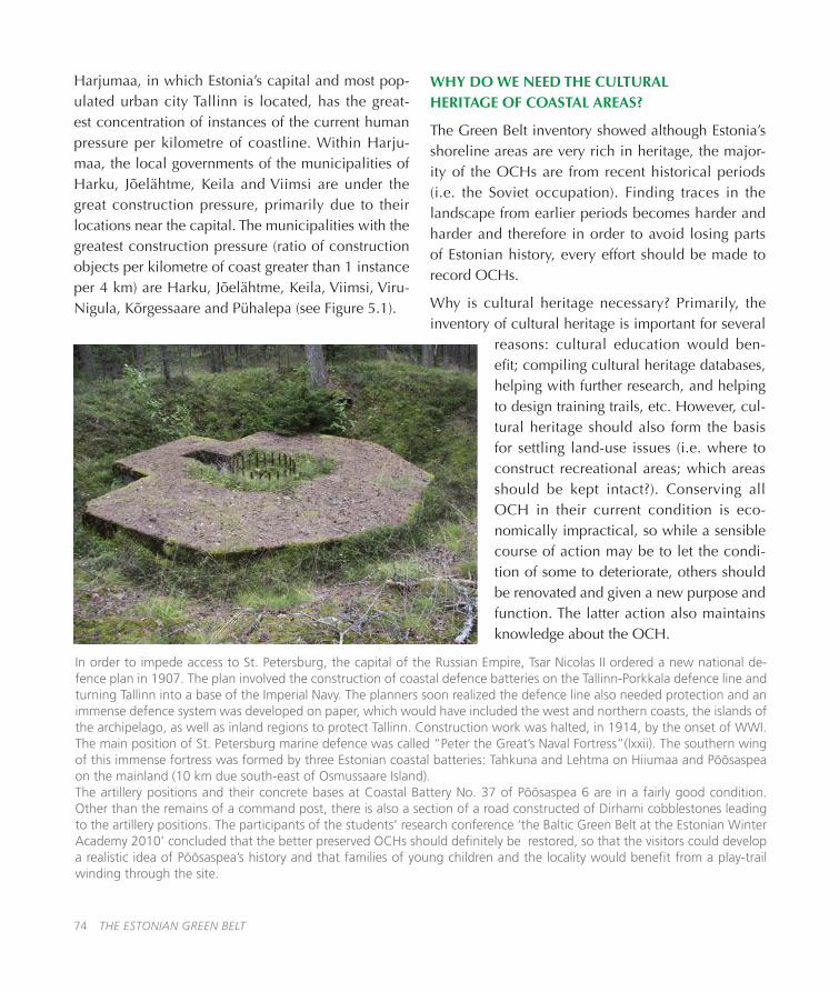
74 THE ESTONIAN GREEN BELT
Harjumaa, in which Estonia’s capital and most pop-ulated urban city Tallinn is located, has the great-est concentration of instances of the current human pressure per kilometre of coastline� Within Harju-maa, the local governments of the municipalities of Harku, Jõelähtme, Keila and Viimsi are under the great construction pressure, primarily due to their locations near the capital� The municipalities with the greatest construction pressure (ratio of construction objects per kilometre of coast greater than 1 instance per 4 km) are Harku, Jõelähtme, Keila, Viimsi, Viru-Nigula, Kõrgessaare and Pühalepa (see Figure 5�1)�
WHY DO WE NEED THE CULTURAL HERITAGE OF COASTAL AREAS?
The Green Belt inventory showed although Estonia’s shoreline areas are very rich in heritage, the major-ity of the OCHs are from recent historical periods (i�e� the Soviet occupation)� Finding traces in the landscape from earlier periods becomes harder and harder and therefore in order to avoid losing parts of Estonian history, every effort should be made to record OCHs�
Why is cultural heritage necessary? Primarily, the inventory of cultural heritage is important for several
reasons: cultural education would ben-efit; compiling cultural heritage databases, helping with further research, and helping to design training trails, etc� However, cul-tural heritage should also form the basis for settling land-use issues (i�e� where to construct recreational areas; which areas should be kept intact?)� Conserving all OCH in their current condition is eco-nomically impractical, so while a sensible course of action may be to let the condi-tion of some to deteriorate, others should be renovated and given a new purpose and function� The latter action also maintains knowledge about the OCH�
In order to impede access to St. Petersburg, the capital of the Russian Empire, Tsar Nicolas II ordered a new national de-fence plan in 1907. The plan involved the construction of coastal defence batteries on the Tallinn-Porkkala defence line and turning Tallinn into a base of the Imperial Navy. The planners soon realized the defence line also needed protection and an immense defence system was developed on paper, which would have included the west and northern coasts, the islands of the archipelago, as well as inland regions to protect Tallinn. Construction work was halted, in 1914, by the onset of WWI. The main position of St. Petersburg marine defence was called “Peter the Great’s Naval Fortress”(lxxii). The southern wing of this immense fortress was formed by three Estonian coastal batteries: Tahkuna and Lehtma on Hiiumaa and Põõsaspea on the mainland (10 km due south-east of Osmussaare Island).The artillery positions and their concrete bases at Coastal Battery No. 37 of Põõsaspea 6 are in a fairly good condition. Other than the remains of a command post, there is also a section of a road constructed of Dirhami cobblestones leading to the artillery positions. The participants of the students’ research conference ‘the Baltic Green Belt at the Estonian Winter Academy 2010’ concluded that the better preserved OCHs should definitely be restored, so that the visitors could develop a realistic idea of Põõsaspea’s history and that families of young children and the locality would benefit from a play-trail winding through the site.
THE ESTONIAN GREEN BELT 75
Normally OCHs are related to a specific ‘packet’ (of activity or aim, within a certain era, as a result of par-ticular societal processes), which means that restoring or preserving the entire ‘packet’ e�g� Tartu-Raadi Air-field as a highly visible and acoustic demonstration of the power (authority) of Communism and oppression is neither feasible nor desirable� Indeed military heri-tage is sufficiently emotive that society is only able to positively value military heritage objects (MHOs) when separated from the specific era by several gen-erations� However, MHOs need to be both protected and preserved, if only to serve as physical reminders of ‘man’s inhumanity to man’ within Estonian social-cultural history�
The inventory of OCHs provides a brief overview of the heritage of Estonia’s coastal areas and does not infer that all OCHs deserve equal protection� How-ever, the inventory does enable all ‘protection’ deci-sions to be based on comprehensively more knowl-edge than before� For example, every example of a numerous type of OCHs does not require preser-vation� The inventory enables decision makers to choose the best, most characteristic of the type adopt measures to preserve them� The inventory also helps decision-makers to estimate the uniqueness and thus the showcase value of every OCH�
A GENUINE HISTORY BOOK ON THE SHORE
Since the 13th century, many foreign powers have ruled Estonia, shaped the landscapes and society to their own desires, and have departed� The people, the natural environment and the culture of a nation in the 21st century is the sum of all previous socio-cultural invasions be they oppressive or benign� Nei-ther the process nor the outcome should be forgotten, even when the memories are still recent and painful� Each foreign power has aspects worthy of adoption and equally those necessary to avoid� Culture con-
sists of both the tangible (physical objects in natu-ral and man-made environments) and the intangible (customs, habits, skills, visual and acoustic arts)� Like-wise, cultural heritage also consists of the tangible and intangible but would remain incomplete without the preservation of the culture’s material output� The phrase ‘seeing is believing’ could have been coined for society’s relationship with cultural heritage�
Historically, coastal areas have always been related to human activity, historically as places to live and work and since the 19th century for having holi-days� As the inventory of coastal areas shows, coastal landscapes have an abundance of cultural heritage� Consequently, in the milieu of the 21st century the coasts are sites of conflict of interests between private interests and the need to conserve coastal landscape as a public good� The Estonian shoreline, like every other coast around the world, is an immense unfin-ished multi-coloured history book, which is definitely worthy of exploration and certainly worth keeping�
ENDNOTE
The length of the coastline of each local government was calculated by locating the intersection between the line of the Estonian Green Belt and the local gov-ernment’s administrative borders at the sea (Map of Estonian Administrative and Settlement Division as of 12�06�2009)�
The length of the coastline of a protected area was calculated by locating the intersection between the line of the Estonian Green Belt, according to Kalev Sepp (the editor of this volume) and the maritime bor-der of the protected area (EELIS as of 16�02�2011)�
76 THE ESTONIAN GREEN BELT
REFERENCES
i� Haapala, H�, Riitta, H�, Keinonen, E�, Lindholm, T�, Telkänranta, H�, 2003� Finnish-Russian nature conserva-tion cooperation� Finnish Ministry of the Environment and Finnish Environment Institute�
ii. Beck, P., Frobel, K., 1981. Letzter Zufluchtsort: Der “Todesstreifen”? Vogelschutz: Magazin für Arten- und Biotopschutz (2):24�
iii� Riecken U, Ullrich, K�, 2009� The origins of the European Green Belt – from the idea to the intiative, In: T� Wrbka, K, Zmelik and F� M� Grünweiss (Eds�) The European Green Belt,� Borders� Wilderness� Future� Vienna University: Bibliothek der Provinz�
iv� Maack, S�, 2009� Green Belt goes to Baltic – IUCN European Green Belt newsletter 1�
v� Lepassalu, V�, 2010� Riigipiir (State Boarder)� Tallinn: Pegasus (in Estonian)�
vi� Palginõmm, V�, Ratas, U� Kont, A�, 2007� Increasing human impact on coastal areas of Estonia in recent decades� Journal of Coastal Research, SI 50 (Proceedings of the 9th International Coastal Symposium), Gold Coast, Australia�
vii. Salo, V., Ennuste, Ü., Parmasto, E. Tarvel, E., Varju, P. (Eds.). 2005. The White Book. Losses inflected on the Estonian nation by occupation regimes 1940-1991� Tallinn: Estonian Encyclopaedia Publishers� Available at: http://www�riigikogu�ee/public/Riigikogu/TheWhiteBook�pdf Accessed 29�07�2011
viii� Regional Action Plan for Conversion in the Baltic Sea Region, 2006� Available at: http://www�conver�net/pdf/results/cvn_rap_81_72�pdf Accessed 29�07�2011
ix� Raukas, A� (Ed�), 2006� Nõukogude okupatsiooni poolt tekitatud keskkonnakahjud� Environmental damage caused by the Soviet occupation� Tallinn: Eesti Entsüklopeediakirjastus, 182 pp� (in Estonian, summaries in English and Russian)�
x� Hiiumaa Militaarajalooselts ja Hiiumaa militaarmuuseum Tahkunas http://www�mil�hiiumaa�ee/ and http://www�militaarmuuseum�ee/
xi� Raukas, A� (Ed�), 1999� Endise Nõukogude Liidu sõjaväe jääkreostus ja selle likvideerimine Past pollution of the Soviet Army in Estonia and its liquidation (in Estonian, with English summary)� Eesti Vabariigi Keskkonna-ministeerium, Tallinn, 192 pp�
xii� Raukas, A�, 2010� Sustainable development and environmental risks in Estonia� Agronomy Research 8 (Special Issue II), 351-356�
xiii� Nosov, V�, 1995� Environment problems in Sillamäe� – In: Ecological Security of the Baltic States, Nordic Countries and North-West Russia� Tallinn, 64-68�
xiv� Walker, M� I�, Rose, K�S�B�, 1990� The radioactivity of the sea� Nuclear Energy 29(4): 267-278�
xv� Kalam, J�, Rajamäe, R�, Ratas, R�, 1999� Sillamäe tööstuskompleks ja jäätmehoidla� Rmt�: In: A� Raukas 1999 (Ed�)� Endise Nõukogude sõjaväe jääkreostus ja selle likvideerimine (Past pollution of the Soviet Army in Estonia and its elimination)� Eesti Vabariigi Keskkonnaministeerium, Tallinn, 70-73�

THE ESTONIAN GREEN BELT 77
xvi� World Health Organization, 2009� Fact sheet N°291 Available at http://www�who�int/mediacentre/fact-sheets/fs291/en/index�html (Accessed 10�06�2011)
xvii� Kaasik, T�, 2006� Sillamäe jäätmehoidla oli ohuks kogu Läänemere regioonile� In: A� Raukas (Ed�)� Nõuk-ogude okupatsiooni poolt tekitatud keskkonnakahjud� Tallinn: Eesti Entsüklopeediakirjastus, 81-90 (in Esto-nian)�
xviii� Varvas, M�, Putnik, H�,Valge, J� (Eds�), 2005� Paldiski endise tuumaallveelaevnike õppekeskuse tuuma-objekt – üleandmine Eestile ja saastusest puhastamine� Paldiski: Majandus- ja kommunikatsiooniministeerium, A�L�A�R�A�, 100 pages�
xix� Sinisoo, M� 1995� Paldiski – radioactive waste and its disposal� – In: Ecological security of the Baltic States, Nordic Countries and North-West Russia� Tallinn, 81-88�
xx� Kink, H�, Metsur, M�, Miidel, A� 1995� Ecological security of the Pakri Peninsula� In: Ecological Security of the Baltic States, Nordic Countries and North-West Russia� Tallinn, 69-80�
xxi� Meriste, T� 1999 Paralepa lennuväli, In A� Raukas (Ed�) Endise Nõukogude Liidu sõjaväe jääkreostus ja selle likvideerimine� Keskkonnaministeerium: Tallinn (In Estonian)
xxii� Raukas, A� 2008� Uputatud keemiarelvadest Läänemere põhjas ja neist lähtuv oht� Eesti Mereakadeemia Toimetised 7, Tallinn: Eesti Mererakadeemia� 5-11� Reimann, M� 2010� Põhja-Kõrvemaa looduskaitseala kaitse-korralduskava 2011-2020� Tallinn: Keskkonnaamet (in Estonian)
xxiii. Raukas, A. 2005. Enormous environmental damage caused by occupation army. In: V. Salo, Ü. Ennuste, E. Parmasto, E.Tarvel, P. Varju (Eds.). The White Book. Losses inflicted on the Estonian nation by occupation regimes 1940-1991� Tallinn: Estonian Encyclopaedia Publishers, 133-139�
xxiv. LIFE Focus 2005. Natura 2000 and the military. Luxembourg: Office for Official Publications of the Euro-pean Communities�
xxv� Külvik, M�, Maiste, J (Eds)� 2009� Park on paradiis looduses ja kunstis� Tartu: Eesti Maaülikool�
xxvi� EEIC - Estonian Environment Information Centre� 2008� Estonian Nature Conservation in 2007� Tallinn, Estonian Environment Information Centre� http://www�keskkonnainfo�ee/publications/329_PDF�pdf�
xxvii� International Atomic Energy Agency� 2003 Uranium 2003� Resources, Production and Demand� OECD� pp128-129
xxviii� EEC 1979� Council Directive 79/409/EC on the Conservation of Wild Birds
xxix� EEC 1992� Council Directive 92/43/ EC on Conservation of Natural Habitats and of Wild Fauna and Flora
xxx� Estonian Nature Conservation Act (RT I 2004) https://www�riigiteataja�ee/akt/110062011005
xxxi� Estonian Environmental Register 2010� http://register�keskkonnainfo�ee
xxxii� Reimann, M�, Palang, H�, 1999� Competing Interests on a Former Military Training Area: a Case from Estonia� Forest Tourism and Recreation (Cabi Publishing): 41-54
xxxiii� Reimann, M�, 2010� Põhja-Kõrvemaa looduskaitseala kaitsekorralduskava 2011-2020� Tallinn:

78 THE ESTONIAN GREEN BELT
Keskkonna amet (in Estonian)
xxxiv� Heritage Conservation Act, RTI 2002, Muinsuskaitseseadus, 27, 153� Available: https://www�riigiteataja�ee/ert/act�jsp?id=13254453
xxxv� Karofeld, E� Tuhkatriinu Põhja-Kõrvemaalt� 1997� Eesti Loodus� http://www�loodusajakiri�ee/eesti_loodus/EL/vanaweb/9705/korvemaa�html
xxxvi� Napp, T� Kaitsealad Türisalus ja Väänas� 2001� Eesti Loodus� http://www�loodusajakiri�ee/eesti_loodus/EL/vanaweb/0103/tiina�html
xxxvii� Estonian Ministry of Environment� 2008� North Estonian Klint - Symbol of Estonian Nature� http://www�klint�envir�ee/klint/eng/index�html
xxxviii� Estonian Ministry of Environment� 2005� 95th Anniversary of Vilsandi National Park� http://www�envir�ee/87407
xxxix� Meikar, T� 2010� Naissaare looduskaitse ja metsad� Eesti Loodus� http://www�loodusajakiri�ee/eesti_loo-dus/artikkel3098_3078�html (In Estonian)
xl� Itse, B� 2005� Jalutuskäik saladusliku Naissaare lõunarajal� Eesti Loodus� http://www�loodusajakiri�ee/eesti_loodus/artikkel977_958�html (in Estonian)
xli� Estonian Environmental Board� 2006� Osmussaare landscape reserve� www�lk�envir�ee/aewa/upload/osmusaarevoldik_eng�pdf
xlii� Tallinn University of Technology� 2002� Conservation Management Plan of the Pakri Landscape Reserve� http://gaia�gi�ee/index�php?page=6&id=38
xliii� Vollmer, E�, Sepp, K�, Raet, J�, 2010� Estonian Green Belt: Values and Management Issues� Estonian University Life Sciences, Institute of Agricultural and Environmental Sciences, Estonia�
xliv� Tõnisson, A�, 2007� Laulasmaa maastikukaitseala kaitsekorralduskava 2007-2016� Tallinn: Riiklik Loodus-kaitsekeskus (in Estonian)�
xlv. Kirss, T. Kerge, S., 2010. Muraste looduskaitseala kaitsekorralduskava 2011-2020. 2010. Tallinn: OÜ Kes-kkonnakorraldus (in Estonian)�
xlvi� Müür, R�, 2005� Muraste looduskaitseala� Eesti Loodus� http://www�loodusajakiri�ee/eesti_loodus/artik-kel1289_1279�html
xlvii� Timm, U� Kiristaja, P�, 2005� Mäealuse maastikukaitseala – esimene kohalik� Eesti Loodus� http://www�loodusajakiri�ee/eesti_loodus/artikkel1186_1178�html (in Estonian)
xlviii� European Environment Agency, 2010 Nature protection and biodiversity (Estonia), Available at: http://www�eea�europa�eu/soer/countries/ee/soertopic_view?topic=biodiversity Accessed 29�07�2011
xlix� Kose, M�, Merivee, M�, Reinloo, A�, 2011� 15 aastat rannaniitude looduskaitselist hooldust Eestis� Eesti Loodus� http://www�loodusajakiri�ee/eesti_loodus/artikkel3659_3636�html (in Estonian)
l� Tepp, L�, 1993� Eestlaste võimalikust ja tegelikust arvust Eestimaal� // Eesti Statistika 11�
THE ESTONIAN GREEN BELT 79
li� Piirimäe, K� 2005� Tallinn on laiali valgunud� Eesti Päevaleht, 29�08�2005� http://www�epl�ee/artikkel/299362 (in Estonian)
lii� Raagmaa, G�, 2004� Tallinn valgub laiali��� Postimees, 17�07�2004� http://www�postimees�ee/180704/esileht/139545�php (in Estonian)
liii� Noorkõiv, R�, Sepp, V�, 2005� On the sprawl of Tallinn into Viimsi rural municipality: challenges of sub-urbanisation to a local government in the neighbourhood of the capital city� Cities and rural municipalities in numbers 2005. Tallinn: Statistical Office
liv� ICOMOS, ICTC, 2002 International Council of Monuments and Sites (2002) International Cultural Tourism Charter: p� 21 Available at http://australia�icomos�org/wp-content/uploads/ICOMOS-International-Cultural-Tourism-Charter-English�pdf Accessed on 25�06�2011
lv� Tarang, L�, 2007� Mets kui kultuurinähtus� Eesti metsades leiduva pärandkultuuri olukorrast ja hoiust [Forest as a Cultural Phenomenon� About the Condition and Preservation of the Heritage Culture Found in Estonian Forests]� In: Meikar, T� (Ed�) Väike pärandkultuuri käsiraamat [A Small Handbook of Heritage Culture]� Eesti Loodusfoto, Tartu, pp 9-11�
lvi� Leal Filho, W� (Ed�), 2006� Meetodid ajaloolise kultuuripärandi säilimiseks [Methods for the Preservation of Historical Cultural Heritage]� Castles of Tomorrow� Available: DIGAR, the archive of the National Library�
lvii� Palang, H�, 2001� Maastiku müüdid [Myths of Landscape]� Eesti Loodus [Estonian Nature]�
lviii� Parts, P-K�, 2007� Vaateid pärandimajandusele teoorias ja praktikas [Perspectives into Heritage Manage-ment in theory and practice]� Available: http://www�kirikiri�ee/article�php3?id_article=388
lix� Paulus, A�, 2010� Lahemaa ajaloolistest maastikest [About the Historical Landscapes of Lahemaa]� In: Pau-lus, A� (Compiler) Uurimusi Lahemaa ajaloolistest maastikest [Surveys into Historical Landscapes of Lahemaa]� Keskkonnaamet [Environmental Board], pp 5-8�
lx� Sepp, K�, Lõhmus, L�, 2010� Pärandkultuuri objektide ja rannikuala seisundi inventeerimine Euroopa rohevöös Eesti rannikualade näitel [Inventory of Objects of Heritage Culture and the Condition of the Coastal Area in European Green Belt, With an Eye to the Example of Estonian Coastal Areas� Eesti Maaülikooli Põl-lumajandus- ja Keskkonnainstituut [Institute of Agricultural and Environmental Sciences of the Estonian Uni-versity of Life Sciences]�
lxi� Kusmin, J�, 2009� Pärandkultuuri inventeerimise metoodika [Methodology for taking inventory of heri-tage culture]� Projekti „Metsanduslik pärandkultuur – ühise kultuuriruumi avardaja“ inventeerijate kooli-tus 03-04�03�2009, Mäetaguse� [Training of the inventory-takers of the project Forest Heritage Culture – an Expander of the Common Culture Space]�
lxii� Kaljuvee, R�, 2007� Pärandkultuuri süstematiseerimisest [About the systematization of heritage culture]� In: T� Meikar (Ed�) Väike pärandkultuuri käsiraamat [A Small Handbook of Heritage Culture]� Eesti Loodusfoto, Tartu, pp 14-17�
lxiii� Lõhmus, L�, 2010� Pärandkultuuri objektide inventuur ja kaitsekorralduse analüüs Eesti rohevöös [Inven-tory of Objects of Heritage Cultre and the Analysis of Protection Management in Estonian Green Belt]� Eesti
Maaülikooli Põllumajandus- ja Keskkonnainstituut (In Estonian)�
lxiv� Sinijärv, U�, 2005� Veekogu kaldale ehitamise õiguslik raamistik Eestis [Legal Framework for Building on a Bank of a Water Body in Estonia]� In: K� Peterson and O� Kuldna (Eds�) Rannaalade väärtused ja nende kaitse [Values of Coastal Areas and their Protection]� SEI väljaanne nr 7 [SEI Publication No�7], SEI-Tallinn, pp 16-18�
lxv� Riigikontroll, 2007�Ehitustegevus ranna- ja kaldaalal� Riigikontrolli aruanne Riigikogule [Report of the National Audit Office to the Parliament. Construction activity in shore and bank areas] Tallinn.
lxvi� Sarjas, A�, 2010� Juminda jubijäneksed: meie küla lood [Juminda Jubijäneksed: the Stories of Our Village]� Juminda külaselts [Juminda Village Society]�
lxvii� Kultuurimälestiste Riiklik Register [National Register of Cultural Monuments] 2011 What is the website URL?
lxviii� Õun, M�, 2010� Lahemaa merelahingud ja militaarmälestised [Naval Battles and Military Monuments of Lahemaa]� In: Paulus, A� (Ed�) Uurimusi Lahemaa ajaloolistest maastikest [Surveys into Historical Landscapes of Lahemaa]� Keskkonnaamet [Environmental Board], pp 139-156�
lxix� Kurepalu, A�, Kristenbrun, K�, 1994� Käsmu� [Käsmu]� Eesti Entsüklopeediakirjastus ja Lahemaa Rahvus-park [Estonian Encyclopaedia Publishers and Lahemaa National Park]�
lxx� Pärdi, H�, 2010� Lahemaa taluarhitektuuri muutumine ja eripära aastatel 1860-1940� Uusaegsed taluel-amud [Changes in and Peculiar Features of Lahemaa Farm Architecture in the Years 1860-1940� Modern farmhouses�]� In: Paulus, A� (Compiler) Uurimusi Lahemaa ajaloolistest maastikest [Surveys into Historical Landscapes of Lahemaa]� Keskkonnaamet [Environmental Board], pp 87-100�
lxxi� Välja, L�, 2010� Käsmu ja Võsu väärtuslikud miljööd [Valuable Milieus of Käsmu and Võsu]� In: Paulus, A� (Ed�) Uurimusi Lahemaa ajaloolistest maastikest [Surveys into Historical Landscapes of Lahemaa]� Keskkon-naamet [Environmental Board], pp 117–128�
lxxii� Kink, H�, 2008� Loodusmälestised� Natural heritage of Estonia� Läänemaa� Noarootsi, Nõva, Osmussaar� In: A� Miidel and A� Raukas (Eds) Teaduste Akadeemia Kirjastus [Estonian Academy Publishers], 43 pp�
lxxiii� Järv, H�, 2010� Estonian Green Belt – Pearl In The European Green Belt, Conference ‘Nature Conservation beyond 2010’ May 27-29, 2010 Tallinn, Estonia�

THE ESTONIAN GREEN BELT 81
GLOSSARY
An-12 – four engine turbo-propeller transport plane� The suffix An refers to Antonov�
Anketa – (Russian) a combination of an identity document and curriculum vitae�
Estonian SSR – Estonian Soviet Socialist Republic�
Commandanture, Border Guard – equal to a battalion
Day Marks (Daymark, Day marker) – distinctive, highly visible constructions set on islets, shorelines and coasts as navi-gational aids� Joint courses consisted of a pair of Day Marks set at different heights on the coast, which needed to be aligned for ships to gain safe passage� Pairs of lighthouses known as ‘range lights’ (USA) and ‘leading lights’ (UK) provide a similar function at night�
DOSAAF (The Voluntary Society of Assistance to the Army, the Air Force and the Navy) – was essentially under the juris-diction of the Soviet military during peacetime� Despite being, formally, an independent public organization, DOSAAF organizational structure was based on “democratic centralism”; the upper echelons of the hierarchy were generals and senior officers in active military service (not retired); its cars bore military number plates; it was financed by the Ministry of Defence, etc� However, its property did not belong to the Ministry of Defence (except maybe some of the better weap-onry), but to DOSAAF� Consequently, Estonian authorities do not view DOSAAF objects as military objects�
Expropriate administrative support staff (of the KGB) – people who worked/served somewhere else, but had to co-operate with KGB officers because of their positions, e�g� militiamen, enterprise directors/executives, but principally any member of the Communist Party�
Hanko, Finland – an element of the Moscow Peace Treaty that ended the Finno-Soviet Winter War in 1940, was that Finland leased Hanko as a military base to the Soviet Union for a period of 30 years� The Finno-Soviet Continuation War (June 1941-Sept 1944) forced the Soviet Union to withdraw its forces from Hanko in early December 1941� The Soviet Union, having gained the lease to Porkkala, agreed to renounce the Hanko lease formally at the Paris Peace Treaty in 1947�
Hanko and Porkkala were strategically important because the distance between the most southern artillery positions on the Finnish coast and the most northern on the Estonian coast was approximately 23 miles� This allowed the Soviets to control the Baltic Sea access to Leningrad� Porkkala had a secondary strategic role in that being no more than 19 miles from Helsinki, the Soviet Union could exert considerable influence on Finland�
Hanko and Porkkala after WWII were each part of one defence system� In 1940-41 the Hanko Naval Base was subordi-nated to the Baltic Fleet which was headquartered in Tallinn� In 1944-56 the Porkkala-Udd Naval Base was subordinated to the Baltic Fleet (later the Northern Baltic Fleet and 8th Naval Fleet) which was headquartered in Tallinn�
Independent (units) see Table 1.1 – Independent (detached) units (for example an independent battalion) did not belong to and often were not subordinate to a larger higher ranked unit (for example a regiment or division) but to a higher authority such as a Ministry� Within the military hierarchy, and Independent (detached) unit had a higher rank than their corresponding non-independent units�
Il-76MD – four engine multi-purpose airlift transport� The suffix Il refers to Ilyushin�
Joint course – see Day Marks
-maa – suffix is an abbreviation of maakond (Estonian) meaning ‘county’� There are 15 counties in Estonia: Harjumaa, Hiiumaa, Ida-Virumaa, Järvamaa, Jõgevamaa, Läänemaa, Lääne-Virumaa, Pärnumaa, Põlvamaa, Raplamaa, Saaremaa, Tartumaa, Valgamaa, Viljandimaa, Võrumaa� NB! The Estonian word for ‘land’ is ‘maa’ and in place names denotes a geographical area� Eestimaa – land of the Estonians; Maramaa – is a residential area close to Tartu�
MARS-75 – Maritime Automatic Radio-navigation System
MHO – military heritage object
Nuclear Warheads in Estonia – The argument there were nuclear warheads on Estonian soil between 1946 and 1991 is debatable� The commonly voiced counter arguments being that the Soviet Union never admitted to having deployed or stored nuclear warheads in Estonia and there are not any extant Soviet documents relating to the presence of nuclear warheads in Estonia�
One argument for the presence of nuclear warheads in Estonia is based on the presence of specially built bunkers for stor-

ing nuclear warheads, and airborne systems (aircraft and missiles) capable of delivering nuclear warheads� The counter argument is that the ability to store and launch nuclear warheads does not indicate the presence of nuclear warheads�
Another argument is that among the thousands of military personnel staffing the Strategic Rocket Force units and Air Force Bomber units (the units most likely to deliver nuclear warheads) were Estonians, who with the restitution of independence in 1991 could begin to talk about their experiences and occasionally receive coverage in newspapers� The counter arguments are that verbal (anecdotal) evidence is highly variable and unsupported by documentary data and that newspaper coverage does not add weight to the veracity of the story�
Anecdotal evidence is, however, the most likely method of settling the issue� But only if the stories are documented (either written down, or recorded and transcribed) and archived� Archived memories carry more weight with research-ers who can refer to the documents� This is particularly true if there are numerous documented memories referring to a specific topic�
OCH – Object of Cultural Heritage
Polygon – military training area
Porkkala (Porkkala-Udd Naval Base), Finland – (see Hanko) Porkkala, Porkkala-Udd Naval Base, Finland – (see also Hanko) An element of the treaty that ended the Finno-Soviet Continuation War was the agreement by Finland to lease the Porkkala Peninsula to the Soviet Union for 50 years� In effect Porkkala replaced Hanko� The Soviet Union agreed to relinquish control of Porkkala in 1955 and handed the territory back to Finland in 1956�
Sea Marks – see Day Marks
Su-24 – all-weather attack aircraft� The suffix Su refers Sukhoi�
Troops – arm of service, lower rank of Soviet armed forces�
Border (Guard) Troop – equivalent to regiment�
Tu-4 – four piston engine bomber ‘reverse engineered’ on the USAAF B-29 SuperFortress bomber� The suffix Tu refers to Tupolev�
Tu-16 – Twin turbo-jet long distance bomber� The suffix Tu refers to Tupolev�
Tu-22M3 – supersonic, swing-wing, long-range strike bomber / cruise missile carrier� The suffix Tu refers to Tupolev�
Vald - Parish – an administrative unit in Estonia, which unlike the English-language word is not linked to the presence of a church�
WWI – World War I
WWII – World War II – 1939-1945 globally, i�e� including all ‘theatres of war’� In Estonia, although the fighting ended in late 1944, the state of martial law remained in force till May 1945�

THE ESTONIAN GREEN BELT 83
Zone I
Strat. Rocket Forces
EPS 4,000
Land Forces
Estimated Peak Strength 20,000
Air Defence Forces
Estimated Peak Strength 9,000
Navy
Estimated Peak Strength 16,000
Air Forces
Estimated Peak Strength 8,000
KGB Border Guard
Estimated Peak Strength 6,000
Other troops Estimated Peak Strength 21,000
1 Guards Motorized-Rifle Division (1960-94)
2 Guards Motorized-Rifle Divisions (1957-60)
1 Independent Signals intelligence (SIGINT) Centre (until 1992) with 2 Independent SIGINT Companies
1 Independent Radio Direction Finding Centre (until 1992)
1 Heavy-Howitzer Artillery Brigade (in mid-1980s)
1 Independent Tank Battalion (until 1980)
1 Training Centre of the Baltic Military District (until the 1970s)
1 Fuel and 1 Food Depot of the Baltic Military District
2 SAM Brigade HQs
28 SAM Battalions*
1 Interceptor Aviation Regiment (1957-70)
3 Interceptor Aviation Regiments (1957-60)
1 Radar Brigade HQ 1963-93 (2 Regiments’ HQ 1957-60, 1 Regiment’s HQ 1960-63)
9-6 Radar Battalions or Companies
3 Anti-Aircraft Artillery Regiments (until 1959)
1 Anti-Aircraft Artillery Division HQ (until 1958)
1 Guards Minesweeper Brigade,
1 Independent Guards Anti-submarine Squadron
1 Independent Squadron of Ships Under Repairs,
50+ Escort & Anti-submarine, Minesweepers, etc.
1 Independent Guards Missile Boat Squadron with 10 Fast Attack Boats
1 Submarine Brigade with 15 Submarines
1 Auxiliary Fleet Department with over 30 Support & Rescue Vessels
1 Destroyer Brigade (until 1970s), up to 11 Destroyers (1958)
7-5 Ordnance Factories
20-15 Rear Depots
1 Naval Submarine Training Centre (until the 1960s for diesel submarines; later 2 mock-up nuclear submarines with working nuclear reactors)
1 Naval Aviation Regiment (1989-92)
1 Naval Reconnaissance Troop
1 Naval Physical Fields’ Testing Range
1 Naval Communications Testing Range
1 Independent Communications Battalion
1 Coastal Artillery Brigade (3 Independent Battalions, up to 15 Batteries, until 1960)
1 Bomber Aviation Regiment (1983-1989)
1 Fighter-bomber + 1 Bomber Regiment (1983-84)
2 Interceptor Aviation Regiments (1977-1983)
1 Fighter-Bomber Aviation Regiment (1967-77)
1 Repair Technical Base
2 Border Troops’ (Regiments’) HQ
48-28 Border Guard Stations
1 Independent Border Guard Ship Brigade
1 Military Construction Political College
5-10 Construction Departments with subordinated Military Construction Battalions
1 Independent Civil Defence Regiment
2 Independent Railroad Battalions
1 Military Construction Regiment
1 Convoy Regiment
1 Special Motorized Militia Regiment 1989-91 (Independent Battalion 1966-89)
APPENDICES
APPENDIX 1
Table 1.1 (Zones I – IV): Core Soviet Military Units of the Baltic Military District, Locations and Estimated Peak Strengths in the Security Zones (see Figure 1.1) and the Hinterland of the Estonian SSR 1957-1994

84 THE ESTONIAN GREEN BELT
Zone
Strategic Rocket Forces EPS 4,000
Land Forces
Estimated Peak Strength 20,000
Air Defence Forces
Estimated Peak Strength 9,000
Navy
Estimated Peak Strength 16,000
Air Forces
Estimated Peak Strength 8,000
KGB Border Guard
Estimated Peak Strength 6,000
Other troops Estimated Peak Strength 21,000
II
1 Independent SIGINT Centre (until 1992)
1 Motorized-Rifle Division (1958-60)
1 Independent Tank Battalion (late 1950s)
1 SAM Brigade HQ
16 SAM Battalions1
1 Radar Battalion and 4-5 Radar Companies
1 Radar Regiment or Independent Centre (1957-63)
1 Coastal Artillery Brigade (3 Independent Battalions, up to 12 Batteries, until 1960)
1 Machine Gun Artillery Division (1947-58)
1 Naval Aviation Reserve Aerodrome Commandanture (1970-80s)
1 Naval Aviation Division with 2 Regiments (until 1958?)
1 Border Troops (Regiments) HQ
33-14 Border Guard Stations
III
1 Chemical Defence Brigade (1990-92; earlier Regiment, Independent Battalion)
1 SAM Battalions’ Group HQ
6 SAM Battalions1
2 Interceptor Aviation Regiments (1970-77, 1986-92)
1 Interceptor Aviation Regiment (1961-77, 1986-92)
2 Radar Battalion HQs
1 SIGINT Centre (until 1992)
1 Naval Aviation Regiment (1957-60)
2 Interceptor Aviation Regiments (1977-86)
1 Independent Border Guard Ship Squadron (non-independent 1963-92)
1 Aviation Regiment/Squadron (until 1960)
IV
4 Guards Rocket Regiments:
1 static ‘silo’ Rocket Battalion
8 semi-mobile Rocket Battalions
4 Repair Technical Base
1 Independent Airborne Assault Battalion
1 Anti-Aircraft Artillery Training Regiment
1 Howitzer Artillery Regiment (late 1950s)
1 SAM Regiment HQ (1960-92)
1 SAM Brigade HQ (1961-79)
11-15 SAM Battalions1
1 temporary SAM Battalion1 (about 1985)
1 Radar Battalion and 2 Radar Companies
1 Mobile Repair Technical Base
1 Interceptor Aviation Regiment (1954-77, 86-93)
2 Interceptor Aviation Regiments (1954-61)
1 Interceptor Aviation Division HQ (1954-59)
1 Helicopter Squadron (1989-1992)
1 Radar Battalion and 2-1 Radar Companies
1 Radar Regiment HQ and 3-2 Radar Companies (1957-63)
2 Naval Aviation Reserve Aerodrome Commandantures
1 Heavy Bomber Aviation Divisions HQ
1 Heavy Bomber Aviation Regiment
1 Interceptor Aviation Regiment (1977-86)
1 Military Transport Aviation Regiment
1 Aviation Repair Factory
1 Repair Technical Base
2 Reserve Aerodrome Commandantures
1 Diversionary (Spetsnaz) Brigade (1963-92)
1 Engineer Training Brigade (1963-92)
1 Airborne Division with 2 Regiments (until 1960)

THE ESTONIAN GREEN BELT 85
APP
END
IX 2
Airf
elds
and
maj
or m
ilita
ry a
viat
ion
units
in E
ston
ia a
nd in
the
nei
ghbo
urho
od (i
n ab
out
1986
)
Gu
lf o
fR
iga
Gu
lf o
f F
inla
nd
Lake
Peip
si
Ba
ltic
Se
aE
STO
NIA
FIN
LA
ND
RU
SSIA
NFE
DE
RA
TIO
N
LA
TV
IA
LA
TV
IA
025
50 k
m
Tart
uPä
rnu
Ruh
nu
Kihn
u
Vilja
ndi
Nar
vaO
lgin
a
Jõhv
i
Rut
ja
Nur
msi
Võhm
aVi
rtsu
(Tuu
di)
Kogu
la
Aste
Ämar
i
Smur
avjo
vo
Prom
ežitsõ
Obr
iku
Liep
a
Rõi
ka
(Kirn
a)
Rid
ali
Suur
-Pak
ri Kuus
iku
Koht
la-
Järv
e
Paid
e
Rap
la
Jõge
va
Tapa
Haa
psal
u
Valg
aVõ
ru
Valm
iera
Ikla
Ruj
iena
Rak
vere
Vent
spils
Kalla
ste
Kure
ssaa
re
Kärd
la
Slan
tsy
Psko
v
Gdo
v
Ivan
goro
d
Hel
sink
i
Tal
linn
nava
l avi
atio
n ai
r�el
ds
air d
efen
ce a
viat
ion
air�
elds
air f
orce
s ai
r�el
ds
avia
tion
club
s
divi
sion
hea
dqua
rter
s
rese
rve
air�
eld
supp
ortin
g un
itsre
pair
tech
nica
l bas
e (fo
rnu
clea
r bom
bs a
nd w
arhe
ads)
avia
tion
garr
ison
400-
750
m
soft
sur
face
land
ing
strip
(sof
t sur
face
)
hard
sur
face
(asp
halt,
con
cret
e)
land
ing
strip
on
a pa
ved
road
800-
1500
m
2000
-250
0 m
3000
-350
0 m
AIR
FIEL
DS:
Runw
ay le
ngth
:
Runa
way
cha
ract
er (l
ine
show
s th
e ru
nway
dire
ctio
n):
bord
er g
uard
air�
elds
DO
SAA
F ai
r�el
ds
civi
lian
air�
elds
bom
bing
rang
es
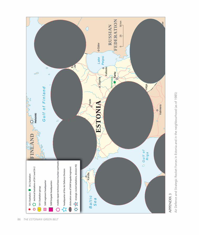
86 THE ESTONIAN GREEN BELT
APP
END
IX 3
Air
Def
ence
and
Str
ateg
ic R
ocke
t Fo
rces
in E
ston
ia a
nd in
the
nei
ghbo
urho
od (a
s of
198
5)
Gu
lf o
fR
iga
Gu
lf o
f F
inla
nd
Lake
Peip
si
Ba
ltic
Se
aE
STO
NIA
FIN
LA
ND
RU
SSIA
NFE
DE
RA
TIO
N
LA
TV
IA
LA
TV
IA
025
50 k
m
Tart
uPä
rnu
Vilja
ndi
Nar
vaKo
htla
-Jä
rve
Paid
e
Rap
la
Jõge
va
Tapa
Haa
psal
u
Valg
aVõ
ru
Valm
iera
Ikla
Ruj
iena
Rak
vere
Vent
spils
Kalla
ste
(tem
pora
ry)
Kure
ssaa
re
Kärd
la
Slan
tsy
Kjor
stov
o
Psko
v
Aluk
sne
Ost
rov
Gdo
v
King
isep
p
Hel
sink
i
Tal
linn
SA-3
bat
talio
n
SA-5
bat
talio
n gr
oup
SAM
regi
men
t hea
dqua
rter
SAM
brig
ade
head
quar
ters
mob
ile re
pair
tech
nica
l bas
e (n
ucle
ar w
arhe
ads)
head
quar
ter o
f the
Air
Def
ence
Div
isio
n
disl
ocat
ion
area
of S
AM
brig
ade/
regi
men
t
stra
tegi
c ro
cket
bat
talio
ns, d
ivis
ion
HQ
SA-2
bat
talio
n
tech
nica
l bat
talio
ns o
f SA
-3 a
nd S
A-2

THE ESTONIAN GREEN BELT 87
APP
END
IX 4
Maj
or u
nits
of
the
Stra
tegi
c Ro
cket
For
ces
in E
ston
ia a
nd in
the
nei
ghbo
urho
od (1
977)
Gu
lf o
fR
iga
Gu
lf o
f F
inla
nd
Lake
Peip
si
Ba
ltic
Se
aE
STO
NIA
FIN
LA
ND
RU
SSIA
NFE
DE
RA
TIO
N
LA
TV
IAL
AT
VIA
025
50 k
m
Tart
uPä
rnu
Vilja
ndi
Nar
vaKo
htla
-Jä
rve
Paid
e
Rap
la
Jõge
va
Tapa
Haa
psal
u
Valg
aVõ
ru
Valm
iera
Aluk
sne
(act
ual l
ocat
ion
20 k
m s
outh
)O
stro
v
Ikla
Ruj
iena
Rak
vere
Vent
spils
Kalla
ste
Kure
ssaa
re
Kärd
la
Slan
tsy Ps
kov
Gdo
v
King
isep
p
Hel
sink
i
Tal
linn
RH
/MR
RH
/MR
RH
/MR
RH
/MR
RH
/MR
RH
/MR
STR
ATE
GIC
RO
CK
ET
FOR
CE
S
regi
men
t hea
dqua
rter
&m
obile
repa
ir te
chni
cal b
ase
HQ
divi
sion
hea
dqua
rter
s
stra
tegi
c ro
cket
bat
talio
n
silo
-bas
ed ro
cket
bat
talio
n
RH
/MR