The Earth is not a sphere: The horizontal component of geodesy Dr. Dru Smith Chief Geodesist,...
18
The Earth is not a sphere: The Earth is not a sphere: The horizontal component The horizontal component of geodesy of geodesy Dr. Dru Smith Chief Geodesist, National Geodetic Survey National Science Teacher’s Association St. Louis, MO March 31, 2007
-
Upload
lynette-maxwell -
Category
Documents
-
view
215 -
download
2
Transcript of The Earth is not a sphere: The horizontal component of geodesy Dr. Dru Smith Chief Geodesist,...

The Earth is not a sphere:The Earth is not a sphere:The horizontal component The horizontal component
of geodesyof geodesy
Dr. Dru SmithChief Geodesist, National Geodetic Survey
National Science Teacher’s AssociationSt. Louis, MO
March 31, 2007

Learning Outcomes
• Understand the general size and shape of the Earth– And how this has changed through history
• Understand the importance of accurately knowing the size and shape of the Earth– And how this importance has changed over time
• Define geodesy, latitude and longitude
• Explain the difference between magnetic north and true north

Geodesy and other Geo-sciences
• Geodesy is an Earth Science
• Other familiar Earth (or Geo-) sciences and what they study:– GEOgraphy: What is found where on Earth– GEOlogy: Rock formations of Earth– GEOphysics: Physical forces that shape Earth– GEOmorphology: Landforms and their evolution

What is Geodesy?
• The scientific study of– the size and shape of the Earth, – its gravity field, – the precise determination of positions on the Earth’s surface and – the measurement of geodynamic phenomena
• such as the motion of the magnetic poles,• tides and • tectonic plate motion.
– From a mix of definitions• American Heritage Science Dictionary• Webster’s New Collegiate Dictionary

History of Geodesy – Shape of the Earth (1)
• 9th century BCE (Homer)– “Flat Earth with hemispherical sky”
• 6th century BCE (Pythagoras)– “Spherical Earth”
• As a “perfect form”• No scientific deduction
• 4th century BCE (Aristotle)– “Spherical Earth”
• Deduction from horizon issues

History of Geodesy – Shape of the Earth (2)
• 230 BCE (Eratosthenes)– First computation of Earth Radius!!
• Off by only a few percent
• (1492? Has nothing to do with flat vs. round)
• 17th century CE (L’Academe Royale de Sciences) – “the Cassinis”– Ellipsoidal Earth (prolate)
• 17th century CE (Sir Isaac Newton)– Ellipsoidal Earth (oblate)

Eratosthenes’ experiment
Known: At noon, on the summer solstice, the sun was reflected on the water at the bottom of a well in Syene. (e.g. “the sun was directly overhead”)
But…in Alexandria, a column cast shadows at that time (e.g. “the sun was not directly overhead”)
Measured: Column height Column shadow Distance from Syene to Alexandria
Assumed (all ok for 250 BCE): (1) Syene on Tropic of Cancer (2) Alexandria due north of Syene (3) The sun’s rays are parallel to each other

History of Geodesy – Shape of the Earth (3)
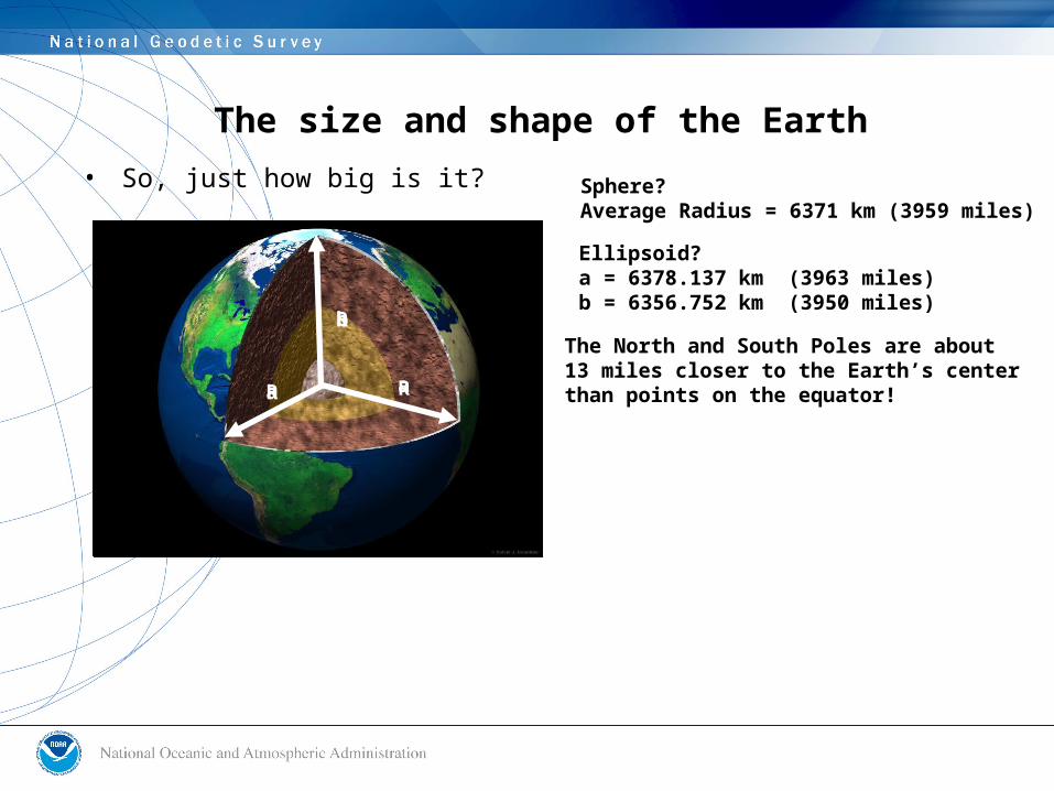
The size and shape of the Earth
• So, just how big is it?
R
R R
Sphere?Average Radius = 6371 km (3959 miles)
b
a a
Ellipsoid?a = 6378.137 km (3963 miles)b = 6356.752 km (3950 miles)
The North and South Poles are about13 miles closer to the Earth’s centerthan points on the equator!

The size and shape of the Earth
• Even an ellipsoid isn’t the true Earth shape
• 1888 G.G. Stokes proposed a new, better “figure (shape) of the Earth”, – “The geoid”– Basically the ocean surface, if you take away
tides, and circulation and let it be still

Figure of the Earth – The geoid
Yes, the ocean surface does “dip” toward the center of the Earth in the Indian Ocean
…and it “swells” away from the center of the Earth nearNew Guinea

The size and shape of the Earth – so what?
• Columbus’ voyage– He had computed the wrong size of the Earth!
• The geoid– To know “height above sea level” (helps if you live in
a city near sea level, like New Orleans)
• Last 20 years: Changes to Earth shape are studied– Tectonic movements, Earth Tides, length of day
• Nowadays, most of geodesy concentrates on the positioning side and less on size/shape issues– Positioning requires a coordinate system…
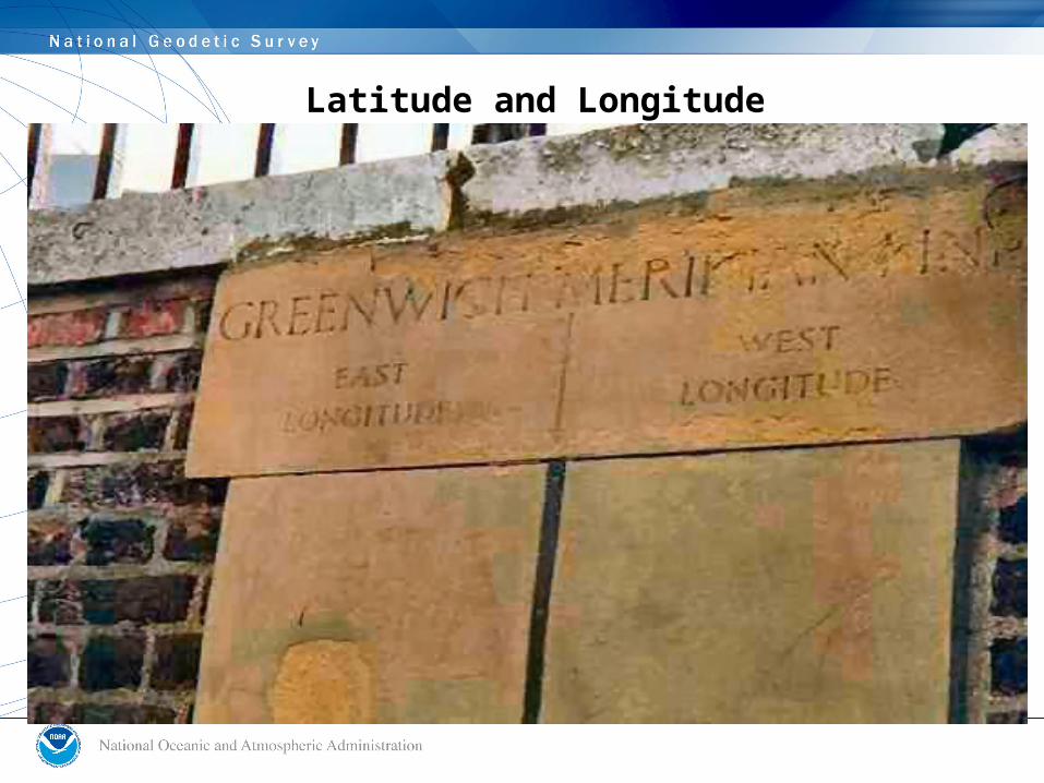
Latitude and Longitude
North Pole“Spin Axis”
Equator
“EquatorialPlane”
(The one and only)
“GreenwichMeridional
Plane”
Greenwich or PrimeMeridian(Passes throughGreenwich, England)
“MeridionalPlane”
(Any oneof many)
LONGITUDELati
tud
e
Latitude and Longitude
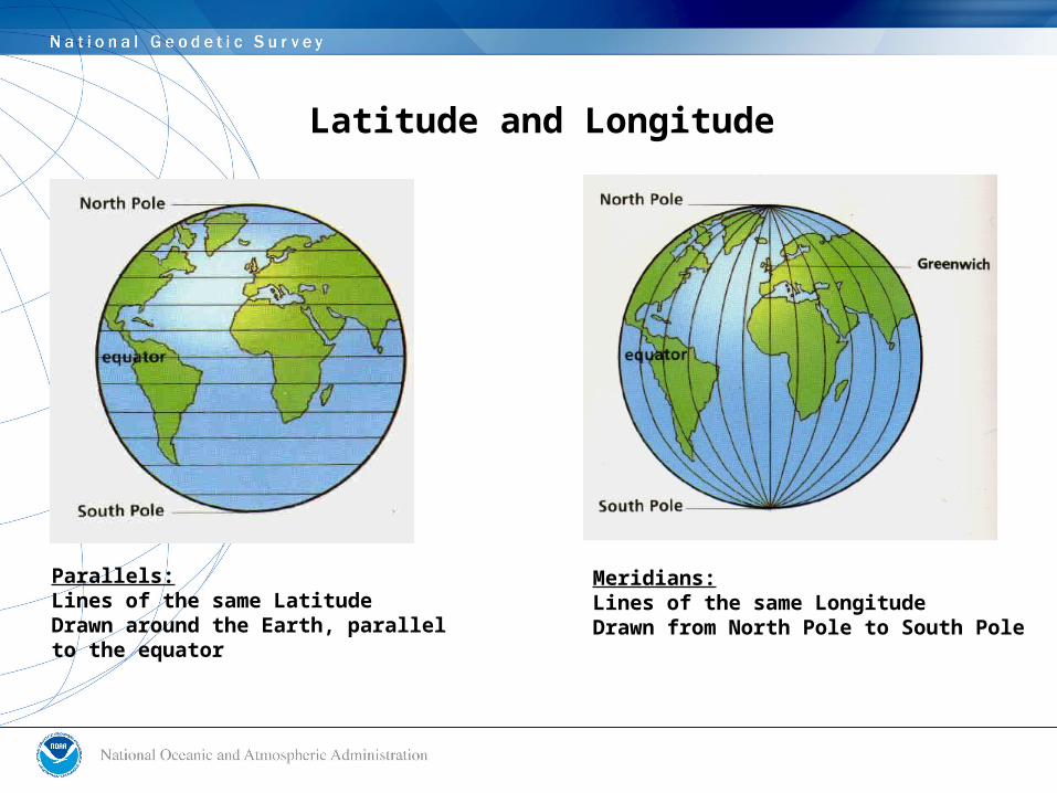
Meridians:Lines of the same LongitudeDrawn from North Pole to South Pole
Parallels:Lines of the same LatitudeDrawn around the Earth, parallelto the equator

Latitude and Longitude

Magnetic North
• Quasi-truth: “A compass needle points North”– Generally ok for the USA
• Except Alaska!! (Points ~Northeast!)– “True North Pole” is generally the place where the
spin axis intersects the Earth
• Truth: “A compass needle points towards the north magnetic pole”– Which lies in north-central Canada– And wanders hundreds of miles over the centuries

The wander of the north magnetic pole

Questions?
• Dr. Dru Smith• Chief Geodesist, National Geodetic Survey
• [email protected]• 301-713-3222 x 144