The Designation of Routeing Measures in Lombok and Sunda … The Designation of Routeing... ·...
13
The Designation of Routeing Measures in Lombok and Sunda Straits 11 th COOPERATION FORUM SINGAPORE 24 - 25 SEPTEMBER 2018
Transcript of The Designation of Routeing Measures in Lombok and Sunda … The Designation of Routeing... ·...

The Designation of Routeing Measures in Lombok and Sunda Straits
11th COOPERATION FORUMSINGAPORE
24 - 25 SEPTEMBER 2018

Methodology Study For TSS
2
Data Collection and Analysis
Design Scenarios of Ship’s Routeing
Hazard Identification
Risk Assessment (IWRAP )
Proposed Ship’s Routeing System

3
PROGRES DESIGN TSS LOMBOK
AND SUNDA STRAITS

PROGRES DESIGN TSS LOMBOK STRAITS
The Revised Proposed TSS Lombok Strait
• with The proposed TSS, two Precautionary Areas and
Full TSS ;
• Lombok Strait is designated as Indonesian
Archipelagic Sea Lanes (IASL) II;
• 3.0 NM wide TSS separated by 0.3 NM separation
zone in Lombok Strait as a main shipping lane for
national and international route at the northern
entrance of Lombok Strait;
• The total length of the TSS is approximately 4.9 NM
which lies between northern bound and proposed
northern precautionary area;
• a southern precautionary area with recommended
directions of traffic flow, that lies on the proposed
southern TSS with the length approximately 4.62 NM;
• The total length of the proposes southern TSS is
approximately 13.9 NM.
The Prelimenary Proposed TSS Lombok Strait :
• with two Precautionary Areas and two Inshore
Traffic Zones :
• Lombok Strait is designated as Indonesian
Archipelagic Sea Lanes (IASL) II;
• two nautical wide TSS in Lombok Strait as a
main shipping lane for national and
international route which extend approximately
42 nautical miles from the southern entrance to
northern entrance of Lombok Strait
• southern Precautionary Area that lies
approximately 19.2 nautical miles to the north
of southern entrance of TSS of Lombok Strait.
The southern Precautionary Area extends
approximately 4.6 nautical miles and 2 nautical
miles
• Inshore Traffic Zone that lies from TSS to the
west (east coast of Bali Island) and to the east
(west coast of Lombok Island)

• The objectives for submitting the proposed routeing system are to establish a
new TSS, two Precautionary Areas, and two Inshore Traffic Zones in Lombok
Strait which are located within Bali Island and Lombok Island;
• The designation of TSS with two Precautionary Areas is to ensure that all ships
will obtain adequate information concerning the surrounding traffic. Hence, the
designated TSS would reduce the likely ship collision on the route, by providing
the separation scheme between two way routes and two Precautionary Areas
for the intersection routes.
• reduce the number of head-on situations to increases the safety of navigation,
by separating opposing traffic streams in the area;
• reduce, if not eliminate, the risk of crossing collision between ships by
recommending precautionary area;
• contribute to safety and efficiency of navigation and/or protection of the marine
environment in water area of Lombok Strait.
Objectives of TSS Lombok Strait:

The Map of Lombok Strait
6

The Revised Proposed TSS Lombok Strait
• 2.67 NM wide TSS separated by 0.3 NM wide separation
zone, which lies between northern entrance of TSS and
proposed precautionary areas. The total length of the TSS is
approximately 2.6 NM which lies between the southern bound
and proposed precaution area;
• a precautionary area located within the proposed TSS,
approximately located 2.67 NM from the northern entrance of
TSS to about 1.2 NM to the south;
• 1.2 NM wide TSS in Sunda Strait, which lies between
proposed precautionary areas and southern entrance, and act
as a main shipping lane at the southern entrance of Sunda
Strait. The total length of the proposes southern TSS is
approximately 4 NM ;
• inshore traffic zone that lies from TSS to the west coast of
Lampung;
• the proposed ATBA to prevent the ships sail close to the Koliot
Reef
The Preliminary ProposedTSS Sunda Strait :
• a precautionary area located between the TSS, approximately located 3.12 nautical miles from the
northern entrance of TSS and 4.27 nautical miles from the southern entrance of TSS;
• one nautical mile wide TSS in Sunda Strait which act as the main routing system for especially international shipping. The total length of the TSS
is approximately 9.38 nm which lies between the southern bound and northern bound of the sea
water area;• inshore traffic zone that lies from TSS to the west
to the east coast of Lampung;
PROGRES DESIGN TSS SUNDA STRAITS

Objectives of TSS Sunda Strait:
▪ Sunda Strait lies between Java Island and Sumatra Island. This Strait connects IndianOcean and Java Sea. Sunda Strait is one of the most important strait in Indonesia which lies a ship traffic lane categorized as IASL I from southbound to northbound of Sunda Strait while there is a high density crossing lane from Java Island and Sumatra Island that mainly passenger vessels utilize. The IASL is also adopted by the IMO through resolution MSC.72(69) in 1998.
▪ reduce the number of head-on situations to increase the safety of navigation, by separating opposing traffic streams in the area;
▪ reduce, if not eliminate, the risk of accidental ship grounding by keeping ships well away from the coral reef atolls of Terumbu Koliot;
▪ reduce, if not eliminate, the risk of collision between ships by recommending one precautionary area;
▪ ensure that ships follow routes absolutely free from the known dangers posed by the coral reef atolls of Terumbu Koliot by recommending ATBA.
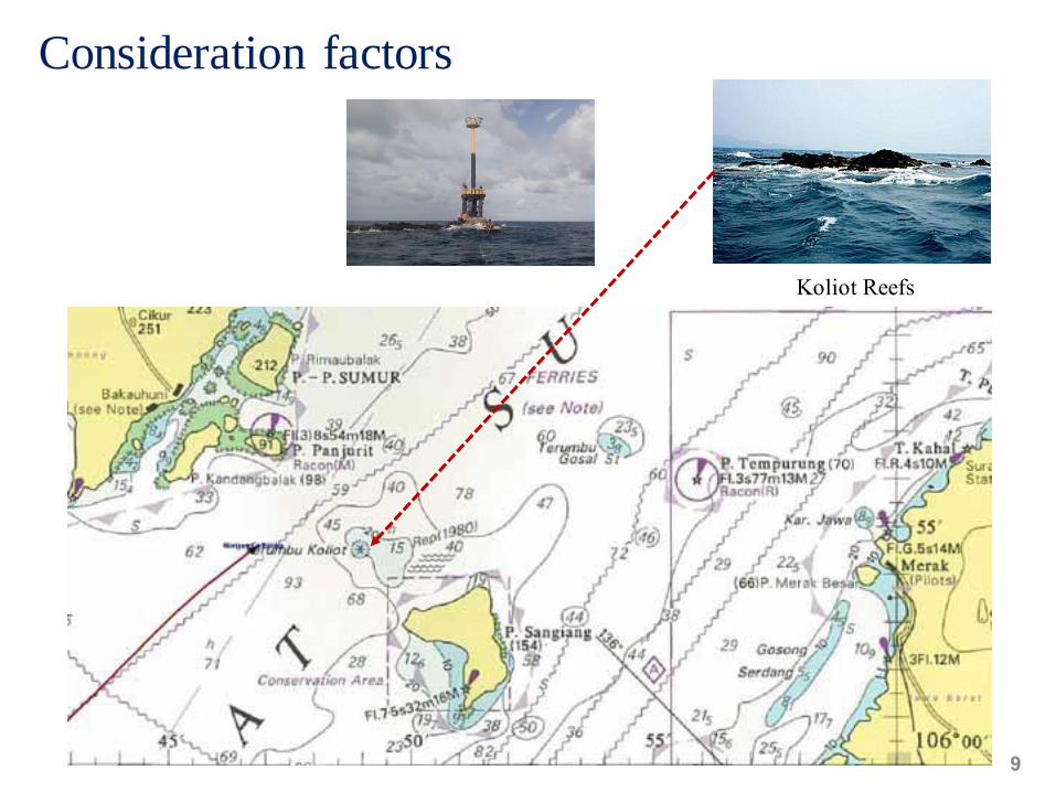
Consideration factors
9
Koliot Reefs

The Proposed Design Routeing Measures in Lombok and Sunda Straits
10
Sunda StraitLombok Strait

Status of routeing systems
▪ As an IMO adopted TSS, all vessels will be subject to the provision of rule 10 of COLREG 1972.
▪ If vessel fails to comply with the measures on designated ship routeing system, appropriate actions will be taken, including interaction with the flag state, in accordance with relevant IMO regulations.
▪ The proposed TSS can be reasonably expected to reduce the risk of collision, reduce and delay the risk of pollution or other harm to the marine environment
11
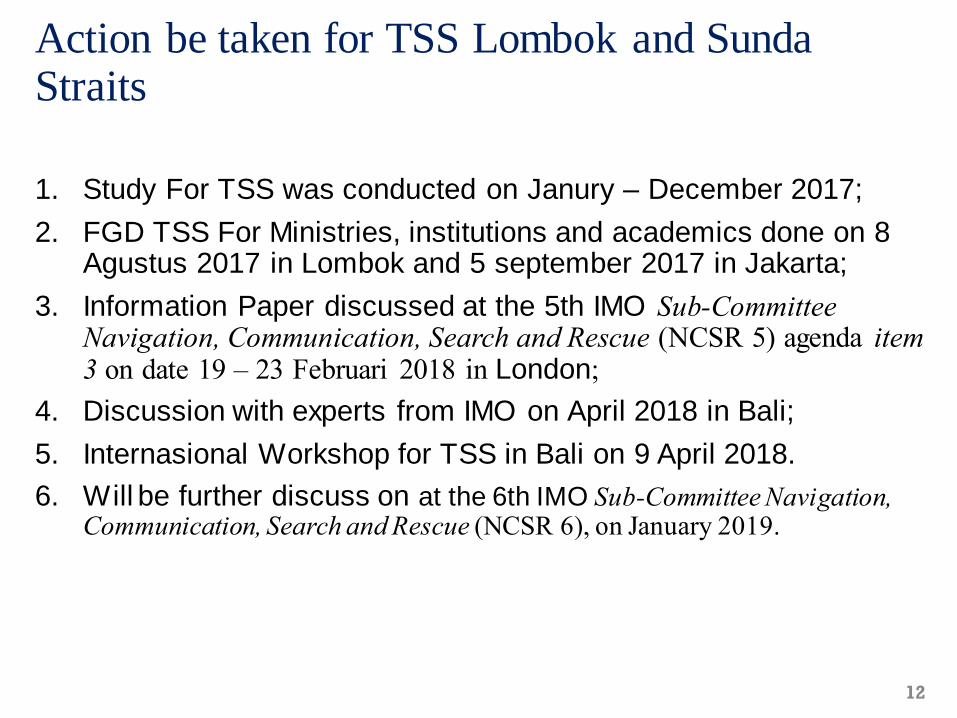
Action be taken for TSS Lombok and Sunda Straits
1. Study For TSS was conducted on Janury – December 2017;
2. FGD TSS For Ministries, institutions and academics done on 8 Agustus 2017 in Lombok and 5 september 2017 in Jakarta;
3. Information Paper discussed at the 5th IMO Sub-Committee Navigation, Communication, Search and Rescue (NCSR 5) agenda item 3 on date 19 – 23 Februari 2018 in London;
4. Discussion with experts from IMO on April 2018 in Bali;
5. Internasional Workshop for TSS in Bali on 9 April 2018.
6. Will be further discuss on at the 6th IMO Sub-Committee Navigation, Communication, Search and Rescue (NCSR 6), on January 2019.
12

Thank You
13