The Cultural Value of Bakuts in Kampong Ayer, Brunei...
17
Southeast Asia: A Multidisciplinary Journal, Vol 19, 2019, pp 47–63 © FASS, UBD The Cultural Value of Bakuts in Kampong Ayer, Brunei Darussalam Noor Hasharina Hassan and Gabriel Y. V. Yong Universiti Brunei Darussalam Abstract Bakuts are small islands found within the Kampong Ayer settlement complex in the Sungai Brunei estuary. They are thought to serve an important function as a social-cultural space for the population that resided over water before the second half of the 20th Century. However, modernization and transition to land have eroded their cultural importance. Today, they are largely abandoned and inconspicuous to most visitors. This paper presents the findings of a study on the cultural value of bakuts in the past and its change through time. The study involved (a) conducting a survey on awareness of bakuts among local Bruneians and (b) interviews with a number of current and former residents who have knowledge of bakuts. Prior knowledge of the area and information gained from informal conversations with people knowledgeable of bakuts contributed to the understanding in the study. The survey revealed that 74% of current or former residents of Kampong Ayer could correctly describe a bakut, in contrast to only 31% of local Malays who have not lived in Kampong Ayer. There is also an apparent trend where younger respondents were less aware. The interviews shed light on the cultural value of bakuts before transition to land. The cultural activities ranged from communal events, recreation, rearing of chicken and ducks, growing edible plants, commerce, industry, and building homes. It was found that bakuts were natural depositional features that have been modified by human agency to a varying degree. The cultural value of bakuts has declined with modernization and resettlement programs, particularly since the 1970s. The study suggests that bakuts influenced the development of Kampong Ayer’s morphology and, as such, they ought to be considered part of Brunei’s cultural heritage. The paper also discusses issues concerning their preservation and conservation. Introduction Bakuts are island features found at various locations within the water settlement complex known as Kampong (Kg.) Ayer in the Sungai (Sg.) Brunei estuary. Of the 42 villages in the settlement complex, only three have the word Bakut as part of their names: Bakut Pekan Lama, Bakut Pengiran Si Raja Muda and Bakut Berumput. As small patches of dry land in a village built over water, bakuts would have served an important function as cultural space before modern development on land occurred in the second half of the 20th Century. This hypothesis is founded on information obtained through conversations with a number of people, including friends and colleagues who have lived in Kg. Ayer, as well as from preliminary investigations in the field and map analyses. It draws from the understanding of human-environment interaction in cultural geography (Anderson, 2015; Crang, 1998), in particular, the theory of place-making (Cresswell, 2015) and an understanding of the physical environmental context (e.g. DEPR, 2006, Yong, 1996). Based on preliminary research, bakuts appeared to be places of social-cultural importance. One bakut, subsequently renamed as Bakut Pekan Lama (Old Town Bakut), was a centre of commerce in Kg. Ayer. However, currently bakuts are inconspicuous features, lost in the backdrop of the somewhat dilapidated settlement complex. The transition to land encouraged by a resettlement program initiated by the British Resident and modern development on land over past five decades is the most likely cause for their abandonment. Only one of the three villages with the word Bakut in their name still has a bakut, as the bakut in the other two has
Transcript of The Cultural Value of Bakuts in Kampong Ayer, Brunei...

Southeast Asia: A Multidisciplinary Journal, Vol 19, 2019, pp 47–63 © FASS, UBD
The Cultural Value of Bakuts in Kampong Ayer, Brunei Darussalam
Noor Hasharina Hassan and Gabriel Y. V. Yong
Universiti Brunei Darussalam
Abstract
Bakuts are small islands found within the Kampong Ayer settlement complex in the Sungai Brunei
estuary. They are thought to serve an important function as a social-cultural space for the population
that resided over water before the second half of the 20th Century. However, modernization and
transition to land have eroded their cultural importance. Today, they are largely abandoned and
inconspicuous to most visitors. This paper presents the findings of a study on the cultural value of
bakuts in the past and its change through time. The study involved (a) conducting a survey on
awareness of bakuts among local Bruneians and (b) interviews with a number of current and former
residents who have knowledge of bakuts. Prior knowledge of the area and information gained from
informal conversations with people knowledgeable of bakuts contributed to the understanding in the
study. The survey revealed that 74% of current or former residents of Kampong Ayer could correctly
describe a bakut, in contrast to only 31% of local Malays who have not lived in Kampong Ayer. There
is also an apparent trend where younger respondents were less aware. The interviews shed light on
the cultural value of bakuts before transition to land. The cultural activities ranged from communal
events, recreation, rearing of chicken and ducks, growing edible plants, commerce, industry, and
building homes. It was found that bakuts were natural depositional features that have been modified
by human agency to a varying degree. The cultural value of bakuts has declined with modernization
and resettlement programs, particularly since the 1970s. The study suggests that bakuts influenced
the development of Kampong Ayer’s morphology and, as such, they ought to be considered part of
Brunei’s cultural heritage. The paper also discusses issues concerning their preservation and
conservation.
Introduction
Bakuts are island features found at various locations within the water settlement complex
known as Kampong (Kg.) Ayer in the Sungai (Sg.) Brunei estuary. Of the 42 villages in the
settlement complex, only three have the word Bakut as part of their names: Bakut Pekan Lama,
Bakut Pengiran Si Raja Muda and Bakut Berumput. As small patches of dry land in a village
built over water, bakuts would have served an important function as cultural space before
modern development on land occurred in the second half of the 20th Century. This hypothesis
is founded on information obtained through conversations with a number of people, including
friends and colleagues who have lived in Kg. Ayer, as well as from preliminary investigations
in the field and map analyses. It draws from the understanding of human-environment
interaction in cultural geography (Anderson, 2015; Crang, 1998), in particular, the theory of
place-making (Cresswell, 2015) and an understanding of the physical environmental context
(e.g. DEPR, 2006, Yong, 1996).
Based on preliminary research, bakuts appeared to be places of social-cultural importance.
One bakut, subsequently renamed as Bakut Pekan Lama (Old Town Bakut), was a centre of
commerce in Kg. Ayer. However, currently bakuts are inconspicuous features, lost in the
backdrop of the somewhat dilapidated settlement complex. The transition to land encouraged
by a resettlement program initiated by the British Resident and modern development on land
over past five decades is the most likely cause for their abandonment. Only one of the three
villages with the word Bakut in their name still has a bakut, as the bakut in the other two has

48 Noor Hasharina Hassan & Gabriel Y. V. Yong
disappeared. Meanwhile, there are also villages associated with bakuts but they are not
reflected in their names.
This paper investigates the cultural importance of bakuts, including finding out how many
local Bruneians are aware of these features. The main aim, however, is to examine the status
of bakuts today through data gathered from people who have lived or are currently living in
the area where bakuts are found today. It will attempt to gauge the cultural value of bakuts and
how they might have changed over the past century or so vis-à-vis transformation of Kg. Ayer
and Brunei as a whole in the 20th Century. The paper will also discuss whether bakuts can be
considered part of Brunei’s heritage, and if so, examine issues concerning their potential
conservation. Figure 1 shows the location of the bakuts studied in this paper: Bakut Pekan
Lama (BPL), Bakut Pengiran Si Raja Muda (BPSRM), Kg. Saba Tengah (KST) and Kg.
Peramu (KP).
Figure 1. A Google Earth image showing the location of the four bakuts in Kampong Ayer
studied here: Bakut Pekan Lama (BPL), Bakut Pengiran Si Raja Muda (BPSRM),
Kg. Saba Tengah (KST) and Kg. Peramu (KP).
Literature Review
The Brunei Malay dictionary (DBP, 2010, p. 39) defines bakut as ‘timbunan tanah dsb yg
dikelilingi air (biasanya di sungai); tambak’ (pile of earth surrounded by water, usually in a
river; embankment). The final part of this definition, ‘tambak’ (embankment), refers to a pile
of material (e.g. soil, rocks, debris) in a raised structure, and suggests that bakuts can be partly
or wholly constructed features. A second definition in the dictionary for bakut is ‘unsur nama
kampong yg berhubung dgn bakut’ (part of the name of a kampong that is connected with a
bukut). However, of the few existing bakuts found in Kampong Ayer today, only Bakut Pekan
Lama has the word bakut in its name.
Bakuts in Kampung Ayer 49
Based on these definitions, this study will consider bakuts in terms of both space and place.
The former refers to the space created by the construction of an island (land) in a water
environment, i.e. the Sg. Brunei estuary, while the latter to the historical development of place
(Cresswell, 2015). Thus, a village with the word bakut in its name could have developed on or
around a bakut. In cases where villages have bakuts but not in their name, such features might
have formed subsequently, or such features are not regarded as bakuts. Space, whether land,
air or water, provides the canvas upon which the cultural characteristics of the community that
occupies it is produced over time. Indeed, people and place are ‘co-ingredients’ where the
relationship between place and people is such that one is essential to the being of the other
(Casey, 2001, p. 684). The nature of the space is however a key determinant of the cultural
traits that emerge from the interactions and relationships established.
Kg. Ayer is a large and dense settlement in a tidal inlet. Over 650 years, this interaction
between people and environment has manifested a culture that has adapted to life in a water
environment. In his 1923 book, A City of Many Waters, Peter Blundell, an author who worked
as an engineer in a cutch factory at the end of the 19th century, gave a candid eye-witness
account of the semi-aquatic life of the people in Kg. Ayer (The Daily Brunei Resources, 2009).
He described Kg. Ayer as unique, where the way of life, household arrangements, family life,
and urban government had adapted to life over water. The design of homes and their
arrangement and distribution in the estuary is closely related to the people that occupy the
homes and their social-relations (LeBlanc, 2017). This relationship between inhabitants and
space is still prominent in the way many Bruneians design their homes, particularly in the way
they have modified the houses allotted to them under the National Housing Scheme (Noor
Hasharina Hassan, 2017).
Power relations within the community play a major role in the development of cultural
landscapes (Cresswell, 2015; Malpas, 2011). This was a major finding by Remy LeBlanc
(2017) in his PhD thesis on Kg. Ayer. According to him, the morphology of Kg. Ayer reflects
its cultural processes and social-political relationships, which are centred on the monarch.
Thus, the structure and pattern of the water settlement complex is a production of the
relationship between people and monarch and the hierarchy that has been established.
According to LeBlanc, a mandala-like pattern is discernable in the seemingly haphazard
arrangement of houses when human and spatial relationships of house and village patterns are
examined in detail. He also posited that Kg. Ayer has moved along Sg. Brunei en masse several
times in the past following the lead of the monarch. The mobility of Kg. Ayer is in part due to
the non-durable construction materials (which are derived predominantly from mangrove trees
and nipah palms) and its susceptibility to destruction by fire.
A unique cultural feature produced in the life of a largely Muslim community in a water
environment was the padian (The Brunei Daily Resources, 2007), a woman, usually a local
widow or a foreigner (e.g. Chinese), who sold daily provisions to households. Padians were
the ‘middlemen’ between merchants (pengalu) and the individual households. The preference
for female padians was because it would be improper for men to sell directly to households in
a Muslim community, particularly if only the women folk and children were at home. Padians
were thought to be widows, as it was considered improper for women to be out and about the
village hawking goods. However, in the case of a family where the male breadwinner had died,
the mother had to take over the role to provide for her household. Padians were essential in
commerce and the distribution of resources in a settlement on water. Their role became less
important when walkways (titian) were constructed in the 20th century to connect houses and
villages, and further diminished with the establishment of Bakut Pekan Lama as a commercial
centre.
Cultural activity generally encompasses social interaction, communal cultural and religious
events, work, industry, food production and recreation. In a water-based settlement complex,

50 Noor Hasharina Hassan & Gabriel Y. V. Yong
all these activities are confined to the settlement complex built above the water in the estuary.
Because individual homes were isolated due to the lack of connecting walkways before modern
development in the second half of the 20th Century (The Daily Brunei Resource, 2007), land
would have provided an alternative space for activities that could not be carried out in houses
built on stilts over water. Firm ground and space could also accommodate more people and
more vigorous activities. The soil would allow for growing of plants and rearing of small
animals for food. Therefore, small pieces or land or islands would have been desirable.
However, why are bakuts found only at a few locations in Kg. Ayer, rather than constituting a
common feature throughout the settlement complex?
To answer the above question, there is a need to consider the natural processes in the Sg.
Brunei estuary as well as the history of the villages. Villages associated with bakuts in their
names were most likely to have been built on bakuts. However, it is plausible that some bakuts
subsequently were lost due to erosion, such as the one associated with Kg. Bakut Berumput.
BPSRM is a good example of a transition, as the remnant of its bakut can still be seen during
low tides. As an estuary, the water in Kg. Ayer experiences flood and ebb tides daily.
According to its tidal pattern, the ebb current is expected to have considerable erosive power
(see DEPR, 2006 and Yong, 1996 for characteristics of the tidal regime). An estuary is a
depositional environment (Pethick, 1995). Sand bars and mudflats form naturally along the
banks as well as in the main channel near the mouth of estuaries. These features are however
dynamic, in that the sediments that form them are in continual motion, readily moved by water
currents generated by tides, storm discharges and the wake of boats. With regards to the last
example, a large number of fast-moving motorized water taxis have crisscrossed Kg. Ayer
daily since the 1970s. The waves generated by their wakes would have contributed to the
erosion of bakuts.
In 2009, Pelita Brunei, the official newspaper of the Brunei Government, described Bakut
Pekan Lama (BPL) as ‘pusat komersial pertama Brunei’ (the first commercial centre of Brunei)
(Dk. Hajah Fatimah Pg. Haji Md. Noor, 2009). The definition of bakut adopted is the same as
the first definition given by the Brunei Malay dictionary (DPB, 2010), i.e. a pile of earth
surrounded by water, and it was claimed that Bakut Pekan Lama was originally a small island
that became a stopover point for Chinese merchants, and then Kg. Ayer developed around it.
As the island became increasingly important in trade and commerce, local villagers and
merchants cooperated to enlarge it, creating a bakut. The fill materials were collected from Sg.
Tekuyong, over a kilometer to the northeast in the Sg. Kianggeh area. The original name of
BPL was Bakut Cina (where Cina means Chinese). This toponym developed from people’s
memory of it as the place where Chinese merchants sold their wares. It was subsequently
renamed as Bakut Pekan Lama (Old Town Bakut) to commemorate it as the old town centre
before the establishment of Brunei Town, the former name of Bandar Seri Begawan. Besides
its commercial function, the bakut became a social-cultural centre, drawing people to it for
games, cultural events and communal projects. The article in Pelita Brunei also raised concerns
over the deteriorating state of the bakut and the lack of effort to conserve it as part of Brunei’s
heritage.
Many Bruneians regard Kg. Ayer as a national heritage. However, in its present physical
state, the water village does not evoke much sense of pride or past glory that are often
associated with heritage. Bakuts may be inconspicuous features to the visitor, and perhaps even
to many locals, including those who still live in Kg. Ayer, but the conservation of bakuts could
be a way to preserve Kg. Ayer. This would require, first, a re-discovery of its genius loci (spirit
of the place) through the sense of a place embedded in the memory of those who lived there
(Cresswell, 2015; Jackson, 1994; Norberg-Schulz, 2000). It is only when this has been
achieved that the features may be shown to be worthy of conservation. The bakuts could then
be made into places of commemoration and rituals, through which people could learn about
Bakuts in Kampung Ayer 51
their tangible and intangible values (Crang, 1998). Memory is place-oriented and place-
supported (Casey, 1987, p. 187) and people’s experience of a place through events contributes
powerfully towards the reproduction of memory (Cresswell, 2015; Hayden, 1995; Casey,
1987). Our study therefore hopes to gain a sense of bakuts when they were an important part
of Kg. Ayer in the past from those who still retain such memories.
Methodology
The study involved (a) an oral survey of a small group of the general public using convenience
sampling to gauge their knowledge of bakuts and (b) formal interviews with a number of
residents and former residents of villages that are associated with bakuts. Informal interviews
with friends and colleagues knowledgeable about bakuts and Kg. Ayer also contributed to the
study. The location and physical characteristics of the bakuts were examined from available
maps, Google Earth imagery and field visits. Two maps were particularly useful: (a) a map of
Kg. Ayer produced by Hunting Aerosurvey in 1955, which provided valuable information
about bakuts before modernization and population/housing growth in the latter part of the 20th
Century; and (b) a 1989 Admiralty Chart of Sg. Brunei, showing the extent of mudflats and
location of deep channels within the estuary.
The oral survey asked the respondents (i) whether they know the word bakut, (ii) to describe
a bakut, and (iii) explain its function. The survey was conducted in February 2018 at a number
of popular locations, such as shopping malls; it lasted for two weeks. The sample size totaled
155 people and comprised of 95.5% local Malays, about a quarter (22.3%) of whom were
current or former residents of Kampong Ayer, and 4.5% foreign nationals. The male/female
proportion is 54:46, i.e. almost equal. The age of respondents was recorded as Teens (12–19
years), Young (20–35 years), Mature (35–59 years) or Elderly (60 years and older). The
majority (48.4%) were Young, while Mature, Elderly and Teens made up 24.5%, 8.4% and
18.7% respectively. The age distribution for respondents who were Kg. Ayer or former Kg.
Ayer residents was 5 Elderly (15.2%), 16 Mature (48.5%), 8 Young (24.2%) and 4 Teens
(12.1%), while that of Brunei Malays who have not lived in Kg. Ayer was 7 Elderly (6.1%),
20 Mature (17.4%), 63 Young (54.8%) and 25 Teens (12.1%).
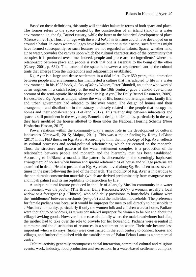
The interviews were conducted with residents of four villages that have bakuts: (i) Bakut
Pekan Lama (BPL) (see Figure 2); (ii) Bakut Pengiran Si Raja Muda (BPSRM), (iii) Kg.
Peramu (KP); and (iv) Kg. Saba Tengah (KST). The decision to focus on only four bakuts was
based on the availability of informants and data at the time. Table 1 provides details of the
informants for each of the four bakuts. The interviews were carried out in a semi-structured
manner to gather information on the following questions:
(a) How did the bakuts come about?
(b) What were the activities carried out at various times in the past?
(c) What is happening to the bakuts today? (issues / problems)
(d) Do you regard bakuts as part of Brunei’s heritage?
Figure 2. Panoramic view of Bakut Pekan Lama (BPL)

52 Noor Hasharina Hassan & Gabriel Y. V. Yong
Bakut Informant Informant’s Experience on Bakuts
Bakut Pekan Lama
(BPL)
PHH, 74, retired former
village head of BPL (same
person interviewed in the
Pelita Brunei article)
Village head of BPL and Pg Setia Negara
village (1993-2013) and acting penghulu (sub-
district head) of Mukim (sub-district) Burung
Pinggai until retiring in 2015; family worked
in boat-making industry in Subok with ties to
BPL.
Bakut Pengiran Si
Raja Muda
(BPSRM)
1) HS, 89 yr.,
grandmother
2) HR, 70+ yr.,
grandmother
3) HM, 74 yr.
grandmother
1) Lived on bakut for 18 yrs. (1929–1947)
before resettling on land.
2) Lives with children and grandchildren
since 1948.
3) Born in Temburong; lived in BPSRM
(1940s–1950s); moved to Peramu after
marriage, related to HR.
Kg. Saba Tengah
(KST)
1) HB, 68, resident
2) HY1, 67, resident
3) HJ, 66, resident
4) HY2, 62, resident
5) HZ1, 50, resident
1) Sold food on bakut as a child (1950–early
1960s).
2) Played games on bakut until teenage years
(1950s–1966).
3) Played on bakut until upper secondary
school age (1950s–1965).
4) Played on bakut until secondary school
age (late 1950s–1970).
5) Played on bakut till aged 12, (1970s–
1980), then used facilities on land.
Kg. Peramu (KP) 1) SM, 29, resident
2) HJM, 65, resident,
retired fisherman,
3) RM, 40, resident
4) FAY, 35, resident
5) HIN, 78, resident,
retiree
6) HKM, 62, resident,
former soldier
7) PMA, 42, resident
8) PHM, 74, former
resident
1) She has been on the bakut but does not use
it for any activity.
2) Originally from Kg Sultan Lama; moved
here in 1980s.
3) Sells food from her home on the bakut;
moved to KP when she got married.
4) Lives at KP, but works on land (with
Yayasan).
5) Lived in KP since birth; served as
penghulu (period unknown); his son is the
current penghulu (sub-district head); his
son also participated in the interview.
6) Lived in KP from 1962 to 1979.
7) Lived in KP until 1995.
8) Lived in KP (1962–1995), previously in
BPSRM (1950–1962); witnessed villagers
building raft on the bakut, an occupation
that led to the name of the village.
Table 1. Details about the informants in the four bakuts
The interviews were conducted and transcribed in Brunei Malay. The Malay spoken is not
standard Brunei Malay but conversational Malay used by the locals, and it is familiar to the
local Bruneian researchers. Where there are uncertainties, Brunei Malay dictionaries and other
sources, e.g. Internet and individuals knowledgeable in Brunei Malay, were consulted. The
data acquired were analysed to determine the cultural value of bakuts and their changes over
time vis-à-vis the development history of Brunei, as well as issues and problems concerning
their preservation. The main findings from the study shed light on (i) the origin and evolution
of bakuts in Kampong Ayer, (ii) their changing cultural values, and (iii) their potential heritage
values and issues concerning their conservation.

Bakuts in Kampung Ayer 53
Survey Results
The survey found that 79 of the 155 respondents (51.0%) did not know the word bakut. Of
those that said ‘yes’, only 36 of the 76 respondents (47.4%) correctly understood it as an island
in Kg. Ayer. Various descriptions given included: ‘piece of land’; ‘small hill in the river’;
‘piece of land in the midst of water’; ‘small land, muddy area in Kg. Ayer’; ‘flat and low
vegetated land’; and other descriptions (translated from Malay) that suggest an island feature.
There is a clear difference between those who have lived in Kg. Ayer (referred to as the Kg.
Ayer group) and those who have not (referred to as the Malay group): 74.2% of the Kg. Ayer
group who said they knew the word bakut described it correctly, while only 31.0% of the Malay
group who said ‘Yes’ got it correct.
When categorized according to age-group, in the Kg. Ayer group, a total of 23 people
correctly identified bakuts as island features: 4 out of 5 (80%) of the Elderly, 11 out of 14
(79%) of the Mature, 6 out of 8 (75%) of the Young, and 2 out of 4 (50%) of the Teens. In
addition, a total of 4 people knew bakuts only as part of village names: 1 out of 5 (20%) of the
Elderly, 2 out of 7 (14%) of the Mature, and 1 out of 8 (12.5%) of the Young. Although it is
not wrong to relate bakut to part of a village name in Kg. Ayer, the survey revealed that these
four respondents did not know what bakuts really are.
In the larger Malay group, a total of just 13 people correctly described bakuts: 2 out of 7
(29%) of the Elderly, 1 out of 9 (11%) of the Mature, 7 out of 19 (37%) of the Young, and 3
out of 7 (43%) of the Teens. In addition, a total of 15 people knew of bakuts only as part of the
name of a village: 3 out of 7 (43%) of the Elderly, 3 out of 9 (33%) of the Mature, 6 out of 19
(32%) of the Young, and 3 out of 7 (43%) of the Teens.
Several respondents (1 elderly Kg. Ayer resident and 4 Brunei Malays, of whom 1 was
Elderly, 1 Mature and 2 Young) thought that bakuts were ‘pile of stones’, ‘dykes’ or ‘sand
banks’ built (by tambak, embankments) to keep out water or to serve as a path through
wet/water areas. This could have been an extension of the usage of the word associated with
the construction of bakuts, but the meaning has changed for some people. Those who said they
know the word bakut but got it completely wrong described bakuts variously as kueh (a sweet
snack), a place in Malaysia (Membakut in Sarawak), cemetery tiles, a type of wood for making
furniture, and a barcode (maybe because it sounds like bakut).
As for functions of bakuts, 19 of the 23 of the Kg. Ayer group (83%) had something to say
regarding their use. Most of them said that bakuts were places for recreational activity, for ‘kids
to play’ and where traditional games, such as ridi (a traditional game played using a 10-cm
rattan with a sharp object attached at one end called the ridi), guli (marbles) and kites were
played. Some said that it is also a place to meet people, for communal gatherings, fishing or to
throw household waste. In contrast, only 3 out of 13 Brunei Malays (23%) said that bakuts are
recreation spaces (for fishing or playing), and another 2 thought they are used to prevent
flooding (an incorrect understanding of bakuts). The majority did not have any idea.
The survey found that the majority of the local Malay group do not know what bakuts are,
and very few of the minority that claim to know what it is actually know much about their use.
Although most Malays in the Brunei population can trace their roots to Kg. Ayer, it appears
that many have lost connections to Kg. Ayer, even though it is within easy reach from most
parts of the country. It is clear that only those who have lived in Kg. Ayer have some knowledge
of bakuts and its cultural value; but a few who have lived in Kg. Ayer or are still living there
are unaware of them. This is perhaps a reflection of the changing culture and reality brought
about by modernization and globalization.
54 Noor Hasharina Hassan & Gabriel Y. V. Yong
Interview Results
The interview data provided valuable insights into the origins, evolution and cultural value of
the bakuts. Each of these issues will be discussed in the following subsections.
Origins
According to an informant, BPL was constructed when Chinese traders from Singapore came
to Brunei (probably around late 19th or early 20th Century) and found the site, an island, ideal
but too small in size to establish a place of commerce. They negotiated with residents in the
area and, together, the locals and Chinese traders expanded this island over several years. The
process involved collecting rocks, logs and sand from a nearby area in Sg. Kianggeh (to which
Sg. Tekuyong is a tributary). They transported the material using tongkang (barges). This was
the best constructed bakut, as logs were used to secure the perimeter. As it was where Chinese
merchants sold their wares, it became known as Bakut Cina until it was renamed Bakut Pekan
Lama (Old Town Bakut). Based on a 1955 map by Hungting Aerosurvey, BPL was 2,690 m²
in size. Today, its size has decreased to around 1,900 m² and its centre has shifted 10 metres
southwards, away from the main channel.
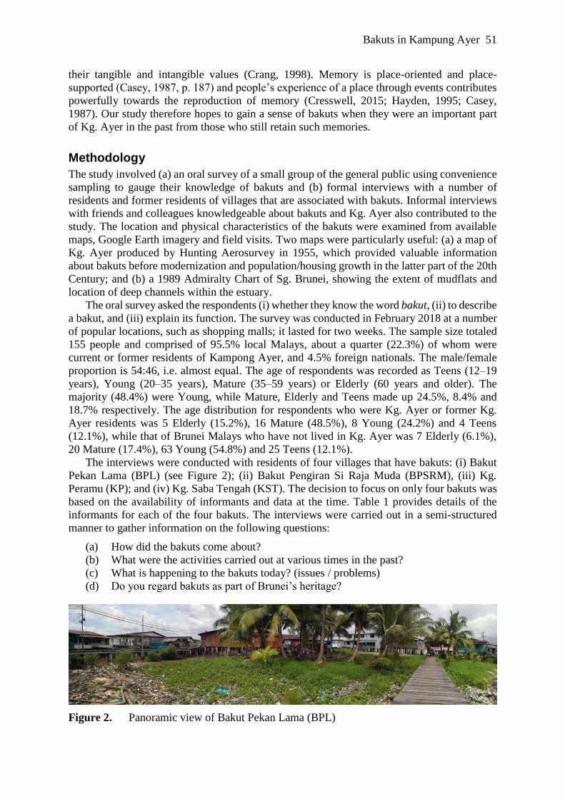
Figure 3. Bakuts and depositional features in Sg. Brunei Estuary at Kg. Ayer. Digitized
from a 1955 map by Hunting Aerosurvey (scale 1:5,000). The dotted lines mark
the edge of mudflats. Contours and present-day roads are shown for reference,
but houses are omitted so that the distribution of the islands can be clearly seen.
BPSRM is located about 70m east of BPL, with Bakut Berumput about 70m further to the
east (see Figure 3). Together with BPL, the three bakuts appear to be part of a set surrounded
by the homes of people of royal lineage. According the informants, BPSRM was considerably
larger in the past; 70 years ago, it was 2,100 m² in size, based on the 1955 map. Mangrove trees
used to fringe this sandy bakut, and fruit trees such as coconut, assam (tamarind) and ceramai
(Malay gooseberry) were grown there. Stilt houses were constructed around its edge. Today

Bakuts in Kampung Ayer 55
most of the bakut is submerged, so it is exposed only during low tide, and it is typically covered
with trash. The bakut in Kg. Bakut Berumput no longer exists, and residents of the village have
little recollection of what was a small bakut (390 m² in 1955). BPSRM and Berumput were
most likely constructed features, perhaps on existing sand bars, given that their names contain
the word bakut. They probably did not possess structures to protect them from erosion, because
tambak literally means piling up of materials, like sand, stones and pieces of wood, to raise the
ground.
In KST, the bakut is a large sandy island that is occasionally submerged during the highest
tides (see Figure 4). According to the informants, it was formed from a combination of: (a)
natural wave activity that transported sand to the island; and (b) the accumulation of waste
(mollusk shells, wood/bamboo shavings and household waste) discarded by the villagers. As
such, it may not be a true bakut, as the island formed naturally with human modification a by-
product of the life and activity of the villagers, and their contribution to its growth was mainly
by way of disposal of unwanted materials and not a deliberate construction. The bakut is most
likely a sand bar formed by sedimentation rather than wave activity; this is a common
depositional feature found along the edge of an estuary. Similar bakuts can be found to the east
and west of it, as though it was part of a set, as is characteristic of sand/mud bars in estuaries.
The KST bakut has a balai (community hall) built on stilts. It was 8,500 m² in size in 1955 and
is still about the same size (8,100 m²) today, but with its centre shifted 90m southwards away
from the main channel.
Figure 4. Panoramic view of Kg. Saba Tengah (KST). Note the young mangrove and
coconut trees growing on the bakut, as well as the trash accumulated
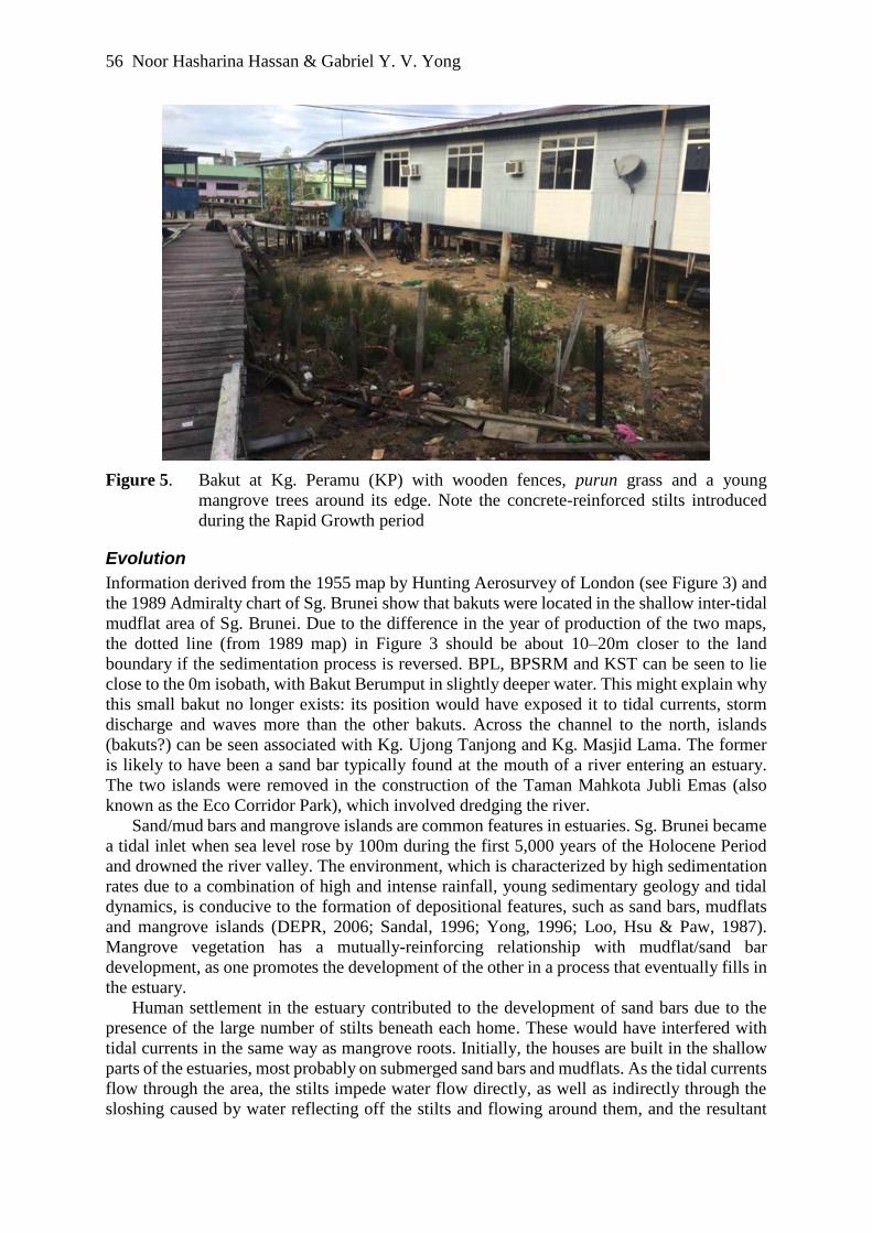
In Kg. Peramu (KP), mangrove vegetation such as purun (Lepironia), piai (mangrove fern)
and pidada (Sonneratia trees) are found on the sandy island (see Figure 5). A number of the
informants differentiated their island from other bakuts, referring to their patch of sand as a
tunjang, essentially a natural mangrove island. The villagers harvested the mangrove trees as
they were settling on the island, and they specialized in supplying mangrove poles for house
construction and in making rafts and other wood products. The bakut was large in 1955, with
an area of 12,980 m². However, its form is quite dynamic. According to one informant, the
central (higher) part of the tunjang has shifted below different houses over time. The island has
also shrunk in area considerably since 1955. In this study, tunjang is grouped together with
bakuts, as they share similar origin and development, i.e. natural features (sand bars or islands)
that were modified by human agency. The tunjang, like the bakut at KST, is largely natural; it
did not involve a stage of construction in its developmental history.
56 Noor Hasharina Hassan & Gabriel Y. V. Yong
Figure 5. Bakut at Kg. Peramu (KP) with wooden fences, purun grass and a young
mangrove trees around its edge. Note the concrete-reinforced stilts introduced
during the Rapid Growth period
Evolution
Information derived from the 1955 map by Hunting Aerosurvey of London (see Figure 3) and
the 1989 Admiralty chart of Sg. Brunei show that bakuts were located in the shallow inter-tidal
mudflat area of Sg. Brunei. Due to the difference in the year of production of the two maps,
the dotted line (from 1989 map) in Figure 3 should be about 10–20m closer to the land
boundary if the sedimentation process is reversed. BPL, BPSRM and KST can be seen to lie
close to the 0m isobath, with Bakut Berumput in slightly deeper water. This might explain why
this small bakut no longer exists: its position would have exposed it to tidal currents, storm
discharge and waves more than the other bakuts. Across the channel to the north, islands
(bakuts?) can be seen associated with Kg. Ujong Tanjong and Kg. Masjid Lama. The former
is likely to have been a sand bar typically found at the mouth of a river entering an estuary.
The two islands were removed in the construction of the Taman Mahkota Jubli Emas (also
known as the Eco Corridor Park), which involved dredging the river.
Sand/mud bars and mangrove islands are common features in estuaries. Sg. Brunei became
a tidal inlet when sea level rose by 100m during the first 5,000 years of the Holocene Period
and drowned the river valley. The environment, which is characterized by high sedimentation
rates due to a combination of high and intense rainfall, young sedimentary geology and tidal
dynamics, is conducive to the formation of depositional features, such as sand bars, mudflats
and mangrove islands (DEPR, 2006; Sandal, 1996; Yong, 1996; Loo, Hsu & Paw, 1987).
Mangrove vegetation has a mutually-reinforcing relationship with mudflat/sand bar
development, as one promotes the development of the other in a process that eventually fills in
the estuary.
Human settlement in the estuary contributed to the development of sand bars due to the
presence of the large number of stilts beneath each home. These would have interfered with
tidal currents in the same way as mangrove roots. Initially, the houses are built in the shallow
parts of the estuaries, most probably on submerged sand bars and mudflats. As the tidal currents
flow through the area, the stilts impede water flow directly, as well as indirectly through the
sloshing caused by water reflecting off the stilts and flowing around them, and the resultant

Bakuts in Kampung Ayer 57
drop in flow speed induces sedimentation. However, the development of villages on and along
the edge of bakuts, such as at KP, would have involved removal of mangrove trees. This will
have left the land exposed and unprotected from tidal currents that can reach speeds capable of
eroding sand banks. Bakuts that do not have stabilization structures are therefore prone to
erosion from tidal processes.
Cultural Value
The cultural value of bakuts refers to their importance to the people and their daily activities.
The study found that this value has changed through time and varies with the different bakuts.
For the purpose of evaluation, the level of importance is ranked (from lowest to highest) in
relation to the importance of the bakuts to:
(1) individuals carrying out various personal or group activities;
(2) groups carrying out activities that serve the community, including industry and farming;
and
(3) activities that support life in the area and beyond.
The level of activity, in terms of frequency of use and number of people involved, also
reflects the importance and, therefore, cultural value of the bakuts. The distribution of
inhabitants is considered in the evaluation, as the majority of the country’s population was
concentrated in Kg. Ayer during the first half of the 20th Century but later dispersed across the
land after 1970s. This has implications for the connection between the people, places and the
meanings attached. The transition from Kg. Ayer to land in the development of Brunei also
affected use and importance of bakuts because alternative, better facilities and spaces became
available to serve cultural needs.
The analytical timeframe is divided into five distinct periods of Brunei’s history from the
beginning of the 20th Century:
(1) British Administration (1906–1959) refers to a period when Brunei was administered by
a British resident from 1906 to 1942 and a second period following the Second World
War until 1959 without a Resident; this includes the period under Japanese occupation
(1942–1945).
(2) Modernization (1960–1978) is the period of steady modern development and growth
guided by national develop plans made possible by revenue from oil and gas resources.
(3) Rapid Growth (1979–1986) is a period of development fueled by a high oil price. The
population of Kg. Ayer peaked as modern infrastructure was built in the settlement.
However, this also resulted in over-crowding, pollution and a number of serious fires.
(4) Sustainability Concerns (1987–2002) is the period when the nation had to face the fall-
out of rapid development and a sharp fall in oil price (hence, revenue). It was also a
period of emerging awareness of sustainability issues and regional/global adoption of
sustainable development agendas.
(5) 21st Century Growth (2003–present) is the current period which began with rising/high
oil price and new optimism in an age of globalization and connectivity via information-
communication technology (ICT).
Given Brunei’s reliance on its hydrocarbon resources since the discovery of oil in 1929,
the country’s development and growth has inevitably been connected to the rise and fall of oil
prices. An interesting factor to note is the population in Kg. Ayer, which increased from 8,000
in 1950 to a peak of 27,000 in the 1980s despite resettlement programs initiated by the British
Resident in 1906 that later developed into a national housing program (Noor Hasharina Hassan
& Yong, 2019). The population of Kg. Ayer has since declined to the current level of around
13,000 people.

58 Noor Hasharina Hassan & Gabriel Y. V. Yong
Table 2 provides a summary of cultural activities on the four bakuts synthesized from data
derived from the informants.
Period BPL BPSRM KST KP
British
Administration
The only
commercial site in
Kg. Ayer that sold
imported wares;
duck farming;
weddings,
traditional games,
sports and
recreation.
Not much
information
available;
fruit trees
grown; games
played;
valuables
buried in jars
in the bakut.
No clear data;
activities included
food processing,
boat/fish trap
making, community
gathering like in the
1950s–60s were
probably practiced.
Mangrove pole
harvesting (meramu
kayu) was the main
activity; other cottage
industries included
boat and raft building
and bamboo
products; barter
trading.
Modernization Duck farming;
traditional games;
weddings;
religious
gathering;
commercial
activity shifted to
Brunei Town on
the north bank of
Sg. Brunei.
Sports and
games.
Food sold and
religious gatherings
were held at balai;
Products made: fish
traps (kilong,
lintau), kapur
(lime); chicken
reared; children
played traditional
games like tarik
kalat (tug of war),
tinting (hopscotch),
gasing (top), goli
(marble); cock
fighting was
popular.
Cottage industry
declining; bakut
mainly used for
leisure/recreation, as
it provided a sandy
beach-like
environment for
children to play in the
sand and shallow
water. The main use
of the bakut is
providing land for
building houses.
Rapid Growth Some leisure
activities.
Trash
accumulation;
bakut eroded.
7–8 fire outbreaks;
bakuts not used.
Bakut fenced,
wooden platform
built to facilitate
recreation activities,
mainly for children;
sand used in making
cement – for shoring
up house stilts.
Sustainability
Concerns
A fire event
further detered use
of bakuts.
Bakut
eroding;
accumulating
trash.
Not used, as bakut
is kamah (dirty,
polluted,
hazardous).
Bakut became very
polluted (trash) since
early 1990s. Jelly fish
common in water.
21st Century
Growth
Some leisure
activities; fence
built to manage
trash entering
bakut with the
tides.
Bakut
eroding;
accumulating
trash.
Part of bakut
dredged for
navigation (2011);
polluted.
Largely a dumping
ground; older
children still play on
bakut, esp. during
holidays because
‘there is no other
place’; crocodiles
frequently seen on /
around the bakut.
Table 2. Cultural activities on bakuts since the early 20th century
Bakuts in Kampung Ayer 59
The research found that during the British Administration period, PBL was an important
cultural center, as it was the first and only center of commerce, where residents of Kg. Ayer
could acquire modern household wares and materials. It provided the villagers residing around
the bakut land space to carry out a range of activities individually and as a community. It also
gave them an identity and a sense of belonging to this particular place; residents here are of
royal lineage and PBL is where one could get imported items. It could be argued that PBL had
high cultural value, given its importance during the first half of the 20th Century. However, its
value began to decline with the shift of commercial activities to Brunei Town, which developed
on the north bank of Sg. Brunei later during this period. The bakut was, however, still used for
communal events, such as weddings and religious gatherings, and for sports and games. Many
residents reared ducks. Its use became more confined to the life and needs of the local
community than the people of Kg. Ayer. The bakut provided residents, especially the young,
land space for leisure and recreation activities. Traditional games such as ridi were played, and
later, more modern games such as badminton, raga (takraw) and soccer.
However, by the 1970’s, the bakuts became less used as modernization provided residents
with better facilities on land. Many have also found employment on land, where the jobs and
development are concentrated, so the villagers’ cultural activities inevitably shifted to land.
Bakuts then became simply pieces of land near to the homes of the villagers. As such, there
were few activities on the bakuts and they tended to be personal rather than communal.
Moreover, BPL, together with its sister bakuts, BPSRM and Berumput, suffered from erosion,
causing them to deteriorate and decrease in size. BPL, better constructed for its purpose as a
commercial center, withstood erosion better than BPSRM and Berumput. The bakut at Kg.
Bakut Berumput has now disappeared completely.
During the period of Rapid Growth, trash pollution emerged as an unwelcomed feature. It
was worst at BPSRM as the bakut had eroded to become a submerged bar, which enhanced its
capacity to draw in floatable trash during ebb tides. The Department of Environmental, Parks
and Recreation has installed a fence around BPL to trap trash as part of its effort to manage the
waste pollution. By then, the cultural value of BPL had declined substantially, and only a few
individuals still use it for leisure and recreation activities.
At KST and KP, the bakuts were large natural islands (sand bars) which were modified as
a consequence of villagers settling in the area. The bakuts provided space for cultural activities,
from industry to communal events and leisure activities by individuals and families. However,
they also served as dump sites for household and production waste, which, according to the
informants, built up the bakut over the years together with natural processes. Chicken were
kept on the bakuts and cock fighting was a popular pastime. Given their natural make-up,
bakuts are responsive to the hydrodynamics in the estuary, especially with their protective
mangroves removed; they are therefore quite dynamic. This is particularly the case at KP where
harvesting mangrove trees to produce poles for house and raft construction became the main
industry of the village. However, the period of Modernization similarly shifted a large part of
the activities of the villages to land, as more people were resettled there. As with the other
bakuts, the cultural value declined from its high point during the British Administration period
to a moderate level during the early period of Modernization when activity on the bakuts
slowed down somewhat.
The shift in employment opportunities, changes in culture and needs brought about by
modernization and increased wealth, as well as better facilities on land resulted in the
abandonment of bakuts as cultural spaces. Instead, they became dumping ground and sites of
trash accumulation, as the type of waste being discarded changed from small, organic items to
larger, non-biodegradable things. This in turn made the bakuts less conducive for family leisure
activities, further eroding their cultural value. Today, the bakuts have decreased considerably

60 Noor Hasharina Hassan & Gabriel Y. V. Yong
in size. At the same time, they have been recolonized by wildlife, and estuarine crocodiles and
otters are commonly found on the bakuts.
Discussion: Heritage and Conservation
Bakuts provide the inhabitants of Kg. Ayer with land spaces – terra firma upon which to carry
out life activities in a water environment (estuary); one informant said it simply: because there
is ‘no other place’, no padang (fields), for children to play in, or to hold communal events. The
same informant revealed that some of her own children had preferred to stay in the village
rather than go and live with relatives on land during vacations because they found life in the
village and bakut freer and not as monotonous and boring. The same sentiments were echoed
by most of the informants, describing life on bakuts as more ‘fun’ when they reminisced.
People and places (bakuts) are co-ingredients in place-making, which is why there is a strong
bond between them (Casey, 2001, p. 684). Although the majority of Brunei’s citizens have
ancestry in Kg. Ayer, most are somewhat ignorant about bakuts, which hold no meaning or
value to them. However, bakuts are clearly deeply embedded in the psyche (memory) of those
who experienced life on them. Each has their distinctive features, stories, products, lineage and
therefore, identity, which was created by, and therefore represents, the clan that lived on and
around them. They were important features during a specific period of the nation’s history and
culture, and therefore a part of Brunei’s heritage.
Culture is a prime determinant in the creation of place. The distribution and location of
houses in Kg. Ayer are cultural imprints of people and their social interaction with each other
and also their relation with the Sultan (LeBlanc, 2017; Noor Hasharina Hassan & Yong, 2019).
However, our findings suggest that the physical environment plays an equally significant role
in the pattern and morphology of Kg Ayer. The bakuts in Kg. Ayer are not simply features
found in the water village complex. On the contrary, they influenced the distribution of villages
in the settlement. As one informant stressed, land is essential for erecting stilt houses. The
villages at Kg. Ayer were thus founded on submerged or intertidal sand bars, some of which
were modified into bakuts deliberately (e.g. at BPL) or as a consequence of cultural needs and
processes (e.g. KP and KST). Over time, they became landmarks and representative of the
territories of the different clans in Kg. Ayer; their size, appearance and activities reflect the
clans’ power and identity (Casey, 2001). In Kg. Ayer, bakuts are pivotal in the development of
the cultural landscape (see Cresswell, 2015; Malpas, 2011) that have emerged due to people
settling at locations because of their characteristics and how the relationship between cultural
activity and environment shape the characteristics of the surrounding environment over time.
We argue that the cultural value of bakuts in the past and their role in the development of
Kg. Ayer and its morphology justify their consideration as part of Brunei’s heritage that ought
to be preserved for posterity before they suffer further deterioration or are lost forever. This
could be done through preservation work that protects them from degradation (e.g. due to
erosion and pollution) and conservation programs to elucidate their cultural value in the past,
maybe by establishing commemorative spaces and organizing cultural or touristic events. Such
events and meaningful features on a bakut would produce ‘places of commemoration’ (Crang,
1998), where people can learn about its intangible and tangible values. However, before such
efforts are taken, it is vital to appreciate the genius loci or the spirit of the place through the
people and their memory (Cresswell, 2015; Jackson, 1994; Norberg-Schulz, 2000).
It is hoped that the research findings presented can catalyze conservation efforts as well as
more research interest, to allow the current generation to have a glimpse of their cultural
heritage. A well-designed monument or events could potentially make the past come to life in
the minds of visitors. Memory is ‘place-oriented’ and ‘place-supported’ (Casey, 1987, p. 187)
and people’s experience of a place through events contributes powerfully towards the

Bakuts in Kampung Ayer 61
(re)production of memory (Cresswell, 2015; Hayden, 1995; Casey, 1987), such as those shared
by informants in this study.
There are however three main challenges to the preservation of bakuts and the conservation
of their cultural values:
(1) Ignorance. The majority of the population has now lived on land for more than two
generations and has lost their connection with Kg. Ayer, apart from knowing the place as
the cultural heart of Brunei. The study found that the majority of local Malays, particularly
the younger generation, have little or no knowledge of bakuts, and therefore no sense of
belonging towards bakuts or awareness of them as cultural heritage. As such, it will be a
challenge to generate enough interest or support for any preservation or conservation
efforts for bakuts in Kg. Ayer.
(2) Erosion. Apart from BPL, bakuts are not constructed according to modern engineering
standards to ensure that they last. Tambak is literally piling up of materials (sand, clay,
rocks, coconut shells, etc.) to raise the level of the ground. They are therefore prone to
erosion in areas that are exposed to tidal and storm discharge currents or to waves
generated by the large number of water taxis that traverse the area each day. Tunjangs and
other largely natural bakuts are dynamic features that will continue to evolve with natural
and cultural processes. As they become less used and irrelevant to the villagers, they have
diminished in size as tidal currents have eroded and redistributed the sediments. Any effort
to preserve bakuts must address erosion processes that occur with the ebb and flow of the
tides.
(3) Pollution. In estuarine environments, sand bars are magnets for trash, drawing in floatable
debris in the vicinity. While household waste discarded by villagers once contributed to
the building up of bakuts, modern waste comprising a large quantity of plastic and other
non-biodegradable composite materials give rise to trash pollution. Managing trash in Kg.
Ayer has been a priority and major challenge for the environmental agency (DEPR, 2006).
Conclusion
The bakuts associated with villages with the word bakut in their name, such as Bakut Pekan
Lama, where the bakut still exists, were likely to have involved deliberate construction in their
development. In general, bakuts were built on natural depositional features in the Sg. Brunei
estuary, such as sand bars, inter-tidal mudflats and existing islands. They therefore influenced
the distribution pattern of houses and villages in Kg. Ayer, and hence its overall morphology.
It is evident from our research that bakuts served important cultural functions in the past. They
provided land space in a water environment that supported a variety of cultural activities.
Although they remain part of the landscape of Kg. Ayer, they are now inconspicuous, and hold
little or no cultural value for the majority of the nation’s citizens. However, they once had
influence over the social, economic and political dynamics of Kg. Ayer before their importance
diminished with modernization, particularly since the 1970s. The society today is largely
ignorant of bakuts, and their cultural values exist only in the memory of those who experienced
life on them, and in historical accounts of Kg. Ayer. Presently, most of the bakuts are at an
advanced stage of deterioration, and a number have disappeared entirely. Bakut Pekan Lama,
the first town in Brunei, is the only one in relatively good condition. Given their importance in
the history, culture and evolution of Kg. Ayer, and therefore Brunei, it is important to preserve
some of the bakuts that are being eroded and conserve their cultural values through, for
example, developing them into places of commemoration, rituals and special visits. Such effort
could provide visitors with a glimpse of the life and culture from a time long forgotten. For
Bruneians, it could stimulate a sense of place, wonder, pride and connection with their
62 Noor Hasharina Hassan & Gabriel Y. V. Yong
ancestors and heritage. Challenges include generating interest and awareness among the
population, protecting bakuts from erosion, and managing pollution from trash on them.
Acknowledgments
The authors would like to acknowledge UBD for funds that made it possible to present this
study at the Borneo Research Council conference in Kuching, 6–8 August 2018. We would
also like to acknowledge the contribution of our students, who helped in the collection of data
for this study: Alita Selamuda, Liyana Taib, Muhammad Firdaus Haji Ismail, Nur Amanina
Syairah Haji Hasnani, Nur Izzati Haji Zainal Ariffin, Nurul Aqilah Othman, Nurul Bazilah
Untong, Nurul Hazirah Haji Zainuddin, Rabiatul Zahidah Tahamat/Moksin and Shahbudi
Waqiyuddin Wasli.
References
Anderson, J. (2015). Understanding cultural geography: Places and traces. New York, NY:
Routledge.
Casey, E. (1987). Remembering: A phenomenological study. Bloomington, IN: Indiana
University Press.
Casey, E. (2001). Between geography and philosophy: What does it mean to be in the place-
world? Annals of the Association of American Geographers, 91(4), 683–693.
Crang, M. (1998). Cultural geography. London: Routledge.
Cresswell, T. (2015). Place: An introduction. Oxford: Wiley Blackwell.
DEPR (Department of Environment, Parks & Recreation) (2006). Brunei Darussalam first
state of the environment report. Bandar Seri Begawan: Ministry of Development,
Government of Brunei Darussalam.
Dk. Hajah Fatimah Pg. Haji Md. Noor. (2009). Kampung Pekan Lama: ‘Pusat komersial
pertama Brunei’. Pelita Brunei, 21 October 2009.
Hayden, D. (1995). The power of place: Urban landscapes as public history. Cambridge,
MA: MIT Press.
Jackson, J. B. (1994). A sense of place, a sense of time. New Haven, CT: Yale University
Press.
DBP. (2010). Kamus Bahasa Melayu Brunei (2nd. ed.). Bandar Seri Begawan: Dewan
Bahasa dan Pustaka.
LeBlanc, R. (2017). A deleuze theory of urban morphology: Brunei Water City (unpublished
PhD thesis). Victoria University, Wellington.
Loo, M., Hsu, L., & Paw, J. (1987). Physical environment. In T-E. Chua, L. M. Chou, &
M.S.M. Sadorra (Eds.). The coastal environmental profile of Brunei Darussalam:
Resource assessment and management issues (pp. 5–27). BSB: Department of Fisheries,
Brunei Darussalam & Manila: ICLARM (International Center for Living Aquatic
Resources Management).
Malpas, J. (Ed.). (2011). The place of landscape: Concepts, contexts, studies. Cambridge,
MA: MIT Press.
Noor Hasharina Hassan. (2017). Housing matters: The value of home ownership in Brunei
Darussalam. Institute of Asian Studies Working Paper No. 36, Universiti Brunei
Darussalam.
Noor Hasharina Hassan, & Yong, G. Y. V. (2019). A vision where every family has basic
shelter. In R. Holzhacker & D. Agussalim (Eds.), Sustainable development goals in
Southeast Asia and ASEAN: National and regional approaches (pp. 190–209). Singapore:
Brill.
Norberg-Schulz, C. (2000). Architecture: Presence, language, and place. Milan: Skira

Bakuts in Kampung Ayer 63
Pethick, J. (1995). An introduction to coastal geomorphology. Chichester, UK: Wiley.
Sandal, T. S. (Ed.) (1996). The geology and hydrocarbon resources of Negara Brunei
Darussalam. Bandar Seri Begawan: Brunei Shell Petroleum and Muzium Brunei.
The Daily Brunei Resources (2007, 7 March). Padians of Brunei’s kampong Ayer. Retrieved
from <http://bruneiresources.blogspot.com/2007/03/padians-of-bruneis-kampung-
ayer.html>.
The Daily Brunei Resources (2009, 19 April). A city of many waters. Retrieved from
<http://bruneiresources.blogspot.com/2009/04/city-of-many-waters.html>.
Yong, G. Y. V. (1996) Coastal geomorphology in Brunei Darussalam. In K. U. Sirinanda &
P. Michael (Eds.), Geography at Universiti Brunei Darussalam: The first decade (pp. 53–
80). Gadong: University Brunei Darussalam.