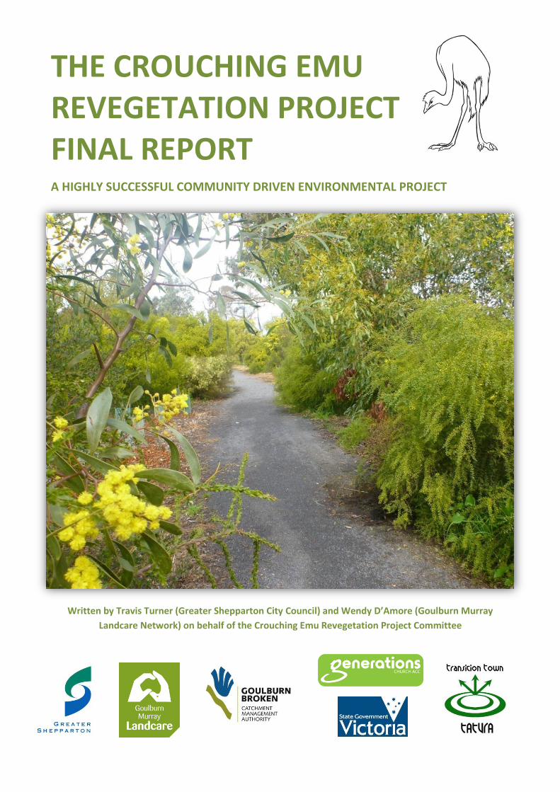
The Crouching Emu revegetation project FINAL REPORT
68
Written by Travis Turner (Greater Shepparton City Council) and Wendy D’Amore (Goulburn Murray Landcare Network) on behalf of the Crouching Emu Revegetation Project Committee d THE CROUCHING EMU REVEGETATION PROJECT FINAL REPORT A HIGHLY SUCCESSFUL COMMUNITY DRIVEN ENVIRONMENTAL PROJECT
Transcript of The Crouching Emu revegetation project FINAL REPORT
Written by Travis Turner (Greater Shepparton City Council) and Wendy D’Amore (Goulburn Murray
Landcare Network) on behalf of the Crouching Emu Revegetation Project Committee
d
THE CROUCHING EMU REVEGETATION PROJECT FINAL REPORT A HIGHLY SUCCESSFUL COMMUNITY DRIVEN ENVIRONMENTAL PROJECT
2
Acknowledgements
The Crouching Emu Revegetation Project Committee would like to take this opportunity to thank
and acknowledge the following people and organisations, both past and present who contributed
an enormous amount of time and effort to ensure the success of the Crouching Emu Revegetation
Project.
The following community Committee members oversaw the realisation of the project from start to
finish: the Goulburn Murray Landcare Network and the Dhurringile and District Landcare group
members John Laing and Wendy D’Amore; Terry Court and the Tatura Revitalisation Committee
(the Tatura Revitalisation Committee was instrumental in starting the project); Ron Mallon,
Minister at the Generations Church ACC, Tatura. Transition Towns Tatura (Ross Musolino in
particular) also sat on the Committee and contributed to the outcomes of the project over the final
few years. This knowledgeable, committed, passionate group of people voluntarily donated a great
amount of their time to improve their local environment and community.
The following organisations had several Committee members involved along the journey. The
Greater Shepparton City Council project managers were Sustainability and Environment Officers
Tracy Taylor, Marisa O’Halloran, Ann Roberts and Travis Turner with support from their manager,
Greg McKenzie (Manager, Environment). Department of Primary Industries Officers Gemma Beard,
Chelsea Nicholson, Nickee Freeman and Jen Pagon, were also important contributors.
Students and teachers from all three Tatura Primary Schools (Tatura Primary School, Sacred Heart
School, Bethel Christian College) and Mooroopna Secondary College, along with Dhurringile Road
residents and the wider Tatura community are thanked for their involvement in annual National TD
plantings, watering and site maintenance. Joe Masters and the Mission Australia National Green
Jobs Corps youth work crew (formerly the GV REEP work crew) also provided countless hours of
labour at no charge.
The Goulburn Broken Catchment Management Authority (GB CMA) contributed financial support
via several community education and awareness grants. Thanks in particular to Chris Norman
(CEO), Tony Kubiel and Rachael Spokes for their support. The Tatura Guardian and Tatura Area
Community Bulletin provided continuous publicity to raise the community’s awareness of project
activities.
The committee would finally like to thank Don Roberts from BirdLife Australia, Michael Lea-Whyte,
Craig Tuhan, Phil Hunter, Graham Donaldson and Bernie Hughes for their ongoing involvement and
contribution to the project’s successes.
3
Contents
1 Executive Summary ........................................................................................................................ 5
2 Introduction ................................................................................................................................... 6
2.1 Project mission ........................................................................................................................ 6
2.2 Project vision ........................................................................................................................... 6
2.3 Project objectives .................................................................................................................... 6
2.4 Project management and budget ........................................................................................... 6
2.4.1 The Crouching Emu Revegetation Project Committee .................................................... 7
2.4.2 Other key project contributors ........................................................................................ 7
2.5 Final Project Report 2013 rationale ........................................................................................ 7
3 Landscape history and pre-project native vegetation present ..................................................... 9
4 Project reporting .......................................................................................................................... 10
4.1 Vegetation survey of Dhurringile Road (Midland Hwy to Sewerage Farm) 2006 ................. 10
4.2 Mid-project Assessment Report 2006 - 2009 ....................................................................... 10
4.3 Crouching Emu Revegetation Project Strategic Plan 2011-2015 .......................................... 10
5 Site selection and revegetation process ...................................................................................... 11
6 Measuring our ecological outcomes (site assessments) ............................................................. 13
6.1 Ecological assessment methodology .................................................................................... 13
6.2 Bird survey methods ............................................................................................................. 16
6.3 Ecological assessment results - Individual site assessments ................................................ 17
6.4 Bird survey results ................................................................................................................. 29
7 Meeting our Ecological objectives ............................................................................................... 30
7.1 Establish an environmental corridor, primarily containing indigenous species ................... 30
7.2 Increase the conservation value of the vegetation communities along Dhurringile Road .. 31
7.3 Conserve areas less affected by disturbance and containing significant indigenous plant
species .............................................................................................................................................. 33
8 Achieving our community awareness and education objectives ................................................ 35
8.1 Significant community awareness and engagement activities ............................................. 35
8.2 Accessing our success at achieving our community awareness and engagement activities 39
8.2.1 Community survey summary 2012 ................................................................................ 39
8.2.2 School survey summary 2012 ........................................................................................ 40
8.3 Meeting our Community awareness and engagement objectives ....................................... 41
4
8.3.1 Enhance the town entrance and provide pedestrian and bicycle access...................... 41
8.3.2 Increased community awareness and education, especially in regard to indigenous
plants and weed management .................................................................................................... 42
9 Key project learning’s .................................................................................................................. 43
9.1 Revegetation activities .......................................................................................................... 43
9.2 Community engagement ....................................................................................................... 43
10 Management recommendations ................................................................................................. 45
10.1 Site management recommendations ................................................................................ 45
10.1.1 Weed management ....................................................................................................... 45
10.1.2 Removal of tree guards .................................................................................................. 45
10.1.3 Watering ........................................................................................................................ 45
10.1.4 Pruning and removal of dead plants within town boundary ......................................... 45
10.1.5 Access drainage .............................................................................................................. 45
10.1.6 Walking path safety concerns at road and train crossings ............................................ 46
10.1.7 Significant site management ......................................................................................... 46
10.2 Recommendations for future activities ............................................................................. 46
11 In closing ...................................................................................................................................... 47
Appendix I – Crouching Emu Roadside Assessment Sheet .................................................................. 48
Appendix II – Native species present during Dhurringile Rd revegetation site assessments (February
2012) .................................................................................................................................................... 52
Appendix III – Weed species present during Dhurringile Rd revegetation site assessments (February
2012) .................................................................................................................................................... 54
Appendix IV – Fauna recorded during Roadside survey (8 March) and on three adjacent properties
(31 August). .......................................................................................................................................... 56
Appendix V - Summary of Crouching Emu site assessment scoring 2012 ........................................... 57
Appendix VI – Site maps for each individual revegetation site ........................................................... 58
Appendix VII - Front page Tatura Guardian article about the Project’s community walk .................. 63
Appendix VIII – 2012 Crouching Emu Revegetation Project brochure ................................................ 64
Appendix IX – 2012 Community Survey ............................................................................................... 66
Appendix X – 2012 School Survey ........................................................................................................ 68
5
1 Executive Summary
The Crouching Emu Revegetation Project (the Project) was a Tatura community driven project that
commenced in 2006 and concluded at the end of 2012. The Project’s mission was to establish an
environmental corridor containing indigenous species along Dhurringile Road, Tatura. Key components of
the Project were to protect and enhance the remnant native vegetation present along Dhurringile Road
through extensive revegetation activities and a community engagement process to increase environmental
awareness.
This Final Project Report has been written to outline the Project’s original objectives and explore how
successful the project has been at achieving them.
By the end of 2012 the Crouching Emu Revegetation Project had accomplished the following major
achievements:
The density and diversity of native species has been greatly increased with over 13,000 indigenous
plants planted over the last seven years.
Approximately 8km of environmental corridor containing indigenous vegetation will have been
established linking the pre-project patches of remnant native vegetation.
Weed species are greatly reduced in numbers and woody weeds such as willow and peppercorn are
now largely absent from the roadside.
Walking paths have been constructed through the planted vegetation to encourage pedestrian and
bicycle use and will allow for increased accessibility and appreciation of these enhanced areas.
Aesthetics of town entrances have been greatly enhanced.
The Project was nominated for two Tidy Towns Sustainable Communities 2011 Awards (State finalist in
the Community-Government Partnership category).
The substantial achievements of the Crouching Emu Revegetation Project are proof that the community can
make extensive improvements to their local environment over very short time periods. The key to achieving
these successes has been a strong emphasis on community engagement and establishing strong
partnerships between state and local government, community groups and the community themselves. Other
important components of the Project were monitoring the success of revegetation activities across the sites
and evaluating the community’s awareness of the Project over time.
Now that the Project is complete and the committee disbanded, it is time to hand over the management of
the revegetated roadside areas from the Crouching Emu Revegetation Project Committee (the Committee)
to Greater Shepparton City Council’s Landscaping and Native Open Space Team.
This document contains management activities and recommendations to guide the management of the
revegetated sites into the future. It is hoped that the contents of this report will assist other
environmental/community projects to achieve similar successes.
6
2 Introduction
The Crouching Emu Revegetation Project was officially launched on 6 December 2006 by Greater Shepparton
City Councillor Bruce Wilson and concluded at the end of 2012. The overarching aim of the project was to
establish an environmental corridor, primarily containing indigenous species along Dhurringile Road, Tatura,
between the Midland Highway and Toolamba/Rushworth Road. This corridor would link existing and
potential environmental features through revegetation activities involving the local Tatura community.
In January 2006, a comprehensive vegetation survey of Dhurringile Road was conducted to determine the
flora species present and assess the quality of the vegetation communities within the project area. The
survey concluded that although large proportions of the roadside was highly disturbed, the vegetation
communities and significant indigenous species were present which required considerable conservation
priority.
2.1 Project mission
The mission of the Crouching Emu Revegetation Project was to establish an environmental corridor that
primarily contains indigenous species along Dhurringile Road, Tatura, between the Midland Highway and
Toolamba-Rushworth Road.
2.2 Project vision
The vision of the Crouching Emu Revegetation Project was to establish the environmental corridor by
protecting the native vegetation present and enhancing it through extensive revegetation activities.
Community engagement and increased environmental awareness are key components to the project and
community participation is recognised as vital to the success of the revegetation and environmental
enhancement activities.
2.3 Project objectives
The following key strategic objectives were outlined to achieve the project’s mission:
Establish an environmental corridor, primarily containing indigenous species.
Increase the conservation value of the vegetation communities along Dhurringile Rd.
Conserve areas less affected by disturbance and containing significant indigenous plant species.
Significantly reduce pest plants through weed management coordinated in collaboration with adjacent
landowners.
Enhance town entrances and encourage pedestrian and bicycle access.
Increase community awareness and education, especially in regard to indigenous plants and weed
management.
2.4 Project management and budget
Greater Shepparton City Council has supported the project for the past seven financial years by both
financial and in-kind support. Council’s financial contribution was an annual budget allocation of $12,000
from 2006 to 2010 then $6,000 in 2011/12 and $6,300 2012/13. This funding has paid for site preparation
activities, weed control, plants, planting and planting equipment, plant watering, buses to transfer school
children for planting days and publicity brochures. Council also made in-kind contributions via their
Sustainability and Environment Officer in allocated time to co-ordinate the Project. The Goulburn Murray
Landcare Network and Department of Primary Industries contributed project coordination through the Local
Area Plan facilitator and coordinator positions until 2011. This was then continued by a Goulburn Murray

7
Landcare Network Project Officer. The Goulburn Broken Catchment Management Authority (GBCMA) also
contributed almost $8,000 towards the projects activities via three Small Community Education and
Awareness Grants.
2.4.1 The Crouching Emu Revegetation Project Committee
The Project’s major stakeholders formed the Crouching Emu Revegetation Project Committee to ensure that
all the projects objectives were achieved. Throughout the life of the Project the Committee contained
representatives from:
Greater Shepparton City Council
Goulburn Murray Landcare Network (GMLN)
Dhurringile and District Local Area Plan/ Dhurringile and District Landcare Group
The Department of Primary Industries (DPI)
Tatura Revitalisation Committee
Generations Church ACC, Tatura
Transition Tatura.
For the past seven years members of the Crouching Emu Revegetation Project Committee (and the
organisations and groups they represent) have contributed to the Project via project management, site
management, planting and site maintenance, coordination of school and community planting days, and
other school and community education activities.
2.4.2 Other key project contributors
Along with the Dhurringile Road residents and Tatura community, the following schools and groups have
made significant contributions to the outcomes of the project:
Tatura Primary School
Sacred Heart School
Bethel Christian College
Mooroopna Secondary College
Tatura Girl Guides
Mooroopna Girl Guides and Scouts
The successes of the Project would not have been possible without the hard work and commitment from the
Mission Australia National Green Jobs Corps work crew (formerly known as the Goulburn Valley Regional
Environment Employment Program (GVREEP)), who provided countless hours of labour at no charge. The
Goulburn Broken Catchment Management Authority (GBCMA) also provided financial support to the Project
via several community education and awareness grants. The Tatura Guardian and Tatura Area Community
Bulletin have provided wonderful support by publishing articles on the Project activities.
2.5 Final Project Report 2013 rationale
The purpose of this final report is to provide an overview of the projects major accomplishments, evaluate
project successes, outline key project learning’s and make recommendations for the future management of
the Dhurringile Road roadside. This document contains management activities and recommendations to
guide management of the revegetated sites into the future. It is hoped that the contents of this report will
also assist other environmental/community projects to achieve similar successes.
This report is also a companion document for the official Council Handover Report for the management of
the revegetated roadside areas. From 2014, Greater Shepparton City Council’s Landscaping and Native Open
8
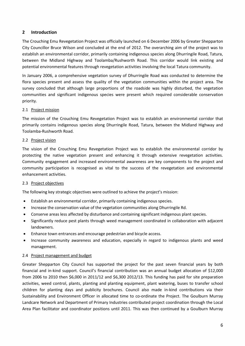
Space Team is responsible for maintaining the revegetated areas between Pyke Road and Murton Road.
Figure 1 (below) was sourced from the Handover Report and the site numbers are labelled from the
north to the south. Figure 3 (page 11) displays the site numbers that match the descriptions in this Final
Report. Tatura community groups may occasionally perform maintenance activities along the Dhurringile
Road roadsides if, and when they have the capacity to do so.
Figure 1: Crouching Emu roadside revegetation sites and walking path location map
9
3 Landscape history and pre-project native vegetation present
The Tatura landscape (and wider catchment region) has been subjected to variety of agricultural pressures
and the widespread clearing of native vegetation since European settlement. This has resulted in a highly
modified landscape containing fragmented ecosystems with limited indigenous shrub and ground layers.
Nutrient runoff earthworks and other construction works have degraded natural systems and provide
ongoing disturbance from fertilizer overuse, irrigation water runoff, channel seepage, slashing, road works,
events that lead to weed invasion. This has led to a shift in the competitive advantage from indigenous to
exotic species and reduced the ecological integrity of ecosystems along Dhurringile Road.
Pre-project assessments found that the Dhurringile Road roadside contained scattered remnant vegetation
of Ecological Vegetation Class (EVC) Plains Woodland, an endangered vegetation community within the
Victorian Riverina Bioregion (and the City of Greater Shepparton). The roadside contained healthy stands of
remnant Grey Box (Eucalyptus microcarpa) and Yellow Box (Eucalyptus melliodora), with an occasional patch
of native shrubs or groundcovers. Ground cover species included remnant populations of Spear grasses
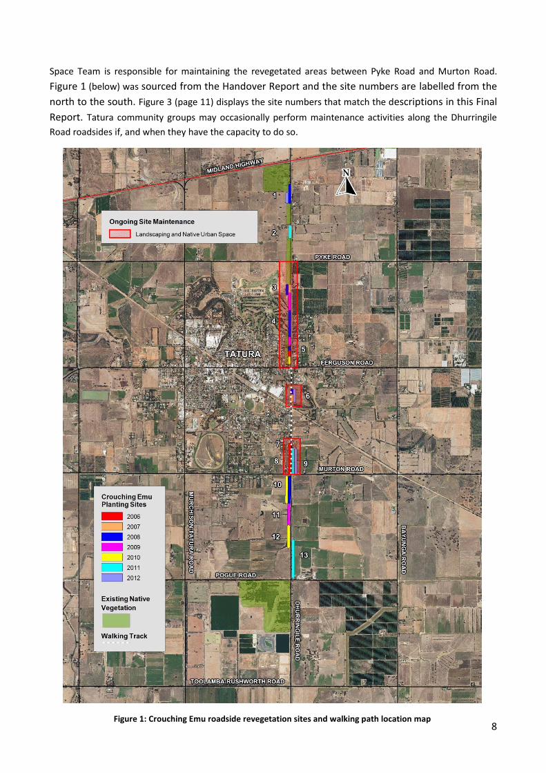
(Austrostipa spp.), Wallaby grasses (Austrodanthonia spp.), Black-anther Flax-lily (Dianella revoluta), Wattle
mat-rush (Lomandra filiformis) and the highly significant species, Variable Glycine (Glycine tabacina) (Figure
2) and Twining Glycine (Glycine clandestina).
The south-west corner of the Dhurringile Road and Midland Highway intersection contains highly significant
remnant native vegetation and has excellent biolink potential. The site contains many large, old Grey Box
trees but also includes a single Buloke (Allocasuarina luehmanii) individual (listed as threatened under the
Flora and Fauna Guarantee (FFG) Act) and two white Cypress-pines (Callitris glaucophylla). These were once
widespread species but now largely absent from the wider landscape.
It was decided that the remnant native vegetation along Dhurringile Road (as well as the large width of the
road reserve) provided an ideal opportunity to create an environmental corridor linking these isolated
vegetation communities and fauna species to the north and south of Tatura.
Figure 2: Variable Glycine (Glycine tabacina) Photo: Phil Hunter 2006
10
4 Project reporting
This Final Project Report compliments and builds upon the findings of three other reports produced for the
project.
4.1 Vegetation survey of Dhurringile Road (Midland Hwy to Sewerage Farm) 2006
This pre-project roadside vegetation survey report was written by Phil Hunter in June 2006 to identify the
native vegetation present along the Dhurringile Road roadside and outline management recommendations
for the project committee to undertake. The report summarised a comprehensive vegetation survey of
Dhurringile Road (undertaken January 2006) to determine the flora species present and assessed the quality
of the vegetation communities within the project area. The report concluded that although large portions of
the roadside were highly disturbed, the vegetation communities and the significant indigenous species
present required considerable conservation priority. This report slightly preceded the formation of the
Crouching Emu Revegetation Project Committee.
4.2 Mid-project Assessment Report 2006 - 2009
The Mid-project Assessment Report 2006 – 2009 was written on behalf of the Committee by Ann Roberts
(Greater Shepparton City Council, Sustainability and Environment Officer) & Travis Turner (Natural Resource
Management student, University of Melbourne). This report detailed the project’s accomplishments for the
first three years and discussed how project activities were progressing in the achievement of the key
objectives. The environmental improvements of the roadside were measured via ecological assessments
across the revegetation sites whilst community surveys were conducted to obtain an understanding of the
attitudes of residents and participant schools. This report also contained recommendations for future
project activities.
4.3 Crouching Emu Revegetation Project Strategic Plan 2011-2015
The Crouching Emu Revegetation Project Strategic Plan 2011-2015 was written by Travis Turner
(Sustainability and Environment Officer, (Greater Shepparton City Council,) and Wendy DÁmore (Project
Officer, Goulburn Murray Landcare Network) with input and guidance from the Committee. The strategic
plan provided a brief overview of the projects accomplishments then outlined the key strategic directions
that remain for the projects objectives to be fully achieved. The plan also listed potential activities to
complete if project funding was extended. The report was submitted to Council with a request for continued
Council funding with an extension of the project. The result was a continuation of Council support and
funding of $6,000 for the 2011/2012 and 2012/2013 financial years.
11
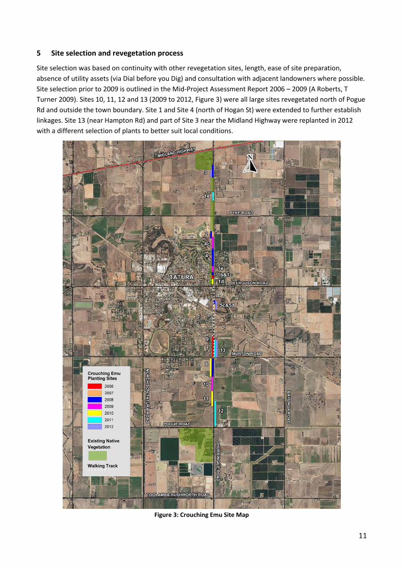
5 Site selection and revegetation process
Site selection was based on continuity with other revegetation sites, length, ease of site preparation,
absence of utility assets (via Dial before you Dig) and consultation with adjacent landowners where possible.
Site selection prior to 2009 is outlined in the Mid-Project Assessment Report 2006 – 2009 (A Roberts, T
Turner 2009). Sites 10, 11, 12 and 13 (2009 to 2012, Figure 3) were all large sites revegetated north of Pogue
Rd and outside the town boundary. Site 1 and Site 4 (north of Hogan St) were extended to further establish
linkages. Site 13 (near Hampton Rd) and part of Site 3 near the Midland Highway were replanted in 2012
with a different selection of plants to better suit local conditions.
Figure 3: Crouching Emu Site Map

12
Site preparation followed protocol from the Department of Primary Industries and Landcare which consisted
of weed spraying, shallow ripping and rotary hoeing or hand digging in sensitive areas, followed by spraying
if timely. Plant selection was determined according to planting site conditions, availability through local
native plant nurseries and consisted primarily of indigenous species. Site planting was either through schools
or the community in conjunction with National Tree Day or by community work crews (chiefly the Mission
Australia National Green Jobs Corps work crew). Committee members monitored sites and conditions and
follow up watering and weed spraying was performed by Council staff or local contractors. Dead plants were
removed at different stages and tree guards were removed after 12 to 18 months by the committee with
assistance from Mooroopna Secondary College students or by the Mission Australia National Green Jobs
Corps work crew.
13
6 Measuring our ecological outcomes (site assessments)
Monitoring, evaluation and assessment comparisons are critical to measuring project progression and
success. Although length of road revegetated or number of individual plants planted are great qualitative
figures that demonstrate project ecological activities, the Crouching Emu Revegetation Project Committee
felt that the best method of communicating the resulting environmental improvements made to the
Dhurringile Road roadside was to conduct quantitative ecological assessments of the revegetated sites over
time.
In December 2008, Travis Turner conducted ecological assessments at the revegetated sites and determined
a pre-revegetation baseline ecological score was from a typical non-revegetated section of the Dhurringile
Road roadside. These results were published in the Mid-Project Assessment Report 2006 – 2009 (A Roberts,
T Turner 2009). Please note that the December 2008 site assessments are referred to in this report as the
2009 assessments because that was when the Mid-Project Report was published. This Final Project Report
reassesses pre-2009 revegetated sites and assesses post-2009 revegetated sites using the same 2009 site
assessment methodology as described below (with a few minor clarifications).
6.1 Ecological assessment methodology
Ecological assessments for this report were conducted by Wendy D’Amore (Goulburn Murray Landcare
Network) in early February 2012. These assessments included sites previously surveyed in December 2008
for the Mid-project Report 2009 (Sites 1 to 9), sites planted in 2010 to 2012 (Sites 10 to 14) but excluded
roadside verges and table drains. Some original sub-sites were combined due to the division of areas being
indistinguishable whilst other sub-sites were created as new plantings had adjoined a previous planting site.
The perimeter of each site or sub-site was measured manually with measuring wheel and recorded using a
Garman™ GPS receiver. Photographs were taken throughout each site and at the north and south most ends
to ensure a visual record of the site was also obtained. The specific location where each photograph was
taken was also recorded with the GPS receiver. Site/sub-site information was recorded using the Crouching
Emu Roadside Ecological Assessment Sheet.
6.1.1 The Crouching Emu Roadside Assessment Sheet
The Crouching Emu Roadside Assessment Sheet (Appendix I) was specially designed for the Project’s
revegetated sites to quantify the ecological improvements to the roadside. The assessment sheet was
adapted from the Roadside Conservation Advisory Committee (RCAC) assessment form and the Department
of Sustainability and Environment’s Habitat Hectares assessment. Our assessment sheet includes
components of both and was developed over several trial sites. The RCAC assessment process is a brief way
of identifying roadside conservation values based on: roadside width, fauna habitat, degree of regeneration,
wildlife corridor, weed cover, site disturbance and presence of rare flora and fauna species. The Habitat
Hectares assessment form assesses the quality of the vegetation in a detailed format used on a national
scale.
The Crouching Emu Roadside Assessment Sheet was used to record all flora species within each site/sub-site
(Appendix II) and ecological characteristics present were scored to give an Ecological Value Score (EVS) to be
used for comparative analysis. Other general site observations were also recorded, including the presence of
on-site utility service assets, the assessment date, assessor name, site identification number, site location,
brief site history, EVC, total area and recommendations noted for future site maintenance.
14
6.1.2 Ecological assessment scoring
As previously discussed, the Committee wanted to measure the environmental improvements achieved by
the Project using quantitative comparative analysis. Quantitative comparative analysis, both between sites
and for the same site over time, requires the allocation of numerical scores according to the degree in which
ecological quality characteristics are achieved. Determining an Ecological Value Score (EVS) for each site/sub-
site was the method used to quantify ecological improvements along the Dhurringile Road roadside. The EVS
was called the Total Conservation Percentage (TCP) in the 2009 report.
The EVS is composed of three key components deemed to be of highest importance in quantifying the
ecological value of each site/sub-site namely:
Native vegetation
Weed cover
Habitat value
The EVS was calculated by adding the individual scores received for each of the ecological components
(native vegetation score, the weed cover score and the habitat value score), dividing this amount by the
maximum possible score that the particular site could receive, and then multiplying this score by 100 to
convert it to a percentage (Equation 1).
Equation 1: Ecological Value Score
Ecological Value Score =
6.1.2.1 Native vegetation
The native vegetation component contained questions regarding the quality of native vegetation present
and was determined by:
The number of native species present (species diversity)
The native vegetation cover (vegetation density)
Occurrence of natural regeneration of shrubs and trees (self-replenishment of the vegetation
present)
The presence of large trees (species and numbers determine the Ecological Vegetation Class (EVC)
present)
Success of any revegetation works (survival rates of planted tube stock).
The native vegetation score is the sum of the scores received for native vegetation cover, natural
regeneration of native trees and shrubs, presence of large trees, native understorey and revegetation
success scores. Each of these sub-components is outlined below.
Native vegetation cover
The native vegetation cover or vegetation density was established by estimating the percentage of the total
area that would be covered by the foliage and stems present if looking down upon the site.
Natural regeneration of native trees and shrubs
Regeneration of native trees and shrubs was scored according to the extent of recruitment that had
occurred for both of these vegetation types. Trees and shrubs were scored separately and were summed to
give a maximum score of six.
Native vegetation score + Weed score + Habitat Score
Maximum possible score for the site ( ) X 100
15
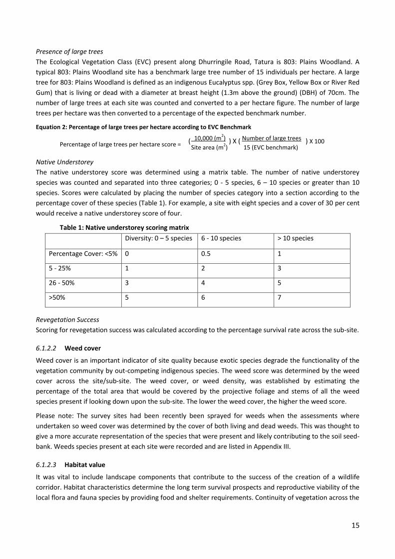
Presence of large trees
The Ecological Vegetation Class (EVC) present along Dhurringile Road, Tatura is 803: Plains Woodland. A
typical 803: Plains Woodland site has a benchmark large tree number of 15 individuals per hectare. A large
tree for 803: Plains Woodland is defined as an indigenous Eucalyptus spp. (Grey Box, Yellow Box or River Red
Gum) that is living or dead with a diameter at breast height (1.3m above the ground) (DBH) of 70cm. The
number of large trees at each site was counted and converted to a per hectare figure. The number of large
trees per hectare was then converted to a percentage of the expected benchmark number.
Equation 2: Percentage of large trees per hectare according to EVC Benchmark
Percentage of large trees per hectare score =
Native Understorey
The native understorey score was determined using a matrix table. The number of native understorey
species was counted and separated into three categories; 0 - 5 species, 6 – 10 species or greater than 10
species. Scores were calculated by placing the number of species category into a section according to the
percentage cover of these species (Table 1). For example, a site with eight species and a cover of 30 per cent
would receive a native understorey score of four.
Table 1: Native understorey scoring matrix
Diversity: 0 – 5 species 6 - 10 species > 10 species
Percentage Cover: <5% 0 0.5 1
5 - 25% 1 2 3
26 - 50% 3 4 5
>50% 5 6 7
Revegetation Success
Scoring for revegetation success was calculated according to the percentage survival rate across the sub-site.
6.1.2.2 Weed cover
Weed cover is an important indicator of site quality because exotic species degrade the functionality of the
vegetation community by out-competing indigenous species. The weed score was determined by the weed
cover across the site/sub-site. The weed cover, or weed density, was established by estimating the
percentage of the total area that would be covered by the projective foliage and stems of all the weed
species present if looking down upon the sub-site. The lower the weed cover, the higher the weed score.
Please note: The survey sites had been recently been sprayed for weeds when the assessments where
undertaken so weed cover was determined by the cover of both living and dead weeds. This was thought to
give a more accurate representation of the species that were present and likely contributing to the soil seed-
bank. Weeds species present at each site were recorded and are listed in Appendix III.
6.1.2.3 Habitat value
It was vital to include landscape components that contribute to the success of the creation of a wildlife
corridor. Habitat characteristics determine the long term survival prospects and reproductive viability of the
local flora and fauna species by providing food and shelter requirements. Continuity of vegetation across the
10,000 (m2) Number of large trees
Site area (m2) 15 (EVC benchmark)
( ) X ( ) X 100
16
landscape allows for greater genetic diversity, by providing safe dispersal passages and increasing the
opportunities for reproduction. Key habitat components determining the potential for establishing a wildlife
corridor are;
Close proximity to hollow bearing trees (important habitat provider for fauna species)
Direct linkages with other areas of native vegetation
Continuity of native vegetation in the surrounding landscape
Presence of native vegetation on adjacent land
The habitat value score was calculated by adding the scores received for presence of dead trees, native
vegetation linkages, wildlife corridor potential and the vegetation on adjacent land.
Presence of hollow bearing trees (alive or dead)
Presence of or close proximity to hollow bearing trees (within ~30m) was scored as either present or absent.
Native vegetation linkage
Linkages with other areas of native vegetation were scored as either present or absent according to whether
native vegetation was directly linked to the sub-site area.
Wildlife corridor potential
The wildlife corridor potential of each sub-site was determined by evaluating the continuity of native
vegetation in the local landscape context. The more continuous the native vegetation, the higher the score
received.
Vegetation on adjacent land
Vegetation on the land adjacent to the sub-site influences the productivity of the vegetation community by
building upon the total area of native vegetation at the site.
6.2 Bird survey methods
A bird survey was conducted along Dhurringile Road throughout the day on 8 March 2012 by Don Roberts
(BirdLife Australia) with assistance from Wendy D'Amore and Michael D'Amore to determine what species
were utilising the Dhurringile Road habitat. The Project was also a recipient of a 2012 Small Community
Action and Education Grant from the GBCMA which allowed the Committee to conduct additional bird
surveys on three adjacent landholder properties during the morning of 31 August 2012.
Birds were identified by sight and/or calls and recorded at 300 metre intervals along Dhurringile Rd. A five
minute period was deemed to be enough time at each interval to identify the bird species present. Species
were recorded whether they were standing, feeding, perching within the site or flying over. Although the
primary focus of the survey was birds, other animal species observed by sight or sound were recorded.
The survey commenced from the north side of the Ferguson Road intersection, starting at Site 1 (opposite
Whim Inn), and then continued northwards to the Midland Highway at 300m intervals along the west side of
the road. Both sides of the road were surveyed on the south side of the Ferguson Road intersection because
planting sites occurred on either side of the road sides (only the west side of road was revegetated to the
north). Due to the interval methodology of the survey, some areas of the road were surveyed that had not
been revegetated, some devoid of native vegetation altogether whilst others had only remnant roadside
trees present.
Birds were identified at the private properties by sight and/or calls whilst walking around the property.
17
6.3 Ecological assessment results - Individual site assessments
A summary of the ecological site assessment and bird survey results for each individual site is provided in
this chapter. The summary for each site includes photographs and management recommendations for future
land managers. The map below (Figure 4) shows the location of each site along Dhurringile Road whilst
individual maps of each site are provided in Appendix VI. These individual site maps contain further details
on the location of utility assets (underground cables and powerlines) and site measurements etc.
Figure 4: Crouching Emu Site Map
18
Site 1: Opposite Generations Church
Site 1 contains the most significant patch of native vegetation along Dhurringile Rd, primarily due to its
species richness, maturity of trees and the significant species present. This site has been adopted by the
Generations Church ACC who has done the majority of the planting and planning for this area in partnership
with Bethel Christian Community College. Site 1 has been expanded since the 2009 report to include land up
to Hogan St (opposite Whim Inn) and to the north to the start of the planting in front of the golf course
(opposite Johnstone St).
Additional understorey plantings have continued across the past three years to increase the native species
diversity and coverage of the site (Figure 5). This site is now part of a continuous environmental corridor
from Hogan St to the Midland Highway to the north. The overall Ecological Value Score (EVS) of this site has
increased from 69% to 79% in the three years since the 2009 assessment. This score has increased over time
due to the increase in species diversity and cover of planted native vegetation and weed removal. Once the
shrubs begin to naturally regenerate the score will increase further.
Figure 5: Site 1 in December 2008 (left) and in again in September 2012 (right).
Sub-sites 1b and 1c identified in the 2009 report were combined during this assessment because these
planting areas are now indistinguishable. This highly valued site contains remnant vegetation that includes
Twining and Variable Glycine (Glycina clandestina and G. tabacina), Spear Grass (Austrostipa spp.), Wattle-
mat Rush (Lomandra filiformis), Black-anther Flax-lily (Dianella revoluta), Wallaby Grass (Austrodanthonia
spp.) and a stand of Yellow Box (Eucalyptus meliodora) and River-red Gums (Eucalyptus camaldulensis). This
is the only known location in the wider Tatura landscape where these species occur naturally together. The
site also contains a mature Golden Wreath-wattle (Acacia saligna) tree, a fine specimen even though a
weedy species outside of its home range.
Sub-site 1d is the southernmost area of the site, opposite Whim
Inn, that had an EVS of 60%. This area has had poor survival rates
of plantings due to a series of factors including poor climatic
conditions during the time of planting, planting technique and
competition from mature trees. Sub-site 1e joins the original
plantings opposite the church to the plantings in front of the golf
course (Site 4). This sub-site had two very large old yellow box
fall during a storm in 2010 (Figure 6), providing an additional
habitat type and visual interest. The EVS for this sub-site was
67%. Site 1d and 1e had relatively high EVSs due to good
Figure 6: large old Yellow Box which fell during a severe storm in 2010 is providing habitats lacking at other Crouching Emu sites.
19
understorey, large trees and native vegetation cover scores.
This site is threatened by woody weed invasion due to its close proximity to the residential area. Many
woody weed species including Desert Ash (Fraxinus angustifolia), Boxthorn (Lycium ferocissimum), Briar
Rose (Rosa rubiginosa), and Privet (Ligustrum lucidum) had returned to the site since the 2009 assessment.
These (and other) weed species were removed from the site in November 2012. The understorey is
dispersed with indigenous grasses and the two species of Glycine so any weed control activity at this site
requires native vegetation specialist supervision.
Bird survey
Site 1 had a total of 18 bird species present, the highest number of bird species recorded of all the sites.
Species recorded included three parrot species (Eastern Rosella (Platycercus eximius), Red-rumped Parrot
(Psephotus haematonotus) and Musk Lorikeet (Glossopsitta concinna)) and two honeyeater species (Blue-
faced Honeyeater (Entomyzon cyanotis) and White-plumed honeyeater (Lichenostomus penicillatus)). An
Azure Kingfisher (Alcedo azurea) had also previously been recorded at this site but was not observed during
the 2012 survey.
Management recommendations
It is important that best practice weed control continues at Site 1 to prevent weed species from
outcompeting the significant native species present but all weed control at this site requires native
vegetation specialist supervision. Many community survey participants requested a walking path to the
north of Hogan St but any path construction would need to be located along the edge of the plantings, not
through them. The path would also need to be carefully placed to ensure little disturbance occurs to the
remnant vegetation. Any activities at this site need to be carefully managed to ensure that disturbance is
kept to an absolute minimum.
Site 2: 200 Dhurringile Road
Site 2 has been a highly successful revegetation site due to the commitment and support provided by the
adjoining landholder. The landholder had been involved during the initial planting day and cared for the
plant through watering and site maintenance. This is particularly the case at sub-site 2c which was planted in
2007 and now contains shrubs between 2.5 to 3 m high (Figure 7). The EVS at sub-site 2c has increased from
48% (in 2009) to 64%. The substantial increase in EVS is due to natural regeneration of Wedge-leaf Hopbush
(Dodonea viscosa), the increased cover of the dense plantings, and the corresponding reduction in weed
species cover.
Figure 7: Site 2 looking south from property driveway in December 2008 and again in September 2012.
20
Site 2b was planted in 2008 and is much patchier with some dense clumps of native plants. The EVS has only
increased from 37% (2009) to 43%. The site scored lower for revegetation success since the 2009 survey due
to a number of plants being lost during the first summer. The reduced revegetation success has resulted in a
patchy cover of native vegetation so the percentage cover of weeds is much higher. Weed species present
include Briar Rose and Nightshade (Solanum spp.).
Bird survey
Eight birds were observed including Magpie, Galah, Musk Lorikeet, Willie Wagtail and Crested Pigeon.
Management recommendations
Continued weed control, particularly in Sub-site 2b.
Site 3: South of the Midland Highway
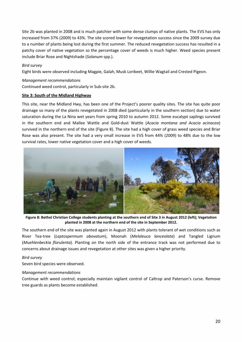
This site, near the Midland Hwy, has been one of the Project’s poorer quality sites. The site has quite poor
drainage so many of the plants revegetated in 2008 died (particularly in the southern section) due to water
saturation during the La Nina wet years from spring 2010 to autumn 2012. Some eucalypt saplings survived
in the southern end and Mallee Wattle and Gold-dust Wattle (Acacia montana and Acacia acinacea)
survived in the northern end of the site (Figure 8). The site had a high cover of grass weed species and Briar
Rose was also present. The site had a very small increase in EVS from 44% (2009) to 48% due to the low
survival rates, lower native vegetation cover and a high cover of weeds.
Figure 8: Bethel Christian College students planting at the southern end of Site 3 in August 2012 (left); Vegetation
planted in 2008 at the northern end of the site in September 2012.
The southern end of the site was planted again in August 2012 with plants tolerant of wet conditions such as
River Tea-tree (Leptospermum obovatum), Moonah (Melaleuca lanceolata) and Tangled Lignum
(Muehlenbeckia florulenta). Planting on the north side of the entrance track was not performed due to
concerns about drainage issues and revegetation at other sites was given a higher priority.
Bird survey
Seven bird species were observed.
Management recommendations
Continue with weed control; especially maintain vigilant control of Caltrop and Paterson’s curse. Remove
tree guards as plants become established.
21
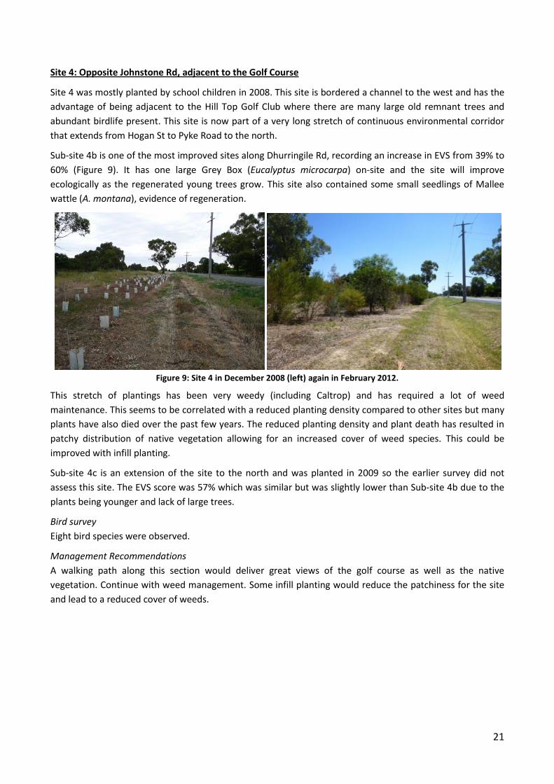
Site 4: Opposite Johnstone Rd, adjacent to the Golf Course
Site 4 was mostly planted by school children in 2008. This site is bordered a channel to the west and has the
advantage of being adjacent to the Hill Top Golf Club where there are many large old remnant trees and
abundant birdlife present. This site is now part of a very long stretch of continuous environmental corridor
that extends from Hogan St to Pyke Road to the north.
Sub-site 4b is one of the most improved sites along Dhurringile Rd, recording an increase in EVS from 39% to
60% (Figure 9). It has one large Grey Box (Eucalyptus microcarpa) on-site and the site will improve
ecologically as the regenerated young trees grow. This site also contained some small seedlings of Mallee
wattle (A. montana), evidence of regeneration.
Figure 9: Site 4 in December 2008 (left) again in February 2012.
This stretch of plantings has been very weedy (including Caltrop) and has required a lot of weed
maintenance. This seems to be correlated with a reduced planting density compared to other sites but many
plants have also died over the past few years. The reduced planting density and plant death has resulted in
patchy distribution of native vegetation allowing for an increased cover of weed species. This could be
improved with infill planting.
Sub-site 4c is an extension of the site to the north and was planted in 2009 so the earlier survey did not
assess this site. The EVS score was 57% which was similar but was slightly lower than Sub-site 4b due to the
plants being younger and lack of large trees.
Bird survey
Eight bird species were observed.
Management Recommendations
A walking path along this section would deliver great views of the golf course as well as the native
vegetation. Continue with weed management. Some infill planting would reduce the patchiness for the site
and lead to a reduced cover of weeds.
22
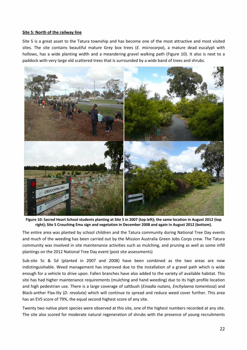
Site 5: North of the railway line
Site 5 is a great asset to the Tatura township and has become one of the most attractive and most visited
sites. The site contains beautiful mature Grey box trees (E. microcarpa), a mature dead eucalypt with
hollows, has a wide planting width and a meandering gravel walking path (Figure 10). It also is next to a
paddock with very large old scattered trees that is surrounded by a wide band of trees and shrubs.
Figure 10: Sacred Heart School students planting at Site 5 in 2007 (top left); the same location in August 2012 (top
right); Site 5 Crouching Emu sign and vegetation in December 2008 and again in August 2012 (bottom).
The entire area was planted by school children and the Tatura community during National Tree Day events
and much of the weeding has been carried out by the Mission Australia Green Jobs Corps crew. The Tatura
community was involved in site maintenance activities such as mulching, and pruning as well as some infill
plantings on the 2012 National Tree Day event (post site assessments)
Sub-site 5c & 5d (planted in 2007 and 2008) have been combined as the two areas are now
indistinguishable. Weed management has improved due to the installation of a gravel path which is wide
enough for a vehicle to drive upon. Fallen branches have also added to the variety of available habitat. This
site has had higher maintenance requirements (mulching and hand weeding) due to its high profile location
and high pedestrian use. There is a large coverage of saltbush (Einadia nutans, Enchylaena tomentosa) and
Black-anther Flax-lily (D. revoluta) which will continue to spread and reduce weed cover further. This area
has an EVS score of 79%, the equal second highest score of any site.
Twenty two native plant species were observed at this site, one of the highest numbers recorded at any site.
The site also scored for moderate natural regeneration of shrubs with the presence of young recruitments
23
from three shrub species, Mallee and Golden Wattles (Acacia montana, Acacia pycnantha) and Hop-bush
(Dodonea spp.).
Sub-site 5b has remained unplanted because of a reasonable cover of native grasses (mainly Wallaby Grass
(Austrodanthonia spp.) and Windmill Grass (Chloris truncate)). In the summer of 2010 and 2011 several
Chilean Needle Grass (Nassella neesiana) plants , a Weed of National Significance declared noxious weed,
were identified and destroyed.
Bird survey
Five bird species were observed.
Management recommendations
The site will require continued monitoring for Chillean Needle Grass and Caltrop, especially in the grassy
area. Slashing is a known method of Chilean Needle Grass seed spread so care must be taken here. Continue
to prune, remove dead bushes, mulch and spot weed spray to keep weeds at bay. The provision of seating at
this site is recommended.
Site 7: Between Hampton and Murton Rds
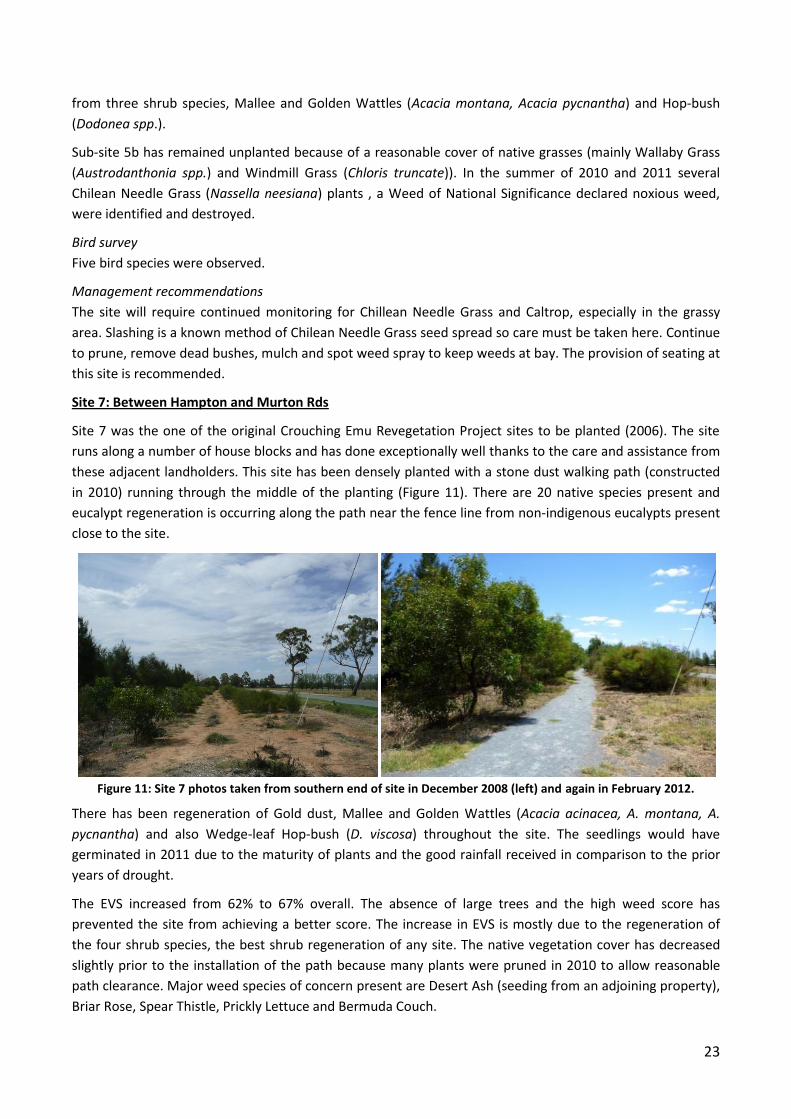
Site 7 was the one of the original Crouching Emu Revegetation Project sites to be planted (2006). The site
runs along a number of house blocks and has done exceptionally well thanks to the care and assistance from
these adjacent landholders. This site has been densely planted with a stone dust walking path (constructed
in 2010) running through the middle of the planting (Figure 11). There are 20 native species present and
eucalypt regeneration is occurring along the path near the fence line from non-indigenous eucalypts present
close to the site.
Figure 11: Site 7 photos taken from southern end of site in December 2008 (left) and again in February 2012.
There has been regeneration of Gold dust, Mallee and Golden Wattles (Acacia acinacea, A. montana, A.
pycnantha) and also Wedge-leaf Hop-bush (D. viscosa) throughout the site. The seedlings would have
germinated in 2011 due to the maturity of plants and the good rainfall received in comparison to the prior
years of drought.
The EVS increased from 62% to 67% overall. The absence of large trees and the high weed score has
prevented the site from achieving a better score. The increase in EVS is mostly due to the regeneration of
the four shrub species, the best shrub regeneration of any site. The native vegetation cover has decreased
slightly prior to the installation of the path because many plants were pruned in 2010 to allow reasonable
path clearance. Major weed species of concern present are Desert Ash (seeding from an adjoining property),
Briar Rose, Spear Thistle, Prickly Lettuce and Bermuda Couch.
24
Bird survey
Five bird species were observed including Superb Fairy-wrens, a Red Wattlebird, and a White-plumed
Honeyeater. It is one of the few sites that had Superb Fairy-wrens present. The density of the shrub mid-
layer and the variety of plant species may be responsible for their presence. A Common Froglet was also
heard calling at the site.
Management recommendations
Weed control needs to be continued in this site but care must be taken to ensure that the regeneration of
native seedlings is not impacted upon. Prune plants as they continue to mature and encroach upon the track
and remove dead shrubs annually. As plants are removed, efforts should be made to replant with
groundcovers or low growing shrubs to allow visual breaks in the corridor for pedestrians.
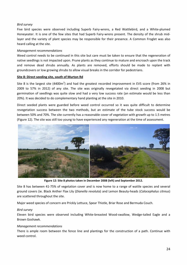
Site 8: Direct seeding site, south of Murton Rd
Site 8 is the largest site (4400m2) and had the greatest recorded improvement in EVS score (from 26% in
2009 to 57% in 2012) of any site. The site was originally revegetated via direct seeding in 2008 but
germination of seedlings was quite slow and had a very low success rate (an estimate would be less than
20%). It was decided to do complementary hand planting at the site in 2010.
Direct seeded plants were guarded before weed control occurred so it was quite difficult to determine
revegetation success between the two methods, but an estimate of the tube stock success would be
between 50% and 70%. The site currently has a reasonable cover of vegetation with growth up to 1.5 metres
(Figure 12). The site was still too young to have experienced any regeneration at the time of assessment.
Figure 12: Site 8 photos taken in December 2008 (left) and September 2012.
Site 8 has between 41-75% of vegetation cover and is now home to a range of wattle species and several
ground covers (ie. Black Anther Flax Lily (Dianella revoluta) and Lemon Beauty-heads (Calocephalus citreus)
are scattered throughout the site.
Major weed species of concern are Prickly Lettuce, Spear Thistle, Briar Rose and Bermuda Couch.
Bird survey
Eleven bird species were observed including White-breasted Wood-swallow, Wedge-tailed Eagle and a
Brown Goshawk.
Management recommendations
There is ample room between the fence line and plantings for the construction of a path. Continue with
weed control.
25
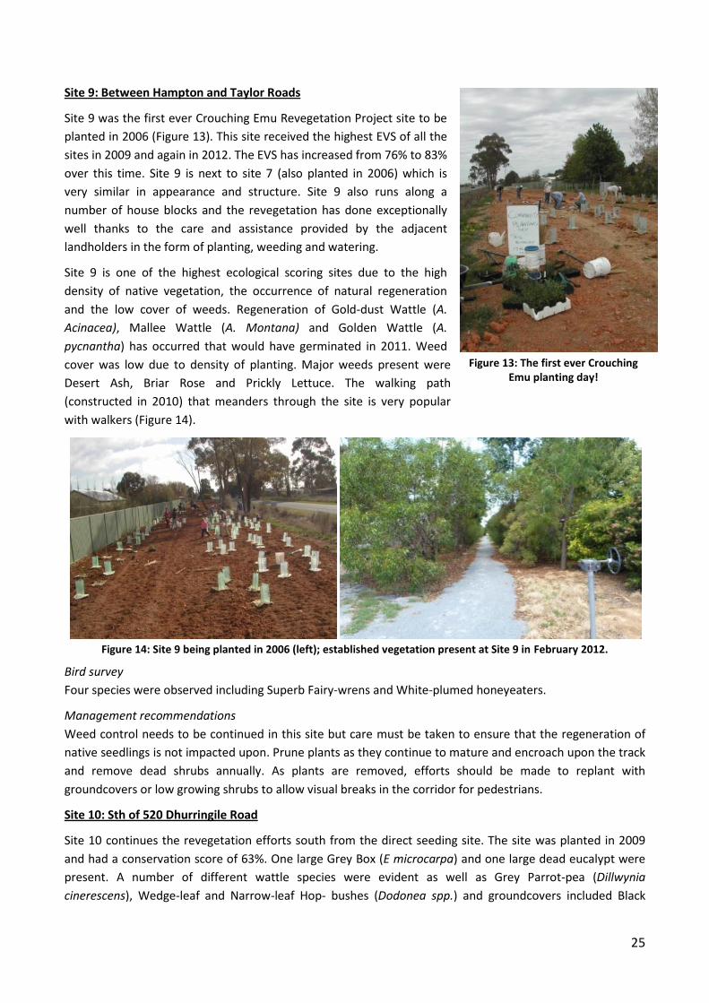
Site 9: Between Hampton and Taylor Roads
Site 9 was the first ever Crouching Emu Revegetation Project site to be
planted in 2006 (Figure 13). This site received the highest EVS of all the
sites in 2009 and again in 2012. The EVS has increased from 76% to 83%
over this time. Site 9 is next to site 7 (also planted in 2006) which is
very similar in appearance and structure. Site 9 also runs along a
number of house blocks and the revegetation has done exceptionally
well thanks to the care and assistance provided by the adjacent
landholders in the form of planting, weeding and watering.
Site 9 is one of the highest ecological scoring sites due to the high
density of native vegetation, the occurrence of natural regeneration
and the low cover of weeds. Regeneration of Gold-dust Wattle (A.
Acinacea), Mallee Wattle (A. Montana) and Golden Wattle (A.
pycnantha) has occurred that would have germinated in 2011. Weed
cover was low due to density of planting. Major weeds present were
Desert Ash, Briar Rose and Prickly Lettuce. The walking path
(constructed in 2010) that meanders through the site is very popular
with walkers (Figure 14).
Figure 14: Site 9 being planted in 2006 (left); established vegetation present at Site 9 in February 2012.
Bird survey
Four species were observed including Superb Fairy-wrens and White-plumed honeyeaters.
Management recommendations
Weed control needs to be continued in this site but care must be taken to ensure that the regeneration of
native seedlings is not impacted upon. Prune plants as they continue to mature and encroach upon the track
and remove dead shrubs annually. As plants are removed, efforts should be made to replant with
groundcovers or low growing shrubs to allow visual breaks in the corridor for pedestrians.
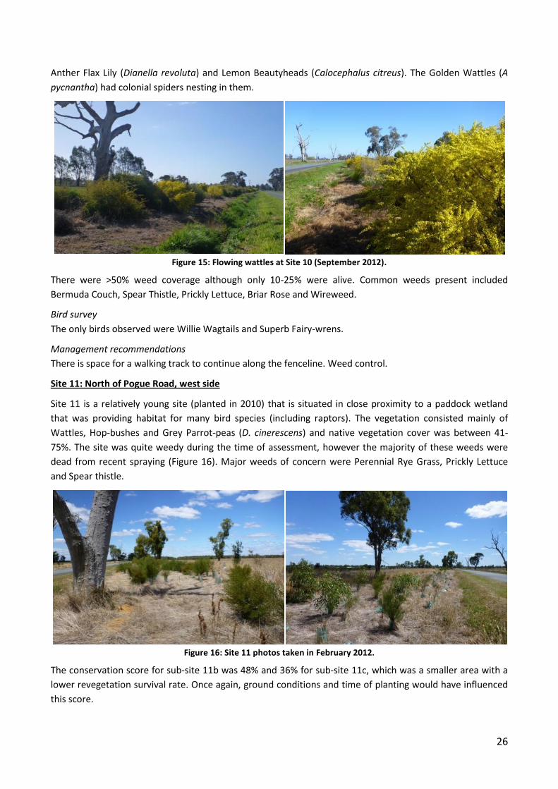
Site 10: Sth of 520 Dhurringile Road
Site 10 continues the revegetation efforts south from the direct seeding site. The site was planted in 2009
and had a conservation score of 63%. One large Grey Box (E microcarpa) and one large dead eucalypt were
present. A number of different wattle species were evident as well as Grey Parrot-pea (Dillwynia
cinerescens), Wedge-leaf and Narrow-leaf Hop- bushes (Dodonea spp.) and groundcovers included Black
Figure 13: The first ever Crouching Emu planting day!
26
Anther Flax Lily (Dianella revoluta) and Lemon Beautyheads (Calocephalus citreus). The Golden Wattles (A
pycnantha) had colonial spiders nesting in them.
Figure 15: Flowing wattles at Site 10 (September 2012).
There were >50% weed coverage although only 10-25% were alive. Common weeds present included
Bermuda Couch, Spear Thistle, Prickly Lettuce, Briar Rose and Wireweed.
Bird survey
The only birds observed were Willie Wagtails and Superb Fairy-wrens.
Management recommendations
There is space for a walking track to continue along the fenceline. Weed control.
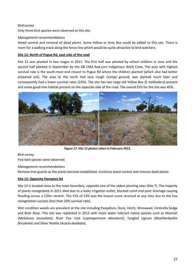
Site 11: North of Pogue Road, west side
Site 11 is a relatively young site (planted in 2010) that is situated in close proximity to a paddock wetland
that was providing habitat for many bird species (including raptors). The vegetation consisted mainly of
Wattles, Hop-bushes and Grey Parrot-peas (D. cinerescens) and native vegetation cover was between 41-
75%. The site was quite weedy during the time of assessment, however the majority of these weeds were
dead from recent spraying (Figure 16). Major weeds of concern were Perennial Rye Grass, Prickly Lettuce
and Spear thistle.
Figure 16: Site 11 photos taken in February 2012.
The conservation score for sub-site 11b was 48% and 36% for sub-site 11c, which was a smaller area with a
lower revegetation survival rate. Once again, ground conditions and time of planting would have influenced
this score.
27
Bird survey
Only three bird species were observed at this site.
Management recommendations
Weed control and removal of dead plants. Some Yellow or Grey Box could be added to this site. There is
room for a walking track along the fence line which would be quite attractive to bird watchers.
Site 12: North of Pogue Rd, east side of the road
Site 12 was planted in two stages in 2011. The first half was planted by school children in June and the
second half planted in September by the GB CMA Rad.com Indigenous Work Crew. The area with highest
survival rate is the south-most end closest to Pogue Rd where the children planted (which also had better
prepared soil). The area to the north had very rough clumpy ground, was planted much later and
consequently had a lower survival rates (23%). The site has two large old Yellow Box (E melliodora) present
and some good tree habitat present on the opposite side of the road. The overall EVS for the site was 45%.
Figure 17: Site 12 photos taken in February 2012.
Bird survey
Five bird species were observed.
Management recommendations
Remove tree guards as the plants become established. Continue weed control and remove dead plants.
Site 13: Opposite Hampton Rd
Site 13 is located close to the town boundary, opposite one of the oldest planting sites (Site 7). The majority
of plants revegetated in 2011 died due to a leaky irrigation outlet, blocked culvit and poor drainage causing
flooding across a 120m stretch. This EVS of 23% was the lowest score received at any sites due to the low
revegetation success (less than 20% survival rate).
Wet condition weeds are prevalent at the site including Paspallum, Dock, Vetch, Wireweed, Umbrella Sedge
and Briar Rose. This site was replanted in 2012 with more water tolerant native species such as Moonah
(Melaleuca lanceolata), River Tea- tree (Leptospermum obovatum), Tangled Lignum (Muehlenbeckia
florulenta) and Silver Wattle (Acacia dealbata).
28
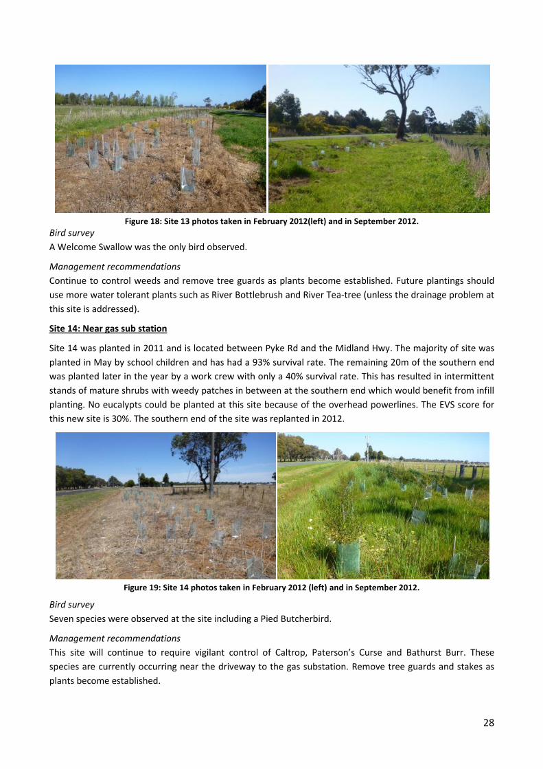
Figure 18: Site 13 photos taken in February 2012(left) and in September 2012.
Bird survey
A Welcome Swallow was the only bird observed.
Management recommendations
Continue to control weeds and remove tree guards as plants become established. Future plantings should
use more water tolerant plants such as River Bottlebrush and River Tea-tree (unless the drainage problem at
this site is addressed).
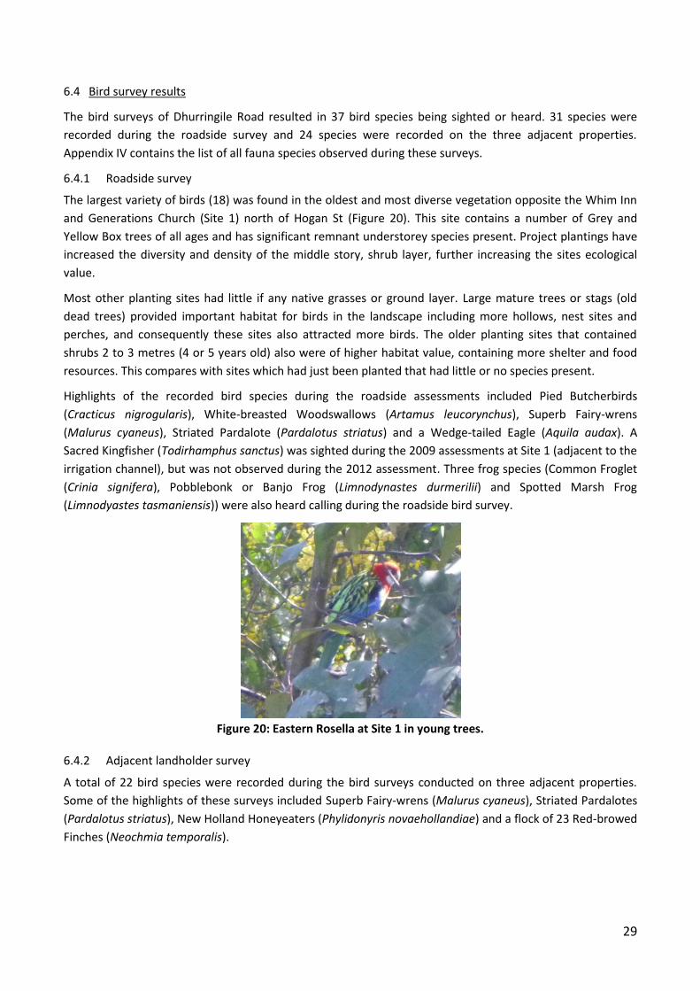
Site 14: Near gas sub station
Site 14 was planted in 2011 and is located between Pyke Rd and the Midland Hwy. The majority of site was
planted in May by school children and has had a 93% survival rate. The remaining 20m of the southern end
was planted later in the year by a work crew with only a 40% survival rate. This has resulted in intermittent
stands of mature shrubs with weedy patches in between at the southern end which would benefit from infill
planting. No eucalypts could be planted at this site because of the overhead powerlines. The EVS score for
this new site is 30%. The southern end of the site was replanted in 2012.
Figure 19: Site 14 photos taken in February 2012 (left) and in September 2012.
Bird survey
Seven species were observed at the site including a Pied Butcherbird.
Management recommendations
This site will continue to require vigilant control of Caltrop, Paterson’s Curse and Bathurst Burr. These
species are currently occurring near the driveway to the gas substation. Remove tree guards and stakes as
plants become established.
29
6.4 Bird survey results
The bird surveys of Dhurringile Road resulted in 37 bird species being sighted or heard. 31 species were
recorded during the roadside survey and 24 species were recorded on the three adjacent properties.
Appendix IV contains the list of all fauna species observed during these surveys.
6.4.1 Roadside survey
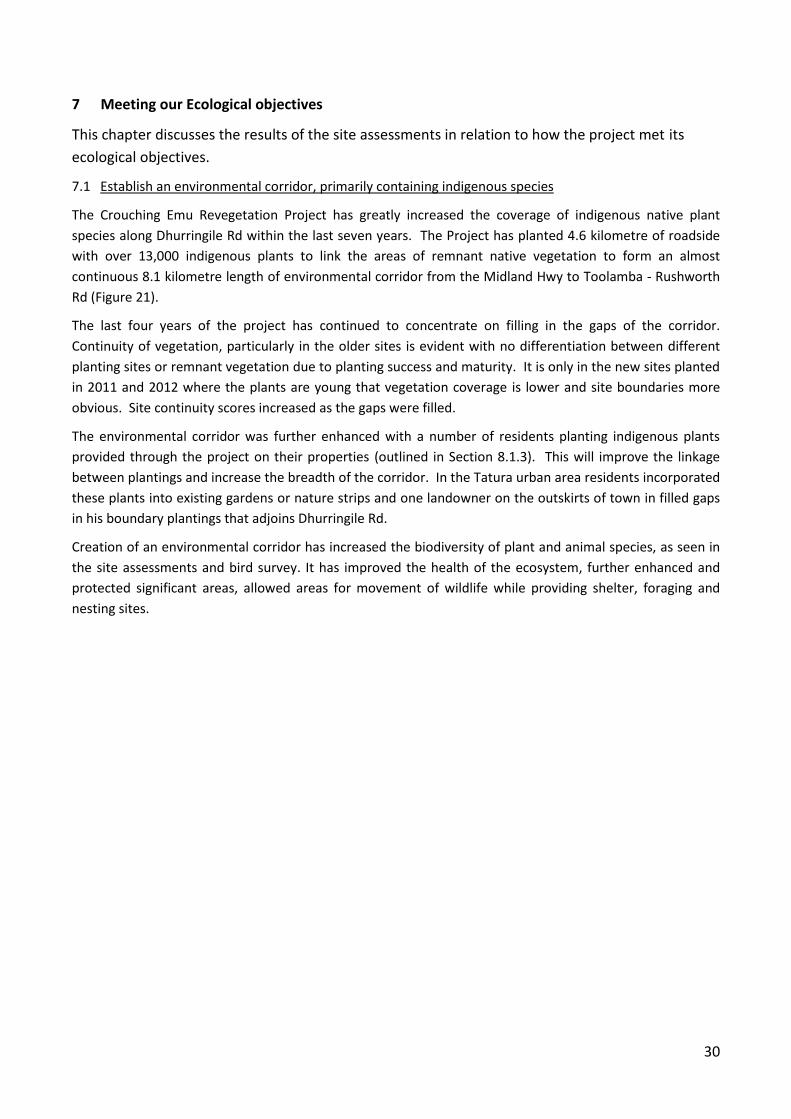
The largest variety of birds (18) was found in the oldest and most diverse vegetation opposite the Whim Inn
and Generations Church (Site 1) north of Hogan St (Figure 20). This site contains a number of Grey and
Yellow Box trees of all ages and has significant remnant understorey species present. Project plantings have
increased the diversity and density of the middle story, shrub layer, further increasing the sites ecological
value.
Most other planting sites had little if any native grasses or ground layer. Large mature trees or stags (old
dead trees) provided important habitat for birds in the landscape including more hollows, nest sites and
perches, and consequently these sites also attracted more birds. The older planting sites that contained
shrubs 2 to 3 metres (4 or 5 years old) also were of higher habitat value, containing more shelter and food
resources. This compares with sites which had just been planted that had little or no species present.
Highlights of the recorded bird species during the roadside assessments included Pied Butcherbirds
(Cracticus nigrogularis), White-breasted Woodswallows (Artamus leucorynchus), Superb Fairy-wrens
(Malurus cyaneus), Striated Pardalote (Pardalotus striatus) and a Wedge-tailed Eagle (Aquila audax). A
Sacred Kingfisher (Todirhamphus sanctus) was sighted during the 2009 assessments at Site 1 (adjacent to the
irrigation channel), but was not observed during the 2012 assessment. Three frog species (Common Froglet
(Crinia signifera), Pobblebonk or Banjo Frog (Limnodynastes durmerilii) and Spotted Marsh Frog
(Limnodyastes tasmaniensis)) were also heard calling during the roadside bird survey.
Figure 20: Eastern Rosella at Site 1 in young trees.
6.4.2 Adjacent landholder survey
A total of 22 bird species were recorded during the bird surveys conducted on three adjacent properties.
Some of the highlights of these surveys included Superb Fairy-wrens (Malurus cyaneus), Striated Pardalotes
(Pardalotus striatus), New Holland Honeyeaters (Phylidonyris novaehollandiae) and a flock of 23 Red-browed
Finches (Neochmia temporalis).
30
7 Meeting our Ecological objectives
This chapter discusses the results of the site assessments in relation to how the project met its
ecological objectives.
7.1 Establish an environmental corridor, primarily containing indigenous species
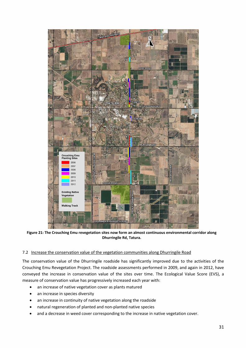
The Crouching Emu Revegetation Project has greatly increased the coverage of indigenous native plant
species along Dhurringile Rd within the last seven years. The Project has planted 4.6 kilometre of roadside
with over 13,000 indigenous plants to link the areas of remnant native vegetation to form an almost
continuous 8.1 kilometre length of environmental corridor from the Midland Hwy to Toolamba - Rushworth
Rd (Figure 21).
The last four years of the project has continued to concentrate on filling in the gaps of the corridor.
Continuity of vegetation, particularly in the older sites is evident with no differentiation between different
planting sites or remnant vegetation due to planting success and maturity. It is only in the new sites planted
in 2011 and 2012 where the plants are young that vegetation coverage is lower and site boundaries more
obvious. Site continuity scores increased as the gaps were filled.
The environmental corridor was further enhanced with a number of residents planting indigenous plants
provided through the project on their properties (outlined in Section 8.1.3). This will improve the linkage
between plantings and increase the breadth of the corridor. In the Tatura urban area residents incorporated
these plants into existing gardens or nature strips and one landowner on the outskirts of town in filled gaps
in his boundary plantings that adjoins Dhurringile Rd.
Creation of an environmental corridor has increased the biodiversity of plant and animal species, as seen in
the site assessments and bird survey. It has improved the health of the ecosystem, further enhanced and
protected significant areas, allowed areas for movement of wildlife while providing shelter, foraging and
nesting sites.
31
Figure 21: The Crouching Emu revegetation sites now form an almost continuous environmental corridor along
Dhurringile Rd, Tatura.
7.2 Increase the conservation value of the vegetation communities along Dhurringile Road
The conservation value of the Dhurringile roadside has significantly improved due to the activities of the
Crouching Emu Revegetation Project. The roadside assessments performed in 2009, and again in 2012, have
conveyed the increase in conservation value of the sites over time. The Ecological Value Score (EVS), a
measure of conservation value has progressively increased each year with:
an increase of native vegetation cover as plants matured
an increase in species diversity
an increase in continuity of native vegetation along the roadside
natural regeneration of planted and non-planted native species
and a decrease in weed cover corresponding to the increase in native vegetation cover.
32
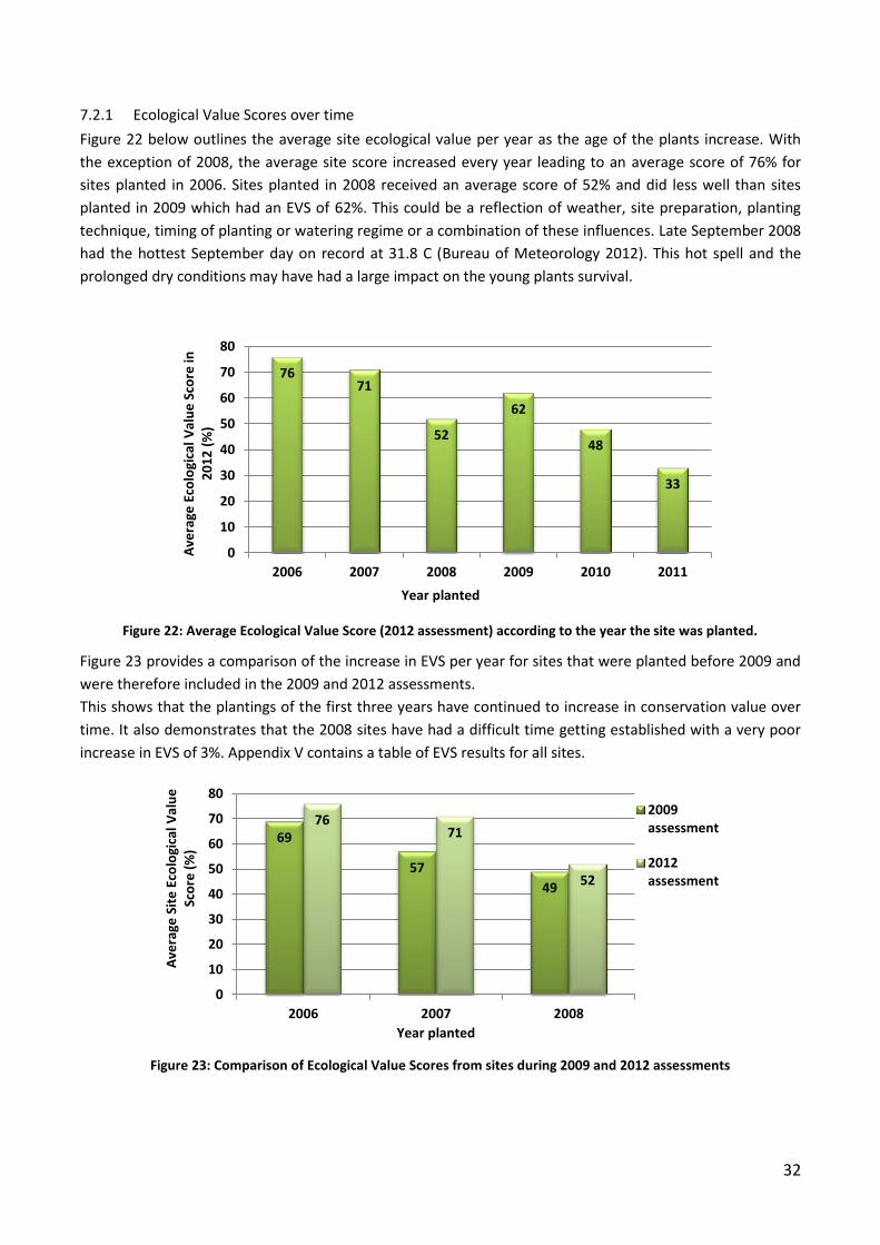
7.2.1 Ecological Value Scores over time
Figure 22 below outlines the average site ecological value per year as the age of the plants increase. With
the exception of 2008, the average site score increased every year leading to an average score of 76% for
sites planted in 2006. Sites planted in 2008 received an average score of 52% and did less well than sites
planted in 2009 which had an EVS of 62%. This could be a reflection of weather, site preparation, planting
technique, timing of planting or watering regime or a combination of these influences. Late September 2008
had the hottest September day on record at 31.8 C (Bureau of Meteorology 2012). This hot spell and the
prolonged dry conditions may have had a large impact on the young plants survival.
Figure 22: Average Ecological Value Score (2012 assessment) according to the year the site was planted.
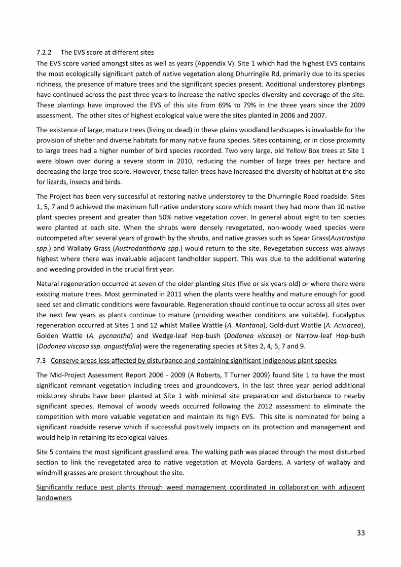
Figure 23 provides a comparison of the increase in EVS per year for sites that were planted before 2009 and
were therefore included in the 2009 and 2012 assessments.
This shows that the plantings of the first three years have continued to increase in conservation value over
time. It also demonstrates that the 2008 sites have had a difficult time getting established with a very poor
increase in EVS of 3%. Appendix V contains a table of EVS results for all sites.
Figure 23: Comparison of Ecological Value Scores from sites during 2009 and 2012 assessments
76 71
52
62
48
33
0
10
20
30
40
50
60
70
80
2006 2007 2008 2009 2010 2011
Ave
rage
Eco
logi
cal V
alu
e S
core
in
20
12
(%
)
Year planted
69
57
49
76 71
52
0
10
20
30
40
50
60
70
80
2006 2007 2008
Ave
rage
Sit
e E
colo
gica
l Val
ue
Sc
ore
(%
)
Year planted
2009assessment
2012assessment
33
7.2.2 The EVS score at different sites
The EVS score varied amongst sites as well as years (Appendix V). Site 1 which had the highest EVS contains
the most ecologically significant patch of native vegetation along Dhurringile Rd, primarily due to its species
richness, the presence of mature trees and the significant species present. Additional understorey plantings
have continued across the past three years to increase the native species diversity and coverage of the site.
These plantings have improved the EVS of this site from 69% to 79% in the three years since the 2009
assessment. The other sites of highest ecological value were the sites planted in 2006 and 2007.
The existence of large, mature trees (living or dead) in these plains woodland landscapes is invaluable for the
provision of shelter and diverse habitats for many native fauna species. Sites containing, or in close proximity
to large trees had a higher number of bird species recorded. Two very large, old Yellow Box trees at Site 1
were blown over during a severe storm in 2010, reducing the number of large trees per hectare and
decreasing the large tree score. However, these fallen trees have increased the diversity of habitat at the site
for lizards, insects and birds.
The Project has been very successful at restoring native understorey to the Dhurringile Road roadside. Sites
1, 5, 7 and 9 achieved the maximum full native understory score which meant they had more than 10 native
plant species present and greater than 50% native vegetation cover. In general about eight to ten species
were planted at each site. When the shrubs were densely revegetated, non-woody weed species were
outcompeted after several years of growth by the shrubs, and native grasses such as Spear Grass(Austrostipa
spp.) and Wallaby Grass (Austrodanthonia spp.) would return to the site. Revegetation success was always
highest where there was invaluable adjacent landholder support. This was due to the additional watering
and weeding provided in the crucial first year.
Natural regeneration occurred at seven of the older planting sites (five or six years old) or where there were
existing mature trees. Most germinated in 2011 when the plants were healthy and mature enough for good
seed set and climatic conditions were favourable. Regeneration should continue to occur across all sites over
the next few years as plants continue to mature (providing weather conditions are suitable). Eucalyptus
regeneration occurred at Sites 1 and 12 whilst Mallee Wattle (A. Montana), Gold-dust Wattle (A. Acinacea),
Golden Wattle (A. pycnantha) and Wedge-leaf Hop-bush (Dodonea viscosa) or Narrow-leaf Hop-bush
(Dodonea viscosa ssp. angustifolia) were the regenerating species at Sites 2, 4, 5, 7 and 9.
7.3 Conserve areas less affected by disturbance and containing significant indigenous plant species
The Mid-Project Assessment Report 2006 - 2009 (A Roberts, T Turner 2009) found Site 1 to have the most
significant remnant vegetation including trees and groundcovers. In the last three year period additional
midstorey shrubs have been planted at Site 1 with minimal site preparation and disturbance to nearby
significant species. Removal of woody weeds occurred following the 2012 assessment to eliminate the
competition with more valuable vegetation and maintain its high EVS. This site is nominated for being a
significant roadside reserve which if successful positively impacts on its protection and management and
would help in retaining its ecological values.
Site 5 contains the most significant grassland area. The walking path was placed through the most disturbed
section to link the revegetated area to native vegetation at Moyola Gardens. A variety of wallaby and
windmill grasses are present throughout the site.
Significantly reduce pest plants through weed management coordinated in collaboration with adjacent
landowners
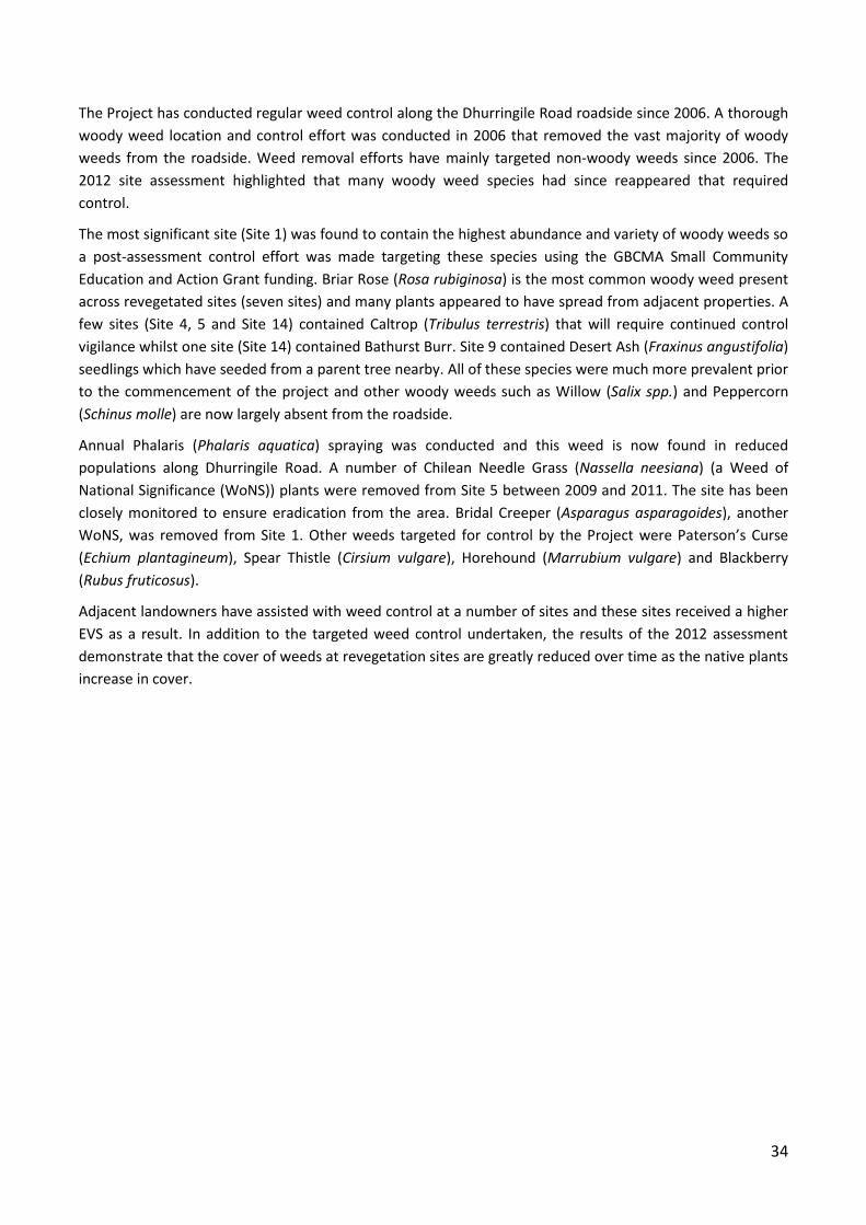
34
The Project has conducted regular weed control along the Dhurringile Road roadside since 2006. A thorough
woody weed location and control effort was conducted in 2006 that removed the vast majority of woody
weeds from the roadside. Weed removal efforts have mainly targeted non-woody weeds since 2006. The
2012 site assessment highlighted that many woody weed species had since reappeared that required
control.
The most significant site (Site 1) was found to contain the highest abundance and variety of woody weeds so
a post-assessment control effort was made targeting these species using the GBCMA Small Community
Education and Action Grant funding. Briar Rose (Rosa rubiginosa) is the most common woody weed present
across revegetated sites (seven sites) and many plants appeared to have spread from adjacent properties. A
few sites (Site 4, 5 and Site 14) contained Caltrop (Tribulus terrestris) that will require continued control
vigilance whilst one site (Site 14) contained Bathurst Burr. Site 9 contained Desert Ash (Fraxinus angustifolia)
seedlings which have seeded from a parent tree nearby. All of these species were much more prevalent prior
to the commencement of the project and other woody weeds such as Willow (Salix spp.) and Peppercorn
(Schinus molle) are now largely absent from the roadside.
Annual Phalaris (Phalaris aquatica) spraying was conducted and this weed is now found in reduced
populations along Dhurringile Road. A number of Chilean Needle Grass (Nassella neesiana) (a Weed of
National Significance (WoNS)) plants were removed from Site 5 between 2009 and 2011. The site has been
closely monitored to ensure eradication from the area. Bridal Creeper (Asparagus asparagoides), another
WoNS, was removed from Site 1. Other weeds targeted for control by the Project were Paterson’s Curse
(Echium plantagineum), Spear Thistle (Cirsium vulgare), Horehound (Marrubium vulgare) and Blackberry
(Rubus fruticosus).
Adjacent landowners have assisted with weed control at a number of sites and these sites received a higher
EVS as a result. In addition to the targeted weed control undertaken, the results of the 2012 assessment
demonstrate that the cover of weeds at revegetation sites are greatly reduced over time as the native plants
increase in cover.
35
8 Achieving our community awareness and education objectives
This chapter provides an outline of the many community awareness and education activities the Crouching
Emu Revegetation Project has undertaken and discusses the results of the community and school surveys in
relation to these activities.
8.1 Significant community awareness and engagement activities
8.1.1 National Tree Day 2006 - 2012
National Tree Day has continued to be a major community and school event. Planet Ark National Tree Day
provides a National focus on doing something positive for the natural environment while providing support
and insurance for the event. Each year the community including local Landcare volunteers were invited to
plant at a selected registered National Tree Day site within the Tatura township. The upcoming event was
advertised in the Tatura Bulletin, Tatura Guardian, Shepparton News and school newsletters.
The committee organised specific sites for Schools
National Tree Day which were held over 2 or 3 days.
The three primary schools of Tatura (Bethel Christian
College, Sacred Heart School and Tatura Primary
School) and Mooroopna Secondary College have
participated in the Crouching Emu Revegetation Project
over the last 6 years. These planting days have left the
students with the feeling that they are contributing not
only to their local environment but also that they are
participating in an Australian wide environmental
event. The Planet Ark connection also provided
teachers with access to educational resources
specifically tailored for Schools Tree Day and provided
ideas for other environmental learning activities.
Site preparation and the coordination of the schools and volunteers were key factors in the success of these
days. The Schools Tree Days always featured in the Tatura Guardian highlighting to the community the
wonderful contributions made by the local children. The school children of Tatura, with the help of
Mooroopna Secondary College students, have planted more than 5,000 plants along Dhurringile Road.
8.1.2 Tidy Town Awards 2011
The Crouching Emu Revegetation Project was nominated for two Keep Australia Beautiful Tidy Town –
Sustainable Communities Awards in 2011. The two award categories were Community Government
Partnerships and Protection of the Environment and the Project was a State Finalist in the Community
Government Partnership category. A celebration event was organised at Site 5 on Dhurringile Rd in July 2011
to show case the projects achievements to Tidy Towns Judge, Ron Williamson before the finalists were
announced. Thirty two people attended the event including the Mission Australia youth workcrew,
representatives from Greater Shepparton City Council, Department of Primary Industries, Transition Tatura,
Dhurringile Road residents and Tatura community members. The Tidy Towns Judge was given a guided tour
along the walking path through the roadside revegetation, and then taken for a drive along Dhurringile Rd to
appreciate the full extent of the projects activities. Both print and television media were involved in
reporting the event. The committee was presented with a finalist certificate and invited to attend the Tidy
Towns- Sustainable Communities Awards in October (Figure 25).
Figure 24: Sacred Heart School students planting at Site 5 (2007)
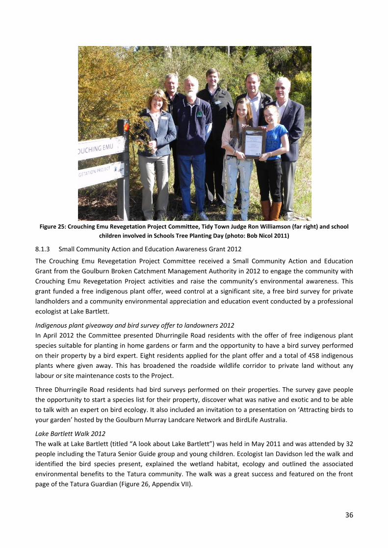
36
Figure 25: Crouching Emu Revegetation Project Committee, Tidy Town Judge Ron Williamson (far right) and school
children involved in Schools Tree Planting Day (photo: Bob Nicol 2011)
8.1.3 Small Community Action and Education Awareness Grant 2012
The Crouching Emu Revegetation Project Committee received a Small Community Action and Education
Grant from the Goulburn Broken Catchment Management Authority in 2012 to engage the community with
Crouching Emu Revegetation Project activities and raise the community’s environmental awareness. This
grant funded a free indigenous plant offer, weed control at a significant site, a free bird survey for private
landholders and a community environmental appreciation and education event conducted by a professional
ecologist at Lake Bartlett.
Indigenous plant giveaway and bird survey offer to landowners 2012
In April 2012 the Committee presented Dhurringile Road residents with the offer of free indigenous plant
species suitable for planting in home gardens or farm and the opportunity to have a bird survey performed
on their property by a bird expert. Eight residents applied for the plant offer and a total of 458 indigenous
plants where given away. This has broadened the roadside wildlife corridor to private land without any
labour or site maintenance costs to the Project.
Three Dhurringile Road residents had bird surveys performed on their properties. The survey gave people
the opportunity to start a species list for their property, discover what was native and exotic and to be able
to talk with an expert on bird ecology. It also included an invitation to a presentation on ‘Attracting birds to
your garden’ hosted by the Goulburn Murray Landcare Network and BirdLife Australia.
Lake Bartlett Walk 2012
The walk at Lake Bartlett (titled “A look about Lake Bartlett”) was held in May 2011 and was attended by 32
people including the Tatura Senior Guide group and young children. Ecologist Ian Davidson led the walk and
identified the bird species present, explained the wetland habitat, ecology and outlined the associated
environmental benefits to the Tatura community. The walk was a great success and featured on the front
page of the Tatura Guardian (Figure 26, Appendix VII).
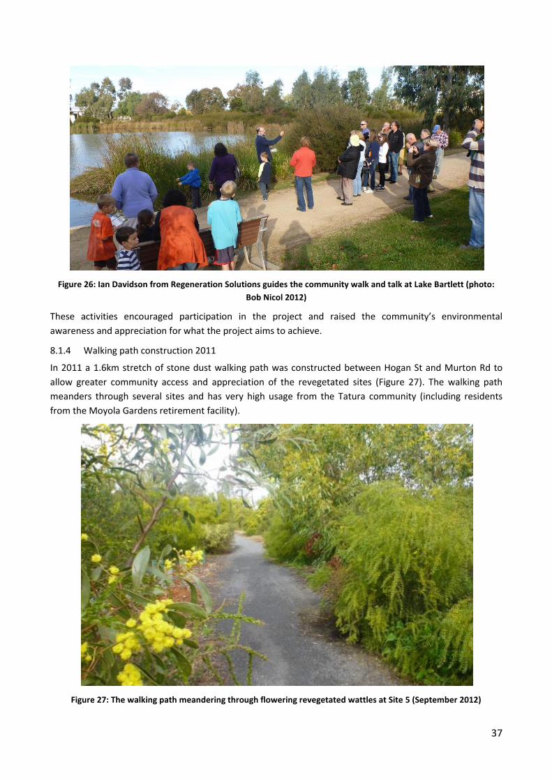
37
Figure 26: Ian Davidson from Regeneration Solutions guides the community walk and talk at Lake Bartlett (photo:
Bob Nicol 2012)
These activities encouraged participation in the project and raised the community’s environmental
awareness and appreciation for what the project aims to achieve.
8.1.4 Walking path construction 2011
In 2011 a 1.6km stretch of stone dust walking path was constructed between Hogan St and Murton Rd to
allow greater community access and appreciation of the revegetated sites (Figure 27). The walking path
meanders through several sites and has very high usage from the Tatura community (including residents
from the Moyola Gardens retirement facility).
Figure 27: The walking path meandering through flowering revegetated wattles at Site 5 (September 2012)

38
8.1.5 Shepparton Irrigation Region Landcare Partnership Award 2010
The Dhurringile and district Landcare Group received the Shepparton Irrigation Region Landcare Partnership
Award 2010 for the group’s involvement in the Crouching Emu Revegetation Project. The Award was great
recognition of the Landcare group’s vital contribution towards the Project and highlighted the importance of
working collaboratively with other groups or Councils to provide positive environmental or land
management outcomes.
8.1.6 Tatura Garden Club presentation 2012
A Committee member gave a presentation to the Tatura Garden Club about the project and provided
information on the use of indigenous plants in home gardens. It also allowed for community feedback about
the project and any suggestions, comments or concerns. These are
incorporated into the recommendations section (Chapter 10) of this
report.
8.1.7 Other school activities
World Environment Day with Sacred Heart School 2011 & 2012
The Committee assisted Sacred Heart School to conduct environmental
activities with their students. The Project supplied over 100 plants that
were planted by 40 children to create an indigenous native garden within
the school grounds in 2011. The Project also contributed additional
plants for students to enhance the garden further in 2012 (Figure 28).
The decision to have students create a native garden within their school
grounds demonstrates the Project’s influence on the participating
schools.
Nest box installation in Tatura Primary School in 2010
Three Committee members installed 6 nest boxes within the grounds of the Tatura Primary School. Ten
Grade 5/6 students were involved in numbering the nest boxes before installation then using a GPS receiver
recorded details including installation location, site name, tree type and the size of the nest box.
Walk and talk at Cussen Park with Sacred Heart School in 2012:
The Committee provided a guided tour through Cussen Park to Sacred Heart School Grade 2 students to
point out the wetland plants and the habitat provided to a
wide variety of wetland birds that inhabit the Park.
8.1.8 Crouching Emu signs
The project received funding from a Catchment Education
and Awareness Grant provided by the GBCMA to install
four signs to raise awareness of the Projects activities
(Figure 29). These signs identify Project partners and logos
and are situated at Sites 1, 3, 5 and 8.
8.1.9 Brochures
Two project brochures were designed and distributed in
2006 and 2009 that described the Project, its objectives,
progress and invited the community to participate.
Figure 28: The indigenous garden at Sacred Heart School that the project
helped create.
Figure 29: One of the four Crouching Emu signs along Dhurringile Road (Site 5)
39
A third and final brochure outlining the Project’s overall achievements was published in December 2012 via a
Shepparton Irrigation Region Catchment Education and Awareness Grant (Appendix VIII).
8.1.10 Dhurringile and District Landcare Calendar 2008
The project contributed funding towards the printing of the 2008 Dhurringile and District Landcare Calendar
that informed the community about regional environmental initiatives including information on the Project
and revegetation and gave contacts for more information. The calendar was available free to the community
and aimed to raise environmental awareness.
8.1.11 Caltrop campaign
The Project supported the Caltrop community education campaign to make residents and landowners aware
of this declared noxious weed and assisted with the Caltrop control program. A caltrop information brochure
was printed in 2008 and distributed to Tatura residents accompanied by media releases.
8.1.12 Media
Media were invited to all Project events such as National Tree Day, Schools Tree Day, the Lake Bartlett Walk,
and the Tidy Town finalist celebration. Both the Tatura Guardian and Tatura Area Community Bulletin have
provided wonderful support to the Project. All of these events were covered by the Tatura Guardian, many
appearing on the front page. The committee submitted fifteen articles on the project published in the Tatura
Area Community Bulletin. The project has also had two television stories aired on “Weeknights” on Southern
Cross Television promoting National Tree Day and in celebration of our Tidy Town Award finalist
announcement.
8.2 Accessing our success at achieving our community awareness and engagement activities
In 2009, community surveys were conducted to obtain an understanding of the attitudes of residents and
participant schools of the project. This process has been repeated in 2012 to once again measure the
project.
8.2.1 Community survey summary 2012
In April 2012, the Committee posted 76 surveys to adjoining properties of Dhurringile Rd and 21 (28%)
residents responded. Residents were asked about their knowledge about the Project, whether they have
been involved, how successful the Project has been and if they had any ideas for improvement. A copy of the
community survey is located in Appendix IX. A community survey was also conducted in 2009 with feedback
provided by 32 residents.
Four primary producers completed the survey and 57% of all respondents were over 60 years of age. The
average length of residency was 27 years, the shortest being 1.5 years. Only one respondent (the newest
resident) was unaware of the Project. 75% of respondents rated the Project as having high or very high
success for local landholder involvement and only one respondent rated success as below average (Table 2).
The majority of respondents also rated the Project as having high to very high success in involving the Tatura
community, revegetating Dhurringile Rd and beautifying the roadside.
The latest survey received higher ratings across all questions than the 2009 community survey. This may be
attributed to the ongoing community awareness through events such as the Tidy Town Awards, National
Tree Day and publicity in local newspapers for all events.
40
Table 2: Key 2012 community survey responses
Survey Question:
Has the Project
been successful in
involving local
landholders?
Has the Project
been successful in
involving the
Tatura community?
Has the Project
been successful in
revegetating
Dhurringile Road?
Has the Project
been successful in
beautifying
Dhurringile Road?
Percentage of responses that
rated the Project as having
high or very high success.
75% 75% 94% 89%
Respondents were invited to provide suggestions and many were received regarding ongoing maintenance
of the sites, drainage issues and weed control. There were many references to the use and enjoyment of the
paths and more than half the respondents (57%) would like to see the path networks continue to the north
of Hogan Street.
Suggestions for the future quotes included:
“More paths on the highway side of the roundabout. Beautifies and encourages exercise for
community. They also enjoy the environment and become future champions for further projects.”
“Extending the walking path south and north of Tatura (eg. to Toolamba Rushworth Rd and Pyke Rd).
There are always a lot of people using the walking track instead of walking on the bitumen.”
“Extend present path and vegetation toward Dhurringile and toward the Midland hwy. The present
path is a lovely walk.”
In this survey residents were asked if they were interested in planting indigenous native plants on their
properties and if interested in a bird survey. Some residents responded to this and as a result eight were
contacted to organise a site visit for plant species required and three for a bird survey. This further increased
the community’s awareness of and involvement in the Project and expanded the environmental corridor to
private land.
8.2.2 School survey summary 2012
Tatura Primary Schools, Bethel Christian College, Sacred Heart School and Tatura Primary School and
Mooroopna Secondary College have been major Project contributors over the last 6 years. In April 2012 the
Committee posted a school surveys to each school to provide feedback on the schools experiences with the
Project and how it benefited their students. A copy of the school survey is located in Appendix X. A school
survey was also conducted in 2009 and again, all schools were very enthusiastic about the project and their
student’s experience of it.
The teachers enjoyed the community involvement and well organised sessions, seeing the children enjoy
themselves and participate enthusiastically. All schools commented they would like to see activities such as
these continued. When asked what the students enjoyed most, teachers replied that students enjoyed the
hands on practical activities, interacting with other community members, and making a contribution to the
community.
All schools rated the Project as successful or highly successful for the following:
o Beautifying the town entrance
o Providing a wildlife corridor
o Engaging school children in environmental activities
o Increasing the children’s awareness of environmental care.
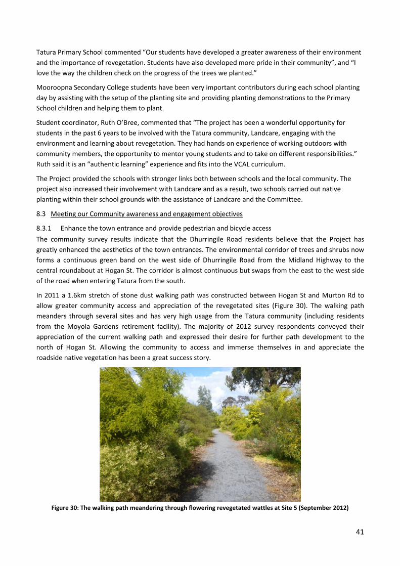
41
Tatura Primary School commented “Our students have developed a greater awareness of their environment
and the importance of revegetation. Students have also developed more pride in their community”, and “I
love the way the children check on the progress of the trees we planted.”
Mooroopna Secondary College students have been very important contributors during each school planting
day by assisting with the setup of the planting site and providing planting demonstrations to the Primary
School children and helping them to plant.
Student coordinator, Ruth O’Bree, commented that “The project has been a wonderful opportunity for
students in the past 6 years to be involved with the Tatura community, Landcare, engaging with the
environment and learning about revegetation. They had hands on experience of working outdoors with
community members, the opportunity to mentor young students and to take on different responsibilities.”
Ruth said it is an “authentic learning” experience and fits into the VCAL curriculum.
The Project provided the schools with stronger links both between schools and the local community. The
project also increased their involvement with Landcare and as a result, two schools carried out native
planting within their school grounds with the assistance of Landcare and the Committee.
8.3 Meeting our Community awareness and engagement objectives
8.3.1 Enhance the town entrance and provide pedestrian and bicycle access
The community survey results indicate that the Dhurringile Road residents believe that the Project has
greatly enhanced the aesthetics of the town entrances. The environmental corridor of trees and shrubs now
forms a continuous green band on the west side of Dhurringile Road from the Midland Highway to the
central roundabout at Hogan St. The corridor is almost continuous but swaps from the east to the west side
of the road when entering Tatura from the south.
In 2011 a 1.6km stretch of stone dust walking path was constructed between Hogan St and Murton Rd to
allow greater community access and appreciation of the revegetated sites (Figure 30). The walking path
meanders through several sites and has very high usage from the Tatura community (including residents
from the Moyola Gardens retirement facility). The majority of 2012 survey respondents conveyed their
appreciation of the current walking path and expressed their desire for further path development to the
north of Hogan St. Allowing the community to access and immerse themselves in and appreciate the
roadside native vegetation has been a great success story.
Figure 30: The walking path meandering through flowering revegetated wattles at Site 5 (September 2012)

42
8.3.2 Increased community awareness and education, especially in regard to indigenous plants and weed management
Over the last seven years the Project has published three Project activity brochures, placed four Crouching
Emu signs along Dhurringile Rd, supported the Caltrop control campaign, assisted in the production of a local
Landcare calendar and has had extensive media coverage (refer to 8.1.12). The walk and talk event at Lake
Bartlett explained the wetland habitat, ecology and outlined the associated environmental benefits to the
Tatura community and was linked with the objectives of the Project. A “Gardening with local native plants”
and a caltrop control brochure have been distributed throughout Tatura. This report is the fourth Project
Report available for community access that provides information on the Project and its objectives.
The 2012 community survey found that 95% of adjacent residents that responded were aware of the Project
with 45% of respondents stating that they had some understanding and 50% stating that they had a good
understanding of the Project. Adjacent residents responded favourably in the 2012 community survey to
conducting native flora and fauna activities on their properties, including eight who accepted indigenous
native plants to plant on their own properties or property frontages and three who requested bird surveying
on their property.
All participating schools rated the Project as successful or highly successful for engaging school children in
environmental activities and increasing the children’s awareness of environmental care. The project was
ideal to involve and promote environmental activities to school children and the community.
43
9 Key project learning’s
The following points are a summary of our key learning’s across the seven years of the project. Many
successes and the occasional error were experienced along the way.
9.1 Revegetation activities
Ground preparation needs to be performed well in advance. Sites should be shallow ripped and
rotary hoed to allow moisture into the soil and for weed management purposes.
Perform plantings earlier in the planting season. The most successful revegetation sites were planted
before August.
Leave a space for walking paths amongst plantings. From a visual and experiential aspect, a gentle
meandering path is the most engaging where possible. Leave visual breaks amongst plantings using
groundcovers and low shrubs at sites within the town boundary or at sites with walking paths.
Use 10 or more indigenous plant shrub or groundcovers species per site to gain the maximum native
understorey score during site assessments.
The most successful sites have been planted with spacing closer together than recommended by
revegetation guides. When the shrubs were densely revegetated, non-woody weed species were
outcompeted after several years of growth by the shrubs, and native grasses such as Spear Grass
(Austrostipa spp.) and Wallaby Grass (Austrodanthonia spp.) would return to the site.
Careful thought must be given to the groundcover species revegetated at roadside sites. Although it
is important to re-establish native groundcovers in the landscape, many groundcover species are
easily outcompeted by weeds and survival rates have been low. The most competitive groundcover
species planted have been native grasses, flax lillies and saltbush species.
Care must be taken in hiring spraying contractors to ensure that they have some knowledge in native
plant identification and are very careful not to poison any native plants.
Post planting watering was essential to ensure the survival of planted vegetation. This was especially
the case during poor environmental conditions. Most of the planting years occurred during the
prolonged drought years so sites were watered over summer when necessary.
9.2 Community engagement
Engage adjacent landowners and the community early and throughout the project using different
approaches, incentives or opportunities. Sharing the aims with the local community definitely
contributes to the success of the project and increases environmental awareness.
Community engagement should include incentives to plant on their own properties to broaden the
corridor and increase understanding of native vegetation.
Project evaluation through assessments and surveys has been an important aspect of this project. It
is a quantitative way of measuring project success which can be reported back to project
stakeholders or partners and used to evaluate methods. A mid-term evaluation allows time to
review methods if results are unfavourable.
Engaging local schools in local environmental projects is invaluable for both assistance in achieving
the revegetation and for its educational and environmental awareness of our future land carers. It
also develops school and community links.
Having the Mooroopna Secondary School students help the Primary School students to plant worked
really well.

44
The walking path has increased the community’s awareness and appreciation of the Project and the
native vegetation planted. Planting over 13,000 plants has been a great achievement but the walking
path has greatly increased the community’s enjoyment of the native vegetation.
Revegetation success was always highest where there was invaluable adjacent landholder support
via additional watering and weeding provided in the crucial first year.
45
10 Management recommendations
The following activities have been outlined to ensure the Crouching Emu revegetation sites continue to be
maintained into the future.
10.1 Site management recommendations
10.1.1 Weed management
It is very important that best practice weed control continues at Site 1 (north of Hogan St, opposite the
Generations Church) to prevent weed species from outcompeting the significant native species present but
any weed control at this site requires native vegetation specialist supervision.
Non-woody weeds
All sites require monitoring for weed management, particularly where the plantings are young and small.
Until these plants become established they will be threatened by weeds smothering and outcompeting them
for water and nutrients. Sites 3, 5, 12, 13 and 14 have plantings less than two years old.
Site 3, 5 and 14 and near the gas substation require vigilant control of Caltrop and Paterson’s curse.
Site 5 needs monitoring for Chilean Needle Grass particularly in the grassy area (Site 5b).
Site 5 requires mulching and spot weed application to keep weeds at bay until the shrubs and groundcovers
become established.
Site 7 and 9 has high regeneration of many native seedlings so care needs to be taken during weed control.
Only hand pull or spot spray at these sites.
Woody weeds
All woody weeds noted during the site assessments have been removed for the finish of the project.
Many woody weeds will unfortunately reappear due to seed dispersal from weeds on adjacent land so
continued monitoring will be important. The main species were Desert Ash and Briar Rose and a variety of
other species (Cotoneaster, Privet, Olive and Boxthorn) in Site 1.
10.1.2 Removal of tree guards
Remove tree guards as plants become established from sites planted within the last two years (Sites 3, 5, 12,
13 & 14).
10.1.3 Watering
Continue summer watering at Site 3, 14 and 5 over the summer of 2012/13 while plants are in the first year.
10.1.4 Pruning and removal of dead plants within town boundary
Within the town boundary it is important to keep aesthetic appeal to plantings particularly where there is
path access. This involves pruning of shrubs as they mature and encroach upon the path and removal of
dead shrubs annually. As dead plants are removed replant with groundcovers or low growing shrubs to allow
visual breaks in the plant corridor for pedestrians. This would apply to Site 5, 7 and 9.
10.1.5 Access drainage
Site 13 has had particular problems with drainage. This needs accessing including checking for blockages in
the culvert under the road. Large rain events or irrigation leakages could be detrimental to the site and
result in the drowning of plants.
46
10.1.6 Walking path safety concerns at road and train crossings
The community has raised safety concerns relating to the gutter where the walking path crosses the road at
Dhurringile Rd and O’Reilly Rd. Both roads have heavy local traffic and are used by trucks coming to and
from local industries. It is recommended that an easy ramp be installed for prams, the elderly and children
on bikes to negate the gutter.
Safety concerns were also raised regarding the lack of path at the train line crossing. The path currently leads
users onto the road at the crossing and commences again on the other side. It is recommended that the path
be installed between the tracks so pedestrians, prams and cyclists do not need to walk on the road.
10.1.7 Significant site management
Site 1 is the most significant site along Dhurringile Rd due to its species richness and the significant
indigenous species that are only situated at this location. This site needs careful management to keep
disturbance to a minimum. It is critical to have good woody weed management to prevent weeds from
outcompeting the local species. Weed removal needs to be performed by a native vegetation specialist in
groundcover species to ensure no damage to significant species.
Significant roadside vegetation signage needs to be installed at each end of the site.
10.2 Recommendations for future activities
Recommendations from the community for further enhancement of Dhurringile Rd have arisen from the
community survey and talking in person with landowners and Tatura residents. Requests included more
walking paths, seats and continued weed management.
More walking paths
Extension of the walking paths to the North and South of Tatura and providing links to other walking/bike
path networks in Tatura was the most common request or suggestion by the community for the future. The
construction of a walking path to the north of Hogan St would need to be located along the edge of the
plantings, not through them. The path at Site 1 would need to be carefully placed to ensure little disturbance
occurs to the remnant vegetation. Any activities at this site need to be carefully managed to ensure that
disturbance is kept to an absolute minimum. Council’s Sustainability and Environment Team will need to be
involved with any activities at this site.
Seating
Community survey respondents also requested the installation of seats at a number of places along the path
for walkers to rest or be able to sit and enjoy the ambiance of the plantings. Site 5 in particular would be a
great location for seating.
Horse riding and dog droppings
Community members have raised concerns about horse riders digging up the gravel path and dog droppings
spoiling the walk (particularly at Site 7 and Site 9). The installation of a dog dropping bag dispenser may
encourage cleanliness of the area. Prevention of horse riding activities would help reduce path maintenance
and increase the paths appeal to walkers.
Weed management
It would be very beneficial to undertake an information and awareness campaign about problematic woody
weed species (in particular garden escapees) and the impact they are having on our environment and
revegetated sites.

47
11 In closing
The Crouching Emu Revegetation Project was a highly successful, Tatura community driven project that
concluded at the end of 2012. The Project’s mission to establish an environmental corridor containing
indigenous species along Dhurringile Road, Tatura was achieved. The Project spent the last seven years
protecting and enhancing the remnant native vegetation present along Dhurringile Road through extensive
revegetation activities. A strong emphasis was placed on achieving these objectives via a committed
community engagement process to increase environmental awareness.
Although the Committee is saddened that the Project has come to an end, all members are filled with a deep
sense of pride and satisfaction that the Project has been a resounding success. It is now time to handover
the management of these revegetated sites to Greater Shepparton City Council and the Dhurringile and
District Landcare Group and share our knowledge and experiences with others to ensure other revegetation
projects can learn from our achievements.
The two major factors that attributed to Project successes have been the establishment of strong
partnerships and relationships between State and local government, community groups and the community
themselves; and placing a strong emphasis on community engagement and community participation.
The Committee would like to thank the following organisations for their contribution and commitment to
the Crouching Emu Revegetation Project:
Greater Shepparton City Council
Goulburn Murray Landcare Network (GMLN)
Dhurringile and District Local Area Plan/Landcare Group
The Department of Primary Industries (DPI)
Tatura Revitalisation Committee
Generations Church ACC, Tatura
and Transition Tatura.
The Committee would like also like to thank the following major Project supporters for their tireless efforts
over the last seven years:
The Goulburn Broken Catchment Management Authority
Tatura Primary School
Sacred Heart School
Bethel Christian College
Mooroopna Secondary College
The Mission Australia National Green Jobs Corps work crew
The Tatura Guardian and the Tatura Community Area Bulletin
and the Tatura community, particularly the residents and landholders along Dhurringile Road.
The revegetated native vegetation along Dhurringile Road, Tatura will be the long lasting legacy of the
Crouching Emu Revegetation Project that will be enjoyed by many future generations of the Tatura
community.
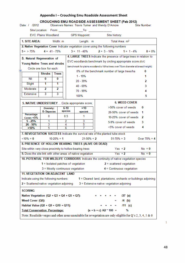
48
Appendix I – Crouching Emu Roadside Assessment Sheet
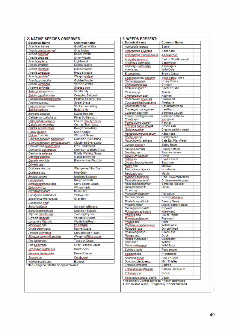
49

50
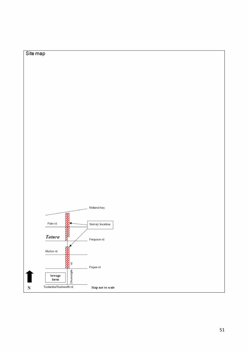
51
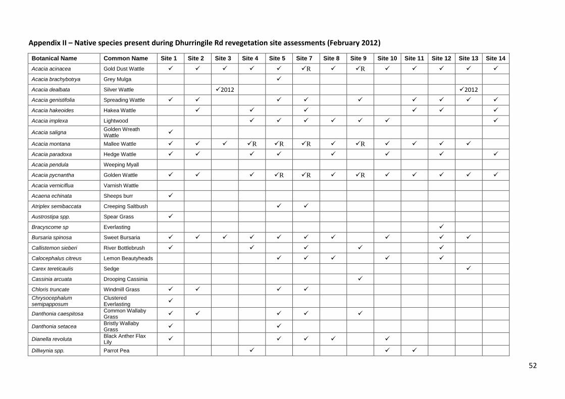
52
Appendix II – Native species present during Dhurringile Rd revegetation site assessments (February 2012)
Botanical Name Common Name Site 1 Site 2 Site 3 Site 4 Site 5 Site 7 Site 8 Site 9 Site 10 Site 11 Site 12 Site 13 Site 14
Acacia acinacea Gold Dust Wattle R R
Acacia brachybotrya Grey Mulga
Acacia dealbata Silver Wattle
2012
2012
Acacia genistifolia Spreading Wattle
Acacia hakeoides Hakea Wattle
Acacia implexa Lightwood
Acacia saligna Golden Wreath Wattle
Acacia montana Mallee Wattle R R R R
Acacia paradoxa Hedge Wattle
Acacia pendula Weeping Myall
Acacia pycnantha Golden Wattle
R R R
Acacia verniciflua Varnish Wattle
Acaena echinata Sheeps burr
Atriplex semibaccata Creeping Saltbush
Austrostipa spp. Spear Grass
Bracyscome sp Everlasting
Bursaria spinosa Sweet Bursaria
Callistemon sieberi River Bottlebrush
Calocephalus citreus Lemon Beautyheads
Carex tereticaulis Sedge
Cassinia arcuata Drooping Cassinia
Chloris truncate Windmill Grass
Chrysocephalum semipapposum
Clustered Everlasting
Danthonia caespitosa
Common Wallaby Grass
Danthonia setacea
Bristly Wallaby Grass
Dianella revoluta
Black Anther Flax Lily
Dillwynia spp. Parrot Pea
53
Botanical Name Common Name Site 1 Site 2 Site 3 Site 4 Site 5 Site 7 Site 8 Site 9 Site 10 Site 11 Site 12 Site 13 Site 14
Dillwynia cinerescens Grey Parrot Pea
Dodonea viscosa
Wedge-leaf Hop Bush
R
R
Dodenea spp. Hop Bush
R
Einadia nutans Nodding Saltbush
Enchylaena Ruby Saltbush
Enteropogan acicilaris Curly Spider Grass
Epilobium spp. Willow Herb
Eucalyptus microcarpa Grey Box
Eucalyptus melliodora Yellow Box
Eutaxia microphylla Common Eutaxia
Glycine clandestina Twining Glycine
Glycine tabacina Variable Glycine
Hardenbergia sp Happy wanderer
Juncus sp Native Rush
Lachnagrostis sp Blown grass
Leptospernum obovatum River Tea-tree
2012
2012
Lomandra filiformis Wattle Mat Rush
Melaleuca lanceolata Black Paperbark
2012
2012
Melaleuca spp. Paperbark
Muehlenbeckia florulenta Tangled Lignum
2012
2012
Oxalis perennans Native Oxalis
Panicum sp Panic
Pittosporum phylliraeoides
Weeping Pittosporum
Poa labillardieri Tussock Grass
Pycnosorus globulus Drumsticks
Rumex sp Native Dock
Senna artemesoides Desert Cassia
R indicates there were young plants present as a result of natural regeneration.
2012 indicates this species was planted in 2012 after the roadside survey was completed.
54
Appendix III – Weed species present during Dhurringile Rd revegetation site assessments (February 2012)
Botanical Name Common Name Site 1 Site 2 Site 3 Site 4 Site 5 Site 7 Site 8 Site 9 Site 10 Site 11 Site 12 Site 13 Site 14
Acetosella vulgaris Sorrel
Alternanthera spp. Joyweed
Artotheca calendula Capeweed
Asparagus officinalis Asparagus
Avena spp. Wild Oats
Bromus spp. Brome Grass
Cichorium intybus Chicory
Cirsium vulgare^ Spear Thistle
Chenopodium spp. Fat Hen
Conyza albida/bonarienis Fleabane
Cynosurus echinatus Rough dogs tail
Cynodon dactylon Bermuda Couch
Cyperus sp. Umbrella Sedge
Echinochloa spp Barnyard grass
Dactylis glomerata Cocksfoot
Fraxinus angustifolia # Desert Ash
Gastridium phleoides Nitgrass
Heliotropium europaeum Heliotrope
Hordeum spp. Barley Weed
Hypochoeris radicata Cats Ear/Flat Weed
Lactuca serriola Prickly Lettuce
Lepidium spp. Peppercresses
Ligustrum lucidum Privet
Lolium sp Rye Grasses
Lycium ferocissimum+ Boxthorn
Malva spp. Mallow
Marrubium vulgare+ Horehound
Medicago spp. Medic
55
Botanical Name Common Name Site 1 Site 2 Site 3 Site 4 Site 5 Site 7 Site 8 Site 9 Site 10 Site 11 Site 12 Site 13 Site 14
Modiola caroliniana Red Flowered Mallow
Nassella neesiana^@ Chilean needle grass ***
Panicum sp Panic grass
Paspalum dilatatum Paspalum
Picris echioides Bristly oxtongue
Phalaris aquatica # Canary Grass
Phalaris minor Lesser canary grass
Plantago lanceolata Ribwort
Polygonum aviculare Wire weed
Portulaca oleracea Pig weed
Ranunculas sp Buttercup
Romulea rosa Onion Weed
Rosa rubiginosa+ Briar Rose
Rumex spp. Dock
Rubus fruticosus+ Blackberry
Salix spp.^ Willow
Solanum spp. Nightshade
Sonchus asper Sow Thistles
Sonchus oleraceeus Milk Thistles
Tribulus terrestris+ Caltrop
Trifolium augustifolium Narrow leaf clover
Trifolium spp. Clover
Vicia sativa subsp. Sativa Vetch
Xanthium spinosum Bathurst Burr
~ Regionally Prohibited Weed, + Regionally Controlled Weed, @ Weed of National Significance, ^ Restricted Weed, # Undeclared weed of concern
*** Previously occurred at this site
56
Appendix IV – Fauna recorded during Roadside survey (8 March) and on three adjacent
properties (31 August).
Common name Scientific name 8th March 2012 - Roadside survey
31st August 2012 - Three private properties
Australian Magpie Gymnorhina tibicen
Australian Raven Corvus coronoides
Australian White Ibis Threskiornis molucca
Australian Wood Duck Chenonetta jubata
Black-faced Cuckoo-shrike Coracina novaehollandiae
Blue-faced Honeyeater Entomyzon cyanotis
Brown Goshawk Accipter fasciatus
Brown falcon Falco berigora
*Common Blackbird Turdus merula
*Common Myna Acridotheres tristis
*Common Starling Sturnus vulgaris
Crested Pigeon Ocyphaps lophotes
Eastern Rosella Platycercus eximius
*European Goldfinch Carduelis carduelis
Galah Eolophus roseicapillus
Grey Shrike Thrush Colluricincla harmonica
*House Sparrow Passer domesticus
Little Lorikeet Glossopsitta pusilla
Magpie-lark Grallina cyanoleuca
Musk Lorikeet Glossopsitta concinna
New Holland Honeyeater Phylidonyris novaehollandiae
Noisy Miner Manorina melanocephala
Pied Butcherbird Cracticus nigrogularis
Red Browed Firetail Neochmia temporalis
Red Wattlebird Anthochaera carunculata
Red-rumped Parrot Psephotus haematonotus
Silvereye Zosterops lateralis
Spotted Pardalote Pardalotus punctatus
*Spotted Turtle-Dove Streptopelia chinensis
Striated Pardalote Pardalotus striatus
Sulphur-crested Cockatoo Cacatua galerita
Superb Fairy-wren Malurus cyaneus
Wedge-tailed Eagle Aquila audax
Welcome Swallow Hirundo neoxena
White-breasted Woodswallow
Artamus leucorynchus
White-plumed Honeyeater Lichenostomus penicillatus
Willie Wagtail Rhipidura leucophrys
Total number of birds observed 31 24 Frogs
Common Froglet Crinia signifera
Pobblebonk Frog Limnodynastes durmerilii
Spotted Grass Frog Limnodyastes tasmaniensis
*exotic species
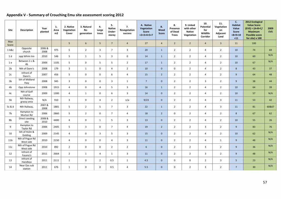
57
Appendix V - Summary of Crouching Emu site assessment scoring 2012
Site Description Year
planted
1. Area m2
2. Native Vegetation
Cover
3. Natural Re-
generation
4. Large trees
5. Native Under-storey
7. Revegetation
success
A. Native Vegetation
Score =2+3+4+5+7
B. Weed Score
8. Presence of Dead
Trees
9. Linked with other
Native Vegetation
10. Potential
for Wildlife Corridor
11. Vegetation
on Adjacent
Land
C. Habitat Value Score
=8+9+10+11
2012 Ecological Value Score
(EVS) = (A+B+C/ Maximum
Possible score for site) x 100
2009 EVS
Max Score
5 6 5 7 4 27 4 2 2 4 3 11 100
1 b&c Opposite church
2006 & 2008
975 5 2 3 7 3 20 1 2 2 4 2 10 74 69
1 d opp Whim Inn 2010 546 5 1 5 3 0 14 1 2 2 4 2 10 60 N/A
1 e Between 1 c &
4b 2009 1105 5 0 5 5 2 17 1 2 2 4 2 10 67 N/A
2b Nth of Dann's 2008 179 3 1 0 4 2 10 0 0 2 4 2 8 43 37
2c Infront of
Dann's 2007 456 5 0 0 6 4 15 2 2 2 4 2 9 64 48
3b Sth of Midland
Hwy 2008 945 3 0 0 3 1 7 0 2 2 3 2 9 38 44
4b Opp Johnstone 2008 1915 4 0 4 5 3 16 1 2 2 4 2 10 64 39
4c Nth of Golf
course 2009 1300 4 1 0 6 3 14 0 2 2 4 2 10 57 N/A
5b Nth Railway, grassy area
N/A 910 3 0 4 2 n/a 9/23 0 2 2 4 3 11 53 42
5c & d Nth Railway, 2007 &
2008 1881 5 2 5 7 3 22 1 2 2 4 3 11 81 60&67
7b Hampton to Murton Rd
2006 2860 5 2 0 7 4 18 2 0 2 4 2 8 67 62
8b Direct seeding
site 2008 &
2010 4400 4 0 1 5 3 13 0 2 2 4 2 10 55 26
9 Hampton to
Taylor Rd 2006 2405 5 3 0 7 4 19 2 2 2 3 2 9 83 76
10 Sth of Holm &
Golding 2009 2145 4 0 3 5 3 15 0 2 2 4 2 10 62 N/A
11b Nth of Pogue Rd
West side 2010 2150 4 0 0 4 3 11 0 2 2 4 1 9 48 N/A
11c Nth of Pogue Rd
West side 2010 892 2 0 0 2 2 6 0 2 2 3 2 9 36 N/A
12 Infront of Fasano's
2011 2664 2 1 4 1 3 11 0 2 2 3 2 9 48 N/A
13 Infront of Handleys
2011 2111 1 0 2 0.5 1 4.5 0 0 0 2 3 5 23 N/A
14 Near Gas sub
station 2011 676 1 0 0 0.5 4 5.5 0 0 2 3 2 7 30 N/A
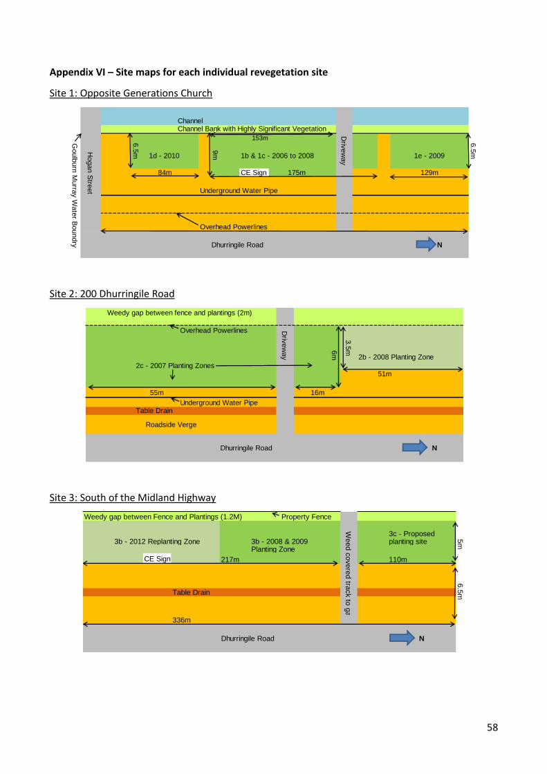
58
Appendix VI – Site maps for each individual revegetation site
Site 1: Opposite Generations Church
Site 2: 200 Dhurringile Road
Site 3: South of the Midland Highway
ChannelChannel Bank with Highly Significant Vegetation
153m
1d - 2010 1b & 1c - 2006 to 2008
CE Sign 175m
Underground Water Pipe
Overhead Powerlines
Dhurringile Road N
9m
6.5
mHogan S
treet
Goulb
urn
Murra
y W
ate
r Boundry
Driv
ew
ay
84m
1e - 2009
6.5
m
129m
Weedy gap between fence and plantings (2m)
Overhead Powerlines
6m
2b - 2008 Planting Zone
2c - 2007 Planting Zones51m
55m 16m
Underground Water PipeTable Drain
Dhurringile Road N
Driv
ew
ay
3.5
m
Roadside Verge
Weedy gap between Fence and Plantings (1.2M) Property Fence
3c - Proposed3b - 2012 Replanting Zone 3b - 2008 & 2009 planting site
Planting Zone
CE Sign 217m 110m
Table Drain
336m
Dhurringile Road N
Weed c
overe
d tra
ck to
gate
5m
6.5
m

59
Site 4: Opposite Johnstone Rd
Site 5: North of the railway line
Site 7: Between Hampton and Murton Rds
Channel Decomissioned Channel
Channel Bank
4b - 2008 Planting Zones ● 4c - 2009 Planting Zone
340m 30m 260m
Underground Water Pipe
Table Drain
Overhead Powerlines
383m
Dhurringile Road N
5m
Gro
und W
ate
r Observ
atio
n B
ore
Tra
ck
9m
GM Water marker Property Fence
Weedy gap between property fence and plantings
5b - Native Grass Zone
Path
70m 101m
5a - Roadside Verge and Table Drain
Table Drain
65m 174m
Dhurringile Road N
Site starts from
round post
11m
12m
14m
Driv
ew
ay
5m
CE Sign
Property Fence
7b - 2006 Planting Zones
Path
Underground Waterpipe
230m
Table Drain
Underground Telstra Assets
29m
250m
Dhurringile Road N
Overhead Powerlines
8m
6.5
m
Murto
n R
oad
13m
Ham
pto
n R
oad
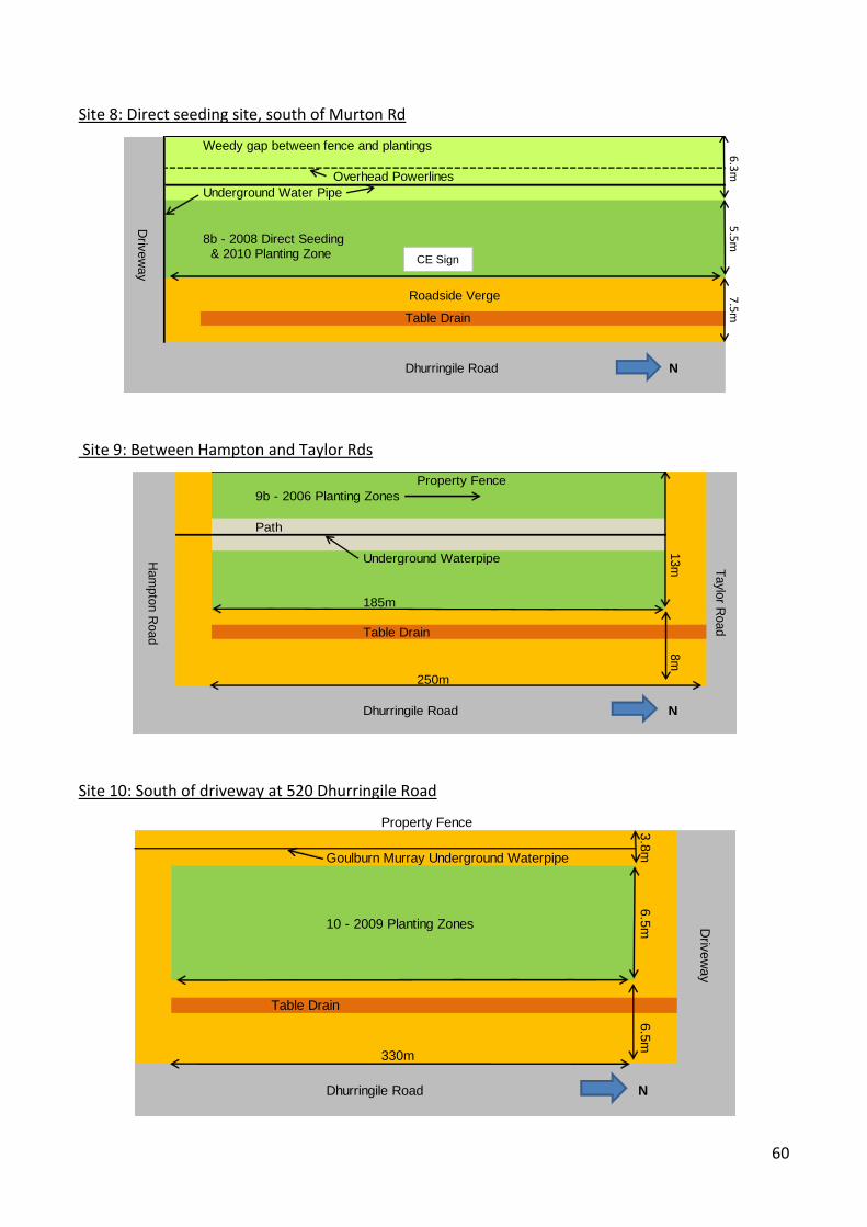
60
Site 8: Direct seeding site, south of Murton Rd
Site 9: Between Hampton and Taylor Rds
Site 10: South of driveway at 520 Dhurringile Road
Weedy gap between fence and plantings
Overhead Powerlines
Underground Water Pipe
8b - 2008 Direct Seeding & 2010 Planting Zone
Table Drain
Dhurringile Road N
6.3m
Driv
ew
ay
Roadside Verge 7.5m5.5m
CE Sign
Property Fence
9b - 2006 Planting Zones
Path
Underground Waterpipe
185m
Table Drain
250m
Dhurringile Road NH
am
pto
n R
oad
13m T
aylo
r Road
8m
Property Fence
Goulburn Murray Underground Waterpipe
10 - 2009 Planting Zones
Table Drain
330m
Dhurringile Road N
Driv
ew
ay
3.8
m6.5
m6.5
m
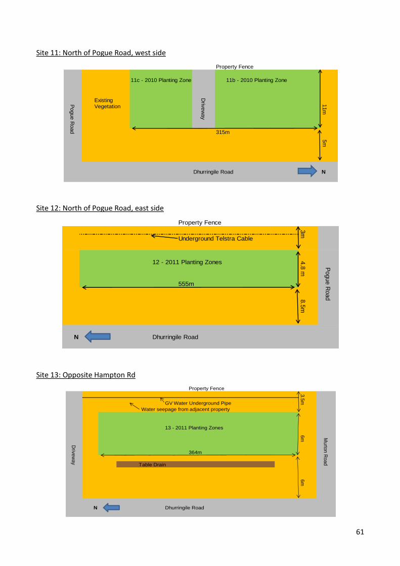
61
Site 11: North of Pogue Road, west side
Site 12: North of Pogue Road, east side
Site 13: Opposite Hampton Rd
Property Fence
11c - 2010 Planting Zone 11b - 2010 Planting Zone
ExistingVegetation
315m
Dhurringile Road N
Driv
ew
ay
Pogue R
oad
11m
5m
Property Fence
Underground Telstra Cable
12 - 2011 Planting Zones
555m
N Dhurringile Road
3m
Pogue R
oad
4.8
m8.5
m
Property Fence
GV Water Underground Pipe
Water seepage from adjacent property
13 - 2011 Planting Zones
364m
Table Drain
N Dhurringile Road
3.5
m6m
Murto
n R
oad
6m
Drive
way
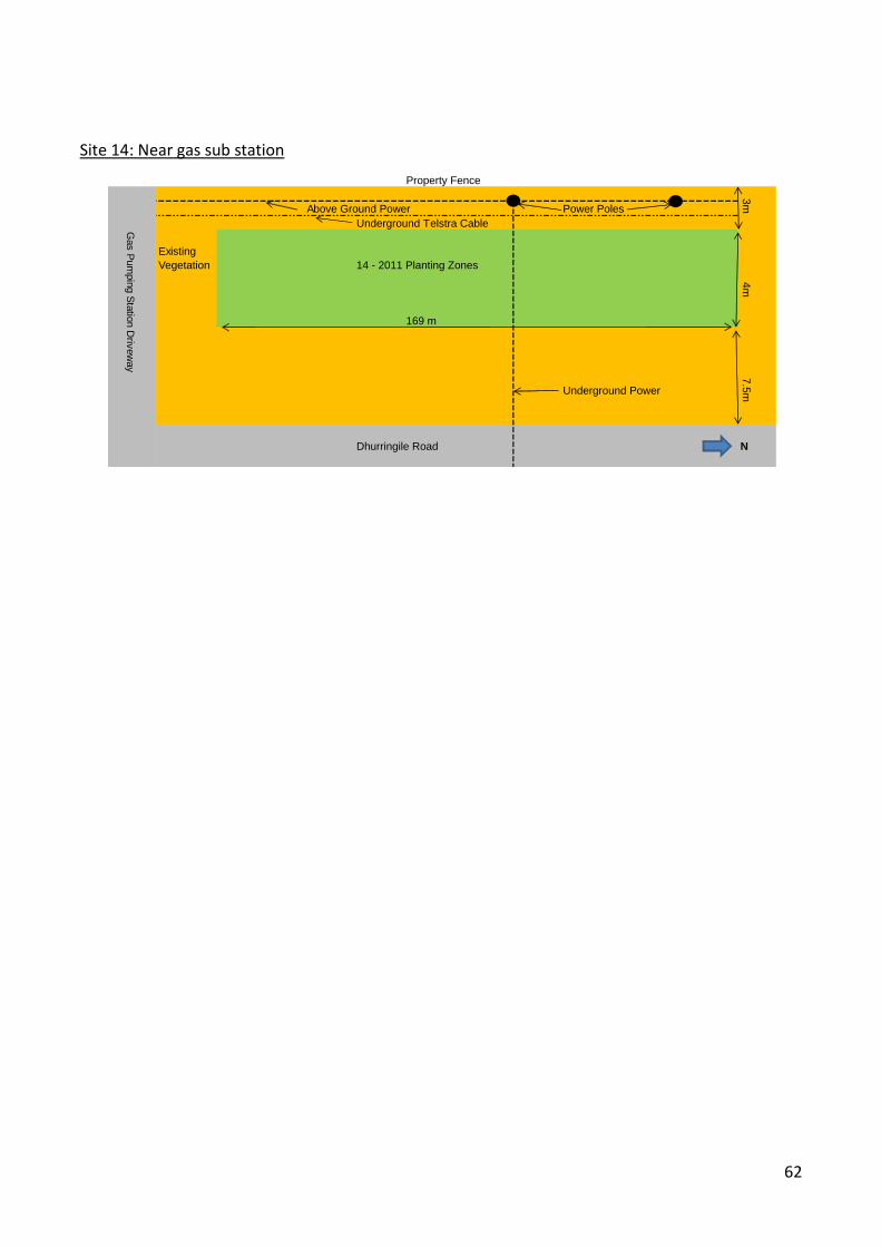
62
Site 14: Near gas sub station
Property Fence
Above Ground Power Power Poles
Underground Telstra Cable
Existing
Vegetation 14 - 2011 Planting Zones
169 m
Underground Power
Dhurringile Road N
3m
7.5
m4m
Gas P
um
pin
g S
tatio
n D
rivew
ay
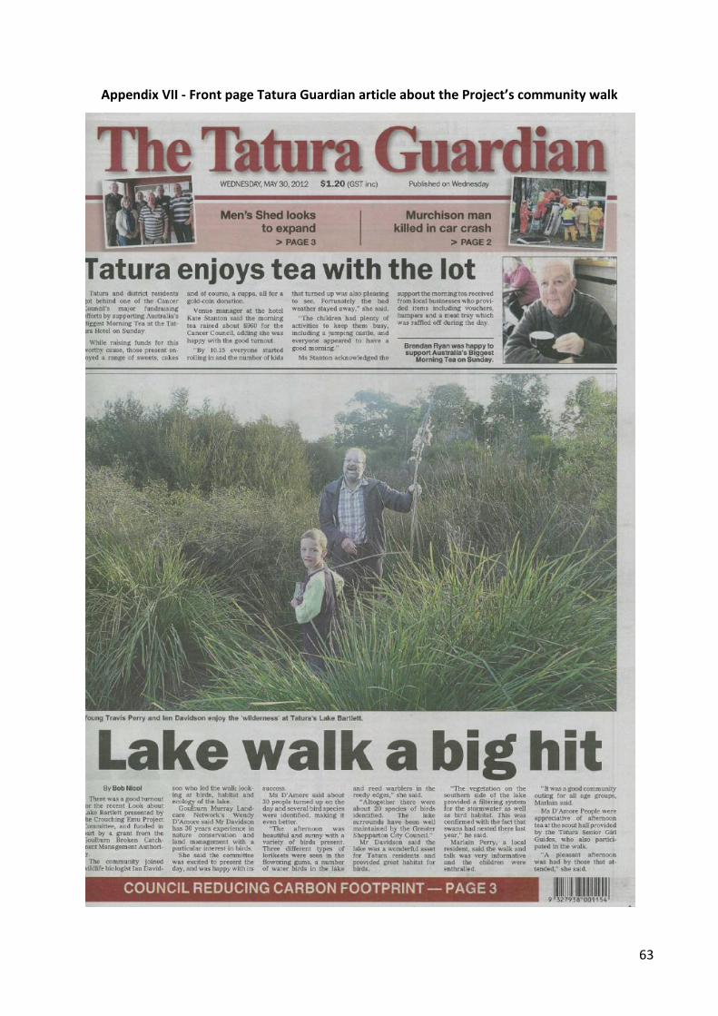
63
Appendix VII - Front page Tatura Guardian article about the Project’s community walk
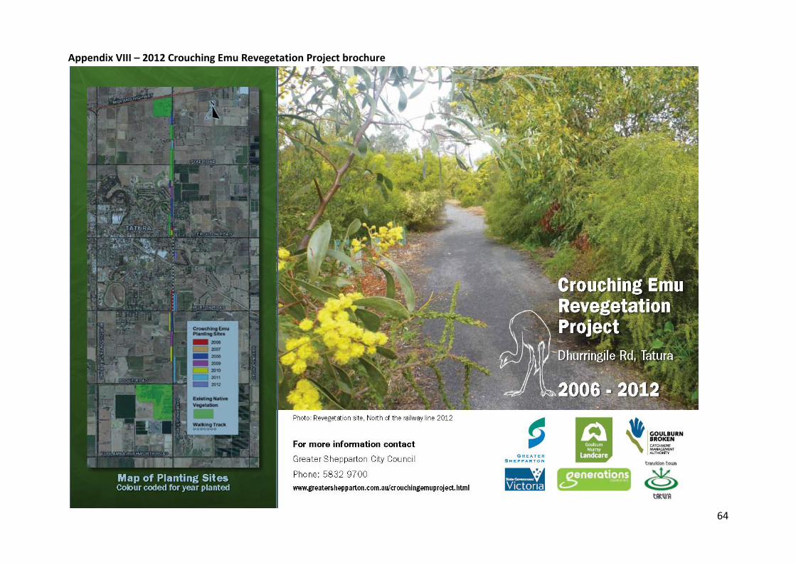
64
Appendix VIII – 2012 Crouching Emu Revegetation Project brochure
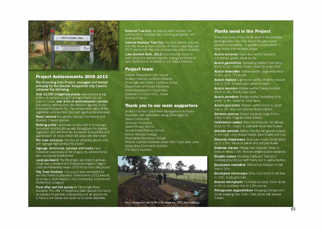
65

66
Appendix IX – 2012 Community Survey

67

68
Appendix X – 2012 School Survey