The CRM Cycle 03 - Participatory Coastal...revenue sources Annual program preparation and budgeting...
27
1 Issue identification and baseline assessment CRM plan preparation and adoption Action plan and project implementation Monitoring and evaluation Information management, education and outreach Issue identification and baseline assessment CRM plan preparation and adoption Action plan and project implementation Local legislation Coastal law enforcement Regulation External revenue sources Annual program preparation and budgeting Revenue generation Monitoring and evaluation Information management, education and outreach The CRM Cycle
Transcript of The CRM Cycle 03 - Participatory Coastal...revenue sources Annual program preparation and budgeting...

1
Issue identificationand baseline assessment
CRM planpreparation
and adoption
Action plan and project
implementation
Local legislation
Coastal lawenforcement
Regulation
Externalrevenuesources
Annual programpreparation andbudgeting
Revenuegeneration
Monitoring and evaluation
Information management, education andoutreach
Issue identificationand baseline assessment
CRM planpreparation
and adoption
Action plan and project
implementation
Local legislation
Coastal lawenforcement
Regulation
Local legislation
Coastal lawenforcement
Regulation
Externalrevenuesources
Externalrevenuesources
Annual programpreparation andbudgeting
Annual programpreparation andbudgeting
RevenuegenerationRevenuegeneration
Monitoring and evaluation
Information management, education andoutreach
The CRM Cycle

2
Issue identificationand baseline assessment
CRM planpreparation
and adoption
Action plan and project
implementation
Local legislation
Coastal lawenforcement
Regulation
Externalrevenuesources
Annual programpreparation andbudgeting
Revenuegeneration
Monitoring and evaluation
Information management, education andoutreach
Issue identificationand baseline assessment
CRM planpreparation
and adoption
Action plan and project
implementation
Local legislation
Coastal lawenforcement
Regulation
Local legislation
Coastal lawenforcement
Regulation
Externalrevenuesources
Externalrevenuesources
Annual programpreparation andbudgeting
Annual programpreparation andbudgeting
RevenuegenerationRevenuegeneration
Monitoring and evaluation
Information management, education andoutreach
The CRM Cycle
Commitment and Willingness of the LGU and the Communities?Data gathering, consolidation and analysis? Community consultations?Drafting of plan? Legislation? Implementation, monitoring and evaluation
The Planning Process

3
Data Gathering through PCRA, identification of:
Resources - elements in the environment used by individualsor society to satisfy particular needs
Resource-Uses
- ways of utilizing the elements in the specificarea and time
Resource-Users
- the stakeholders in Coastal Resources Management- individuals or group of individuals who tap various elements in the environment to satisfyneeds and wants

4
Objectives:Objectives:
1.1. Provide the rationale for PCRA in the context of Provide the rationale for PCRA in the context of good governance in CRMgood governance in CRM
2.2. Familiarize participants with some participatory Familiarize participants with some participatory methods and apply these in actual coastal habitat, methods and apply these in actual coastal habitat, fisheries and sociofisheries and socio--economic assessmenteconomic assessment
3.3. Compile a preliminary coastal environment and Compile a preliminary coastal environment and sociosocio--economic and cultural profile based on PCRA economic and cultural profile based on PCRA resultsresults
4.4. Analyze results to identify issues and recommend Analyze results to identify issues and recommend possible management guidelines.possible management guidelines.
Importance of PCRA:
•• facilitates validation of the status of coastal facilitates validation of the status of coastal habitats and resources, their current uses and habitats and resources, their current uses and resource users by local community membersresource users by local community members
•• generates quantitative technical descriptions of generates quantitative technical descriptions of coastal habitats and resources (e.g. fisheries)coastal habitats and resources (e.g. fisheries)
•• documents local and indigenous knowledge crucial documents local and indigenous knowledge crucial for CRMfor CRM
•• generates baseline information for the formulation generates baseline information for the formulation of management strategiesof management strategies
•• generates baseline information for monitoring and generates baseline information for monitoring and evaluation (i.e. revision and refinement of evaluation (i.e. revision and refinement of management actions)management actions)

5
Why is it important to be Why is it important to be participatory?participatory?
•• Facilitates broader understanding of coastal Facilitates broader understanding of coastal resources uses and users so that communities resources uses and users so that communities can make informed decisions about how to best can make informed decisions about how to best manage local coastal resourcesmanage local coastal resources
•• Provides an opportunity to develop and enhance Provides an opportunity to develop and enhance the knowledge of local communitiesthe knowledge of local communities
•• Contributes to community empowerment Contributes to community empowerment
•• Enhances ownership in decisionEnhances ownership in decision--makingmaking
•• Facilitates consensus building and information Facilitates consensus building and information disseminationdissemination
Who participates?
The trainors and trainees• Scientists and fishers, managers or …
What are the resources available?• SCUBA and snorkeling; video and other tools
How to analyze assessment information for feedback and validation?Frameworks approaches, models and management objectives
How to facilitate the linkage to informed decisions?• Ecosystem and area based decision support processe.g. Fisheries and pollution

6
Understanding ecological connectivities important to Integrated area management
Understanding ecologicalUnderstanding ecological connectivitiesconnectivities important to important to Integrated area managementIntegrated area management
• The water cycle interconnects the terrestrial and aquatic ecosy stems and the atmosphere
•• The water cycle interconnects the terrestrial and aquatic ecosyThe water cycle interconnects the terrestrial and aquatic ecosy stems stems and the atmosphereand the atmosphere
• coral reefs, seagrass beds and mangroves are major life-support systems
- source of products and diverse fishery resources- serve as nursery and feeding grounds- provide areas for recreation and tourism- prevent soil erosion and stabilize coastal areas- buffer wave action and protect coastlines
Coastal Habitats and FisheriesCoastal Habitats and Fisheries

7
Coral ReefsCoral Reefs
??One of the worldOne of the world’’s most productive and diverse ecosystem;s most productive and diverse ecosystem;
??Coral Coral -- is an animal is an animal
??Reef Reef -- massive deposits of CaCOmassive deposits of CaCO33 produced by coralsproduced by corals
??Types of corals: soft coral and hard coralTypes of corals: soft coral and hard coral
??Two groups of hard corals: Two groups of hard corals: hermatypichermatypic and and ahermatypicahermatypic
??ZooxanthellaeZooxanthellae -- symbiotic plant cells responsible for symbiotic plant cells responsible for reef formationreef formation
Life Cycle of a Hard Coral
8
Common Benthic Common Benthic LifeformsLifeforms
Hard coral Soft coral
Macroalgae
Coral Reefs
Importance:
? provide shelter to various fishes and invertebrates? breeding and feeding grounds for various organisms? protects the coastline from erosion and typhoons? tourism and recreational area? provide source of income to coastal communities
Threats:
? illegal and destructive fishing? overfishing? sedimentation? pollution
9
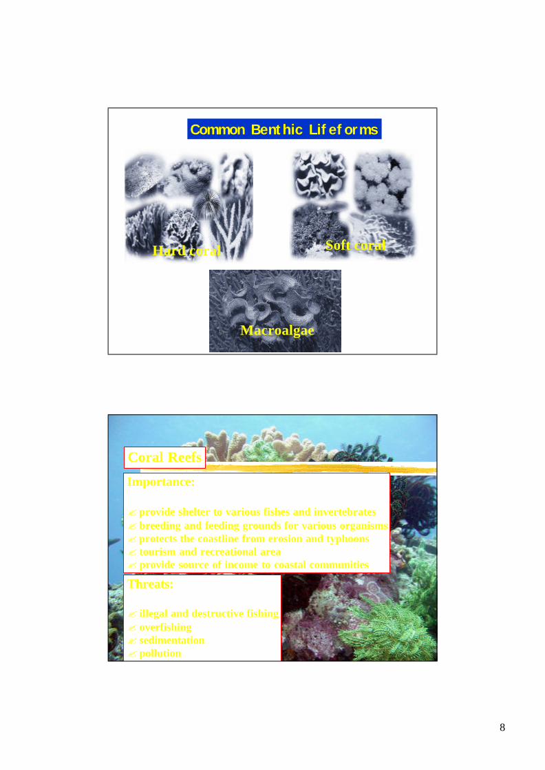
Assessment Methods1. Manta TowRapid reconnaissance technique to gauge the condition ofcoral reefs, its spatial distribution and evaluate synoptic threats in a coastal area.
Parameters measured: lifeformbenthos e.g. live hard coral, soft coral, sand
Expected Output

10
2. Belt and Quadrat Transect Method
A method used for estimating the relative abundance of living and non-living things on the reef bottom observed within a defined area.
Parameters Measured:? percentage cover of hard corals, dead corals, algae, various reef substrates and abundance macro invertebratesWithin the belt transect
Expected Output:? average percentage cover of various reef life formand substrates ? average density of macro invertebrates

11
3. Underwater Fish Visual Census?identification and counting of fishes observed within
a defined area.
Common Reef Fish FamiliesEpinephelinae Lutjanidae Haemulidae
Lethrinidae Caesionidae
Nemipteridae Mullidae Balistidae

12
Common Reef Fish FamiliesChaetodontidae Pomacanthidae Labridae
Scaridae Acanthuridae Siganidae
Pomacentridae Anthiinae Zanclus cornutus
Parameters Measured:Fish species, density and biomassFish species, density and biomass
Expected Output:FISH GRAPHING FORMSite Name: Tuka Reef Municipality & Province: Kiamba, Sarangani
Zone/Sector: Outside Outside Outside Inside Inside Inside
Month & Year: Oct 1998 Mar 1999 Apr 2000 Oct 1998 Mar 1999 Apr 2000
Types/groups
Groupers
Snappers
Sweetlips
Jacks
Fusiliers
Parrotfishes
Surgeonfishes
Rabbitfishes

13
Mangrove Forest
??tropical inshore communities dominated by several tropical inshore communities dominated by several species of trees or shrubs that have the ability to species of trees or shrubs that have the ability to grow in salt water;grow in salt water;??well developed in estuarine areas;well developed in estuarine areas;
Requirements for growth:Requirements for growth:
??moderate salinity (25 moderate salinity (25 pptppt))??neutral acidity (pH 6 to 7)neutral acidity (pH 6 to 7)??yearyear--round warm temperatureround warm temperature??regular surfaceregular surface--water flushingwater flushing??exposure to moderate terrestrialexposure to moderate terrestrial--water runoffwater runoff
Adaptations?shallow rooted;?prop roots;?pneumatophores;?tough and succulent leaves;?reproductive strategy

14
Common Mangrove Genus
Avicennia Bruguiera
Rhizophora Sonneratia
Importance:
? provide protection from erosion and typhoons? feeding/breeding ground of various organisms? maintains water quality? source of timber products? provide shelter for coastal communities
Threats:
? land conversion and reclamation? unsustainable harvest of timber products
Mangrove Forests

15
Parameters measured:
•encountered species;•number of mature trees;•number of saplings;•number of seedlings•diameter at breast height (DBH) •total plant height
Expected Output:• species diversity• relative abundance of seedlings saplings, trees (per hectare)•stem density (per hectare)•basal area
1. Transect Plot Method
Seagrass Beds
?flowering terrestrial plants
?adapted to living submerged in seawater
?seed-producing marine plants
?reproduce by vegetative spreading and by production and dispersal of seeds

16
Common Seagrass Genus
Seagrass Beds
Importance:
? bottom stabilizer? sediment trap? maintains water quality? source of food of various marine organisms
Threats:
? illegal and destructive fishing methods? aquaculture? sedimentation and siltation

17
Parameters Measured:
Expected Output:
• species of segrass and macro invertebrates•% cover of segrass•Substrate type
•Species composition
•Average % seagrass cover
•Density of macroinvertebrates
1. Transect Quadrat Method
Coastal Fishery Resources- fish, invertebrates, seaweeds
18
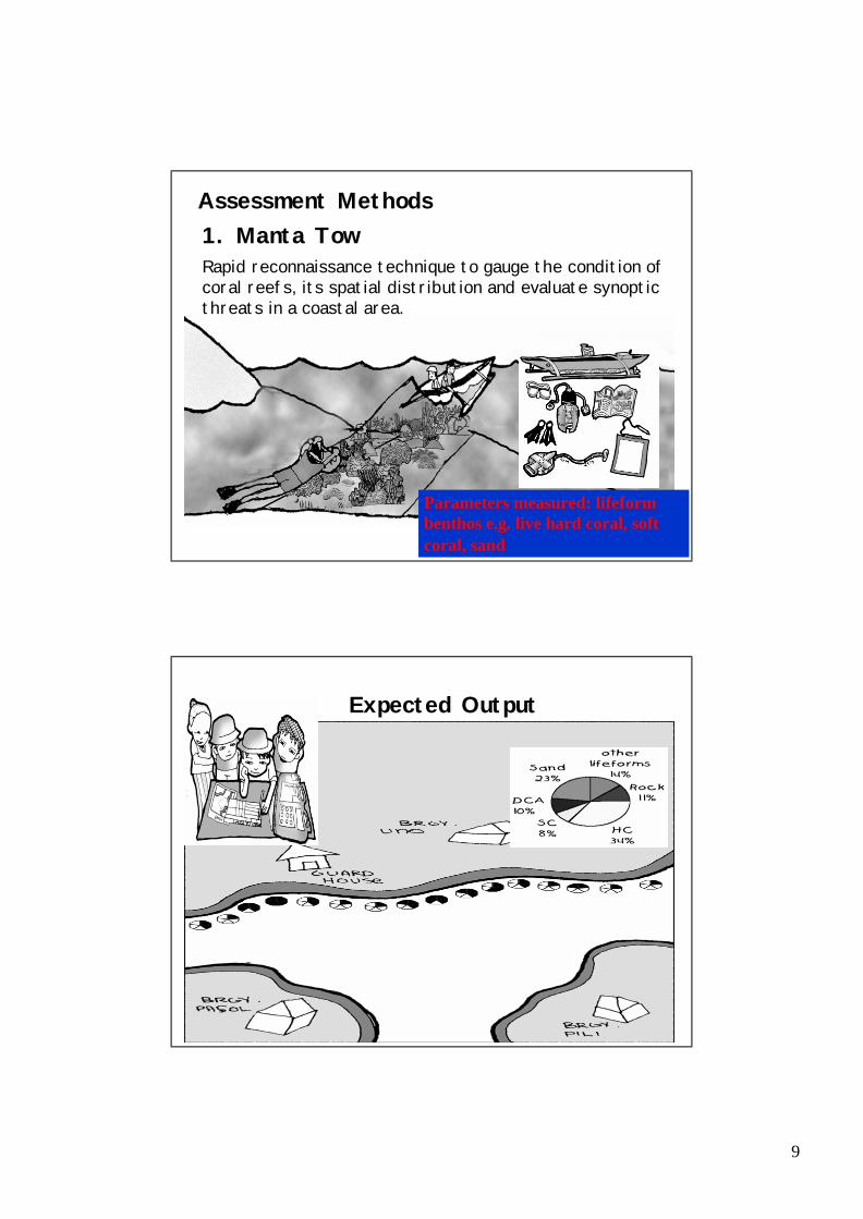
Common Gear Types
Economic benefits from fisheries and coastal ecosystems
Municipal fisheries- food security and livelihood
Total fishery production per fishery sector
• comprise ~32% of total fisheryproduction
Contribution to employment per fishery sector
• provides employment to 5% of thenational labor force; ~68% involvedin municipal fisheries

19
Municipal fisheries production is declining
Trends of catch per unit effort since 1948
• legally most municipal waters are reserved exclusively for use of municipal fishers
Total fishery production trends per sector
1. Seasonal Calendar
Summarize fishery – related activities and resources harvested throughout the year

20
2. Gear Inventory and MappingSpatial Distribution of major fishing gears at different times of the year.
3.Trend Line? graphically illustrates the community’s perception of
certain events and changes;
? focuses on changes in fisheries catch, income and availability of coastal resources
0
10
20
30
40
50
1960s 1970s 1980s 1990s
Year
Fish
cat
ch (K
g)

21
1. Community Resource and Resource Use Map
•
Collective perception of a group of community members about the spatial distribution of coastal resources and habitats
Validated and enriched during PCRA
Data Collation and Analysis
2. Indicative Zoning Map
Initial delineation of primary uses in particular areas based on analysis of PCRA results

22
Identification of environmental, socio-economic and legal-institutional issues through:
?Ecological Profiling/Situational Analysis
?Community Resource- and Resource-Use Mapping
Validation of PCRA Results
The Participatory Coastal Resources Assessment
Orientations for FGDs, survey interviews, mapping, habitat surveys

23
Assessment and Monitoring Methods
Manta TowRapid reconnaissance technique to gauge the condition ofcoral reefs, its spatial distribution and evaluate synoptic threats in a coastal area.
Many coral reef areas were seen to have Many coral reef areas were seen to have poor coverpoor cover
Living hard coral cover with butterfly fish
Massive and encrusting hard corals with some soft corals
Sandy areas and coralline macro algae
Coral reef areas in Sabang showed good coral cover and fish abundance and biomass
24
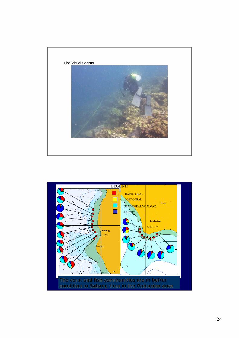
Fish Visual Census
Poblacion
LEGEND
HARD CORAL
SOFT CORAL
DEAD CORAL W/ ALGAE
ABIOTIC
Sabang
The coral and fish communities are in better The coral and fish communities are in better condition in condition in Sabang Sabang than in the than in the PoblacionPoblacion areaarea

25

26
AIMS: 1. Characterize the state and 1. Characterize the state and pressures of the coastal resources pressures of the coastal resources of of MorongMorong;;
2. Evaluate the causes, threats 2. Evaluate the causes, threats and opportunities in the and opportunities in the management of these resourcesmanagement of these resources3. Propose some possible actions 3. Propose some possible actions that may be taken;that may be taken;
Community Consultations
Consolidation of Zonation Plans
Village 1Village 2Village 3Village x
Village 1Village 2Village 3Village x
Village 1Village 2Village 3Village x
Village 1Village 2Village 3Village x
Cluster 1 Cluster 3Cluster 2 Cluster x
Consensus on Municipal Coastal Zonation SchemeSetting of Vision, Mission and Goals Refined/improved Situational Analysis and
Resource- Resource-Use MapsIdentification of appropriate Resource Management Tools

27
Expected Intermediate Outputs of PCRA
1. Spatial and temporal profile of coastal habitats and fisheries
2. Identification of issues to be addressed
3. Preliminary recommendations and possible management guidelines
• To be presented for feedback and validation during barangay (Village) consultations
Next Steps?Facilitating agreements?Action plans and timelines? linking to CRM governanceSMART objectives:? Specific,
? e.g. sustaining fish catch? e.g. tourism
? Measurable, ? e.g. catch, biomass, production per unit area
? Achievable, ? e.g. capacity to do, to be and to become
? Realistic (Relevant)? e.g. within functional decision cycles
? Timebound? short term objectives, medium term mission and long term goals and vision


![WP 4 | CASE STUDY Report: Participatory Budgeting · Transit – Grant agreement n. 613169 – [Participatory budgeting] 1 WP 4 | CASE STUDY Report: Participatory Budgeting Theme](https://static.fdocuments.us/doc/165x107/5d4cd6e988c99339278bc395/wp-4-case-study-report-participatory-budgeting-transit-grant-agreement.jpg)