
The Contributions of Ranger Photographs to … · CONTRIBUTIONS TO ASTROGEOLOGY THE CONTRIBUTIONS...
22
The Contributions of Ranger Photographs to Understanding the Geology of the Moon By N. J. TRASK CONTRIBUTIONS TO ASTROGEOLOGY GEOLOGICAL SURVEY PROFESSIONAL PAPER 599-J Prepared on behalf of the National Aeronautics and Space Administration UNITED STATES GOVERNMENT PRINTING OFFICE, WASHINGTON : 1972 https://ntrs.nasa.gov/search.jsp?R=19730018112 2018-09-21T23:34:35+00:00Z
-
Upload
nguyenhanh -
Category
Documents
-
view
216 -
download
0
Transcript of The Contributions of Ranger Photographs to … · CONTRIBUTIONS TO ASTROGEOLOGY THE CONTRIBUTIONS...

The Contributions ofRanger Photographs toUnderstanding theGeology of the MoonBy N. J. TRASK
C O N T R I B U T I O N S T O A S T R O G E O L O G Y
G E O L O G I C A L S U R V E Y P R O F E S S I O N A L P A P E R 599-J
Prepared on behalf of the National Aeronautics
and Space Administration
UNITED STATES GOVERNMENT PRINTING OFFICE, WASHINGTON : 1972
https://ntrs.nasa.gov/search.jsp?R=19730018112 2018-09-21T23:34:35+00:00Z

UNITED STATES DEPARTMENT OF THE INTERIOR
ROGERS C. B. MORTON, Secretary
GEOLOGICAL SURVEY
V. E. McKelvey, Director
Library of Congress catalog-card No. 72-600U2
For sale by the Superintendent of Documents, U.S. Government Printing OfficeWashington, D.C. 20402 - Price 40 cents
Stock Number 2401-2111

C O N T E N T S
Page
Abstract JlIntroduction 1The Ranger missions 2Methods of study 3Geologic background 3Small-scale maps 4Intermediate-scale maps 5Large-scale maps 9Nature of surface materials 10
Crater statistics 10Morphology of small craters 12Blocks on the lunar surface 12Patterned ground 13
Summary 13References cited _. 15
I L L U S T R A T I O N S
Page
FIGURE 1. Map of the Moon showing impact points of Rangers VII, VIII, and IX J32. Photograph showing mosaic of Ranger IX frames A-66 and B-74, floor of Alphonsus 63. Photograph showing Ranger VII frame A-196, Bonpland H region 84. Photograph showing Ranger VIII frame B-90, southern Mare Tranquillitatis 95. Graph showing cumulative size-frequency distributions of craters 106. Diagram showing hierarchy of geologic features in terms of resolution and fractional coverage of planet achieved by
a photographic system 14
T A B L E S
Page
TABLE 1. Geologic maps produced entirely or in part from Ranger photographs as part of Ranger geologic mapping project. _ J22. Ranger ca mera characteristics 23. Lunar stratigraphic and time divisions as shown on 1:1,000,000-scale maps 44. Summary of improved geologic knowledge of lunar units as shown on Ranger photographs at increasingly larger
s cales 13
m

J2 CONTRIBUTIONS TO ASTROGEOLOGY
by the Lunar Orbiters. Although Ranger photographsof some areas were not as useful as the later Orbiterphotographs, they were important to the lunar programat a time when this conceptual foundation was beingdeveloped.
The main previous analyses and interpretations ofthe Ranger photographs were published by JPL (JetPropulsion Laboratory, California Inst. of Technology,Pasadena, Calif.) (Heacock and others. 1965, 1966),and in a general volume on the lunar surface, whichappeared shortly after the missions (Hess and others,1966). Emphasis in these early reports was on considera-tions of the origins of the several types of featuresshown on the photographs; several of the reports placedconsiderable emphasis on terrestrial analogs. The re-port on the Ranger VIII and IX photographs (Heacockand others, 1966) included five preliminary geologicmaps of selected areas by M. H. Carr, D. J. Milton andD. E. Wilhelms, J. F. McCauley, N. J. Trask, andH. H. Schmitt. These maps provided the starting pointfor the program of Ranger geologic mapping.
TABLE 1.—Geologic maps produced entirely or in part from Rangerphotographs as part of Ranger geologic mapping project
Mission Small scale Intermediate scale Large scale
Ranger VII Bonpland H region(U.S. Oeol. Survey,1971). i
Ranger VIII.. Theophilus quad-rangle (Milton,1968);" Sabineregion (Wilshire,1967).
Ranger IX. - - Ptolemaeus quad-rangle (Howardand Masursky,1968);" Alphonsusregion (Carr, 1969).
Sabine DM region(Trask, 1969).
Alphonsus GA region(McCauley, 1969).
Bonpland PQCregion (Titley,1971).
Sabine EB region(Cannon andRowan, 1971).
1 Also mapped in preliminary form (Titley, 1968).1 Part of 1:1,000,000 series, which covers most of the earthside hemisphere.
The program was carried out on behalf of NASA, theNational Aeronautics and Space Administration, undercontract WO-5171 over the period from September 1965to June 1968. JPL provided the photographs as well asmuch helpful information and assistance. The authorsof individual maps in the Ranger series are cited in thebody of this report. The program was coordinated dur-ing its first year by John F. McCauley and later by theauthor.
THE RANGER MISSIONS
Six vidicon cameras, whose characteristics are de-scribed in table 2, made up the scientific package on eachof the Ranger missions. These cameras record images inthe following manner: A layer of charged photoconduc-tive material is exposed to the scene by means of anelectromagnetically driven shutter. Variations in thebrightness of the scene cause variations in the resistanceacross the photoconductive surface. An electron beam
then scans the surface and recharges the photoconduc-tor. The variation in charge current obtained duringthe scanning is the video signal. This signal, consistingof amplitude variations, is amplified, converted to fre-quency variations, and transmitted to earth. The televi-sion signals from the Ranger spacecraft were receivedat the Goldstone facility in California, converted backto amplitude variations, and displayed on a cathode raytube. The reconstructed image on the cathode ray tubewas then photographed on 35-mm film. In addition tothe film records, a magnetic tape recording was madeof the frequency-modulated signal.
In assessing the use of the Ranger photography forgeologic and topographic purposes, it is important tokeep in mind the major differences between this processand that used to obtain conventional aerial photography.
TABLE 2.—Ranger camera characteristics
Camera
Focal length (mm)/ number
Exposure time (msec)
Scan linesTime between frames (sec)
A
251.02.565
2511
. 1,1505.12
B
762.02.5658.4
111,150
5.12
Pi
762.0.2
22.12.8
300.84
P!
762.0.2
22.12.8
300.84
Pi
251.0
9
26.32.8
300.84
P.
261.0.2
26.32.8
300.84
1 The actual field of view is somewhat smaller than the given numbers because ofthe presence of a mask at the edge of the vidicon target which is used to determinescene black on each scan of the electron beam.
The fields of view of the six cameras partially over-lapped so that some parts of the lunar surface appearedin the images of two or more cameras—an essentialsafety characteristic of early space photography experi-ments. Two cameras had a full format (11 by 11 mm),four a reduced format (2.8 by 2.8 mm). These sizesshould also be kept in mind when comparing enlarge-ments (9 by 9 in., for example) of the Ranger recordswith conventional aerial photographs. The short focallength cameras had a system angular resolution of8.8 X 1(H radians, and the long focal length cameras asystem angular resolution of 2.9 X1Q-4 radians. In com-parison, the Lunar Orbiter film system had a systemangular resolution of 2.1 X 10~5 radians for the long focallength camera. Although a Lunar Orbiter type systemwould have given much better resolution than that pro-vided by Ranger, such a system requires the onboarddevelopment of film and thus would clearly have beenimpractical for an impacting mission, wherein all theimages are returned to earth in a short time.
The aiming points for the three Ranger missions werechosen with a view to learning about the nature of thelunar surface as a whole and to providing informationneeded for the Surveyor and Apollo programs of lunarlandings. Rangers VII and VIII impacted on mare

CONTRIBUTIONS TO ASTROGEOLOGY
THE CONTRIBUTIONS OF RANGER PHOTOGRAPHS TOUNDERSTANDING THE GEOLOGY OF THE MOON
By N. J. TRASK
ABSTRACT
Vidicon photographs returned to earth by Rangers VII, VIII,and IX in 1964 and 1965 were used to study the details of lunargeologic units previously recognized from earth-based telescopicphotographs and to make geologic maps at a variety of scales.The photographs from each mission changed continuously inscale as the spacecraft approached impact. The final frameshad resolutions some 1,000 times better than the best earth-based photographs. Lunar stratigraphic units mapped at a scaleof 1:1,000,000 displayed, at these larger scales, differences inproperties and, possibly, in ages, but a clear-cut stratigraphicsuccession of subunits was not apparent. The plains-formingmaterials in both terra and mare were divisible into unitsmainly on the basis of the differences in the total number Ofsuperposed craters and in the relative number of craters ofvarious morphologic types. Important details of the rims, walls,and floors of the craters Sabine and Ritter suggested that thesecraters might be of internal origin rather than impact origin.A number of smaller craters were interpreted to be of internalorigin on the basis of their shape, rim textures, and alinementalong linear depressions of structural origin. The largest scalemaps showed mainly small craters of various morphologic formsand a few blocks; they served as forerunners of large-scale mapsmade from Orbiter photographs that were used in planningApollo missions.
The nature of the uppermost part of the lunar surface wasrevealed by the statistical abundance and morphology of smallcraters, the presence of blocks, and the presence of patternedground. Although not entirely conclusive, these several kinds ofevidence, together with lunar photometric and polarimetricdata, strongly suggested that the surface consists of fine-grainedfragmental material formed, with some local exceptions, bymeteorite impact. Subsequent lunar probes have shown that thismodel is substantially correct.
INTRODUCTION
On July 31, 1964, at 13:25:49 G.m.t. (Greenwichmean time), the Ranger VII spacecraft impacted on themoon after sending to earth some 4,000 television viewsof the lunar surface. The scenes transmitted just beforeimpact had a resolution 1,000 times better than that ofthe best earth-based telescopic photographs. Thus was
inaugurated the era of closeup geologic investigation ofthe moon.
Eanger VIII and Ranger IX impacted on the moonon February 20,1965, and March 24,1965, and returnedto earth some 7,000 and G,000 photographs, respectively.The quality of many of the photographs taken early inall three missions is inferior to that of earth-basedtelescopic photographs, but it improves dramatically,as does resolution, in photographs taken as each space-craft neared the lunar surface. Each suite of photo-graphs, therefore, provides a bridge between the appear-ance of the lunar surface at telescopic resolutions (ap-proximately 1 km) and its appearance at resolutionsdown to about 1 m (meter). Prior to the successfulRanger missions, earth-based telescopic photographsand observations had been used by the U.S. GeologicalSurvey to make reconnaissance geologic maps of themoon at a scale of 1:1,000,000. The moonwide geologicpicture provided by this mapping helped in targetingthe Rangers and in placing the Ranger photographs incontext. The Ranger photographs in turn providedcloseup views of several of the units that had beenmapped at small scale and suggested a program of moredetailed geologic mapping of the small areas coveredby the three missions. This report summarizes the re-sults of that mapping program.
A total of seven maps at scales ranging from 1: 250,-000 to 1: 5,000 were prepared; in addition, the Rangerdata were used to revise and clarify geologic relationson published versions of two quadrangles in the1:1,000,000 series (table 1). This report is intendedto be used in conjunction with these maps and to sum-marize the contributions of the Ranger program tounderstanding the geology of the moon. At the timethe Ranger program began, it had the additionalpurpose of exploring various methods and proceduresthat might be used in large-scale geologic mapping fromphotographs with a much wider format to be provided
Jl

CONTRIBUTIONS OF RANGER PHOTOGRAPHS TO UNDERSTANDING THE GEOLOGY OF THE MOON J3
material near the lunar equator, Ranger IX on the floorof the highland crater Alphonsus (fig. 1). It was knownbefore the Ranger missions that the first manned lunarlandings would probably be on mare material; hence thefirst two Rangers were sent to investigate the maria.Ranger VII was aimed at an area referred to at the timeas an embayment or sinus at the north end of MareXubium; after the Ranger VII mission this area wasrenamed Mare Cognitum ("the sea that is known"). Ithas a slightly reddish hue (Kuiper, 1965) and is crossedby several rays of the systems surrounding both Tychoand Copernicus. The impact point was on a faint ray.Ranger VIII was aimed at the southwest corner of MareTranquillitatis, an area that reflects more strongly inthe blue part of the spectrum than the Ranger VII areaand is unrayed within 5 km of the impact point. As itcruised toward impact, Ranger VIII photographedlarge areas of the uplands southwest of Mare Tranquil-litatis and the two craters Sabine and Ritter at betterthan earth-based resolution. The areas near the impactpoints of Rangers VII and VIII were not greatly differ-ent in their large-scale appearance, and a highland sitewas clearly indicated for Ranger IX. The crater Al-phonsus was chosen because of the small dark-halocraters on its floor and because reports of transient lunarphenomena within the crater (Kozyrev, 1962) had gen-
' : '"
Jft :
V'
''' - s1
' :-'NV*R A N G E R
^•'^VV:4V /*• f;'
• -
FIOUBE 1. — Impact points of Ranger VII, VIII, and IX.
crated considerable interest in its detailed appearance.The level, highly cratered plains-forming material onthe floor is similar to many other tracts on the lunarhighlands. Before it impacted, Ranger IX providedviews at better than earth-based resolution of the ruggedhighlands, smooth terra plains, and maria surroundingAlphonsus.
METHODS OF STUDY
Stereoscopic and monoscopic examination of good-quality sets of the Ranger photographsa has been theprincipal method of study used to construct the maps.The base-height ratio in pairs of the photographs isvery weak for good stereopsis; nevertheless, stereo-scopic viewing is extremely helpful in emphasizing sub-tle detail and suppressing the lines and spots producedby noise in the transmission system. The geologic in-terpretation was checked against available Lunar Or-biter photographs of the areas under consideration. Thegeologic data were plotted on shaded-relief base mapsprepared by the U.S. Air Force Aeronautical Chartand Information Center.
Information on the albedo of the lunar surface in theareas covered by some of the small- and intermediate-scale maps was obtained from earth-based telescopicphotographs taken near full moon; for several maps,the albedo information was systematized by scanningthe full-moon photographs with a microphotometer andtracing out lines of equal photographic intensity withan isodensity tracer.
GEOLOGIC BACKGROUND
Geologic maps at a scale of 1:1,000,000 preparedfrom earth-based observations provide the backgroundagainst which to consider the new information that theRanger photographs conveyed. (For reviews see Wil-helms, 1970, and Mutch, 1970.) A lunar stratigraphiccolumn has been worked out for the region around MareImbrium, where a series of well-defined map units isvisible (Shoemaker and Hackman, 1962). Some of theseunits can be correlated with similar-appearing units inother parts of the moon. The major time-stratigraphicdivisions (systems) correspond to periods of timemarked by major events in the Mare Imbrium region(tableS).
1 Highest quality prints are available In a limited number of photo-graphic editions prepared by Q. P. Kuiper for the Jet PropulsionLaboratory. Collections of half-tone prints were assembled by NationalAeronautics and Space Administration (1964, 1965a, b, 1966a, b).
J4 CONTRIBUTIONS TO ASTROGEOLOGY
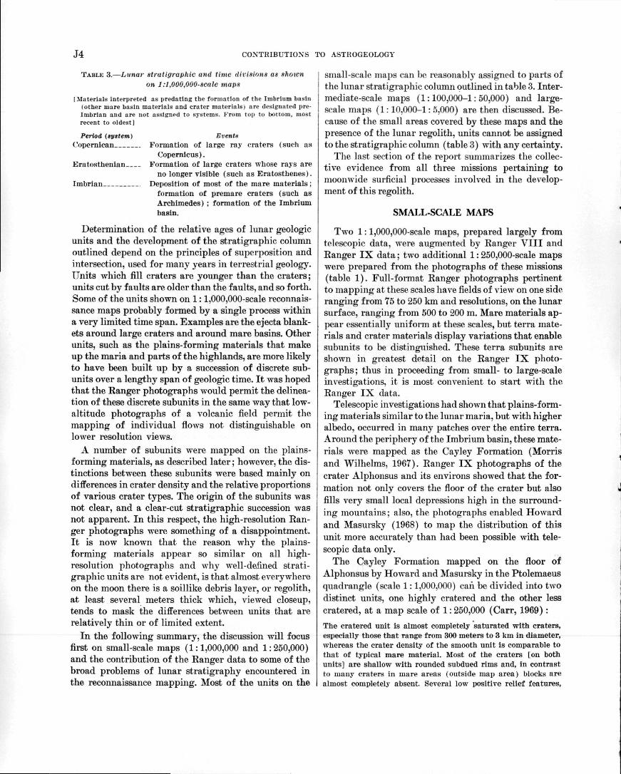
TABLE 3.—Lunar stratigraphic and time <livi.ii'>ns an xlirncnon I:l,000,000-sca1e map*
[Materials interpreted as predating the formation of the Imbrlum basin(other mare basin materials and crater materials) are designated pre-Imbrian and are not assigned to systems. From top to bottom, mostrecent to oldest]
Period (tyttem)Copernican
Eratosthenian
Imbrian
EventsFormation of large ray craters (such as
Copernicus).Formation of large craters whose rays are
no longer visible (such as Eratosthenes).Deposition of most of the mare materials ;
formation of premare craters (such asArchimedes) ; formation of the Imbriumbasin.
Determination of the relative ages of lunar geologicunits and the development of the stratigraphic columnoutlined depend on the principles of superposition andintersection, used for many years in terrestrial geology.Units which fill craters are younger than the craters;units cut by faults are older than the faults, and so forth.Some of the units shown on 1:1,000,000-scale reconnais-sance maps probably formed by a single process withina very limited time span. Examples are the ejecta blank-ets around large craters and around mare basins. Otherunits, such as the plains-forming materials that makeup the maria and parts of the highlands, are more likelyto have been built up by a succession of discrete sub-units over a lengthy span of geologic time. It was hopedthat the Ranger photographs would permit the delinea-tion of these discrete subunits in the same way that low-altitude photographs of a volcanic field permit themapping of individual flows not distinguishable onlower resolution views.
A number of subunits were mapped on the plains-forming materials, as described later; however, the dis-tinctions between these subunits were based mainly ondifferences in crater density and the relative proportionsof various crater types. The origin of the subunits wasnot clear, and a clear-cut stratigraphic succession wasnot apparent. In this respect, the high-resolution Ran-ger photographs were something of a disappointment.It is now known that the reason why the plains-forming materials appear so similar on all high-resolution photographs and why well-defined strati-graphic units are not evident, is that almost everywhereon the moon there is a soillike debris layer, or regolith,at least several meters thick which, viewed closeup,tends to mask the differences between units that arerelatively thin or of limited extent.
In the following summary, the discussion will focusfirst on small-scale maps (1:1,000,000 and 1:250,000)and the contribution of the Ranger data to some of thebroad problems of lunar stratigraphy encountered inthe reconnaissance mapping. Most of the units on the
j small-scale maps can be reasonably assigned to parts of| the lunar stratigraphic column outlined in table 3. Inter-
mediate-scale maps (1:100,000-1:50,000) and large-scale maps (1:10.000-1: o.OOO) are then discussed. Be-cause of the small areas covered by these maps and thepresence of the lunar regolith, units cannot be assignedto the stratigraphic column (table 3) with any certainty.
The last section of the report summarizes the collec-tive evidence from all three missions pertaining tomoonwide surficial processes involved in the develop-ment of this regolith.
SMALL-SCALE MAPS
Two 1:1,000,000-scale maps, prepared largely fromtelescopic data, were augmented by Ranger VIII andRanger IX data; two additional 1: 250,000-scale mapswere prepared from the photographs of these missions(table 1). Full-format Ranger photographs pertinentto mapping at these scales have fields of view on one sideranging from 75 to 250 km and resolutions, on the lunarsurface, ranging from 500 to 200 m. Mare materials ap-pear essentially uniform at these scales, but terra mate-rials and crater materials display variations that enablesubunits to be distinguished. These terra subunits areshown in greatest detail on the Ranger IX photo-graphs; thus in proceeding from small- to large-scaleinvestigations, it is most convenient to start with theRanger IX data.
Telescopic investigations had shown that plains-form-ing materials similar to the lunar maria, but with higheralbedo, occurred in many patches over the entire terra.Around the periphery of the Imbrium basin, these mate-rials were mapped as the Cayley Formation (Morrisand Wilhelms, 1967). Ranger IX photographs of thecrater Alphonsus and its environs showed that the for-mation not only covers the floor of the crater but alsofills very small local depressions high in the surround-ing mountains; also, the photographs enabled Howardand Masursky (1968) to map the distribution of thisunit more accurately than had been possible with tele-scopic data only.
The Cayley Formation mapped on the floor ofAlphonsus by Howard and Masursky in the Ptolemaeusquadrangle (scale 1:1,000,000) can be divided into twodistinct units, one highly cratered and the other lesscratered, at a map scale of 1: 250,000 (Carr, 1969):
The cratered unit is almost completely saturated with craters,especially those that range from 300 meters to 3 km in diameter,whereas the crater density of the smooth unit is comparable tothat of typical mare material. Most of the craters [on bothunits] are shallow with rounded subdued rims and, in contrastto many craters in mare areas (outside map area) blocks arealmost completely absent. Several low positive relief features,

CONTRIBUTIONS OF RANGER PHOTOGRAPHS TO UNDERSTANDING THE GEOLOGY OF THE MOON J5
principally northwest- and northeast-trending ridges, occur onthe floor, especially in the west half.
The Cayley Formation is now thought to be a mixtureof volcanic materials and erosioiial debris derived fromthe highlands which in most places surround it. Howardand Masursky (1968) believed that much of the unitcan be attributed to highly fluid flows, perhaps ashflows, which were widely deposited, shed off highs, andponded in basins. The two discrete units within the for-mation on the floor of Alphonsus suggest successivepulses in the development of the Cayley consistent withvolcanism playing some role in its genesis.
Other features on the floor of Alphonsus which couldbe portrayed with increased clarity on small-scale mapswere the dark-halo craters and craters on rilles (fig. 2).The dark-halo craters have unusually low albedos forsmall craters on the terra; the dark material covers notonly the outer rims but the interiors of the craters aswell. The Hanger photographs show clearly that thedark material fills parts of the rilles along which thecraters are located. In these respects these dark-halocraters differ from many other dark-halo craters on themoon which have interiors of moderate to high albedoand which have no obvious structural control. Othercraters on the floor of Alphonsus are located along rilles,but their albedo is the same as that of the surroundingmaterials.
The origin of the crater Alphonsus is not clear; mostlikely it is an ancient impact scar. Clearly, it has beenseverely modified by volcanism since its formation, asargued by Carr (1969) :
The dark-halo craters provide the clearest evidence of volcan-ism within Alphonsus. The fact that they are located on rillesis clearcut evidence of structural control. Furthermore, becausetheir rim materials fill adjacent depressions, they are not sub-sidence features. The similar rille craters * * * are probablyolder dark-halo craters whose halos have been destroyed byoverturn of the near-surface materials. Other probable volcaniccraters are those which form chains * * * parallel to structurallineaments on the floor and rim of Alphonsus. The volcanismwas possibly triggered by the Alphonsus impact (Carr, 1964),which may have created a local thermal anomaly and causedextensive brecciation beneath the crater, enabling magma to riseto the surface.
The area photographed by Hanger VIII nearDelambre southwest of the impact point contains bothplains-forming materials and more rugged terrain. Onthe geologic map of the Theophilus quadrangle (scale1:1,000,000), Milton (1968) distinguished two units—arugged unit and a relatively smooth unit with scattereddomes and irregular depressions. Two basic units, a hillyunit and a plains unit, were also recognized in the samearea on the Kanger VIII photographs. These werefurther divided by Wilshire (1967) on the geologic mapof the Sabine region (scale 1:250,000). The plains-
I forming materials were divided into three subunits ac-cording to the number of small craters superposed oneach unit. These subunits are probably analogous to thesubunits in the Cayley Formation on the floor ofAlphonsus. The hilly unit was divided by Wilshire ac-cording to the ruggedness of the topography; the unitsrange from gently undulating to rugged steep hills.
The two large craters Ritter and Sabine, in the south-west corner of Mare Tranquillitatis, posed a problem forlunar geologists in pre-Ranger studies. The fact thatthese two very similar craters are so close together butthat neither appears to have def ormed the other led someworkers to suspect that they might be of internalorigin—calderas which formed by collapse of a pile ofvolcanic deposits. Whether the craters were older oryounger than the mare was also in doubt. These relation-ships were greatly clarified by the Ranger VIII photo-graphs. Wilshire (1967) interpreted both craters as ofinternal origin,* * * because the percentage of their floors that is occupied byslump blocks is greater than in impact craters of comparable sizeand because a field of secondary impact craters such as is foundaround typical post-mare impact craters of comparable size ap-pears to be lacking. Ritter and Sabine are clearly younger thanthe formation of the mare material because the hummocky ejectablanket surrounding them partly buries the two major grabenstructures (Rimae Hypatia I and II) that in turn cut the marematerial.
Also, the floors of the craters are anomalously high forpostmare craters, and the rim materials are gentlyrolling and relatively smooth, unlike the rough, hum-mocky deposits that surround probable postmare impactcraters such as Copernicus. Sabine and Ritter thus ap-pear to be more like terrestrial calderas than impactstructures; they are similar to the crater Kopff withinthe inner ring of the Orientale basin, which McCauley(1968) suggested might be of internal origin on the basisof evidence in Lunar Orbiter IV photographs.
INTERMEDIATE-SCALE MAPS
Map scales ranging from 1:100,000 to 1: 50,000 areclassed here as intermediate. Three maps were made atthese scales, one from each mission (table 1). The full-format Ranger photographs used have fields of viewon one side ranging from 5 to 75 km and resolutionsranging from 200 to 10 m. All level areas on the moonappear more intensely cratered on these photographs(figs. 2, 3, 4) than on photographs of smaller scale. Onboth intermediate- and large-scale maps, units asso-ciated with craters occupy a significant fraction of themapped area.
The system used to map the craters was entirely de-scriptive. Materials of craters with sharp rims andbright haloa formed one map unit, those of slightly sub-
460-198 O - 72 - 2

J6 CONTRIBUTIONS TO ASTROGEOLOGY

CONTRIBUTIONS OF RANGER PHOTOGRAPHS TO UNDERSTANDING THE GEOLOGY OF THE MOON J7
clued craters with albedos the same as the surroundingmaterial formed another, and so on. Any other systemwould have involved assumptions about the origin ofthe craters; as noted in the final section of this report,the Ranger photographs alone did not permit firmconclusions on this question. Mapping based on LunarOrbiter photographs, in contrast, was based on the as-sumption that the subdued craters and gentle depres-sions had once been sharp and had been degraded bysubsequent impacts and downslope movement of mate-rial—an assumption that seemed reasonable after ex-amining the entire body of Lunar Orbiter photographs.Craters were then mapped according to their relativeages. Small highly subdued craters were inferred to bethe same age as larger sharper craters because crater de-struction proceeds faster for small craters than forlarger craters. On maps made from Orbiter photo-graphs, therefore, a map unit shows craters of the sameinferred age, even though they may have differentmorphologies.
The large number of craters made it difficult to mapstratigraphic units on intermediate-scale maps. Someadditional subdivisions of the Cayley Formation weremapped, however, and some fairly distinct subdivisionsof the mare material were recognized. The two subunitsof the Cayley Formation on the floor of Alphonsus,recognized at small scales, were mapped by McCauley(1969) at a scale of 1: 50,000. In addition, he recognizedtwo units in the heavily cratered part of the formation—one with a northeast lineation trend and one with both anortheast and northwest lineation trend. The differencesin the crater populations on these units, as well as onothers, within the crater Alphonsus were documentedby McCauley (1969) with detailed crater statistics. Thetotal number of craters on each stratigraphic unit waspresented; in addition, all craters larger than approxi-mately 200 m were classified according to morphologicfreshness, and counts were made of each morphologictype on each unit.
The Cayley Formation on the floor of Alphonsus canbe seen at this scale to have a large number of craterswith low, smooth gently convex upward rims. Thesecraters are "morphologically distinct, and the majorityof those mapped show evidence of structural control.These are interpreted as volcanic craters of the maartype which played an important role in filling the Al-phonsus basin" (McCauley, 1969). (See fig. 2, this re-port.) The floor of Alphonsus also has numerous north-and northeast-trending rilles and linear depressions(fig. 2), some with steep walls, flat floors, and sharpedges and others with shallower, U-shaped floors androunded edges. One rille passes gradationally into aseries of coalescing low-rimmed craters of the type in-
terpreted as maars. The rilles and "linear depressionsmay be eroded and partly filled remnants of originallysharper fault troughs such as Rima Alphonsus I. Some,however, particularly those that grade into rimlesschain craters, are probably collapse structures" (Mc-Cauley, 1969).
Features of internal origin such as convex-rimmedcraters and linear depressions and troughs and asso-ciated craters appear to be especially numerous on thefloors of craters. The floor of Copernicus has many suchfeatures, as well as possible cinder cones (Hartmann,1968). The craters and depressions of internal originon the floor of Alphonsus may be the worndown equiv-alents of features that once resembled those now seenon the floor of Copernicus. In this respect, the CayleyFormation on the floor of Alphonsus may differ fromthe formation where typically developed outside ofcraters such as in its type area (Morris and Wilhelms,1967). Lunar Orbiter photographs (site II P-4, for ex-ample) indicate that features that are clearly of internalorigin are rare in these areas outside of large craters,and the smooth less-cratered subunit which covers muchof the floor of Alphonsus is less widespread.
Divisions within the mare material were mappedby Trask (1969) on the basis of Ranger VIII photo-graphs in the Sabine DM region, a part of southwestMare Tranquillitatis (scale 1:50,000). Mare materialmakes up one of the most widespread continuous geo-logic units on the moon, is confined largely to the earth-side hemisphere, and is the site of the first two Apollolandings. Understanding of possible local, large-scalevariations in these materials was an early goal of lunargeologic research. The nomenclature of the mare mate-rials has undergone continual revision. (For a review,see Wilhelms, 1970.) On current small-scale maps, thematerials are referred to simply as mare material; mostof this unit is assigned to the Imbrian System (table3), but some fairly large patches have been assignedto the Eratosthenian. The mare material in the SabineDM region can be seen on Orbiter photographs to beproperly assigned to the Imbrian System; the limitedcoverage of the Ranger photographs did not permitsuch an assignment, and the material was mapped onlyas mare material, age unassigned.
The two divisions mapped in the mare material are"(1) [a] unit * * * with a relatively high density ofsubdued craters in the size range 50-200 meters, and(2) a smoother unit * * * with a lower areal density ofsuch craters and fewer indistinct ridges and irregulardepressions" (Trask, 1969). The smoother,less-cratered,unit appears to lie slightly below the more-heavily-cratered unit, although this appearance may be only anillusion because the photographs have very weakstereopsis. Trask (1969) interpreted the smooth unit as

J8 CONTRIBUTIONS TO ASTROGEOLOGY
a relatively thick accumulation of impact-produceddebris, and the more-cratered unit as an area where suchdebris is relatively thin. Similar, relatively smooth unitsin other areas have been interpreted as volcanic mate-rials younger than the more-heavily-cratered terrain.
The Bonpland H region, photographed by RangerVII and mapped at 1:100,000 (U.S. Geol. Survey,1971), is characterized by distinct clusters of craters,including both circular craters and elongate gougesand depressions (fig. 3). These are apparently fields ofsecondary impact craters; however, not all can be clearlyassociated with a given primary. All the clusters in thecentral part of the region were attributed to the crater
Tycho by Shoemaker (1966) ; Kuiper (1965), however,attributed some clusters to Tycho and some to Coperni-cus. A careful analysis of the albedo patterns aroundthe clusters, as well as of the morphology and distribu-tions of craters within each cluster, suggested that thesecondary impact craters were indeed related to bothTycho and Copernicus (U.S. Geol. Survey, 1971).
Mare ridges are also conspicuous in the BonplandH region. Their intricate complexity was shown for thefirst time by the Ranger VII photographs. The positivetopography of the ridges extends up onto the rims andto the rim crests of several fairly young craters, and oneridge appears to cross a crater floor. These observations
FIGURE 3.—Ranger VII A-camera frame 196 taken 18 seconds before impact showing clusters of circular craters and elongategouges and depressions in Bonpland H region. North at top.

CONTRIBUTIONS OF RANGER PHOTOGRAPHS TO UNDERSTANDING THE GEOLOGY OF THE MOON J9
led Urey (1965, p. 143) to suggest that the ridges areyounger than the craters. The relationship, however,may actually be the opposite of this (U.S. Geol. Survey,1971); specifically, the rim deposits of the craters mayhave slumped off the topographic highs of the ridges,or they may have been initially thinner there and thusunrecognizable on the photographs. The ridge crossingthe crater floor could be a resistant dike that predatedthe crater and is now expressed by positive relief.
LARGE-SCALE MAPS
Two large-scale maps were prepared, both in mareareas—one at 1:10,000 in the Ranger VII impact area(Titley, 1971) and one at 1:5,000 near the Ranger
VIII impact point (Cannon and Rowan, 1971). Thefield of view of full-format photographs used rangedfrom 1 to 5 km on one side, and the resolutions from 1to 10 m. The final partial-format photographs withfields of view as small as 60 m on one side were alsoused. At these scales, the lunar surface everywhere iscovered with innumerable craters ranging downwardin size to the limit of photographic resolution. Positive-relief features are rare, but blocks appear here and there(fig. 4; Kuiper, 1966), hinting at but not demonstratingthe particulate nature of the surface materials. Becauseof the large number of small craters and the cover ofparticulate material, the large-scale photographs do notreveal any stratigraphy in the underlying bedrock, but
FIGURE 4.—Final Ranger VIII B-eamera frame 90 taken just before impact in southern Mare Tranquillitatis, showing numeroussmall sharp craters superposed on larger more subdued craters: p, patterned ground on rim of large pan-shaped depression;b, field of blocks up to 10 m across. North at top.

J10 CONTRIBUTIONS TO ASTROGEOLOGY
record only variations from place to place in surfacetopography. They were thus valuable for determiningthe fine-scale nature of the surface material and forassessing properties critical to the problem of landingon the lunar surface at a time when nothing else wasknown about the moon at these scales. The inferencesthat were made about the surface materials are sum-marized in the section "Nature of Surface Materials."
Maps made from these large-scale photographs yieldpractical information, rather than new stratigraphic in-sights, and are similar to maps that were later producedfrom Orbiter photographs and used to guide the courseof Apollo missions on the surface and to place the re-sults of such exploration in proper context. They areroughly analogous to detailed, large-scale mine mapsthat guide a prospector in searching for new ore. Indi-vidual craters and blocks were the principal elementsmapped. The craters range from sharp, bright-haloeddistinct craters to gentle, indistinct depressions. Themap units reflect these various crater morphologies.
NATURE OF SURFACE MATERIALS
Before the successful Ranger missions, it was knownthat the moon was exceedingly rough on a scale com-parable to the wavelength of light. (See for example,Minnaert, 1961.) Telescopic observations, however, indi-cated that the moon is relatively smooth over distancesof several hundred meters, and early radar work indi-cated that this smoothness continues down to slopelengths of about 1 meter (Evans and Pettengill, 1963).The very rough microstructure was generally ascribedto either accumulations of a very fine grained particu-late material in relatively open packing or to very po-rous foams or slags. Hapke (1964) reviewed photo-metric and polarimetric evidence, which favored thefirst of these alternatives. How deep such particulatematerial might be was not known.
Inferences about the nature of the lunar surface mate-rials were drawn from three main aspects of the Rangerphotographs: the size-frequency distribution of craters,the morphology of small craters, and the size and dis-tribution of blocks on the surface. Another element ofthe topography seen at large scales that had a bearingon the interpretation of the surface materials was theseries of closely spaced ridges and troughs known aspatterned ground.
CRATJER STATISTICS
One of the chief results of studies of the Rangerphotographs was the extension of crater size-frequencycurves some three orders of magnitude downward incrater diameter from the 1-km limiting resolution on thebest telescopic photographs to near 1-meter resolution
on the final Ranger frames. The number of craters ofvarious sizes and their morphologies were critical to theproblem of selecting sites for manned landings on themoon, and the Ranger photographs showed clearly thatthe moon was smooth enough over 1-meter slope lengthsto permit such landings. Crater statistics also providedevidence bearing on the origin of the craters and thenature of the surface materials, but did not provide thefinal answers. Cumulative size-frequency diagrams oftotal craters for the three missions are given in figure 5.The following aspects of the curves are worthy of note.1. Curves for the maria (Rangers VII, VIII) show a
marked upward break in slope from slopes of ap-proximately — 1.7 to slopes of approximately —3at crater diameters of between 5 and 1 km. Thevery rapid increase in the number of craters in thisinterval is also measurable on high-resolutionphotographs taken at Lick Observatory, which be-came available at about the same time as the Ranger
10
10'°
109
10"
107
oc
£ i'ftLU
I—
5 10" —
103 -
IO2 —
10'
Curve for possiblesteady - state
crater frequency
EXPLANATION
O
Ranger VIIMare Cognitum
Ranger VIMMare Tranquillitatis
QRanger IX
Floor of Alphonsus
01 10 100 1000(1 km)
CRATER DIAMETER,IN METERS
10000 100000
FIGURE 5.—Cumulative size-frequency distributions of cratersphotographed by Rangers VII, VIII, and IX. The area sampledia progressively smaller for smaller size craters. Craters largerthan 2 km diameter on Mare Tranquillitatis counted fromunpublished Lick Observatory photograph ECD-36.

CONTRIBUTIONS OF RANGER PHOTOGRAPHS TO UNDERSTANDING THE GEOLOGY OF THE MOON Jll
photographs. The existence of the-up ward break inslope means that extrapolations of crater countsin the maria from earlier earth-based observations(McGillem and Miller, 1962) give small-crater fre-quencies that are much too low.
2. Both curves for the maria undergo a second changein slope and become flatter at crater diameters ofbetween 300 and 600 m. The overall slope of thecurves'between diameters of 300 and 1 m is —2. Theresultant frequency of craters at 1 m is, of course,much lower than it would be if the higher slopesabove 300 m diameter were maintained.
3. The crater frequency on the plains-forming materialof the floor of Alphonsus is as much as an order ofmagnitude higher than on the maria at diametersof 1 km; the size-f requency curve has a relativelysteep slope of — 3 for diameters above 2 km and aslope of -2 over the rest of its length, mergingwith the curve for the mare photographed byRanger VIII at diameters of 10 m.
In the interpretation of crater statistics derived fromthe Ranger photographs, it should be borne in mindthat, both the sun angle and the trace of the subspace-craft point on the lunar surface differed appreciablyfrom one mission to another. The rather high sun anglein the Ranger VII mission probably results in failureto detect many subdued craters on Ranger VII photo-graphs. Ranger VIII was maintained in the cruise modewithout terminal maneuver so that successive photo-graphs portray overlapping rather than nested areas;the crater statistics are thus a composite, with the sta-tistics for small craters derived from a different areathan the statistics for large craters.
The close agreement of the frequencies of small cra-ters on three diverse surfaces photographed by theRanger spacecraft (fig. 5) indicates that the most recentcratering history on all three has been similar. Thehigh-resolution photographs from Lunar Orbiter givethe same impression and have a rather monotonoussimilarity with a few exceptions. At larger crater diam-eters (100 m-1 km), there are much larger differences inthe crater frequencies (fig. 5), a fact also evident onOrbiter photographs. Proposed cratering histories ofthe moon must take into account these fundamentalobservations.
The question of the nature of the lunar surface mate-rial is tied to the question of the origin of craters. Shoe-maker (1966) and Shoemaker and others (1966)proposed that most of the subdued craters were oncesharp and have been degraded by subsequent micro-meteorite impacts, seismic shaking, and downslopemovement of material. In this model, parts of the cratersize-frequency curves for large crater sizes refer to
craters that have not been completely destroyed; theyindicate the total number of craters larger than a givensize that have ever been present on these surfaces. Forthe maria, these parts of the curves extend from craterdiameters of from 300 to 600 m to the largest sizes andhave slopes of approximately — 3 for diameters as muchas 5 km and shallower slopes for diameters above 5 km;for the floor of Alphonsus, this part of the curve extendsfrom diameters of 2 km to larger sizes and has a slope ofapproximately —3. The parts of all three curves extend-ing to the smallest craters (slope of —2, fig. 5) wouldrepresent a steady-state population in which craters aredestroyed at approximately the same rate at which theyare formed. Thus, the number of craters smaller than300-600 m in diameter would remain constant as thesuperposition of new craters destroyed preexisting ones.The close agreement of the frequencies of small craterson the three diverse surfaces sampled by the Rangers isconsistent with this model. Because of the continualdestruction of craters, most of the surface would becovered with a layer of fragmental debris several metersthick.
A complication to the steady-state model is the factthat the final frames of each Ranger mission show anincrease in the proportion of sharp craters in the sizerange 10-50 m (Trask, 1967; Chapman, 1968). In asimple steady-state model of crater formation and de-struction, the rate of crater formation is a simple powerfunction of crater diameter, and the rate of crater de-struction is proportional to the rate of crater formation(Moore, 1964). In such a model, the proportion of sharpcraters should be the same at all crater diameters be-cause the rates of crater formation and destructionwould be balanced in the same way for all crater diame-ters below the limiting steady-state diameter. The factthat the proportion of sharp craters is not constant withcrater diameter but varies in a regular way indicatesthat if the impact model is correct, the rate of craterformation or the rate of crater destruction or both mayhave varied with time and may have departed from asimple power dependence on crater diameter.
According to another interpretation, which explainedthe observed size-frequency distribution of cratersequally well, the subdued craters are largely passive col-lapse depressions in lava flows (Kuiper and others,1966). The subdued form would be a primary attribute,rather than the result of subsequent degradation. Thesharper craters would be both primary and secondaryimpact craters, but they would not be numerous enoughto cause the complete destruction of any preexistingcrater 1 m in diameter or larger. Fragmental debriswould be thin and possibly absent in places.
J12 CONTRIBUTIONS TO ASTROGEQLOGY
A third interpretation ascribed the subdued appear-ance of most of the craters to a discrete event or seriesof events, such as covering by a series of ash-flow tuffs(O'Keefe, 1966). The sharper craters would postdatethe covering event.
Crater statistics from Ranger photographs alonewere not sufficient to resolve these differences in inter-pretation. Combined with evidence from the photomet-ric and polarimetric properties of the moon, which indi-cated particulate material at the surface (Hapke, 1964),the photographs pointed very strongly, in my opinion,to meteorite impact having played a major role in form-ing the lunar surface material. Data from subsequentOrbiter, Surveyor, and Apollo missions have confirmedthis picture. These data cannot be discussed in detailhere, but they indicate that the surface material is frag-mental to a depth of at least 5 m, that material in thesoil is strongly shocked, and that meteoritic material ispresent in significant amounts. Ages determined on re-turned samples suggest further that the rate of meteor-ite bombardment declined from a high early levelconnected with the formation of the moon, continued todecline or stayed at a relatively low level during theimmediate postmare period, and rose to relatively highlevels during more recent geologic time. The sharpcraters 10-50 m in diameter so common on the finalRanger frames probably were formed during this re-cent increase in the flux.
MORPHOLOGY OF SMALL CRATERS
The smallest craters observed on the best Rangerphotographs have diameters of from 1 to 2 m; many inthis size range have well-defined raised rims, and exceptfor a few isolated examples, no blocks can be seen in therim deposits. These characteristics are consistent withimpact into a layer of noncohesive to weakly cohesivefragmental material, not with impact into a solid sub-strate such as a basalt flow (Shoemaker and others, 1966,p. 265; Gault and others, 1966). The Ranger photo-graphs indicated that the grain size of this materialmust be below 25 cm, the limiting resolution of the high-est resolution frames. The presence of material withvery fine grain size at the lunar surface had earlier beenindicated by the photometric and polarimetric proper-ties of the moon (Hapke, 1964,1966). The morphologyof the small craters seen on the Ranger photographssuggested that noncohesive to weakly cohesive mate-rial extended to a depth of at least several meters, a con-clusion confirmed by the photographs returned by thesoft-landed Surveyors a year or so later (Jaffe andothers, 1969).
BLOCKS ON THE LUNAR SURFACE
In study of the Ranger data, considerable attentionfocused on the identification of positive-relief features,such as blocks on the plains-forming materials, becauseof the hazards they might present to lunar landings andbecause of the popular notion that the moon is craggyand rubbly. As noted previously, very few such featureswere found.
Central mounds were noted on the floors of severalrelatively fresh-appearing craters on the final framesof Rangers VII and VIII (Titley, 1971; Cannon andRowan, 1971). Interpretations of these features rangedfrom suggestions that they were remnants of an im-pacting body to theories of sublimate deposits left bygases escaping from the lunar interior. Such centralmound craters were found to be numerous in craters50-200 m in diameter on Orbiter photographs and areapparently formed when an object passes through theuppermost surficial debris layer and just barely pene-trates the lower solid substrate (Quaide and Oberbeck,1968). These craters therefore give an indication of thethickness of the lunar regolith.
A field of very large blocks up to 10 m across wasobserved on the wall of a pan-shaped crater on one ofthe final Ranger VIII frames (fig. 4). Lunar Orbiterphotographs show that many similar fields of blocksoccur on the walls of shallow craters. They are evidentlyrelated to the processes by which craters are degradedand filled in and probably are coarser fragments of thelunar regolith left behind by the downslope movementof finer material (Cannon and Rowan, 1971).
Positive-relief features, scattered, small, and mostlyindistinct, were noted on the final Ranger IX frames byKuiper (1966) and interpreted as blocks with diametersjust above the limiting resolution of the photographs(25 cm). Shoemaker and others (1966, p. 266) in-terpreted these as lumps or clods of fragmental debrissimilar to lumps of ejecta deposited around missile-impact craters at White Sands Missile Range, NewMex., but Surveyor and Apollo photographs suggestthat many may be discrete blocks partially embedded inthe surficial material. On the assumption that the posi-tive-relief features represented discrete blocks ejectedfrom a nearby crater, Kuiper (1966) calculated the bear-ing capacity of the upper 30-50 cm of the lunar surfaceas approximately 2 newtons/cm2. More refined calcula-tions by Moore (1970) based on ejected blocks photo-graphed by Lunar Orbiter yield strengths higher byabout one order of magnitude; however, Kuiper'scalculation was extremely significant in indicating thatthe surface material of the moon is fairly strong, ratherthan dangerously weak.
CONTRIBUTIONS OF RANGER PHOTOGRAPHS TO UNDERSTANDING THE GEOLOGY OF THE MOON J13
PATTERNED GROUND
The final frames of all three Ranger missions revealeda series of very low ridges or mounds and interveningtroughs developed on gentle slopes. This feature wasreferred to as "tree bark" texture by Kuiper (1965);Shoemaker and others (1966) proposed that it betermed "lunar patterned ground." Individual ridges ormounds range from 5 to 30 m in width and from 15 toabout 200 m in length. Relief on the patterned groundobserved in the Ranger photographs is tens of centi-meters. The texture is best shown on the photographswith lowest sun angle taken by Rangers VIII and IX.It does not reproduce well in halftone prints and isbarely perceptible 011 the rim of the large pan-shapedcrater in figure 4.
Kuiper (1965) suggested that the patterned groundwas an original texture of lunar lava flows; because ofthe evidence for a surficial f ragmental layer cited above,Shoemaker and others (1966) proposed that it developedin the regolith 'in response to slight movement alongjoints in the underlying bedrock. Shoemaker's explana-tion now appears to be more nearly correct. LunarOrbiter photographs show that patterned ground withrelief as much as several meters is widespread on almostall slopes in the lunar terrae where the surficial debrislayer is thick, and the feature apparently is responsiblefor the "toasted marshmallow" appearance of the terraenoted by Kuiper (1966) and photographed by RangerIX (fig. 2).
SUMMARY
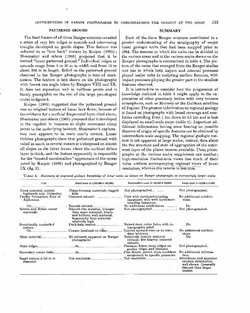
Each of the three Ranger missions contributed to agreater understanding of the stratigraphy of majorlunar geologic units that had been mapped prior to1964. The manner in which the units can be divided inthe various areas and at the various scales shown on theRanger photographs is summarized in table 4. The pic-ture of the moon that emerged from the- Ranger studieswas one in which both impact and internal processesplayed major roles in sculpting surface features, withimpact processes playing the greater part in the smallestfeatures observed.
It is instructive to consider how the progression ofknowledge outlined in table 4 might apply to the ex-ploration of other planetary bodies with very tenuousatmospheres, such as Mercury or the Galilean satellitesof Jupiter. The greatest information on regional geologyis found on photographs with broad coverage and reso-lution extending from 1 km down to 0.5 km and is bestdisplayed on small-scale maps (table 4). Important ad-ditional information having some bearing on possibletheories of origin of specific features can be obtained byintermediate-scale mapping. The regional geologic con-text is not apparent at large scales; instead, data aboutthe fine structure and state of aggregation of the outer-most layer of the planet become available. Thus, photo-graphs at the various scales supplement one another;high-resolution limited-area views lose much of theirvalue without accompanying regional views of lowerresolution, whereas the reverse is less true.
TABLE 4.—Summary of improved geologic knowledge of lunar units as shown on Ranger photographs at increasingly larger scales
Unit Small scale (1:1,000,000-1:250,000) Intermediate scale (1:100,000-1:50,000) Large scale (1:10,000-1:5,000)
Terra material, centralhighlands near Delambre.
Cayley Formation, floor ofAlphonsus.
DoSabine and Ritter crater
materials.
Structurally controlledcraters.
Do
Plains-forming materials; ruggedhills.
Cratered subunit
Not photographed Not photographed.
No additional subdivi-sions.
Smooth subunitSmooth rim material, younger
than mare material; lobateand bulbous wall material;hummocky floor material,relatively high.
Dark-halo craters
Unit with northeast-trendinglineations; unit with northwest-trending lineations.
No additional subdivisions Do.Not photographed Not photographed.
Craters localized on rilles.
Mare material-
Mare ridges
Secondary crater fields.
No subunits apparent on Rangerphotographs.
do
Small craters 5-50 m indiameter.
do
Not resolvable _
Raised rims; outer halos with notopographic relief.
Convex upward rims or no rims;deep interiors.
Relatively heavily crateredsubunit: less heavily crateredsubunit.
Plateaus; lobes; steep ridges ongentler ridges and plateaus.
Fine details permit more confidentassignment to specific primaries.
Not resolvable
Do.
No additional subdivi-sions.
Do.
Not photographed..
No additional informa-tion.
Abundance and apparentrandom distributionwell shown. Generallysharper than largercraters.

J14 CONTRIBUTIONS TO ASTROGEOLOGY
Combined with earlier telescopic views, the Rangerphotographs provided a nearly complete picture for oneside of the moon of the major types of features present,their distribution, and significant evidence bearing ontheir origin. Figure 6 shows in graphical form the typeof information conveyed with varying field of view andresolution in the photographs. For comparison, the
coverage and resolution expected to be achieved on the1974 Mariner mission to Mercury are also plotted. Fly-bys of the planets planned for the immediate future,such as the 1974 mission to Mercury, will have resolu-tions limited to about 100 m at best because of the highvelocities of the spacecraft with respect to the planets.
70
OI—
60
E
§50
K 40Q
t/5
5
',30
02 0
DC
Oo
o 10 —
§
..._,„. ,-.., — „._,,....,provinces— maria, terrae |
Earth based for Mercury -
Planetary stratigraphy, major units
I I
Earth based lunar telescopic data - 1 I
Major tectonic Ifeatures I
Major albedo variations, color provinces
Circumbasin deposits and structuresI I
Ranger VII, VIII, IX
Volcanic feature-cones, domes, calderas
Large crater distribution'
V iSmaller/tectonic features
Subunits'of. major' /"stratigraphic'units /
' Mariner mission to Mercury, 1974
Small crater^istribution /
Patterned ground /
Mass wasting .^Block distributions '^^ /
/.
Soi llstructure I
Overall crustal style
I I I1 cm 10 cm 1 m 10m 100 m 1 km
RESOLUTION
10 km 100 km 1000 km . .10,000 km
FIGURE 6.—Hierarchy of geologic features on a typical planetary surface plotted in terms of resolution and fractional coverageof planet achieved by a photographic system. Rangers VII, VIII, and IX compared with anticipated coverage of a plannedmission to Mercury in 1974. Limits of earth-based studies also shown. (After Masursky and.'others, 1970.)-

CONTRIBUTIONS OF RANGER PHOTOGRAPHS TO UNDERSTANDING THE GEOLOGY OF THE MOON J15
REFERENCES CITED
Cannon, P. J., and Rowan, L. C., 1971, Geologic map of the SabineEB region of the Moon: U.S. Geol. Survey Misc. Geol. Inv.Map 1-679. scale 1: 5,000.
Carr, M. H., 1964, Impact induced volcanism, in Astrogeol.Studies Ann. Prog. Kept, July 1, 1963-July 1, 1964, pt. A:U.S. Geol. Survey open-file report, p. 52-66.
. 1969, Geologic map of the Alphonsus region of the Moon:U.S. Geol. Survey Misc. Geol. Inv. map 1-599, scale1: 250,000.
Chapman, C. R., 1968, Interpretation of the diameter-frequencyrelation for lunar craters photographed by Rangers VII,VIII, and IX : Icarus, v. 8, no. 1, p. 6-10.
Evans, J. V., and Pettengill, G. H., 1963, The scattering behaviorof the moon at wavelengths of 3.6, 68, an 784 centimeters:Jour. Geophys. Research, v. 68, no. 2, p. 423-447.
Gault, D. E., Quaide, W. L., and Oberbeck, V. R., 1966, Inter-preting Ranger photographs from impact cratering studies,In Hess, W. N., Menzel, D. H., and O'Keefe, J. A., eds., Thenature of the lunar surface: Baltimore, Johns HopkinsPress, p. 125-140.
Hapke, B. W., 1964. Photometric and other laboratory studiesrelating to the lunar surface, in Salisbury, J. W., andGlaser, P. E., eds., Tlie lunar surface layer: New York,Academic Press, 532 p.
1966, Optical properties of the moon's surface, in Hess,W. N., Menzel, D. H., and O'Keefe, J. A., eds., The nature ofthe lunar surface: Baltimore, Johns Hopkins Press, p. 141-154.
Hartmann, W. K., 1968, Lunar crater counts VI: The youngcraters Tycho, Aristarchus and Copernicus: Univ. ArizonaLunar and Planetary Lab. Commun., v. 7, pt. 3, no. 119, p.145-156.
Heacock, R. L., Kuiper, G. P. Shoemaker, E. M., Urey, H. C., andWhitaker, E. A., 1965, Ranger VII; Part 2, Experimenters'analyses and interpretations: Calif. Inst. Technology, JetPropulsion Lab., Tech. Rept. 32-700,154 p.
1966, Ranger VIII and IX; Part 2, Experimenters'analyses and interpretations: Calif. Inst. Technology, JetPropulsion Lab., Tech. Rept. 32-800, 382 p.
Hess, W. N., Menzel, D. H., and O'Keefe, J. A., eds., 1966, Thenature of the lunar surface: Baltimore, Johns HopkinsPress, 320 p.
Howard, K. A., and Masursky, Harold, 1968, Geologic map of thePtolemaeus quadrangle of the moon : U.S. Geol. Survey Misc.Geol. Inv. Map 1-566, scale 1: 1,000,000.
Jaffe, I>. D., Alley, C. O., Batterson, S. A., Christensen, E. M.,Dwornik, S. E., Gault, D. E., Lucas, J. W., Muhleman, D. O.,Norton, R. H., Shoemaker, E. M., Steinbacher, R. H., Sut-ton, G. H., and Turkevich, A. L., 1969, Principal scienceresults from the Surveyor project, in Surveyor project finalreport; Part 2, Science results: Calif. Inst. Technology, JetPropulsion Lab. Tech. Rept. 32-1265, p. 15-20.
Kozyrev, N. A., 1962, Physical observations of the lunar sur-face, in Kopal Zdenek, ed., Physics and astronomy of themoon : London, Academic Press, p. 361-383.
Kuiper, G. P., 1965, Intepretation of Ranger VII records, inRanger VII; Part 2, Experimenters' analyses and interpre-tations : Calif. Inst. Technology, Jet Propulsion Lab. Tech.Rept. 32-700, p. 9-74.
1966, The surface structure of the moon, in Hess, W. N.,Menzel, D. H., and O'Keefe, Jr. A., eds., The nature of thelunar surface: Baltimore, Johns Hopkins Press, p. 99-105.
Kuiper, G. P., Strom, R. G., and LePoole, R. S., 1966, Interpre-tation of the Ranger records, in Ranger VIII and IX ; Part2, Experimenters' analyses and interpretations: Calif. Inst.Technology, Jet Propulsion Lab. Tech. Rept. 32-800, p. 35-248.
Masursky, H., Batson, R., Borgeson, W., Carr, M., McCauley, J.,Milton, D., Wildey, R., Wilhelms, D., Murray, B., Horowitz,N., Leighton R., Sharp, R., Thompson, W., Briggs, G.,Chandeysson, P., Shipley, E., Sagan, C., Pollack, J., Leder-berg, J., Levinthal, E., Hartmaun, W., McCord, T., Smith,B., Davies, M., de Vaucouleurs, G., and Leovy, C., 1970, Tele-vision experiment for Mariner Mars 1971: Icarus, v. 12, no.1, p. 10-45.
McCauley, J. F., 1968, Geologic results of lunar precursor probes:Am. Inst. Aeronautics and Astronautics Jour., v. 6, no. 1,p. 1991-1996.
1969, Geologic map of the Alphonsus GA region of themoon: U.S. Geol. Survey Misc. Geol. Inv. Map 1-586, scale1: 50,000.
McGillem, C. D., and Miller, B. D., 1962, Lunar surface rough-ness from crater statistics: Jour. Geophys. Research, v. 67,no. 12, p. 4787-4794.
Milton, D. J., 1968, Geologic map of the Thebphilus quadrangleof the moon: U.S. Geol. Survey Misc. Geol. Inv. Map 1-546,scale 1:1,000,000.
Minnaert, M. G. J., 1961, Photometry of the moon, Chapter 6 inKuiper, G. P., and Middlehurst, B. M., eds., Planets and satel-lites, volume 3 of The solar system : Chicago, Univ. ChicagoPress, p. 213-248.
Moore, H. J., 1964, Density of small craters on the lunar surface,in Astrogeol. Studies Ann. Prog. Rept., August 1962-July1963, pt. D : U.S. Geol. Survey open-file report, p. 34-51.
1970, Estimates of the mechanical properties of lunar sur-face using tracks and secondary impact craters produced byblocks and boulders: U.S. Geol. Survey open-file report,65 p.
Morris, E. C., and Wilhelms, D. E., 1967, Geologic map of theJulius Caesar quadrangle of the Moon: U.S. Geol. SurveyMisc. Geol. Inr. Map 1-510, scale 1:1,000,000.
Mutch, T. A., 1970, Geology of the moon : Princeton, N. J., Prince-ton Univ. Press, 324 p.
National Aeronautics and Space Administration, 1964, Camera"A" Series, Ranger VII photographs of the moon: U.S.Natl. Aeronautics and Space Adm. Spec. Pub. 61, 17 p., 199pis.
— 1965a, Camera "B" Series, Ranger VII photographs ofthe moon: U.S. Natl. Aeronautics and Space Adm. Spec.Pub. 62,17 p., 199 pis.
• 1965b, Camera "P" Series, Ranger VII photographs of themoon: U.S. Natl. Aeronautics and Space Adm. Spec. Pub.63, 27 p., 200 pis.
1966a, Cameras "A", "B", and "P" Series, Ranger VIIIphotographs of the moon: U.S. Natl. Aeronautics and SpaceAdm. Spec. Pub. Ill, 17 p., 170 pis.
1966b, Cameras "A", "B", and "P" Series, Banger IXphotographs of the moon: U.S. Natl. Aeronautics and SpaceAdm. Spec. Pub. 112,17 p., 170 pis.
O'Keefe, J. A., 1966, Lunar ash flows, in Hess, W. N., Menzel,D. H., and O'Keefe, J. A., eds., The nature of the lunar sur-face : Baltimore, Johns Hopkins Press, p. 259-266.
Quaide, W. L., and Oberbeck, V. R., 1968, Thickness determina-tions of the lunar surface layer from lunar impact craters -•Jour. Geophys. Research, v. 73, no. 16, p. 5247.

J16 CONTRIBUTIONS TO ASTROGEOLOGY
Shoemaker, E. M., 1966, .Preliminary analysis of the fine struc-ture of the lunar surface in Mare Cognitum, w Hess, W. N.,Menzel, D. H., and O'Keefe, J. A., eds., The nature of thelunar surface: Baltimore, Johns Hopkins Press, p. 23-77.
Shoemaker, E. M., Alderman, J. D., Borgeson, W. T., Carr, M. H.,Lugn, R. V., McCauley, J. F., Milton, D. J., Moore, H. J.,Schinitt, H. H., Trask, N. J., Wilhelms, D. E., and Wu, S. C.C., 1966, Progress in the analysis of the fine structure andgeology of the lunar surface from the Ranger VIII and IXphotographs, in Ranger VIII and IX; Part 2, Experiment-ers' analyses and interpretations: Calif. Inst. Technology,Jet Propulsion Tech. Kept. 32-800, p. 249-338.
Shoemaker, E. M., and Hackman, R. J., 1962, Stratigraphic basisfor a lunar time scale, in Kopal, Zdenek, and Mikhailov,Z. K., eds., The moon—Internal. Astron. Union Symposium14, Leningrad, 1960: London, Academic Press, p. 289-300.
Titley, S. R., 1968, Preliminary geologic map of the Bonpland Hregion of the moon : U.S. Geol. Survey open-file report, scale1:100,000.
1971, Geologic map of the Bonpland PQC region of themoon: U.S. Geol. Survey Misc. Geol. Inv. Map 1-678.
Trask, N. J., 1967, Distribution of lunar craters according tomorphology from Ranger VIII and IX photographs: Icarus,v. 6, no. 2, p. 270-276.
1969, Geologic map of the Sabine DM region of the moon:U.S. Geol. Survey Misc. Geol. Inv. Map 1-594, scale 1: 50,000.
U.S. Geological Survey, 1971, Geologic map of the Bonpland Hregion of the moon: U.S. Geol. Survey Misc. Geol. Inv. Map1-693, scale 1:100,000.
Urey, H. C., 1965, Observations on the Ranger VII pictures, inRanger VII; Part 2, Experimenters' analyses and interpre-tations: California Inst. Technology, Jet Propulsion Lab.Tech. Rept. 32-700, .p. 135-148.
Wilhelms, D. E., 1970, Summary of lunar stratigraphy—tele-scopic observations: U.S. Geol. Survey Prof. Paper 599-1?,47 p.
Wilshire, H. G., 1967, Preliminary photogeologic map of theSabine region of the moon, in Astrogeol. Studies Ann. Prog.Rept. July 1, 1965-July 1, 1966: U.S. Geol. Survey open-filereport, scale 1: 250,000, map supp.

Contributions to
Astrogeology,1967-71G E O L O G I C A L S U R V E Y P R O F E S S I O N A L P A P E R 5 9 9
This volume was published
as separate chapters A—

UNITED STATES DEPARTMENT OF THE INTERIOR
ROGERS C. B. MORTON, Secretary
GEOLOGICAL SURVEY
V. E. McKelvey, Director

CONTENTS
[Letters designate the separately published chapters]
(A) Seismic detection of near-surface cavities, by Joel S. Watkins, Richard H. Godson, and Kenneth Watson.(B) Photoclinometry from spacecraft images, by Kenneth Watson.(C) Structural geology of the Henbury meteorite craters, Northern Territory, Australia, by Daniel J. Milton.(D) Detection of SH-type seismic shear waves by means of angular accelerometers, by James H. Whitcomb.(E) A photoelectric-photographic study of the normal albedo of the moon, by Howard A. Pohn and Robert L. Wildey.(P) Summary of lunar stratigraphy—telescopic observations, by Don E. Wilhelms.(G) Lunar terrain mapping and relative-roughness analysis, by Lawrence C. Rowan, John F. McCauley, and Esther A. Holm.(H) Geology of the Sierra Madera cryptoexplosion structure, Pecos County, Texas, by H. G. Wilshire, T. W. Offield, Keith A.
Howard, and David Cummings.(I) Geology of the lunar crater volcanic field, Nye County, Nevada, by David H. Scott and N. J. Trask.(J) The contributions of Ranger photographs to understanding the geology of the moon, by N. J. Trask.
U. S. GOVERNMENT PRINTING OFFICE : 1972 O - 460-198
A