GCSE COASTS. 1a CONSTRUCTIVE DESTRUCTIVE WAVES 1b COASTAL EROSION.

Waves
1. Out at sea the wind tugs at the surface of the water causing the wave shape to
move. Within a wave water particles move in a circular motion
2. When a wave moves into shallow water near the coast, friction causes the waves
to slow at the base. Friction causes the waves to break as the top of the wave is
moving faster than the bottom.
3. As the waves break onto the shore it is called the swash
4. The beach will absorb the energy of the wave and then the water drains back
down the beach – this is called the backwash.
Constructive Waves
These build up the beach - deposition
The swash is stronger than backwash
They form gently sloping beaches
6-8 waves per minute
Also known as ‘spilling waves’
Wave Action
Waves are caused by the wind dragging over the surface of the water.
The length of water the wind blows over is called the fetch
Wave strength is determined by fetch length and time wind is blowing
The stronger the wind, the longer is blows for and the longer its fetch the larger the
waves will be.
The prevailing wind is the most dominant direction that the wind comes from. The South
Coasts prevailing wind comes from the South West across the Atlantic Ocean.
The Coastal Zone

Wave refraction
Waves bend when they come across
resistance as they move towards the
coast. As waves reach a bay, the
headlands will causes friction so the
waves will slow here, but in the centre
of the wave they do not come across
friction so they are moving faster
until they hit the coast, this looks like
the waves are a semicircle shape. The
bending of the waves is called wave
refraction.
Coastal Processes
Erosion
Abrasion: This is when broken rock fragments are hurled at a cliff by waves and break off more
pieces of rock like sandpaper
Hydraulic Action/Power: When waves hit the cliffs and air and water are trapped and
compressed into cracks. When the sea moves away the air expands, weakening the rocks and
enlarges cracks
Corrosion/Solution: This is the chemical action of the sea on rocks. Salt in the seawater slowly
dissolves the cliffs. The material produced is carried away by the process of solution.
Attrition: Particles carried by the wave’s crash against each other and are broken up into
smaller rounder particles.
Destructive Waves
These erode material from the beach
The backwash is stronger than swash
High steep waves
Steeply sloping beaches
13-15 waves per minute
Also known as ‘plunging’ waves
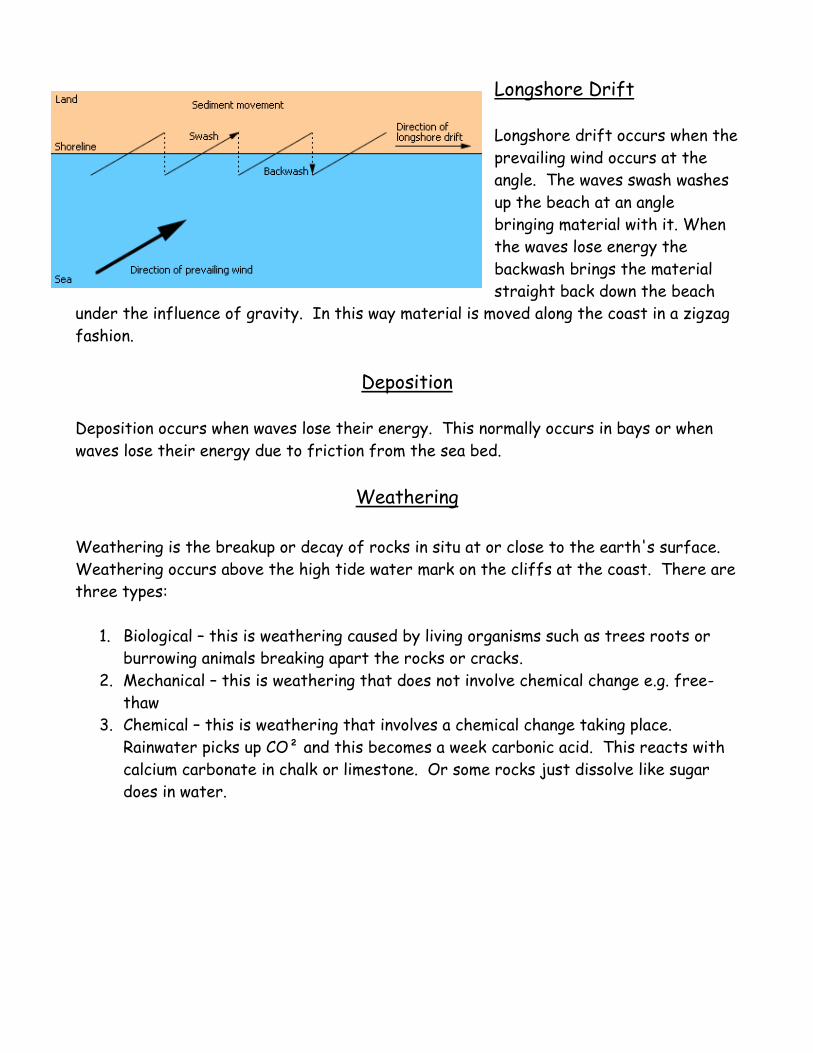
Longshore Drift
Longshore drift occurs when the
prevailing wind occurs at the
angle. The waves swash washes
up the beach at an angle
bringing material with it. When
the waves lose energy the
backwash brings the material
straight back down the beach
under the influence of gravity. In this way material is moved along the coast in a zigzag
fashion.
Deposition
Deposition occurs when waves lose their energy. This normally occurs in bays or when
waves lose their energy due to friction from the sea bed.
Weathering
Weathering is the breakup or decay of rocks in situ at or close to the earth's surface.
Weathering occurs above the high tide water mark on the cliffs at the coast. There are
three types:
1. Biological – this is weathering caused by living organisms such as trees roots or
burrowing animals breaking apart the rocks or cracks.
2. Mechanical – this is weathering that does not involve chemical change e.g. free-
thaw
3. Chemical – this is weathering that involves a chemical change taking place.
Rainwater picks up CO² and this becomes a week carbonic acid. This reacts with
calcium carbonate in chalk or limestone. Or some rocks just dissolve like sugar
does in water.

Freeze-thaw weathering (Mechanical)
Water repeatedly freezes and thaws in cracks or holes in the cliff. Water will expand
by approx. 9% and if it’s confined in a small space this stresses the rock and widens and
deepens cracks. Rocks may break apart and fall to the bottom of the cliff and collects
as scree.
Erosional Landforms
1. Wave Cut Notch
1. Caves, Arches and Stacks
1. Waves attack the cliff between
the high tide and low tide mark
will cause a wave-cut notch to
be formed at the bottom.
2. As the notch grows inland the
cliff above creates an overhang.
Eventually the cliff collapses
and the debris is then removed
by the sea. This process means
the cliff face gradually retreats
and creates a wave cut platform
seen at low tide.
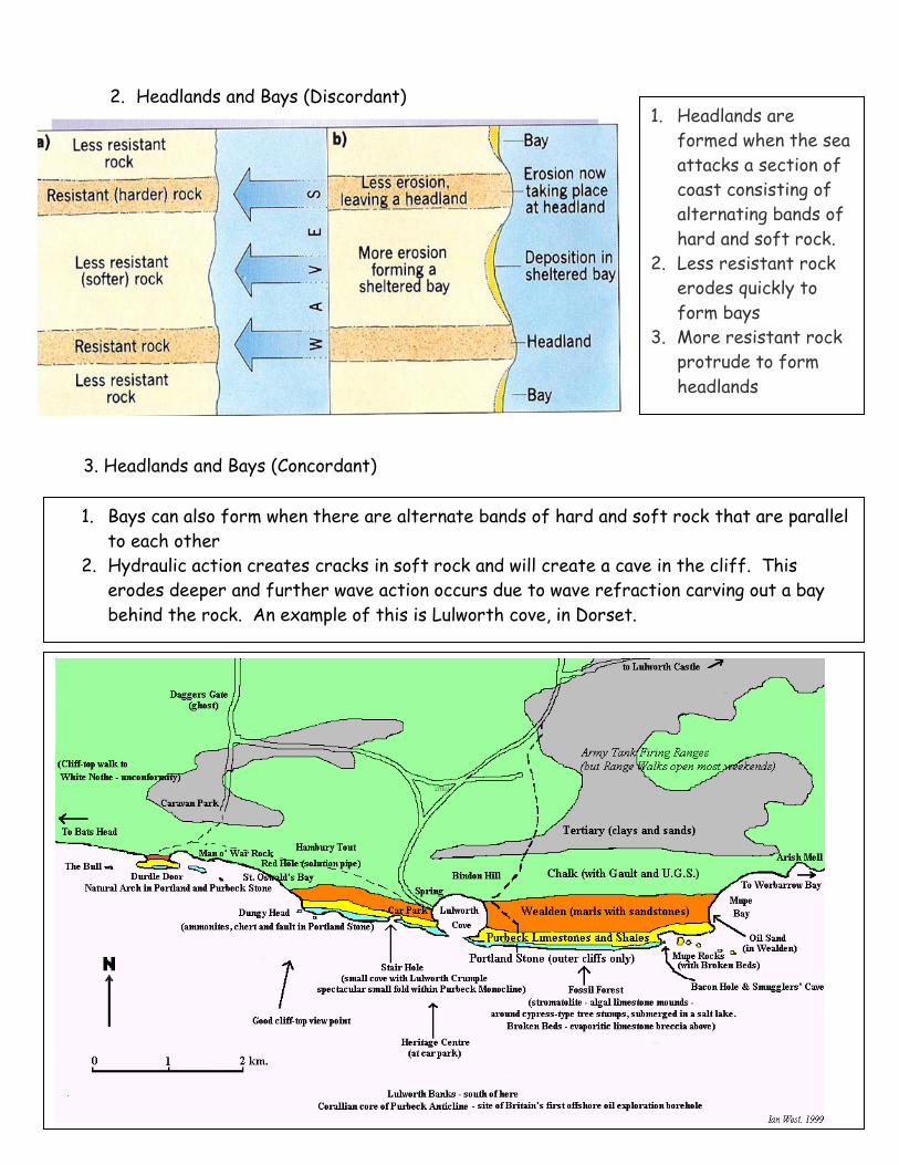
2. Headlands and Bays (Discordant)
3. Headlands and Bays (Concordant)
1. Headlands are
formed when the sea
attacks a section of
coast consisting of
alternating bands of
hard and soft rock.
2. Less resistant rock
erodes quickly to
form bays
3. More resistant rock
protrude to form
headlands
1. Bays can also form when there are alternate bands of hard and soft rock that are parallel
to each other
2. Hydraulic action creates cracks in soft rock and will create a cave in the cliff. This
erodes deeper and further wave action occurs due to wave refraction carving out a bay
behind the rock. An example of this is Lulworth cove, in Dorset.

4. Caves, Arches and Stacks
Wave energy is
concentrated on
headlands because
they jut out to sea.
Cracks are pounded by
the sea via hydraulic
action and abrasion
creating caves. When
these erode through
the headland they
create arches, which
eventually collapse
leaving a stack. When
this collapses it
creates a stump.

Depositional Landforms
1. Beaches
Constructive waves help build beaches by depositing material when waves lose energy.
2. Spits
3. Tombolos
Tombolos are formed when a spit continues to
grow outwards joining land to an offshore island.
e.g. Chesil Beach joins the South Dorset coast to
the Isle of Portland.
Longshore Drift moves material along a
coastline in the direction of the prevailing
wind.
Deposition occurs at the bend of a
coastline where it changes shape.
Deposited material may accumulate away
from the coast into the open sea until a
long ridge of sand is built up
If winds come from the opposite
direction the end of the spit may become
recurved like a hook
This may also occur where a river meets
the coast and a salt marsh may develop
behind the spit as it is sheltered.
a) Smallest material is
deposited nearer the
sea
b) Heavier material is
deposited further up
the beach
c) The natural ridge on
the beach is known
as the berm.

4. Bars
A bar is formed when a spit joins to headland.
A Lagoon will form behind if there is a small
river flowing into it. An example is Slapton Ley
in Devon.

Hurst Castle Spit
Hurst Castle spit is on the
Hampshire coast close to the city
of Southampton. Henry VIII
built a castle near the top of the
spit to help defend England from
possible invasions. Behind the
spit is Keyhaven marshes a Site
of Special Scientific Interest
(SSSI).
Shoreline Management Plans (SMPs)
The coastline of England and Wales has been divided into a number of self-contained
sediment cells. The SMP has been developed for each area, which details the natural
processes, environmental considerations and human uses.
Hold the line: This means
taking action to keep the line
of the coast as it is now e.g.
sea wall
Advance the line: This means
to put in greater protection
by increasing the size of the
beach for example.
Managed retreat: Allow the
land to flood and erode.
This option can be taken if
the land is of low value and it
would cost more to protect
it than what it is worth. A
cost benefit analysis would
help make this decision.

Coastal Management
Successful management of coastal areas depends on understanding the differing
interests of those who want to use coastal land in different ways.
Hard Engineering schemes are made using concrete or steel. They are manmade and
usually cost a lot to build. They work against natural processes.
Soft engineering schemes work with natural processes and
usually are cheaper. They look natural but don’t last as long as
hard engineering schemes.

Case Study: Holderness Coast -
Mappleton
Mappleton is a small village which by 1990 was
under threat of becoming lost to erosion. It is
located on the Yorkshire coastline between
the Humber estuary and Bridlington. The
B1242 is a vital link road along the coast and it
would have been too expensive to find a new
route for it. The government therefore spent
£2 million pounds trying to save the village
ISSUES
Coastline is 3-4km further inland than in
Roman times. 29 villages lost to sea in
past thousand years. Erosion occurring at
2m per year – the fastest eroding
coastline in Europe
SOLUTIONS
2 rock groynes were built from Granite imported
from Norway.
IMPACTS
Groynes have reduced longshore drift and
stopped coastal erosion at Mappleton but have
caused problems further south
Cliffs are no longer protected by a beach and at
high tide waves reach the base of the cliff
increasing the rate of erosion to 10m a year!
Remember Sue Earle’s farm!
CAUSES
Cliffs made of unconsolidated Bolder Clay
and sand which are easy to erode.
Winds from North and North East
causing erosion due to large fetch
Longshore drift occurs from North to
South along the Holderness Coast

Slumping
If cliffs are made of sand or clay they are prone to
slumping. If a cliff has a layer of clay with sand on
top, rain water will seep down though the layer of sand
and then saturates the base of the sand between this
layer and the clay layer. This reduces friction and
causes the sand to be unstable and move down slope
due to gravity as large chunks. With clay cliffs, they
dry out and crack in summer. When it then rains water
seeps down the cracks and make the cliff unstable so
it then slumps downwards.
Sea Level Rise
There are two ways that sea levels change:
1. The sea level changes itself globally = Eustatic
2. The land changes locally = Isostatic
1a) Melting global ice is due to warming temperatures means sea levels rise as there's
more water in the sea. Decreasing world temperatures = ice, which means lower
sea levels as the water is stored as ice.
1b) If global temperatures increase the seas get warmer. This means that the water
expands so the sea level rises = Thermal Expansion
2a) Isostatic rebound/uplift: This is where ice melts on the land, so the weight on the
land disappears so the land rises like a sponge would after being compressed.
When Scotland had ice on it, it sank due to the weight, so sea levels looked like
they rose and the south of England rose so the sea level looked like they got
lower. Its like a sea saw.
2b) When an earthquake happens, the land changes and can be forced up or down, so
this means that sea levels can look either lower or higher. e.g. After the 2004
earthquake parts of Indonesia were raised by 6 metres

2c) When rivers meet the sea at the mouth, the land is flatter. This means that the
water loses its energy and deposition occurs. This means that sediment builds up
so the level of the river changes and rises.
Consequences of sea level change - Coastal flooding in Norfolk
Over the last 15 years global average sea levels have risen by 3mm a year. This could
increase by 28-43cm by the end of this century!
London flooding
If The Thames Barrier failed and London flooded these
are consequences:
- London is world centre for the banking and finance
industry. It creates 40% of the UK's GNP.
- Insurance industry would have huge claims being
made for damaged property.
- Transport networks would be flooded including over-ground and tube networks.
- London's population is approximately 7.5 million
- Power and water supplies affected
- Historic buildings would be flooded e.g. Houses of Parliament
- London makes £16 billion from tourism every year

Cost Benefit Analysis
The cost benefit analysis looks at whether a scheme is worth putting in place for the
amount of property or business it will protect. You divide the cost of property by the
cost of the defence (lasting for 100 years). The higher the value the most cost
effective the method is.
Limitations:
Uses the average
cost of a defence
method and average
cost of property
Roads are not taken
into account for the
value of the land a
scheme would
protect

Salt Marshes
Pioneer plant: the first plant species to colonise an area that is well adapted to living in a
harsh environment e.g. salt tolerant
Vegetation succession: a sequence of vegetation species colonising an environment
Keyhaven Marshes
These marshes are in the lee of Hurst Castle spit in
Hampshire. It supports a range of habitats including
grassland, scrub, salt marsh and reed beds. This variety
of habitats accounts for a rich diversity of wildlife in the
area. Examples include: Cordgrass, sea lavender, Oystercatcher and Ringed Plover
(birds), Common Blue butterfly and the Wold spider.
It is under threat because:
a) The marsh is retreating by up to 6m a year. It is being squeezed between the low
sea wall and the encroaching sea.
b) The spit is being breached during severe storms. The 1989 storm exposed 50-80m
of the spit to the sea and it was eroded in less than 3 months.
c) More people are visiting the marshes. They trample on the marshes, moor
boats in the creeks and causes pollution.
How are Keyhaven marshes being managed in a sustainable way?
1. In 1996 rock armour and beach nourishment were used to increase the height and
width of the spit to try and stop it being breached. £5 million was spent on this
and since then the spit has not been breached and the marshes seem safe
2. The marshes have been made a Site of Special scientific Interest (SSSI) and
part of it is now a National Nature Reserve. This has been done to protect the
wildfowl and wading birds and so that the area can be carefully monitored and
managed to main the rich biodiversity. Access is limited and development
restricted.
3. In the future the low sea wall may be removed and the land allowed to flood if sea
levels continue to rise.