The Clay Research Group The Clay Research The Clay ... 69.pdf · electrokinesis to stabilise clay...
9
The Clay Research Group February 2011 RESEARCH AREAS Climate Change Data Analysis Electrical Resistivity Tomography Time Domain Reflectometry BioSciences Ground Movement Soil Testing Techniques Telemetry Numerical Modelling Ground Remediation Techniques Risk Analysis Mapping Software Analysis Tools
Transcript of The Clay Research Group The Clay Research The Clay ... 69.pdf · electrokinesis to stabilise clay...
The Clay Research Group Issue 69 – February 2011 – Pag
K
The Clay Research Group
Monthly Bulletin
TheClay Research
Group
February 2011
RESEARCH AREAS
Climate Change Data Analysis Electrical Resistivity Tomography
Time Domain Reflectometry BioSciences Ground Movement
Soil Testing Techniques Telemetry Numerical Modelling
Ground Remediation Techniques Risk Analysis
Mapping Software Analysis Tools
The Clay Research Group Issue 69 – February 2011 – Page 1
K
The annual conference will be held at Aston onThursday, 12th May this year and we are asking forpapers from the industry on topics associated withsubsidence - soils, investigations, insurance, trees,risk management and so forth.
Please send to [email protected] or toDr Sadeghzadeh at Aston ([email protected]),
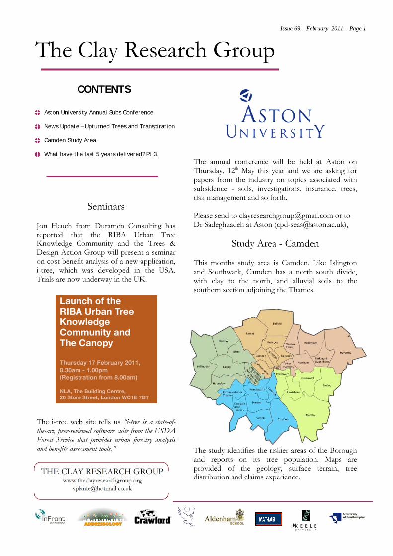
Study Area - Camden
This months study area is Camden. Like Islingtonand Southwark, Camden has a north south divide,with clay to the north, and alluvial soils to thesouthern section adjoining the Thames.
The study identifies the riskier areas of the Boroughand reports on its tree population. Maps areprovided of the geology, surface terrain, treedistribution and claims experience.
CONTENTS
Aston University Annual Subs Conference
News Update – Upturned Trees and Transpiration
Camden Study Area
What have the last 5 years delivered? Pt 3.
Seminars
Jon Heuch from Duramen Consulting hasreported that the RIBA Urban TreeKnowledge Community and the Trees &Design Action Group will present a seminaron cost-benefit analysis of a new application,i-tree, which was developed in the USA.Trials are now underway in the UK.
The i-tree web site tells us “i-tree is a state-of-the-art, peer-reviewed software suite from the USDAForest Service that provides urban forestry analysisand benefits assessment tools.”
The Clay Research Group Issue 69 – February 2011 – Page 2
K
.
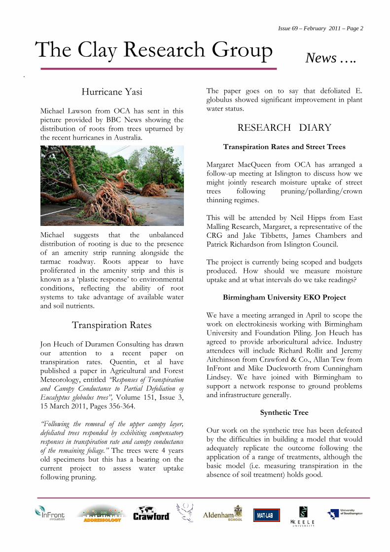
Hurricane Yasi
Michael Lawson from OCA has sent in thispicture provided by BBC News showing thedistribution of roots from trees upturned bythe recent hurricanes in Australia.
Michael suggests that the unbalanceddistribution of rooting is due to the presenceof an amenity strip running alongside thetarmac roadway. Roots appear to haveproliferated in the amenity strip and this isknown as a ‘plastic response’ to environmentalconditions, reflecting the ability of rootsystems to take advantage of available waterand soil nutrients.
Transpiration Rates
Jon Heuch of Duramen Consulting has drawnour attention to a recent paper ontranspiration rates. Quentin, et al havepublished a paper in Agricultural and ForestMeteorology, entitled “Responses of Transpirationand Canopy Conductance to Partial Defoliation ofEucalyptus globulus trees”, Volume 151, Issue 3,15 March 2011, Pages 356-364.
“Following the removal of the upper canopy layer,defoliated trees responded by exhibiting compensatoryresponses in transpiration rate and canopy conductanceof the remaining foliage.” The trees were 4 yearsold specimens but this has a bearing on thecurrent project to assess water uptakefollowing pruning.
The paper goes on to say that defoliated E.globulus showed significant improvement in plantwater status.
RESEARCH DIARY
Transpiration Rates and Street Trees
Margaret MacQueen from OCA has arranged afollow-up meeting at Islington to discuss how wemight jointly research moisture uptake of streettrees following pruning/pollarding/crownthinning regimes.
This will be attended by Neil Hipps from EastMalling Research, Margaret, a representative of theCRG and Jake Tibbetts, James Chambers andPatrick Richardson from Islington Council.
The project is currently being scoped and budgetsproduced. How should we measure moistureuptake and at what intervals do we take readings?
Birmingham University EKO Project
We have a meeting arranged in April to scope thework on electrokinesis working with BirminghamUniversity and Foundation Piling. Jon Heuch hasagreed to provide arboricultural advice. Industryattendees will include Richard Rollit and JeremyAitchinson from Crawford & Co., Allan Tew fromInFront and Mike Duckworth from CunninghamLindsey. We have joined with Birmingham tosupport a network response to ground problemsand infrastructure generally.
Synthetic Tree
Our work on the synthetic tree has been defeatedby the difficulties in building a model that wouldadequately replicate the outcome following theapplication of a range of treatments, although thebasic model (i.e. measuring transpiration in theabsence of soil treatment) holds good.
News ….
The Clay Research Group Issue 69 – February 2011 – Page 3
K
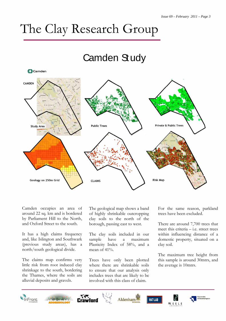
Camden occupies an area ofaround 22 sq. km and is borderedby Parliament Hill to the North,and Oxford Street to the south.
It has a high claims frequencyand, like Islington and Southwark(previous study areas), has anorth/south geological divide.
The claims map confirms verylittle risk from root induced clayshrinkage to the south, borderingthe Thames, where the soils arealluvial deposits and gravels.
Camden Study
For the same reason, parklandtrees have been excluded.
There are around 7,700 trees thatmeet this criteria – i.e. street treeswithin influencing distance of adomestic property, situated on aclay soil.
The maximum tree height fromthis sample is around 30mtrs, andthe average is 10mtrs.
The geological map shows a bandof highly shrinkable outcroppingclay soils to the north of theborough, passing east to west.
The clay soils included in oursample have a maximumPlasticity Index of 58%, and amean of 41%.
Trees have only been plottedwhere there are shrinkable soilsto ensure that our analysis onlyincludes trees that are likely to beinvolved with this class of claim.
The Clay Research Group Issue 69 – February 2011 – Page 4
K
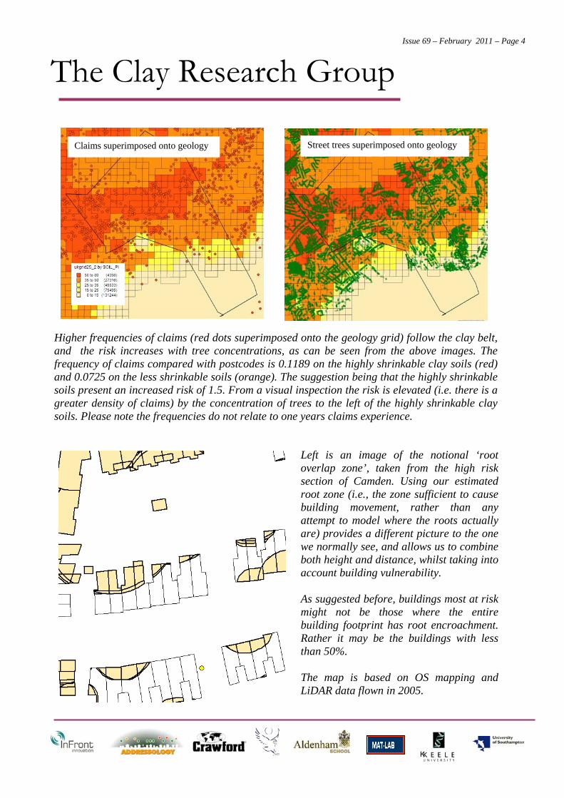
Higher frequencies of claims (red dots superimposed onto the geology grid) follow the clay belt,and the risk increases with tree concentrations, as can be seen from the above images. Thefrequency of claims compared with postcodes is 0.1189 on the highly shrinkable clay soils (red)and 0.0725 on the less shrinkable soils (orange). The suggestion being that the highly shrinkablesoils present an increased risk of 1.5. From a visual inspection the risk is elevated (i.e. there is agreater density of claims) by the concentration of trees to the left of the highly shrinkable claysoils. Please note the frequencies do not relate to one years claims experience.
Left is an image of the notional ‘rootoverlap zone’, taken from the high risksection of Camden. Using our estimatedroot zone (i.e., the zone sufficient to causebuilding movement, rather than anyattempt to model where the roots actuallyare) provides a different picture to the onewe normally see, and allows us to combineboth height and distance, whilst taking intoaccount building vulnerability.
As suggested before, buildings most at riskmight not be those where the entirebuilding footprint has root encroachment.Rather it may be the buildings with lessthan 50%.
The map is based on OS mapping andLiDAR data flown in 2005.
Claims superimposed onto geology Street trees superimposed onto geology
The Clay Research Group Issue 69 – February 2011 – Page 5
K
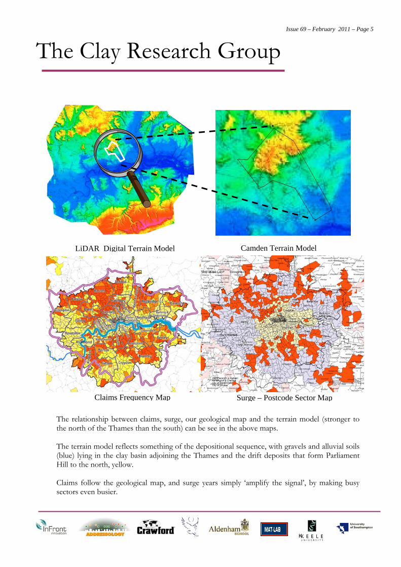
The relationship between claims, surge, our geological map and the terrain model (stronger tothe north of the Thames than the south) can be see in the above maps.
The terrain model reflects something of the depositional sequence, with gravels and alluvial soils(blue) lying in the clay basin adjoining the Thames and the drift deposits that form ParliamentHill to the north, yellow.
Claims follow the geological map, and surge years simply ‘amplify the signal’, by making busysectors even busier.
LiDAR Digital Terrain Model Camden Terrain Model
Surge – Postcode Sector MapClaims Frequency Map
The Clay Research Group Issue 69 – February 2011 – Page 6
K
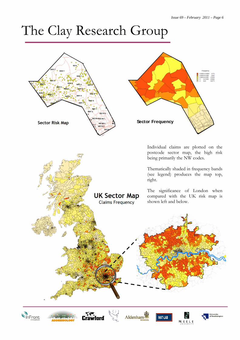
Sector Frequency
Individual claims are plotted on thepostcode sector map, the high riskbeing primarily the NW codes.
Thematically shaded in frequency bands(see legend) produces the map top,right.
The significance of London whencompared with the UK risk map isshown left and below.
The Clay Research Group Issue 69 – February 2011 – Page 7
K
What have 5 Years of Research Delivered? Part 3.
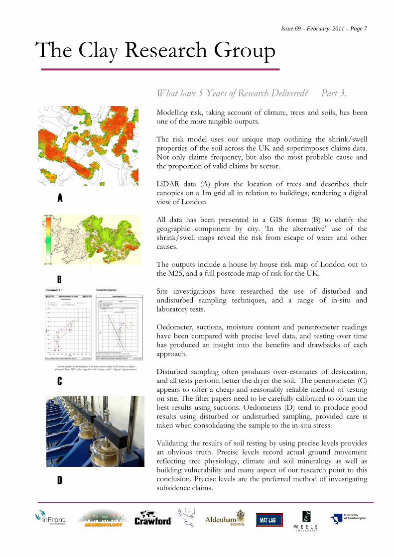
Modelling risk, taking account of climate, trees and soils, has beenone of the more tangible outputs.
The risk model uses our unique map outlining the shrink/swellproperties of the soil across the UK and superimposes claims data.Not only claims frequency, but also the most probable cause andthe proportion of valid claims by sector.
LiDAR data (A) plots the location of trees and describes theircanopies on a 1m grid all in relation to buildings, rendering a digitalview of London.
All data has been presented in a GIS format (B) to clarify thegeographic component by city. ‘In the alternative’ use of theshrink/swell maps reveal the risk from escape of water and othercauses.
The outputs include a house-by-house risk map of London out tothe M25, and a full postcode map of risk for the UK.
Site investigations have researched the use of disturbed andundisturbed sampling techniques, and a range of in-situ andlaboratory tests.
Oedometer, suctions, moisture content and penetrometer readingshave been compared with precise level data, and testing over timehas produced an insight into the benefits and drawbacks of eachapproach.
Disturbed sampling often produces over-estimates of desiccation,and all tests perform better the dryer the soil. The penetrometer (C)appears to offer a cheap and reasonably reliable method of testingon site. The filter papers need to be carefully calibrated to obtain thebest results using suctions. Oedometers (D) tend to produce goodresults using disturbed or undisturbed sampling, provided care istaken when consolidating the sample to the in-situ stress.
Validating the results of soil testing by using precise levels providesan obvious truth. Precise levels record actual ground movementreflecting tree physiology, climate and soil mineralogy as well asbuilding vulnerability and many aspect of our research point to thisconclusion. Precise levels are the preferred method of investigatingsubsidence claims.
A
B
C
D
The Clay Research Group Issue 69 – February 2011 – Page 8
K
What have 5 Years of Research Delivered? Part 2.
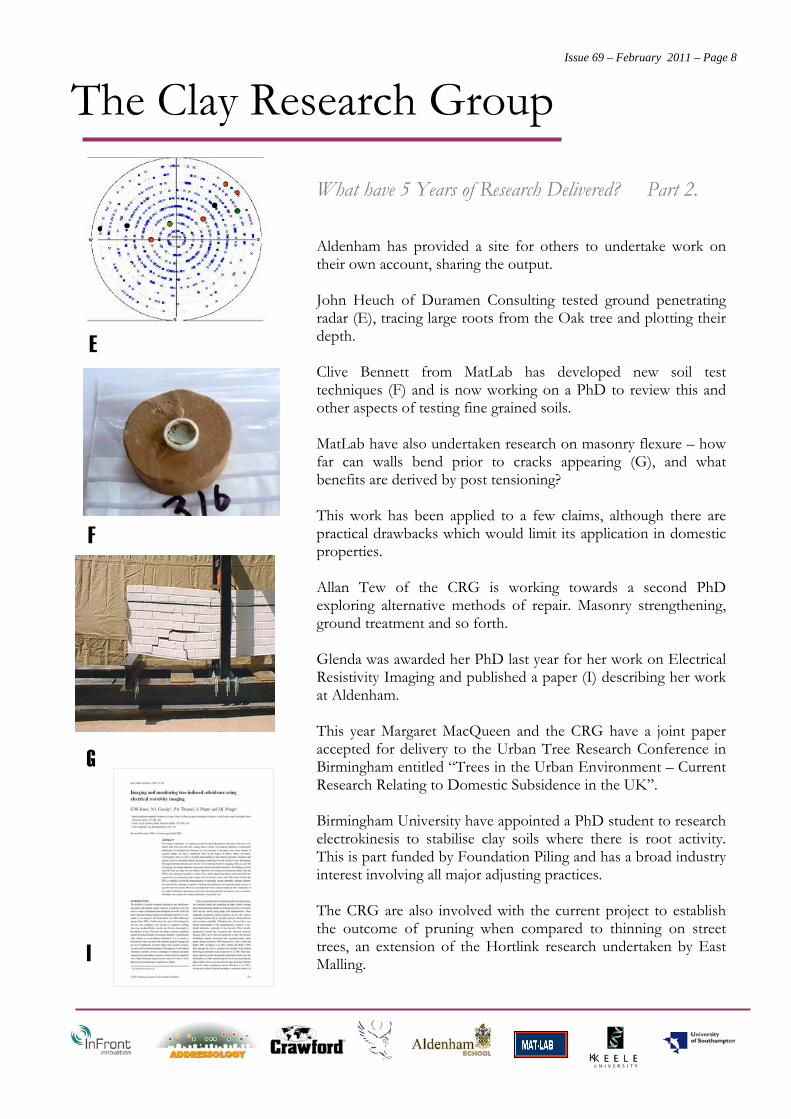
Aldenham has provided a site for others to undertake work ontheir own account, sharing the output.
John Heuch of Duramen Consulting tested ground penetratingradar (E), tracing large roots from the Oak tree and plotting theirdepth.
Clive Bennett from MatLab has developed new soil testtechniques (F) and is now working on a PhD to review this andother aspects of testing fine grained soils.
MatLab have also undertaken research on masonry flexure – howfar can walls bend prior to cracks appearing (G), and whatbenefits are derived by post tensioning?
This work has been applied to a few claims, although there arepractical drawbacks which would limit its application in domesticproperties.
Allan Tew of the CRG is working towards a second PhDexploring alternative methods of repair. Masonry strengthening,ground treatment and so forth.
Glenda was awarded her PhD last year for her work on ElectricalResistivity Imaging and published a paper (I) describing her workat Aldenham.
This year Margaret MacQueen and the CRG have a joint paperaccepted for delivery to the Urban Tree Research Conference inBirmingham entitled “Trees in the Urban Environment – CurrentResearch Relating to Domestic Subsidence in the UK”.
Birmingham University have appointed a PhD student to researchelectrokinesis to stabilise clay soils where there is root activity.This is part funded by Foundation Piling and has a broad industryinterest involving all major adjusting practices.
The CRG are also involved with the current project to establishthe outcome of pruning when compared to thinning on streettrees, an extension of the Hortlink research undertaken by EastMalling.
E
F
G
I