The Bushveld Complex in the Context of theThe Bushveld ... Saager Part.pdf•The Kaapvaal Craton is...
22
The Bushveld Complex in the Context of the The Bushveld Complex in the Context of the Geology of South Africa’s Kaapvaal Craton
Transcript of The Bushveld Complex in the Context of theThe Bushveld ... Saager Part.pdf•The Kaapvaal Craton is...

The Bushveld Complex in the Context of theThe Bushveld Complex in the Context of the Geology of South Africa’s Kaapvaal Craton

•The Kaapvaal Craton is a fragment of the Earth‘s crust and underlies almost half of South Africa. To the North it is separated from the Zimbabwe Craton by the highly metamorphosed rocks of the Limpopo Belt.• The Craton began to form about 3‘600 MaThe Craton began to form about 3 600 Ma ago and suffered little deformation for more than 2‘600 Ma. However the Archaean basement is now largely covered by younger
krocks • The craton is the host of the world‘s number one resources of Au, PGE, V- and Mn-ores and also contains large reserves of iron-ores, g ,uranium, vermiculite, fluorspar and copper.
Worldwide distribution of Archaean cratonsWorldwide distribution of Archaean cratons older than 2‘500 Ma. Many of these cratons carry world-class ore-deposits. It underlines the importance of the Archaean as athe importance of the Archaean as a metallogenetic period.

Geological Map of north-eastern South Africa exhibiting the area underlain by the Kaapvaal Craton

MaMa
1402‘050
MaBushveld and Palaborwa Complexes
Ma
2‘050
Eoproterozoic
Bushveld and Phalaborwa Complexes
100
120
Ma2‘500
Eo-proterozoic
Phanerozic
Ma0
2‘500
EoproterozoicManganese and iron ores of the Transvaal Supergroup
80
100
Phanerozoic
02‘500
Neo-
h
Phanerozic
545Neo-archaean
60
80 Phanerozoic
5452‘800
archean
Meso-
Witwatersrand Au-U-ores
Proterozoic2‘800
Meso
Witwatersrand gold-uranium deposits
40
60
Proterozoic3‘200
Meso-archaean
Au-ores ingreenstone belts 2‘5003‘200
Meso-archaean
Primary gold-deposits associated with greenstone belts
20 Archaean
2‘500Palaeo-archaean
Archaean3‘600
Palaeo-archaean
greenstone belts
0
c aea
3‘6003‘600Eoarchaean 3‘600
Eoarchaean
Stratigraphic positions of major ore mineralisations in the Kaapvaal CratonStratigraphic positions of major ore mineralizations in the Kaapvaal Craton

Geological map of the Barberton greenstone b lt h i th it f f th jbelt showing the sites of some of the major gold mines. A: Consort; B: Sheba; C: Fairview; D: Agnes. The belt hosts some of the oldest recognised gold ores on Earthrecognised gold ores on Earth.

• In the Kaapvaal Craton greenstone belts are best exposed in the north-east of South Africa. They often form linear shaped structures deeply infolded into the granitic gneisses which dominate the Archaean terraneArchaean terrane.
• The belts formed between 3‘500 and 3‘000 Ma and at their base consists of mafic volcanics overlain by sedimentary rocks such as co s s s o a c o ca cs o e a by sed e a y oc s suc asshales, greywackes, cherts, banded iron-formations and conglomerates.
• The first primary gold mineralization in the country was discovered at Eersteling in the Pietersberg Belt in 1871. However, the largest gold mines occur in the Barberton Belt and since 1884 produced aboutmines occur in the Barberton Belt and since 1884 produced about 320 t of gold.
• The mesothermal gold ores are generally associated with g g yincompetent sedimentary rocks. They form sulfide bearing gold-quartz veins and in the Barberton Belt exhibit an age of about 3’100 Ma.
• The Murchison Belt contains the largest known Archaean antimony deposit now mined by Metorex Ltd. It has an age of 2’900 Ma and occurs as quartz-carbonate-stibnite veins in tension fracturesoccurs as quartz carbonate stibnite veins in tension fractures.

Barbrook Mine, Barberton
Pillow lavas of the Onverwacht Group
Algoma-type banded iron-formation (BIF) of the Fig Tree Group

Simplified Geological Map of Witwatersrand Goldfields
The Witwatersrand“The „Witwatersrand“near Johannesburg
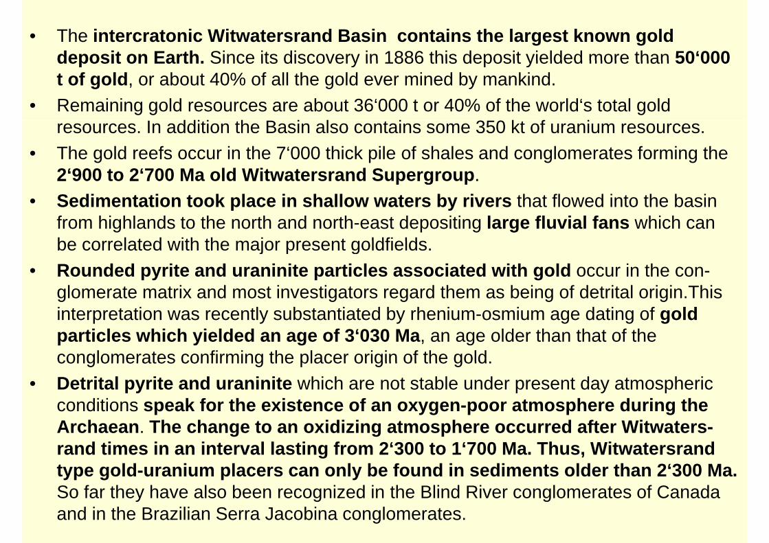
• The intercratonic Witwatersrand Basin contains the largest known gold deposit on Earth Since its discovery in 1886 this deposit yielded more than 50‘000deposit on Earth. Since its discovery in 1886 this deposit yielded more than 50 000 t of gold, or about 40% of all the gold ever mined by mankind.
• Remaining gold resources are about 36‘000 t or 40% of the world‘s total gold I dditi th B i l t i 350 kt f iresources. In addition the Basin also contains some 350 kt of uranium resources.
• The gold reefs occur in the 7‘000 thick pile of shales and conglomerates forming the 2‘900 to 2‘700 Ma old Witwatersrand Supergroup. 2 900 to 2 700 Ma old Witwatersrand Supergroup.
• Sedimentation took place in shallow waters by rivers that flowed into the basin from highlands to the north and north-east depositing large fluvial fans which can be correlated with the major present goldfieldsbe correlated with the major present goldfields.
• Rounded pyrite and uraninite particles associated with gold occur in the con-glomerate matrix and most investigators regard them as being of detrital origin.This g g g g ginterpretation was recently substantiated by rhenium-osmium age dating of gold particles which yielded an age of 3‘030 Ma, an age older than that of the conglomerates confirming the placer origin of the gold.conglomerates confirming the placer origin of the gold.
• Detrital pyrite and uraninite which are not stable under present day atmospheric conditions speak for the existence of an oxygen-poor atmosphere during the A h Th h t idi i t h d ft Wit tArchaean. The change to an oxidizing atmosphere occurred after Witwaters-rand times in an interval lasting from 2‘300 to 1‘700 Ma. Thus, Witwatersrand type gold-uranium placers can only be found in sediments older than 2‘300 Ma. So far they have also been recognized in the Blind River conglomerates of Canada and in the Brazilian Serra Jacobina conglomerates.

6 cm
Matrix-supported conglomerate with large vein-quartz pebbles. Note: pyrite together with gold and
other heavy minerals occur in matrix
Ventersdorp Contact Reef overlain by metabasalts: Mponeng Mine
Outcrop of Witwatersrand conglomerates at Rietkuil, West Rand
Open stope at Saaiplaas
Manganese ore in paleocarst, Kalahari Manganese Field
S O
Thabazimbi
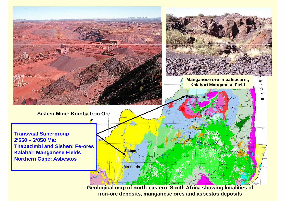
Transvaal Supergroup
Sishen Mine; Kumba Iron Ore
Transvaal Supergroup 2‘650 – 2‘050 Ma:Thabazimbi and Sishen: Fe-oresKalahari Manganese Fields Sishen
Northern Cape: AsbestosMn-fields
Geological map of north-eastern South Africa showing localities of iron-ore deposits, manganese ores and asbestos deposits

• The Transvaal Supergroup with an age of 2’650 to 2’220 Ma consists of a thick pile of chemical and clastic sediments and minor pvolcanics. In it lower part quartzites, cherts and carbonate rocks with interbedded banded iron-formation (BIF) predominate. They are
l i b h l d t i d l it d ifoverlain by shales, sandstones, minor dolomites and manganiferous ironstones in the west.
• The carbonate sediments are of special interest as they contain wellThe carbonate sediments are of special interest as they contain well preserved stromatolite structures formed from blue-green algae. Through oxygen producing photosynthetic processes these primitive life-forms were instrumental in the conversion of the early reducing atmosphere to an oxidizing one.
• The chemical sediments are economically of special interest as they• The chemical sediments are economically of special interest as they carry extensive BIF-horizons which at Sishen and Thabazimbi form world-class iron deposits. In the Northern Cape along the p p gwestern margins of the craton the dolomites contain more than 80% of the world’s known land-based resource of manganese metal.
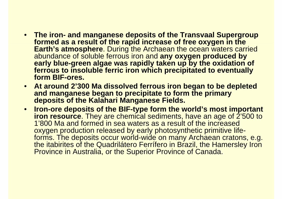
• The iron- and manganese deposits of the Transvaal Supergroup formed as a result of the rapid increase of free oxygen in theformed as a result of the rapid increase of free oxygen in the Earth’s atmosphere. During the Archaean the ocean waters carried abundance of soluble ferrous iron and any oxygen produced by early blue-green algae was rapidly taken up by the oxidation of y g g p y p yferrous to insoluble ferric iron which precipitated to eventually form BIF-ores.
• At around 2’300 Ma dissolved ferrous iron began to be depletedAt around 2 300 Ma dissolved ferrous iron began to be depleted and manganese began to precipitate to form the primary deposits of the Kalahari Manganese Fields.
• Iron-ore deposits of the BIF-type form the world’s most importantIron ore deposits of the BIF type form the world s most important iron resource. They are chemical sediments, have an age of 2’500 to 1’800 Ma and formed in sea waters as a result of the increased oxygen production released by early photosynthetic primitive life-oxygen production released by early photosynthetic primitive lifeforms. The deposits occur world-wide on many Archaean cratons, e.g. the itabirites of the Quadrilátero Ferrífero in Brazil, the Hamersley Iron Province in Australia, or the Superior Province of Canada. , p

Thabazimbi Mine, Kumba Iron Ore Manganese Fields, Mamatwan Mine
Stromatolitic Malmani dolomites, Transvaal Supergroup, Sudwala
Pass
Great Escarpment formed by Transvaal Supergroup near Pilgrims Rest
Impala Platinum
B h ld C lBushveld Complex :PGE, Cr, V, Fluorite
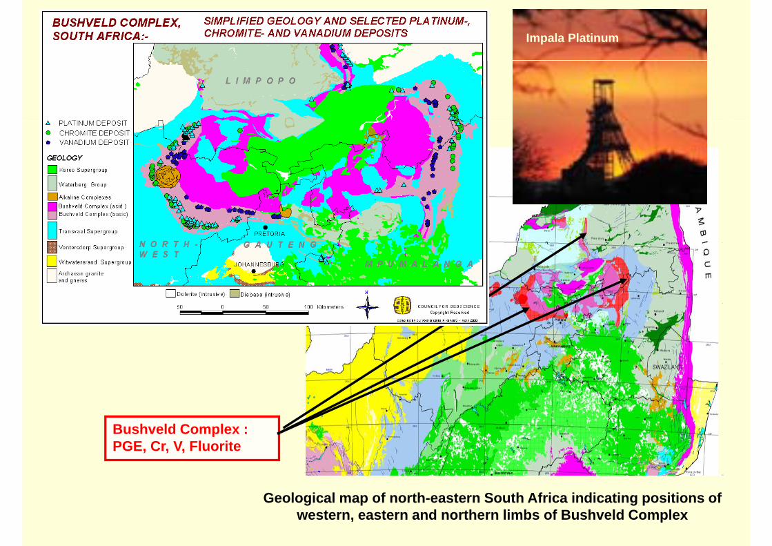
Geological map of north-eastern South Africa indicating positions of western, eastern and northern limbs of Bushveld Complex

Bushveld lithostratigraphy and positions of mineral deposits
Lebowa Granite Suite granites
cassiterite SnRashoop Granophyre Suite
granophyres, porphyritic granites
tit l
Main Magnetite Layer at Steelport
Rustenburg La ered Main Zone (norites,
Upper Zone (diorite, gabbronorite magnetite layers)
magnetite layers cont. vanadium V2O5 UG2
LayeredSuite
Critical Zone (norites, pyroxenites, anorthosites, chromitites)
(gabbronorites,
MRUG2 PGE
chromitite seams CrMerensky Reef
chromitites)
Lower Zone(pyroxenites, dunites, harzburgites, bronzitite)
chromitite seams Cr
Rooiberg
Marginal Zone(norites, pyroxenites)
rhyolites, dacites, fl it Fg
Group basaltic andesites fluorite F
chromitite layers at Jagdlust

• The 2’060 Ma old Bushveld Complex of about 66’000 km2 extent is a saucer-shaped layered igneous intrusion and one of the great geological wonders of the world.
• The Complex is made up of ultramafic to felsic igneous rocks and formed by repeated injection of magma into an enormous chamber. Cooling and fractional mineral crystallisation was a slow process leading to the mineral accumulation into differentcrystallisation was a slow process leading to the mineral accumulation into different sub-horizontal layers or group of layers. They can be traced for distances of more than 200 kilometres.
• The layered sequences dip generally to the centre of the complex and are grouped• The layered sequences dip generally to the centre of the complex and are grouped into the Rustenburg Layered Suite which is divided into the following principal zones: the Marginal, Lower, Critical, Main and Upper Zones.
• Of utmost economic importance is the Critical Zone. At the base it contains pchromitite layers carrying between 50 and 85% chromite. Best Cr/Fe values are found in the lowest layers. which currently produce about 40% of the world’s chromium. Higher up in the Zone two horizons, the UG2 and the Merensky Reef h t th l t l ti f PGM k E th d i l t 60% f thhost the largest accumulation of PGMs known on Earth producing close to 60% of the world’s PGM supply.
• The Merensky Reef is a feldspathic pyroxenite with a thin basal chromitite stringer which is associated with the highest PGM contents The UG2 comprises a mainwhich is associated with the highest PGM contents. The UG2 comprises a main chromite layer, carrying most of the mineralization, followed by a poorly mineralised pegmatoidal pyroxenite footwall.
• The Upper Zone hosts the magnetite layers of which all contain vanadium,The Upper Zone hosts the magnetite layers of which all contain vanadium, decreasing from 2% at the base to 0.3% V2O5 at the top of the zone. The Main Magnetite Layer occurs 130 m above the base of the Upper Zone. It is 2 m thick and is mined in the eastern and western limb. It yields close to 50% of the world’s
di lvanadium supply.
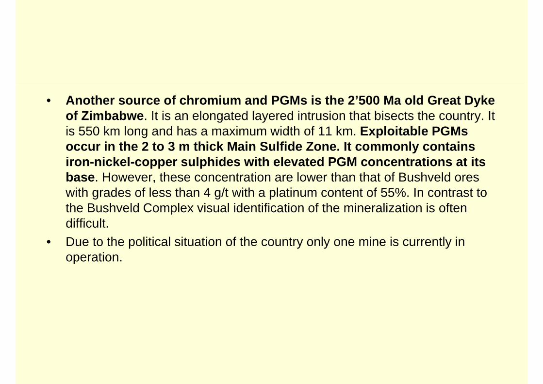
• Another source of chromium and PGMs is the 2’500 Ma old Great Dyke of Zimbabwe. It is an elongated layered intrusion that bisects the country. It i 550 k l d h i idth f 11 k E l it bl PGMis 550 km long and has a maximum width of 11 km. Exploitable PGMs occur in the 2 to 3 m thick Main Sulfide Zone. It commonly contains iron-nickel-copper sulphides with elevated PGM concentrations at its base. However, these concentration are lower than that of Bushveld ores with grades of less than 4 g/t with a platinum content of 55%. In contrast to the Bushveld Complex visual identification of the mineralization is often pdifficult.
• Due to the political situation of the country only one mine is currently in operationoperation.

Dwars River, eastern Bushveld: UG1 chromitite layers within light coloured anorthosite
Potgietersrus, northern limb: Platreef, Sandsloot pit, Amplats
False colour Landsat image of Great Dyke Great Dyke of Zimbabwe
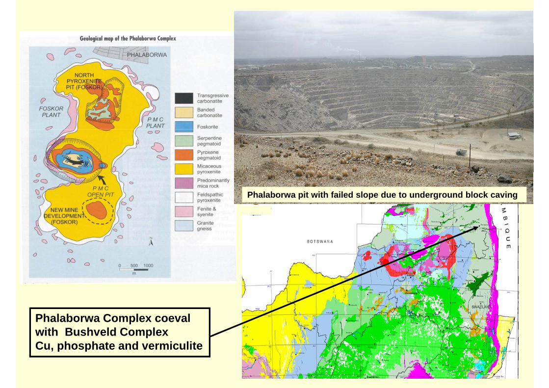
Phalaborwa pit with failed slope due to underground block caving
Phalaborwa Complex coevalwith Bushveld ComplexCu phosphate and vermiculiteCu, phosphate and vermiculite

Th i l Ph l b C l it t d i th th t f th t• The economical Phalaborwa Complex situated in the north-east of the country formed contemporaneous to the Bushveld Complex. It is the site of the largest copper mine in South Africa and contains a world-class phosphate (apatite) and vermiculite deposit.
• The complex is a igneous intrusion composed of three volcanic feeder pipes that occupy an area of 8 km by 4 km. The complex can be interpreted as the deeply eroded zone of an ultramafic carbonatite-type volcano
• The core of the northern pipe has been altered to serpentinite and vermiculite and• The core of the northern pipe has been altered to serpentinite and vermiculite and the core of the southern pipe comprises a phlogopite/vermiculite pegamtoid rich in pyroxene and apatite.
• The central copper bearing pipe consists of carbonatite, an unusual rock d f i l li t d d l it F k it th l i t icomposed of mainly limestone and dolomite. Foskorite another unusual intrusion
surrounds the carbonatite core. It is composed of apatite and Ti-bearing magnetite.• The copper minerals bornite, chalcopyrite and valeriite of the central pipe are mined
by the Palabora Mining Co. (PMC), a member of the Rio Tinto Group. Open-pitby the Palabora Mining Co. (PMC), a member of the Rio Tinto Group. Open pitmining started in 1956 and by reached 2002 a final depth of 750 m when underground mining by the block-caving method started The underground mine has production rate of 30’000 t /day with an average grade of about 0.8 % Cu. Total copper production so far amounts to 2 7 million tons of copper and the projected lifecopper production so far amounts to 2.7 million tons of copper and the projected life of the mine is another 20 years.
• In addition to copper PMC also mines vermiculite and is the world’s largest producer of high-grade vermiculite.Th Ph l b C l i S th Af i ’ t i t t f h h t I i• The Phalaborwa Complex is South Africa’s most important source of phosphate. Is is mainly derived from apatite present in the foskorite which is mined by Foskor Ltd. having the exclusive rights to phosphates in the entire complex.

Besides hosting some of the world’s greatest geological wonders the Kaapvaal Craton is also extraordinary in its mineral wealth (see below table). This indicates that during Archaean times
metallogenic elements such as gold, PGE, nickel, copper and uranium were more efficiently transferred from the mantle to the continental lithosphere and that this transfer decreased in its
density and diversity with time:South Africa role in world mineral production and resources, 2005
(Chamber of Mines of SA)
Commodity Production % Rank Resource base % RankPGMs 303 t 56 7 1 70’000 t 87 7 1PGMs 303 t 56.7 1 70 000 t 87.7 1
Gold 295 t 11.7 1 36’000 t 40.1 1
Chrome ore 7’494 kt 38.7 1 5’500 Mt 72.4 1
Manganese 4’612 kt 13.3 2 4’000 Mt 80.0 1
Vanadium 23’000 t 48.0 1 12’000 kt 31.0 1
Vermiculite 210’000 t 39.6 1 80 Mt 40.0 2
Fluorspar 80 Mt 16.7 2
Antimony 5’979 t 3.2 7 200’000 t 6.4 4
Phosphate rock 2’577’000 t 1.7 10 2’500 Mt 5.0 4
Uranium 795 t 1 6 11 34’000 t 7 2 5Uranium 795 t 1.6 11 34 000 t 7.2 5
Iron ore 40’000 kt 3.0 7 1’500 Mt 0.9 9