The Black Gold Byway - the Wyoming State Historic Preservation
45
Interpretive Plan 1 The Black Gold Byway Interpretive Plan Postcard of the Salt Creek Oilfield, 1920s, from Wyoming Tails and Trails T O X E Y / M C M I L L A N D E S I G N A S S O C I A T E S 218 Washington Street, San Antonio, TX 78204 • O: 210-225-7066 • C: 817-368-2750 http://www.tmdaexhibits.com • [email protected]
Transcript of The Black Gold Byway - the Wyoming State Historic Preservation

Interpretive Plan 1
The Black Gold Byway
Interpretive Plan
Postcard of the Salt Creek Oilfield, 1920s, from Wyoming Tails and Trails
T O X E Y / M C M I L L A N D E S I G N A S S O C I A T E S 218 Washington Street, San Antonio, TX 78204 • O: 210-225-7066 • C: 817-368-2750 http://www.tmdaexhibits.com • [email protected]
Interpretive Plan 2
Table of Contents
Introduction to the Project p. 3
Interpretive Significance of the Topic p. 5
Project Goal p. 6
Project Title p. 6
Intent of Interpretive Plan p. 7
Methodology and Development Process p. 7
Audience Profile and Visitor Needs p. 8
Project Objectives p. 9
Underlying Theme p. 10
Interpretation Topics and Subtopics p. 11
Storyline Development p. 13
Media Plan and Recommendations p. 33
References and Acknowledgements p. 44
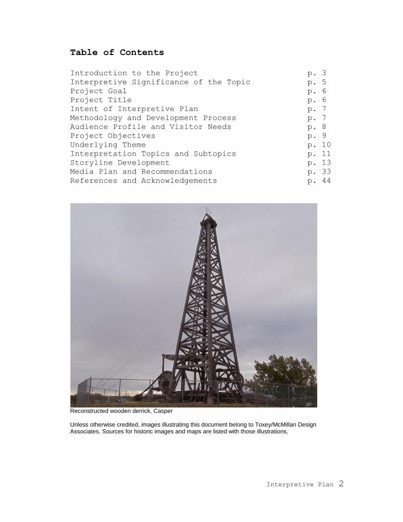
Reconstructed wooden derrick, Casper Unless otherwise credited, images illustrating this document belong to Toxey/McMillan Design Associates. Sources for historic images and maps are listed with those illustrations.

Interpretive Plan 3
Introduction to the Project The Wyoming Historic Mine Trail and Byway Program is a division of the State Historic Preservation Office (SHPO)‘s Wyoming Monuments
and Markers Program. It was established by the Wyoming legislature in 2005 to identify and designate historic mine locations and trails
within the state. After completion in 2009 of the program‘s first trail, Gold Flakes to Yellowcake Historic Mine Trail, nominations were solicited for the subject of a second trail. The selected nomination
identified the Old Salt Creek Highway as a worthy route. This feature is a small part of the larger history of the Salt Creek Oilfield. Through
a series of meetings among members of the State Historic Preservation Office, interested parties in the Salt Creek region, and the selected exhibit developer (Toxey/McMillan Design Associates—TMDA), the
decision was made to extend the new mine trail topic to include the broad history of the Salt Creek Oilfield. The following pages develop an interpretive plan for this rich and multi-faceted topic.
The new byway will reinforce the Historic Mine Trail and Byway
Program objectives: 1) to provide a precise history of mineral development in Wyoming; 2) to interpret the role of mining and minerals in the development of Wyoming‘s economy; 3) to identify and
describe Wyoming‘s mining and mineral development heritage. By creating public awareness of this significant site and by placing its
history in value through interpretation, the exhibit developers further hope to encourage conservation of the site and related artifacts.
Panorama of the town of Salt Creek (current day Midwest), courtesy of the Western History Center, Casper College

Interpretive Plan 4
The Salt Creek Oilfield region spans from Casper north to Midwest and east to Edgerton and includes the three associated oilfields: Salt
Creek, Teapot Dome, and Shannon. Other vital elements of the field‘s history are multiple pipelines (as well as the defunct North & South
Railroad and the Salt Creek Highway) that connect the oil and gas fields to Casper and the former refineries in Casper that received and transformed gas and oil.
1890s map of Casper and Salt Creek Oilfield, courtesy of the Western History Center, Casper College

Interpretive Plan 5
Interpretive Significance The intertwined stories of the development of three contiguous oilfields—Shannon (the first), Salt Creek (the largest), and Teapot
Dome (the most famous)—are also the story of the growth and development of the city of Casper and the firm establishment of
Wyoming‘s energy industry. Nationally these fields have further relevance: Salt Creek Oilfield launched Wyoming onto the national scene of energy producers, while Teapot Dome rocked the nation with
a scandal near the magnitude of Watergate. The three fields also present textbook examples of anticline oil traps.
Not only were these oil fields—namely Salt Creek—unimaginably rich, but also most of their produce has been of such a high quality that
less refining is necessary for industrial application than other crude. In fact, the railroad used this oil unrefined as a lubricant in the 1890s.
The fields have also been the testing ground for many new drilling and extraction technologies. Salt Creek was one of the first electrified
oilfields, and Teapot Dome is a government research center studying drilling techniques.
Of greatest significance to the local community, however, is the social history of the oilfield, still much alive in the memories of residents—many of whose families moved to this area in response to the oil boom.
Although only about 600 people today live in the two oilfield towns of Midwest and Edgerton, the area was not so remote in the 1920s–30s.
It supported 10,000 or more residents in eight towns and hundreds of camps. Serviced by a railroad and highway, the towns had nice shops, banks, stage theaters, movie theaters, dancehalls with oak floors, a
hot well-fed swimming pool, tennis courts, ball fields, excellent eateries, hotels, community halls, local newspapers, an American
Legion Clubhouse, libraries, schools, car dealerships, mechanic garages—and, of course, saloons, gambling houses, and brothels. The wind-swept sage prairies seen today belie the lively society that
flourished here 90 years ago.
View of Salt Creek Oilfield

Interpretive Plan 6
Project Goal: The project goal is to develop an historic mine byway that interprets the history and defines the heritage of the Salt Creek Oilfield through
a variety of media. These media are intended to engender public understanding, appreciation, and stewardship of the history and
legacy of the Salt Creek Oilfield.
Project Title: Many names were considered for the title of this byway. The voted
favorite is Black Gold Byway. A few alternatives considered include:
Salt Creek Trail (the former name of the Salt Creek Highway) Gusher Trail Boom Town Byway
Boom Town Trail Oil Patch Byway
Salt Creek Oilfield, courtesy of the Salt Creek Museum, Ed Bille Collection

Interpretive Plan 7
Intent of the Interpretive Plan The goal of this interpretive plan is to guide the development of signs, exhibits, and other media. To accomplish this, the plan:
• Synthesizes available visitor information to understand the project‘s audience
• Defines learning, behavioral, and emotional objectives for the media and exhibit components
• Establishes an interpretive theme for the project
• Develops storylines • Identifies landscape features for interpretation • Defines a driving route that ties together these features in a
cohesive experience • Outlines other media for further development and interpretation of
the byway.
Methodology and Development Process The interpretation developed here results from a combination of
meetings, conversations, field research, and bibliographic and archival research. In particular, these include: a project kick-off meeting with
members of SHPO in Cheyenne on June 22, 2010, an interested parties meeting in Midwest on October 8, 2010 (which was attended by 17 people, 13 of whom were area residents), a research trip made by the
exhibit developers to the region, and other bibliographic and archival research. During the research trip (October 6–8, 2010), TMDA met with
professors at Casper College whose students are conducting research on Salt Creek, namely Jeff Sun and Ebba Stedillie (telephone interview). We were also introduced to the rich resources of the Western History
Center by archivist Teri Hedgpeth. In addition, we spent a full day touring the Salt Creek Oilfield with geologist John Albanese, and we were fortunate to meet with two active members of the Natrona County
Historical Society, Jackie and Pinky Ellis. A list of bibliographic sources consulted can be found at the end of this document.
Pinky Ellis, Anne Toxey, and Jackie Ellis, Casper, October 7, 2010
Interpretive Plan 8
Audience Profile Although interpretive elements for the byway project may include museum exhibits, websites, and other forms not related to driving
along the trail, the main venue for interpretation will be large panels and related media (brochures, podcasts, radio) experienced along the
trail. The traveling public along Interstate-25 (Highway 87) is therefore the main anticipated audience. This includes both Wyomingites and non-state residents.
SHPO plans to market the drive through the Wyoming Office of Tourism (WOT). This agency‘s 2009 statewide Visitor Profile Reports
show small families or groups of adults as being the greatest sector of visitors to the state: adults aged ca. 47 years (66.1% married, 94.5%
having some college or tech school training or more extensive education) traveling with 0–2 children. The average traveling party size of 3.1 was often composed of all adults. Approximately 77% of the
visitors in this survey used the Internet to plan or source information for their trips to Wyoming. We can therefore assume that most visitors
to this site will be educated and computer-literate. Giving the trail a presence online would reach a large potential audience. Development of high-tech exhibits would also be appropriate for this profile.
The 2009 Visitor Profile Report further reveals that the most significant trip motivators were (in the order of importance): visiting
state and national parks, scenic drives, hiking or backpacking, camping, wildlife watching, visiting historical sites, visiting hot
springs, visiting museums, sightseeing tours, fishing, snow skiing or snowboarding, shopping, river rafting, and attending a festival or fair. The Black Gold Byway will provide opportunities for many of these
activities: scenic drives, hiking or backpacking, wildlife watching, visiting historical sites, and visiting museums.
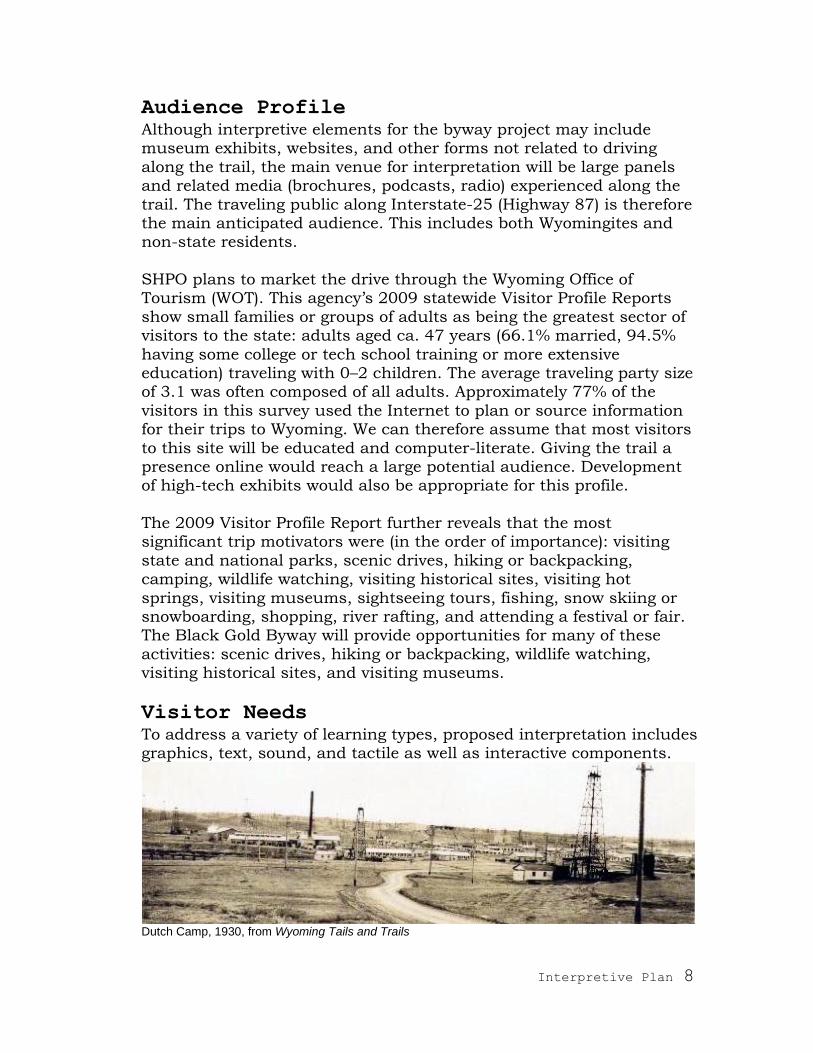
Visitor Needs To address a variety of learning types, proposed interpretation includes graphics, text, sound, and tactile as well as interactive components.
Dutch Camp, 1930, from Wyoming Tails and Trails
Interpretive Plan 9
Project Objectives The objectives listed below were voiced and discussed at the Interested Parties meeting in Midwest on October 8, 2010.
Learning Objectives:
After experiencing the Black Gold Byway, visitors will: • understand what an anticline is
• know what the Salt Creek Oilfield has produced in a century of drilling and know that not only was it one of the richest oilfields in the US but also that it was the largest light oil producing field
in the world • understand the cultural and economic influence that Salt Creek
Oilfield had on the region and state • understand how communities grew around oil production • understand how important transportation routes are for
communities and industries to develop • know the story of the Teapot Dome Scandal
• understand the important roles that Midwest, Edgerton, and Casper played in the development of Salt Creek Oilfield and the delivery of its product across the US and the globe
• understand that Casper grew and flourished as a result of Salt Creek Oilfield
• understand basic concepts behind secondary recovery techniques
• recognize the boom and bust nature of natural resource exploitation
• understand that many of Wyoming‘s landscapes have a history to tell even though physical features of the past no longer exist.
Behavioral Objectives:
After experiencing the Black Gold Byway, visitors will:
• visit some of the off-trail historic sites, such as the Salt Creek Museum in Midwest and the Midwest Cemetery west of town
• explore and spend time in the towns of Midwest and Edgerton
• want to learn and discover more about the state‘s geology and history
• see Casper and the barren landscape of Salt Creek Oilfield with different eyes
• visually analyze the geology of the area as they drive away (e.g.,
look for anticlines) • recognize the importance of conservation of natural resources
• become involved in historic preservation projects.

Interpretive Plan 10
Emotional Objectives:
After experiencing the Black Gold Byway, visitors will:
• be amazed by the significance that this site (now largely empty and unpeopled) has had to the economy of the state
• be impressed with the ―firsts‖ associated with Midwest and Salt
Creek Oilfield: first lighted football field, first electrified oilfield, etc.
• feel a connection with the history and the people who have come
before them • feel appreciation for the respect and quality of life provided by
Midwest Refining Company to its workers in Midwest and surrounding camps
• feel respect for the land as a resource
• appreciate Wyoming‘s diversity of landscapes, industries, and peoples
• appreciate the boom and bust nature of natural resource exploitation.
Panorama of Salt Creek Oilfield today
Underlying Theme: An interpretive project has a central theme, which ties together the information presented. It defines what the content covers and does not
cover. It establishes the main idea, like the moral of a story.
Black Gold Byway Theme: Although windblown sage, a few pump jacks, and jack rabbits are all
that meets the eye today, this sparsely populated land made an impact of historic proportions on the economy and society of
Wyoming.

Interpretive Plan 11
Interpretation Topics and Subtopics:
Topic 1: Oilfield History
History of the development of the Salt Creek Oilfield 1a: The light, paraffin-based oil produced here and located at
shallow levels attracted development.
1b. A complex claims battle ensued (bringing great wealth to lawyers, while the oil brought wealth to prospectors), eventually
leading from placer claims to mineral leases and from competition among companies to unitization of the field.
1c. Contemporaneous development of refineries in Casper
1d. Developments in transportation of oil from the field to the refineries and end users and of equipment to the field (string teams, pipelines, the Salt Creek Highway, the North & South
Railroad, and connections to major rail lines)
Topic 2: Social and Economic History
Social, demographic, and economic impact of the Salt Creek Oilfield
on the region and state; the overall growth (and eventual decrease) in population here compared to the rest of the state
2a. Development of Casper from a sleepy sheep town to Oil Capital
of the Rockies 2b. The boom towns, rag towns, company town, and oil camps that
proliferated in the oilfields; the society that developed here; the ghost towns that remain and the two survivors: Midwest and Edgerton
2c. Oral histories collected by Professor Ebba Stedillie‘s students at Casper College
2d. GIS town and camp reconstructions developed by Professor Jeff Sun‘s students at Casper College
Topic 3: Political History
Teapot Dome Scandal
There are, of course, many other political ramifications of the Salt Creek story; however, they pale in comparison to the Teapot Dome
Scandal and are not included in the scope of this interpretive plan.
Topic 4: Technical History
Changes in methods of drilling and extracting oil and gas, from free-flowing oil wells (naturally pressurized by gas), to pumped wells (this
being one of the first electrified fields), to secondary and tertiary recovery measures

Interpretive Plan 12
3a. Current underground piping system and where the oil goes 3b. What products are made with Salt Creek oil
Topic 5: Geologic History
How geologists knew that there was oil here by studying the landscape 3a. Local geology and diagram of the Salt Creek anticline 3b. Why oil is located here
3c. How oil is formed
Midwest Cemetery

Interpretive Plan 13
Storyline Development There is a small allowance in the descriptions below for the overlap of material. This is not only because the subjects overlap and reinforce
each other, but also because, in the case of roadside signs, we do not expect all visitors to read all signs.
Topic 1: Oilfield History
Placer oil claims were filed in the Salt Creek area beginning in 1883,1
five years before Casper was founded and seven years before Wyoming territory was proclaimed a state. This treeless, wind-swept region
attracted very little interest in other uses—vegetation being sparse for grazing, wood nonexistent for milling, water scarce for farming, and gold and other hot commodities nonexistent here. With the nation not
yet dependent on oil at this point, few people took interest in this extremely remote region‘s potential for oil, far from railroads and far
from users. Treatment of the claims was therefore loose at best: many claims overlapped, many were abandoned, and many were ―jumped‖ (when a new claim is made over an abandoned one). This confusion of
ownership—followed by significant oil strikes and much money to gain from ownership—led to decades of costly lawsuits. Dummy claims and illegal jumping (of non-abandoned claims) further complicated
matters.
String team removing claim jumper’s shack, courtesy of Western History Center, Casper College
Natural oil seeps and basic knowledge of geology alerted the observant to the region‘s potential wealth; however, the earlier prospectors did
not have the capital necessary to dig wells and develop an infrastructure for transporting black gold to market. In order to hold
onto (or ―validate‖) their claims (which they later hoped to sell for a big profit), prospectors gave semblance of seeking oil by digging shallow
1 Stephen Downey made the first known claim. It included Jackass Spring, ca. 1.5
miles north of current-day Midwest.

Interpretive Plan 14
pits. Historian Ed Bille describes early reports of the Salt Creek field as being covered with hundreds of holes and pits due to the claims
process. The best known and most successful of these hole diggers was Cy Iba, a name that continues to resonate throughout the region (and haunt courtrooms).2
The first serious drilling in the region was begun in 1889 by P.M.
Shannon, representing the Pennsylvania Oil & Gas Company—and therefore the first funded, corporate interest in the region. The site of this well, appropriately named Shannon No. 1, is technically in an
oilfield (the Shannon Pool) immediately north of the Salt Creek Oilfield, but part of the same geologic formation. Shannon‘s name also
marks the rocky escarpment defining the Salt Creek oilfield (Shannon sandstone).
The company continued drilling wells in the following years and built a small refinery in Casper in 1895 (or 1894, depending upon the
source) to process its oil. To transport the oil 50 miles to Casper, the company filled wooden barrels in a train of wagons hauled by ―string teams‖ of 12–18 horses—a trip that took between 2–5 days one way
(though one report said that it could take two weeks in bad weather).
Freight team hauling oil from Salt Creek to Casper, 1900, courtesy of the Western History Center, Casper College, Mokler Collection
A Belgian-backed company bought out the Pennsylvania Oil & Gas Company‘s Wyoming holdings in 1903. This transaction ushered in a
long period of European (namely Belgian, French, and Dutch) capital funding the establishment of the oil industry here. New York,
California, and Colorado investors also contributed to the development of the Salt Creek field (and to fierce fights over ownership and control). The Dutch were the first to drill in Salt Creek Oilfield, proper, bringing
2 Cy Iba entered the Salt Creek prospecting scene in 1887. Following his death in
1907, his family continued his work of validating claims by digging holes and suing
competitors. Their tenacity and temerity paid off with great riches.

Interpretive Plan 15
in a gusher in 1908 with their first well. This event ushered in thousands of prospectors and job-seekers, resulting in Wyoming‘s first
oil boom.
The oil found here is unusually light in color and density. In the first analysis of Shannon oil by petroleum engineers in Pittsburgh, it was deemed unnatural to be so light. In its crude form, Shannon oil was
sold to the Union Pacific, Denver, and Gulf Railway Company for use as a lubricant. The Salt Creek oil turned out to be even lighter. Found at relatively shallow levels (ca. 1,000 feet underground), the product
appealed greatly to oil companies and attracted many newcomers to central Wyoming.
The most diplomatic and successful of the early corporate endeavors at Salt Creek were those of Midwest Oil Company (funded by Colorado
and French investors), which organized and entered the game in 1911 (or 1910, depending upon the source). Midwest did the most of any
company to develop Salt Creek—both the oil and gas industries there and the comforts of living there. It built storage tanks in the field to prevent the loss of oil, expanded refineries in Casper, built pipelines
(beginning in 1911) from the field to the refineries, and built employee camps as well as expanded Home Camp into a respectable company town (variously called Home Camp, Salt Creek, and Midwest).
Constructing a pipeline from Salt Creek to Casper, courtesy of Salt Creek Museum, Ed Bille Collection
Interpretive Plan 16
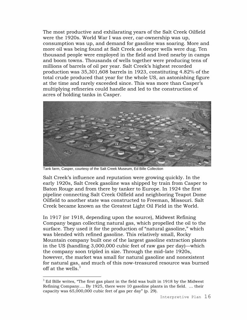
The most productive and exhilarating years of the Salt Creek Oilfield were the 1920s. World War I was over, car-ownership was up,
consumption was up, and demand for gasoline was soaring. More and more oil was being found at Salt Creek as deeper wells were dug. Ten
thousand people were employed in the field and lived nearby in camps and boom towns. Thousands of wells together were producing tens of millions of barrels of oil per year. Salt Creek‘s highest recorded
production was 35,301,608 barrels in 1923, constituting 4.82% of the total crude produced that year for the whole US, an astonishing figure at the time and rarely exceeded since. This was more than Casper‘s
multiplying refineries could handle and led to the construction of acres of holding tanks in Casper.
Tank farm, Casper, courtesy of the Salt Creek Museum, Ed Bille Collection
Salt Creek‘s influence and reputation were growing quickly. In the early 1920s, Salt Creek gasoline was shipped by train from Casper to Baton Rouge and from there by tanker to Europe. In 1924 the first
pipeline connecting Salt Creek Oilfield and neighboring Teapot Dome Oilfield to another state was constructed to Freeman, Missouri. Salt Creek became known as the Greatest Light Oil Field in the World.
In 1917 (or 1918, depending upon the source), Midwest Refining
Company began collecting natural gas, which propelled the oil to the surface. They used it for the production of ―natural gasoline,‖ which was blended with refined gasoline. This relatively small, Rocky
Mountain company built one of the largest gasoline extraction plants in the US (handling 3,000,000 cubic feet of raw gas per day)—which the company soon tripled in size. Through the mid–late 1920s,
however, the market was small for natural gasoline and nonexistent for natural gas, and much of this now-treasured resource was burned off at the wells.3
3 Ed Bille writes, ―The first gas plant in the field was built in 1918 by the Midwest
Refining Company…. By 1925, there were 10 gasoline plants in the field. … their
capacity was 65,000,000 cubic feet of gas per day‖ (p. 29).
Interpretive Plan 17
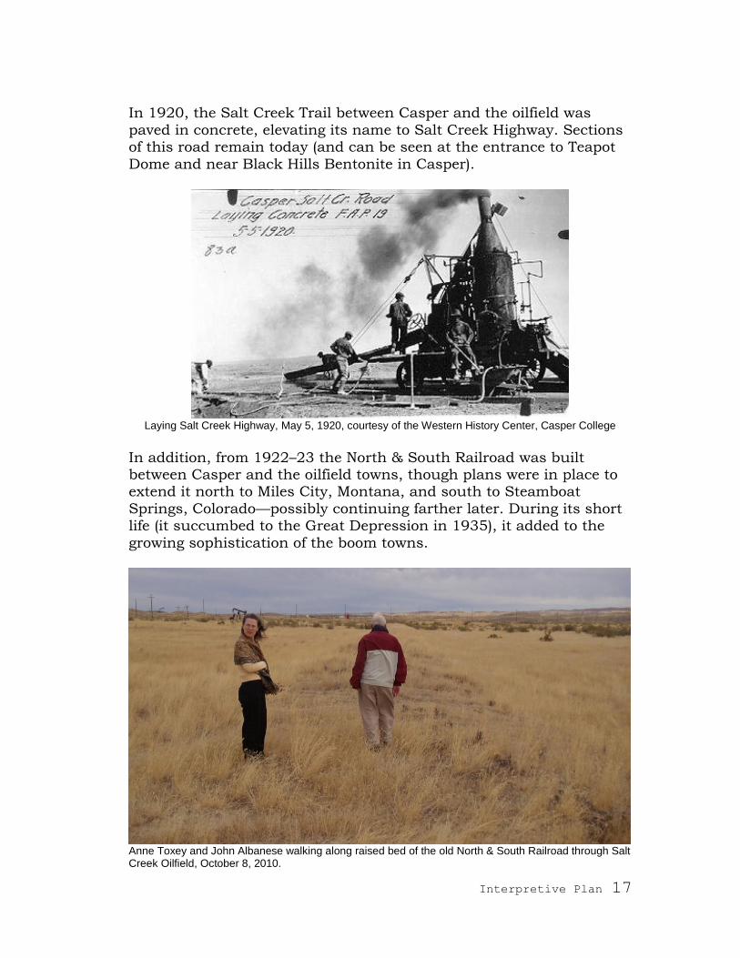
In 1920, the Salt Creek Trail between Casper and the oilfield was
paved in concrete, elevating its name to Salt Creek Highway. Sections of this road remain today (and can be seen at the entrance to Teapot
Dome and near Black Hills Bentonite in Casper).
Laying Salt Creek Highway, May 5, 1920, courtesy of the Western History Center, Casper College
In addition, from 1922–23 the North & South Railroad was built between Casper and the oilfield towns, though plans were in place to extend it north to Miles City, Montana, and south to Steamboat
Springs, Colorado—possibly continuing farther later. During its short life (it succumbed to the Great Depression in 1935), it added to the
growing sophistication of the boom towns.
Anne Toxey and John Albanese walking along raised bed of the old North & South Railroad through Salt Creek Oilfield, October 8, 2010.

Interpretive Plan 18
Midwest bought or merged with other companies, becoming the largest operator in the field by 1914, though only controlling about
one-third of the field‘s operation. With the government‘s 1920 decision to retain ownership of the land and allow leasing of mineral rights (the
Oil and Gas Leasing Act of 1920), many of the placer claim problems subsided. Wary of trusts after the break-up of Standard Oil in 1911, the US government cautiously approved Midwest‘s proposal to
―unitize‖ the Salt Creek Oilfield in 1935. Salt Creek was one of the first unitized oilfields in the US. Under this efficient arrangement, Midwest operated the whole field (all the different companies‘ wells and
properties), and it paid a portion of profits to the other owners. Without competition for the oil, the company could make better
decisions and investments in infrastructure that would serve the entire field. Although the operating company has been sold several times since that date, the unitized arrangement continues to function
today, currently under the leadership of Anadarko Petroleum Corporation.
The wells still produce oil today, though at much reduced rates than in the 1920s—compare the 1921 production of 35,301,608 barrels to
the 2010 production of 4,348,635 barrels. Salt Creek is now being mined for ―tertiary recovery‖ using new techniques to force additional oil from the ground.
The field played a major role in making Wyoming an energy state and
a major contributor to the nation‘s energy supplies. The state maintains this role today with the continued production of oil in 20 out of 23 counties, natural gas, coal, uranium—and now wind-energy
generation. In all these areas, Wyoming has substantial assets.
The community of Gas Plant is a suburb of Midwest.

Interpretive Plan 19
Topic 2: Social and Economic History
Mining in general has been responsible for bringing residents to
Wyoming, possibly more than any other industry. Mining has also provided the state with a counter-economy to balance the vagaries of ranching and agriculture—though one more susceptible to booms and
busts. With the announcement of gushers in Salt Creek in the early 1900s
and money finally flowing to develop the industry there, jobs were available. People arrived from all directions, especially ―boomers‖
(those who follow oil booms) from oilfields in Texas, Oklahoma, California, Missouri, the Dakotas, and Nebraska.
Due to the considerable time it took to travel to Casper at this time, oilfield workers needed to live near the field. Many companies built
―camps‖ next to their wells to house employees; however, not all workers could be accommodated. Some people began building their own camps and towns. Settlements composed of tents were called
―ragtowns.‖ As companies changed hands and shifted drilling operations, these camps changed names and locations. Several homesteaders also converted their ranches into towns profiting from
the real estate opportunity. These included Lavoye, Snyderville, and Edgerton. Edgerton exists today.
Lybyer family in front of tent house, Salt Creek (later Midwest), courtesy of Western History Center,
Casper College
Over the course of the boom years, some 200 camps and boom towns existed, housing over 10,000 people during the peak years of the
1920s. A few camp and town names include: Sunnyside, Home Camp (renamed Midwest), Mountain View, Riverside, Dutch Camp, Canadian Camp, Skinnerville, Posseyville, Chicago, Economy Camp, Lewis
Interpretive Plan 20
Camp, Shannon Camp, North Camp, Iba Camp, Hjorth Camp, Hanley and Bird Camp, Northwestern Camp, Old Midwest Camp, South
Camp, New Lavoye, Salt Creek, Teapot, and Columbine.
Although a ―bust‖ finally came that sent many of these people packing in search of other work, quite a few people who live in the Casper-Salt Creek area today have ties to the Boomers. They speak nostalgically of
the glorious days and exciting times that they or their forebears experienced. These were times of hope and optimism shared by many during the Post-World War I era. In the case of Salt Creek, they were
building new communities, realizing dreams, and achieving wealth.
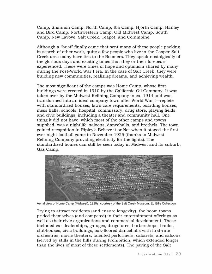
The most significant of the camps was Home Camp, whose first buildings were erected in 1910 by the California Oil Company. It was taken over by the Midwest Refining Company in ca. 1914 and was
transformed into an ideal company town after World War I—replete with standardized houses, lawn care requirements, boarding houses,
mess halls, schools, hospital, commissary, drug store, playing fields, and civic buildings, including a theater and community hall. One thing it did not have, which most of the other camps and towns
supplied, was a nightlife: saloons, dancehalls, and brothels. The town gained recognition in Ripley‘s Believe it or Not when it staged the first ever night football game in November 1925 (thanks to Midwest
Refining Company providing electricity for the lights). The standardized homes can still be seen today in Midwest and its suburb,
Gas Camp.
Aerial view of Home Camp (Midwest), 1920s, courtesy of the Salt Creek Museum, Ed Bille Collection
Trying to attract residents (and ensure longevity), the boom towns prided themselves (and competed) in their entertainment offerings as
well as their civic organizations and commercial development. These included car dealerships, garages, drugstores, barbershops, banks, clubhouses, civic buildings, oak-floored dancehalls with first-rate
orchestras, movie theaters, talented performers, cabarets, and saloons (served by stills in the hills during Prohibition, which extended longer
than the lives of most of these settlements). The paving of the Salt

Interpretive Plan 21
Creek Highway and the establishment of the North & South Railroad greatly enhanced these towns and gave them hope for permanence by
making them more accessible and more attractive to residents.
Stills in the hills, courtesy of the Salt Creek Museum, Ed Bille Collection
One of the most unsettling episodes in Salt Creek society is the saga of Lavoye, one of the larger boom towns and a railroad stop. This thriving
town of 1,000 residents had been developed on homesteader Louie Lavoye‘s land; however, the Ohio Oil Company contested Lavoye‘s claim and wanted the town to move in order to drill there. In a fight
that went all the way to the Secretary of the Interior, the oil company won. Those who did not move by the established date were forcibly removed. A fire that occurred at the same time accelerated evictions.
Some residents moved to surrounding towns, but many started the new town of New Lavoye near Teapot Dome. Its claim to fame was a
large indoor swimming pool (the largest in the state) fed with naturally hot water piped from Tisdale Mountain. Until recently, this pool has been visible from highway 259.
The Salt Creek boom days ended in the late 1920s with diminishing

Interpretive Plan 22
oil production due to reduced gas pressure and decreased supply. This also coincided with the arrival of the Great Depression. Wages
dropped, layoffs took place, and people left for more active oilfields. In addition, fewer camps were needed with the consolidation of
production under one company (unitization of the field). Numerous devastating fires and the folding of the North & South Railroad accelerated the death of all the boom towns with the exception of
Edgerton and the company town of Midwest (formerly Home Camp).
A sidewalk and a few trees are all that remain of this oil camp.
Though much reduced from its boom days‘ magnitude, Midwest remains today because the owning company became the oilfield‘s sole
operator. It was also the largest and most established of the oilfield communities. In 1975–76, however, Midwest converted from a
company town to an independent, incorporated town. Edgerton remains today because it complemented Midwest through provision of services and amenities that the straight-laced company town did not
allow.
Although the oil industry overshadowed other activities in this area during the excitement of the 1920s, the land has since reverted to ranching. Even public land (encompassing most of the oilfield) is
leased for grazing. Abandoned boom town and camp structures that

Interpretive Plan 23
survived fires were bought, moved, and repurposed by ranchers and continue to be used today.
The town that benefited most from Salt Creek‘s black gold was Casper.
Reports vary on what Casper was like before the boom, but all agree that oil built the city. In 1888 just before P.M. Shannon began drilling his first well 50 miles to the north, Casper was platted as the terminus
of the Wyoming Central Railway (a subsidiary of the Chicago & North Western Railway). It was first identified as a sheep town (especially on payday when sheepherders and cowboys filled the saloons), but it
soon became known as ―Oil City‖ and then the ―Oil Capital of the Rockies.‖ Although Shannon was hauling oil to Casper‘s railhead and
then to his refinery in Casper in the early-to-mid 1890s, the boom hit twenty years later. A July 11, 1913 article in Denver‘s The Daily News reported: ―There is still a frontier ... in Casper, Wyo., at once the third
largest sheep and wool shipping center in the world and the scene of oil excitement not equaled since thousands went mad over the
prospect of becoming rich at Beaumont, Texas.‖
Casper, 1913. Notice small area of town and expansive areas of refineries, pipelines, and railroads, courtesy of the Salt Creek Museum, Ed Bille Collection
Between 1912 and 1918, Casper‘s population increased from 2,000 to 20,000. Not only was it home to oil companies and their staff, but the
industry also sparked development of oil-related services. In addition to refineries, tank farms, and pipelines, these companies erected downtown office buildings, and their personnel built houses and a
strong sense of community. The Salt Creek Oilfield was largely responsible for Casper‘s dramatic growth, but there were other
oilfields, too, such as Big Muddy east of Casper, which contributed to

Interpretive Plan 24
the city‘s role as the central Rockies hub for mining and energy exploration.
One of the results of Casper‘s central position in the state‘s oil
industry was that it earned Natrona County the distinction of being the most industrialized county in the state and therefore the county with the highest tax revenues. These have afforded Casper and
Natrona County excellent schools, roads, and other amenities. It is oil, not gold, that has contributed to Wyoming‘s wealth and quality of life.
Topic 3: Political History
Salt Creek and other nearby oilfields emotionally charged the nation
in the 1920s, first with excitement during the early exploitation of oil that drew prospectors and wildcats from all directions, then with a
scandal that rocked the nation. Located immediately east of Salt Creek Oilfield is Teapot Dome, an
oilfield named for a nearby teapot-shaped rock formation (having lost its handle and spout in recent years due to harsh weather). In 1909 President Taft reserved this oilfield, along with two fields in California,
for the US Navy‘s use in case of national emergency. This caused consternation to several private oil companies who had already made
claims and begun extracting oil from the property. A decade later under President Warren G. Harding‘s administration, control of the naval oil reserves was wrested from the Navy Department for the
Department of the Interior by Secretary of the Interior Albert B. Fall—an act which was later deemed to be illegal.
Teapot Rock today
Interpretive Plan 25
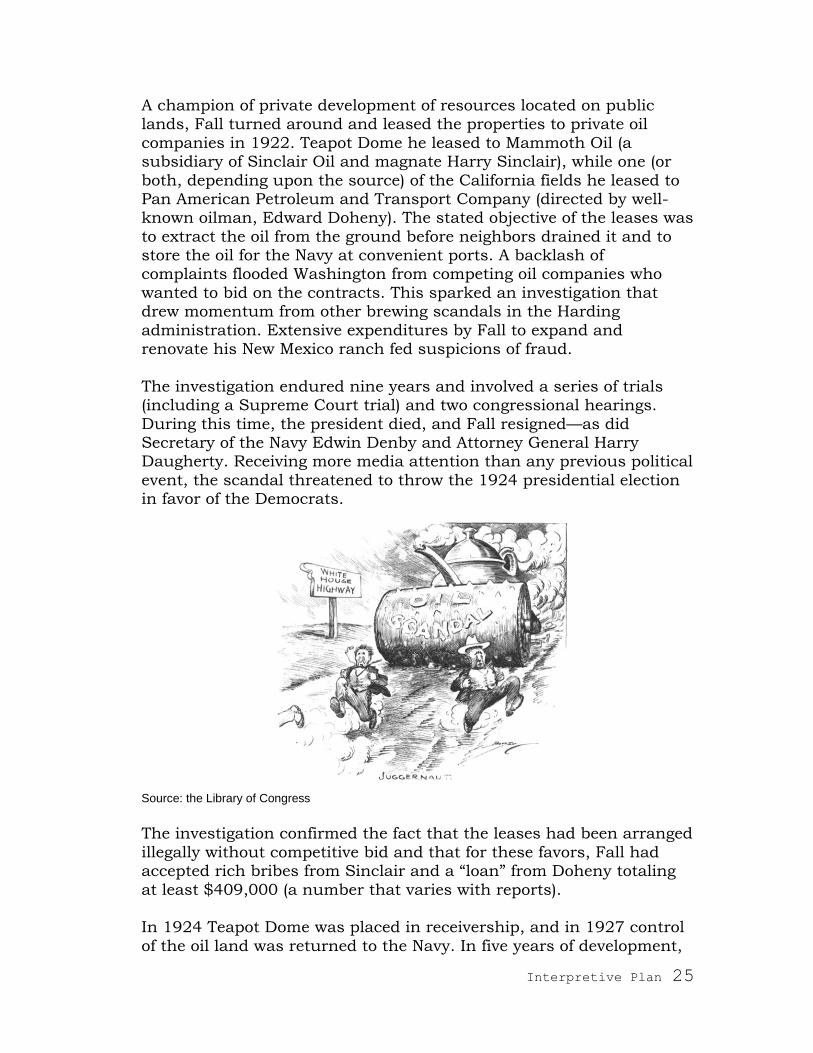
A champion of private development of resources located on public lands, Fall turned around and leased the properties to private oil
companies in 1922. Teapot Dome he leased to Mammoth Oil (a subsidiary of Sinclair Oil and magnate Harry Sinclair), while one (or
both, depending upon the source) of the California fields he leased to Pan American Petroleum and Transport Company (directed by well-known oilman, Edward Doheny). The stated objective of the leases was
to extract the oil from the ground before neighbors drained it and to store the oil for the Navy at convenient ports. A backlash of complaints flooded Washington from competing oil companies who
wanted to bid on the contracts. This sparked an investigation that drew momentum from other brewing scandals in the Harding
administration. Extensive expenditures by Fall to expand and renovate his New Mexico ranch fed suspicions of fraud.
The investigation endured nine years and involved a series of trials (including a Supreme Court trial) and two congressional hearings.
During this time, the president died, and Fall resigned—as did Secretary of the Navy Edwin Denby and Attorney General Harry Daugherty. Receiving more media attention than any previous political
event, the scandal threatened to throw the 1924 presidential election in favor of the Democrats.
Source: the Library of Congress
The investigation confirmed the fact that the leases had been arranged
illegally without competitive bid and that for these favors, Fall had accepted rich bribes from Sinclair and a ―loan‖ from Doheny totaling
at least $409,000 (a number that varies with reports). In 1924 Teapot Dome was placed in receivership, and in 1927 control
of the oil land was returned to the Navy. In five years of development,
Interpretive Plan 26
57 wells were drilled at Teapot Dome—including the biggest gusher in the history of Wyoming—and 3.5 million barrels of oil were extracted,
which was less than anticipated. In fulfillment of their contract, Mammoth also constructed a 700-mile pipeline from Teapot Dome to
the Missouri River and built Navy structures at a New Hampshire port. The Teapot Dome wells were sealed in 1927.
In 1931 Fall was convicted, fined, and imprisoned for committing a felony while in office—the first Cabinet officer to bear this shame. Although Fall was guilty of these crimes, he also became the ―fall‖ guy
for other corruption in the Harding administration. Ironically, Sinclair and Doheny were acquitted of bribery, but Sinclair was fined and
sentenced to jail for contempt of both court and Senate. The result of the Teapot Dome Scandal was to open the public‘s eyes to the close relationship between the government and big business, in particular
the oil industry.
Topic 4: Technical History
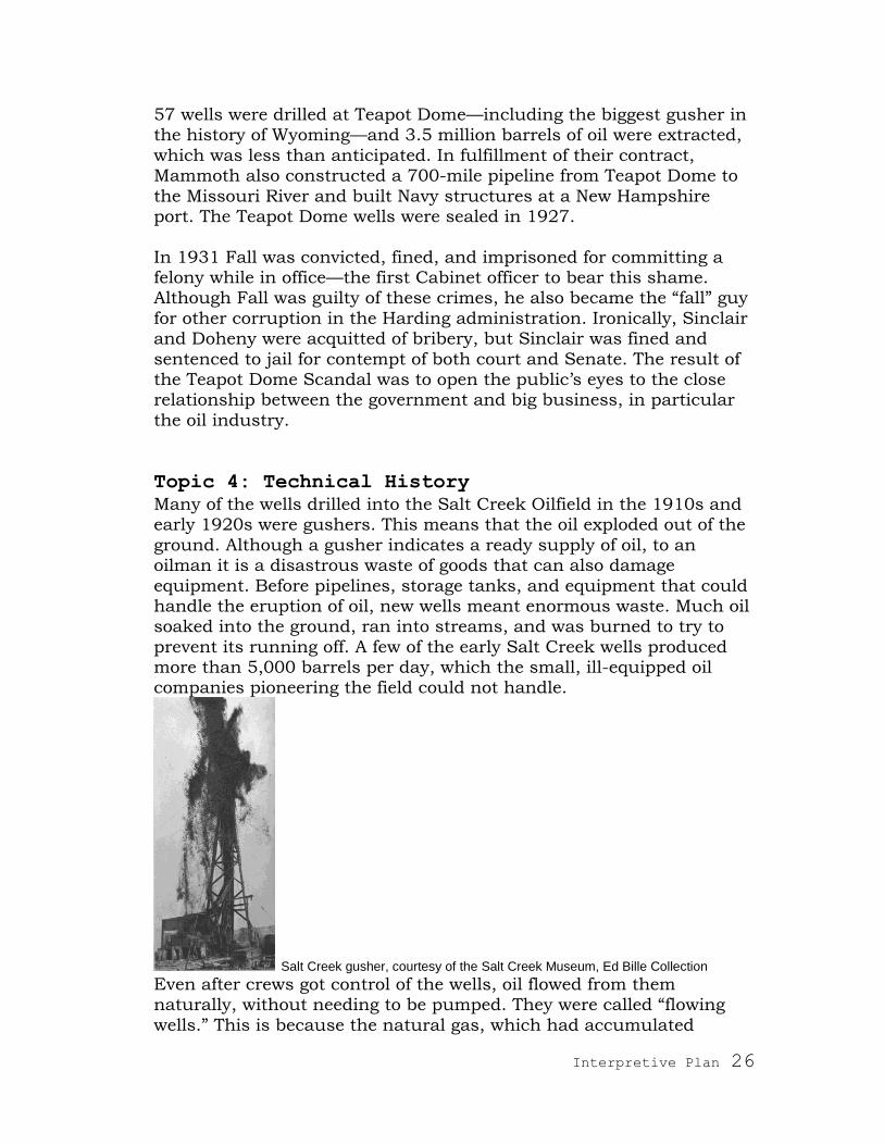
Many of the wells drilled into the Salt Creek Oilfield in the 1910s and early 1920s were gushers. This means that the oil exploded out of the
ground. Although a gusher indicates a ready supply of oil, to an oilman it is a disastrous waste of goods that can also damage
equipment. Before pipelines, storage tanks, and equipment that could handle the eruption of oil, new wells meant enormous waste. Much oil soaked into the ground, ran into streams, and was burned to try to
prevent its running off. A few of the early Salt Creek wells produced more than 5,000 barrels per day, which the small, ill-equipped oil companies pioneering the field could not handle.
Salt Creek gusher, courtesy of the Salt Creek Museum, Ed Bille Collection Even after crews got control of the wells, oil flowed from them naturally, without needing to be pumped. They were called ―flowing
wells.‖ This is because the natural gas, which had accumulated

Interpretive Plan 27
underground with the oil pressurized the oil, propelling it to the surface like an artesian well.
In 1916 the Midwest Refining Company began plans to collect this
residual gas. The company built a series of gas plants, booster stations, and pipelines and initiated this secondary line of production, one of whose byproducts was natural gasoline, which was added to
gasoline refined from oil. As automobile ownership increased in the following decades, gasoline production became more valued, and more uses were developed for natural gas, making natural gas treatment a
significant part of company revenues.
As the oil industry in this area grew from its beginnings in the 1890s, so did production, until it hit its apex in 1923 with more than 35 million barrels extracted in one year. This represented 5% of the total
US output, making Salt Creek the richest field in the US. The fall of production in 1924, however, signaled that gas pressure was
decreasing along with the oil supply. Once the oil stopped naturally flowing to the surface, wells would have to be pumped. Instead of putting every well (and there were thousands of wells) on its own gas
engine pump, the Midwest Refining Company decided to use electric pumps and to power them from a central plant. For this purpose, the company built a massive, steam turbine, gas-fired electric plant a few
miles north of Home Camp (later known as the town of Midwest)—which also powered the community and artificially lighted the first
night football game in history in 1925. By the end of 1925, practically every well in Salt Creek was ―on the pump.‖ The plant also powered the drilling of new wells. Salt Creek was one of the first and possibly
the largest totally electrified field in the US.
If you detour to see the old power plant, notice its gray color. The concrete used to build it substituted local gray shale (Haydite) for
sand and gravel, which were less available. This sturdy structure still

Interpretive Plan 28
stands but has been transformed into an agricultural building. To save precious gas (now highly valued) for other uses, the plant was
closed in 1958. Since then, power for the well pumps is supplied from the coal-fired plants, such as the Dave Johnston electric plant near
Glenrock. The dense network of power poles and cables continue to appear like porcupine quills on the landscape.
The appearance of the oilfield continually changes. When thousands of tall wooden derricks covered the land, Salt Creek was described as
a ―forest of derricks.‖ The derrick was one component of a cable tool rig, which was used through the mid-1930s to drill oil wells. The
wooden structures were left in place even after drilling was completed. One of these has been reconstructed in Casper at the corner of First
and Poplar streets. Wells drilled beginning in the mid-1930s were marked by lighter metal derricks, which belonged to rotary drilling systems. One of these can be seen at the intersection of highways 387
and 259 in Midwest. As wells went on the pump, pumping equipment replaced drilling equipment. The iconic silhouette of pump jacks was
identified with oil wells in the last half of the 20th century. These are now giving way to underground extraction systems, which will further reduce the visual impact of the oilfield by removing pump jacks and
power lines.

Interpretive Plan 29
Metal oil derrick, Midwest
At the beginning of the Salt Creek boom in the early 1910s, the anticipated life of the wells was 20 years. However, more than 100 years later, they are still producing oil. Cumulatively, the Salt Creek field has produced close to seven hundred million4 barrels of oil. To
accomplish this staggering number, new techniques have
continuously been applied to keep up production. Although many underground pools of oil have been tapped dry, a considerable amount of oil saturates surrounding layers of sand and rock. Geologists
believe that more oil remains underground trapped in the rock and sand than has been harvested. The objective of secondary and tertiary recovery techniques is to release oil from these surrounding layers.
In 1927 (or 1926, depending upon the source) Midwest Refining
Company began injecting gas back into the ground to repressurize wells. The technique was called gas drive. To further encourage oil flow, the Midwest Gas Plant, which collected gas from wells, pulled gas
through the lines, creating a current that drew oil with it. In 1955 water flooding was introduced, which quadrupled a well‘s output.
Injecting water into the ground forced oil upward through pores in the rock formations. Also at this time the hydrafrac process was
introduced. To release oil from tight sands, fractures in the oil sands
4 In early 2011, the current cumulative number is 688,367,307 barrels.

Interpretive Plan 30
would be created by forcing more sand down the outer casing of a well. A new method tried in 1958 was the fire drive. In this process, a
burner was lowered underground to the level of the oil sands. Heat thinned the oil and loosened it from the sand. A twenty-first century
method of recovery (called an EOR for enhanced oil recovery), which is used extensively at Salt Creek, injects carbon-dioxide into the ground. Similar to the gas drive technique practiced earlier, this method
pushes oil trapped in rock toward previously drilled wells and repressurizes the oil, making pumping unnecessary (hence the
removal of pump jacks and power lines to them in the Salt Creek field). The CO2 used is a byproduct from natural gas processing that would otherwise be released into the atmosphere. While decreasing
the state‘s overall CO2 emissions, this process has breathed new life into the century-old oilfield, increasing output by 600%.
Where does the oil go once it is extracted from the ground? At one time, most of the oil was piped to Casper‘s many refineries through
multiple pipelines. With most of these refineries closed now, the oil is pumped via a vast network of underground pipelines to numerous refineries in multiple states, where it is refined via heating, distilling,
and cooling processes into commercial products: gasoline, kerosene, lubricating oils, petroleum jelly, heavy greases, paraffin, and coal tar.
Topic 5: Geologic History
The same geologic activity that shaped Wyoming‘s rugged mountains and basins also endowed these features with rich mineral deposits and transformed ancient plants and organisms into such fossil fuels
as petroleum, coal, and natural gas (methane). By understanding how features of the landscape were formed, geologists can predict locations of minerals. For example, before drilling for oil in the Salt Creek field,
geologists and other people versed in ―reading‖ landforms had speculated the presence of oil here based on the topography of the
site. Salt Creek oil derives from Cretaceous sea life: microscopic algal
plants called diatoms that lived 150 million years ago in seawaters that covered this area. When they died, they collected on the sea floor
and were buried by layers of sand and sediment. As more layers of detritus built up, the diatoms were buried deeper underground. A combination of pressure from above and heat from the earth‘s core
transformed the plant material first into a waxy substance known as kerogen and from there into gas and oil.
The Salt Creek oilfield is located in the southwest corner of the Powder River Basin, a major depression in the earth‘s crust. This depression

Interpretive Plan 31
was caused by the rise of the Big Horn Mountains, which began 60 million years ago due to compression of the earth‘s crust.
Compression also caused folds (hills and valleys) in the floor of the basin. Elevated folds (hills) such as these are called anticlines.
The arched shape of an anticline forms a natural trap for hydrocarbons; therefore, geologists exploring for oil and gas look for
anticlines. Oil and gas are lighter than rock and water (think of oil floating on the top of water). From the deep levels underground where oil and gas form, they tend to migrate slowly upward through
permeable layers of rock (rocks that allow fluids to pass through them). When they are trapped beneath a layer of impermeable stone,
they accumulate to form a pool.
Source: http://www.fife-education.org.uk/scienceweb/Resources/science_SG/ Hot_Potatoes_SG_Science/Energy_General/Types_of_oil_reservoirs.htm

Interpretive Plan 32
Aerial view of Teapot Dome anticline, from Encyclopedia of Earth
The Salt Creek field is a classic anticline. Being oval in shape, this
type of anticline is also called a dome. It measures 9–10 miles north to south by 3.5–5 miles east to west. The soft, porous stone that capped the anticline has eroded away, leaving a flat surface of impermeable
shale encircled by a horseshoe-shaped escarpment of Shannon sandstone (a remnant of what eroded from the top of the dome).
Locally called the rimrock, this escarpment of sandstone is embedded with marine fossils. To a geologist, such an escarpment is an indication of possible pools of oil down below. Oil and gas accumulate
under the dense shale (called Cody Shale). You can drill through the shale anywhere in the 20,000 acres of the Salt Creek field and find oil.

Interpretive Plan 33
Media Plan and Recommendations This interpretive plan will be used to guide the development and design of the media suggested below. The first two items are funded
and will definitely be produced. The following items are recommended to solidify and amplify the trail, funding provided. Rough price ranges
are provided for yet-to-be-funded media. They are based on other projects and range in complexity and size of product.
1. Exterior Interpretive Sign Series
Six exterior interpretive signs will develop the topics and some of the
subtopics described above. They will include text, photographs, diagrams, and maps. They will be located along the trail at existing
locations for pulling off the road. Please see map, below, for proposed sign locations and associated topics.
Four of these will be produced in color in fiberglass or high-pressure laminate. Two will be classic brown signs. The supports for all six
signs will be themed with an oilfield icon (such as an oil derrick) to unify the series and attract passersby.
Because visitors to the byway may be entering from any of three points along the trail (southbound 87/I-25; westbound 387; northbound 87/I-25), the trail cannot have a defined beginning and
end. It is recommended, therefore, that all signs include a small trail map indicating ―you are here‖ and marking the locations of the other
signs. The route defined on the map includes excursions through the towns
of Edgerton and Midwest (including the Salt Creek Museum), which are the most significant remains of the oilfield‘s heyday. It also
includes excursions to Teapot Dome, the Midwest Power Plant, the Midwest Cemetery, and related sites in Casper (reconstructed timber oil derrick, terminus of the old Salt Creek Highway, former Amoco
tank farm, and former Amoco refinery). Highway Approach Signs
It is recommended that the Wyoming Department of Transportation (WYDOT) or other agency provide signs indicating the path of the trail,
at least at turn-off points along Interstate 25 (at highways 259 and 387) and possibly at the junction of the Salt Creek Highway with I-25
and along the Yellowstone Highway where it meets the Salt Creek Highway. It would also be helpful if small markers were installed along the routes indicated through the towns of Midwest and Edgerton.

Interpretive Plan 34
Existing Signs
It is further recommended that the existing brown sign (sited at Sign location 2) be removed. Though thorough and well written, the contents of this sign are being addressed in the new sign series,
making the material redundant. Also, the sign will stylistically not match the new signs. Furthermore, with two of the new signs being sited here, the pullout may become crowded.
The six sign topics / locations include:
Sign location 1: The Tate Pumphouse Trail Center parking lot along
Platte River Parkway in Casper: this site offers visibility from Yellowstone Highway and a safe place to park. It is also next to the historic Tate Pumphouse, which supplied North Platte River water to
the Amoco refinery located directly across the river from the site. It is also within view of the reconstructed wooden derrick and is near the terminus of the old Salt Creek Highway and the old tank farm. It is
also next to a hike and bike trail, Casper Whitewater Park, and public restrooms.
Sign topic 1: • Development of refineries in Casper to process the oil
• Development of modes of transporting oil to the refineries in Casper
• Transformation of Casper from a sheep town to the Oil Capital
of the Rockies
TMDA and the SHPO have discussed with the Platter River Parkway Trust the possibility of locating the sign here. The Trust is amenable to the idea. Thematically the site is a strong one, as it illustrates many
aspects of the story and it recognizes the significant role that Casper played in the Salt Creek story. Located 40 miles from Salt Creek
Oilfield presents both challenges and extended outreach opportunities to the Casper community.
Two solutions for coping with the site‘s distance from the oilfield are: 1) The interpretive panel will be mounted in the same silhouetted derrick that visually ties together the sign series. 2) The provision of a
trail sign (highway approach sign) along Yellowstone Highway indicating the mining byway will identify the site with the trail.
Sign location 2: Existing pull-out along highway 259 near the entrance to Teapot Dome (Naval Petroleum Reserve #3). Due to the paucity of
safe, existing pull-outs, we recommend placing two signs at this location.

Interpretive Plan 35
Sign topic 2: History of Salt Creek Oilfield development and complex battle for ownership (from placer mining to leasing and
from competition to unitization).
Sign topic 3: Teapot Dome scandal
Sign location 3: At the entrance to the playing field at the corner of highways 259 and 387 in Midwest. Across 387 from this site is a
reconstructed metal oil derrick with an interpretive panel. Diagonal to the proposed site is the former location of a SHPO brown sign, which
has been removed. WYDOT requested that the new sign not occupy this problematic spot.
Sign topic 4: Technical history: • Changes in methods of drilling and extracting oil and gas
• The current tertiary recovery method in use • How and where oil is transported
Sign location 4: The corner of Highway 387 and N Second Street in the
city-owned Lions Park. The Edgerton Town Council has voted to allow this placement and has offered to remove the old Lions Club sign, which currently occupies the prominent corner of the intersection.
Parking is available along N Second Street, and the park provides a fenced area for families to play and picnic. An alternate location for this sign is just west of here in the parking lot of the Teapot Motor
Lodge, 727 Highway 387 in Edgerton. Already designed as a pull-out, this property belongs to local contractor, Bill Chapman, who has
consented to allow a Black Gold Byway sign to be placed on his property.
Sign topic 5: • How geologists recognized that Salt Creek was an oilfield before
drilling here • Why oil collects in anticlines • How crude oil is formed
Sign location 5: Salt Creek Museum, 531 Peake Street, Midwest.
Although this location is off the highway and therefore exposed to limited traffic and visibility, the museum is well sign-posted, and the
museum director, Sandra Schutte, is very desirous of having one of the signs located there. If this site is deemed to be too remote, the alternative will be to place two signs at Sign location 3. See list below
of other sites considered.
Interpretive Plan 36
Sign topic 6: Salt Creek society: boom towns (the people they
attracted and the lifestyles maintained here) and ghost towns (the few people who remain)
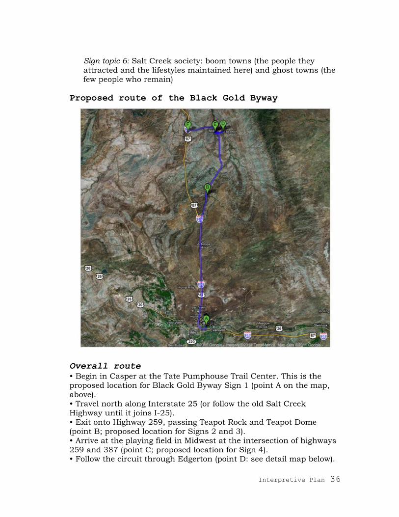
Proposed route of the Black Gold Byway
Overall route
• Begin in Casper at the Tate Pumphouse Trail Center. This is the proposed location for Black Gold Byway Sign 1 (point A on the map,
above). • Travel north along Interstate 25 (or follow the old Salt Creek Highway until it joins I-25).
• Exit onto Highway 259, passing Teapot Rock and Teapot Dome (point B; proposed location for Signs 2 and 3).
• Arrive at the playing field in Midwest at the intersection of highways 259 and 387 (point C; proposed location for Sign 4). • Follow the circuit through Edgerton (point D: see detail map below).

Interpretive Plan 37
• Return to Midwest and follow the circuit through Midwest (point E: see detail map below).
• Return to 387 and follow this to I-25.
Circuit through Edgerton
• Traveling east on Highway 387, exit onto County Road 117 (point A on the map above), which becomes Center Street. • Turn left onto Second Street (point B).
• Turn left again onto 387 (point C, the proposed location for Sign 5). • Return to Midwest.
Interpretive Plan 38
Circuit through Midwest
• Traveling west on Highway 387 from Edgerton, go straight at the intersection with Highway 259. You will be entering Midwest on Lewis
Street. • Turn left onto Ellison Avenue. • Turn right on Stock Street.
• Turn left again on Ellison Avenue (point B on the map above). As this street bends westward, notice the stately Lodge Hall which
remains from Midwest‘s heyday. This street also overlooks the playing field, below (south), which appears in many historic photos. Notice the ample, old, rusted warehouse at the end of this street (point C on the
map above), which also dates to the early 20th century. • Turn right at the end of this street onto Fitzhugh Road.
• Turn right on Peake Street. • At the municipal complex, turn left onto C Street.
Interpretive Plan 39
• Located mid-block within the municipal complex is the Salt Creek Museum (point D), which is the proposed location of Sign 6.
• Turn left onto Navy Row. • Turn right onto Fitzhugh Street.
• Veer right at County Road 116 (point F), which becomes Light Plant Road. • Turn left onto 387 (unless detouring to the former Power Plant).
• Continue west to I-25, passing Midwest Cemetery.
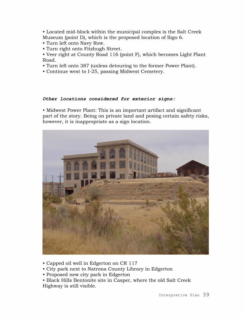
Other locations considered for exterior signs:
• Midwest Power Plant: This is an important artifact and significant
part of the story. Being on private land and posing certain safety risks, however, it is inappropriate as a sign location.
• Capped oil well in Edgerton on CR 117
• City park next to Natrona County Library in Edgerton • Proposed new city park in Edgerton
• Black Hills Bentonite site in Casper, where the old Salt Creek Highway is still visible.
Interpretive Plan 40
2. Brochure
This colorful, folding brochure will map the final route of the Black
Gold Byway with suggested detours. It will also include photographs and text that develop interpretation for the byway‘s topics. This brochure can be distributed through state, regional, and local tourism
channels in order to make travelers aware of the trail and to accompany them on the trail.
TMDA has contacted Aaron McCreight and Darlene Matz of the Casper Area Convention and Visitors Bureau. They lend their support to the
project and observe that many visitors already ask about the oilfield. Their office is an example of a good placement for the brochure.
3. Website
With most travelers planning their trips using the Internet, a website
is a strong method for building awareness of the Black Gold Byway. It is useful for planning trips and orienting visitors. It also provides information to those unable to experience the byway in person.
The website should provide the Black Gold Byway route map and
signal locations of interpretation. It is also a venue for unlimited additional information about the byway and the history of the region. For example, it could include:
• a virtual tour of the trail • catalogs of photographs, both historic and recent
• a series of historic maps that show the development of the oilfield, the towns, the refineries, and the modes of transportation over several decades
• video clips such as flyovers and interviews • recreational opportunities • links to related museums, chambers of commerce, Wyoming Office
of Tourism, and other partner organizations in the region • links to other Wyoming Historic Mine Trails and Byways
(see also Downloadable, Portable Resources, below) If funds will not be available for frequent website maintenance, the
site could be designed to require minimum upkeep (for example, by avoiding changing information such as road conditions and museum hours).
Cost estimate: $8000 to $16,000, depending upon website complexity

Interpretive Plan 41
4. Audio Tour
Develop an interpretive audio tour to accompany drivers along the
Black Gold Byway. Not only would this interpret significant sites along the route, but it could also provide a considerable amount of related material. Segments could have a thematic focus (like the roadside
signs) or address what travelers will see as they drive. While a sign has only a few seconds to capture and keep readers‘ attention, audio tour listeners are captive for longer periods of time. Therefore audio
tours can include more information, as well as oral histories (such as those collected by Professor Ebba Stedillie‘s students at Casper
College), music, and the sounds of drilling and pumping machinery. This audio tour could be downloadable as a pod cast (in which case it
could become a video tour as well), broadcast over local radio, or dial up from a cell phone (in which case separate segments would be
developed for each sign location). Cost estimate: $15,000 to $35,000, depending upon length and
complexity
5. Animated Film
Ed Bille writes: ―When a driver broke over 40 mile hill, at the south
edge of the field on the Casper highway, a sight like this [pictured] suddenly unfolded: far as the eye could reach, a great forest of
derricks by day—or the scintillation of thousands of lights at night. On a clear day, the snow capped peaks of the Big Horns loomed in the distance. The view of the Salt Creek oil field, encompassing 20,000
acres approximately nine miles long and three and one half miles wide, was one never to be forgotten. It was quite impossible to secure a picture that would do justice to the scene‖ (p. 58). While a static
photo cannot capture this scene, this animated film would bring the scene back to life. Set at day break, the film would recreate the vista of
a starry firmament that transforms into a forest of wooden derricks so that viewers can experience this otherworldly sight at night and in daylight. Using research and town or camp reconstructions developed
by Professor Jeff Sun‘s GIS students at Casper College, the animated film could also recreate life in the Salt Creek field and boom towns back in their 1920s glory. It could also illustrate the drilling of a well
using a cable tool rig and the rush of excitement of pulling in a gusher. The point of view could be a drive-by from the North & South
Railroad.
This film could appear on the website (media recommendation 3), on an exhibit kiosk (media recommendation 6), or as a downloadable,
portable resource (media recommendation 7).

Interpretive Plan 42
Cost estimate: $3,000–5,000 per minute of animated film
6. Exhibits (static and interactive)
Exhibits (both static and interactive displays) are a wonderful way to enrich the Black Gold Byway experience as well as to work as
outreach for the byway. A few ideas include:
• A drilling-for-oil interactive: race your friends to find the oil in
the anticline—and in doing so recreate the drilling madness and claims wars of the Salt Creek field in the 1910s–1920s. On a
large-screen television, competitors pilot their drilling equipment through or around obstacles to reach the oil pool. Winner gets all. A message of conservation could be included here.
• A topographic model of the Salt Creek Oilfield illustrating various
aspects of its history: a section showing geology and the tapping of the oil pool by wells, the battle for claims and changes in ownership, the proliferation of wells and oil camps in the 1910s–
1920s and their diminution since the 1930s, the development of various means of transportation from the field to Casper (and vice versa). These stories could be illustrated physically on the model
or could be projected onto the model through video and animation.
• A walk-in diorama supplemented with interpretive panels and possibly hands-on mining equipment. It could also include a
display case of artifacts. • A kiosk showing the animated film developed in media
recommendation 5
These exhibits could be included at venues along the byway, for example, the Salt Creek Museum in Midwest and the Mark J. Davis Branch Library in Edgerton (discussion with library pending). They
could also work as out-reach components for the byway through locations in Casper. TMDA spoke with Rick Young, museum director
at Fort Caspar, who said that he was open to having an interactive placed there. Exhibits in this museum already cover energy exploitation in the region, making this an appropriate venue.
Cost estimate: $10,000–$50,000 per exhibit, depending upon type of exhibit and complexity

Interpretive Plan 43
7. Downloadable, Portable Resources
The iPod, iPhone, & iPad revolution are making portable information
such as the Pod-cast broadly available. These media devices go far beyond providing audio. They allow for other types of information to be downloaded and carried. From the Black Gold Byway website, for
example, visitors planning their trip could download maps, photographs, video clips, audio essays, music, and even interactive games (developed on the topic of oil extraction).
Portable media device, source unknown
8. Official State Highway Map of Wyoming
We recommend approaching the Wyoming Department of
Transportation to request placement of the Black Gold Byway on the state highway map.
9. Design Standards and Recommendations
Include the Historic Mine Trail and Byway program logo and Wyoming State Historic Preservation Office logo on all signs and printed media. Once a template has been designed for the roadside signs, use this as
the basis for other graphic and media design.

Interpretive Plan 44
References Albanese, John. Geologist. Personal communication, October 8, 2010.
Appelgate, David. Book on history of refining in Casper held digitally at Western History Center, Casper College.
Bille, Ed. Early Days at Salt Creek and Teapot Dome. Casper: Mountain States Lithography Company, 1978.
Buck, S.P. ―Life in the Salt Creek Oil Field.‖ 1926. Typewritten
manuscript held at Western History Center, Casper College. Bureau of Mines. A Study of the Crude Oil Produced in the Salt Creek
Field Wyoming. Washington, Department of Commerce, 1929. Davis, Tim. ―Oil: An interview with Historian of Technology David
Nye.‖ Common Ground, Spring 2010, pp. 28-37. Hawkey, Susan. Petroleum Association of Wyoming. Personal
Communication, April 4, 2011.
Jamison, Claude E. The Salt Creek Oil Field, Natrona, County, Wyo. Cheyenne: State of Wyoming, 1912.
Jones, Nick. Geologist, Wyoming State Geological Survey. Personal communication, April 1, 2011.
Knowles, Ruth Sheldon. The First Pictorial History of the American Oil and Gas Industry 1859–1983. Athens (OH): Ohio University Press, 1983.
Lageson, David, and Darwin Spearing. Roadside Geology of Wyoming. Missoula: Mountain Press Publishing Company, 1988.
Larson, T.A. Wyoming: A History. New York: WW Norton & Company, 1984.
Lazarus, Bill. ―Salt Creek celebrates its 100 years of ups and downs in
the oil patch.‖ Star Tribune (Casper), August 13, 1989. McKinnon, Anne. ―BLM project calls for making Salt Creek oil field
historic site.‖ Star Tribune (Casper), July 11, 1983. Mokler, Alfred James. History of Natrona County Wyoming 1888–1922.
New York: Argonaut Press, 1914/1966. Mokler, Alfred James. ―Picturesque and Historic Wyoming.‖ Motor
Travel. Article held at Western History Center, Casper College. Pforzheimer, Carl H. & Company. The Salt Creek Oilfield Wyoming.
New York: Carl H. Pforzheimer & Company 1925. Roberts, Harold D. Salt Creek Wyoming: The Story of a Great Oilfield.
Denver: Midwest Oil Corporation, 1956.
Rosenberg Historical Consultants. Tour Guide: Salt Creek Oil Field, Natrona County, Wyoming. Casper: The Natrona County Historic
Preservation Commission, 2003. Schmidt, Thomas, and Winfred Blevins. History from the Highways:
Wyoming. Boulder: Pruett Publishing Company, 1993. Sorenson, Cheryl. Petroleum Association of Wyoming. Personal
communication, April 6, 2011.
Springer-Davis, Carmen, and Sandy Leotta. "Historic Sties of Salt

Interpretive Plan 45
Creek & Teapot Dome Oil Fields, 1889–1929." Paper, Casper College, 2008.
Thompson, Edith. ―When 20s Roared in Salt Creek.‖ March 15, 1970. Newspaper article held at Western History Center, Casper College.
Trexel. Historical Data Naval Petroleum Reserve No. 3. 1930, held digitally at Western History Center, Casper College.
United States Navy. Reports on Naval Petroleum Reserve No. 3, held
digitally at Western History Center, Casper College. Wall, J. Tom. Life in the Shannon and Salt Creek Oil Field.
Philadelphia: Dorrance & Company, 1973. Wegemann, Carroll H. The Salt Creek Oil Field Wyoming. Bulletin 670.
Washington (DC): US Government, 1918. Wilson, Warren. ―Oil field ecology ‗critical;‘ Salt Creek field studied by
BLM.‖ Star Tribune (Casper), July 14, 1981.
Yergin, Daniel. The Prize: The Epic Quest for Oil, Money, and Power. New York: Simon & Schuster, 1991.
Acknowledgements
TMDA thanks the following individuals from the Casper–Salt Creek community who have generously and enthusiastically shared their
photographs, memories, knowledge, resources, and ideas for this project—as well as their time in discussing these with us:
Jim Nations John Albanese Teri Hedgpeth, Western History Center, Casper College
Everett DeWitt, Anadarko Petroleum Corporation Jackie and Pinky Ellis
Jeff Sun, Casper College Ebba Stedillie, Casper College Sandra Schutte, Salt Creek Museum
Pat Busskohl, Wyoming Department of Transportation Jeanette Buelt, Rocky Mountain Oilfield Testing Center
Tom Anderson Bob King Suz Hawkey, Petroleum Association of Wyoming
Mark Watson, Wyoming Oil & Gas Conservation Commission Nick Jones, Wyoming State Geological Survey Jim Brown