
The Belize Valley Archaeological Reconnaissance · PDF fileThe Belize Valley Archaeological ....
102
The Belize Valley Archaeological Reconnaissance Project A Report on the 2003 Field Season Edited by Carolyn M. Audet and Jaime J. Awe
Transcript of The Belize Valley Archaeological Reconnaissance · PDF fileThe Belize Valley Archaeological ....

The Belize Valley Archaeological Reconnaissance Project
A Report on the 2003 Field Season
Edited by Carolyn M. Audet and Jaime J. Awe

- 2 -
Table of Contents 1. Surveying and Mapping at Baking Pot, 2003 3-14 Wm. Clay Poe, PhD, RPA 2. Excavations of Structure 215, Baking Pot, Belize 15-25 Laura McRae 3. Excavations of Structure 188, Baking Pot, Belize 26-34 Christine Dixon and Julie Hoggarth 4. Excavations of Structure 190, Baking Pot, Belize 35-52 Carolyn M. Audet 5. Archaeological Investigations And The Evaluation of 53-69 Sacred Spaces Construction in Stela Cave, Cayo District, Belize Reiko Ishihara and Cameron Griffith 6. Changes and Continuities in Ritual Practice at Chechem Ha Cave, Belize:
Report on Excavations Conducted in the 2003 Field Season Holley Moyes 70-102

- 3 -
Surveying and Mapping at Baking Pot, 2003
Wm. Clay Poe, PhD, RPA Sonoma State University
____________________________________________________________
INTRODUCTION During the 2003 field season the surveying and mapping component of the Belize Valley Archaeological Reconnaissance research project at Baking Pot was focused on the propagation of data based upon p reviously defined controls. A single new permanent control point was established and three structures and approximately 150,000 m2 of a residential area of the site were mapped with fine-grained topography techniques.
CONTROL POINTS During the course of the 2003 field season one additional Archaeological Map of Belize control point monument, 1038, w as established at Baking Pot in the vicinity of Structure 190. P oint 1038 w as established using dual frequency geodetic survey GPS receivers with one stationed at Control Point 1003 at Baking Pot and the other at Control Point 1038. An additional six temporary control points were established during the course of the season to facilitate the mapping of structures 190 a nd 215 a nd the mound and topographic mapping of the pastures to the northwest of structure 190. All of the control points positions were resolved to better than the Federal Geodetic Control Subcommittee two centimeter standard.1
Control Point 1038
WGS84 X Y Z 1038 105258.855 -6093987.109 1873458.414 Geographical Latitude Longitude Orthometric 1038 N 17°11'41.43821" W 89°00'37.62970" 53.487 UTM16N Northing Easting Height Above
Ellipsoid 1038 1902219.129 286186.815 49.196
TOPOGRAPHY The speed of the on-the-fly initialization and kinematic capabilities and the precision of the dual frequency rover receiver were used to generate fine-grained topography. Where possible the data were gathered by mounting the antenna on the roof of a four-wheel drive vehicle. Elsewhere the equipment was worn as a backpack. Where the canopy interferes with reception of the GPS signal, the laser rangefinder and
1 FGDC 1998a Table 2-1, Accuracy Standards, pp. 2f.

- 4 -
electronic compass were used to add an offset to the GPS signal, permitting the GPS receiver to be erected under open sky. The postprocessed precision of points gathered this way typically is in the range of approximately two to three centimeters.

- 5 -
UTM 16N WGS84 Belize Valley Archaeological Reconnaissance Project Plan: W. Poe 2000-2004 J. Conlon 1993-00 Survey:
W. Poe 2000-03 S. Hayes 2000-03
J. Conlon 1992-00 J. Ehret 1999-00 M. Johnson 1996-97 C. Griffith 1994-96 S. Brisbin 1992-94 P. Forbush 2003 C. Dixon 2003
$Z
$T$T$T$T
$T
$T
$T
#Y
#Y
#Y#Y
#Y#Y
#Y
#Y
#Y#Y
#Y#Y
1:10000
N
Baking Pot
100 0 100 200 300 400 500 600 700 800 900 1000 Meters
285000
285000
285200
285200
285400
285400
285600
285600
285800
285800
286000
286000
286200
286200
286400
286400
286600
286600
1902
200 1902200
1902
400 1902400
1902
600 1902600
1902
800 1902800
1903
000 1903000
1903
200 1903200
1903
400 1903400
Western Structure

- 6 -
Belize Valley Archaeological Reconnaissance Project Plan: W. Poe 2000-2004 J. Conlon 1993-00 Survey:
W. Poe 2000-03 S. Hayes 2000-03
J. Conlon 1992-00 J. Ehret 1999-00 M. Johnson 1996-97 C. Griffith 1994-96 S. Brisbin 1992-94 P. Forbush 2003 C. Dixon 2003
$T$T$T
$T
#Y
#Y
#Y
100 0 100 200 Meters N
Baking Pot
1:2500
285950
285950
286000
286000
286050
286050
286100
286100
286150
286150
286200
286200
286250
286250
286300
286300
286350
286350
1902
150 1902150
1902
200 1902200
1902
250 1902250
1902
300 1902300
1902
350 1902350
1902
400 1902400
1902
450 1902450
Str 215
Str 190
Str xxx

- 7 -
WESTERN STRUCTURE Slightly over a kilometer to the west of Group 1 stands a large solitary mound built on the edge of an ancient river terrace. A temporary reference station was established using Control Point 1038 as a reference. Using the temporary reference station as the location of one dual frequency GPS receiver, a kinematic file was recorded on the other dual frequency receiver in stop-and-go mode. Using this methodology twenty-six fixed stop-and-go points were recorded and 761 poi nts were recorded with sufficient accuracy to permit a 0.25 m . contour interval map to be constructed. Modern construction has affected the contour of the structure. There is a bulldozed path from the northeast edge of the mound to near the highest point and a shack has been constructed on that point. No stonework was noted and no surface collection was made.

- 8 -
10 0 10 20 30 40 50 60 70 80 90 100 Meters N
Baking Pot, Western Structure
1:1000
285040
285040
285060
285060
285080
285080
285100
285100
285120
285120
285140
285140
285160
285160
285180
285180
285200
285200
1902
980 1902980
1903
000 1903000
1903
020 1903020
1903
040 1903040
1903
060 1903060
1903
080 1903080
1903
100 1903100
1903
120 1903120
1903
140 1903140
0.5 m. contour interval UTM 16 N WGS 84 Baking Pot, Western Structure Belize Valley Archaeological Reconnaissance Project Plan: W. Poe 2004 Survey: W. Poe 2003 S. Hayes 2003 P. Forbush 2003

- 9 -

- 10 -
Structure 215 Structure 215 i s a small plazuela group on the western periphery of the site of Baking Pot. The topography of Structure 215 was mapped with a combination of GPS and Laser Rangefinder methods. Several large trees interfered with GPS signal reception. A temporary reference station was established using Control Point 1038 as a reference. Using the temporary reference station as the location of one dual frequency GPS receiver, a kinematic file was recorded on the other dual frequency receiver. Using this methodology 176 points were recorded to fixed solutions with precisions of less than two centimeters. Several of these points were selected as positions from which to shoot additional positions with the Laser Rangefinder. An additional 246 positions were recorded with the Laser Rangefinder for a total of 422 pos itions. The accuracy of the positions recorded was sufficient to permit a 0.10 m . contour interval map to be constructed. Modern construction has affected the contour of the structure. A bulldozer cut runs on an east –west axis through the group.

- 11 -
10 0 10 20 30 40 50 MetersN
Baking Pot, Structure 215
1:500
286000
286000
286010
286010
286020
286020
286030
286030
286040
286040
286050
286050
286060
286060
286070
286070
286080
286080
1902
240 1902240
1902
250 1902250
1902
260 1902260
1902
270 1902270
1902
280 1902280
1902
290 1902290
0.01 m. contour interval UTM 16 N WGS 84 Baking Pot, Structure 215 Belize Valley Archaeological Reconnaissance Project Plan: W. Poe 2004 Survey: W. Poe 2003 S. Hayes 2003

- 12 -
Georeferencing digital plans of Structure 190 Using stop-and-go techniques, GPS data were logged using the dual-frequency receivers on 143n tagged nails placed at frequent intervals across Structure 190. Over one hundred digital images were recorded each of which includes two to three of the tagged nails. The digital images can be imported to ArcView and georeferenced using the Image Analysis extension’s rubber sheeting facility. The images can be mosaiced as needed to create a georeferenced photographic plan of the structure.
Residential housemounds A combination of GPS and Laser Rangefinder techniques were used to map the natural contours and the locations of residential housemounds in a pasture to the northwest of Structure 190. The contour map included here shows a not quite 200 meter wide portion of Baking Pot from Structure 190 in the southeast extending for about three quarters of a kilometer to the northwest. It clearly shows the structure of the sacbe running north from Structure 190 and then curving to run along the south line of the drainage swale toward Group 2. T he contours of a number of residential mounds are clearly defined to the northwest of the swale. Some 7634 poi nts were gathered in order to construct this topographic map. Of those 2762 w ere laser rangefinder positions to record the topography of Structure 190. O f the remaining 4872, 146 w ere shots of the causeway taken with the laser rangefinder rather than GPS because of the canopy of a l arge tree, 1064 were GPS positions recorded walking and carrying the GPS unit as a backpack. The remaining 3662 were recorded from a moving vehicle.

- 13 -
Belize Valley Archaeological Reconnaissance Project Plan: W. Poe 2000-2004 J. Conlon 1993-00 Survey:
W. Poe 2000-03 S. Hayes 2000-03
J. Conlon 1992-00 J. Ehret 1999-00 M. Johnson 1996-97 C. Griffith 1994-96 S. Brisbin 1992-94 P. Forbush 2003
$T$T$T$T
$T
$T
#Y
#Y
#Y
#Y
#Y
#Y
#Y
#Y
#Y#Y
#Y
#Y
100 0 100 200 300 400 500 MetersN
Baking Potresidential area topography 2003
1:5000
285700
285700
285800
285800
285900
285900
286000
286000
286100
286100
286200
286200
286300
286300
286400
286400
286500
2865001902
100 1902100
1902
200 1902200
1902
300 1902300
1902
400 1902400
1902
500 1902500
1902
600 1902600
1902
700 1902700

- 14 -
C. Dixon 2003

- 15 -
Equipment
Dual-frequency geodetic surveyor GPS receivers
Manufacturer Trimble GPS Antenna
Trimble
Model 4000SSE Geodetic Surveyor Model Geodetic with ground plane Part No. 18292-01 Part No. 14177-00 Serial No. 3244A01763 Serial No. Firmware 7.29 Manufacturer Trimble GPS
Antenna Trimble
Model 4000SSE Geodetic Surveyor Model Geodetic with ground plane Part No. 18292-01 Part No. 14177-00 Serial No. 3610A14748 Serial No. 3017A00164 Firmware 7.29
Single frequency GIS surveyor GPS receiver
Manufacturer Trimble GPS Antenna
Trimble
Model 4000SE GIS Surveyor Model Compact L1 Part No. 18292-01 Part No. Serial No. 3301A02301 Serial No. Firmware 7.23
Laser Rangefinder
Manufacturer Laser Technology Model Laser Rangefinder Part No. 5,574,552; D390,483;
5,780.999; 5,790,244; 5,859,693
Serial No. i06015
Compass Module
Manufacturer Laser Technology Model Compass Module Part No. 5,589,693 Serial No. C001521

- 16 -
Bibliography Centre, Supplementary Report 15, 1979. Federal Geographic Data Committee (FGDC), Federal Geodetic Control Subcommittee 1998a Geospatial Positioning Accuracy Standards, Part 2: Standards for Geodetic
Networks, FGDC-STD-007.2-1998. Federal Geographic Data Committee (FGDC), Federal Geodetic Control Subcommittee 1998b , Geospatial Positioning Accuracy Standards, Part 3: National Standard for
Spatial Data Accuracy. FGDC-STD-007.3-1998. Intergovernmental Committee on Surveying and Mapping (ICSM), Australia 1997 Best Practice Guidelines, Use of the Global Positioning System (GPS) for
Surveying Applications, Version 2.0 - 1 November1997 National Geodetic Survey 1996 NAVSTAR Global Positioning System Surveying Engineer Manual, EM
1110-1-1003, 1 August 1996 United States Department of Agriculture (USDA), Forest Service, United States Department of the Interior, Bureau of Land Management 2001 Standards and Guidelines For Cadastral Surveys Using Global
Positioning System Methods, March 21, 2001. US Army Corps of Engineers, Engineering And Design 2000 Guidelines for Geodetic Network Surveys Using GPS, Including Federal
& Cooperative Base Network Surveys, User Densification Network Surveys, Gps Orthometric Height Surveys, DRAFT 4, May 15, 2000, National Geodetic Survey, N/NGS2, NOAA, 1315 East-West Highway, Silver Spring, Maryland 20910-3282, email: [email protected] or [email protected]

- 17 -
Excavations of Structure 215, Baking Pot, Belize
Laura McRae University of Winnipeg
___________________________________________
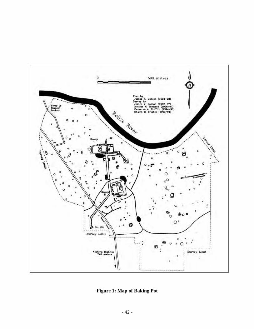
INTRODUCTION Baking Pot is an ancient Maya site located on the bank of the Belize River approximately 5 miles east of the modern day town of San Ignacio. The site of Baking Pot is formed by 2 large architectural complexes (Figure 1). Groups I and II are linked by a sacbe and surrounded by a multitude of household mounds and plazuela groups. Several structures in the surrounding periphery were excavated in the 2003 field season: the causeway terminus structure, a household structure directly adjacent to it, and the eastern structure of a plazuela group. This paper will focus on t he excavations of the latter. Three plazuela groups have been the extensively excavated at Baking Pot. While the most recent excavations at the Yaxtun Group did not yield evidence of an eastern structure, the others, including the Atalaya Group and the Bedran Group provide excellent comparative material. Structure 2 of the Bedran Group, located one kilometer west of the site core of Baking Pot, was the eastern shrine platform that contained almost all of the human interments and caches found at the group (Finlayson 1994, Conlon et al. 1994). Similarly, Moore recorded numerous caches and burials from the Atalaya Group, a large eastern platform located south of Group 2 (Moore 1999). Excavations of Structure 215 were intended to determine if this trend of ritual activity in eastern structures extended to other smaller plazuela groups at Baking Pot and to determine the nature of this ritual activity. EXCAVATIONS
Structure 215 is the eastern structure of a small 4 mound plazuela group, located approximately 100 m eters north-north west of Structure 190, a causeway terminus building, and 250 meters south west of Group 2. The western section of the platform rises 0.5 meters above the modern ground level. Excavations of Structure 215 commenced in July of 2003. S even excavations units were placed on c entral axis and front of the structure. Five units were placed in efforts to clear the front of the platform, one was placed in the plaza in front of the structure, and one was placed into the top of the platform. ARCHITECTURE

- 18 -
Only two phases of construction were uncovered during the 2003 s eason. The terminal phase was an extension of the existing penultimate platform; however the overall height of the structure was left unchanged. The penultimate phase of construction consisted of an L-shaped platform constructed of cut limestone blocks ranging in height from 30-50 cm (Figure 2). The bottom section of the L was located on the northern side of the plazuela group and faced west, with skinnier section on t he southern side. The northern section measured 270 cm long, while the southern part was only excavated for 70 cm due to a lack of time. No staircase was discovered, suggesting one of three possibilities: the staircase was located in the bulldozer cut, the height of the wall did not require the construction of stairs, or that access to the top of this platform was limited to staircases on the other structures. During its terminal phase of occupation, Structure 215 consisted of a single long platform constructed with three courses of cut limestone blocks. The once skinny part of the L in the penultimate structure was now filled in and a crude wall was constructed in line with the earlier wide section of the penultimate platform. The entire platform was covered with a layer of plaster that was not well preserved. While we did not discover any postholes, daub discovered in the collapse layers indicates that a perishable superstructure once stood atop the platform. Excavations revealed that the structure was at least 464 cm long. Years of plowing and a bulldozer cut located on t he southern side of the plazuela limited our ability to measure the entire length of the structure. Despite our efforts, the back wall was also not located, making it impossible to speculate on the overall size of the structure. BURIALS Eight burials were discovered in the fill of Structure 215. D ue to the extensive plowing of the field, the majority of the bones had been disturbed. However, they were all found to be situated on a north-south axis, in a prone position, with the head to the south. Burial 1 Burial 1 was located in Unit 3, approximately 5 cm below surface, on the west side of the structure. N o plaster floor was discovered above the interment, suggesting that the burial may be intrusive or it may simply have been destroyed by the plow. The skull was missing which also could be a result of plowing given the closeness of the burial to the surface. A single ceramic fragment found with the burial suggests that this individual likely dates to the Postclassic period. Analysis of the bones is being conducted during the 2004 f ield season so nothing is currently known about the sex or age of the individual. Burial 2 Burial 2 was located on top of the platform in unit 5, 21 cm below the surface. The individual was discovered facing west with the head to the south. Numerous artifacts

- 19 -
were discovered in association with this burial, including a bifacially flaked celt, 14 side notched obsidian blades, and 5 unmodified obsidian blades. The notched blades range in size from 8-10 cm, suggesting that they are not the small notched arrow points of the Late Postclassic period, however no similar obsidian blades have been uncovered from the site. No dateable ceramics were discovered with this individual, making it impossible to determine if the individual was interred at the same period as Burial 1 or if it was much earlier. Burial 3 Consisting of only a femur and a radius, Burial 3 was located in unit 3, level 2, directly above burial 1. The bones were located on an east-west axis, however given the disarticulated nature of the remains; it is likely that they have been moved by the plow. The discovery of these bones above Burial 1 s uggests that they also date to the Postclassic period; however the lack of dateable material and the lack of a sealed context make this difficult to determine. Burials 4 and 5 Burials 4 and 5 were located in unit 5, level 2 (Figure 3). These individuals were intermingled, making excavation and analysis difficult. Burial 4 consisted of only a few bones, however they appear to belong to a juvenile individual. Burial 5 appears to be in a flexed position, however only the femurs, a tibia, and a broken mandible were discovered in the ground. No grave goods or other dateable artifacts were discovered in association with these individuals. Analysis of these remains will be conducted during the 2004 field season. Burial 6 Burial 6 is located along the central axis of the structure (Figure 4). At a depth of 129 cm below datum 1 we uncovered skull fragments and a partial right clavicle. The material was positioned with the head to the south. In association with this burial we discovered 2 conch ear flares. They have 8 points and 16 incisions radiating out from the center hole. One ear flare measures 3.1 cm in length, and is 0.3 cm in width; the other 3.0 in length, and 2.9 in width. The pins that would have inserted into the flare measure 1.9 cm and 1.6 cm respectively (in length). The skull and mandible were not present; however we were unable to determine when these bones were removed. DISCUSSION AND CONCLUSION Although excavations at Structure 215 during the 2003 field season were limited, 6 burials were discovered. This mirrors what had been found at similar structures at the site. However, it was interesting that very few grave goods and no hi gh status caches were located. This was surprising considering the high quality items discovered at both Atalaya and Bedran as well as at the Yaxtun Group. Perhaps the individuals found interred in the eastern shrine were intrusive, and not members of the lineage that founded the group. However it is also possible that the plazuela group was occupied by people of lesser status than previously excavated patio groups. Future research will need to be

- 20 -
conducted both in the eastern structure as well as in the plaza and the other three platforms. Evidence of domestic activity was also recovered during our investigations. The remains include items used food preparation and farming, including chert bifaces, granite manos and metataes, chert hammerstones, and granite grooved stones. While it is clear that this structure was being used as an ancestor burial shrine, it is also likely that people were living and working above the bodies of their relatives.

- 21 -
References Cited: Audet, Carolyn M
2002 Excavations of Structure 198 at the Yaxtun Group, Baking Pot, Belize. In The Belize Valley Archaeological Reconnaissance Project Field Report. Submitted to the Department of Archaeology, Belize. E dited by Jaime J. Awe and Cameron Griffith.
Conlon, James M., Bobbi M. Hohmann, and Terry G. Powis 1994 Ruler or Ruled?: Status, Land Tenure, and Nucleated Settlement in the Western Periphery of Baking Pot, Belize. In The Belize Valley Archaeological Reconnaissance Project Field Report, the Sixth Season. Edited by James Conlon and Jaime J. Awe Finlayson, Kerri K 1994 Belize Valley Archaeological Reconnaissance 1994: Inter-Group and Intra-Group Relationships within the Belize Valley. The Bedran Mound Group, Baking Pot, Belize. Senior Thesis submitted at University of Michigan. McRae, Laura and Audet, Carolyn M
2002 Excavations of Structures 196 and 197, Baking Pot, Belize. In The Belize Valley Archaeological Reconnaissance Project Field Report. Submitted to the Department of Archaeology, Belize. E dited by Jaime J. Awe and Cameron Griffith.
Willey, Gordon, WR Bullard Jr., JB Glass and JC Gifford
1965 Prehistoric Maya Settlements in the Belize Valley. Peabody Museum of Archaeology and Ethnology Paper, Number 54. Harvard University, Cambridge.

- 22 -

- 23 -
Figure 1: Map of Baking Pot

- 24 -
Figure 2: Plan View of Structure 215

- 25 -
Figure 3: Burials 2, 4 and 5, all intermingled

- 26 -

- 27 -
Figure 4: Burial 6
Excavations of Structure 188, Baking Pot, Belize
Christine Dixon University of Colorado, Boulder
and Julie Hoggarth
University of California, San Diego ________________________________________________________
INTRODUCTION During the 2003 f ield season, the Belize Valley Archaeological Reconnaissance Project conducted research in several loci. Structure 190, the causeway terminus temple was intensively excavated, and several residential structures, including Structure 188 were tested. The height and width of this mound suggested that it was a small residential platform, similar to others tested in previous years (McRae and Audet 2003; Piehl 1999, 2000). Structure 188 is located approximately 20 meters south of the sacbe that connects Group 2 to the causeway terminus, Structure 190, and southwest of Group 2 (Figure 1). RESEARCH DESIGN Extensive research has previously been conducted in residential structures located in the periphery of Baking Pot, particularly at plazuela groups (Audet 2002, Audet and Awe 2000, Conlon 1996, Moore 1999). While some single residential mounds have been excavated, they have all been located on the eastern side of the site. Excavations at Structure 188, a long with concurrent excavations at other residential structures, will endeavor to illuminate residential patterns on the western side of the site. These patterns include gaining an understanding of the chronology of occupation, the functional use of the platform, and to define the orientation, size and shape of Structure 188. In order to achieve the desired objectives, two 1m x 4 m excavation units were placed along the central axis of the mound. Unit 1 was located on the northern side of the mound, while Unit 2 extended to the southern base of the structure. EXCAVATION RESULTS Lithics, ceramics, daub, and obsidian comprised the majority of artifacts encountered in the excavation conducted on Structure 188. The top layer of units 1 and 2 contained very small, fragmented pieces of ceramic and lithic. The small size of these artifacts, combined with the presence of what appeared to be rocks cut by a plow, indicated plow activity within the upper stratigraphy of this mound.

- 28 -
Unit 1 Unit 1 consisted of hard clay soil with mostly lithic, ceramic, and daub artifacts. Approximately 32 cm below the surface of Unit 1, e xcavators recorded the poorly preserved traces of the terminal phase plaster floor. The floor extended across the width of the entire structure to top course of the northern platform wall. T his wall was comprised of cut limestone blocks that averaged 20cm high by 28cm long. Excavation units were extended to the east and west of Unit 1 in efforts to continue following the northern wall. These extension units became Unit 1B to the west and Unit 1C to the east. Seven bifacial lithic fragments were found in the collapse of this wall, as well as some ceramic sherds and lithic debitage. Unfortunately neither corner of the northern wall could be located due to time constraints. Unit 1A was a 1m x 1m excavation area designated in the southern portion 60 cm north of the southern end of Unit 1. Unit 1A was set up to determine any earlier phases of construction associated with Structure 188 a nd find the depth of sterile soil. T he unit revealed lithics, ceramics, daub, and some faunal remains, as well as, 18 obsidian blade fragments, two metate fragments, some charcoal pieces, and two pieces of polished bone. Unfortunately, time constraints limited us from achieving our goals and future research will have to continue this excavation. Unit 2 Excavations in Unit 2 e xposed hard mostly clay soil containing lithic, ceramic, and daub artifacts. B oth the artifact assemblage and the soil from the upper layer are similar to that of Unit 1. Artifacts uncovered in Unit 2 i ncluded 13 o bsidian blade fragments, 1 bifacial blade fragment, 2 unifacial side-notched chert blade fragments, and 1 mano. The terminal phase plaster floor was located at the same level in Unit 1 as in Unit 2, and excavations were terminated at this level. The southern platform wall was located 8.5 m eters from the northern wall, and stood only two courses high. The unit was extended 120 cm to the east and 80 cm in efforts to follow the wall to its termination. Unfortunately, time constraints limited our search for the corners leaving us with little information about the size of the platform. DISCUSSION It is difficult to estimate the approximate size of Structure 188 due to the inability to locate a corner for either the northern or southern walls of the structure within the 2003 field season; however we can determine that the platform was 8.5 meters wide (Figures 2 and 3). No stairs were located on e ither side, leaving the orientation of the structure unknown. Future excavations will attempt to determine which side functioned as the front of the structure, perhaps giving us insight into the possible relationship of the sacbe with 188. The artifacts recovered from the excavation of Structure 188 s uggest that Structure 188 had a residential function. Artifacts included ceramic sherds, 45 obsidian blade fragments, 2 uni -facial side-notched chert blades, chert flakes and shatter, chert cores, 8 bi facial fragments, 2 m ano fragments, 2 m etate fragments , a nd 2 pol ished fragments of bones. Willey et. all (1965) expressed that in the Barton Ramie area typical

- 29 -
artifacts associated with household occupations consisted of: mano and metate fragments, utilitarian ceramics, obsidian blades, spindle whorls, and utilitarian chert bifaces. Many similar materials were present in the artifact assemblage of Structure 188 and offer partial evidence of residential function. Preliminary analysis of the ceramics recovered in these excavations indicated that these artifacts belong to the Spanish Lookout Phase of the Belize Valley type-variety system (Gifford 1965). Such an assessment of the ceramic materials tentatively dates the terminal occupation of this structure to the Late Classic Period (Willey, et. all 1965). Unfortunately the time limitations of the 2003 field season prohibited investigations into earlier phases of construction that might have been present at this structure. CONCLUSIONS Both the architecture and the artifacts recovered in the excavations of Structure 188 indicate that this structure had a residential occupation during the Late Classic Period. T o determine the exact size and morphology, as well as, the presence of any earlier phases of construction at Structure 188 requires further excavation. S uch excavation at Structure 188, as well as investigations of other residential groups, will provide a better understanding of both the residential occupation and an intra-site level of organization at Baking Pot.

- 30 -
References Cited Audet, Carolyn M
2002 Excavations of Structure 198 at the Yaxtun Group, Baking Pot, Belize. In The Belize Valley Archaeological Reconnaissance Project Field Report. Submitted to the Department of Archaeology, Belize. Edited by Jaime J. Awe and Cameron Griffith.
Conlon, James M., Bobbi M. Hohmann, and Terry G. Powis 1994 Ruler or Ruled?: Status, Land Tenure, and Nucleated Settlement in the Western Periphery of Baking Pot, Belize. In The Belize Valley Archaeological Reconnaissance Project Field Report, the Sixth Season. Edited by James Conlon and Jaime J. Awe Gifford, J.C.
1976 Prehistoric pottery Analysis and Ceramics of Barton Ramie in the Belize Valley. Memoirs of the Peabody Museum of Archaeology and Ethnology, Harvard University,Vol.,18.Cambridge, Massachusetts.
McRae, Laura and Audet, Carolyn M
2002 Excavations of Structures 196 and 197, Baking Pot, Belize. In The Belize Valley Archaeological Reconnaissance Project Field Report. Submitted to the

- 31 -
Department of Archaeology, Belize. E dited by Jaime J. Awe and Cameron Griffith.
Moore, Allan F.
1999 Microsettlement-Analysis in the Belize River Valley: Archaeological Investigations at Atalaya, a formal Patio Group at Baking Pot. Unpublished Ph.D. dissertation at the Institute of Archaeology, University College London, London.
Willey, Gordon, WR Bullard Jr., JB Glass and JC Gifford
1965 Prehistoric Maya Settlements in the Belize Valley. Peabody Museum of Archaeology and Ethnology Paper, Number 54. Harvard University, Cambridge.

- 32 -
Figure 1: Map of Baking Pot with Str. 188 highlighted

- 33 -
Figure 2: North Wall of Structure 188

- 34 -
Figure 3: Profile of Structure 18

- 35 -
Excavation of Structure 190, Baking Pot, Belize
Carolyn M. Audet
Vanderbilt University _______________________________________________________
INTRODUCTION During the 2003 field season the Belize Valley Archaeological Reconnaissance Project, under the direction of Dr. Jaime Awe, excavated and consolidated Structure 190. This small temple is located at the southern end of a causeway, approximately 380 meters southwest of Group 2 (Figure 1). After the mound was cleared of flora, excavations commenced on the northern side (the side facing the causeway) of the mound and were extended across the entire structure. This structure was chosen for investigation due to its location at the end of the causeway. During the 2002 season, BVAR excavated Structure 209, a platform located alongside the causeway only 20 meters from Group 1 (Audet and Awe 2004; 2003). This platform contained the remains of three elite individuals, and appeared to have functioned, at least in part, as a funerary shrine. We wanted to investigate a second causeway related structure, and Structure 190, l ocated at the southern terminus of the main sacbe at Baking Pot appeared to be a good choice for comparison with our previous research. HISTORY OF RESEARCH ON CAUSEWAY TERMINI STRUCTURES Causeway associated structures are relatively common throughout western Belize and the Peten province of Guatemala. There appear to be two types of these structures. Both are located at the ends of causeways; however one is found in the site periphery away from the site core, while the other is located at the entrance to the monumental center. Cheetham (2004) has noted that in this area there does not appear to be any trends in the orientation or location of these structures within the site. Several causeway termini structures have been documented in the Belize Valley (Figure 2). At the site of Cahal Pech a large terminus group was located and excavated by David Cheetham (Cheetham 2004). At Caracol, numerous terminus groups have been documented and excavated by the Chases and Sonja Schwake focused on the terminus structure at Xualcanil (ibid, Schwake 1999). While the Xualcanil and Cahal Pech examples strongly suggest a ritual function for these structures, several of the termini groups at Caracol appear to have a more domestic or economic role in the community. Cheetham notes that when these architectural features are located within one kilometer of the site core they tend to be ritual in nature, and only after this distance do these groups display signs of residential function. Both causeway termini structures at Baking Pot are located within this one kilometer range, suggesting that our examples likely served a

- 36 -
ritual function. However we would like to determine more specifically what type of ritual function they played. Understanding the function and meaning of a Maya structure is a difficult challenge. Similar studies have employed the use of almost all artifacts, features, and caches in an effort to better understand the importance of a particular structure within a community. Only through a complete study of the location, quality of architecture, stone monuments, architectural styles, and associated caches and burials can we begin to see these termini as the sacred places they once were. ARCHITECTURE While our testing inside the terminal phase of occupation was limited to only two units, it is clear that there were at least three main phases in the construction of the temple. The last two construction phases dates to the Tiger Run Phase or Late Classic Period, while the first dates to the Hermitage Phase, or Early Classic Period. Structure 190/1st was likely only a low platform with the large altar (70 cm high and 130 cm wide) at the center (Figure 3). Structure 190/2nd included several modifications of the first construction. The platform floor was raised by 30 cm and high masonry spine walls for the creation of at least one room were constructed around the altar. While we only exposed a small section of this earlier phase of construction, it appears that we cleared part of a small room. The height of the southern wall was over 160cm, while the spine walls to the north were slightly shorter, measuring only 140cm in height. The walls do not appear to be vaulted. This room was oriented in the same direction as the terminal phase architecture, with the altar located in the doorway leading into this room. It is interesting, however, that this doorway would have been partially blocked by the altar. The altar rose 40 cm above the stucco floor in the center of the doorway. There are at least two possible explanations for its location. Perhaps this opening was not used as a doorway and there were other entrances into this room, or people were allowed to walk over this alter as necessary. No further information about this phase of construction was encountered in our test excavation. During our two month field season, the terminal phase architecture was completely exposed (Figure 4). Several penetrating excavations were placed along the central axis and a single unit was placed in the floor of a small room appended onto the western side of the structure. Our excavations exposed a 3 meter high platform topped with a two room masonry superstructure. All of the platform and superstructure walls were constructed of small cut limestone blocks that were likely mortared together and covered with lime plaster. None of the rooms were vaulted, and based on the amount of collapse uncovered, the walls were likely no more than 70 cm (or 7-8 courses) high when the structure was occupied. A small two step outset staircase with an uncarved stela placed in its center was appended to the northern of the structure. Four terraces were discovered on the northern side of the structure while two higher terrace walls were located on the southern side. Entry into the front room was limited to a central doorway 238.5 cm wide. This doorway led into a room 665cm long (east to west) and 115 cm wide (north to south). On

- 37 -
the southern side of this room were three doorways leading into a second room. The central doorway connecting the two rooms was narrower than the main entrance, measuring only 150 cm wide. It led into a smaller, narrower room that was situated 30 cm (two steps) lower than the larger room to the north. This chamber was only 440 cm long and 90 cm wide. Two additional doors leading into this back room were located on the eastern and western ends. These doorways were small, measuring only 70cm wide. There was no exit leading out the southern (or back side) of the structure. The southern side of the structure was constructed of two large terraces, each measuring 120cm and 90 cm high respectively. The upper terrace was built on a 130 degree angle, in contrast to the 90 degree angle which the rest of the terrace and superstructure walls were constructed. No additional architectural features were uncovered on this side of the building. Appended to the western edge of the building was a small room, measuring 160 by 120 cm wide. The walls enclosing this small addition were low, only 1-3 courses high and it is probable that the rest of the wall height was once constructed of wattle and daub. Inside this room, excavators discovered the butt of a stela (Stela 2) in situ. Only 30 cm of this stela could be seen above the terminal phase floor, however, its butt extended almost a meter below the plaster surface. While Structure 190 w as not composed of a vaulted superstructure, the quality and height of the superstructure and platform walls is equivalent to the construction of the elite palace complex and site core temples at Baking Pot. This may suggest that elites both oversaw the construction and the management of whatever ritual activities were undertaken at the structure. MONUMENTS AND ASSOCIATED DEPOSITS Along the primary axis of the structure, facing the causeway to the north, we discovered the butt of a stela (Stela 1) in situ. The stela was placed in an outset stair block, directly in front of the first terrace. The top section of the stela was broken into several pieces that were located at the base of the structure. Around the base of the outset staircase we encountered a large deposit of broken ceramic dishes, vases, bowls and censers. Several thousand partially complete vessels were encountered. The pottery dates to the Spanish Lookout phase and predominantly includes types affiliated to the Belize Ceramic Group. Very few jar fragments or black slipped vessels were discovered, and there were no animal remains, chert flakes or manos and metates. One dozen partially complete or complete obsidian blades were also located in the deposit. We believe that this feature was ritual in nature due to its location around the base of the stela, the uniformity of the ceramic types within the deposit, and the lack of domestic debris. While all the ceramic date to a single ceramic phase, it is clear from our excavations that these ceramics were placed at the front of this temple over a short period of time. There were no thick layers of dirt between different ceramic deposits; however its thickness and the number of vessels suggest that this even did extend for some period of time. The fact that the deposit was never cleared from the front of the structure suggests that this temple ceased to be used some time during the Terminal Classic Period, around the time of this “termination” event.

- 38 -
Excavations under the stela yielded a hole the plaster floor directly under the monument. While we expected to find something in this perforation, whatever was put into the gap was either removed or was perishable. Soil samples were taken, however no tests have yet been performed. A second stela was discovered in a small room on t he western side of the structure. Buried under the base of the stela were the remains of at least 26 modeled censers that date to the Late Preclassic or Early Classic period (Figure 5). These incensarios have out-flaring rims and a flat base. All have a single face, including eyes, nose, and teeth. Flanges are located on t he sides of the vessels and typically have two modeled circles impressed into them. Fifteen fragmented pieces of polished jade beads were recovered just above the ceramics. In addition, fragments from at least 10 red slipped dishes and an unslipped miniature olla were uncovered. A large altar, 134 c m in diameter and over 70 cm high was discovered in association with the first construction of Structure 190 ( Figure 6). The altar was constructed with cut limestone blocks that lined both the outer face of the monument and an inner circle within it. The inner section was filled with limestone rocks and alluvial soil. Under the floor the altar rested on we discovered the remains of 186 ceramic vessels, over fifteen hundred broken fragments of jade, and several jade beads. The majority of these ceramic vessels were miniature bowls and ollas that were placed upside down. However, a few bowls and dishes were also recovered. Preliminary assessment of these ceramics suggests that they date to the transition between the Late Preclassic and the Early Classic period (Culbert 1993; Gifford 1976). Excavations inside the altar yielded the remains of 26 miniature bowls, including nine placed in a lip-to-lip orientation (Figure 7). At least one dozen complete sets of finger bones were found in the matrix of the altar, the majority inside the lip-to-lip pairs. The rest were found throughout the fill, at the same level as the ceramic finger bowls. This early deposit suggests that when this structure was built it w as initially constructed as a sacred location. The later deposits discussed below indicate that the importance of this temple continued throughout the Late Classic period. BURIALS Four individuals were discovered within the structure, including the remains of two adult skulls, a neonatal baby, and a headless adult individual. All are likely offerings deposited inside the structure during ritual activities or during periods of construction. All of the human remains were deposited during the Tiger Run Phase / Late Classic One and all were located along the central axis of the structure. Burial 1 was located in the center of the structure, under the terminal phase plaster floor of room 2. It contains a very young infant or premature baby located in association with several partially complete Mountain Pine Red dishes and a fragment of large hollow figurine head (Figure 8). This figurine has a bird located in the middle of its forehead, nose and ear plugs, and six horns extending from below the ears on each side to the top of the head. Further analysis needs to be conducted to determine if this figurine was representing a specific deity or individual. Burial 2 w as located just north of Stela 1 i n a north-south orientation. This skullless individual was an elderly (over 65) female, placed in a supine position with her

- 39 -
feet slightly elevated (Kokkalis, personal communication 2004). Her skull was missing, suggesting that she was either decapitated or her head was removed after interment (Figure 9). The skull-less remains were interred with two unslipped bowls that were placed in a l ip-to-lip formation. These ceramics were discovered just east of the individual’s feet. Inside the lip to lip we discovered evidence of burning as well as two bones, cut sphenoid skull bones from an individual. These bones have a unique feature that is not found on adult bones: simple faces that look a little bit like ducks (Figure 10a). Further supporting this interpretation is the discovery of the same bones in the skull of Burial 4. The importance of these specific faces or the bones themselves is unknown. Burials 3 and 4 consisted only of skulls. Burial 3 was a partially complete skull, missing much of its occipital. It was located in a hole carved into a plaster floor of Structure 190/1st on the northern side of the structure. Inside the skull, we discovered another set of neonatal skull bones that naturally make simple faces. These bones were cut off to leave just the faces, unlike the first set which still contained some of the surrounding occipital bone (Figure 10b). The discovery of these bones deep inside the skull suggests that the brain had decomposed before they were placed inside the skull, and indicate that this individual was a secondary burial. Burial 4 was located on the southern side of our excavation, directly under Burial 1. It consisted of a complete skull and the two top cervical vertebrae. A chert stemmed biface was located next to it, however no other artifacts were discovered nearby. Like the previous three individuals, Burial 4 i s more an offering than a burial. Osteological evidence does not suggest that the skull was decapitated; it in dicates instead that like Burial 3 t his individual was a secondary interment (Kokkalis personal communication 2004). DISCUSSION We believe that Structure 190 l ikely functioned as a shrine for the following reasons. First, the structure is physically connected via the causeway to Ballcourt 3, and to one of only two access points into Group 2. Second, the presence of two stelae at the base of the structure, and the relative quality of the architecture (compared with other platforms at the site) indicate a higher level of investment in its construction. 3 ) The discovery of two skulls, the skull-less individual, the infant, and the human finger bones in the fill of the building suggests that there may have been some dedicatory caching of human remains in the fill, something that we do not often find in residential platforms, and 4) the large quantity of ceramics around the stela and base of the structure reflects a practice commonly associated with ritual termination of, or ritual pilgrimage to, special function buildings. While further analysis of the artifacts is necessary to better understand the temporal phases of construction, initial analysis of the artifacts from this structure suggest that it was a s acred location to the ancient Maya living at Baking Pot. In contrast to Structure 209, this temple was not a burial shrine; the deposits within the platforms were more indicative to creating a sacred space to perform rituals than creating a place to bury individuals of importance. Further analysis will attempt to determine what rituals were being conducted on the structure using evidence from similar ritual activities taking place at other Maya centers and from ethnohistoric and ethnographic studies.

- 40 -
Acknowledgements We would like to thank numerous people for their assistance during the 2003 season. The Institute of Archaeology, including Brian Woodye and Dr. John Morris, were extremely supportive of our work at Baking Pot. The Tourism Development Project, directed by Drs. Jaime Awe and Allan Moore, provided technical assistance and support in the consolidation of Structure 190. Our workers were once again the backbone of our operation and we would like to thank them for their hard work and dedication. They include our foreman Antonio Itza, as well as Hubert “Barbie” Kelly, Nasario Puc, Carlos Chuc, Hilberto Puc Jr., Bill Kiros, and Adam Wood. Many of the plans, profiles, and illustrations were completed by Gustavo Valenzuela. In addition, we would like to thank the staff of the BVAR project for working to ensure the project operated smoothly on a daily basis. These people include: Dr. Bill Poe, Dr. Sue Hayes, Laura McRae, Julie Hoggarth, Christine Dixon, and Leslie Swain.

- 41 -
References Cited Audet, Carolyn M. and Jaime J. Awe 2004 The Form, Function, and Significance of Causeway Termini Structures at Baking Pot, Belize: Implications to Lowland Maya Ritual Architecture. Paper presented at the Society for American Archaeology Meetings in Montreal, PQ. Audet, Carolyn M. and Jaime J. Awe 2003 Excavations of Structure 209, Baking Pot Belize. In The Belize Valley Archaeological Reconnaissance Project: Field Report from the 2002 Field Season. Edited by Carolyn M. Audet and Jaime J. Awe. On File at the Institute of Archaeology, Belize. Cheetham, David 2004 The Role of “Terminus Groups” in Lowland Maya Site Planning: An example from Cahal Pech. In The Ancient Maya of the Belize Valley: Half a Century of Archaeological Research. Edited by James F. Garber. University Press of Florida. Culbert, T. Patrick 1993 Tikal Reports No. 25 Part A. The Ceramics of Tikal: Vessels from the Burials, Caches and Problematical Deposits. The University Museum Press, University of Pennsylvania. Gifford, J.C.
1976 Prehistoric pottery Analysis and Ceramics of Barton Ramie in the Belize Valley. Memoirs of the Peabody Museum of Archaeology and Ethnology, Harvard University,Vol.,18.Cambridge, Massachusetts.
Schwake, Sonja A.
2000 On The Road Again: Excavations Along the Maya Sacbe at X-Ual-Canil, Cayo District, Belize. Masters Thesis, Trent University, Peterborough, Ontario, Canada.
- 42 -
Figure 1: Map of Baking Pot

- 43 -
Figure 2: Map of the Belize Valley

- 44 -
Figure 3: Profile of Structure 190

- 45 -
Figure 4: Plan View of Str. 190, Terminal Phase of Occupation

- 46 -
Figure 5: Feature 15 located under Stela 2

- 47 -
Figure 6: Altar and Burial 4

- 48 -
Figure 7: Feature 12 located inside Altar

- 49 -
Figure 8: Figurine Head found with Burial 1

- 50 -
Figure 9: Burial 2

- 51 -

- 52 -
Figures 10 a and b: Cached Infant Skull Bones

- 53 -
ARCHAEOLOGICAL INVESTIGATIONS AND THE EVALUATION OF SACRED SPACES CONSTRUCTION IN STELA CAVE, CAYO DISTRICT,
BELIZE
Reiko Ishihara Department of Anthropology, University of California, Riverside
Cameron Griffith
Department of Anthropology, Indiana University _________________________________________________________________
INTRODUCTION
Over the past two decades, archaeological research has recorded a large corpus of data that support ethnographic, ethnohistoric, and iconographic studies on t he significance of caves in Maya religion. It is now widely understood that caves or ch’en (“hole in the ground”) were not used for human habitation (cf. Brady 1989). A variety of rituals are performed in caves, which include rituals for rain-calling, divination, curing, and witchcraft (Barrera Vasquez 1970; Brady and Veni 1992; La Farge 1947; Sandstrom 2004; Sanmiguel 1994; Turner 1972; Uke 1970; Vogt 1976). A ctivities carried out as part of such rituals consist of (but are not exclusive of) burning incense, caching objects, removing speleothems, and interring humans. Caves were an integral component in the establishment of the sacred landscape, as buildings, communities, and polities were frequently constructed in association with caves (Brady 1997; Brady, et al. 1997; Heyden 1975).
Most of these studies, however, have tended to homogenize caves as one entity. This is in part a residual effect of the efforts to overcome marginalization of cave studies in Mesoamerican archaeology, because researchers at cave sites have faced a battle in which the archaeological value of caves had to be proven to measure up to surface sites (e.g., Bonor Villarejo 1997; Brady 1989). Additionally, many cave archaeologists have emphasized the broad definition of “caves” to mean all types of “holes in the earth,” thereby lumping all types of caves into one category. W ithin the widely recognized framework that caves were important in Maya culture and religion, we are able to begin fine-tuning how caves were used; in this paper we focus on the use of space within one cave as a c ase study. T his study builds upon t he work by Andrea Stone (Stone 1997, 2004), in which she examines spatial modeling based on a rtifact distribution in caves, which will be discussed below.
In June and July of 2003, the Western Belize Regional Cave Project, directed by Dr. Jaime Awe, investigated a cave in the Macal River Valley of western Belize, which local Belizeans call Stela Cave (Figure 1). S tela Cave is characterized by extensive architectural modifications, which enabled us to closely examine the demarcation and differential use of particular spaces within a s ingle cave site. T his paper presents examples of the kind of spaces demarcated and created by architectural modifications. The goal of this study is to explore the role of architectural modifications in caves and to understand the social and cultural significance of such spatial constructions.

- 54 -
DESCRIPTION OF STELA CAVE Stela Cave is a relatively small, dry cave (Figure 2). In general, it is an easily accessible cave and this is probably why the cave evinces much modern human activity such as looters pits and modern garbage. Investigations in 2003 c onsisted of cave mapping and excavations, primarily to examine the extent and nature of the various architectural features and their role in the use of space in Stela Cave. Not surprisingly, the frequency of Late Classic material is relatively high which is common in the caves of western Belize. C eramics recovered from this cave span Maya prehistory, but interestingly more Preclassic sherds have been found in comparison to Early Classic material. First, we will briefly describe the main architectural modifications by area and how such features helped produce differing spaces. We will discuss several spatial models that may aid in the interpretation of such architectural modifications as well as additional factors that may lend credence to the significance of a space. ARCHITECTURAL MODIFICATIONS
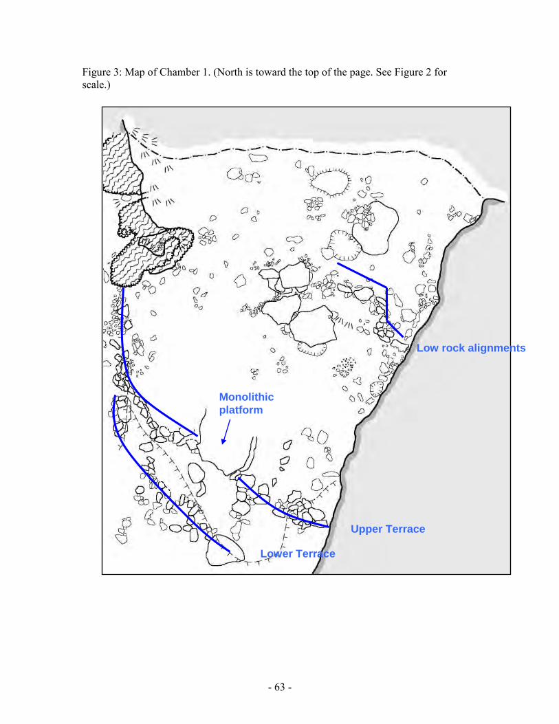
Chamber 1 Chamber 1, a .k.a. the Entrance Chamber, is mostly lit by natural sunlight, and
consists of a f airly flat, relatively spacious area with some low rock alignments in the eastern half of the chamber (Figure 3). Although we are still unsure of the function of these rock alignments in the Entrance Chamber, it appears that they may have directed entrance to and egress from the cave. At the southern end of the Entrance Chamber where it meets Chamber 2a are two terraces with a roughly square stone slab, approximately 2 m on a side, lying in the middle of the top terrace (Figure 4). Excavations showed an intact wall under this monolithic platform, which confirmed that the monolith was in its primary context.
We suggest two possible functions for this monolithic platform. F irst, it may have functioned as a platform for performances. The platform protrudes from the terrace retaining walls underneath, which accentuates the prominence of the platform within the architectural configuration. Ritual specialists or other persons may have stood atop the elevated platform area overlooking the lower level deeper in the cave. There may have been a l arger audience in the lower level or perhaps the ritual specialists addressed the gods who are thought to inhabit the inner recesses of caves. T he latter scenario is reminiscent of the platform structure on the edge of the Cenote of Sacrifice at Chichen Itza. The former suggests that the verticality construed by the architecture may reflect social distinctions manifest in spatial use. A lternatively, this monolithic platform may have functioned as an actual “altar,” where offerings were placed.
Chambers 4a and 4b Chamber 4 is a small space artificially separated from Chamber 2b by a dry-laid
rock wall (Figure 5). It is further partitioned by a low wall. Chamber 4b has a very low ceiling so one must crawl on all fours to maneuver, and though 4a is not much larger, one has enough room to sit up. From the northern end of Chamber 4a, one can slide on the stomach to squeeze into Passage 4 which leads to Chamber 5, a small chamber with many

- 55 -
cave formations. A rchitecture in this area appears to function to direct traffic, create smaller spaces, and inhibit access.
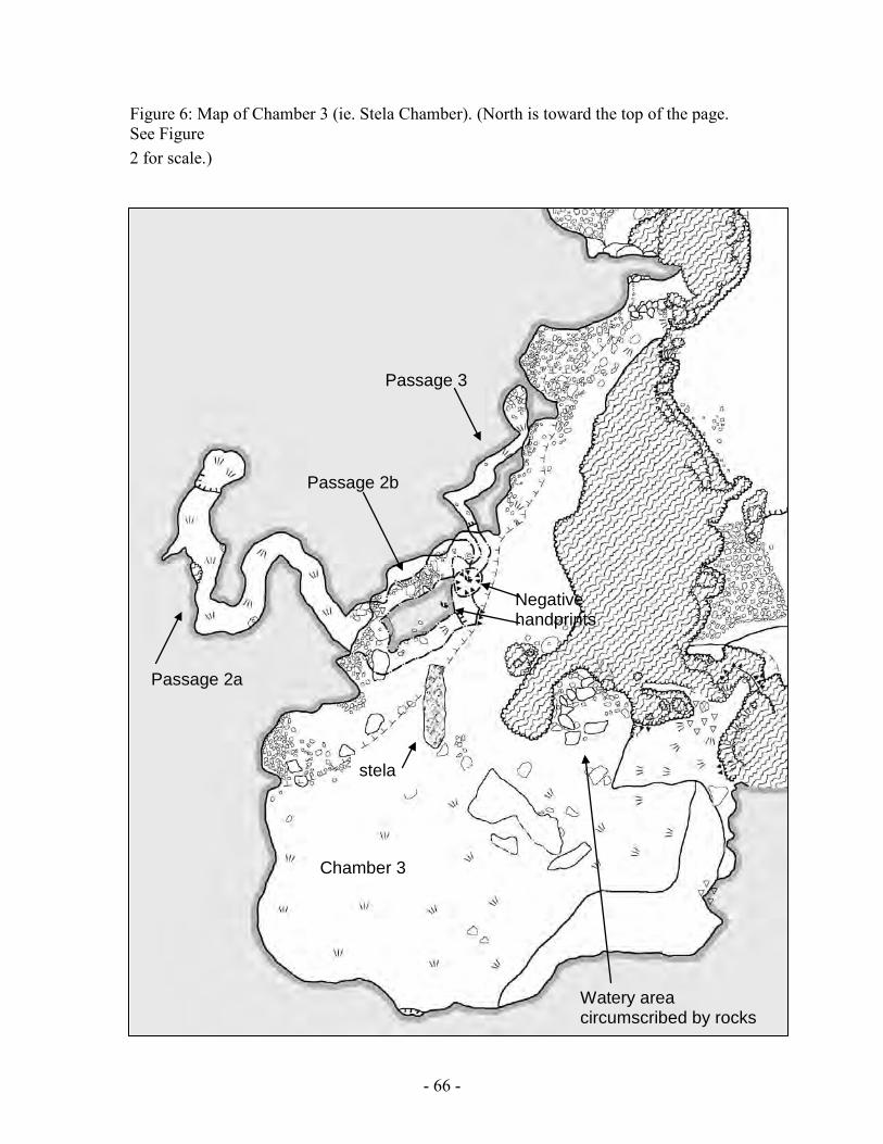
Chamber 3 (Stela Chamber) The Stela Chamber is arguably the most interesting space in Stela Cave (Figure
6). Two of the three access ways into the Stela Chamber are closed off with rock walls so that access was limited to a n arrow entranceway at the corner of Chamber 2a and 2b (which is the easiest access and probably most frequented) or otherwise through a small opening accessed via a short climb over flowstone. Interestingly, the easiest walkthrough entrance from Chamber 2b was closed off by the largest wall in the cave. Wall 7 is a dry-laid rock wall, approximately 1 m wide by 2 m high. T his suggests a deliberate regulating or redirecting of access into the Stela Chamber. There are numerous cave formations along the northeastern wall of Chamber 3, and some were observed to be broken with possible charring. A t the base of these speleothems large rocks are placed in a semi-circular manner and excavation revealed that these rocks were sitting on travertine (rimstone dam) formation (Figure 7). A large (approximately 4 m high, 2 m diameter) bulbous stalagmite bounds this area on t he northwestern side, and a line of stone extends southward. Excavation revealed less than 4 cm of deposition, which is very thin compared to other areas in this chamber. T his suggests that until recently (or even today, perhaps seasonally) this area was wet with water flow or flooding. The rocks were placed in a watery area, delineating an activity area within this chamber, made significant due to the presence of water. One of the more prominent features in this chamber is a 3-m long limestone slab (2.9 m long, 80 cm wide, 20 cm thick) lying on the floor (Figure 8). The shape clearly resembles a Maya stela, but inspection of both surfaces does not show any epigraphic or iconographic carvings. A n excavation unit at the northern end of the presumed “butt” end of this stone revealed a concentration of carbon and an ash lens along with faunal material (peccary?). We also recovered crystal manuports (cf. Brady and Prufer 2001) in this unit. Another intriguing archaeological feature of this cave is a pair of pictographs just northwest of this stela on the cave wall (Figure 9). These pictographs were painted by placing both hands against the wall and blowing soot onto it, in effect producing the shape of bird-like zoomorphs. No other prints of similar shape have been documented in Mesoamerican cave sites (cf. Bonor 1989; Stone 1995). These pictographs are located 1.4 m above the cave floor and 1 m apart from each other, and are placed so as to frame the entrance way to two upper passages.
As one climbs up into the upper passages, one finds a short and low crawlway that meets up w ith Passage 2. M idway in the passage, a mortar wall is constructed, whose function is puzzling. Was the function of this mortar wall to restrict access, light, and/or sound? O r perhaps to close off or enclose spirits, as a way to control the supernatural powers in the cave? Why the extra effort to put up a mortar wall and not simply a dry-laid rock wall like the other walls, particularly in such an already low and small space? A t the juncture of Passages 2a and 2b, stalactites were broken and the breakage scars were heavily charred. A stack of ceramic sherds were found in the northern end of this crawl way. T he northern end may have served as an altar, before venturing in further into Passage 2. T he significance of this area is heightened by its

- 56 -
location as a “cross-road” or passage juncture, which is commonly a ritually significant and eventful space (Stone 1997). Speleothem breakage is encountered toward the end of Passage 2a, which appears to be smoke-blackened. SPATIAL ORGANIZATION IN CAVES
Ethnography-based spatial models may aid in understanding the spatial logic in cave settings. O ne ubiquitous model found in varying scales is the microcosm based concepts of directionality. In this model, horizontal spaces are defined by four world corners and a center point, and may be observed in altar tables, caches or offerings, houses, milpas, and villages (Vogt 1976:58). Given that this spatial delineation based on a cosmic template is found at varying scales, it is plausible that cave spaces were organized using this model as well (cf. Ishihara 2000; Moyes 2001).
Likewise, a center-periphery model may be applicable (Brown 2004; Gillespie and Joyce 1998; Gossen 1974; Hanks 1990; Taube 2003). The center is represented by the house, community, and ruler, and is associated with concepts such as stability, safety, and order. On the other hand, the periphery relates to the forest, wilderness, and the supernatural, along with themes of chaos, danger, and the primordial past. Within a cave context, the cave entrance might serve as the relative “center” while the deeper recesses of the cave represented “peripheral” spaces that were closer to the supernatural powers of the earth deities (cf. Stone 2004).
Another basic conceptual framework may also assist in our understanding: the hot-cold system of classification. The hot-cold binary opposition may be manifest in a variety of meanings but the most relevant one for this paper is the high-low opposition (Stone 1997, 2004). According to this hot-cold system, “high” correlates with “hot” and refers to mountains, heat, sun, power, masculinity, strength whereas “low” corresponds to “cold” referring to caves, wet, dark, moon, weak, and femininity (Stone 2004). High also connotes order and is inherently good, while low implies chaos, ambiguity, and evil (Stone 2004). Though Stone examines this high-low in terms of artifact distribution, we suggest that it may be applied to spatial constructions to understand the spaces created as an artifact of ritual activities. IMPLICATIONS In general, architecture in caves aids us in identifying ritual activity areas. More specifically, the architecture in Stela Cave clearly functioned to delineate certain spaces for presumably varied purposes. For example, the architectural modifications in each of the areas created a variety of spaces. In Chamber 1, the two terraces not only define horizontal space in the relatively open area but also accentuate vertical space. Chambers 4 a and b are enclosed spaces with naturally low ceilings, and lead to a small chamber via a low passage, creating a bottleneck effect. E ntrance into the spacious and dome-like Chamber 3 i s restricted, probably because of the primary importance of the Stela Chamber. A mortar wall was built in the short and already narrow Passage 2b. The stone monument and the burning of some animal are likely associated with the upper passages visually marked by the two zoomorphic pictographs.
In Stela Cave, architecture was constructed to create sacred spaces which were characterized by increased remoteness, enclosure, smallness, complete darkness, and

- 57 -
presence of water and speleothems. Such areas may have signified the “peripheral” and supernaturally powerful spaces, and traversing these spaces may have been analogous to traveling into the depths of the earth to converse with the gods. Additionally, architecture may have served to delimit spaces to show where access changed or became more restricted. Although the functions of the constructed spaces are hard to pinpoint, the extensive architectural modifications in Stela Cave prompt us to look at the socio-political implications of the construction of particular spaces within an already regulated place. The social context of modern cave use reveals that it is usually ritual specialists who conduct rituals and enter the cave. This suggests that, in the prehispanic periods, access to such sacred spaces such as caves would have been similarly if not more restricted than today, because the Classic period Maya polities presumably had a more rigid social and political hierarchy than modern-day Maya communities. T hus construction of architecture within the cave may have been a way to accentuate the limited access, blocking off particular chambers, further narrowing already tight passageways, and creating small and difficult-to-reach spaces. Moreover, the labor invested in such construction projects indicates the importance of architectural modifications to the rituals and their practitioners. T he terrace retaining walls that support the monolithic platform are comprised of large (50 -75 cm) boulders, which would imply access to and control over labor, whether it was a community project or a project of more coercive nature. CONCLUSIONS In sum, by looking at the cave context as a variegated landscape manipulated and tailored according to Maya spatial logic, we are able to grapple with the dynamic and complex nature of cave rituals. Caves were not homogeneous spaces that simply served as passive backdrops for ritual activities. Rather they were modified and organized in such a way that they represented an ordered space. Natural morphological features as well as architectural modifications were used to construct and define spaces that were appropriate for each activity or segment of the ritual procession.

- 58 -
References Cited: Barrera Vasquez, A. 1970 The Ceremony of Tsikul T'an Ti' Yuntsiloob at Balankanche. In Appendix
to: Balankanche, Throne of the Tiger Priest, edited by E. W. I. Andrews, pp. 72-78. MARI Publication 32, New Orleans.
Bonor Villarejo, J. L. 1997 Current Problems at Mesoamerica Caves Investigations: Underground
Archaeology and Surface Archaeologist. Paper submmited to the 62nd Annual Meeting of the Society for American Archaeology, Nashville, USA.
Brady, J. E. 1989 An Investigation of Maya Ritual Cave Use with Special Reference to Naj
Tunich, Peten, Guatemala. Ph.D. dissertation, University of California, Los Angeles.
1997 Settlement Configuration and Cosmology: The Role of Caves at Dos Pilas. American Anthropologist 99(3):602-618. Brady, J. E. and K. M. Prufer 2001 Caves and Crystalmancy: Evidence for the Use of Crystals in Ancient
Maya Religion. Journal of Anthropological Research 55:129-144. Brady, J. E., A. Scott, A. Cobb, I. Rhodas, J. Fogarty and M. Urquizu Sanchez 1997 Glimpses of the Dark Side of the Petexbatun Project. Ancient
Mesoamerica 8:353-364. Brady, J. E. and G. Veni 1992 Man-made and Pseudo-karst Caves: The Implications of Subsurface
Features within Maya Centers. Geoarchaeology 7(2):149-167. Brown, L. A. 2004 Dangerous Places and Wild Spaces: Creating Meaning with Materials and
Space at Contemporary Maya Shrines on E l Duende Mountain. Journal of Archaeological Method and Theory 11(1):31-58.
Gillespie, S. D. and R. A. Joyce 1998 Deity Relationships in Mesoamerican Cosmologies. Ancient Mesoamerica
9:279-296.

- 59 -
Gossen, G. H. 1974 Chamulas in the World of the Sun. Harvard University Press, Cambridge. Hanks, W. F. 1990 Referential Practice: Language and Lived Space Among the Maya.
University of Chicago Press, Chicago. Heyden, D. 1975 An Interpretation of the Cave Underneath the Pyramid of the Sun in
Teotihuacan, Mexico. American Antiquity 40:131-147. Ishihara, R. 2000 Ceramics from the Darkness: An Investigation of the Cave Ceramics from
Actun Chechem Ha, Belize. B.A. thesis, University of Tsukuba. La Farge, O. 1947 Santa Eulalia: the religion of a Cuchumatan Indian town. University of
Chicago Press, Chicago. Moyes, H. 2001 The Cave as a Cosmogram: The Use of GIS in an Intrasite Spatial
Analysis of the Main Chamber of Actun Tunichil Muknal, a Ceremonial Cave in Western Belize. Masters thesis, Florida Atlantic University.
Sandstrom, A. R. 2004 The Cave-Pyramid Complex among Contemporary Nahuas of Northern
Veracruz. In In the Maw of the Earth Monster: Studies of Mesoamerican Ritual Cave Use, edited by J. E. Brady and K. M. Prufer, pp. i n press. University of Texas Press, Austin.
Sanmiguel, I. 1994 A Ceremony in the 'Cave of Idolatry': An Eighteenth-Century Document
from the Diocesan Historic Archive, Chiapas, Mexico. In Sacred Sites, Sacred Places, edited by D. L. Carmichael, J. Hubert, B. Reeves and A. Schanche, pp. 163-171. Translated by A. Ben. Routledge, London.
Stone, A. 1997 Ethnographic Spatial Models and Artifact Distribution in Maya Caves. In
A paper presented at the 62nd Annual Meeting of the Society for American Archaeology, Nashville, April 1997.

- 60 -
2004 A Cognitive Approach to Artifact Distribution in Caves of the Maya Area. In In the Maw of the Earth Monster: Studies of Mesoamerican Ritual Cave Use, edited by K. M. Prufer and J. E. Brady, pp. in press. University of Texas Press, Austin.
Taube, K. A. 2003 Ancient and Contemporary Maya Conceptions About Field and Forest. In
The Lowland Maya Area: Three Millennia at the Human-Wildland Interface, edited by A. Gomez-Pompa, M. Allen, S. Fedick and J. Jimenez-Osornio, pp. 461-492. Haworth Press, New York.
Turner, P. R. 1972 The Highland Chontal. Holt, Reinhart, and Winston, New York. Uke, T. 1970 Cutting the Hour. Westways 62(5):30-33,57. Vogt, E. Z. 1976 Tortillas for the Gods: A Symbolic Analysis of Zanacanteco Rituals. 1993
ed. University of Oklahoma Press, Norman.

- 61 -
Figure 1: Belize River Valley showing location of Stela Cave

- 62 -
Figure 2: Map of Stela Cave.
- 63 -
Figure 3: Map of Chamber 1. (North is toward the top of the page. See Figure 2 for scale.)
Monolithic platform
Upper Terrace
Lower Terrace
Low rock alignments

- 64 -
Figure 4: Photos of Monolithic Platform (View from the southwest of Upper terrace and Monolithic platform).
N
Monolithic platform
Upper terrace

- 65 -
Figure 5: Map of Chambers 4a and 4b. Blue lines show dry-laid rock walls; red arrows indicate access way. Dotted arrow shows access way but probably created due to modern looting activities. (North is toward the top of the page. See Figure 2 for scale.)
Chamber 4a
Chamber 4b
Chamber 4a
- 66 -
Figure 6: Map of Chamber 3 (ie. Stela Chamber). (North is toward the top of the page. See Figure 2 for scale.)
stela
Watery area circumscribed by rocks
Passage 2a
Chamber 3
Passage 3
Passage 2b
Negative handprints

- 67 -
Figure 7: Area in Chamber 3 circumscribed by a semi-circular arrangement of rocks directly atop rimstone dam formation.

- 68 -
Figure 8: Plain stela in Chamber 3.

- 69 -
Figure 9: Negative handprints in the form of bird-like zoomorphs. These are on either side of the entrance way to the upper passages, in effect framing the entrance way.

- 70 -
Changes and Continuities in Ritual Practice at Chechem Ha Cave, Belize: Report on Excavations Conducted in the 2003 Field Season
Holley Moyes
Introduction The Western Belize Regional Cave Project (WBRCP) under the direction of Dr.
Jaime Awe has conducted investigations since 1997 in Chechem Ha, an ancient Maya ritual cave site. Cave research programs have traditionally emphasized the meaning of caves and their contents rather than the ritual behavior that occurred within them. Some researchers have tried to define the types of rituals that may have taken place within caves (Awe 1998; Brady 1989; Helmke & Awe 1998, 2001; Moorehart 2002a, 2002b; Pohl 1981; Pohl & Pohl 1983, Reents-Budet & MacLeod 1997; Stone 1995), but despite years of research, little is known about ritual practice or its continuity and change over time. One of the reasons for this is that that chronology in caves is difficult to establish. Major artifacts and features are often surface deposits that become co-mingled. Although ceramic chronologies can provide estimates of when a cave was utilized, the palimpsest nature of these deposits interferes with the determination of absolute dates from preserved or charred organic remains. In some cases the investigation of sub-surface deposits and radiocarbon dating may help sort out chronologies, but unlike surface sites, the enclosed cave environment often prevents a thick sediment buildup. The deep sub-floor deposits in Chechem Ha Cave are exceptional and provide a rare opportunity to evaluate sealed deposits in a cave context. The 2003 excavations in Chamber 2, funded by FAMSI, were initiated to examine changes in ritual practice in the chamber during the course of its use from the early part of the Middle Preclassic through the Early Classic periods. Setting
Chechem Ha is a complex cave system located in western Belize (Figure1). It is an un-looted ancient Maya ritual site discovered in 1989, a nd may be one of the most remarkable finds in Maya cave archaeology. Although the cave was opened for tourism long before archaeological investigations commenced conscientious curation by the owners has preserved much of the data and the cave still offers a fruitful venue for the study of ancient ritual practice.
The cave is not directly associated with any settlement centers. It is located in a peripheral area between two mid-sized Maya sites, Las Ruinas to the north and Minanhá to the south. Las Ruinas dates from the Late Middle Preclassic (600-300BC) to the Post Classic period (900-1225AD) (Taschek and Ball 1999). M inanhá dates from the Late Preclassic (300-100BC) until the Late Classic period (Iannone 2001). Both sites report termination events. B ased on a radiocarbon date, Structure 30 a t Las Ruinas was terminated between 850-950 AD, and at Minanhá, a royal residential group was terminated at roughly 800 A.D. based on ceramic chronology.

- 71 -
Chechem Ha sits on a steep hillside above the Macal River 370m above sea level. It is composed of hard compact limestone. The tunnel system is 198m in length and consists of over 300m of tunnels (Figure 2). The cave is classified as "dry" because there is no interior water source (Awe et al. 1997). Drip formations (speleothems) are present in only two areas: Chamber 1, just inside the entrance, and in Chamber 2 deep within the tunnel system. Intermittent pools of water form beneath these formations during rainstorms and drain shortly afterward. W ater may enter the tunnel system from Chamber 1 du ring very heavy storms. A natural water channel has been cut along the edge of the tunnel and terminates in a natural drainage in the center of Chamber 2. A great deal of ancient speleothem breakage and removal was noted throughout the cave system. In fact, the only remaining stalactites are in Chambers 1 a nd 2, and the only stalagmites are located beneath the drip formation in Chamber 2 and are quite small (<16cm). The largest of these was harvested for purposes of study and dated using AMS. The calibrated two-sigma date indicates that the speleothem began to grow 881-903 AD. (Henry Schwarcz 2003 personal communication).
Evidence of ritual activity is present in a number of discrete activity loci located throughout the tunnel system. Artifact deposits are located along the walls in niches and alcoves, and on eleven ledges ranging from 3-7m. above the tunnel floor. Additionally, artifacts are found in six elevated side passages. Four of these passages are narrow with low ceiling heights and designated as "crawls." Artifact assemblages in various loci are distinct from one another suggesting specialty usage. For example, Elevated Passage 1 (EP1) contains a cache of large vessels measuring up to one meter in diameter. Tunnel 2 features a series of vessels with inverted bowls covering their bottoms resembling mushrooms, and Ledge 4 contains four stone circle constructions. Of particular interest is the large cathedral-like chamber at the cave's western terminus designated the "Stela Chamber" due to the presence of a miniature uncarved stela surrounded by a circle of stones (Figure 3, Awe et al. 1997).
The site also contains undisturbed sub-floor deposits and deep stratigraphy. Throughout most of the tunnel system the surface of the floor is composed of a hard packed dark clay. S ub-surface cultural deposits range from 6cm-1.5m deep. T est excavations conducted in 2002 demonstrated that the deepest deposits with the clearest stratigraphy were present in Chamber 2.
Chamber 2 i s located near the center of the tunnel system, 100m from the cave entrance at a fork in the tunnel system (See Figure 2). The best pathway to the deeper cave passages follows the Main Tunnel, which leads through this area. The chamber is roughly rectangular in shape, measures 3m x 8m, and is oriented on a SE axis (Figure 4). There is a large outcrop of limestone along the northwest wall. As one moves through the cave, the room is entered at the southeast corner and the exited at the northeast corner so that the natural pathway forms a U-shape around the stone outcrop.
An alcove containing potsherd scatters on the modern surface juts out from the southwest corner. Another alcove juts off from the northwest corner and leads to a crawl space that continues into deeper passages. The alcove slopes up toward the crawl at on a 10˚ slope and is muddy and slick throughout the year. This route is much more difficult to traverse than the passage that continues via the northeast corner and artifact densities in the crawl space suggest that it was rarely used. The wet conditions are caused by the large stalactite chandelier, an active drip formation hanging over the entrance to the

- 72 -
alcove (Figure 5). Large clusters of stalactites are referred to as chandeliers by cavers because their shape bears a resemblance to elaborate light fixtures. Beneath the stalactite is an intermittent pool that fills with water during rainstorms. The water has excavated the mud well below the floor level of the chamber. A large scatter of potsherds can be seen in the muddy matrix beneath the stalactite. In the center of the chamber on t he modern surface, a large broken stalactite sat on top of a roughly circular pit measuring 70cm across. Intermittent pools caused by drips from the ceiling form in the pit during heavy rains. Additionally, we witnessed a low energy stream running into the chamber from the cave entrance along the walls of the tunnel system draining into this low area during heavy storms. Adjacent to the pool along the west wall is a pile of large speleothems approximately 50cm in diameter and 50cm high. It was unclear if this was an ancient Maya deposit, but the owners of the cave denied having placed the pile in its current position.
Two ledges are located above the chamber. Ledge 9 is a small area, 2 x 2m, located at the west end of the chamber sits 6m above the chamber floor. It is a small shelf that based on t he ceramic chronology, was only sparsely utilized during the Late Classic period. Ledge 10 sits 7m above the west wall of the chamber (Figure 6). The ledge measures 6 x 2.5m and a small niche in the back wall of the ledge is covered with soda straws. T hese are precipitates of calcium carbonate that are the initial stages of stalactite growth and whose name derives from their resemblance to drinking straws. There is a great deal of bat guano on this ledge and it is a modern bat roost. The ledge was heavily utilized by the ancient Maya, and almost one third of all the artifacts in the cave were found in this location. C eramics on the ledge may date as early as the Preclassic period (Jim Aimers 2004 personal communication) but most are diagnostic of the Early Classic (Ishihara 2001). T wo AMS radiocarbon dates from pine charcoal collected from in between stacks of potsherds confirm that the ledge was utilized from as early as 1000BC to 420AD (Oxcal3 2760±34rcybp calibrates with a two-sigma range to 1000-820 BC 1714±33 and rcybp calibrates with a two-sigma range to AD 240-420). This suggests that Ledge 10 was an important ritual locus from a very early point in the utilization of the cave. Methods
In this study, charcoal flecks recorded in excavation contexts are used as a proxy for both intensity of use and as an indicator of activity areas. Since the dark zone of the cave begins approximately 33m. inside of the tunnel system, all tunnel branches and activity loci beyond this point were necessarily negotiated using artificial light. Evidence that the Maya used wood torches to light their way in caves is abundant (Morehart 2002a) and ceramic torch-holders have been found in caves (Brady 1989; Graham et al. 1980; Reents-Budet 1980). In his study of plant remains in Chechem Ha, Christopher Morehart (2002a) reported that all charcoal flecks collected from surface deposits were of the Pinus species. T his agrees with ethnographic data collected in the 2003 field season, which indicates that local pine is used today in the construction of torches to save money on fuel costs. Pine is easily available in the area and stands of trees are located near the cave.
Chamber 2 is located well within the dark zone meaning that all activity must be illuminated by some artificial source. Therefore we can reasonably assume that unless

- 73 -
otherwise indicated, the charcoal deposits at Chechem Ha were produced by torches used as sources of light. There are only two basic classes of activities that one can envision taking place within the chamber. Individuals are either passing through on their way to one of the deeper areas or they are pausing within the chamber to engage in some kind of ritual activity. Passing through Chamber 2 on the way to some other location within the cave should produce a rain of charcoal in the U-shape of the pathway. Pausing to engage in prolonged ritual activities should generate localized densities of charcoal adjacent to the location of torch bearers.
We chose Chamber 2 to conduct a broad horizontal excavation because to reach any of the deeper sections of the cave one would necessarily pass though it and additionally, test units conducted in 2003 i ndicated that the area had deep subsurface deposits. The excavation extended from the south wall to the north wall of the chamber and measured 2m x 8m. (Figure 7) T he test unit excavated in 2002 w as re-opened to provide a guideline for recognizing level (Figure 8). A total of 18 levels were recorded. There were no pr epared floors in this cave, so use surfaces were determined during excavation by 1) observing changes in coloration and texture in the sediment matrix, 2) noting the presence of horizontally embedded ceramic sherds or other artifacts within the matrix, which suggested trampling, and 3) noting charcoal flecks embedded within the matrix.
Photomapping was used to record surfaces. This recording technique is an infield GIS based data collection strategy tailored to the documentation of small artifact distributions (Aldenderfer in press; Aldenderfer and Craig 2002; Craig 2000; Craig and Aldenderfer in press; Craig et al. 2003). T he excavation is divided into 1m units. A digital image was taken of each unit within the level. These were stitched together and georeferenced in ArcView 3.2. The final product recreates the continuous surface of the excavation so that the entire level may be viewed and analyzed as a single entity. Artifact distributions were recorded directly into the GIS during excavation. A ll artifacts including charcoal flecks were represented as a distribution of points. T he geomorphology of the cave and cultural features were represented by lines and polygons.
The advantage of this system is that 1) the accuracy of the GIS database can be checked on the spot because it is created infield, 2) an entire excavation layer can be viewed on a single screen, 3) a photographic record and georeferencing are conducted simultaneously, and 4) small finds such as carbon flecks can be rapidly piece plotted in situ. Excavation profiles were also made using the photomapping technique. Presented here is the georeferenced north wall profile (Figure 9). Excavation levels are illustrated in the photograph. Eight classes of artifacts were found in the excavation listed in order of quantity 1) charcoal flecks, 2) ceramic sherds, 3) speleothems (stalactites, stalagmites, spalls, and soda straws), 4) limestone rock, 5) jute shell (Pachychilus indiorum), 6) ethnobotanic remains, 7) animal remains, and 8) an obsidian blade. Matrix samples from Units B7 and C7 were transported to the camp for infield flotation. Charcoal from the flotation was weighed in order to estimate the increase or decrease of the chamber's usage between layers.
Levels were dated using pine charcoal. A sample from each layer was sent to the AMS dating facility at the University of Arizona. Results were calibrated using Oxcal 3

- 74 -
and reported at the two-sigma range. To aid in evaluating site formation processes, a combination of micromorphology
and geochemical analyses are also underway. A column sample from the north wall profile was collected in the 2003 f ield season. The sample was resin impregnated and thin sections were produced. Bulk samples from each excavation layer were also collected for elemental analyses. Excavation Although more than one matrix type is present in each level, laboratory analysis indicated that, with the exception of Level 7, the primary texture characterization throughout the excavation was clay. S everal observations suggested that 2:1 clays (shrink/swell) were present in the matrix: 1) we noted crack patterns on the surfaces of many areas, 2) the sediment was very sticky, and 3) samples brought from the field shrank considerably when dried. Preliminary XRD analysis indicates that the sediment contains mixed clays which include 2:1 varieties as well as kaolinites. Besides the heavy clays, the entire deposit contains bat guano or other excretory organics in a varying percentage within each layer as well as differing amounts of limestone marl.
Below is a brief description of each level that includes the most interesting findings in each. Diagnostic ceramics are pictured in Appendix A. The excavation data is compiled in Table 1. Although there is overlap at the two-sigma range some of the AMS dates at both the top levels and the bottom levels (See Figure 17), the stratigraphy of the excavation was clear and layers do not appear to be mixed to any significant degree (See Figure 9). Table 1. Summary of excavation data by level.
Level AMS Date Period Color pH Excavated Surface Flotation Ceramic Speleo- Spe
Area m² Charcoal Charcoal
(gr.) Sherds thems Fi
1 Not Available 10yr 4/1 7.6 12.774 265 0.8 108 7
2 240-440AD
Early Classic 10yr 4/1 7.6 12.613 770 4.72 241 16 jute
3 400-560AD
Early Classic 10yr 3/2 7.5 12.47 2155 1.97 165 16 jute
4 250-440AD
Early Classic 10yr 3/2 7.5 12.756 1779 4.62 112 7
5 240-440AD
Early Classic 10yr 2/1 7.6 12.295 3341 5.49 210 21
jute anim bone
6 130-420AD
Proto-Early Classic 10yr 4/2 7.4 12.581 8244 21.98 462 29
obsid blade

- 75 -
7 350-40BC
Late Preclassic 10yr 5/3 7.7 12.576 815 7.03 10 3
8 1130-890BC
Middle Preclassic 10yr 3/2 7.5 10.056 1290 1.57 13 28
stone circle
9 1000-820BC
Middle Preclassic 10yr 3/1 7.6 10.019 2884 2.02 6 6 corn
10 1000-820BC
Middle Preclassic 10yr 2/1 7.6 9.9653 3537 6.59 4 1
11 1130-930BC
Middle Preclassic 10yr 2/1 7.8 9.4727 1390 1.85 0 2
12 1050-830BC
Middle Preclassic 10yr 2/2 7.8 9.2701 1591 1.98 0 1
2spal w/res
13 1320-910BC
Middle Preclassic 10yr 4/2 7.6 10.249 917 4.87 0 7
14 Not Available ? 10yr 3/2 8.0 5.5446 172 4.16 0 9 spall
15 Not Available ? 10yr 5/3 8.0 3.2491 20 1.02 0 34
16 Not Available ? 10yr 5/2 7.9 3.7373 12 0.01 0 67
17 Not Available ? 10yr 5/2 7.9 2.0 5 trace 0 42
18 Bedrock 1 1 6 Level 1 was the modern use surface. The matrix consisted of heavy plastic dark gray clay mixed with poorly sorted white limestone marl. The layer ranged in thickness from 2-4cm. The surface had been regularly trampled by tourists wearing boots with thick treads or sneakers which caused the matrix to compact to a consistency resembling modeling clay. In the center of the chamber in the area we noted above as a natural drain was an oval shaped pit measuring 60 x 80cm designated Feature 1. The matrix within the pit was wetter than that of the rest of the level and this continued throughout every level to bedrock. On top of the pit sat a stalactite fragment measuring 55 x 72cm.
The plastic matrix of the layer literally peeled away revealing the shiny smooth surface of Level 2 below (Figure 10). On the modern surface 265 charcoal flecks were recorded. Within the unit matrix there were 108 ceramic sherds and seven small soda straws. Data recovered from the flotation of Unit B7 is likely to be underestimated due to the heavy clay matrix and problems with deflocculating this sample. This level is probably of limited analytical value because of the impact of modern usage.
Level 2 dated to the Early Classic Period. The surface of this layer was unusual because the texture was smooth and shiny. The color was dark gray similar to Level 1, was mixed with 1% marl, and was 1-2cm in thickness. A lthough the matrix was

- 76 -
primarily clay, thin lenses of sand and silt were present in the northwest area of the excavation. T hese thin strata can be seen in the north wall profile (See Figure 9). Preliminary analysis of the unit's micromorphology suggests that these deposits were water-laid. On the Level 2 surface there were 770 charcoal flecks. The layer contained 241 ceramic sherds, a single spire-lopped jute shell, and 16 s peleothems all of which were small soda straws. Level 3 dated to the Early Classic Period. It consisted of a clay or clay-like matrix of medium compaction containing 1% fine marl. T he color was dark grayish brown and the level was 1-2cm thick. Thin lenses of water laid silt and sand were also present in this level particularly in the center and the northwest areas of the excavation. There were 2179 c harcoal flecks recorded on the surface of the level. T he matrix contained 165 ceramic sherds, 16 small speleothems, and a single spire-lopped jute shell. Two features were present and both were located in the northwestern part of the excavation. In this area, the cave wall slopes inward and there was little sediment covering the bedrock. Ceramic sherds were deposited on t he bedrock in two small natural depressions measuring 8-10cm in diameter (Figure 11, Feature 3). This type of feature has also been noted in surface deposits throughout the cave. Level 4 dated to the Early Classic Period. T he level was 2-6cm thick and the matrix color and texture was similar to Levels 2 and 3 but there was no visible evidence of thin water laid lenses. Clay cracking was noted in this level. Patches of brown silt (7.5yr5/6) are present in the central part of the excavation and between cracks. T here were 1779 charcoal flecks on the surface of the level and the matrix contained 112 ceramic sherds and 7 speleothems. Of these 25 sherds and a speleothem were located in Feature 1. Level 5 was the lowest level that dated to the Early Classic Period. The matrix was dark brown to black in color with medium compaction. Although the sediment was somewhat similar to Levels 1-4, there was slightly more marl (2%) within the 2-6cm thick level. Heavy cracking of the surface was noted in this layer. On the surface, we recorded 3341 charcoal flecks. Within the matrix 210 ceramic sherds and 21 speleothems were excavated. Thirty-nine of the sherds were found in Feature 1, which continued to this level.
There was a great deal of activity on this level, particularly along the western boundary adjacent to the cave wall. Feature 4 was a concentration of 16 ceramic sherds, a spire-lopped jute shell, and an animal bone fragment. There was burning a good deal of charcoal associated with this deposit. S ome of the wood was only partially charred. Adjacent to the wall and 30cm north of Feature 4 was Feature 5. T his was a concentration of 74 ceramic sherds, a spire-lopped jute shell, and a great deal of carbonized wood. Interestingly, both of these deposits were located directly below sherd concentrations found on the modern surface Level 6 dated to the Proto-Early Classic Period. The sediment in this layer was clay or clay-like, dark grayish brown in color, and mixed with 20% marl. O range to brown (7.5yr4/4) patches of silt were also present throughout the level. A lthough the level was only 1-3cm thick, the amount of charcoal from the intra layer flotation was much higher than in other layers (21.98gr). The matrix also contained 462 c eramic sherds and 29 speleothems. Additionally, the numbers of charcoal flecks on the surface
- 77 -
of the level were the highest recorded in the excavation (8357). A stalagmite was encountered on this level. Although speleothems were found on all levels, this was the first time that we encountered a stalagmite in the excavation. Features 4 and 5 both originated on this level and were used continuously through Level 4. An obsidian blade fragment was found under a cobble at the base of Feature 5. Level 7 dated to the Late Preclassic Period. The sediment on this level was less compacted as compared with others, the color was light brown to yellowish brown, was 1-2cm thick, and contained 4% marl. An XRD analysis of this deposit demonstrated that, although the deposit had the texture of clay loam, it is almost entirely organic. The high phosphate (16.13%) and elevated copper content (300 ppm) of this level further suggested that it was composed primarily of bat guano. On the surface there were 836 charcoal flecks and from the matrix only 10 ceramic sherds and 3 speleothems were recovered. Level 8 dated to the Middle Preclassic Period. T he sediment was very dark grayish brown, medium compaction, 1-3cm thick, and was mixed with 2% marl. Crack patterns were present throughout the matrix. On the surface of the level there were 1304 charcoal flecks and in the matrix there were 13 ceramic sherds and 28 speleothems. The speleothems within this level were larger than in levels 1-7. A circle of 14 cobble-sized limestone rocks and one speleothem was found adjacent to the east wall of the cave. This feature was located directly below Feature 4 on Level 5. Level 9 dated to the Middle Preclassic Period. The matrix was very dark gray, contained little marl, was 2-4cm thick, and exhibited medium to heavy compaction. Patches of different dark yellowish brown matrix mixed with poorly sorted sand were also found on this level. On the surface of the level 2919 charcoal flecks were recorded and there were 6 ceramic sherds and 6 speleothems collected from the matrix. Two well-preserved corn kernels were recovered from flotation. Level 10 dated to the Middle Preclassic Period. The matrix was dark brown to black in color, 2-3cm thick, and contained little marl. T here were numerous crack patterns in this layer and lighter colored sediment filled the cracks. On the surface of this level were 3537 charcoal flecks and in the matrix, 4 ceramic sherds and 1 speleothem. This was stratigraphically the lowest level in the excavation that contained ceramic sherds. Level 11 dated to the Middle Preclassic Period. The matrix was very similar to that of Level 10 but was mixed with slightly more marl. It was 2-4cm thick. There were 1390 charcoal flecks present on the surface and 2 speleothems found in the matrix. Level 12 dated to the Middle Preclassic Period. The 5-7cm thick sediment was very dark brown and exhibited medium compaction. There were 1591 charcoal flecks on the surface and one speleothem in the matrix. In the 2002 t est excavation, two bowl-shaped speleothem spalls were found sitting in an upright position on the surface (Figure 12). Both contained a black sticky residue. The first spall (a) was round and measured 6cm in diameter and 3cm in height. The second (b) was triangular in shape measuring 5 x 4cm and 2.5cm in height. Level 13 dated to the Middle Preclassic Period. T he sediment had a high concentration of marl (22%) and the color was dark grayish brown. This layer was 6-10cm thick and a water channel ran through it. The channel originated in the east side of

- 78 -
the excavation and continued to the north wall. Seven speleothems were recorded in this level and all were located in the channel. There were 917 charcoal flecks located on the surface. Dates are note yet available for Levels 14-17. As we began approaching bedrock, the sampled are became progressively smaller. This is noted in Table 1. The sediment from Level 14 was very dark grayish brown containing 11% marl and was 8-10cm thick. Crack patterns were distinct on this level. Nine small speleothems and soda straws and a spall were found in the channel. The spall resembled those found in Level 12 but did not contain residue. There were 172 flecks of charcoal recorded on the surface. Level 15, 16, 17, and 18 were composed of a similar matrix. The color of the sediment was brown to grayish brown, contained almost 40% marl, and was very wet throughout. In the field, it appeared to have a greenish gray cast. The marl was friable and some of the pebbles were colored green. Cobble-sized mudstone was also present. Layer 15 is located at the same level as the intermittent pool beneath the stalactite chandelier below surface of the tunnel floor. T his suggests that it may have collected water from seepage beneath the floor when the pool filled during rainstorms. This could account for the very wet conditions of the basal layers of the excavation. Although it was unclear as to whether these levels were cultural, charcoal was present throughout the matrix of Level 15, small flecks were present in Level 16 and a few flecks were found in Level 17. A dditionally, all levels contained numerous large speleothems. Some are visible in the north wall profile (See Figure 9). Thirty four speleothems were collected in Level 15, 67 i n Level 16 (Figure 13), and 42 in Level 17. T hey were not spread throughout the excavation but were found in clusters. In Levels 16, 17, and 18 t he clusters were directly on top of one another suggesting that they were stacked. Many of the speleothems were large stalagmites. Although stalactites could conceivably fall from the ceiling, it is highly unlikely that stalagmites could have arrived at their current position without assistance. Additionally, the placement of the speleothems within the excavation is reminiscent of the speleothem pile located on the modern surface. Bedrock was reached at Level 18. S ix speleothems including three stalagmites and a spall were collected on this level. There was one small piece of charcoal which was too small for dating. Preliminary Analyses
To evaluate the variation in the use of space within the chamber, charcoal distributions will be analyzed and compared using the point data recorded in the field for each level. The goal of the analysis is to find areas that have distributions of charcoal that are denser than one would expect. Levels 6 a nd 7 are used to demonstrate the method and present preliminary findings. These two levels were selected because they were dissimilar. O n the surface of Level 6 there are 10 times as many fragments of carbon and in the matrix 31 times as many ceramic sherds as there are on Level 7. These differences are striking and indicate a major change in the intensity of activity between these two adjacent levels that can be described numerically.
The analysis was carried out using GIS (Craig et al. 2004). Traditional clustering algorithms are inappropriate for the analysis since the goal was to locate and examine unexpected densities not clusters. A new method using observed and expected density maps was employed to produce Density Difference maps. These were created by

- 79 -
subtracting the expected densities from the observed densities. To create the density map of the observed data, nearest feature distances were calculated to determine the minimum distance between two points using the ArcView 3.3. This value was used as the search radius in calculating density to avoid producing densities composed of single objects. The resulting raster is the Observed Density Count.
To generate an expected density, the Animal Movements extension was used to produce a random distribution of points that have the same number of elements as the observed set. Nearest Neighbor was calculated for this set to determine whether the set was clustered or not. If the set was clustered, another set was created and tested until a set of unclustered points was generated. T he density of the observed point array was used to generate the Observed Density Count following the procedures described above.
To create the Density Difference field, the Raster Calculator was used to subtract the Expected Density Count from the Observed Density Count. T he resulting raster illustrates areas where there are relatively more or fewer objects than would be expected in a random unaggregated distribution. T he maps are displayed using the standard deviation stretch with a two color ramped palette (Figure 14, Figure 15).
The similarities and differences between these two levels help to both expand and constrain aspects of interpretation of the use of Chamber 2. T he following observations can be drawn from this preliminary analysis:
1. Charcoal aggregations indicate that activities were taking place within Chamber 2 rather than people quickly moving through the chamber during both the Level 6 and Level 7 temporal periods.
2. There is more than one locus of ritual activity on both Levels 6 and 7. 3. Some loci of ritual activity persist from one level to the next. For instance,
there is activity along the southwest wall beneath the overhang in both levels. These semi-enclosed areas are noted as common ritual foci in other caves as well (Brady 1989; Moyes 2001).
4. Some activity loci have changed between the two levels. In Level 7, there is activity along the north wall, but in Level 6 there is little activity in this area. Additionally, in Level 6 there is a good deal of activity present in the area between the stalactite chandelier and the intermittent pool/drain in the center of the chamber. These preliminary results suggest that there may have been a shift in ritual behavior to a greater intensity of water-related rituals during the Level 6 time period (130-420 AD).
Discussion A number of observations can be made from these preliminary data. C hanges over time in the artifact assemblage are of note. In the initial stages of cave use, no ceramics were imported into the cave for a very long period of time. Ceramic sherds first appear in Level 10 (1000-820BC) but the cave was utilized at least 100 years or more prior to this date. Along with the introduction of ceramics into the cave was evidence of agricultural rituals. In Level 9 ( 1000-820BC) two corn kernels were recovered in the flotation.

- 80 -
Early cave usage (Levels 11-18) appears to have focused on t he removal, stacking, and opportunistic use of speleothems. The use of stalagmites illustrates the intensity of this practice. The most recent level to contain a stalagmite is Level 6 (130-420AD). Because no large stalagmites are left standing in the entire cave system today, this suggests that by the Early Classic period all of the cave's stalagmites had been harvested by ancient people. A dditionally, the small stalagmite harvested from underneath the speleothem did not begin to grow until the Late Classic period. T his provides additional evidence to suggest that the cave was stripped of stalagmites by this time. It is possible that some may have been removed from the site, but due to the small size of stalactites found in more recent levels of the excavation, this scenario is unlikely.
An interesting continuity in ritual practice was demonstrated by artifact placement along the west boundary of the excavation and in the area of the central drainage pit (Feature 1). A djacent to the west cave wall beneath the overhang a s herd scatter was found on the modern surface. Located directly below the modern feature in Level 5 (240-440AD) were two caches of artifacts and evidence of intense burning. Both of these features originated in Level 6 (130-420AD). Below Feature 5 near bedrock was the stone circle in Level 8 (1130-890BC). It is hardly accidental that the most elaborate deposits discovered in the excavation were located beneath the surface feature. In the second area, a large stalactite fragment sat on the modern surface on top of the depression in the center of the chamber. We noted ceramic sherds in this area on each level continuously to the depth of Level 5. T his suggests two possibilities. Either the location of these areas are significant because of geomorphic and other spatial or cognitive features traditionally utilized as criteria for artifact placement, or they are significant ritual activity areas due to their histories of repeated use.
One of the major goals of the project is to examine changes in ritual frequency or intensity using the data derived from the quantification of charcoal flecks within the excavation. C harcoal flecks recorded and mapped on use surfaces represent a s lice of time and create a p icture of spatial usage on a h orizontal place whereas the charcoal recovered from flotation indicates the intensity of usage between levels. A graph illustrates the general trends of the data (Figure 16) and actual values are found in Table 1. C harcoal recorded on surfaces was counted by number of flecks and charcoal recovered by flotation was weighed. H eavy usage occurred in the Middle Preclassic phase in Levels 9 and 10 (1000-820BC) and drops off considerably in the Late Preclassic Level 7 ( 350-40BC). Usage sharply increases to the peak usage in the Proto-Early Classic Level 6 (130-420AD). Usage begins to steadily decrease to sparse utilization at the end of the Early Classic period.
Ceramic chronology suggested that the cave was used from 600BC until approximately 900AD (Ishihara 2000). R adiocarbon dates demonstrated that the chamber was used much earlier that the ceramics suggested. T here were two major phases. Based on two-sigma calibrations, the first phase dated to the Middle Preclassic from as early as 1320BC until as late as 820BC. T he second phase lasted from the Protoclassic as early as 130AD to the Early Classic as late as 560AD (Figure 17). The chamber received little or no us age from approximately 820BC until 130AD. It is of interest that during this time the Stela Chamber which is the deepest most remote area of the cave was in use. This area is morphologically quite different from Chamber 2 in that there are no active drips or water related features. It is a cat hedral-like space that

- 81 -
contains surprisingly few artifacts but has a small uncarved stela surrounded by a circle of stones placed in the center of the chamber (See Figure 3).
It was surprising to find early use of the cave in the deepest and most remote areas. Observations based on ceramic chronologies from Petroglyph Cave (Reents-Budet 1980) and Actun Tunichil Muknal (Helmke 1999) suggested that entrances and light zones were utilized at earlier time periods than dark zones and that utilization progressed deeper into the cave's interior at later time periods. According to this model the cave's latest use would be expected in the deepest chambers. A t Chechem Ha there is heavy usage in remote areas at very early dates and later usage appears to be in areas closer to the entrance. Finally, Chechem Ha may be considered a p ilgrimage cave because it is not located within a site core or in close proximity to any particular surface site. What is of particular interest is that the initial utilization of Chechem Ha pre-dates the earliest occupations of nearby surface sites. It is possible that people were living in the area at time of the cave's initial use and that information regarding an early occupation has not been found by archaeologists. However, if people were not living in the area they may have traveled great distances to visit the cave. The possibility exists that the cave may have attracted settlers to the area, though this is a tentative suggestion and far from conclusive. The early dates lend viability to the model of pan-Mesoamerican settlement pattern choice researched by ethnohistorians Angel García-Zambrano (1994) and María Elena Bernal-García (1993). Their research indicates that immigrants searched for an ideal location described in ethnohistoric texts as a watery places surrounded by four mountains with a fifth protruding in the middle of the water. The configuration formed a horseshoe-shaped valley in the center of which was a natural cave containing water. The configuration was called a rinconada or axomulli (water-corner). Although Chechem Ha does not have an interior water source, it could be considered a w atery place to the ancient people because of the intermittent pools and dripstone formations found within the cave. Its geographic location on a hill and the proximity of the valleys below to the Macal River also suggests that the cave could have been an element in settlement selection criteria. Extensive research and more comprehensive dating of early cave use would be required to support or refute this model, but it is worth considering in future cave research and settlement pattern analyses. Conclusion Preliminary analyses suggest that data collected during the 2003 e xcavations of Chamber 2 at Chechem Ha Cave are useful in addressing changes in the form and intensity of ritual practice within the cave. Changes in the use of space on a global scale (the entire cave system) are indicated from radiocarbon dates demonstrating that different areas of the cave were utilized during disparate temporal periods. The differences in cave morphology and variation in artifact assemblages between these areas suggests variation in the rituals conducted in these spaces. On a l ocal scale, changes in the use of space over time in Chamber 2 were indicated by the analyses of carbon distributions and their densities. C oncentrations of charcoal near water features such as wet areas or the stalactite imply rain related rituals whereas activities conducted in other parts of the

- 82 -
chamber suggest other activities. C ontinuity over time in at least two activity areas, beneath the overhang against the west wall of the cave and in the central drainage area, was also noted.
Radiocarbon dates were instrumental in establishing that the cave was used much earlier than the ceramic chronology indicated. Chamber 2 w as used intensively in the early part of the Middle Preclassic period and with even greater intensely beginning in the Protoclassic and ending in the Early Classic period. Data from the excavation also provided insights into previously unknown ritual cave use from early time periods that focused on t he utilization of speleothems as ritual objects but did not involve the deposition of ceramic artifacts. O ngoing research will concentrate on linking ritual practice within the cave to environmental and socio/political events occurring locally and throughout the region. Acknowledgements I would like to thank Dr. Jaime Awe director of the Western Belize Regional Cave Project (WBRCP) for providing me with the opportunity to carry out this work. The permit for the project was provided by the Belize Department of Archaeology (now the Institute of Archaeology, NICH), and thanks go to Dr. Alan Moore, George Thompson, Brian Woodeye, and John Morris. I am especially grateful to my friends Antonio Morales and Lea Plytez for making the crew welcome in their home, to their son William Plytez for his work in the curation of the cave, and to our workers Jesùs and Armando Morales who graciously did most of the heavy lifting. Thanks go to Mark Aldenderfer who provided equipment for the project. Finally I would like to thank the 2003 crew: Jim Aimers, Mark Aldenderfer, Nathan Craig, Tony Menoa, Grant Polley, and Connie Price. References Cited Aldenderfer, Mark in press Scientific visualization, archaeology, and geovisualization. In Future Directions in GIS, Edited by S. Branting. Archaeopress, Oxford. Aldenderfer, Mark and Nathan Craig 2002 A GIS-based in-field data recording system for archaeological excavation. 13th Annual Workshops in Archaeometry, University at Buffalo. Awe, Jaime J. 1998 The Western Belize Regional Cave Project: Objectives, Context, and Problem Orientation. In The Western Belize Regional Cave Project, A Report of the 1997 Field Season, Edited by Jaime J. Awe, pp. 1 -21, Dept. of Anthropology, Occasional Paper No.1, University of New Hampshire, Durham. Awe, Jaime, Sherry Gibbs, and Cameron Griffith
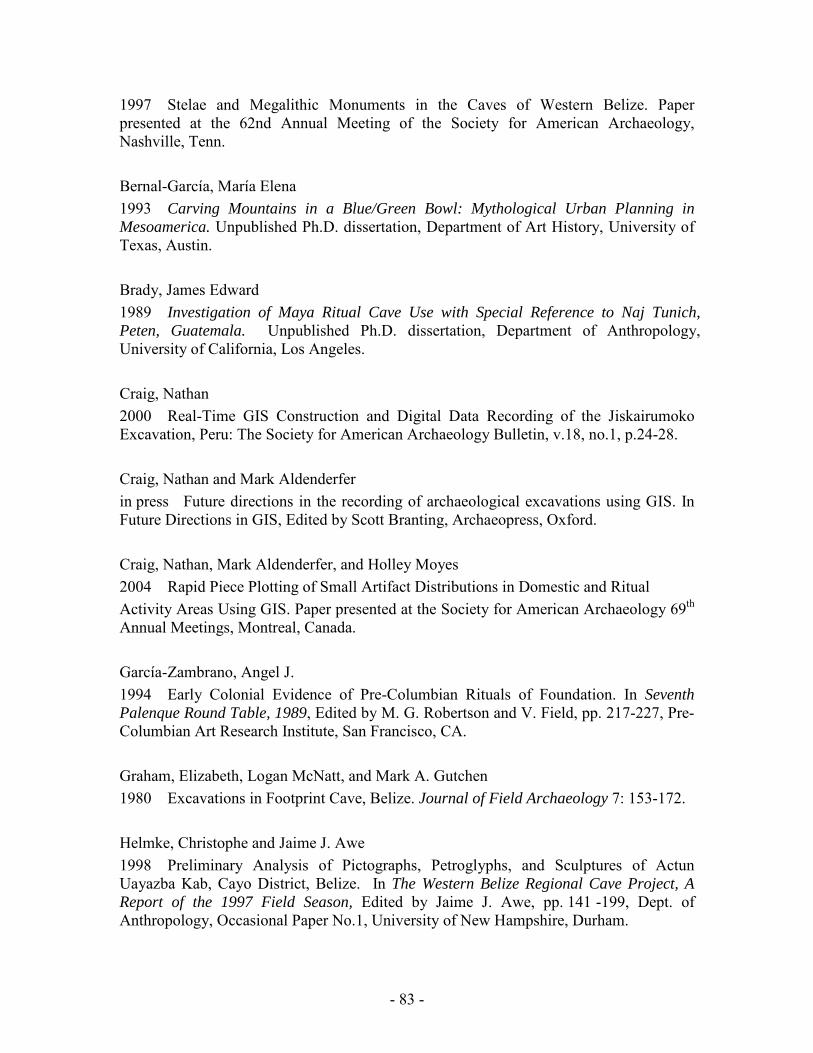
- 83 -
1997 Stelae and Megalithic Monuments in the Caves of Western Belize. Paper presented at the 62nd Annual Meeting of the Society for American Archaeology, Nashville, Tenn. Bernal-García, María Elena 1993 Carving Mountains in a Blue/Green Bowl: Mythological Urban Planning in Mesoamerica. Unpublished Ph.D. dissertation, Department of Art History, University of Texas, Austin. Brady, James Edward 1989 Investigation of Maya Ritual Cave Use with Special Reference to Naj Tunich, Peten, Guatemala. Unpublished Ph.D. dissertation, Department of Anthropology, University of California, Los Angeles. Craig, Nathan 2000 Real-Time GIS Construction and Digital Data Recording of the Jiskairumoko Excavation, Peru: The Society for American Archaeology Bulletin, v.18, no.1, p.24-28. Craig, Nathan and Mark Aldenderfer in press Future directions in the recording of archaeological excavations using GIS. In Future Directions in GIS, Edited by Scott Branting, Archaeopress, Oxford. Craig, Nathan, Mark Aldenderfer, and Holley Moyes 2004 Rapid Piece Plotting of Small Artifact Distributions in Domestic and Ritual Activity Areas Using GIS. Paper presented at the Society for American Archaeology 69th Annual Meetings, Montreal, Canada. García-Zambrano, Angel J. 1994 Early Colonial Evidence of Pre-Columbian Rituals of Foundation. In Seventh Palenque Round Table, 1989, Edited by M. G. Robertson and V. Field, pp. 217-227, Pre-Columbian Art Research Institute, San Francisco, CA. Graham, Elizabeth, Logan McNatt, and Mark A. Gutchen 1980 Excavations in Footprint Cave, Belize. Journal of Field Archaeology 7: 153-172. Helmke, Christophe and Jaime J. Awe 1998 Preliminary Analysis of Pictographs, Petroglyphs, and Sculptures of Actun Uayazba Kab, Cayo District, Belize. In The Western Belize Regional Cave Project, A Report of the 1997 Field Season, Edited by Jaime J. Awe, pp. 141 -199, Dept. of Anthropology, Occasional Paper No.1, University of New Hampshire, Durham.

- 84 -
1999 Exploration and Investigations of the Sinkhole Tunnels, Actun Tunichil Muknal, Belize. In The Western Belize Regional Cave Project: A Report of the 1998 Field Season, Edited by Jaime Awe, pp 146-165, Department of Anthropology Occasional Paper No. 2, Durham, University of New Hampshire. 2001 An Interpretation of the Pictographs and Petroglyphs of Actun Uayazba Kab: Implications for Ancient Maya Cave Rituals. Paper presented at the 66th Annual Meeting of the Society for American Archaeology, New Orleans. Iannone, Gyles 2001 Fall of the House of Minanhá: A Case of Late Classic Political Disruption in West Central Belize. In Archaeological Investigations in the North Vaca Plateau, Belize: Progress Report of the Third (2001) Field Season, Edited by Gyles Iannone, Ryan Primrose, Adam Menzies, and Lisa McParland, pp.127-133, Peterborough, Dept. of Anthropology, Trent University. Ishihara, Reiko 2000 An Investigation of the Ancient Maya Ritual Cave Activity at Actun Chechem Ha, Cayo District, Belize. Unpublished Honors Thesis, University of Tsukuba, Japan. Morehart, Christopher T. 2002a Ancient Maya Ritual Cave Utilization: A Paleoethnobotanical Perspective. Unpublished Master's Thesis, Department of Anthropology, Florida State University, Tallahassee. 2002b Plants of the Underworld: Ritual Plant Use in Ancient Maya Cave Ceremonies. Report submitted to the Foundation for the Advancement of Mesoamerican Studies, Inc. http://www.famsi.org/reports/morehart/morehart.htm Moyes, Holley 2001 The Cave as a Cosmogram: The Use of GIS in an Intrasite Spatial Analysis of The Main Chamber of Actun Tunichil Muknal, A Maya Ceremonial Cave in Western Belize. M.A. Thesis, Florida Atlantic University, Boca Raton, Florida. Pohl, Mary 1981 Ritual Continuity and Transformation in Mesoamerica: Reconstructing the Ancient Maya Cuch Ritual. American Antiquity 46:513-529. Pohl, Mary and John Pohl 1983 Ancient Maya Cave Ritual. Archaeology 36(3):28-51.
Reents-Budet, Doris Jane
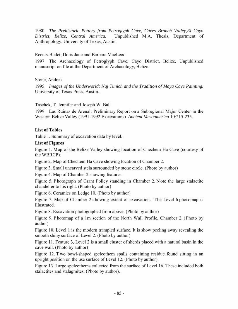
- 85 -
1980 The Prehistoric Pottery from Petroglyph Cave, Caves Branch Valley,El Cayo District, Belize, Central America. Unpublished M.A. Thesis, Department of Anthropology. University of Texas, Austin. Reents-Budet, Doris Jane and Barbara MacLeod 1997 The Archaeology of Petroglyph Cave, Cayo District, Belize. Unpublished manuscript on file at the Department of Archaeology, Belize. Stone, Andrea 1995 Images of the Underworld: Naj Tunich and the Tradition of Maya Cave Painting. University of Texas Press, Austin. Taschek, T. Jennifer and Joseph W. Ball 1999 Las Ruinas de Arenal: Preliminary Report on a Subregional Major Center in the Western Belize Valley (1991-1992 Excavations). Ancient Mesoamerica 10:215-235. List of Tables Table 1. Summary of excavation data by level. List of Figures Figure 1. Map of the Belize Valley showing location of Chechem Ha Cave (courtesy of the WBRCP). Figure 2. Map of Chechem Ha Cave showing location of Chamber 2. Figure 3. Small uncarved stela surrounded by stone circle. (Photo by author) Figure 4. Map of Chamber 2 showing features. Figure 5. P hotograph of Grant Polley standing in Chamber 2. N ote the large stalactite chandelier to his right. (Photo by author) Figure 6. Ceramics on Ledge 10. (Photo by author) Figure 7. Map of Chamber 2 showing extent of excavation. The Level 6 photomap is illustrated. Figure 8. Excavation photographed from above. (Photo by author) Figure 9. P hotomap of a 1m section of the North Wall Profile, Chamber 2. ( Photo by author) Figure 10. Level 1 is the modern trampled surface. It is show peeling away revealing the smooth shiny surface of Level 2. (Photo by author) Figure 11. Feature 3, Level 2 is a small cluster of sherds placed with a natural basin in the cave wall. (Photo by author) Figure 12. T wo bowl-shaped speleothem spalls containing residue found sitting in an upright position on the use surface of Level 12. (Photo by author) Figure 13. Large speleothems collected from the surface of Level 16. These included both stalactites and stalagmites. (Photo by author).

- 86 -
Figure 14. Density Difference map of Level 6. Areas of red and yellow are the highest unexpected densities and blue and green the lowest. Figure 15. Density Difference map of Level 7. Areas of red and yellow are the highest unexpected densities and blue and green the lowest. Figure 16. Graph of relative quantities of charcoal on surface and in between levels. Figure 17. G raph of calibrated radiocarbon AMS dates using Oxcal3 for excavated Layers 1-13 and the Stela Chamber.
Figure 1. Map of the Belize Valley showing location of Chechem Ha Cave (courtesy of the WBRCP).
- 87 -
Figure 2. Map of Chechem Ha Cave showing location of Chamber 2.
Figure 3. Small uncarved stela surrounded by stone circle. (Photo by author)

- 88 -
Figure 4. Map of Chamber 2 showing features.

- 89 -
Figure 5. P hotograph of Grant Polley standing in Chamber 2. N ote the large stalactite chandelier to his right. (Photo by author)
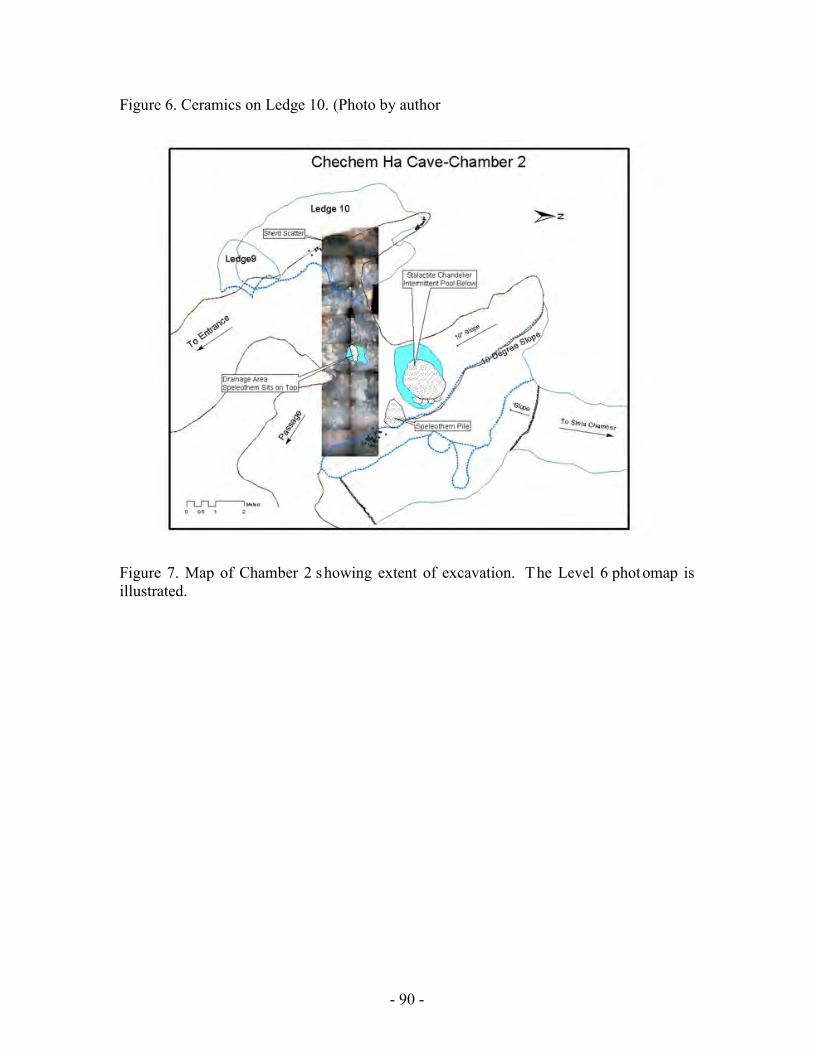
- 90 -
Figure 6. Ceramics on Ledge 10. (Photo by author
Figure 7. Map of Chamber 2 showing extent of excavation. The Level 6 photomap is illustrated.
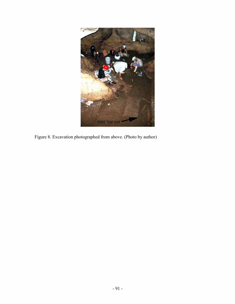
- 91 -
Figure 8. Excavation photographed from above. (Photo by author)

- 92 -
Figure 9. Photomap of a 1m section of Chamber 2 North Wall Profile. (Photo by author)

- 93 -
Figure 10. Level 1 is the modern trampled surface. It is show peeling away revealing the smooth shiny surface of Level 2. (Photo by author)

- 94 -
Figure 11. Feature 3, Level 2 is a small cluster of sherds placed with a natural basin in the cave wall. (Photo by author)
Figure 12. T wo bowl-shaped speleothem spalls containing residue found sitting in an upright position on the use surface of Level 12. (Photo by author)
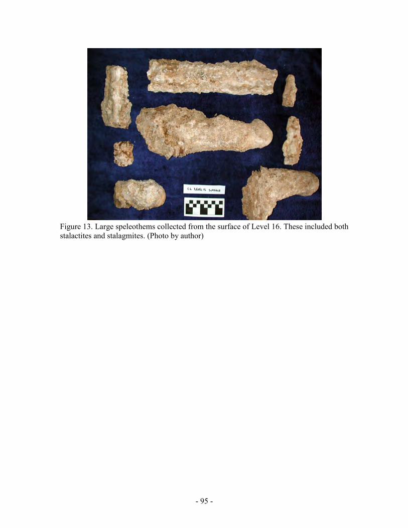
- 95 -
Figure 13. Large speleothems collected from the surface of Level 16. These included both stalactites and stalagmites. (Photo by author)

- 96 -

- 97 -
Figure 14. Density Difference map of Level 6. Areas of red and yellow are the highest unexpected densities and blue and green the lowest.
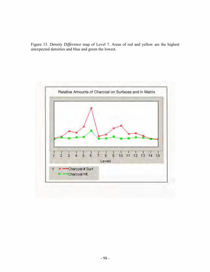
- 98 -
Figure 15. Density Difference map of Level 7. Areas of red and yellow are the highest unexpected densities and blue and green the lowest.

- 99 -

- 100 -
Figure 16. Graph of relative quantities of charcoal on surface and between levels.
Figure 17. G raph of calibrated radiocarbon AMS dates using Oxcal3 for excavated Layers 1-13 and the Stela Chamber. APPENDIX A Diagnostic Ceramics
Level 1 Level 2
Level 3 Level 4

- 101 -
Level 5 Level 6
Level 7 Level 8
Level 9 Level 10
Feature 1 Feature 3

- 102 -
Feature 5


